Extreme Lake Level Rise in the Zaysan Basin Driven by Intense Snowmelt Runoff
Highlights
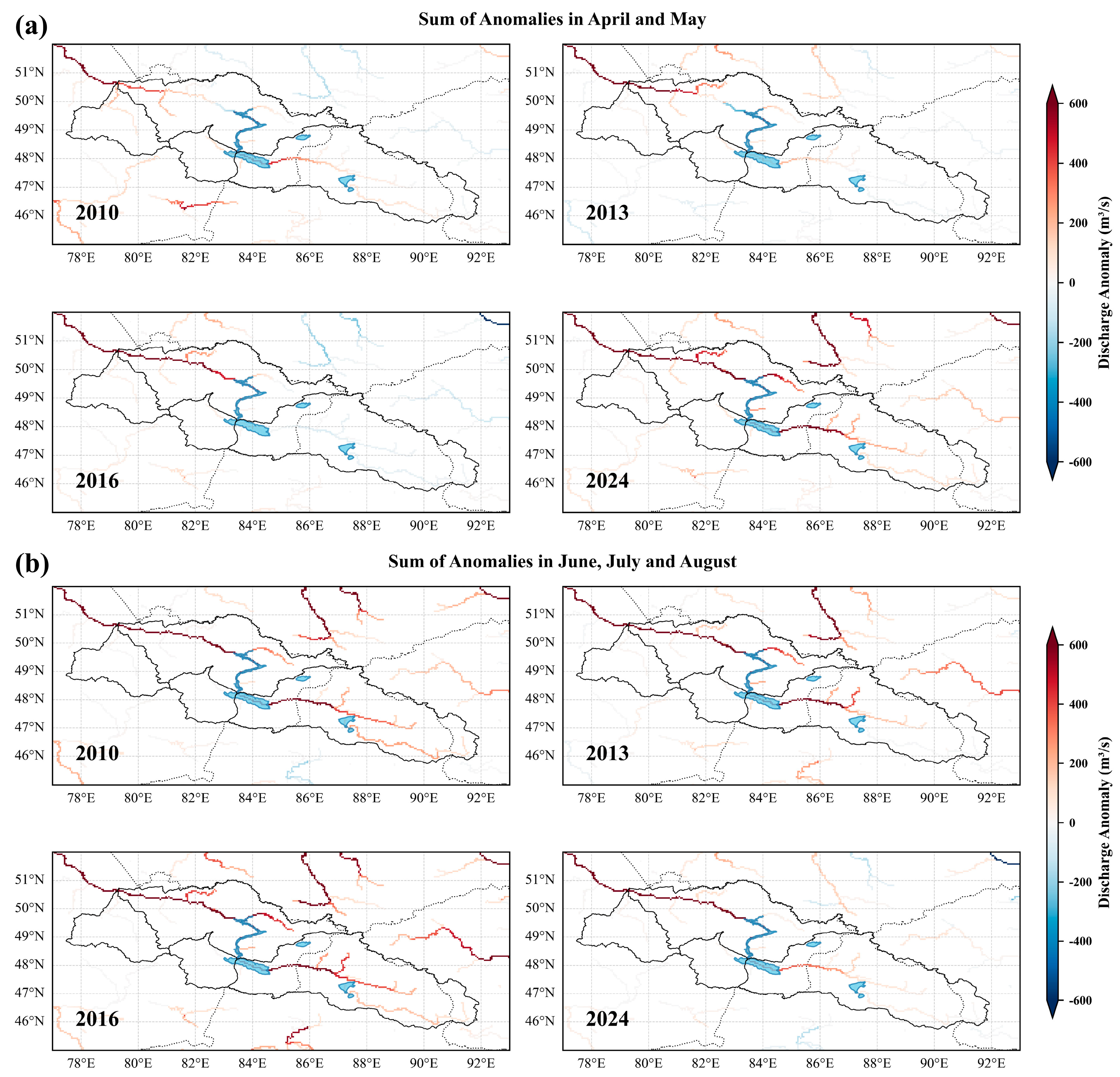
- Multi-mission satellite altimetry revealed extreme water level rises up to 5.12 m (21.47 Gt) in Lake Zaysan during 2010, 2013, and 2024.
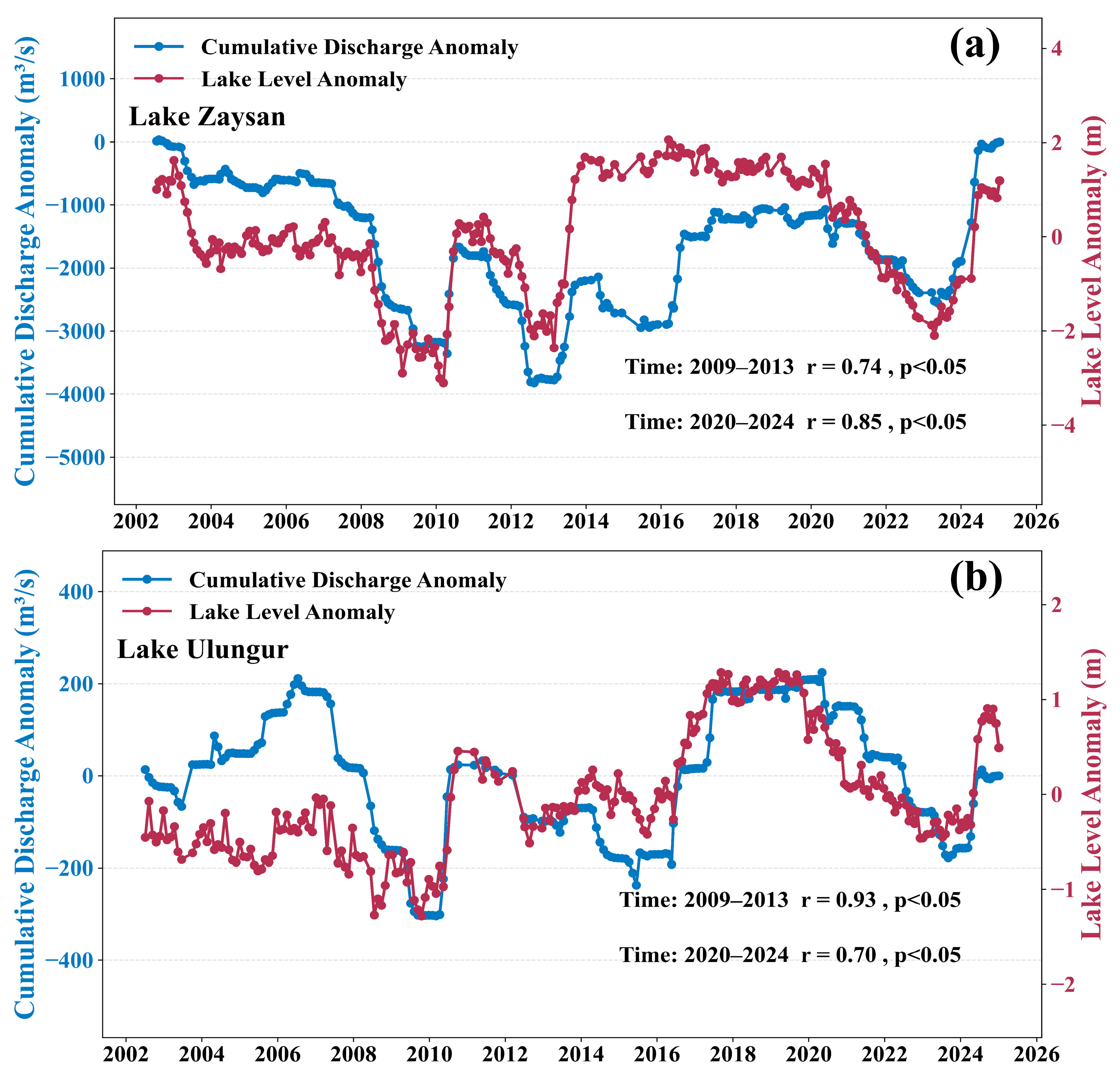
- Strong correlation (r = 0.95) between discharge anomalies and lake levels confirms intense snowmelt runoff as the primary driver of extreme events.
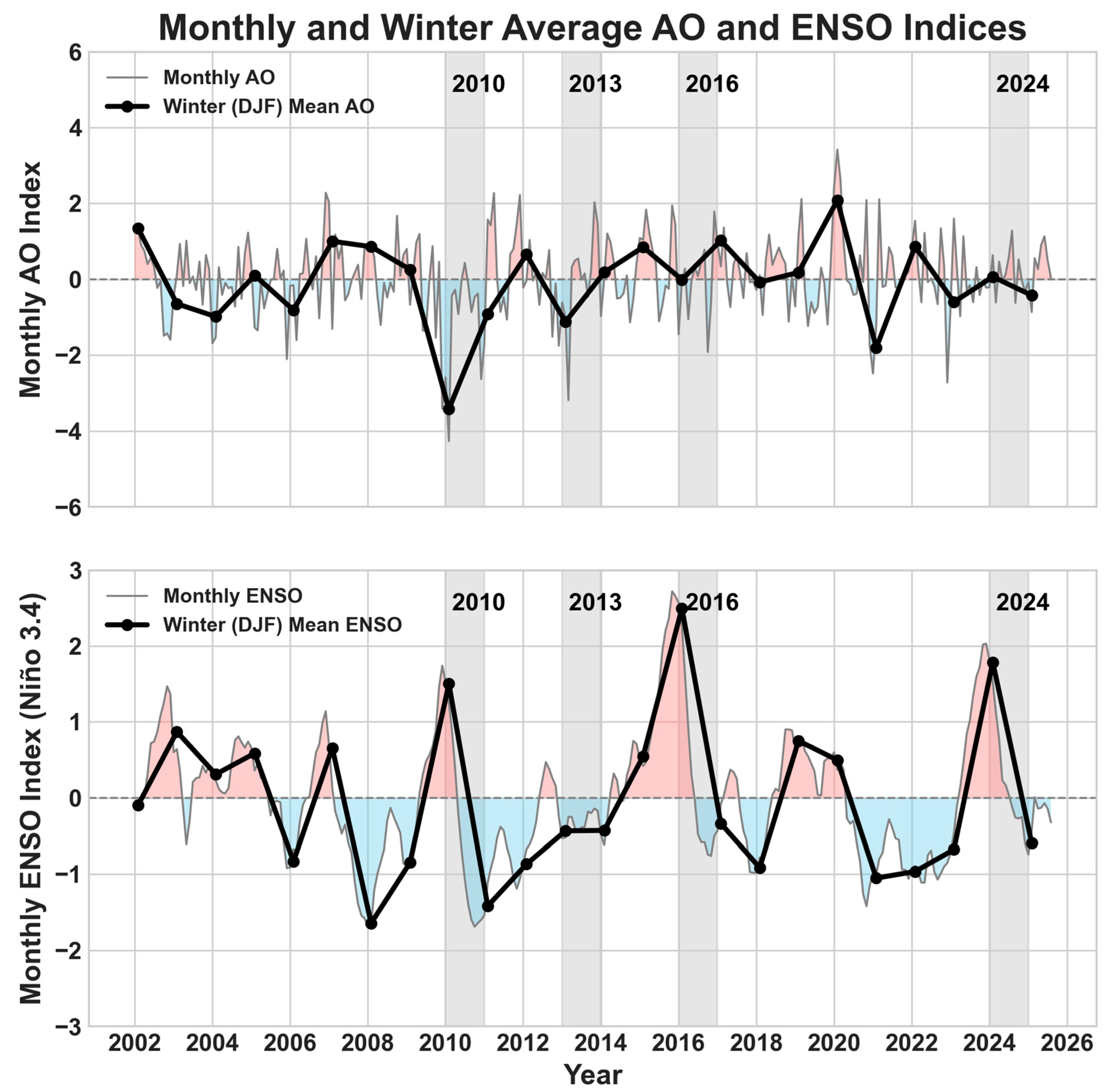
- Extreme events are driven by negative Arctic Oscillation phases (2010, 2013) and strong El Niño events (2016, 2024).
- The monitoring approach provides baseline data for transboundary water management in climate-sensitive Central Asian basins.
Abstract
1. Introduction
2. Data and Methods
2.1. Study Area
2.2. Altimetry Data
2.2.1. ICESat
2.2.2. ICESat-2
2.2.3. CryoSat-2
2.3. Climate Datasets
2.4. GloFAS
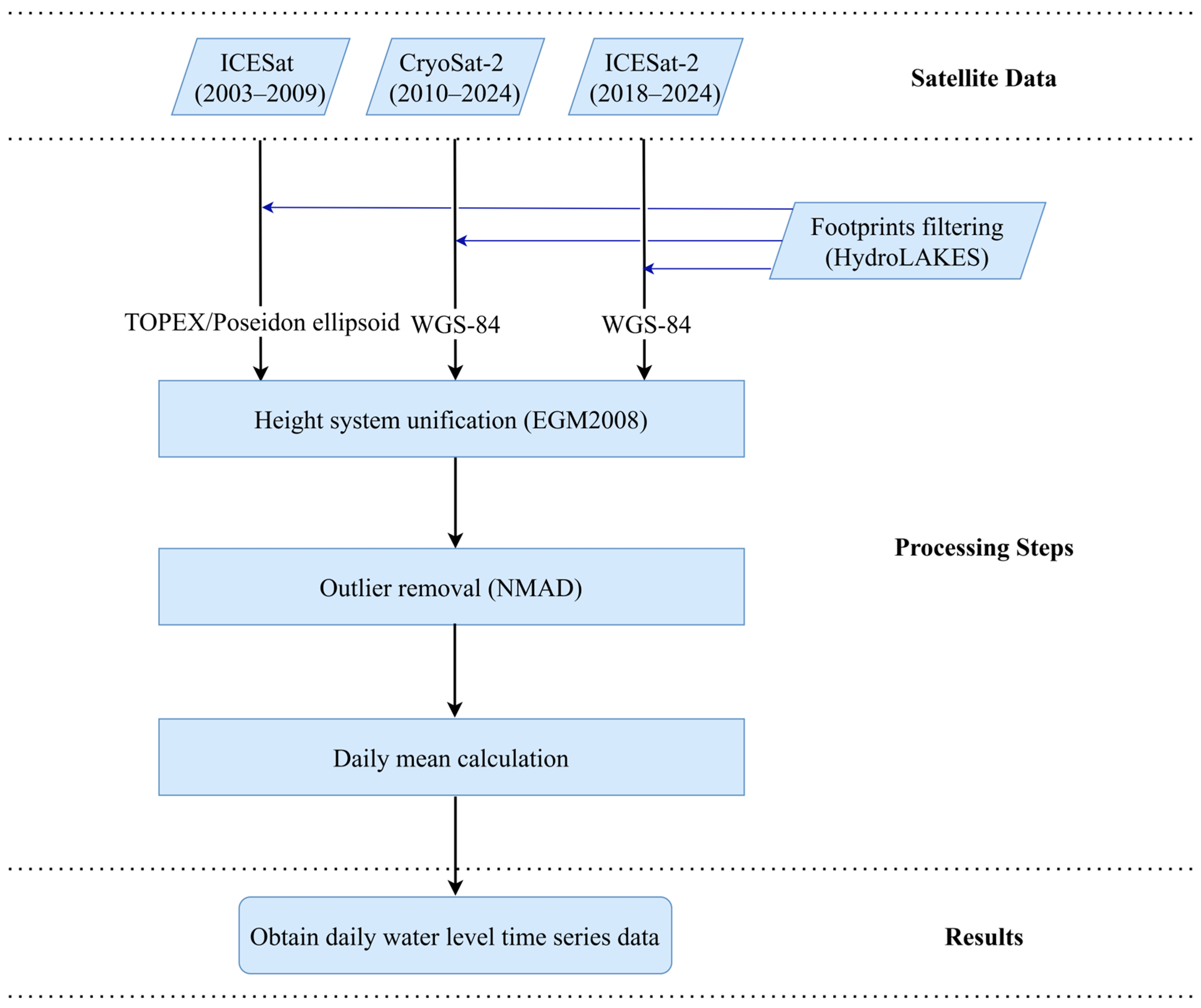
2.5. Multi-Source Satellite Altimetry Data Processing
3. Results
3.1. Reconstruction and Validation of Lake Water Levels Using Multi-Source Satellite Altimetry
3.2. Abrupt Lake-Level Changes
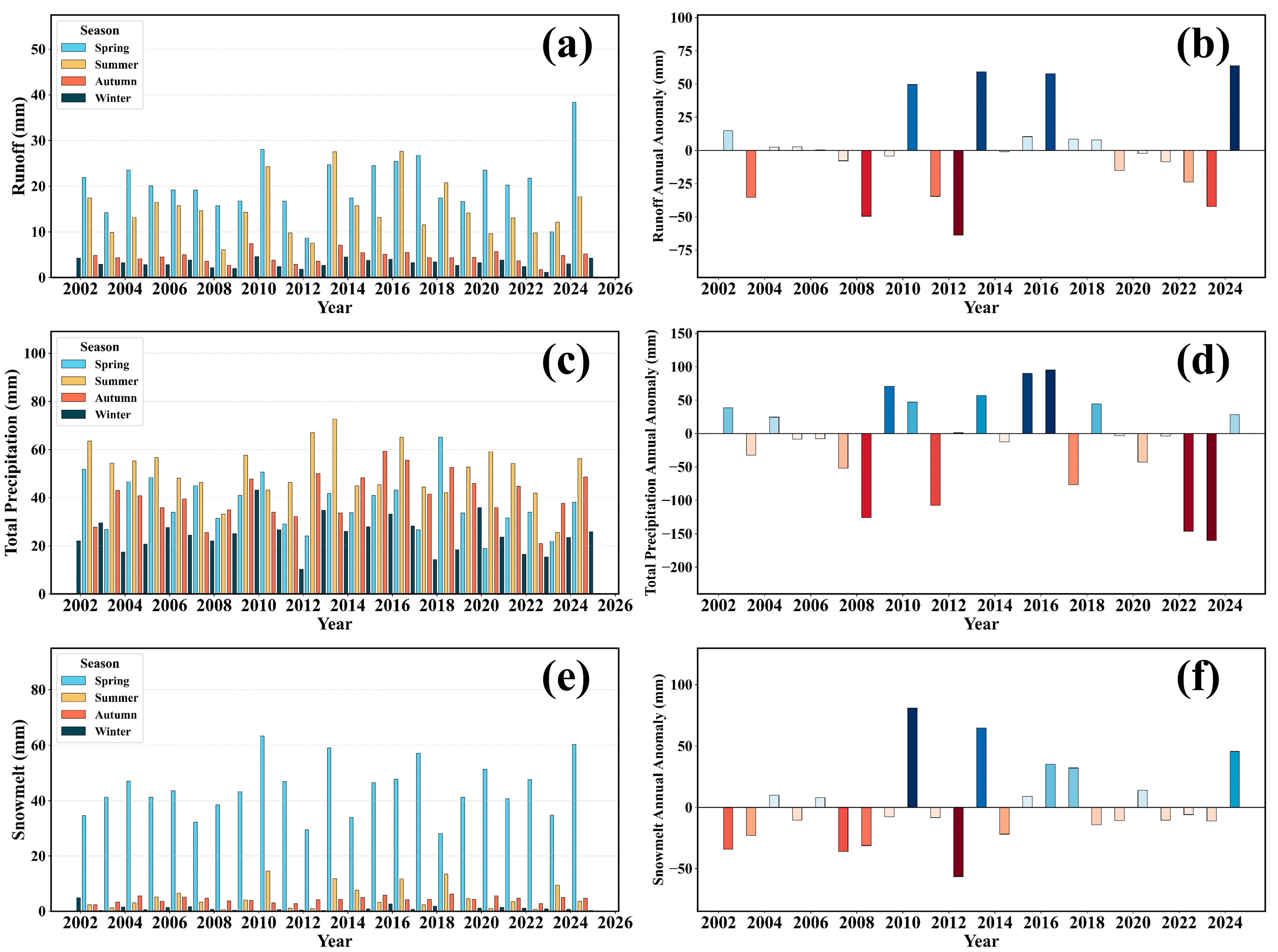
3.3. Hydro-Climatic Drivers of Abrupt Lake-Level Changes
3.4. River Discharge Dynamics and Spatial Patterns
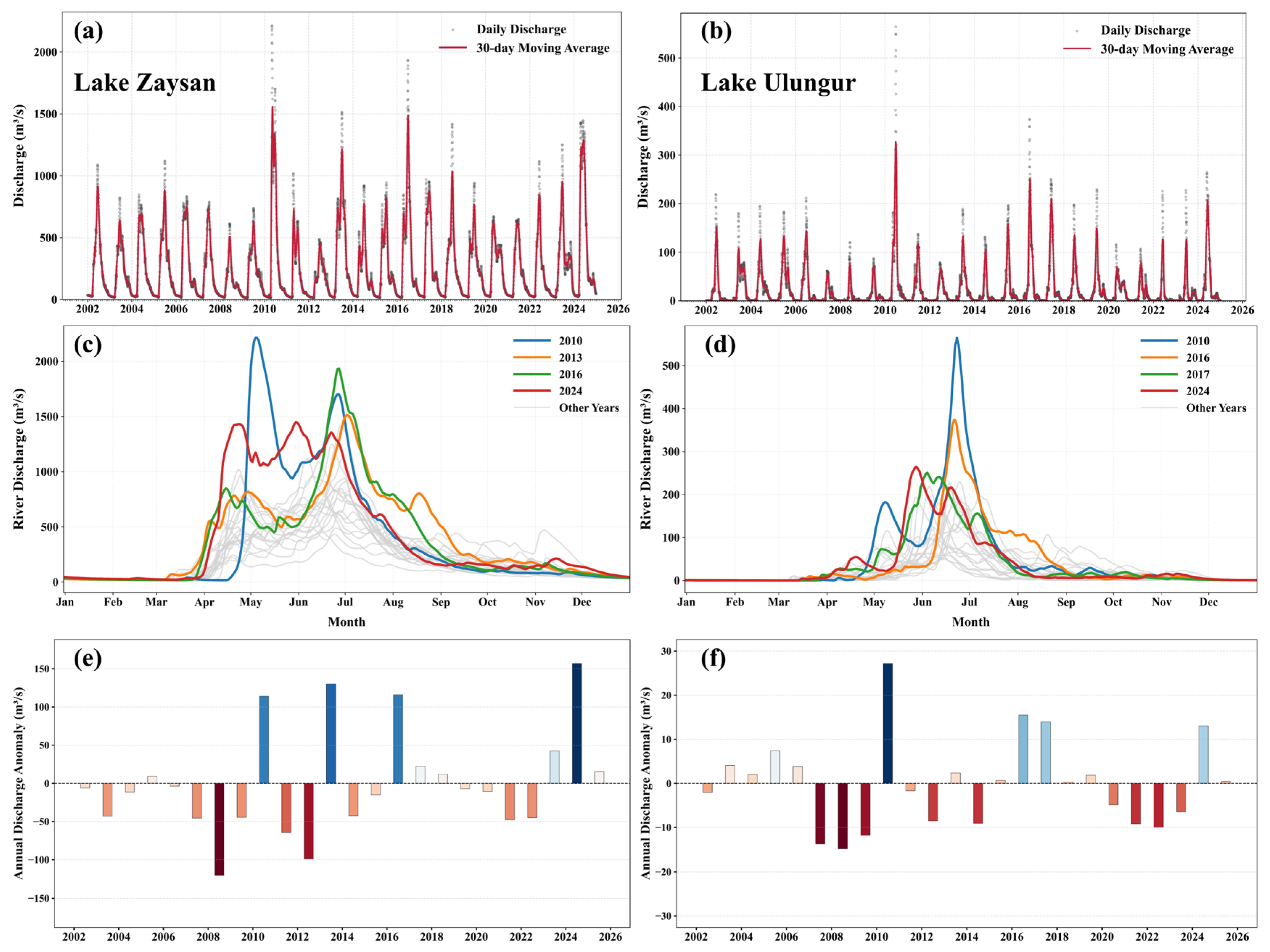
3.4.1. Seasonal Regimes and Annual Anomalies
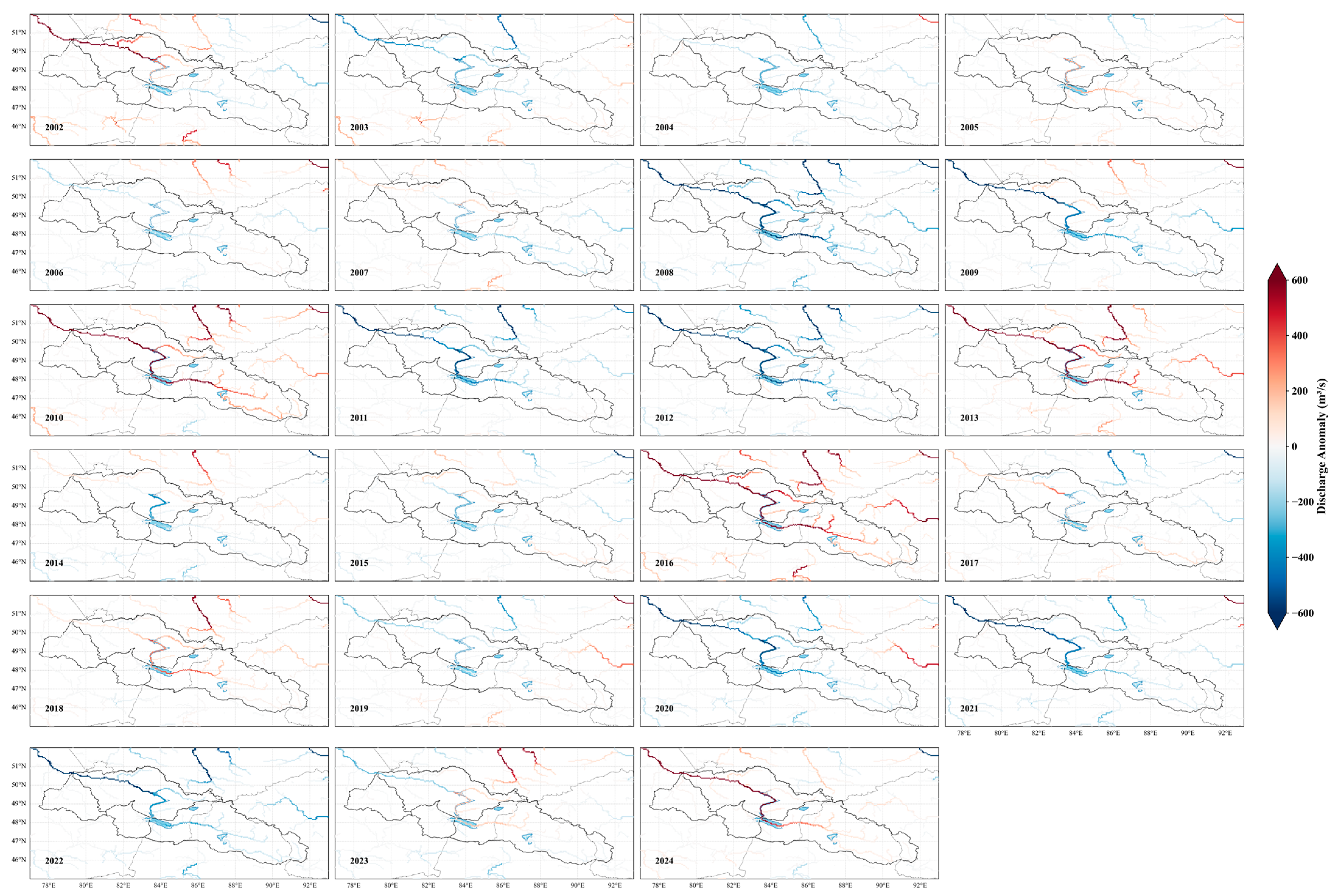
3.4.2. Spatial Distribution of Discharge Anomalies
4. Discussion
4.1. Hydrological Attribution and Climatic Teleconnections of Extreme Water Level Changes
4.2. Methodological Implications and Limitations of Multi-Source Data Fusion
4.3. Implications for Adaptive Management in a Transboundary Basin
5. Conclusions
Author Contributions
Funding
Data Availability Statement
Acknowledgments
Conflicts of Interest
Appendix A

References
- Williamson, C.E.; Saros, J.E.; Vincent, W.F.; Smol, J.P. Lakes and Reservoirs as Sentinels, Integrators, and Regulators of Climate Change. Limnol. Oceanogr. 2009, 54, 2273–2282. [Google Scholar] [CrossRef]
- Woolway, R.I.; Kraemer, B.M.; Lenters, J.D.; Merchant, C.J.; O’Reilly, C.M.; Sharma, S. Global Lake Responses to Climate Change. Nat. Rev. Earth Env. 2020, 1, 388–403. [Google Scholar] [CrossRef]
- Cooley, S.W.; Ryan, J.C.; Smith, L.C. Human Alteration of Global Surface Water Storage Variability. Nature 2021, 591, 78–81. [Google Scholar] [CrossRef]
- Bai, J.; Chen, X.; Li, J.; Yang, L.; Fang, H. Changes in the Area of Inland Lakes in Arid Regions of Central Asia during the Past 30 Years. Env. Monit. Assess. 2011, 178, 247–256. [Google Scholar] [CrossRef]
- Yao, F.; Livneh, B.; Rajagopalan, B.; Wang, J.; Crétaux, J.-F.; Wada, Y.; Berge-Nguyen, M. Satellites Reveal Widespread Decline in Global Lake Water Storage. Science 2023, 380, 743–749. [Google Scholar] [CrossRef]
- Xu, F.; Zhang, G.; Yi, S.; Chen, W. Seasonal Trends and Cycles of Lake-Level Variations over the Tibetan Plateau Using Multi-Sensor Altimetry Data. J. Hydrol. 2022, 604, 127251. [Google Scholar] [CrossRef]
- Song, L.; Song, C.; Luo, S.; Chen, T.; Liu, K.; Zhang, Y.; Ke, L. Integrating ICESat-2 Altimetry and Machine Learning to Estimate the Seasonal Water Level and Storage Variations of National-Scale Lakes in China. Remote Sens. Environ. 2023, 294, 113657. [Google Scholar] [CrossRef]
- Wang, Q.; Yi, S.; Sun, W. The Changing Pattern of Lake and Its Contribution to Increased Mass in the Tibetan Plateau Derived from GRACE and ICESat Data. Geophys. J. Int. 2016, 207, 528–541. [Google Scholar] [CrossRef]
- Karatayev, M.; Rivotti, P.; Sobral Mourão, Z.; Konadu, D.D.; Shah, N.; Clarke, M. The Water-Energy-Food Nexus in Kazakhstan: Challenges and Opportunities. Energy Procedia 2017, 125, 63–70. [Google Scholar] [CrossRef]
- Wen, Z.; Yi, S.; Sun, W. Significant Contribution of the Tianshan Lakes to Their Water Storage and Water Resources. J. Hydrol. Reg. Stud. 2024, 53, 101813. [Google Scholar] [CrossRef]
- Zhu, E.; Samat, A.; Li, W.; Xu, R.; Xia, J.; Qiu, Y.; Abuduwaili, J. Intra- and Inter-Annual Spatiotemporal Variations and Climatic Driving Factors of Surface Water Area in the Irtysh River Basin during 1985–2022. Remote Sens. Appl. Soc. Environ. 2025, 37, 101455. [Google Scholar] [CrossRef]
- Li, J.; Xia, Z.; Yin, W.; Jia, H. Instream Ecological Flow and Reservoir Ecological Operation in the Upper Reaches of Irtysh River. MATEC Web Conf. 2018, 246, 01103. [Google Scholar] [CrossRef]
- Wu, X.; Zhang, W.; Li, H.; Long, Y.; Pan, X.; Shen, Y. Analysis of Seasonal Snowmelt Contribution Using a Distributed Energy Balance Model for a River Basin in the Altai Mountains of Northwestern China. Hydrol. Process. 2021, 35, e14046. [Google Scholar] [CrossRef]
- Huang, W.; Duan, W.; Nover, D.; Sahu, N.; Chen, Y. An Integrated Assessment of Surface Water Dynamics in the Irtysh River Basin during 1990–2019 and Exploratory Factor Analyses. J. Hydrol. 2021, 593, 125905. [Google Scholar] [CrossRef]
- Radelyuk, I.; Zhang, L.; Assanov, D.; Maratova, G.; Tussupova, K. A State-of-the-Art and Future Perspectives of Transboundary Rivers in the Cold Climate—A Systematic Review of Irtysh River. J. Hydrol. Reg. Stud. 2022, 42, 101173. [Google Scholar] [CrossRef]
- Zhang, W.; Kang, S.; Shen, Y.; He, J.; Chen, A. Response of Snow Hydrological Processes to a Changing Climate during 1961 to 2016 in the Headwater of Irtysh River Basin, Chinese Altai Mountains. J. Mt. Sci. 2017, 14, 2295–2310. [Google Scholar] [CrossRef]
- Yang, Y.; Wu, X.-J.; Liu, S.-W.; Xiao, C.-D.; Wang, X. Valuating Service Loss of Snow Cover in Irtysh River Basin. Adv. Clim. Change Res. 2019, 10, 109–114. [Google Scholar] [CrossRef]
- Fugazza, D.; Shaw, T.E.; Mashtayeva, S.; Brock, B. Inter-annual Variability in Snow Cover Depletion Patterns and Atmospheric Circulation Indices in the Upper Irtysh Basin, Central Asia. Hydrol. Process. 2020, 34, 3738–3757. [Google Scholar] [CrossRef]
- Messager, M.L.; Lehner, B.; Grill, G.; Nedeva, I.; Schmitt, O. Estimating the Volume and Age of Water Stored in Global Lakes Using a Geo-Statistical Approach. Nat. Commun. 2016, 7, 13603. [Google Scholar] [CrossRef]
- Wang, Q.; Yi, S.; Sun, W. Continuous Estimates of Glacier Mass Balance in High Mountain Asia Based on ICESat-1,2 and GRACE/GRACE Follow-On Data. Geophys. Res. Lett. 2021, 48, e2020GL090954. [Google Scholar] [CrossRef]
- Wang, Q.; Sun, W. Seasonal Cycles of High Mountain Asia Glacier Surface Elevation Detected by ICESat-2. JGR Atmospheres 2022, 127, e2022JD037501. [Google Scholar] [CrossRef]
- Markus, T.; Neumann, T.; Martino, A.; Abdalati, W.; Brunt, K.; Csatho, B.; Farrell, S.; Fricker, H.; Gardner, A.; Harding, D.; et al. The Ice, Cloud, and Land Elevation Satellite-2 (ICESat-2): Science Requirements, Concept, and Implementation. Remote Sens. Environ. 2017, 190, 260–273. [Google Scholar] [CrossRef]
- Lehner, B.; Grill, G. Global River Hydrography and Network Routing: Baseline Data and New Approaches to Study the World’s Large River Systems. Hydrol. Process. 2013, 27, 2171–2186. [Google Scholar] [CrossRef]
- Zwally, H.J.; Schutz, B.; Abdalati, W.; Abshire, J.; Bentley, C.; Brenner, A.; Bufton, J.; Dezio, J.; Hancock, D.; Harding, D.; et al. ICESat’s Laser Measurements of Polar Ice, Atmosphere, Ocean, and Land. J. Geodyn. 2002, 34, 405–445. [Google Scholar] [CrossRef]
- Schutz, B.E.; Zwally, H.J.; Shuman, C.A.; Hancock, D.; DiMarzio, J.P. Overview of the ICESat Mission. Geophys. Res. Lett. 2005, 32, 2005GL024009. [Google Scholar] [CrossRef]
- Zhang, G.; Chen, W.; Xie, H. Tibetan Plateau’s Lake Level and Volume Changes from NASA’s ICESat/ICESat-2 and Landsat Missions. Geophys. Res. Lett. 2019, 46, 13107–13118. [Google Scholar] [CrossRef]
- Bhang, K.J.; Schwartz, F.W.; Braun, A. Verification of the Vertical Error in C-Band SRTM DEM Using ICESat and Landsat-7, Otter Tail County, MN. IEEE Trans. Geosci. Remote Sens. 2007, 45, 36–44. [Google Scholar] [CrossRef]
- Song, C.; Ye, Q.; Sheng, Y.; Gong, T. Combined ICESat and CryoSat-2 Altimetry for Accessing Water Level Dynamics of Tibetan Lakes over 2003–2014. Water 2015, 7, 4685–4700. [Google Scholar] [CrossRef]
- Zwally, H.J.; Schutz, R.; Hancock, D.; DiMarzio, J. GLAS/ICESat L2 Global Land Surface Altimetry Data (HDF5); Version 34; NASA National Snow and Ice Data Center Distributed Active Archive Center: Boulder, CO, USA, 2014; Available online: https://doi.org/10.5067/ICESAT/GLAS/DATA211 (accessed on 15 April 2025).
- Neumann, T.A.; Martino, A.J.; Markus, T.; Bae, S.; Bock, M.R.; Brenner, A.C.; Brunt, K.M.; Cavanaugh, J.; Fernandes, S.T.; Hancock, D.W.; et al. The Ice, Cloud, and Land Elevation Satellite—2 Mission: A Global Geolocated Photon Product Derived from the Advanced Topographic Laser Altimeter System. Remote Sens. Environ. 2019, 233, 111325. [Google Scholar] [CrossRef]
- Jasinski, M.; Stoll, J.; Hancock, D.; Robbins, J.; Nattala, J.; Pavelsky, T.; Morrison, J.; Jones, B.; Ondrusek, M.; Parrish, C.; et al. ICESat-2 Science Team. ATLAS/ICESat-2 L3A ICESat-2 Along Track Inland Surface Water Data, Release 6; NASA National Snow and Ice Data Center Distributed Active Archive Center: Boulder, CO, USA, 2023; Available online: https://nsidc.org/data/atl13/versions/6 (accessed on 15 April 2025).
- Wingham, D.J.; Francis, C.R.; Baker, S.; Bouzinac, C.; Brockley, D.; Cullen, R.; De Chateau-Thierry, P.; Laxon, S.W.; Mallow, U.; Mavrocordatos, C.; et al. CryoSat: A Mission to Determine the Fluctuations in Earth’s Land and Marine Ice Fields. Adv. Space Res. 2006, 37, 841–871. [Google Scholar] [CrossRef]
- Labroue, S.; Boy, F.; Picot, N.; Urvoy, M.; Ablain, M. First Quality Assessment of the Cryosat-2 Altimetric System over Ocean. Adv. Space Res. 2012, 50, 1030–1045. [Google Scholar] [CrossRef]
- Jiang, L.; Nielsen, K.; Andersen, O.B.; Bauer-Gottwein, P. Monitoring Recent Lake Level Variations on the Tibetan Plateau Using CryoSat-2 SARIn Mode Data. J. Hydrol. 2017, 544, 109–124. [Google Scholar] [CrossRef]
- Zhang, H.; Kou, X.; Xu, H.; Yi, S.; Sun, W.; Wang, Q. Assessing CryoSat-2 Satellite’s Seasonal Accuracy in Lake Water Level Monitoring. Geod. Geodyn. 2025, 16, 172–182. [Google Scholar] [CrossRef]
- Baba, M.W.; Boudhar, A.; Gascoin, S.; Hanich, L.; Marchane, A.; Chehbouni, A. Assessment of MERRA-2 and ERA5 to Model the Snow Water Equivalent in the High Atlas (1981–2019). Water 2021, 13, 890. [Google Scholar] [CrossRef]
- Hersbach, H.; Bell, B.; Berrisford, P.; Hirahara, S.; Horányi, A.; Muñoz-Sabater, J.; Nicolas, J.; Peubey, C.; Radu, R.; Schepers, D.; et al. The ERA5 Global Reanalysis. Quart. J. R. Meteoro. Soc. 2020, 146, 1999–2049. [Google Scholar] [CrossRef]
- Harrigan, S.; Zsoter, E.; Alfieri, L.; Prudhomme, C.; Salamon, P.; Wetterhall, F.; Barnard, C.; Cloke, H.; Pappenberger, F. GloFAS-ERA5 Operational Global River Discharge Reanalysis 1979–Present. Earth Syst. Sci. Data 2020, 12, 2043–2060. [Google Scholar] [CrossRef]
- Prudhomme, C.; Zsótér, E.; Matthews, G.; Melet, A.; Grimaldi, S.; Zuo, H.; Hansford, E.; Harrigan, S.; Mazzetti, C.; De Boisseson, E.; et al. Global Hydrological Reanalyses: The Value of River Discharge Information for World-wide Downstream Applications—The Example of the Global Flood Awareness System GloFAS. Meteorol. Appl. 2024, 31, e2192. [Google Scholar] [CrossRef]
- Alfieri, L.; Lorini, V.; Hirpa, F.A.; Harrigan, S.; Zsoter, E.; Prudhomme, C.; Salamon, P. A Global Streamflow Reanalysis for 1980–2018. J. Hydrol. X 2020, 6, 100049. [Google Scholar] [CrossRef]
- Luo, S.; Song, C.; Ke, L.; Zhan, P.; Fan, C.; Liu, K.; Chen, T.; Wang, J.; Zhu, J. Satellite Laser Altimetry Reveals a Net Water Mass Gain in Global Lakes with Spatial Heterogeneity in the Early 21st Century. Geophys. Res. Lett. 2022, 49, e2021GL096676. [Google Scholar] [CrossRef]
- Höhle, J.; Höhle, M. Accuracy Assessment of Digital Elevation Models by Means of Robust Statistical Methods. ISPRS J. Photogramm. Remote Sens. 2009, 64, 398–406. [Google Scholar] [CrossRef]
- Graham, R.M.; Hudson, S.R.; Maturilli, M. Improved Performance of ERA5 in Arctic Gateway Relative to Four Global Atmospheric Reanalyses. Geophys. Res. Lett. 2019, 46, 6138–6147. [Google Scholar] [CrossRef]
- Chen, S.; Yang, H.; Zheng, H. Intercomparison of Runoff and River Discharge Reanalysis Datasets at the Upper Jinsha River, an Alpine River on the Eastern Edge of the Tibetan Plateau. Water 2025, 17, 871. [Google Scholar] [CrossRef]



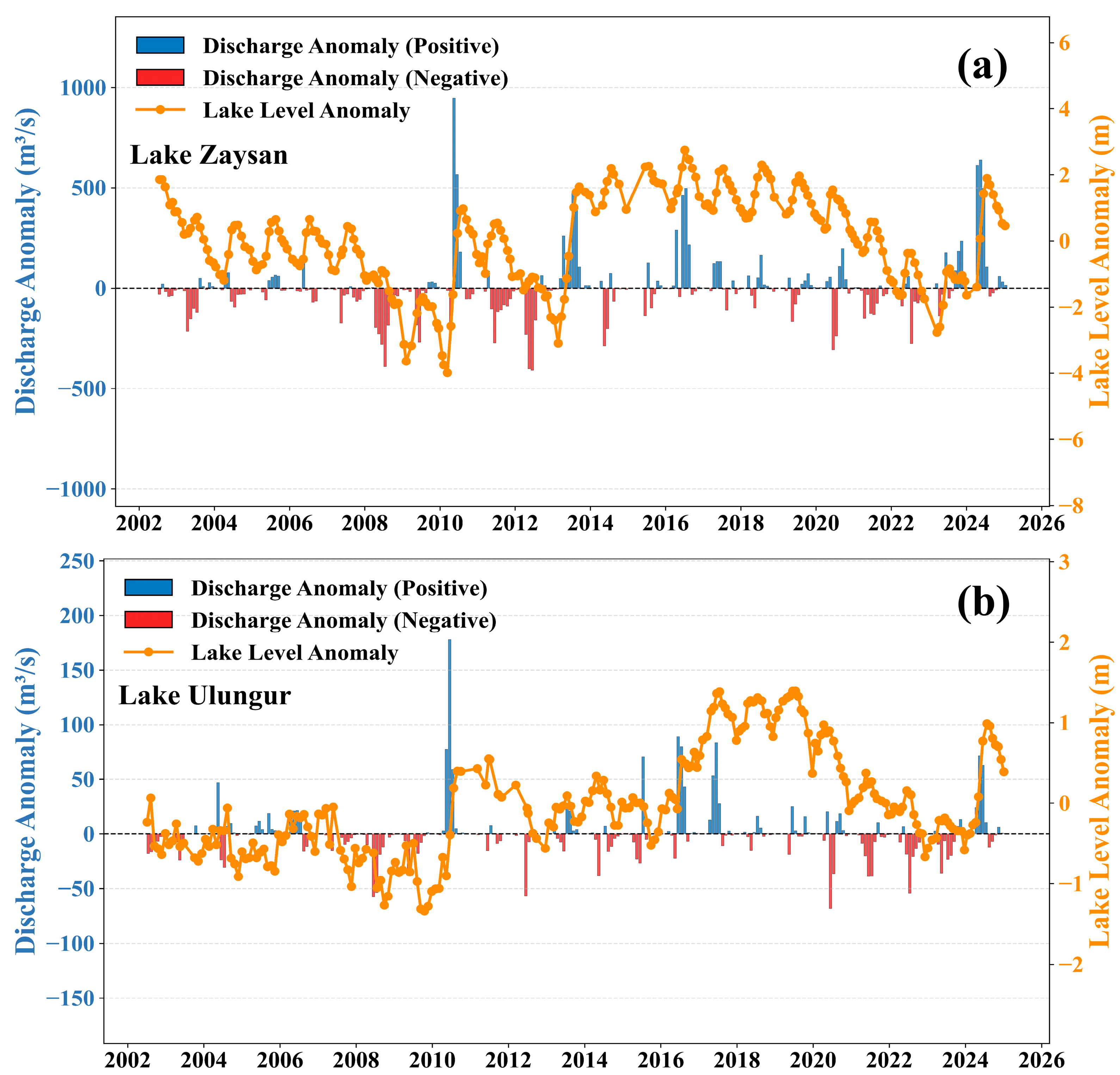
| Lake Name | Year | Min Level (m) | Min Level Date | Max Level (m) | Max Level Date | Level Change (m) | Mass Change (Gt) |
|---|---|---|---|---|---|---|---|
| Zaysan | 2010 | 388.62 | 2010-03-12 | 393.63 | 2010-08-08 | 5.01 | 21.01 |
| 2013 | 390.35 | 2013-02-26 | 394.29 | 2013-09-14 | 5.12 | 21.47 | |
| 2024 | 391.02 | 2024-01-02 | 394.55 | 2024-07-09 | 3.53 | 14.80 | |
| Ulungur | 2010 | 482.52 | 2010-01-30 | 483.99 | 2010-08-28 | 1.46 | 1.46 |
| 2016 | 483.37 | 2016-04-15 | 484.98 | 2017-09-06 | 1.61 | 1.64 | |
| 2024 | 483.19 | 2024-01-18 | 484.69 | 2024-07-28 | 1.50 | 1.53 |
Disclaimer/Publisher’s Note: The statements, opinions and data contained in all publications are solely those of the individual author(s) and contributor(s) and not of MDPI and/or the editor(s). MDPI and/or the editor(s) disclaim responsibility for any injury to people or property resulting from any ideas, methods, instructions or products referred to in the content. |
© 2025 by the authors. Licensee MDPI, Basel, Switzerland. This article is an open access article distributed under the terms and conditions of the Creative Commons Attribution (CC BY) license (https://creativecommons.org/licenses/by/4.0/).
Share and Cite
Xue, Y.; Wang, Q.; Zhang, H.; Xu, H.; Sun, W. Extreme Lake Level Rise in the Zaysan Basin Driven by Intense Snowmelt Runoff. Remote Sens. 2025, 17, 3755. https://doi.org/10.3390/rs17223755
Xue Y, Wang Q, Zhang H, Xu H, Sun W. Extreme Lake Level Rise in the Zaysan Basin Driven by Intense Snowmelt Runoff. Remote Sensing. 2025; 17(22):3755. https://doi.org/10.3390/rs17223755
Chicago/Turabian StyleXue, Yu, Qiuyu Wang, Huake Zhang, Huan Xu, and Wenke Sun. 2025. "Extreme Lake Level Rise in the Zaysan Basin Driven by Intense Snowmelt Runoff" Remote Sensing 17, no. 22: 3755. https://doi.org/10.3390/rs17223755
APA StyleXue, Y., Wang, Q., Zhang, H., Xu, H., & Sun, W. (2025). Extreme Lake Level Rise in the Zaysan Basin Driven by Intense Snowmelt Runoff. Remote Sensing, 17(22), 3755. https://doi.org/10.3390/rs17223755


