1. Introduction
Farmland, its soil, and people’s livelihoods have been directly associated since the beginning of human civilization [
1,
2]. Increasing global population and higher food demand resulted in the continuous expansion of farmland from the 17th to the 20th centuries [
3]. The global population and food demand are still growing today [
4,
5]; however, farmland abandonment has been commonly observed in recent decades [
6], leading to many socioecological impacts. The effects of farmland abandonment are particularly evident on food security, threatening people’s livelihoods [
7,
8]. From an environmental conservation perspective, the abandonment of farmland creates opportunities for vegetation succession, ecological restoration, and carbon sequestration [
9]. The effects of farmland abandonment vary based on the socioecological status of different ecological regions [
10].
In recent years, monitoring farmland abandonment has been a prioritized research issue; however, consistent information and abandoned farmland maps, as well as reliable methods for generating such information are lacking. Two methods—either farmland abandonment mapping based on satellite imagery or field surveys including household data—are used for generating the data on farmland abandonment.
The field survey including household interviews approach allows researchers to quickly and accurately understand the mechanisms of farmland abandonment. It requires a large sample size, and the results are influenced by the number of surveyed households, spatial sampling methods, and survey techniques [
11]. The United Nations Food and Agriculture Organization (FAO) defines farmland abandonment as the cessation of agricultural activities on land for a period of five consecutive years or more, during which the land is not managed for agricultural purposes and shows no significant signs of human intervention for farming activities [
12]. It is crucial to recognize farmland abandoned for over five years to map its actual status and situations accurately. In some cases, farmers may temporarily recultivate abandoned farmland due to changes in country policies and economic conditions [
13,
14]. Such factors pose challenges in accurately monitoring and mapping farmland abandonment using satellite remote-sensing data without ground truthing. In recent years, remote-sensing data and approaches have played a key role in measuring the spatial extent of farmland abandonment. Studies on farmland abandonment have been conducted at global [
6], regional [
15], and local scales [
10] using various remote-sensing products and artificial intelligence (AI) approaches [
16,
17,
18,
19]. Many previous studies covered larger areas with coarse-resolution remote-sensing data, such as 250 m Moderate Resolution Imaging Spectroradiometer (MODIS) data [
20] and 30 m Landsat images [
21]. Measuring the precise status of abandoned farmland at local scales using coarse-resolution remote-sensing products is always challenging. The gradual, complex, and unstable nature of farmland abandonment and its scattered spatial distribution always added challenges to monitoring the precise status of abandoned farmland [
22]. This difficulty is particularly pronounced due to the presence of mixed pixels [
23]. High-resolution satellite imagery, such as Ikonos, DigitalGlobe, Quickbird, and GaoFen, which provide 2 m or higher resolution imagery, can help overcome these challenges and precisely measure abandoned farmland at local scales.
High-resolution satellite imagery alone may not be sufficient to measure abandoned farmland accurately, especially in mountainous topographies. Therefore, the people-to-pixel approach can be particularly effective. This approach is used for small-scale land-use and land-cover (LULC) monitoring [
24]. This approach integrates local knowledge and information from the field with high-resolution remote-sensing products, enhancing the accuracy of mapping efforts.
A previous study reported that the area of abandoned farmland in the Nepal Himalaya has been expanding in recent years [
25]. This issue is a concern for central, provincial, and local governments as well as communities and farmers. Some studies on farmland abandonment have been conducted in various parts of the Nepal Himalaya [
26,
27,
28], with the majority adopting perception-based approaches to evaluate the status of farmland abandonment. Only a few studies have used high-resolution data in specific areas and basins [
10]. This indicates a lack of precise measurement and mapping of abandoned farmland that represents villages in different ecological regions, including the Mountain, Hill, and Tarai regions, providing a broad scenario of farmland abandonment in the Nepal Himalaya. To fill this research gap, the main goal of the work is to conduct high-resolution remote-sensing-based mapping of farmland abandonment and the status of this land in different ecological villages of the Nepal Himalaya using the people-to-pixel approach to accurately map abandoned farmland. It is hoped that the evaluated data would help to formulate and implement policies, action plans, and strategies for the central, provincial, and local governments of Nepal and for similar topographies around the globe. Additionally, the data will be useful for other studies associated with farmland abandonment, food security, vegetation succession, carbon sequestration, and ecological restoration.
This work specifically addresses and answers two questions: (1) What is the status (proportion) of farmland abandonment in different ecological villages? and (2) What is the current condition of abandoned farmland in different ecological villages? Aligned with the United Nations Sustainable Development Goals (SDG), specifically SDG 15: Life on Land, the insights from these questions can help policymakers develop and refine strategies for sustainable farmland management, thereby ensuring food security, rural revitalization, and enhancing people’s livelihoods.
2. Materials and Methods
2.1. Study Area
This work focuses on different villages within the Karnali River Basin in the Central Himalaya of Nepal, each characterized by unique environmental conditions and agricultural practices. Agriculture plays a substantial role here, contributing 33% to the provincial gross domestic product (GDP) and sustaining more than two-thirds of the local population’s livelihoods [
29,
30]. The basin experiences an annual precipitation of approximately 1479 mm, with average maximum temperatures reaching 25 °C and average minimum temperatures of approximately 13 °C [
31]. The abandonment of farmland in the Karnali Basin of Nepal presents some challenges. It threatens local food production, which could lead to shortages and increase food insecurity in rural areas reliant on agriculture. In addition, the reduction in agricultural activity disrupts livelihoods and limits income for farmers and agrarian communities. Beyond economic impacts, abandoned farmland contributes to environmental degradation, such as soil erosion and biodiversity loss, which alters local ecosystems and strains natural resources [
30].
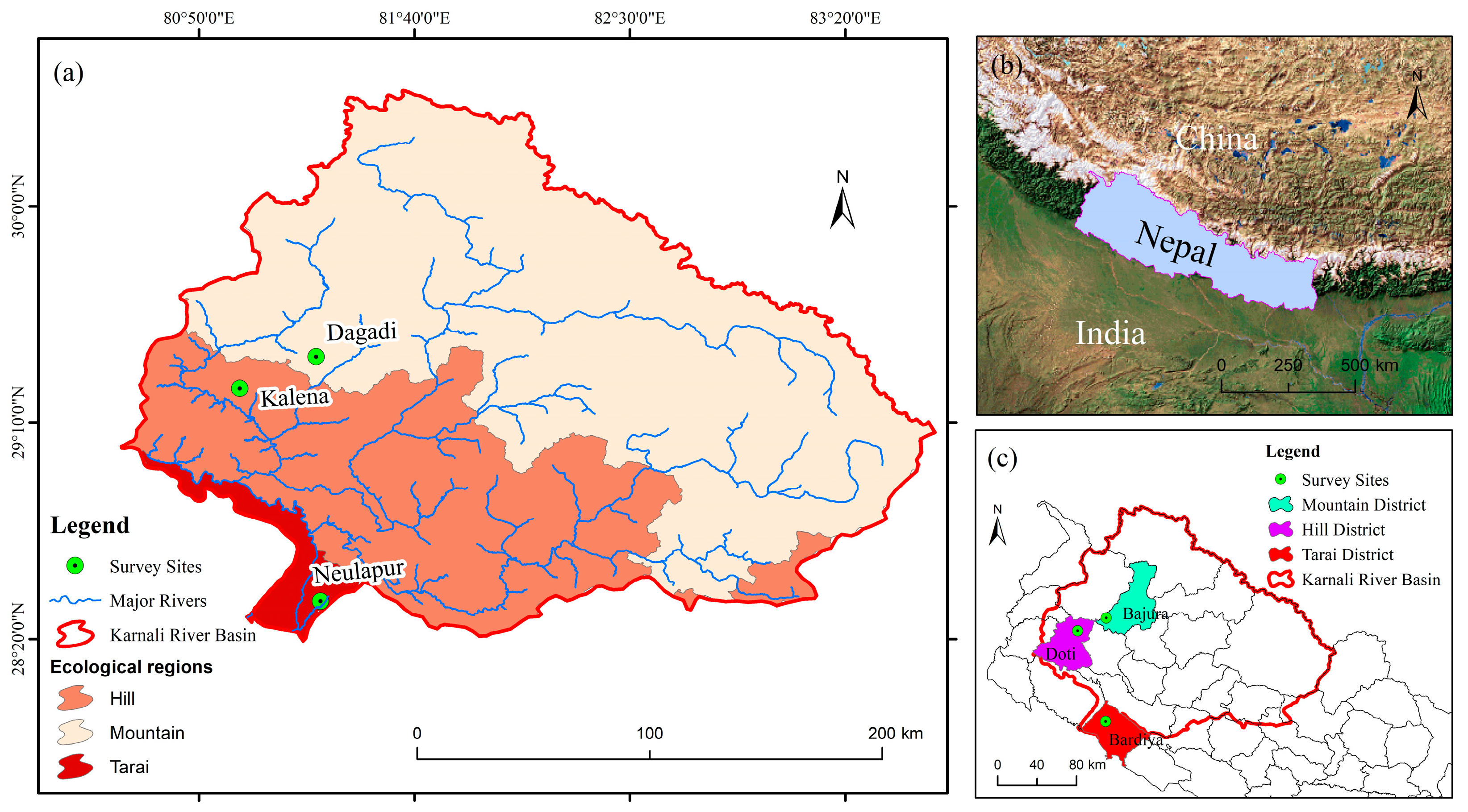
Nepal consists of three distinct ecological regions: the Mountain region in the north, the Hills in the middle, and the Tarai in the south. This work selected one representative village from each region of the Karnali Basin: Dogadi village in the Mountain region from the Bajura District, Kalena village in the Hill region from the Doti District, and Neulapur village in the Tarai region from the Bardiya District (
Figure 1). These villages are situated at different elevations (
Table 1). The variations in elevation and crops illustrate the diversity in agricultural systems across the ecological regions of the basin. These villages demonstrate additional variations in soil quality, and climatic conditions, highlighting the diverse agricultural practices found throughout Nepal [
30]. Moreover, they represent various farm sizes, production types, and levels of food self-sufficiency.
2.2. High-Resolution Satellite Image Acquisition
To explore high-accuracy farmland abandonment results at the village level in the Central Himalaya, Nepal, this work obtained GaoFen (GF-1) satellite remote-sensing images. The GaoFen satellite launched on 26 April 2013 [
32]. The satellite includes a 2 m resolution panchromatic sensor and an 8 m resolution multispectral sensor (collectively, PMS sensors) and four cameras with Wide Field of View (WFV) multispectral sensors with 16 m resolution [
33].
The swath width of the PMS sensors are 60 km and for the WFV sensors it is 800 km. The coverage revisit cycle time is 4 days. This work used the 2 m high-resolution PMS GF-1 remote-sensing satellite images obtained from the China Centre for Resources Satellite Data and Application [
34]. The details of the PMS sensor are listed in
Table 2 and the information for the satellite images is listed in
Table 3.
In addition to the 2 m GF-1 satellite remote-sensing datasets, this work also used high-resolution Google Earth images to enhance the accuracy and land-cover mapping results. The images were downloaded via the Google Map Static API [
35].
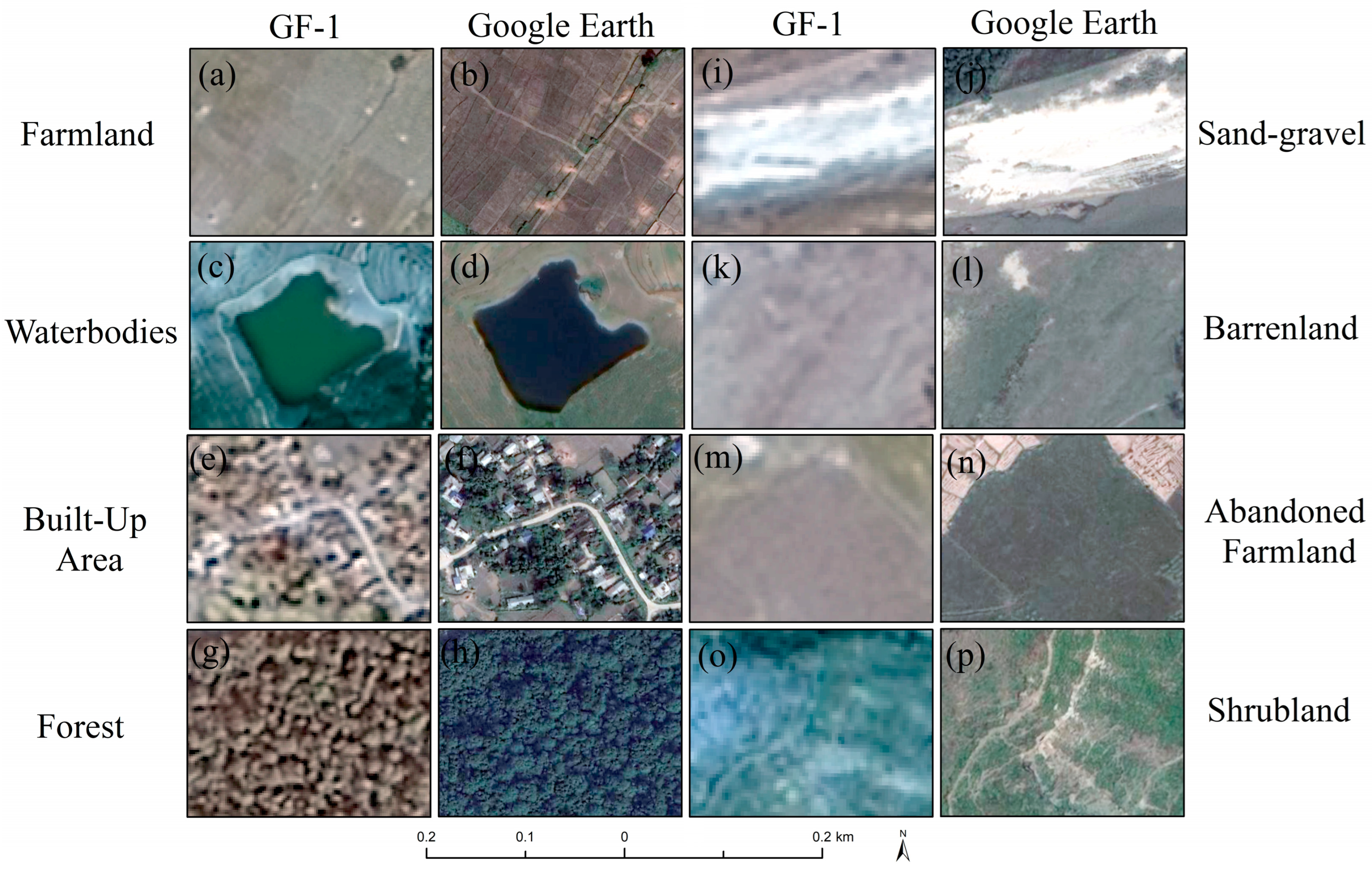
Figure 2a–p provide examples of 2 m GF-1 and high-resolution Google Earth images for various land-cover types. The high-resolution Google Earth images were freely obtained based on their center coordinates (latitude, longitude) and a specified zoom level using Google Earth software. The zoom level of 18 was applied for all high-resolution images in this work. The spatial resolution of the Google Earth images used in this work was approximately 0.14 m. This type of imagery is widely used for high-resolution land-cover mapping in different regions globally [
36]. We found that the spatial characteristics of the high-resolution Google Earth images were more distinguishable than the 2 m GF-1 imagery, particularly for identifying farmland abandonment.
2.3. Satellite Image Field Verification: A People-to-Pixel Approach
Farmland abandonment is an influential land-use change that has profound environmental and socioeconomic impacts. Accurate mapping of its occurrence and timing is essential for effective land management and policymaking. This research leverages high-resolution satellite images to detect and monitor abandoned farmlands, providing detailed spatial and temporal insights into the phenomenon.
This work applied a people-to-pixel approach to identify and map abandoned farmland including the abandonment year and status of abandoned farmland in each village. In the people-to-pixel approach, field surveys for ground truthing are conducted alongside satellite imagery, ensuring ground-truth validation and accuracy. GF-1 satellite imagery and Google Earth imagery were divided into grids in Geographic Information System (GIS) software, then exported in JPEG and TIFF format as map images. The number of grids varies based on the village area. There were 25 grids for Dogadi, Bajura; 16 grids for Kalena, Doti; and 16 grids for Neulapur, Bardiya. Both sets of map images were printed on A3 size paper for field verification.
Five people oversaw the field verifications, including the lead author of this work and four other trained field enumerators (all are geographers). The field verification was conducted in April 2024. Before the field survey, the lead author provided intensive training to the four field enumerators with demonstration field survey tools and practice sessions. The work used the freely accessible mobile application (app) Field Area Measure, which has satellite imagery in the background and is especially useful for accurate area calculations in land-cover mapping. The recorded area (point/line/polygon) and information can be exported as a shape file (.shp), which is supported by GIS software for further analysis. Printed GF-1 satellite imagery and Google Earth imagery, a Global Positioning System (GPS) receiver, tablet, and camera were used by each person, as well as a field survey record sheet for including latitude, longitude, elevation, tentative abandoned area, abandonment year, and current land-cover status. These details were recorded in the Field Area Measure app; however, the field survey sheet (
Supplementary Material Table S1) served as a backup in case of technical problems.
In the people-to-pixel approach, one person used one satellite image grid sheet for verification of each parcel. We surveyed all the active and abandoned farmland in person and recorded the details of the abandoned farmland. We took photos of the abandoned farmland from the ground during the survey, along with photos of other major land-cover types in the study area. The abandonment year of the farmland was asked of the landowner if available; if the landowner was not available, we asked nearby households or community members. Other land-cover types such as dense forest or waterbodies were observed from nearby parcels and marked on the GF-1 satellite images. If the GF-1 satellite images were unclear, we used the Google Earth images. As mentioned earlier the main objective of the work is to generate accurate information about the abandoned farmland; thus, we only recorded details of this land-cover type through the app, and all other land-cover types were marked on the GF-1 satellite imagery and later used for land-cover mapping. The detailed methodological framework is presented in
Figure 3.
2.4. Land-Cover and Abandoned Farmland Mapping
Before we started the land-cover mapping, we exported all the recorded abandoned farmland shape files of for each village from the Field Area Measure app. As mentioned earlier, the work used 2 m high-resolution GF-1 satellite imagery and 0.14 m Google Earth imagery for field verification, and the GF-1 satellite images are also used for land-cover mapping. Both these image sets are compatible with WGS 1984 Datum and do not need further georeferencing; the images can easily overlap each other.
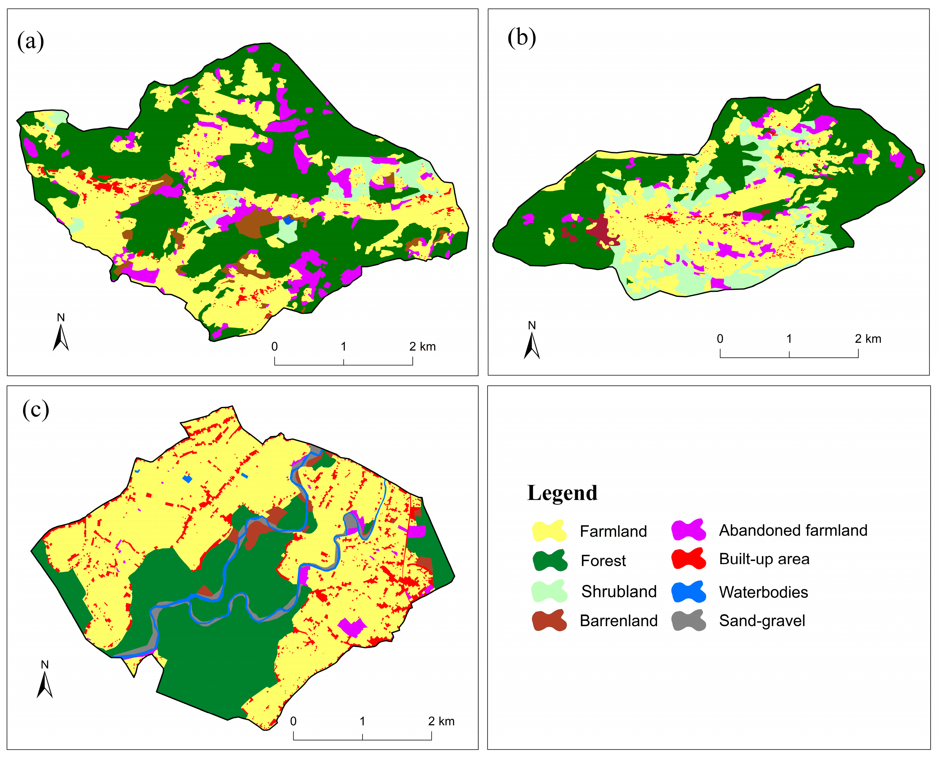
Next, the GF-1 satellite imagery of the selected villages was uploaded to the GIS and the recorded shape files of abandoned farmland were exported from the app. These are overlapped and made hollow in the software. In this way, the abandoned areas are clearly identified. Further, based on the field verification of GF-1 satellite imagery for all land-cover types, we started manual land-cover digitization using ArcGIS 10.8 (Environmental Systems Research Institute, Redlands, CA, USA). We categorized eight land-use types (
Table 4). Such manual digitization approaches have been commonly used in village-scale studies to improve accuracy [
10,
37].
Visual image interpretation is an important technique to classify and distinguish land-cover types. Thus, we digitized the land-cover types using visual image interpretation, including the land-cover types identified through field verification. The zoom view option was used in ArcGIS during the on-screen digitization for more accurate results of land-cover types in abandoned farmland. Active and abandoned farmland areas are easily identified in the high-resolution satellite images during on-screen digitization. The integration of high-resolution remote sensing and the people-to-pixel approach produced accurate abandoned farmland mapping including additional land-cover categories in three Central Himalaya villages in Nepal.
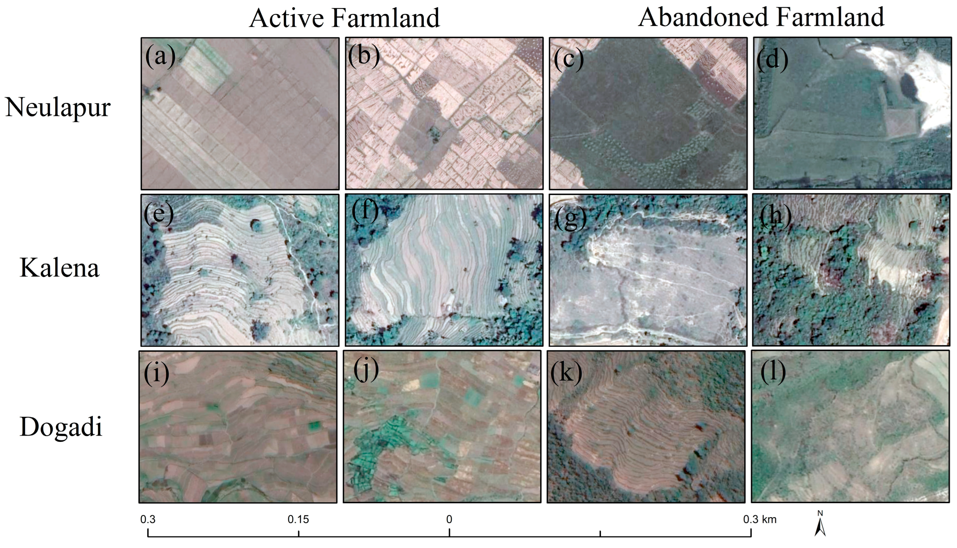
Figure 4 presents Google Earth images depicting patches of active and abandoned farmland from each village within the study area.
2.5. Data Analysis, Accuracy Assessment, and Analytical Tools
This work adopts the FAO (2016) definition of farmland abandonment, which has been cited in other farmland abandonment studies [
6,
9,
38]. For example, farmland recorded as abandoned in 2002 had been unused from 1997 to 2001 and remained abandoned at the time of the 2024 field survey. Similarly, the area marked as abandoned in 2023 had been unused from 2018 to 2022 and remained abandoned in 2024. This work does not consider pastureland to be abandoned farmland. During the people-to-pixel survey, we visited all active and abandoned farmland in person, conducting verification and recording key data such as latitude, longitude, elevation, estimated area of abandonment, the year abandonment began, and the current conditions of the abandoned farmland (weeds and grass, bushes and shrubs, woodland). When possible, we confirmed the year of abandonment directly with the landowner. If the landowner was unavailable, had migrated, or lived far from the abandoned area, we gathered this information from nearby residents or community members. If they confirmed that the land had been abandoned for more than five consecutive years and remained unused, we classified it as abandoned farmland. If not, the area was excluded.
In this work, accuracy was evaluated at two levels: with high-resolution Google Earth images and through field verification with GPS. Random points were employed to validate the classification accuracy on Google Earth. Specifically, for Neulapur, 369 stratified random points were generated, while 277 and 316 points were generated for Kalena and Dogadi, respectively (
Table 5). A total of 138, 103, and 121 GPS field verification points were collected from Neulapur, Kalena, and Dogadi, respectively.
In this work, producer’s, user’s, and overall accuracy were calculated [
39], with the overall accuracy determined using Equation (1). Producer’s accuracy (Equation (2)) refers to how well each land-cover type is classified, and user’s accuracy (Equation (3)) refers to how reliable the predicted class is. The overall accuracy refers to the percentage of total correct predictions. The Kappa coefficient (Equation (4)) accounts for random chance, providing a more robust evaluation of the model’s performance.
Kappa coefficients were employed to assess the overall accuracy [
40]. In Equation (4),
K represents the Kappa coefficient,
r refers to the number of rows and columns in the error matrix,
N indicates the total number of observations (pixels),
xii represents the observations in row
i and column
i,
xi+ is the marginal total for row
i, and
x+i is the marginal total for column
i.
This work used ArcGIS 10.8 (ESRI, Redlands, CA, USA) for on-screen digitization and mapping, analysis, and accuracy assessment of land-cover data, Holux (Holux Technology, Hsinchu, China) and Garmin (Garmin Ltd., Olathe, KS, USA) GPS to record the locations of different land-cover types, Samsung (Samsung, Suwon, Republic of Korea) tablets, the Field Area Measure mobile app (Farmis, Kaunas, Lithuania) to record details of the abandoned farmland, and Colab (Google, Woodland hills, CA USA) for data accuracy assessment.
5. Conclusions
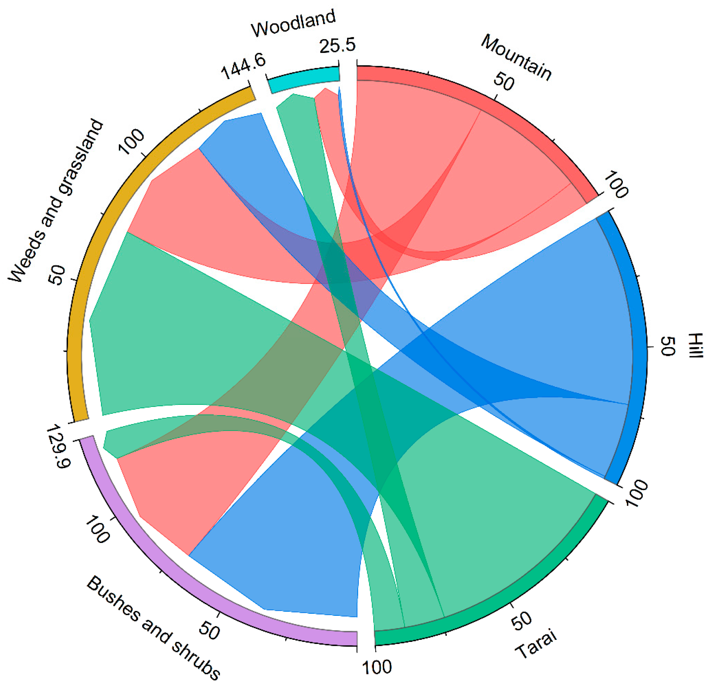
This work highlights the growing prevalence of abandoned farmland in the Karnali River Basin, Nepal, Central Himalaya, and the importance of using advanced technologies and community engagement to understand its status and vegetation succession. Using GaoFen high-resolution satellite imagery combined with a people-to-pixel approach, this work accurately identified and mapped abandoned farmland, providing valuable insights into its status. A key finding is the wide variation in farmland abandonment across different ecological regions. The Mountain region was most affected by farmland abandonment with 19.2% of the total farmland, followed by the Hill region (12.7%) and the Tarai region (2.6%). This distribution is driven by factors such as rugged terrain, limited accessibility, out-migration, and wildlife encroachment, which make farming increasingly difficult at higher altitudes. The abandonment of farmland in these areas is further influenced by rural depopulation, reduced agricultural productivity, and the growing preference for nonagricultural livelihoods.
Almost half of the abandoned farmland (49.2%) has been overtaken by bushes and shrubs, 42.9% is covered by weeds and grasses, and 7.9% has transitioned into woodlands. This work emphasizes the effectiveness of combining satellite technology with ground truthing and community participation for accurately identifying and assessing abandoned farmland. The high accuracy of the mapping (95.8%) ensures reliable data, and the involvement of local farmers and community members ensures that the data are contextually relevant. The findings have meaningful implications for land management policies in Nepal and similar regions worldwide. The detailed mapping of abandoned farmland can inform targeted interventions aimed at reversing land degradation, promoting sustainable agriculture, and supporting rural livelihoods. Policies addressing the root causes of farmland abandonment, such as out-migration and wildlife encroachment, are essential in preventing further degradation. This approach also highlights the potential for scaling up the use of satellite technology and community involvement to address farmland abandonment. This work underscores the importance of data-driven approaches to land management. Integrating satellite technology with community engagement provides a framework for developing effective strategies to combat land degradation and promote sustainable land use, contributing to the broader goals of SDG 15, which focuses on life on land and sustainable land management practices.
