Application of Structure from Motion Techniques Using Historical Aerial Images, Orthomosaics, and Aerial LiDAR Point Cloud Datasets for the Investigation of Debris Flow Source Areas
Highlights
- Structure from Motion (SfM) applied to archival aerial imagery can produce reliable 3D reconstructions in complex Italian Alpine areas when supported by careful GCP placement, high-resolution scanning, and robust co-registration.
- Multi-temporal comparison with LiDAR data revealed measurable erosion and deposition patterns linked to documented debris flow events, and visual interpretation extended the reconstruction of geomorphological changes over nearly 80 years.
- Historical aerial imagery, despite variable quality, represents a valuable resource for assessing long-term sediment dynamics and landscape evolution in data-scarce mountain environments.
- Adapting SfM workflows to archival datasets enhances hazard assessment by identifying debris flow source areas and supporting sediment transfer analysis at decadal scales.
Abstract
1. Introduction
2. Materials and Methods
2.1. Research Structure
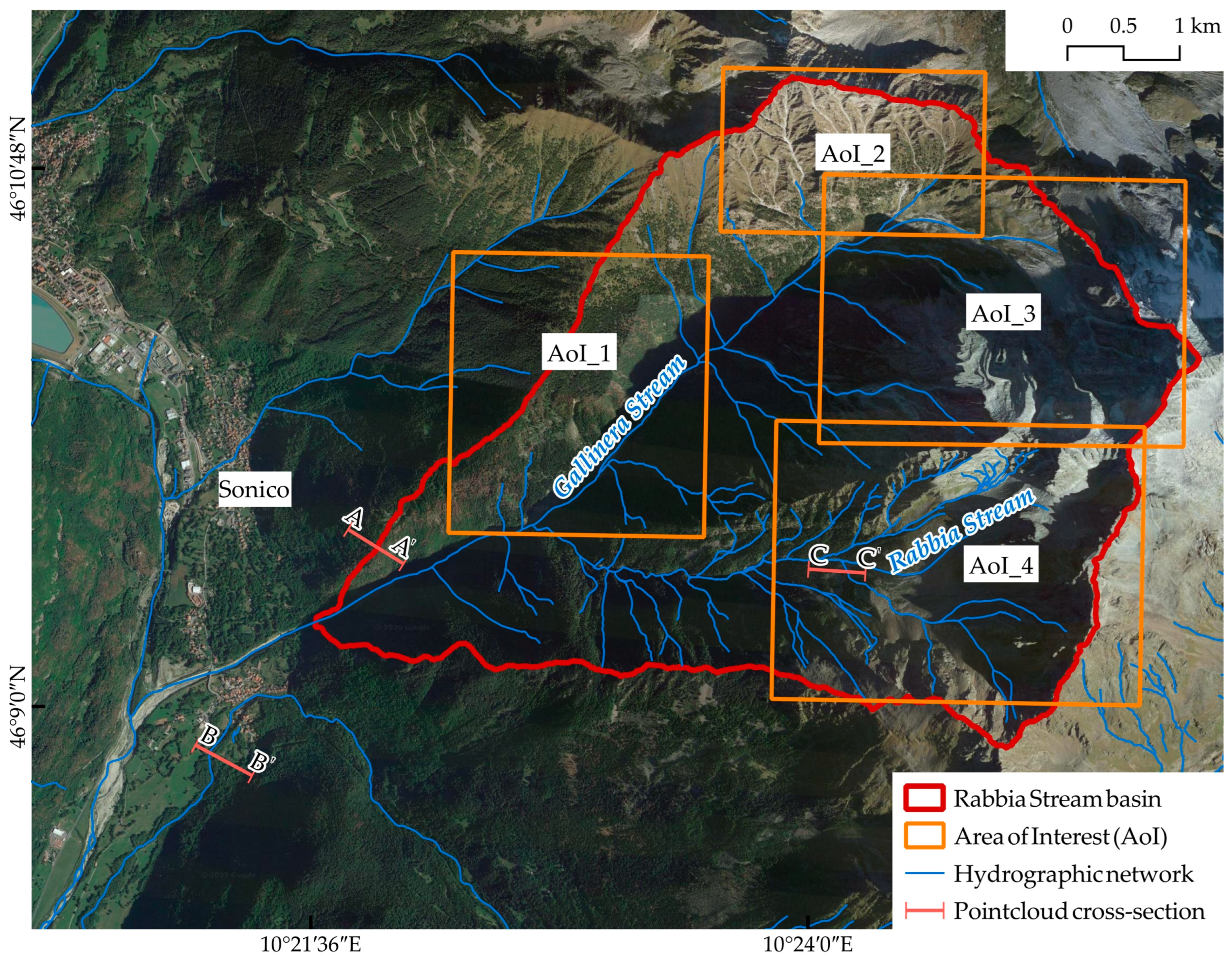
2.2. Study Area
2.3. Archival Imagery Datasets
2.4. Structure from Motion Iterative Processing and Workflow Optimisation
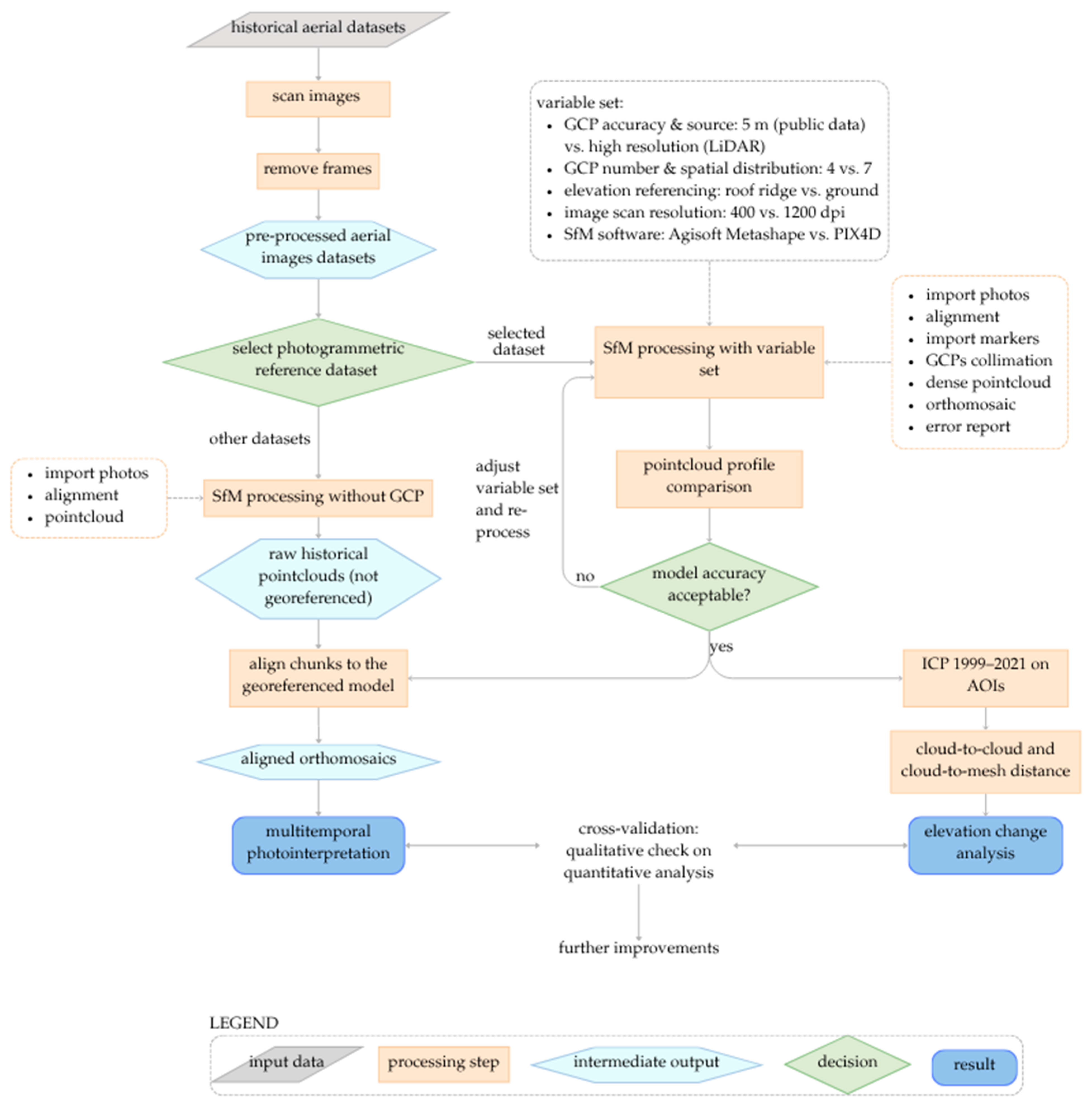
- import pre-processed photograms
- image alignment (feature detection and tie-point generation)
- camera optimisation (bundle adjustment)
- GCP import and marker collimation
- dense point cloud generation
- orthomosaic creation
- error reporting and quality assessment
2.4.1. Ground Control Points
2.4.2. Scanning Resolution
2.5. Cloud-to-Cloud and Cloud-to-Mesh Distances Between 1999 and 2021 on Areas of Interest
2.6. Qualitative Analysis
3. Results
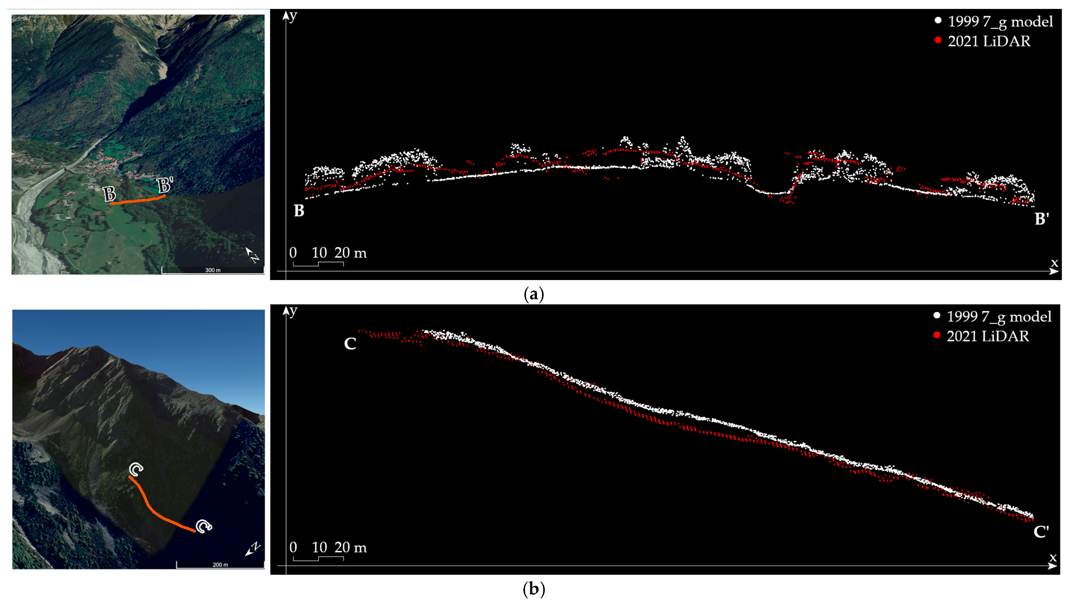
3.1. SfM Reconstruction of the 1999 Survey
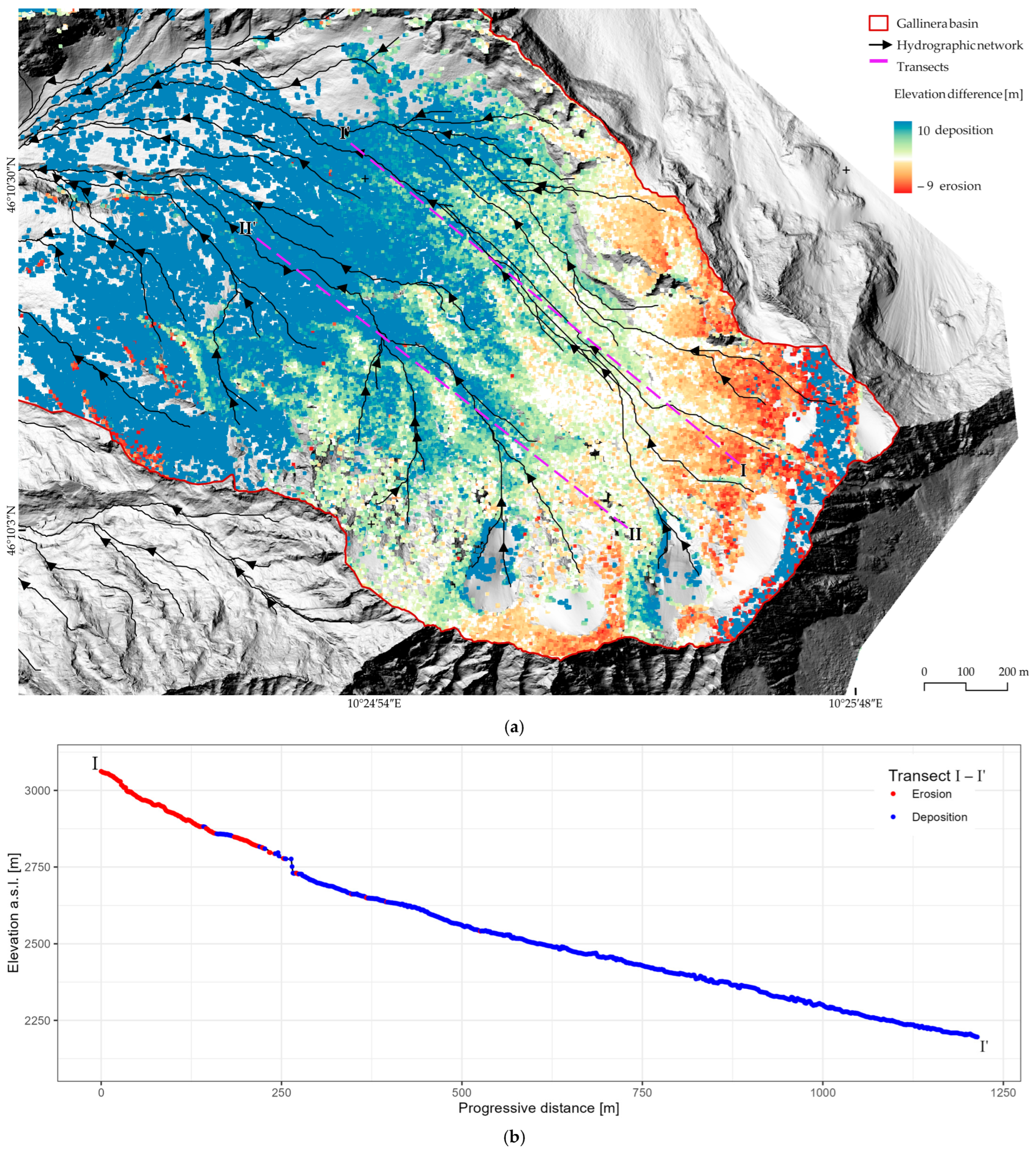
3.2. Terrain Elevation Change Analysis Between 1999 and 2021 Point Clouds
3.3. Orthomosaic Alignment and Visual Photointerpretation
4. Discussion
5. Conclusions
Author Contributions
Funding
Data Availability Statement
Acknowledgments
Conflicts of Interest
References
- Hungr, O.; McDougall, S.; Bovis, M. Entrainment of material by debris flows. In Debris-Flow Hazards and Related Phenomena; Jakob, M., Hungr, O., Eds.; Springer: Berlin/Heidelberg, Germany, 2005; pp. 135–158. [Google Scholar] [CrossRef]
- Ballesteros-Cánovas, J.A.; Stoffel, M.; de Haas, T.; Bodoque, J.M. Debris flow dating and magnitude reconstruction. In Ad-vances in Debris-flow Science and Practice; Jakob, M., McDougall, S., Santi, P., Eds.; Geoenvironmental Disaster Reduction; Springer International Publishing: Cham, Switzerland, 2024; pp. 219–248. [Google Scholar] [CrossRef]
- de Haas, T.; Lau, C.-A.; Ventra, D. Debris-flow watersheds and fans: Morphology, sedimentology and dynamics. In Advances in Debris-flow Science and Practice; Jakob, M., McDougall, S., Santi, P., Eds.; Geoenvironmental Disaster Reduction; Springer International Publishing: Cham, Germany, 2024; pp. 9–74. [Google Scholar] [CrossRef]
- Blasone, G.; Cavalli, M.; Marchi, L.; Cazorsi, F. Monitoring sediment source areas in a debris-flow catchment using terrestrial laser scanning. CATENA 2014, 123, 23–36. [Google Scholar] [CrossRef]
- Turconi, L.; Voglino, B.; Savio, G.; Tropeano, D.; Bono, B.; Luino, F. Debris flow susceptibility in a touristic alpine area: The case study of the Bardonecchia town (Upper Susa Valley, NW Italy). J. Maps 2025, 21, 2555342. [Google Scholar] [CrossRef]
- He, S.; Jiang, Y.; Ji, X. Review on the economic loss of debris flow disaster. Disasterology 2019, 34, 153–158. [Google Scholar]
- Chen, J. Research on Dynamic Risk Assessment of Debris Flow Disaster Induced by Extreme Rainfall in Mountainous Areas. Master’s Thesis, Northeast Normal University, Changchun, China, 2019. [Google Scholar]
- Tropeano, D.; Turconi, L. Geomorphic classification of alpine catchments for debris-flow hazard reduction. In Proceedings of the Debris-Flow Hazards Mitigation: Mechanics, Prediction and Assessment, Davos, Switzerland, 10–12 September 2003; Chen, C.L., Ed.; Millpress Science Publishers: Rotterdam, The Netherlands, 2003; pp. 1221–1232, ISBN 90-77017-78-X. [Google Scholar]
- Boeckli, L.; Brenning, A.; Gruber, S.; Noetzli, J. Permafrost distribution in the European Alps: Calculation and evaluation of an index map and summary statistics. Cryosphere 2012, 6, 807–820. [Google Scholar] [CrossRef]
- Nigrelli, G.; Chiarle, M. 1991–2020 climate normal in the European Alps: Focus on high-elevation environments. J. Mt. Sci. 2023, 20, 2149–2163. [Google Scholar] [CrossRef]
- Bosso, D.; Nigrelli, G.; Turconi, L.; Chiarle, M. Colate detritiche in alta quota nelle Alpi Italiane in un contesto di cambiamento climatico e degradazione della criosfera. In Proceedings of the I Fenomeni D’instabilità Naturale in Alta Montagna. La Colata Detritica del 13 Agosto 2023 a Bardonecchia: Previsione, Prevenzione e Mitigazione dei Processi (In Italian), Bardonecchia, Italy, 20–21 June 2024. [Google Scholar]
- Nigrelli, G.; Paranunzio, R.; Turconi, L.; Luino, F.; Mortara, G.; Guerini, M.; Giardino, M.; Chiarle, M. First national inventory of high-elevation mass movements in the Italian Alps. Comput. Geosci. 2024, 184, 105520. [Google Scholar] [CrossRef]
- Turconi, L.; Tropeano, D.; Savio, G.; Bono, B.; De, S.K.; Frasca, M.; Luino, F. Torrential hazard prevention in alpine small basin through historical, empirical and geomorphological cross analysis in NW Italy. Land 2022, 11, 699. [Google Scholar] [CrossRef]
- Jacob, D.; Petersen, J.; Eggert, B.; Alias, A.; Christensen, O.B.; Bouwer, L.M.; Braun, A.; Colette, A.; Déqué, M.; Georgievski, G.; et al. EURO-CORDEX: New high-resolution climate change projections for European impact research. Reg. Environ. Change 2013, 14, 563–578. [Google Scholar] [CrossRef]
- Stoffel, M.; Allen, S.K.; Ballesteros-Cánovas, J.A.; Jakob, M.; Oakley, N. Climate change effects on debris flow. In Advances in Debris-Flow Science and Practice; Jakob, M., McDougall, S., Santi, P., Eds.; Geoenvironmental Disaster Reduction; Springer International Publishing: Cham, Germany, 2024; pp. 273–308. [Google Scholar] [CrossRef]
- Kofler, C.; Mair, V.; Gruber, S.; Todisco, M.C.; Nettleton, I.; Steger, S.; Zebisch, M.; Schneiderbauer, S.; Comiti, F. When do rock glacier fronts fail? Insights from two case studies in South Tyrol (Italian Alps). Earth Surf. Proc. Landf. 2021, 46, 1311–1327. [Google Scholar] [CrossRef]
- Kang, C.; Imaizumi, F.; Theule, J. Sediment entrainment and deposition. In Advances in Debris-Flow Science and Practice; Jakob, M., McDougall, S., Santi, P., Eds.; Geoenvironmental Disaster Reduction; Springer International Publishing: Cham, Germany, 2024; pp. 165–190. [Google Scholar] [CrossRef]
- Stoffel, M.; Mendlik, T.; Schneuwly-Bollschweiler, M.; Gobiet, A. Possible impacts of climate change on debris-flow activity in the Swiss Alps. Clim. Change 2014, 122, 141–155. [Google Scholar] [CrossRef]
- Liu, W.; He, S. Comprehensive modelling of runoff-generated debris flow from formation to propagation in a catchment. Landslides 2020, 17, 1529–1544. [Google Scholar] [CrossRef]
- Chiarle, M.; Geertsema, M.; Mortara, G.; Clague, J.J. Relations between climate change and mass movement: Perspectives from the Canadian Cordillera and the European Alps. Glob. Planet. Change 2021, 202, 103499. [Google Scholar] [CrossRef]
- Jacquemart, M.; Weber, S.; Chiarle, M.; Chmiel, M.; Cicoira, A.; Corona, C.; Eckert, N.; Gaume, J.; Giacona, F.; Hirschberg, J.; et al. Detecting the impact of climate change on alpine mass movements in observational records from the European Alps. Earth-Sci. Rev. 2024, 258, 104886. [Google Scholar] [CrossRef]
- Stoffel, M.; Conus, D.; Grichting, M.A.; Lièvre, I.; Maître, G. Unraveling the patterns of late Holocene debris-flow activity on a cone in the Swiss Alps: Chronology, environment and implications for the future. Glob. Planet. Change 2008, 60, 222–234. [Google Scholar] [CrossRef]
- Messmer, M.; Simmonds, I. Global analysis of cyclone-induced compound precipitation and wind extreme events. Weather. Clim. Extremes 2021, 32, 100324. [Google Scholar] [CrossRef]
- Tuel, O.; Martius, A. A climatology of sub-seasonal temporal clustering of extreme precipitation in Switzerland and its impacts. Hydrol. Earth Syst. Sci. 2021, 21, 2949–2972. [Google Scholar] [CrossRef]
- Lehmann, J.; Coumou, D.; Frieler, K. Increased record-breaking precipitation events under global warming. Clim. Change 2015, 132, 517–518. [Google Scholar] [CrossRef]
- Rädler, A.T.; Groenemeijer, P.H.; Faust, E.; Sausen, R.; Púčik, T. Frequency of severe thunderstorms across Europe expected to increase in the 21st century due to rising instability. npj Clim. Atmos. Sci. 2019, 2, 30. [Google Scholar] [CrossRef]
- Kahraman, A.; Kendon, E.J.; Chan, S.C.; Fowler, H.J. Quasi-stationary intense rainstorms spread across Europe under climate change. Geophys. Res. Lett. 2021, 48, e2020GL092361. [Google Scholar] [CrossRef]
- Tabari, H. Climate change impact on flood and extreme precipitation increases with water availability. Sci. Rep. 2020, 10, 13768. [Google Scholar] [CrossRef] [PubMed]
- Cavalli, M.; Trevisani, S.; Comiti, F.; Marchi, L. Geomorphometric assessment of spatial sediment connectivity in small Alpine catchments. Geomorphology 2013, 188, 31–41. [Google Scholar] [CrossRef]
- Bitelli, G.; Ferrari, C.; Girelli, V.; Gusella, L.; Mognol, A.; Pezzi, G. Integrazione di immagini multitemporali aeree e satellitari per lo studio dei pattern della vegetazione nell’Appennino: Un caso di studio. In Proceedings of the Atti IX Conferenza Nazionale ASITA, Catania, Italy, 15–18 November 2005. [Google Scholar]
- Tropeano, D.; Turconi, L. Valutazione del Potenziale Detritico in Piccoli Bacini Delle Alpi Occidentali e Centrali; GNDCI: Perugia, Italy, 1999; Volume 2508, pp. 7–11, 15–26, 90–105. [Google Scholar]
- Schär, C.; Davies, T.D.; Frei, C.; Wanner, H.; Widmann, M.; Wild, M.; Davies, H. Current Alpine climate. In Views from the Alps: Regional Perspectives on Climate Change; Cebon, P., Dahinden, U., Davies, H.C., Imboden, D.M., Jäger, C., Eds.; MIT Press: Boston, MA, USA, 1998; pp. 21–72. [Google Scholar]
- Niedrist, G.H. Substantial warming of Central European mountain rivers under climate change. Reg. Environ. Change 2023, 23, 43. [Google Scholar] [CrossRef]
- Bożek, P.; Janus, J.; Mitka, B. Analysis of changes in forest structure using point clouds from historical aerial photographs. Remote Sens. 2019, 11, 2259. [Google Scholar] [CrossRef]
- Stark, M.; Rom, J.; Haas, F.; Piermattei, L.; Fleischer, F.; Altmann, M.; Becht, M. Long-term assessment of terrain changes and calculation of erosion rates in an alpine catchment based on SfM-MVS processing of historical aerial images. How camera information and processing strategy affect quantitative analysis. J. Geomorphol. 2022, 1, 43–77. [Google Scholar] [CrossRef]
- Micheletti, N.; Lane, S.N.; Chandler, J.H. Application of archival aerial photogrammetry to quantify climate forcing of alpine landscapes. Photogramm. Rec. 2015, 30, 143–165. [Google Scholar] [CrossRef]
- Del Soldato, M.; Riquelme, A.; Tomás, R.; De Vita, P.; Moretti, S. Application of Structure from Motion photogrammetry to multi-temporal geomorphological analyses: Case studies from Italy and Spain. Geogr. Fis. Din. Quat. 2018, 41, 51–66. [Google Scholar] [CrossRef]
- Cignetti, M.; Godone, D.; Wrzesniak, A.; Giordan, D. Structure from motion multisource application for landslide characterization and monitoring: The Champlas du Col Case study, Sestriere, North-Western Italy. Sensors 2019, 19, 2364. [Google Scholar] [CrossRef]
- Fototeca CNR IRPI. Available online: https://www.fototeca.to.irpi.cnr.it/fototeca/index.php (accessed on 2 April 2025).
- Natale, J.; Vitale, S.; Repola, L.; Monti, L.; Isaia, R. Geomorphic analysis of digital elevation model generated from vintage aerial photographs: A glance at the pre-urbanization morphology of the active Campi Flegrei Caldera. Geomorphology 2024, 460, 109267. [Google Scholar] [CrossRef]
- Mölg, N.; Bolch, T. Structure-from-motion using historical aerial images to analyse changes in glacier surface elevation. Remote Sens. 2017, 9, 1021. [Google Scholar] [CrossRef]
- Vargo, L.J.; Anderson, B.M.; Horgan, H.J.; Mackintosh, A.N.; Lorrey, A.M.; Thornton, M. Using structure from motion photogrammetry to measure past glacier changes from historic aerial photographs. J. Glaciol. 2017, 63, 1105–1118. [Google Scholar] [CrossRef]
- Poli, D.; Casarotto, C.; Strudl, M.; Bollmann, E.; Moe, K.; Legat, K. Use of historical aerial images for 3D modelling of glaciers in the province of Trento. Int. Arch. Photogramm. Remote Sens. Spat. Inf. Sci. 2020, 43, 1151–1158. [Google Scholar] [CrossRef]
- De Gaetani, C.I.; Ioli, F.; Pinto, L. Aerial and UAV images for photogrammetric analysis of belvedere glacier evolution in the period 1977–2019. Remote Sens. 2021, 13, 3787. [Google Scholar] [CrossRef]
- Malekian, A.; Fugazza, D.; Scaioni, M. 3D Surface Reconstruction and change detection of Miage Glacier (Italy) from multi-date Archive Aerial Photos. In Computational Science and Its Applications—ICCSA 2022 Workshops; Gervasi, O., Murgante, B., Misra, S., Rocha, A.M.A.C., Garau, C., Eds.; Springer: Cham, Spain, 2022; pp. 450–465. [Google Scholar] [CrossRef]
- Scaioni, M.; Malekian, A.; Fugazza, D. Techniques for comparing multi-temporal archive aerial imagery for glacier monitoring with poor ground control. Int. Arch. Photogramm. Remote Sens. Spatial Inf. Sci 2023, XLVIII-M-1–2023, 293–300. [Google Scholar] [CrossRef]
- Knuth, F.; Shean, D.; Bhushan, S.; Schwat, E.; Alexandrov, O.; McNeil, C.; Dehecq, A.; Florentine, C.; O’neel, S. Historical Structure from Motion (HSfM): Automated processing of historical aerial photographs for long-term topographic change analysis. Remote Sens. Environ. 2023, 285, 113379. [Google Scholar] [CrossRef]
- Genzano, N.; Fugazza, D.; Eskandari, R.; Scaioni, M. Multitemporal Structure-from-Motion: A flexible tool to cope with aerial blocks in changing mountain environment. Int. Arch. Photogramm. Remote Sens. Spat. Inf. Sci. 2024, XLVIII-2-2, 99–106. [Google Scholar] [CrossRef]
- Hughes, M.L.; McDowell, P.F.; Marcus, W.A. Accuracy assessment of georectified aerial photographs: Implications for measuring lateral channel movement in a GIS. Geomorphology 2006, 74, 1–16. [Google Scholar] [CrossRef]
- De Rose, R.C.; Basher, L.R. Measurement of river bank and cliff erosion from sequential LIDAR and historical aerial pho-tography. Geomorphology 2011, 126, 132–147. [Google Scholar] [CrossRef]
- Bakker, M.; Lane, S.N. Archival photogrammetric analysis of river–floodplain systems using Structure from Motion (SfM) methods. Earth Surf. Proc. Landf. 2016, 42, 1274–1286. [Google Scholar] [CrossRef]
- Grottoli, E.; Biausque, M.; Rogers, D.; Jackson, D.W.T.; Cooper, J.A.G. Structure-from-Motion-derived Digital Surface Models from historical aerial photographs: A new 3D application for coastal dune monitoring. Remote Sens. 2020, 13, 95. [Google Scholar] [CrossRef]
- Mestre-Runge, C.; Lorenzo-Lacruz, J.; Ortega-Mclear, A.; Garcia, C. An optimized workflow for digital surface model series generation based on historical aerial images: Testing and quality assessment in the beach-dune system of Sa Ràpita-Es Trenc (Mallorca, Spain). Remote Sens. 2023, 15, 2044. [Google Scholar] [CrossRef]
- DeWitt, J.D.; Ashland, F.X. Investigating geomorphic change using a structure from motion elevation model created from historical aerial imagery: A case study in Northern Lake Michigan, USA. ISPRS Int. J. Geo-Inf. 2023, 12, 173. [Google Scholar] [CrossRef]
- Almonacid-Caballer, J.; Cabezas-Rabadán, C.; Gorkovchuk, D.; Palomar-Vázquez, J.; Pardo-Pascual, J.E. Re-using historical aerial imagery for obtaining 3D data of beach-dune systems: A novel refinement method for producing precise and comparable DSMs. Remote Sens. 2025, 17, 594. [Google Scholar] [CrossRef]
- Conforti, M.; Mercuri, M.; Borrelli, L. Morphological changes detection of a large earthflow using archived images, LiDAR-derived DTM, and UAV-based remote sensing. Remote Sens. 2020, 13, 120. [Google Scholar] [CrossRef]
- Santangelo, M.; Zhang, L.; Rupnik, E.; Deseilligny, M.P.; Cardinali, M. Landslide evolution pattern revealed by multi-temporal DSMs obtained from historical aerial images. Int. Arch. Photogramm. Remote Sens. Spatial Inf. Sci. 2022, XLIII-B2-2022, 1085–1092. [Google Scholar] [CrossRef]
- Gomez, C.; Hayakawa, Y.; Obanawa, H. A Study of Japanese landscapes using Structure from Motion derived DSMs and DEMs based on historical aerial photographs: New opportunities for vegetation monitoring and diachronic geomorphology. Geomorphology 2015, 242, 11–20. [Google Scholar] [CrossRef]
- Westoby, M.; Brasington, J.; Glasser, N.F.; Hambrey, M.J.; Reynolds, J.M. ‘Structure-from-Motion’ photogrammetry: A low-cost, effective tool for geoscience applications. Geomorphology 2012, 179, 300–314. [Google Scholar] [CrossRef]
- Kostrzewa, A. Geoprocessing of archival aerial photos and their scientific applications: A review. Rep. Geod. Geoinform. 2024, 118, 1. [Google Scholar] [CrossRef]
- Godone, D.; Allasia, P.; Borrelli, L.; Gullà, G. UAV and Structure from Motion approach to monitor the Maierato landslide evolution. Remote Sens. 2020, 12, 1039. [Google Scholar] [CrossRef]
- Kostrzewa, A.; Farella, E.M.; Morelli, L.; Ostrowski, W.; Remondino, F.; Bakuła, K. Digitizing historical aerial images: Evaluation of the effects of scanning quality on aerial triangulation and dense image matching. Appl. Sci. 2024, 14, 3635. [Google Scholar] [CrossRef]
- Aguilar, M.A.; Aguilar, F.J.; Fernández, I.; Mills, J.P. Accuracy assessment of commercial self-calibrating bundle adjustment routines applied to archival aerial photography. Photogramm. Rec. 2013, 28, 96–114. [Google Scholar] [CrossRef]
- Colosio, P.; Marmaglio, C.; Bonomelli, R.; Ranzi, R.; the Team of debris flow monitoring and control in the Central Italian Alps. Multisensor monitoring and early warning of precipitation in mountain catchments prone to debris flow events. In Proceedings of the EGU General Assembly 2025, Vienna, Austria, 27 Apr–2 May 2025. EGU25-16231. [Google Scholar] [CrossRef]
- Agisoft Metashape Professional (Version 1.6.3) (Software). Available online: https://www.agisoft.com (accessed on 14 December 2022).
- PIX4DMapper. Available online: https://www.pix4d.com/product/pix4dmapper-photogrammetry-software/ (accessed on 2 April 2025).
- TerraScan. Available online: https://terrasolid.com/products/terrascan/ (accessed on 2 April 2025).
- Zaina, G.; Tropeano, D.; Turconi, L. Colate detritiche del luglio 2006 in alta Val Camonica (BS). Nota Prelim. GEAM 2006, 43, 25–35. [Google Scholar]
- Ricci, A. Definizione di soglie pluviometriche di allertamento per debris-flows nel bacino della Val Rabbia (Val Camonica, BS). Master’s Thesis, University of Bologna, Bologna, Italy, March 2024. [Google Scholar]
- GeSeFlu (Gestione dei Sedimenti Fluviali). Available online: https://www.irpi.cnr.it/project/geseflu/ (accessed on 2 May 2025).
- Roccati, A.; Faccini, F.; Luino, F.; Ciampalini, A.; Turconi, L. Heavy Rainfall Triggering Shallow Landslides: A susceptibility assessment by a gis-approach in a Ligurian Apennine catchment (Italy). Water 2019, 11, 605. [Google Scholar] [CrossRef]
- Studio Griffini s.r.l. Available online: http://www.studiogriffini.eu/progetti/modellazione-geotecnica-e-individuazione-soglie-criticita-nelle-zone-frana-pal-e-idro (accessed on 12 May 2025).
- Perrotti, M.; Godone, D.; Allasia, P.; Baldo, M.; Fazio, N.L.; Lollino, P. Investigating the susceptibility to failure of a rock cliff by integrating Structure-from-Motion analysis and 3D geomechanical modelling. Remote Sens. 2020, 12, 3994. [Google Scholar] [CrossRef]
- Midgley, N.G.; Tonkin, T.N. Reconstruction of former glacier surface topography from archive oblique aerial images. Geomorphology 2017, 282, 18–26. [Google Scholar] [CrossRef]
- Núñez-Andrés, M.A.; Buill, F.; Hürlimann, M.; Abancó, C. Multi-temporal analysis of morphologic changes applying geomatic techniques. 70 years of torrential activity in the Rebaixader catchment (Central pyrenees). Geomat. Nat. Hazards Risk 2018, 10, 314–335. [Google Scholar] [CrossRef]
- Geoportale Regione Lombardia. Available online: https://www.geoportale.regione.lombardia.it/ (accessed on 5 April 2025).
- Carvalho, R.C.; Kennedy, D.M.; Niyazi, Y.; Leach, C.; Konlechner, T.M.; Ierodiaconou, D. Structure-from-motion photogrammetry analysis of historical aerial photography: Determining beach volumetric change over decadal scales. Earth Surf. Proc. Landf. 2020, 45, 2540–2555. [Google Scholar] [CrossRef]
- Tian, Y.; Xia, M.; An, L.; Scaioni, M.; Li, R. Innovative method of combing multidecade remote sensing data for detecting precollapse elevation changes of glaciers in the Larsen B Region, Antarctica. IEEE J. Sel. Top. Appl. Earth Obs. Remote Sens. 2022, 15, 9699–9715. [Google Scholar] [CrossRef]
- Paliaga, G.; Luino, F.; Turconi, L.; Profeta, M.; Vojinovic, Z.; Cucchiaro, S.; Faccini, F. Terraced landscapes as NBSs for geo-hydrological hazard mitigation: Towards a methodology for debris and soil volume estimations through a LiDAR survey. Remote Sens. 2022, 14, 3586. [Google Scholar] [CrossRef]
- Rault, C.; Dewez, T.J.B.; Aunay, B. Structure-from-Motion processing of aerial archive photographs: Sensitivity analyses pave the way for quantifying geomorphological changes since 1978 in La Réunion Island. ISPRS Ann. Photogramm. Remote Sens. Spatial Inf. Sci. 2020, V-2–2020, 773–780. [Google Scholar] [CrossRef]
- Seccaroni, S.; Santangelo, M.; Marchesini, I.; Mondini, A.C.; Cardinali, M. High resolution historical topography: Getting more from archival aerial photographs. In Proceedings of the 2nd International Electronic Conference on Remote Sensing, Basel, Switzerland, 22 March 2018. [Google Scholar]
- Lipwoni, V.; Watt, M.S.; Hartley, R.J.L.; Leonardo, E.M.C.; Morgenroth, J. A comparison of photogrammetric software for deriving Structure-from-Motion 3D point clouds and estimating tree heights. NZJ For. Sci. 2022, 66, 18–26. [Google Scholar]
- Mora-Félix, Z.D.; Rangel-Peraza, J.G.; Monjardín-Armenta, S.A.; Sanhouse-García, A.J. Performance and precision analysis of 3D surface modeling through UAVs: Validation and comparison of different photogrammetric data processing software. Phys. Scr. 2024, 99, 035017. [Google Scholar] [CrossRef]
- Eltner, A.; Kaiser, A.; Castillo, C.; Rock, G.; Neugirg, F.; Abellán, A. Image-based surface reconstruction in geomorphometry—Merits, limits and developments. Earth Surf. Dyn. 2016, 4, 359–389. [Google Scholar] [CrossRef]
- Malekian, A.; Fugazza, D.; Scaioni, M. Photogrammetric reconstruction and multi-temporal comparison of Brenva Glacier (Italy) from archive photos. Photogramm. Remote Sens. Spatial Inf. Sci. 2023, X-4/W1-2022, 459–466. [Google Scholar] [CrossRef]
- Besl, P.; McKay, H. A method for registration of 3-D shapes. IEEE Trans. Pattern. Anal. Mach. Intell. 1992, 14, 239–256. [Google Scholar] [CrossRef]
- Turconi, L.; De, S.K.; Tropeano, D.; Savio, G. Slope failure and related processes in the Mt. Rocciamelone area (Cenischia Valley, Western Italian Alps). Geomorphology 2010, 114, 115–128. [Google Scholar] [CrossRef]
- Lane, S.N.; James, T.D.; Crowell, M.D. Application of digital photogrammetry to complex topography for geomorphological research. Photogramm. Rec. 2000, 16, 793–821. [Google Scholar] [CrossRef]
- Pulighe, G.; Fava, F. DEM extraction from archive aerial photos: Accuracy assessment in areas of complex topography. Eur. J. Remote Sens. 2013, 46, 363–378. [Google Scholar] [CrossRef]
- Sanz-Ablanedo, E.; Chandler, J.H.; Rodríguez-Pérez, J.R.; Ordóñez, C. Accuracy of Unmanned Aerial Vehicle (UAV) and SfM photogrammetry survey as a function of the number and location of Ground Control Points used. Remote Sens. 2018, 10, 1606. [Google Scholar] [CrossRef]
- Cucchiaro, S.; Maset, E.; Cavalli, M.; Crema, S.; Marchi, L.; Beinat, A.; Cazorzi, F. How does co-registration affect geomorphic change estimates in multi-temporal surveys? GIScience Remote Sens 2020, 57, 611–632. [Google Scholar] [CrossRef]
- Giordano, S.; Le Bris, A.; Mallet, C. Toward automatic georeferencing of archival aerial photogrammetric surveys. Photogramm. Remote Sens. Spatial Inf. Sci. 2018, IV–2, 105–112. [Google Scholar] [CrossRef]
- Pinto, A.T.; Gonçalves, J.A.; Beja, P.; Pradinho Honrado, J. From archived historical aerial imagery to informative orthophotos: A framework for retrieving the past in long-term socioecological research. Remote Sens. 2019, 11, 1388. [Google Scholar] [CrossRef]
- Luman, D.E. Digital Reproduction of Historical Aerial Photographic Prints for Preserving a Deteriorating Archive. Photogramm. Eng. Remote Sensing 1997, 63, 1171–1179. [Google Scholar]
- Cavalli, M.; Goldin, B.; Comiti, F.; Brardinoni, F.; Marchi, L. Assessment of erosion and deposition in steep mountain basins by differencing sequential digital terrain models. Geomorphology 2017, 291, 4–16. [Google Scholar] [CrossRef]
- Eltner, A.; Sofia, G. Chapter 1—Structure from Motion Photogrammetric Technique. In Developments in Earth Surface Processes; Tarolli, P., Mudd, S.M., Eds.; Elsevier: Amsterdam, The Netherlands, 2020; Volume 23, pp. 1–24. ISBN 0928-2025. [Google Scholar] [CrossRef]
- Cucchiaro, S.; Cavalli, M.; Vericat, D.; Crema, S.; Llena, M.; Beinat, A.; Marchi, L.; Cazorzi, F. Monitoring topographic changes through 4D-structure-from-motion photogrammetry: Application to a debris-flow channel. Environ. Earth Sci. 2018, 77, 632. [Google Scholar] [CrossRef]
- Craciun, D.; Le Bris, A. Automatic algorithm for georeferencing historical-to-nowadays aerial images acquired in natural environments. Int. Arch. Photogramm. Remote Sens. Spatial Inf. Sci. 2022, XLIII-B2-2022, 21–28. [Google Scholar] [CrossRef]
- Feurer, D.; Vinatier, F. Joining multi-epoch archival aerial images in a single SfM block allows 3-D change detection with almost exclusively image information. ISPRS J. Photogramm. Remote Sens. 2018, 146, 495–506. [Google Scholar] [CrossRef]
- Salach, A. SAPC—Application for adapting scanned analogue photographs to use them in structure from motion technology. Int. Arch. Photogramm. Remote Sens. Spatial Inf. Sci. 2017, XLII-1/W1, 197–204. [Google Scholar] [CrossRef]
- Zhang, L.; Rupnik, E.; Pierrot-Deseilligny, M. Feature matching for multi-epoch historical aerial images. ISPRS J. Photogramm. Remote Sens. 2021, 182, 176–189. [Google Scholar] [CrossRef]
- Maiwald, F.; Feurer, D.; Eltner, A. Solving photogrammetric cold cases using AI-based image matching: New potential for monitoring the past with historical aerial images. ISPRS J. Photogramm. Remote Sens. 2023, 206, 184–200. [Google Scholar] [CrossRef]
- James, M.R.; Chandler, J.H.; Eltner, A.; Fraser, C.; Miller, P.E.; Mills, J.P.; Noble, T.; Robson, S.; Lane, S.N. Guidelines on the use of structure-from-motion photogrammetry in geomorphic research. Earth Surf. Proc. Landf. 2019, 44, 2081–2084. [Google Scholar] [CrossRef]
- Hong, X.; Roosevelt, C.H. Orthorectification of large datasets of multi-scale archival aerial imagery: A case study from Türkiye. J. Geovisualization Spat. Anal. 2023, 7, 23. [Google Scholar] [CrossRef]
- Morino, C.; Conway, S.J.; Balme, M.R.; Hillier, J.; Jordan, C.; Sæmundsson, Þ.; Argles, T. Debris-flow release processes in-vestigated through the analysis of multi-temporal LiDAR datasets in North-western Iceland. Earth Surf. Proc. Landf. 2019, 44, 144–159. [Google Scholar] [CrossRef]



| Year | Month | Day |
|---|---|---|
| 1757 | 08 | 30–31 |
| 1765 | 07 | - |
| 1825 | 08 | 05 |
| 1828 | 09 | 13–14 |
| 1829 | 08 | - |
| 1839 | 09 | 02 |
| 1850 | 08 | 14–15 |
| 1869 | 09 | 11 |
| 1882 | 09 | 15 |
| 1885 | - | - |
| 1911 | 08 | - |
| 1952 | 10 | 26 |
| 1953 | 07 | - |
| 1936 | 08 | - |
| 1960 | 09 | 17–20 |
| 1985 | 08 | 25–26 |
| 1987 | 07 | 18 |
| 1987 | 08 | 24–25 |
| 1987 | 09 | 26 |
| 1991 | 07 | 5–6 |
| 1999 | 10 | 07 |
| 2006 | 10 | 15 |
| 2006 | 07 | 24 |
| 2006 | 07 | 31 |
| 2012 | 07 | 27 |
| 2013 | 10 | 24 |
| 2018 | 08 | 5–6 |
| 2020 | 08 | 29 |
| 2023 | 08 | 27 |
| Date | Flight Name | Number of Selected Photograms | Flight Altitude [m] | Panchromatic or RGB |
|---|---|---|---|---|
| 31 August 1935 | F. 19 Tirano | 18 | 5800 | Panchromatic |
| 2 October 1954 | F. 19 Tirano | 7 | 10,000 | Panchromatic |
| 27 August 1961 | F. Tirano 1961 | 22 | 5200 | Panchromatic |
| late summer 1975 | Prov. Brescia 1975 | 14 | N.D. | Panchromatic |
| 18 September 1983 | F. 19 Tirano 1981–1983 | 13 | 5700 | RGB |
| 27 July 1991 | F. 19 Tirano | 12 | 7750 | Panchromatic |
| 2 October 1999 | Volo IT 2000 | 8 | 8500 | RGB |
| Aspect | Variable | Value |
|---|---|---|
| GCP for absolute accuracy | Source and accuracy GCP and spatial distribution Elevation definition | Dataset 5 m LiDAR high-resolution 4 7 roof ridge ground |
| Image dpi for geometric details | Scanning resolution | 400 dpi/1200 dpi |
| Optimisation algorithms | Software | Agisoft Metashape [52] PIX4Dmapper [53] |
| Point Cloud Name | GCP Number | Elevation Referencing | X Error (m) | Y Error (m) | Z Error (m) | XY Error (m) | Total RMSE (m) |
|---|---|---|---|---|---|---|---|
| 4_r | 4 | Roof ridge | 0.58 | 1.5 | 2.23 | 1.61 | 2.76 |
| 4_g | 4 | Ground | 0.36 | 1.37 | 2.06 | 1.41 | 2.51 |
| 7_g | 7 | Ground | 0.73 | 0.89 | 1.71 | 1.16 | 2.07 |
Disclaimer/Publisher’s Note: The statements, opinions and data contained in all publications are solely those of the individual author(s) and contributor(s) and not of MDPI and/or the editor(s). MDPI and/or the editor(s) disclaim responsibility for any injury to people or property resulting from any ideas, methods, instructions or products referred to in the content. |
© 2025 by the authors. Licensee MDPI, Basel, Switzerland. This article is an open access article distributed under the terms and conditions of the Creative Commons Attribution (CC BY) license (https://creativecommons.org/licenses/by/4.0/).
Share and Cite
Voglino, B.; Godone, D.; Baldo, M.; Bono, B.; Luino, F.; Bonomelli, R.; Colosio, P.; Beretta, L.; Albertelli, L.; Turconi, L. Application of Structure from Motion Techniques Using Historical Aerial Images, Orthomosaics, and Aerial LiDAR Point Cloud Datasets for the Investigation of Debris Flow Source Areas. Remote Sens. 2025, 17, 3658. https://doi.org/10.3390/rs17223658
Voglino B, Godone D, Baldo M, Bono B, Luino F, Bonomelli R, Colosio P, Beretta L, Albertelli L, Turconi L. Application of Structure from Motion Techniques Using Historical Aerial Images, Orthomosaics, and Aerial LiDAR Point Cloud Datasets for the Investigation of Debris Flow Source Areas. Remote Sensing. 2025; 17(22):3658. https://doi.org/10.3390/rs17223658
Chicago/Turabian StyleVoglino, Bianca, Danilo Godone, Marco Baldo, Barbara Bono, Fabio Luino, Riccardo Bonomelli, Paolo Colosio, Luca Beretta, Luca Albertelli, and Laura Turconi. 2025. "Application of Structure from Motion Techniques Using Historical Aerial Images, Orthomosaics, and Aerial LiDAR Point Cloud Datasets for the Investigation of Debris Flow Source Areas" Remote Sensing 17, no. 22: 3658. https://doi.org/10.3390/rs17223658
APA StyleVoglino, B., Godone, D., Baldo, M., Bono, B., Luino, F., Bonomelli, R., Colosio, P., Beretta, L., Albertelli, L., & Turconi, L. (2025). Application of Structure from Motion Techniques Using Historical Aerial Images, Orthomosaics, and Aerial LiDAR Point Cloud Datasets for the Investigation of Debris Flow Source Areas. Remote Sensing, 17(22), 3658. https://doi.org/10.3390/rs17223658


