A Study on the Identification of Geohazards in Henan Province Based on the Basic Deformation Products of LuTan-1
Highlights
- First province-scale geohazard identification using LuTan-1 InSAR products.
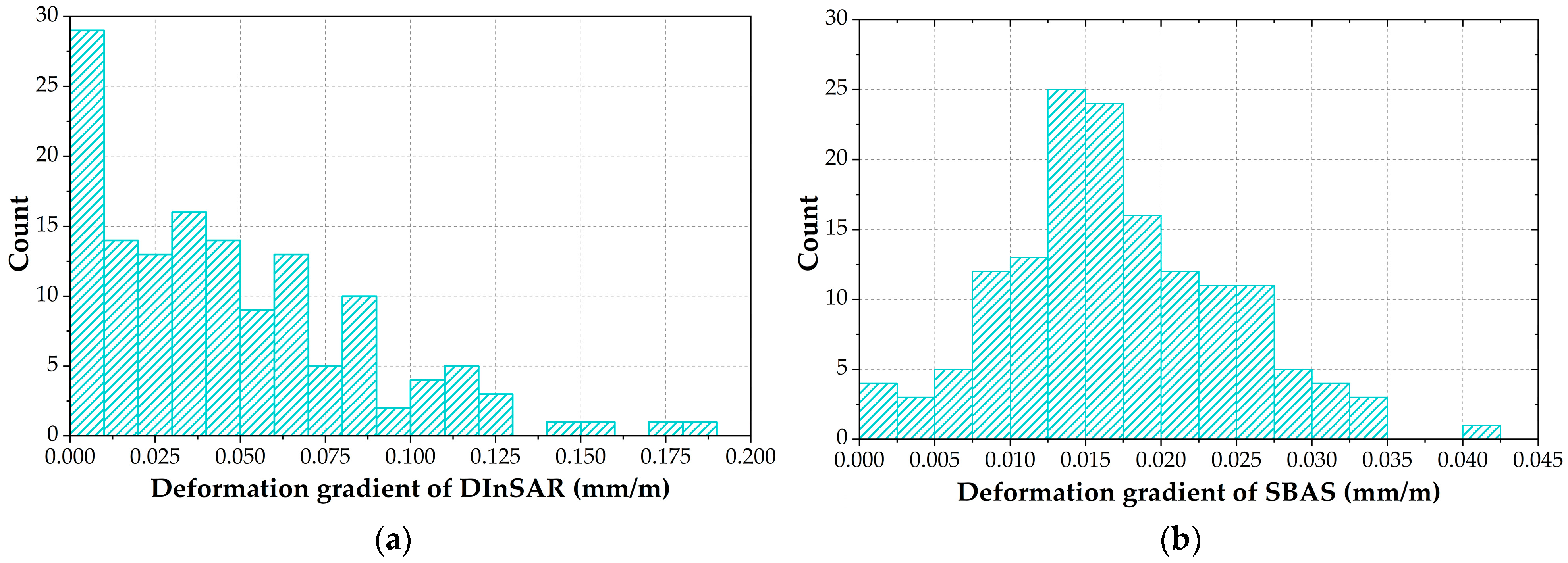
- Determining the minimum detectable deformation gradients for DInSAR and SBAS.
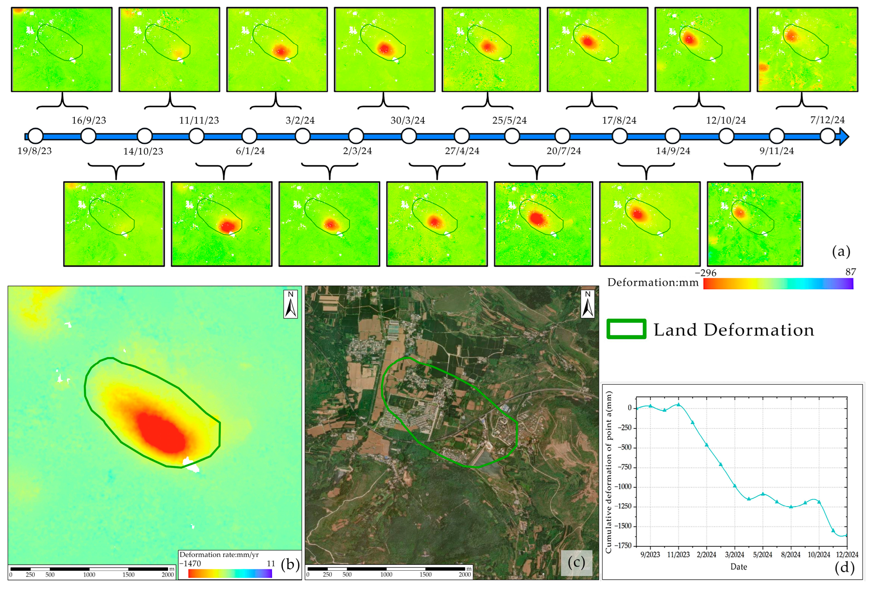
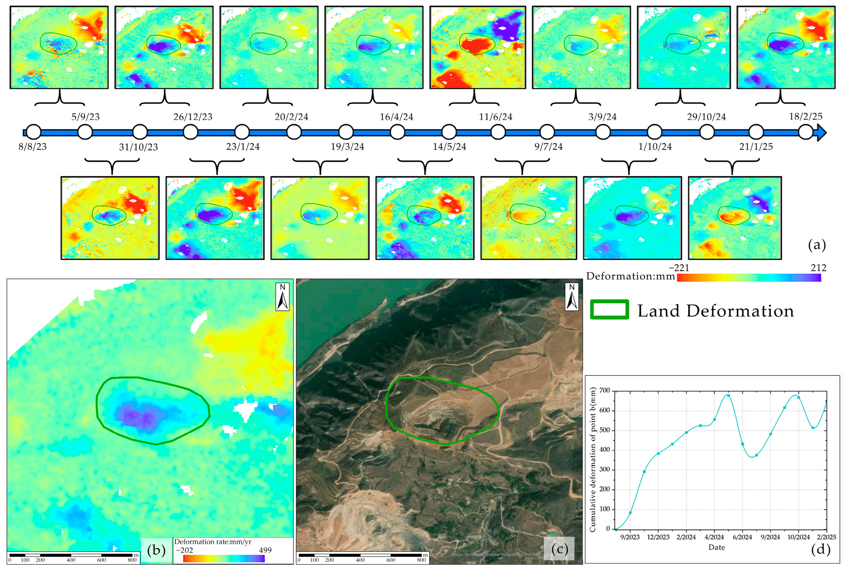
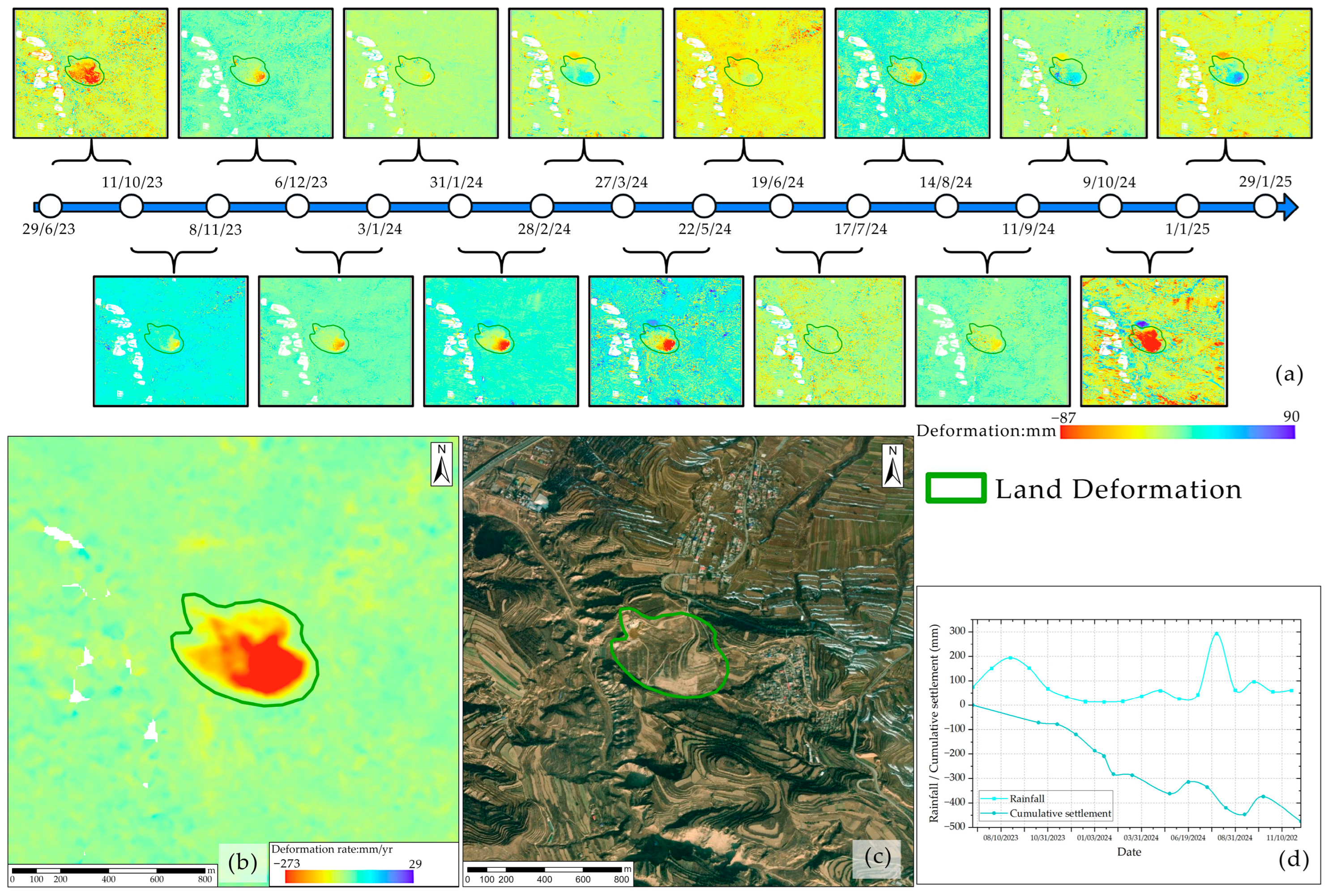
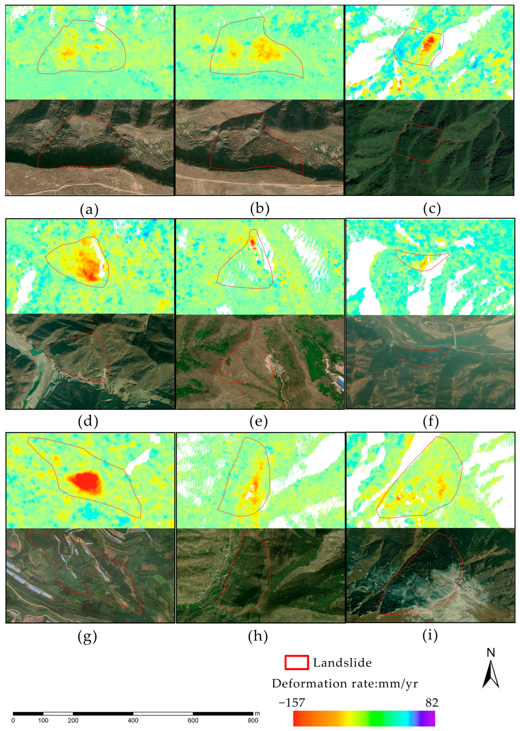
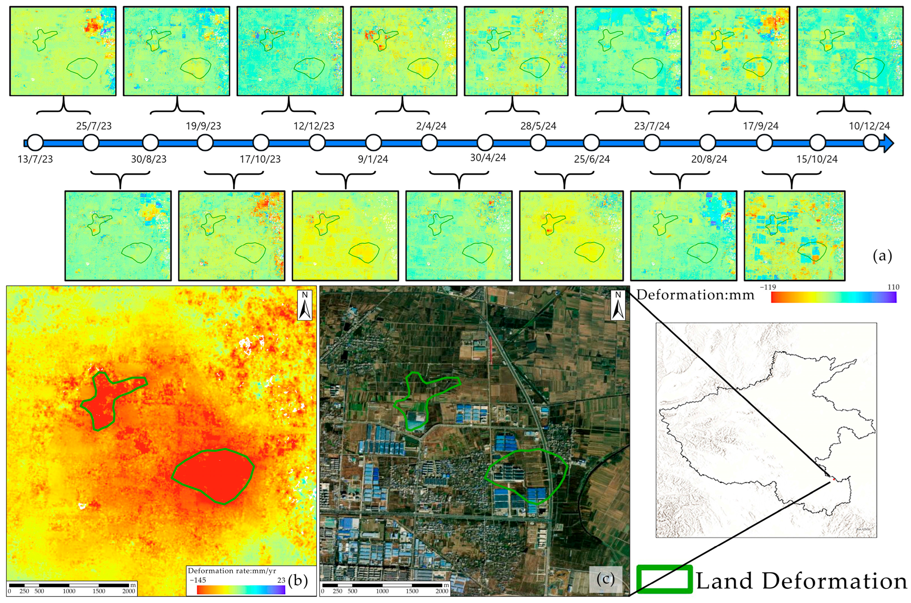
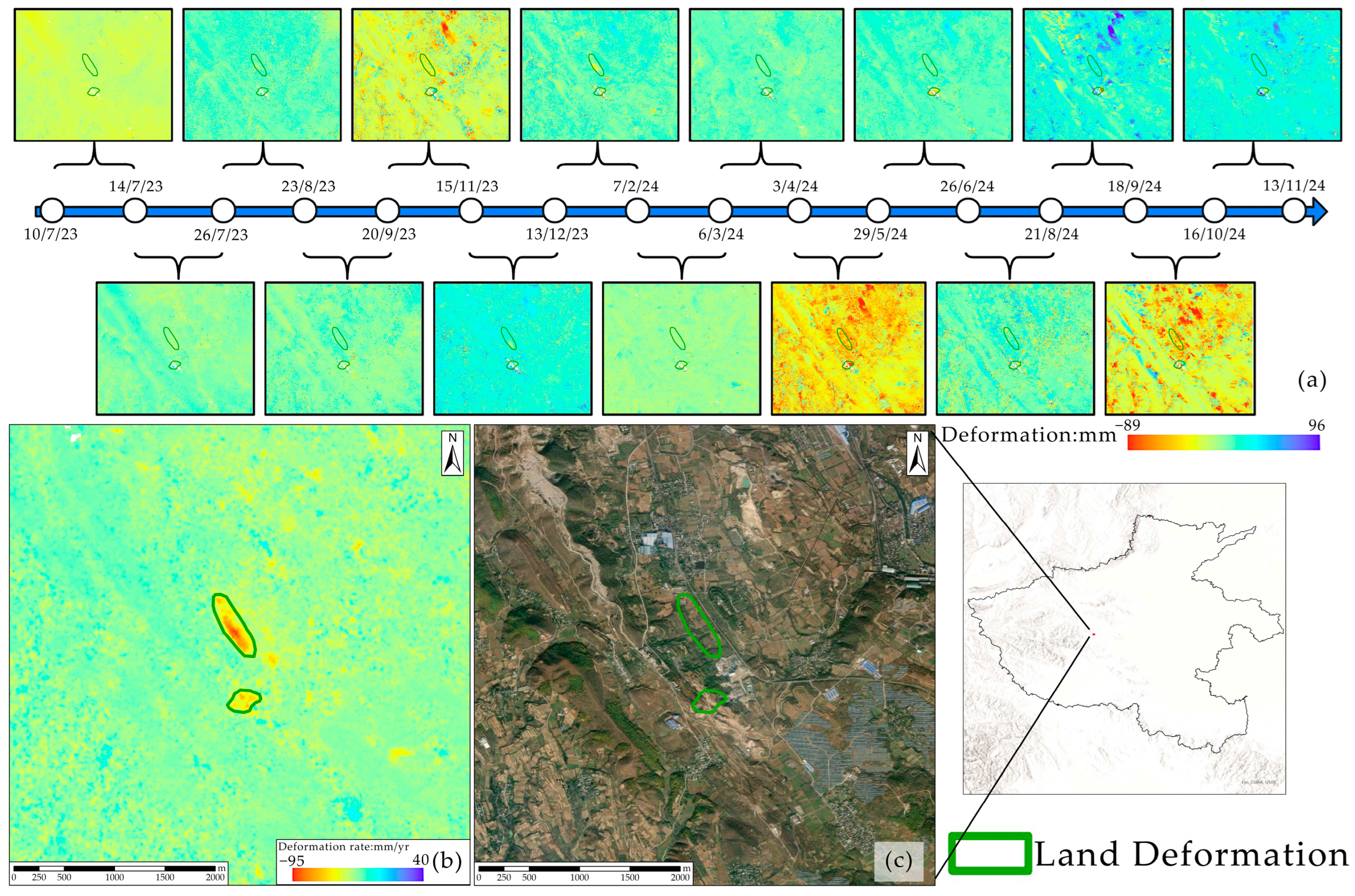
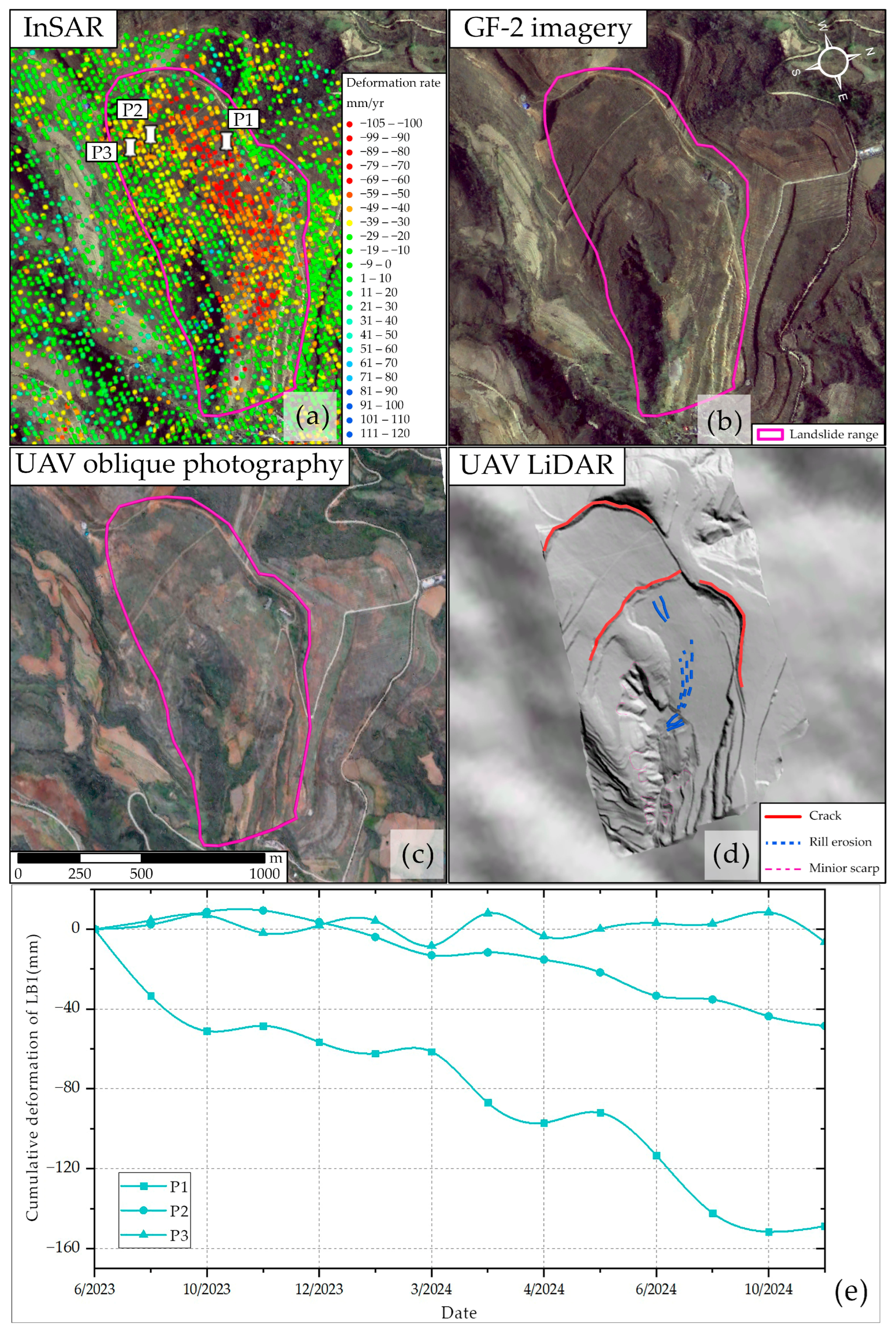
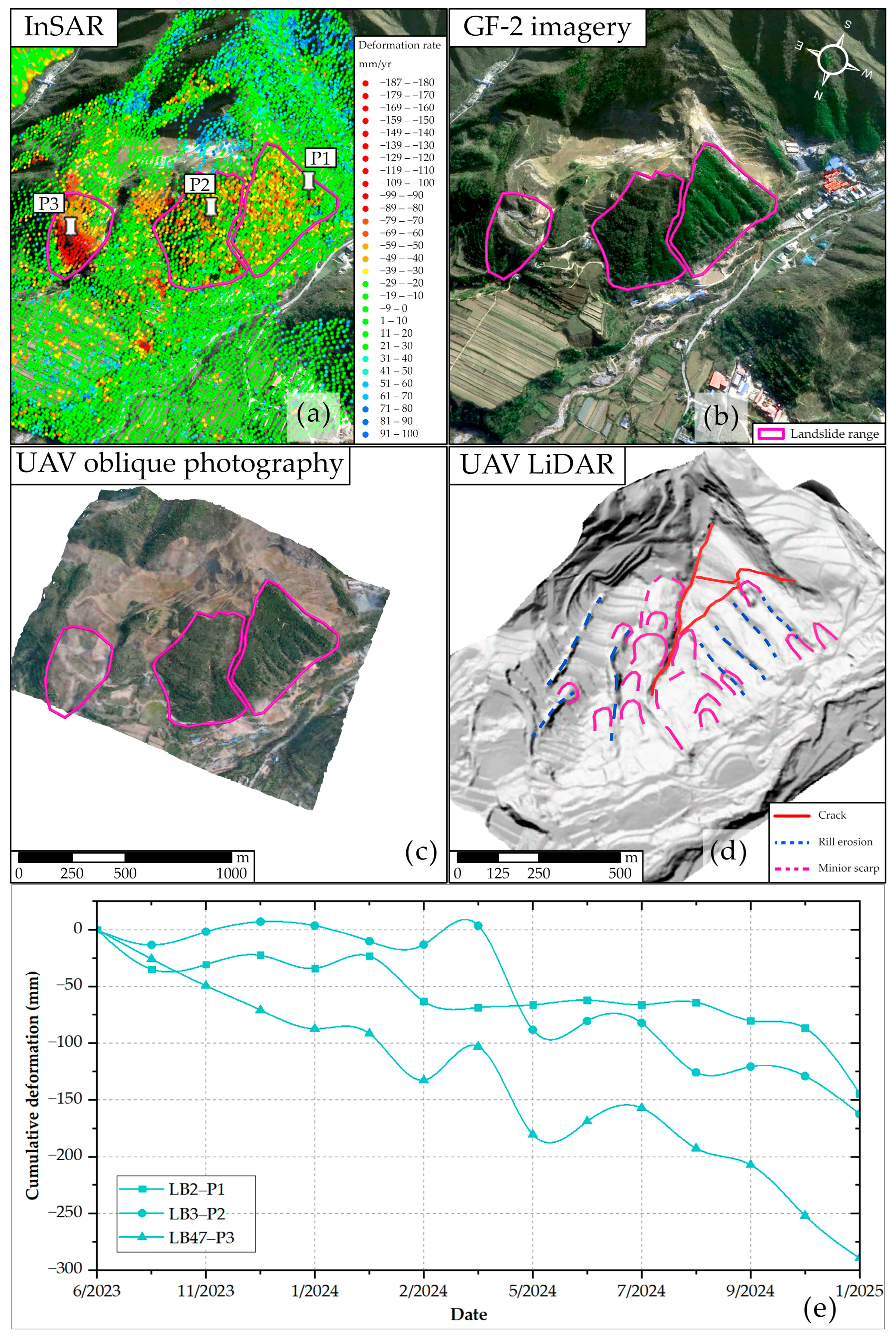
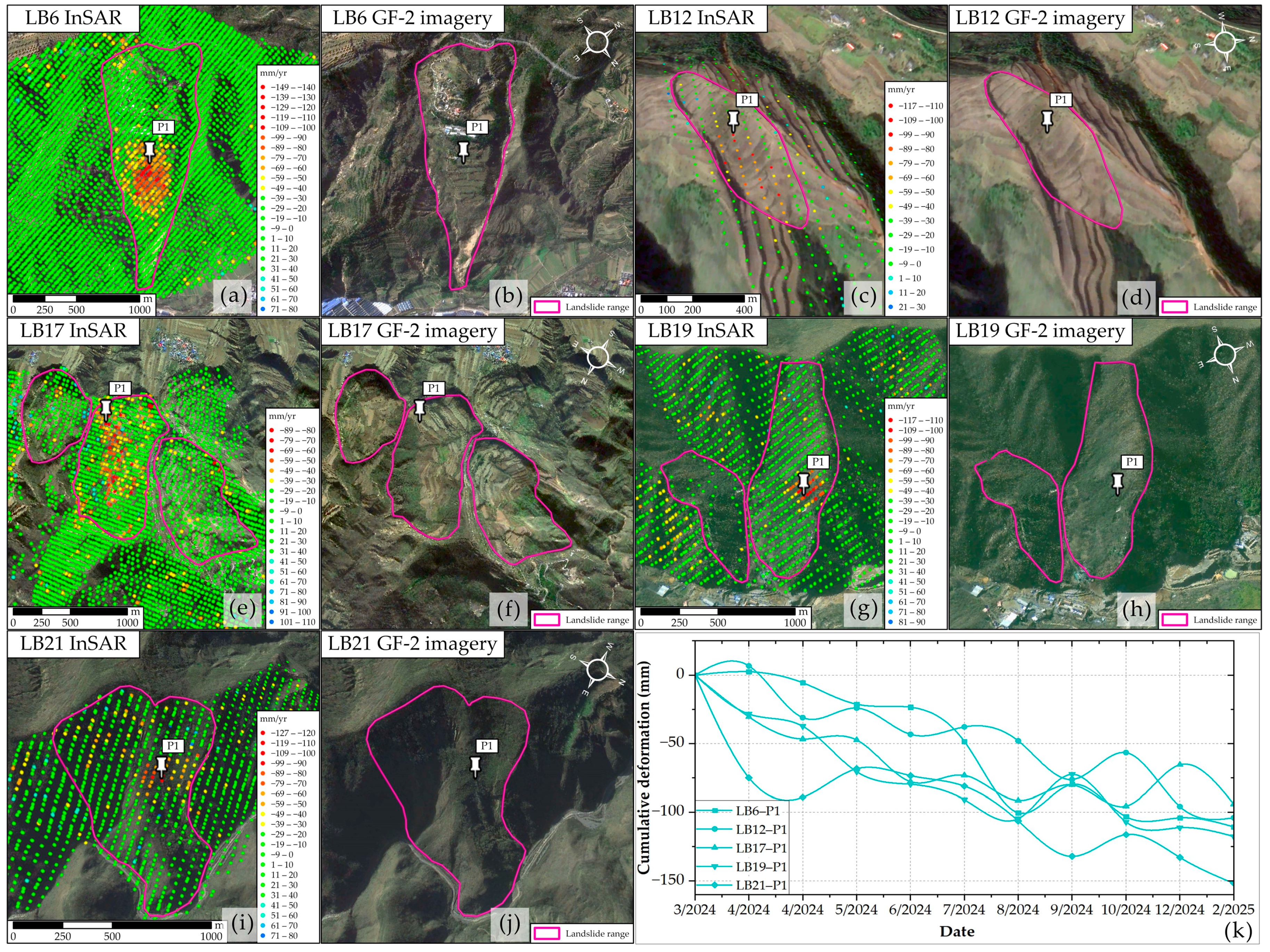
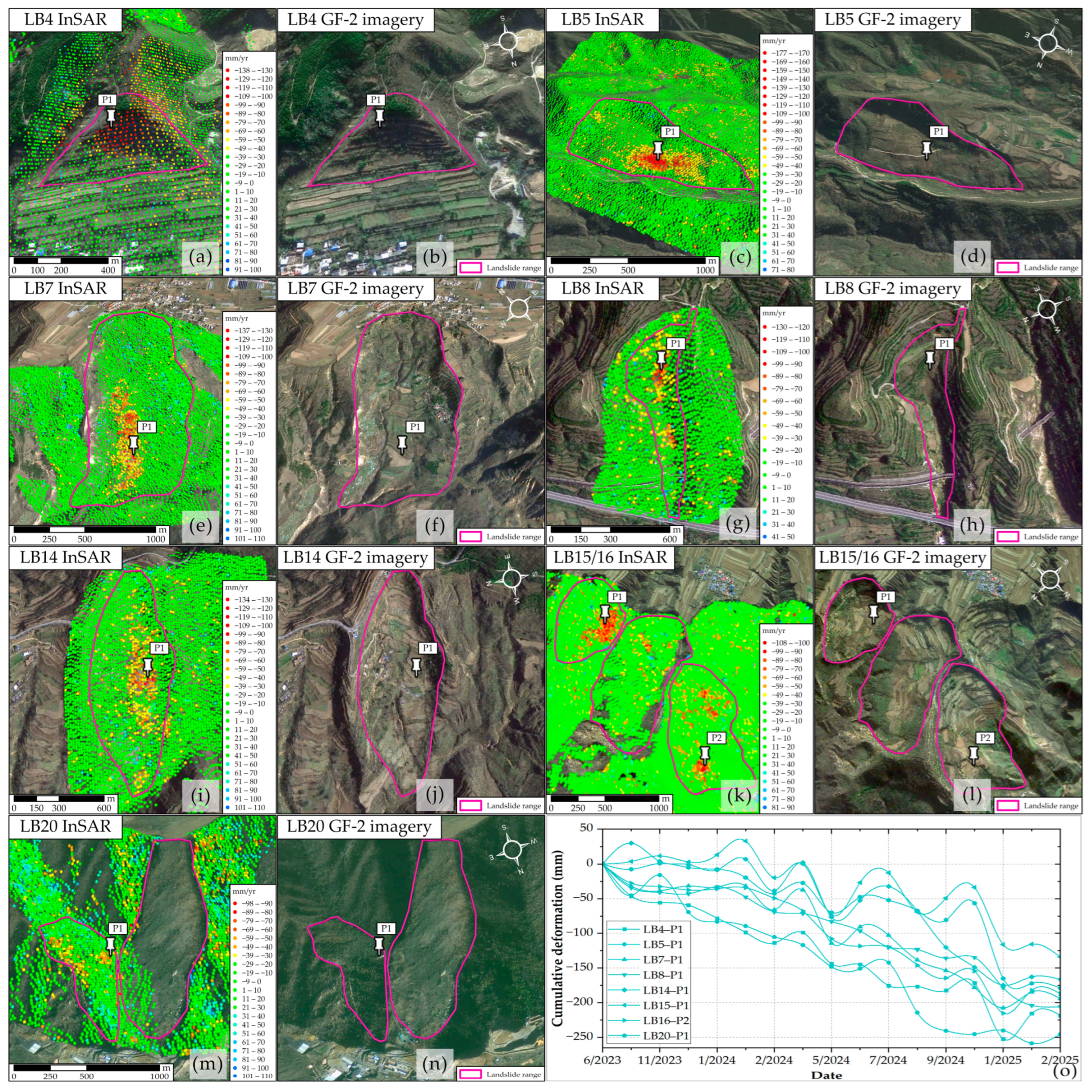
- We found 1620 geohazards across Henan Province, proving the applicability of LuTan-1 SAR products in geohazard detection for wide areas.
- SBAS obtained smaller minimum detectable deformation gradients for Henan, proving that it’s more usable for deformation monitoring. But DInSAR is better when the coherence is higher than 0.6.
Abstract
1. Introduction
2. Materials and Methods
2.1. Study Area
2.2. Datasets
2.3. Production Methods and Minimum Detectable Deformation Velocity Gradients
3. Results
4. Discussion
4.1. Detailed Investigation of Typical Geohazards
4.2. The Minimum Detectable Deformation Gradients of DInSAR and SBAS
5. Conclusions
Author Contributions
Funding
Data Availability Statement
Acknowledgments
Conflicts of Interest
References
- Henan Provincial Department of Land and Resources. The 13th Five-Year Plan for Geological Disaster Prevention and Control in Henan Province. Available online: http://hn.cnr.cn/tbgz/20170719/t20170719_523857086.shtml (accessed on 4 September 2025).
- Zhang, Y.; Ci, H.; Yang, H.; Wang, R.; Yan, Z. Rainfall-Induced Geological Hazand Susceptibility Assessmentin the Henan Section ofthe Yellow River Basin: Multi-Model Approaches Supporting Disaster Mitigation and Sustainable Development. Sustainability 2025, 17, 4348. [Google Scholar] [CrossRef]
- Tang, X.; Li, T.; Chen, J.; Wei, C.; Zhang, X.; Liu, Y.; Liu, D.; Zhang, X.; Zhou, X.; Lu, J.; et al. Twin-Satellite Constellation Design and Realization for Terrain Mapping and Deformation Monitoring: LuTan-1. IEEE Trans. Geosci. Remote Sens. 2025, 63, 5214014. [Google Scholar] [CrossRef]
- Wang, R.; Liu, K.; Liu, D.; Ou, N.; Yue, H.; Chen, Y.; Yu, W.; Liang, D.; Cai, Y. LuTan-1: An Innovative L-band Spaceborne Bistatic Interferometric Synthetic Aperture Radar Mission. IEEE Geosci. Remote Sens. Mag. 2024, 13, 58–78. [Google Scholar] [CrossRef]
- Li, T.; Tang, X.; Li, S.; Zhou, X.; Zhang, X.; Xu, Y. Classification of foundational deformation products for L-band differential interferometric SAR satellites. J. Surv. Mapp. 2023, 52, 770–779. [Google Scholar]
- Zhang, L.; Jia, H.; Lu, Z.; Liang, H.; Ding, X.; Li, X. Minimizing height effects in MTInSAR for deformation detection over built areas. IEEE Trans. Geosci. Remote Sens. 2019, 57, 9167–9176. [Google Scholar] [CrossRef]
- Tomás, R.; Li, Z. Earth Observations for Geohazards: Present and Future Challenges. Remote Sens. 2017, 9, 194. [Google Scholar] [CrossRef]
- Dong, J.; Liao, M.; Xu, Q.; Zhang, L.; Tang, M.; Gong, J. Detection and displacement characterization of landslides using multi-temporal satellite SAR interferometry: A case study of Danba County in the Dadu River Basin. Eng. Geol. 2018, 240, 95–109. [Google Scholar] [CrossRef]
- Yang, W.; Niu, R.; Si, R.; Li, J. Geological Hazard Susceptibility Analysis and Developmental Characteristics Based on Slope Unit, Using the Xinxian County, Henan Province as an Example. Sensors 2024, 24, 2457. [Google Scholar] [CrossRef]
- Henan Provincial Department of Natural Resources. Henan Provincial Natural Resources Statistical Bulletin. Available online: https://dnr.henan.gov.cn/ (accessed on 4 September 2025).
- Zhou, B.; Xie, H.; Wen, G. The susceptibility zoning of rainfall-type geological hazards in Henan Province based on erosion cycle theory. J. North China Univ. Water Resour. Electr. Power (Nat. Sci. Ed.) 2024, 45, 92–101. [Google Scholar] [CrossRef]
- Casu, F.; Manzo, M.; Lanari, R. A quantitative assessment of the SBAS algorithm performance for surface deformation retrieval from DInSAR data. Remote Sens. Environ. 2006, 102, 195–210. [Google Scholar] [CrossRef]
- LandSAR. Available online: http://sasclouds.com/chinese/about/software/LandSAR (accessed on 30 August 2025).
- Gaber, A.; Darwish, N.; Koch, M. Minimizing the Residual Topography Effect on Interferograms to Improve DInSAR Results: Estimating Land Subsidence in Port-Said City, Egypt. Remote Sens. 2017, 9, 752. [Google Scholar] [CrossRef]
- Generic Atmospheric Correction Online Service for InSAR (GACOS). Available online: http://www.gacos.net/ (accessed on 5 September 2025).
- Baran, I.; Stewart, M.; Claessens, S. A new functional model for determining minimum and maximum detectable deformation gradient resolved by satellite radar interferometry. IEEE Trans. Geosci. Remote Sens. 2005, 43, 675–682. [Google Scholar] [CrossRef]
- Jiang, M.; Li, Z.W.; Ding, X.L.; Zhu, J.J.; Feng, G.C. Modeling minimum and maximum detectable deformation gradients of interferometric SAR measurements. Int. J. Appl. Earth Obs. Geoinf. 2011, 13, 766–777. [Google Scholar] [CrossRef]
- Ferretti, A.; Prati, C.; Rocca, F. Permanent scatterers in SAR interferometry. IEEE Trans. Geosci. Remote Sens. 2001, 39, 8–20. [Google Scholar] [CrossRef]
- Li, T. Deformation Monitoring by Multi-Temporal InSAR with Both Point and Distributed Scatterers. Ph.D. Thesis, Southwest Jiaotong University, Chengdu, China, 2014. [Google Scholar]
- Xu, Q. Understanding and Consideration of Related Issues in Early Identification of Potential Geohazards. Geomat. Inf. Sci. Wuhan Univ. 2020, 45, 1651–1659. [Google Scholar]
- Ji, Y.; Zhang, X.; Li, T.; Fan, H.; Xu, Y.; Li, P.; Tian, Z. Mining Deformation Monitoring Based on Lutan-1 Monostatic and Bistatic Data. Remote Sens. 2023, 15, 5668. [Google Scholar] [CrossRef]
- Calò, F.; Ardizzone, F.; Castaldo, R.; Lollino, P.; Tizzani, P.; Guzzetti, F.; Lanari, R.; Angeli, M.-G.; Pontoni, F.; Manunta, M. Enhanced landslide investigations through advanced DInSAR techniques: The Ivancich case study, Assisi, Italy. Remote Sens. Environ. 2014, 142, 69–82. [Google Scholar] [CrossRef]
- Dong, J.; Zhang, L.; Tang, M.; Liao, M.; Xu, Q.; Gong, J.; Ao, M. Mapping landslide surface displacements with time series SAR interferometry by combining persistent and distributed scatterers: A case study of Jiaju landslide in Danba, China. Remote Sens. Environ. 2018, 205, 180–198. [Google Scholar] [CrossRef]
- Li, G.; Zhao, C.; Wang, B.; Peng, M.; Bai, L. Evolution of spatiotemporal ground deformation over 30 years in Xi’an, China, with multi-sensor SAR interferometry. J. Hydrol. 2023, 616, 128764. [Google Scholar] [CrossRef]
- Dai, K.; Shen, Y.; Wu, M.; Feng, W.; Dong, X.; Zhuo, G.; Yi, X. ldentification of potential landslides in Baihetan Dam area before theimpoundment by combining InSAR and UAV survey. Acta Geod. Cartogr. Sin. 2022, 51, 2069–2082. [Google Scholar] [CrossRef]
- Zhang, M.; Xu, G. Study on the development characteristics and distribution law of geological hazards in Lingbao City. Chin. J. Soil Water Conserv. 2017, 47–50. [Google Scholar]
- Xing, Y.; Zhang, Y. Characteristics, distribution and prevention countermeasures of geological hazards in Lingbao City, Henan Province. J. Henan Polytech. Univ. 2006, 25, 5. [Google Scholar]
- Lingbao Natural Resources and Planning Bureau. Lingbao Natural Resources and Planning Bureau Announces Existing Geological Disaster Hazard Points. Available online: https://www.lingbao.gov.cn/21820/616970880/1883707.html (accessed on 4 September 2025).
- Zhenbo, N. Exploration of Mine Geological Environment Control Scheme in Xiaoqinling Mining Area of Henan Province. World Nonferrous Met. 2019. [Google Scholar]
- Hu, L.; Tomás, R.; Tang, X.; Vinielles, J.L.; Herrera, G.; Li, T.; Liu, Z. Updating Active Deformation Inventory Maps in Mining Areas by Integrating InSAR and LiDAR Datasets. Remote Sens. 2023, 15, 996. [Google Scholar] [CrossRef]
- Xu, Q.; Dong, X.; Li, W. Early identification and monitoring and early warning of major geological hazards based on space-air-ground integration. Geomat. Inf. Sci. Wuhan Univ. 2019, 44, 7. [Google Scholar]
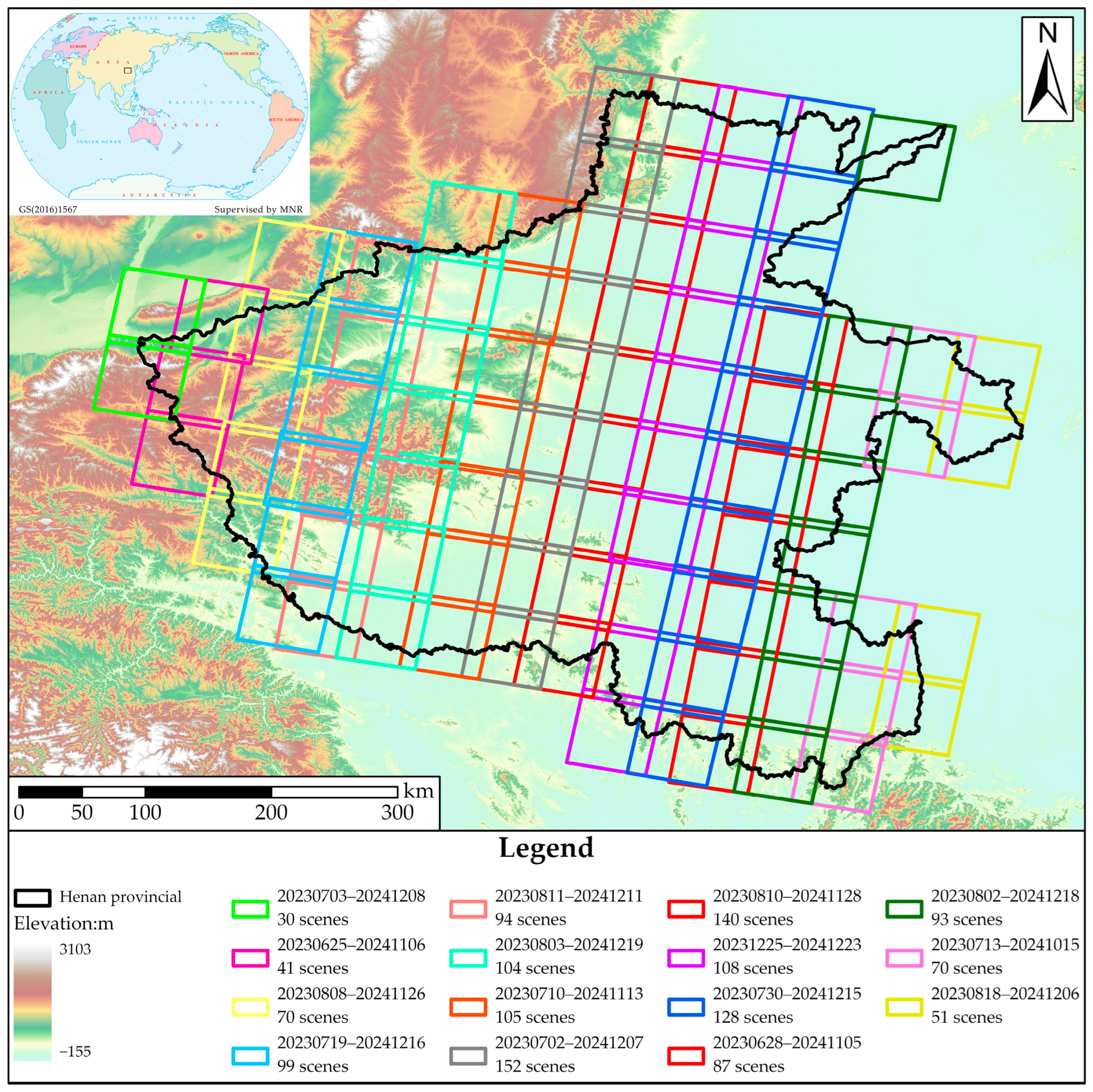
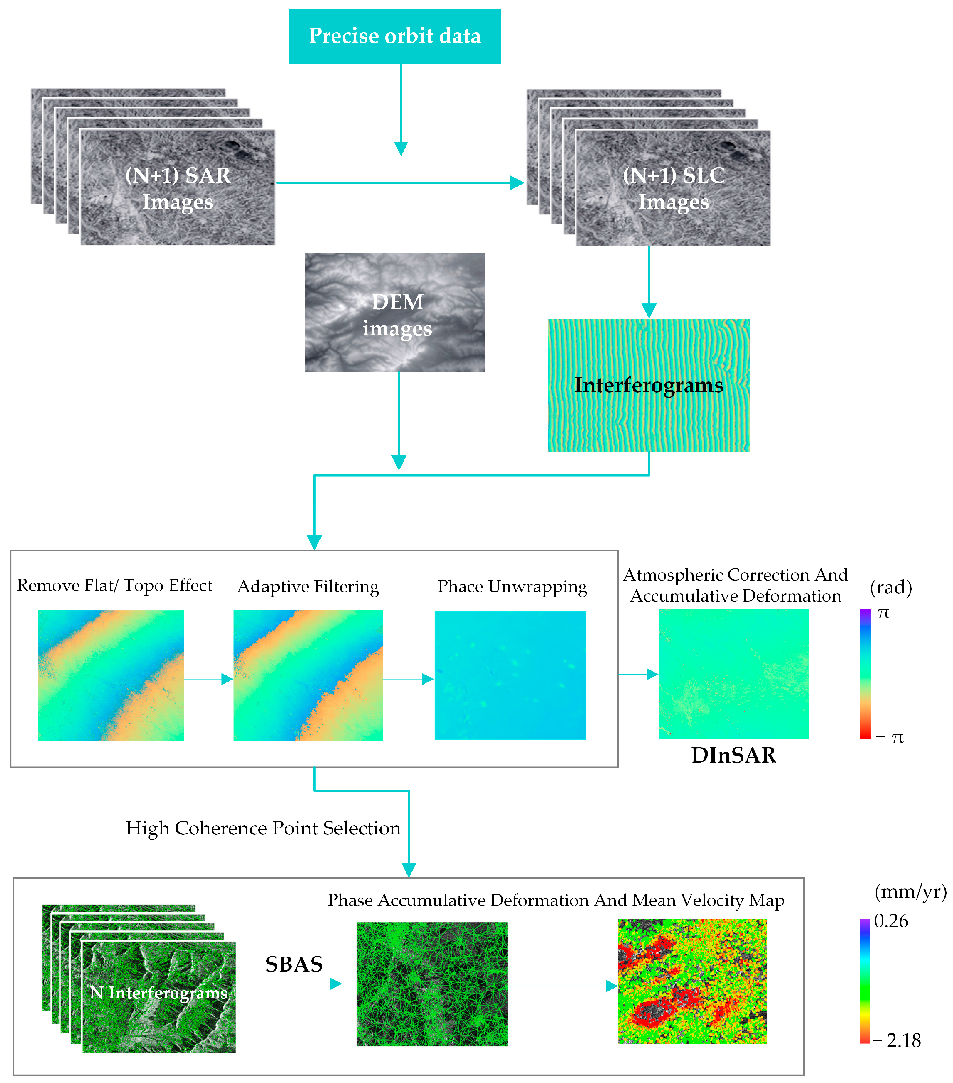

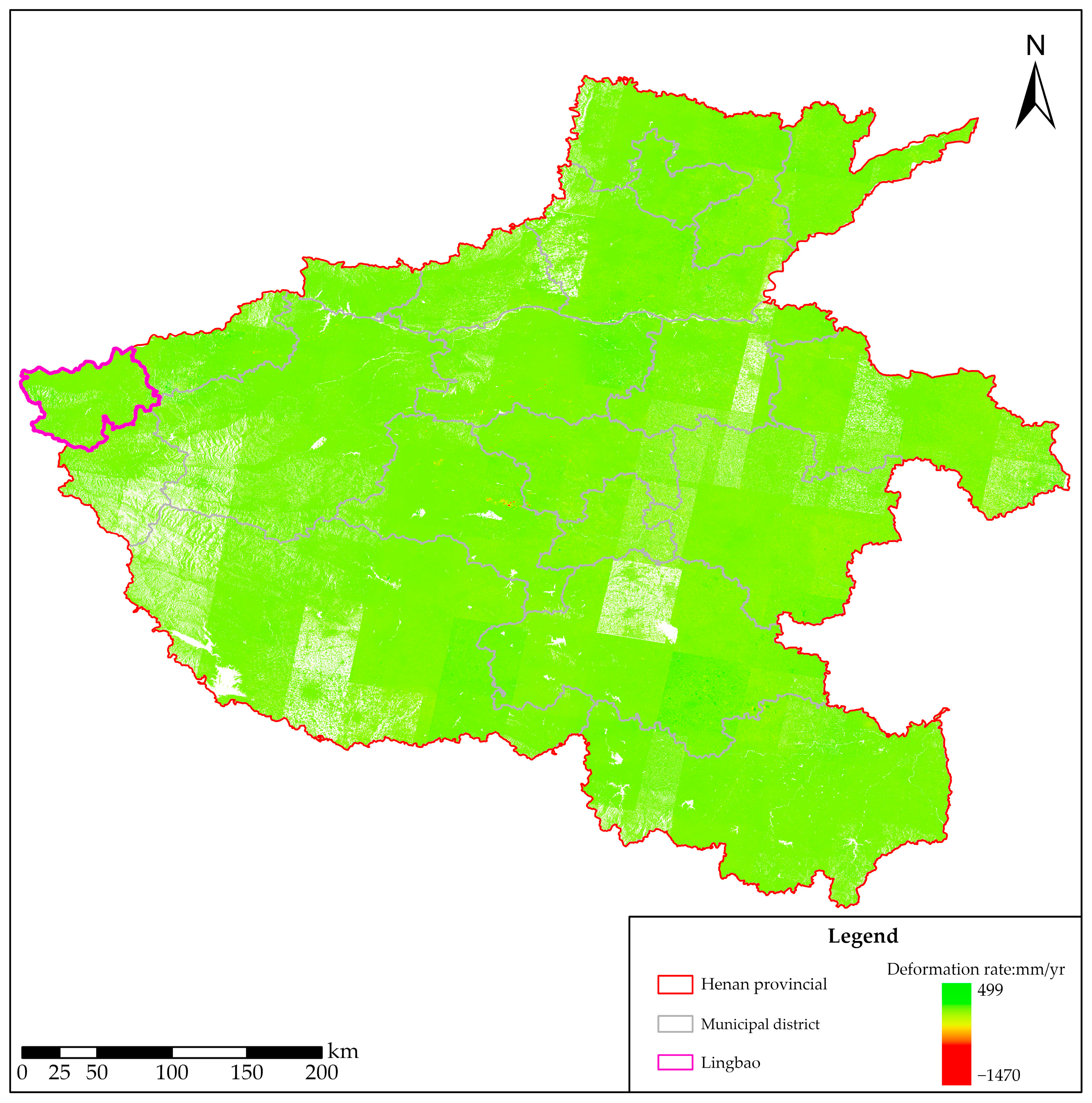
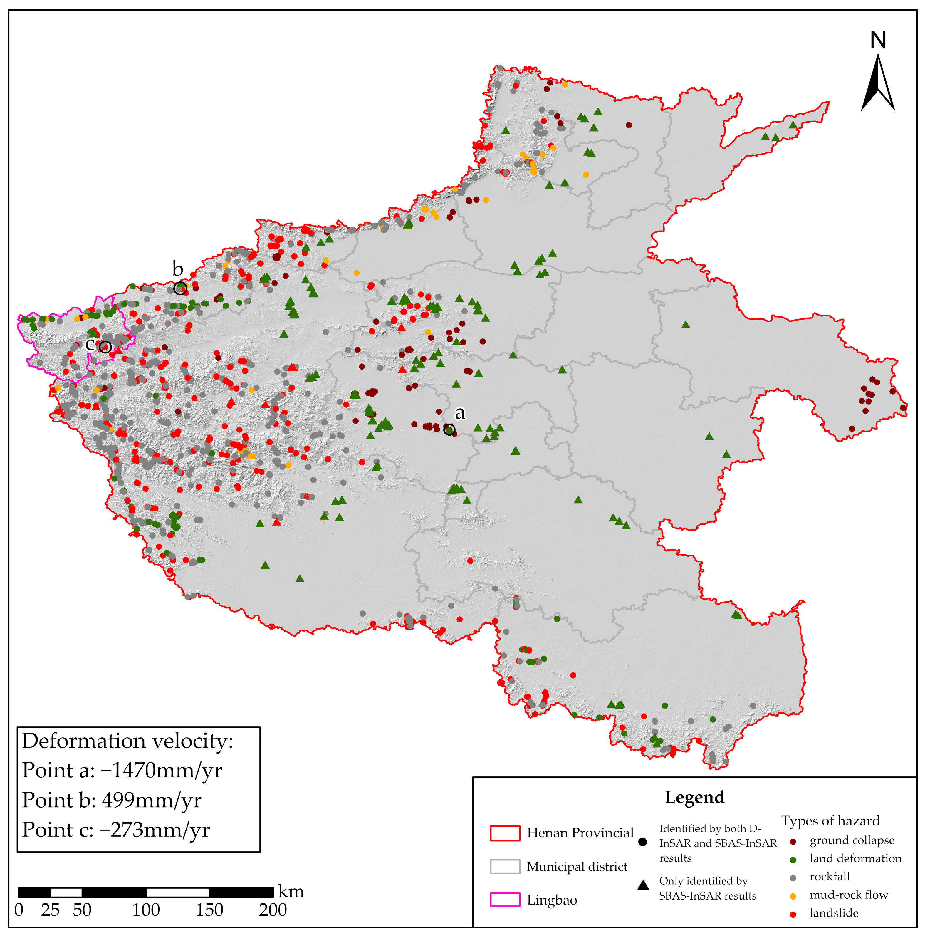


| Parameter | DInSAR | SBAS | ||
|---|---|---|---|---|
| Band | L | |||
| Wavelength (cm) | 23.8 cm | |||
| Azimuth/Range pixel spacing | 1.74 m/1.67 m | |||
| Azimuth/Ground range look | 4:2 | |||
| Polarization | HH | |||
| Acquisition time | June 2023–December 2024 | July 2023–February 2025 | ||
| Orbit direction | Ascending | Descending | Ascending | Descending |
| Number of acquisitions | 1428 | 1372 | 540 | 1176 |
Disclaimer/Publisher’s Note: The statements, opinions and data contained in all publications are solely those of the individual author(s) and contributor(s) and not of MDPI and/or the editor(s). MDPI and/or the editor(s) disclaim responsibility for any injury to people or property resulting from any ideas, methods, instructions or products referred to in the content. |
© 2025 by the authors. Licensee MDPI, Basel, Switzerland. This article is an open access article distributed under the terms and conditions of the Creative Commons Attribution (CC BY) license (https://creativecommons.org/licenses/by/4.0/).
Share and Cite
Lu, J.; Tang, X.; Li, T.; Wei, L.; Guo, L.; Zhang, X.; Zhang, X. A Study on the Identification of Geohazards in Henan Province Based on the Basic Deformation Products of LuTan-1. Remote Sens. 2025, 17, 3517. https://doi.org/10.3390/rs17213517
Lu J, Tang X, Li T, Wei L, Guo L, Zhang X, Zhang X. A Study on the Identification of Geohazards in Henan Province Based on the Basic Deformation Products of LuTan-1. Remote Sensing. 2025; 17(21):3517. https://doi.org/10.3390/rs17213517
Chicago/Turabian StyleLu, Jing, Xinming Tang, Tao Li, Lei Wei, Lingfei Guo, Xiang Zhang, and Xuefei Zhang. 2025. "A Study on the Identification of Geohazards in Henan Province Based on the Basic Deformation Products of LuTan-1" Remote Sensing 17, no. 21: 3517. https://doi.org/10.3390/rs17213517
APA StyleLu, J., Tang, X., Li, T., Wei, L., Guo, L., Zhang, X., & Zhang, X. (2025). A Study on the Identification of Geohazards in Henan Province Based on the Basic Deformation Products of LuTan-1. Remote Sensing, 17(21), 3517. https://doi.org/10.3390/rs17213517


