Highlights
What are the main findings?
- The integrated use of geomagnetic prospection, LiDAR, aerial, and satellite imagery revealed previously unknown architectural and landscape features at Neolithic sites with rondels in Eastern Croatia, including a multi-ditch system and a tear-like enclosure at Markušica, which represents an addition to standard circular or ellipsoidal rondel forms in Central Europe.
- The study identified significant differences in visibility, preservation, and site expression between Markušica and Gorjani, directly influenced by local land use, demonstrating the diagnostic value of multi-sensor datasets for interpreting archaeological sites in various environments and stages of preservation.
What are the implications of the main findings?
- The results demonstrate that integrated approach fundamentally changes the interpretation of Neolithic monumental sites, allowing detection of architectural details and site variations that remain invisible or ambiguous when using single-method surveys. This approach provides a more reliable model for understanding site formation and monumentality in transformed landscapes.
- The discovery of the tear-like ditch enclosure at Markušica suggests greater regional architectural diversity and local adaptation within the Neolithic rondel tradition of Central and Southeastern Europe, motivating the future research of architectural tradition in this part of the Neolithic world.
Abstract
This paper represents the results of ten years of monitoring using satellite imagery and aerial reconnaissance, followed by in-depth analysis utilizing LiDAR data and geomagnetic prospection techniques of the first two Neolithic rondels detected in Croatia—Markušica Brošov salaš and Gorjani Topole. Through the exclusive use of satellite and aerial image analysis, we were able to accurately determine the general size, shape, and number of ditches present at the sites under investigation. The wealth of information obtained from these images was sufficient for us to confidently interpret these formations as Neolithic rondels—meeting all the criteria commonly used. The addition of LiDAR data and geomagnetic prospection further enhanced our understanding by revealing a range of additional features and peculiarities across both sites, including within all identified ditch systems. These advanced methods allowed us to uncover details that would otherwise remain invisible through surface observation alone. Our research demonstrates the remarkable power of publicly available satellite imagery as a primary tool for archeological site detection and preliminary interpretation. The results from Markušica and Gorjani emphasize the scientific necessity of combining complementary remote sensing and geophysical techniques to overcome individual methodological limitations, providing robust documentation and interpretation of prehistoric enclosures in highly transformed landscapes. This research contributes novel insights into Neolithic social landscapes, monumentality, and land use strategies in Croatia while offering a methodological model for archeological prospection applicable across Central and Southeastern Europe.
1. Introduction
Neolithic rondel enclosures, characterized by circular or ellipsoidal arrangements of ditches and palisades, are among the most distinct monumental features of the European Neolithic landscape. Dating primarily to the early–mid-5th millennium BC, these structures have been identified across Central Europe, with notable concentrations in the Carpathian Basin, the Czech Republic, Poland, and now in Croatia as well [1,2,3,4]. Rondels are widely interpreted as multifunctional sites, potentially serving ritualistic, social, and territorial roles tied to emergent complex prehistoric communities [5,6,7]. It suggested that they have a certain prototype that reflects shared manifestation of activities on a larger scale [8].
Recent archeological research underscores the importance of these enclosures as markers of social negotiation and spatial organization in Neolithic societies. Large multi-ditch rondels with diameters ranging from 30 to over 240 m often cluster regionally, suggesting competitive and cooperative symbolic landscapes reflecting contemporary social hierarchies and territoriality [1]. Understanding the morphology, distribution, and changing functions of rondels is crucial for reconstructing prehistoric land use, social networks, and the transition toward more stratified settlement patterns in prehistoric Europe.
Methodologically, the integration of advanced non-invasive techniques such as geomagnetic prospection, LiDAR scanning, and aerial and satellite imagery has dramatically enhanced the detection and interpretation of these subtle archeological features, especially in heavily altered landscapes [9,10,11]. Geomagnetic surveys, in particular, allow for the precise mapping of ditch layouts, palisades, and internal features that are otherwise invisible due to erosion, plowing, or modern land use. The combination of remote sensing with historical cartographic data further contextualizes these sites within long timelines of landscape transformation and anthropogenic impacts.
New studies in neighboring areas of the Carpathian Basin have revealed the effectiveness of geophysical investigations and led to discoveries such as the site of Borđoš, with both a long-occupied tell and an extensive flat settlement whose plan diverges from traditional layouts [12]. Research has further identified some of the largest Late Neolithic villages in Europe, bringing forward the concept of the “Tell-Centered Settlement Complex,” where central tells are surrounded by expansive villages covering up to 90 hectares. The application of magnetometry and other geophysical methods has accelerated the survey of vast areas and enabled the discovery of large, complex settlement structures over the last decade [12,13]. This aligns with recent extensive fieldwork, which demonstrated that a magnetometric survey is now the primary tool for remote archeological feature identification and for understanding the organization of Neolithic settlements, yet other minimally invasive methods continue to provide valuable complementary insights.
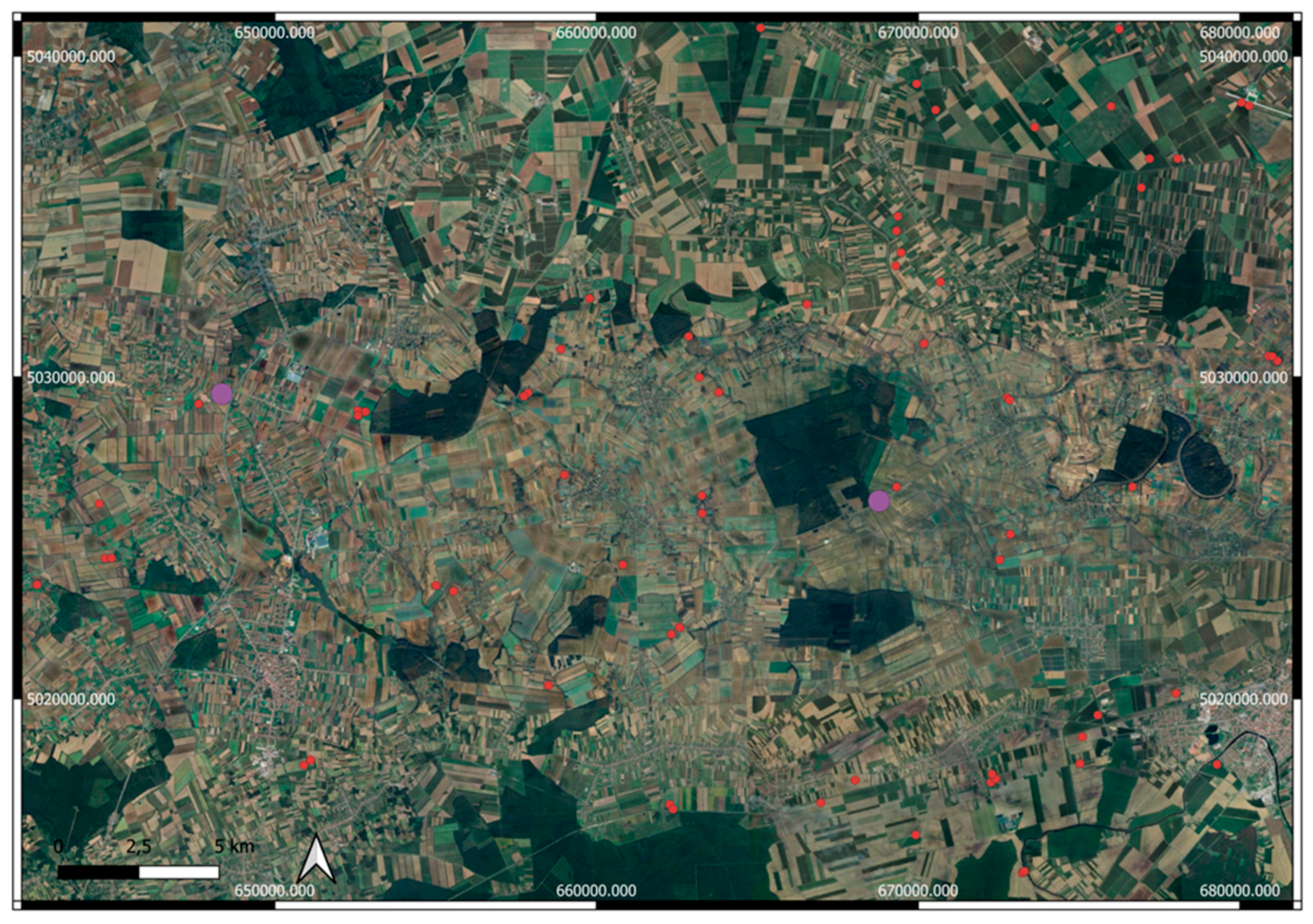
In Croatia, key sites such as Markušica and Gorjani in Eastern Slavonia are central to understanding regional variability (Figure 1). Located near the known area of rondel distribution, these locations reveal complex ditch morphologies and distinctive preservation patterns. Recent geomagnetic surveys have uncovered multiple ditch systems with clear differences in landscape integration, providing crucial data for evaluating local characteristics within the wider context of Central European Neolithic monumental practices [14,15]. The present study builds upon these advances, aiming to synthesize novel geospatial and geophysical methods, integrate large-scale prospection with focused excavation, and re-evaluate the significance and diversity of Neolithic enclosures in Southeastern Europe [12,13].
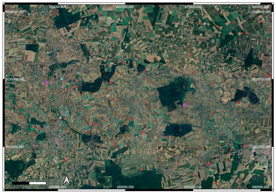
Figure 1.
Geographical position of the sites on a map along the known Neolithic enclosures in Eastern Croatia. Sites Gorjani and Markušica are marked with violet dots.
Traditional analyses based on satellite/aerial imagery or geomagnetic prospection alone offer only partial visibility of rondel structures and features. For example, crop marks and soil marks seen in orthophotos do not always align with magnetogram anomalies, and LIDAR may fail to identify subtle micro-topographic features where previous geomagnetic or aerial evidence exists (for example, western rondel in Markušica in this paper). Thus, the full architecture, chronology, and transformation processes of rondels often remain obscured or misinterpreted when relying on individual methods.
This study aims to contribute to the understanding of Neolithic rondels in Croatia by examining the Markušica and Gorjani sites through combined geomagnetic prospection, multi-spectral remote sensing (including LIDAR and satellite imagery), and historic cartographic analysis. By situating these sites within the broader Central European context of rondel research, this work contributes to ongoing scholarly discussions about the social significance, architectural variability, and chronological frameworks of these prehistoric enclosures. Moreover, this research highlights the critical role of integrated methodological approaches in exploring and interpreting archeological features that are otherwise obscured in highly modified landscapes. The attribution of the sites to Neolithic period was confirmed by excavation radiocarbon dating (Gorjani Topole) and multiple field surveys (Markušica).
The integration of geomagnetic, LiDAR, and multi-temporal aerial/satellite imagery enables nuanced mapping and cross-verification of ditches, entrances, palisades, and settlement features. It dramatically alters archeological interpretation features invisible in one dataset (e.g., a tear-like ditch shape at Markušica seen only in magnetometry) which become detectable and reliably attributable when datasets are combined. However, the broader implications of these changes for site formation, visibility, and the reliability of interpretations have not been systematically assessed.
Our objective was to systematically assess how multi-sensor integration (geomagnetic, LiDAR, satellite/aerial imagery, historical cartography) improves the scale and reliability of Neolithic rondel identification and interpretation in transformed landscapes, and our main research hypothesis was that the combination of multiple datasets enables the detection of architectural features (e.g., ditches, entrances, palisades, houses) that remain invisible or misinterpreted in single-method surveys.
2. Materials and Methods
For this research, we constructed a multi-scalar and diachronic methodological framework, combining modern remote sensing, geophysical prospection, aerial survey, and historical cartographic sources. By integrating datasets spanning from the late 18th and 19th centuries (Habsburg military and cadastral cartography), through systematic satellite and aerial monitoring (2006–2024), to high-resolution geomagnetic survey and LIDAR analysis, the study provides a comprehensive view of site formation, transformation, and preservation. Special attention was given to the temporal dimension of data acquisition, not only in terms of multi-year/century coverage but also with respect to the seasonal timing of imagery, as vegetation and soil conditions significantly affect the visibility of archeological features. The following subsections describe the employed methods in detail.
2.1. Satellite and Orthophoto Imagery
High-resolution satellite imagery was obtained from Google Earth Pro [16], covering the period between 2006 and 2024. This diachronic dataset allowed for the observation of long-term landscape and site transformations. Particular attention was paid to the seasonality of image acquisition, since vegetation cover and soil moisture variations at different times of year could enhance or obscure archeological traces.
Additionally, orthophotos provided by the Croatian State Geodetic Administration [17] were used for detailed spatial analysis. Here, too, seasonal aspects of imagery were considered when selecting datasets most suitable for archeological interpretation (Table 1).

Table 1.
Markušica 1 and 2, number of ditches visible on selected orthophoto, satellite and drone images.
2.2. Unmanned Aerial Systems (Drone Surveying)
Low-altitude aerial footage was acquired using unmanned aerial vehicles (UAVs) operated by the authors. Surveys were carefully timed to coincide with periods when vegetation height, surface moisture, and light conditions favored maximum visibility of archeological features. These datasets provided high-resolution documentation for micro-topographical observation and site analysis. Most of the drone surveys were conducted during early June since our experience showed that this is the period of best visibility of the sites, but so that the all-year-round monitoring ensured best results [18,19,20].
2.3. Aerial Photography (Manned Aircraft)
Complementary aerial images were collected from manned flights conducted by the authors. These flights were scheduled with reference to seasonal conditions in order to optimize the detection of crop marks and soil marks. The resulting imagery contributed to a landscape-scale interpretation of archeological features in their environmental context. Aerial surveys were conducted all year to ensure documenting visibility in different environmental and agricultural circumstances [18,19,20].
2.4. Geomagnetic Prospection
Geomagnetic prospection is among the most used methods used to detect subsurface archeological Neolithic anomalies and to map structural remains invisible from the surface [18,19,20].
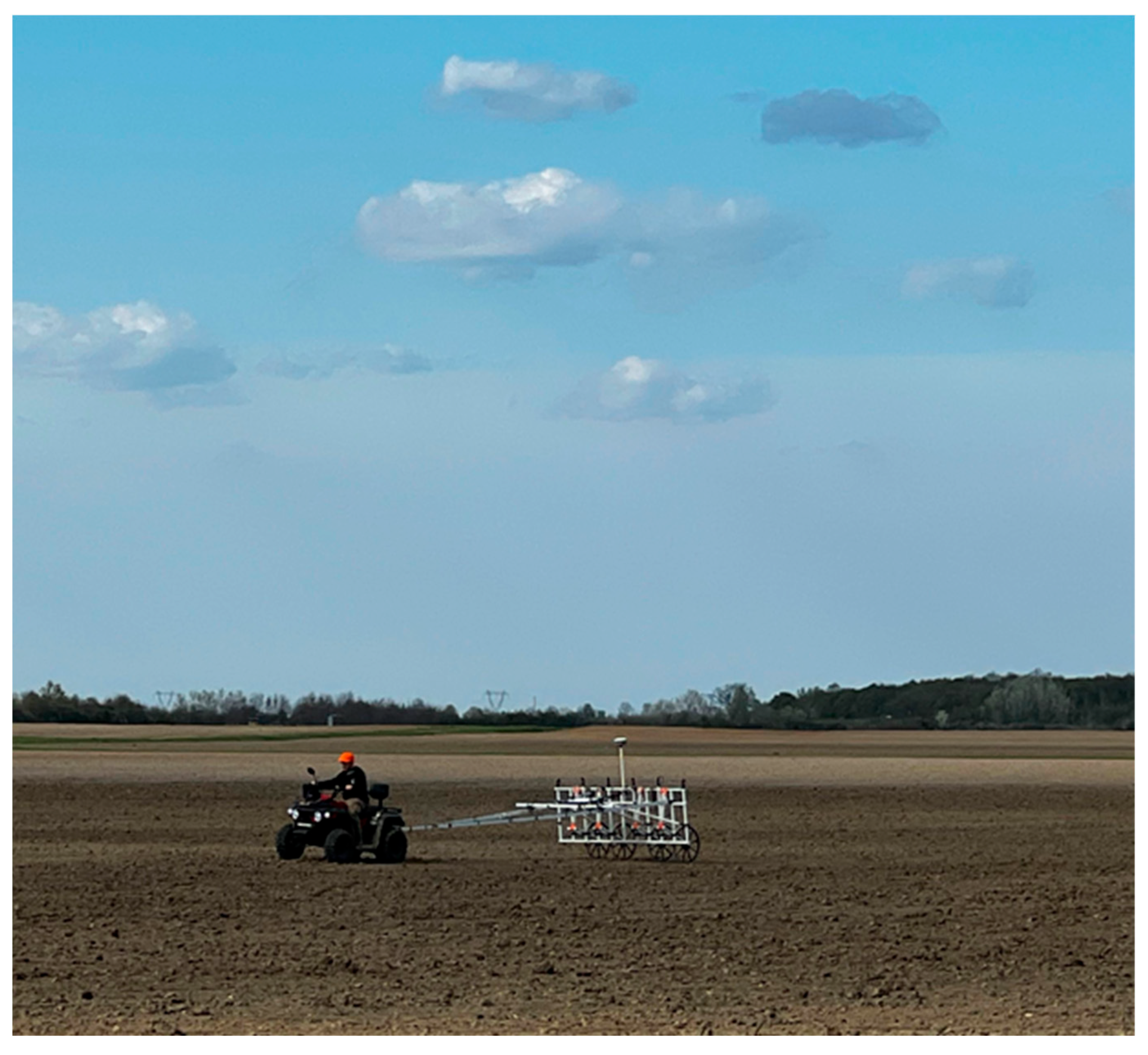
Geomagnetic prospection of the Gorjani sitewas carried out by company prospection [21,22,23,24,25], while geomagnetic prospection of site Markušica were performed by the authors in April 2025. For Markušica, we used the Sensys Magneto MX V4 system with six sensors, fluxgate Sensys gradiometer FGM650/3: ±8 μT, at a distance of 50 cm towed by quad vehicle (Figure 2). The resolution is <0.2 nT. Data was collected by MonMX 5.01-14 software and navigation by differential Stonex GNSS system.
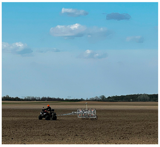
Figure 2.
Geomagnetic prospection of Markušica site.
For data processing, we used MAGNETO software. The processed data were exported to QGIS and Global Mapper for map production and overlaid with other types of data.
2.5. LiDAR Data Analysis
Airborne LiDAR data were obtained from the Croatian State Geodetic Administration [24], with a point density of 4 points/m2. The datasets were processed and visualized using the Relief Visualization Toolbox [26,27,28,29] implemented as a QGIS plugin (QGIS Development Team 2022), as well as Global Mapper (Blue Marble Geographics, 2023). LiDAR-derived visualizations facilitated the recognition of micro-topographic features and the identification of anthropogenic landscape modifications linked to archeological remains [30,31].
2.6. Historical Cartographic Sources
To contextualize present-day landscape and site conditions, historical cartographic sources were integrated into the study and accessed via the Arcanum Map Archive [32]. The following collections were used:
- Europe in the 18th Century (First Military Survey);
- Second Military Survey of the Habsburg Empire—Croatia (1865–1869);
- Europe in the 19th Century (with the Third Military Survey);
- Habsburg Empire—Cadastral Maps (19th Century).
These maps were employed to reconstruct the historical use of agricultural fields and land parcels within the study areas. By comparing historical land use patterns with present-day conditions, we were able to evaluate how past agricultural practices and land management have influenced the current state of preservation of archeological sites.
3. Results
Both sites with rondels were discovered using remote sensing and were previously unknown as archeological sites [18,19,33]. Detailed analysis of publicly available data enabled coherent interpretation of site structure and layout. Geomagnetic prospection confirmed the interpretation and added new elements, while LiDAR data analysis showed new insights into each site’s microtopography and formation processes.
Criteria used for the interpretation of the sites as rondels were used from the available literature, mostly synthesized by [1]. Rondels typically reveal no more than circular ditches and palisade trenches, with diameters ranging between 30 and 240 m, enclosing a largely empty interior space that is accessed via two to six entrances that are closely linked with domestic activity and are always found within areas of settlement or with nearby residential structures [1].
Site Markušica can be categorized as a multi-rondel site since there are two rondels with other types of ditches and features between them.
This stage of interpretation relies on the integration of data from various sources: field surveys, aerial and satellite remote sensing, geomagnetic prospection, and mapping. Ditch positions have been highlighted in the imagery, and the number of visible ditches are recorded in Table 2 for each image or dataset, enabling a systematic comparison and supporting the identification and mapping of settlement structures.

Table 2.
Comparation of three rondels by their characteristics.
Three rondels show mutual similar characteristics but also significant differences in their shape, elements, position and surroundings, as illustrated in Table 2.
3.1. Site Markušica
At the archeological site of Markušica, there are large ellipsoidal enclosures with two ditches. Within the central enclosure lies a smaller, empty rondel, and an additional small rondel can be found to the west of the main enclosures. Numerous archeological features are located inside the larger ellipsoidal ditches, as well as in the area between the western small rondel and the main enclosure, suggesting complex settlement activity within and around the ditches. We marked the western rondel Markušica 1 and the eastern complex Markušica 2.
- Markušica 1
The outermost ditch at Markušica 1 measures approximately 154 by 136 m. The associated small ditch lacks internal features and is characterized by ditches positioned very close to one another.
- Markušica 2
The larger enclosure at Markušica 2 has dimensions of 445 by 411 m. Within this area, the larger inner rondel measures about 165 by 165 m, and the smaller inner ditch is approximately 70 by 75 m. Settlement features, likely related to domestic activity, are found between the large ditches and the western rondel, indicating the site’s significance as a habitation area during the Neolithic period.
3.1.1. Historical Sources
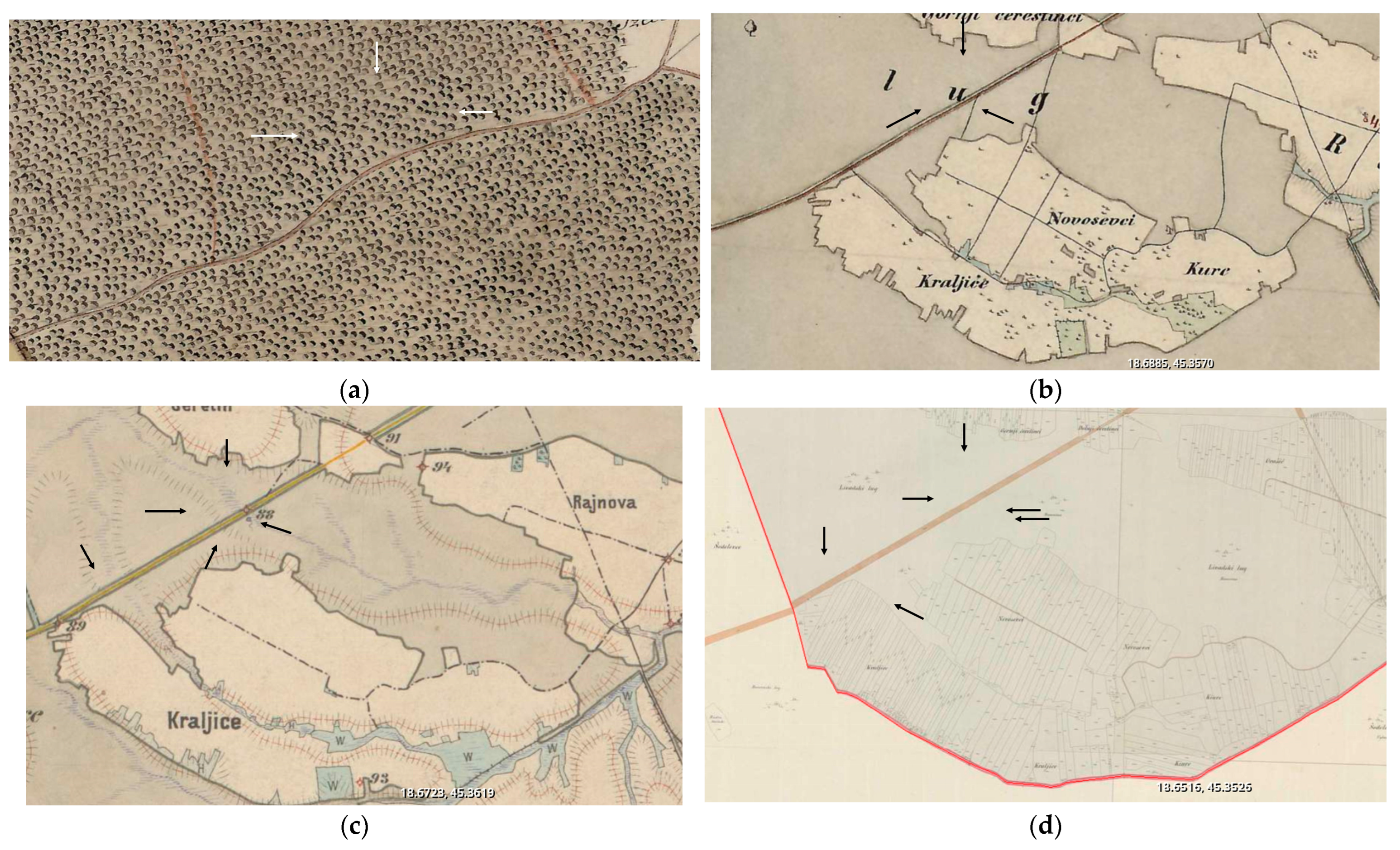
The current state of preservation and the visibility of the rondels are the results of long-term changes in the environment since the sites’ abandonment. The earlier changes are not documented, and there are no archeological finds from later prehistoric or historic periods, but analysis of historical maps from the 18th and 19th century show the interventions that are still visible today. Before the first military survey in the 18th century (because it is visible on that map, going thought the forest), a dirt road was built, which is still in use, that cuts the site in two, leaving two thirds on its northern side and one third on its southern side. That was probably the root of the changes in preservation (Figure 3a). On maps from the 19th century (Figure 3b,c), the area of the southern part of rondel 1 is marked as a field, while other areas are still under woods, and on cadastral maps from the 19th century that area is divide into many small parcels (Figure 3d). These different land biographies, at least in the 18th and 19th century, probably caused the low visibility of the southern part of the rondel Markušica 1 since it was under constant agricultural activity. Parts that were under woods were better preserved.
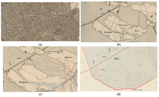
Figure 3.
Position of the Markušica site on historical maps: (a) First Military Survey (1783–1784) https://maps.arcanum.com/en/map/europe-18century-firstsurvey/?bbox=2073541.2080043554%2C5675860.799097528%2C2082603.7731704167%2C5679200.141770736&map-list=1&layers=here-aerial%2C163%2C165; (b) Second Military Survey (1865–1869) https://maps.arcanum.com/en/map/europe-19century-secondsurvey/?bbox=2073947.2797171206%2C5676085.332868118%2C2083048.0633973244%2C5679501.1125696115&map-list=1&layers=158%2C164; (c) Third Military Survey (1869–1887 https://maps.arcanum.com/en/map/thirdsurvey25000/?bbox=2073947.2797171206%2C5676085.332868118%2C2083048.0633973244%2C5679501.1125696115&map-list=1&layers=129; (d) Habsburg Empire—19th century cadastral map, source: https://maps.arcanum.com/en/map/cadastral/?bbox=2073947.2797171206%2C5676085.332868118%2C2083048.0633973244%2C5679501.1125696115&map-list=1&layers=3%2C4 (all accessed on 2 July 2025).
3.1.2. Orthophoto Data
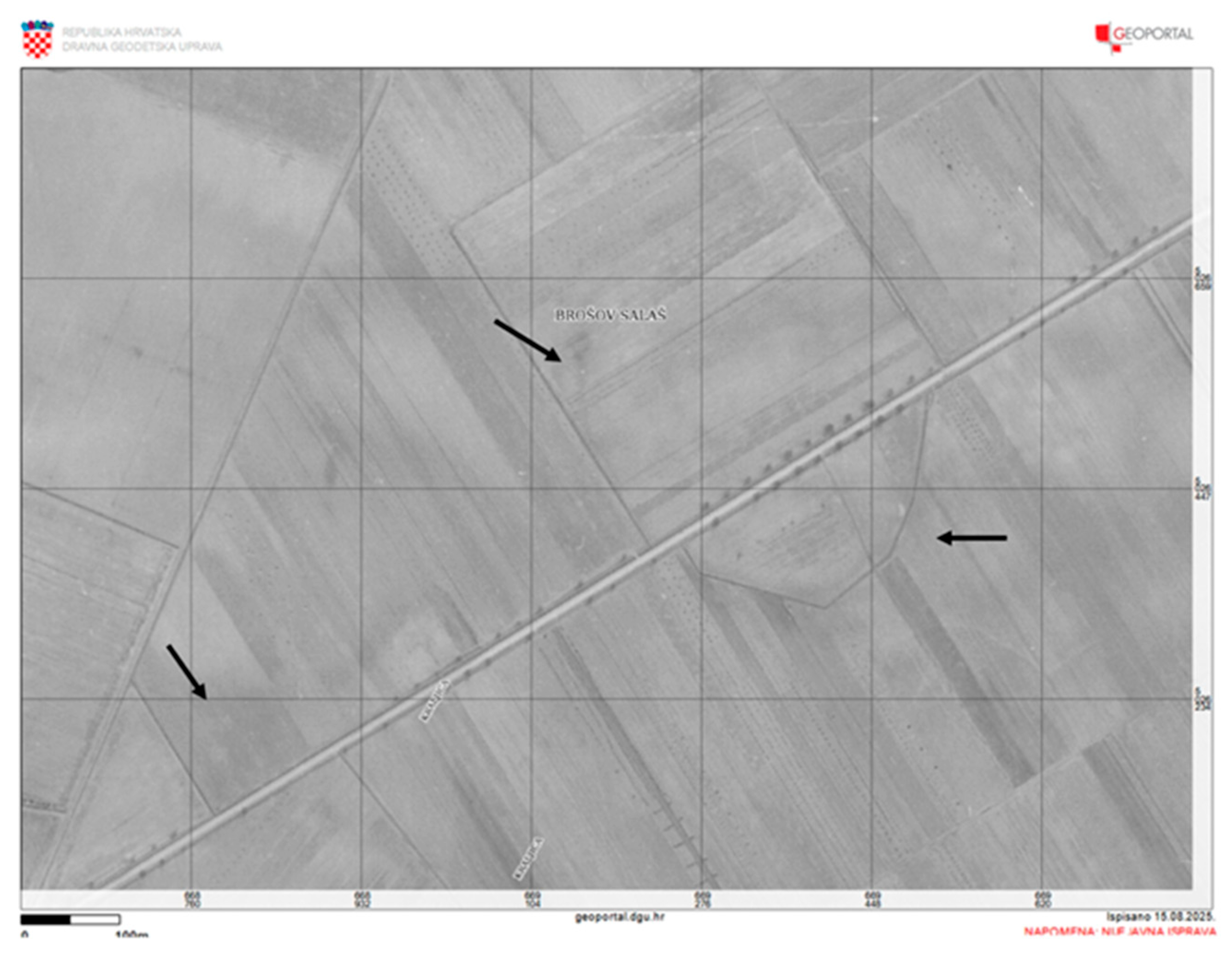
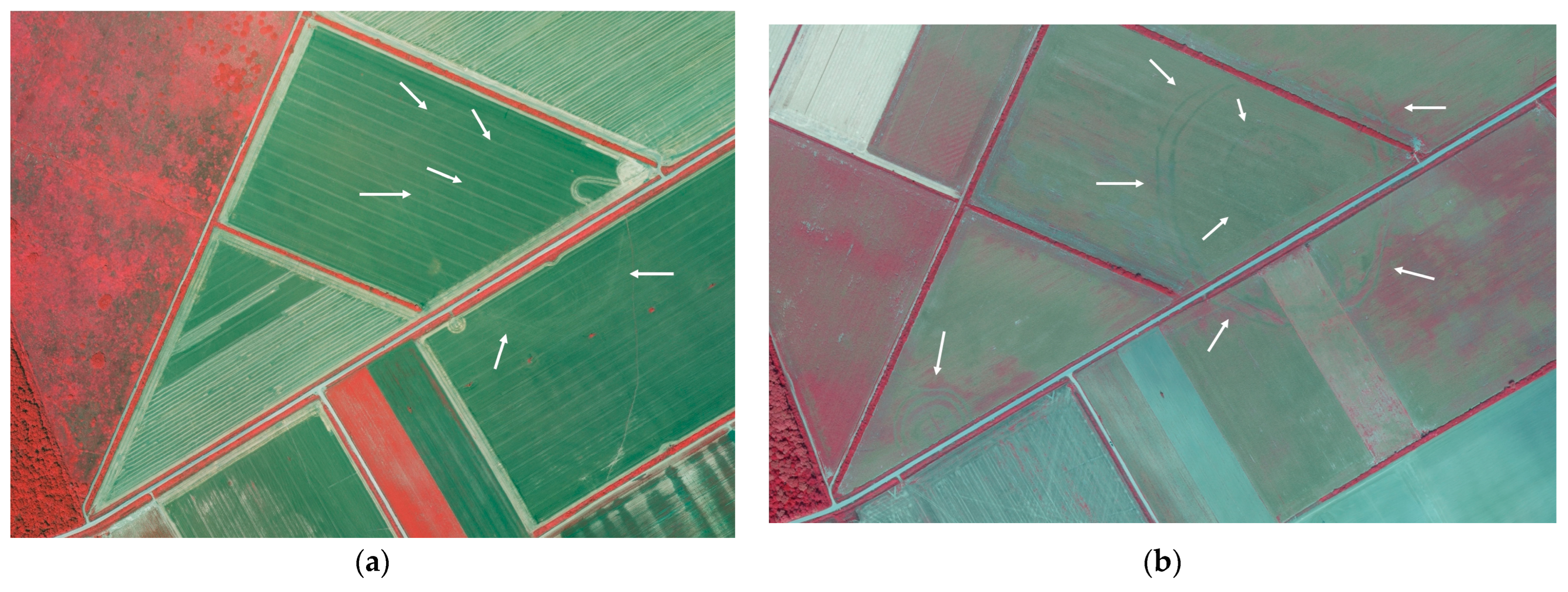
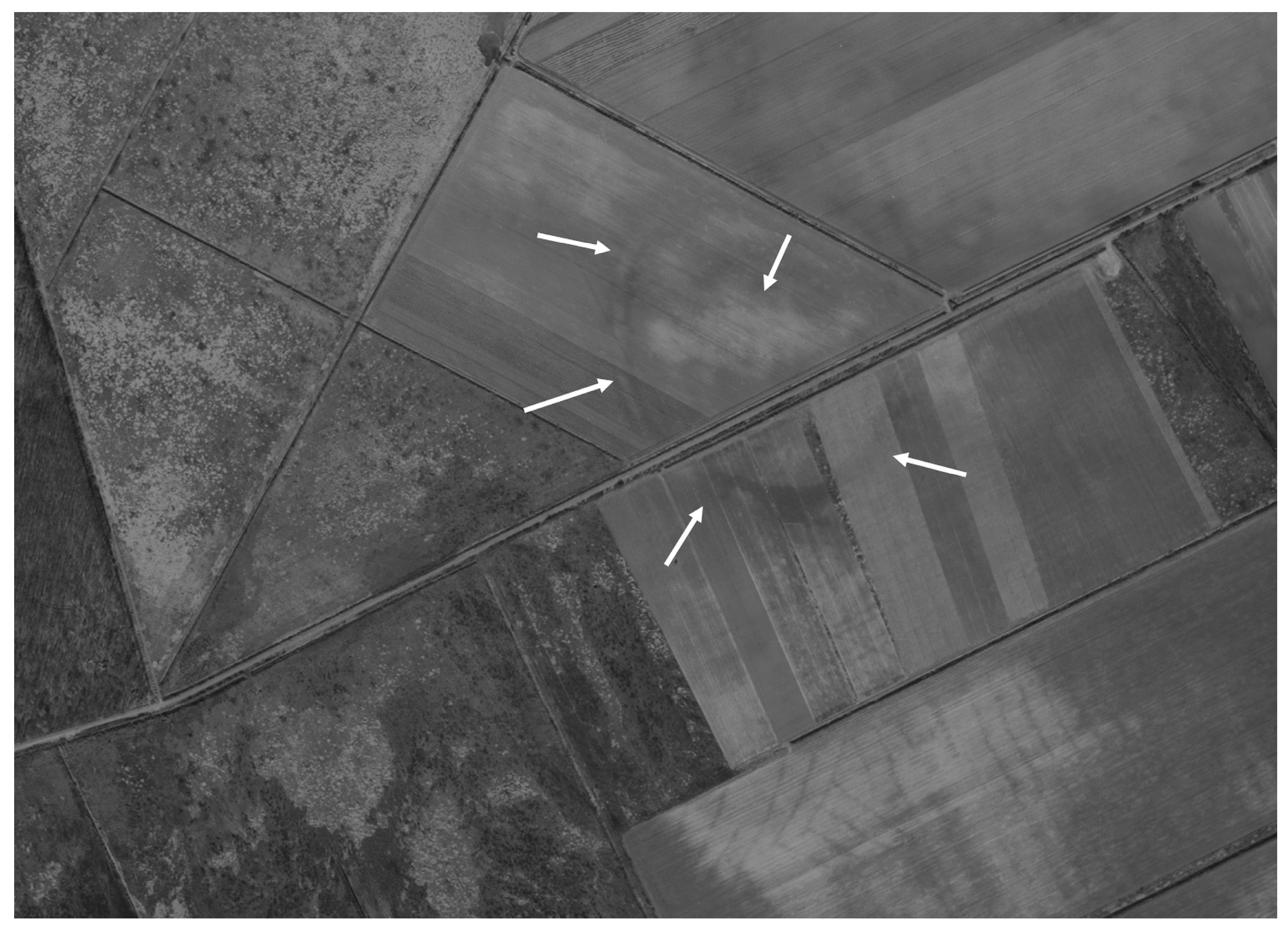
The earliest publicly available orthophoto image originates from the period before 1968. Valuable resources are digitalized black and white images originating from the Military Geographical Institute, Belgrade, and have been available since 2015, first on ISPU Geoportal (https://ispu.mgipu.hr/) and later on Geoportal DGU (https://geoportal.dgu.hr/). In this image, Markušica 1 is not visible; only one segment of the big ditch of Markušica 2 is visible, as well as the rondel outer ditch (Figure 4). However, the most interesting feature on this image is the southern part of the big ditch that is still in use as a drainage channel. This is not uncommon since some of the Neolithic ditches are even in use today (for example, Preslatinci, Tordinci, Josipovac Vinogradine) [19], which testifies to the long-term impact on the environment. CSGA high-resolution multi-channel RGBI orthophoto images were recorded with UltraCam Lvl03 from altitude of app. 4700 m and processed in UltraMap Image Export 22.3.1709.1801. The image from 2011 is poor for archeological purpose (Figure 5a) while the image from 2017 is very good, both showing archeological features as crop marks (Figure 5b).
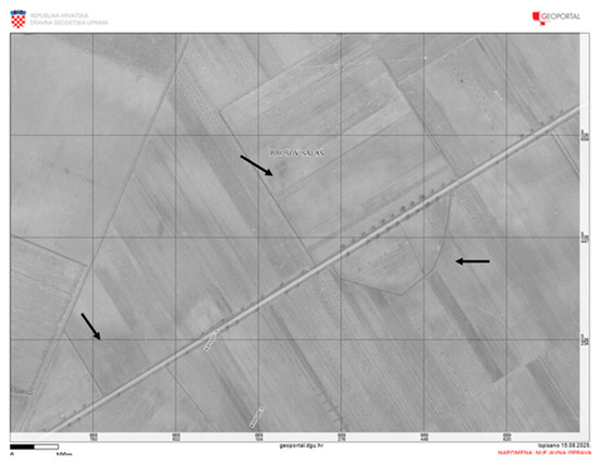
Figure 4.
Markušica site on Geportal 1968. Source: Geoportal.dgu.hr. (accessed on 2 July 2025).
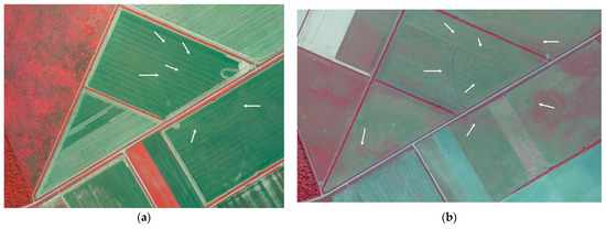
Figure 5.
Markušica site on CSGA high-resolution multi-channel RGBI orthophoto image: (a) image from 2011 with poor visibility ellipsoid on rondel, and (b) image from 2017 with very good visibility ellipsoid on rondel and western rondel with three ditches.
The basis of this research was a comparative image study of nine cyclic photogrammetric surveys made by CSGA in the period from 1997 to 2024 (Figure 6). The first two surveys were made in panchromatic technique, the third in color technique on films frames 23 × 23 cm from an altitude of ca. 3000 m; these images were finally digitalized. The other surveys were made by digital camera in high-resolution multi-channel RGBI mode. Here, small but significant part of the available images are presented.
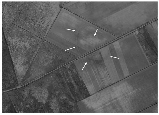
Figure 6.
Markušica 2 site on CSGA vertical image from 1997, visible as soil marks.
3.1.3. Drone
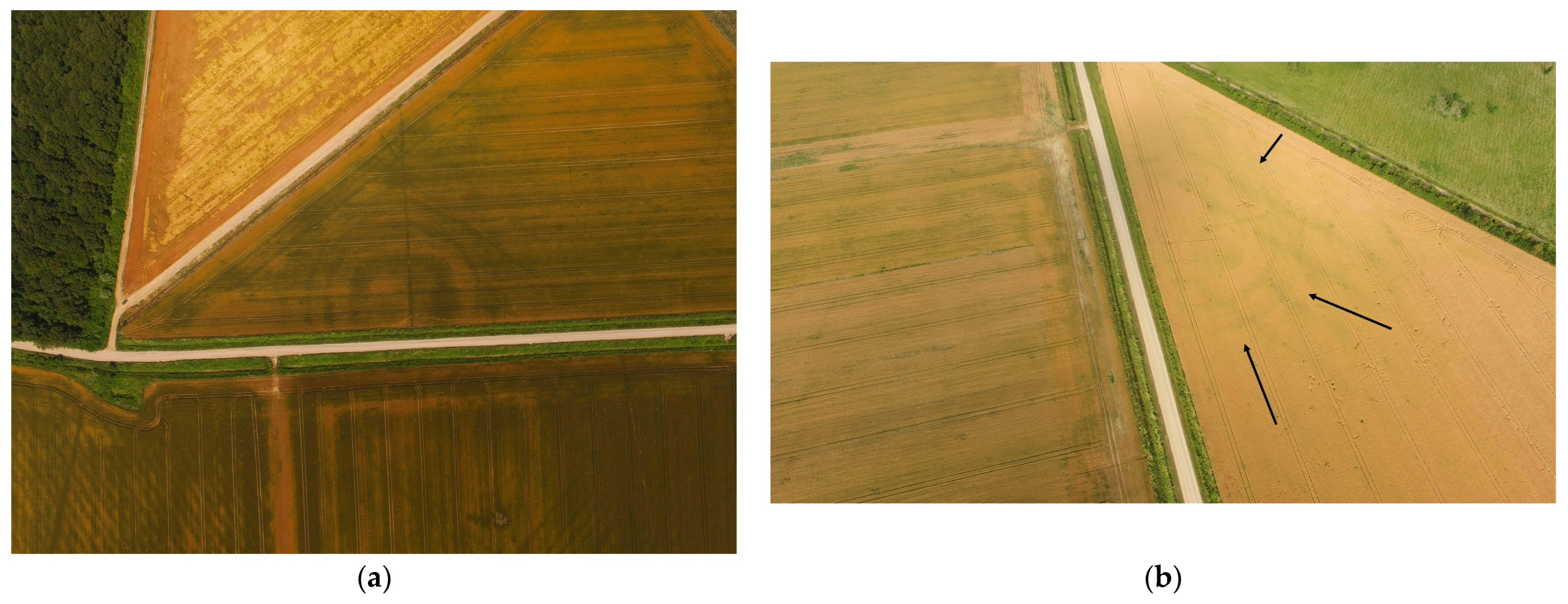
Drone surveys were conducted by the authors using DJI Phantom 3 and DJI Mavic drones. As marked on the figures, the ditches of the small rondel and the big enclosure are clearly visible (Figure 7, Figure 8 and Figure 9). With drones, June is good for crop mark tracing of the enclosures on the Markušica site (Figure 8a,b) while late autumn is good for recording soil marks (Figure 7 and Figure 9).

Figure 7.
Markušica 1 and 2 sites on oblique drone images. (a) View from south altitude 298m, (b) view from west altitude 296 m, both visible as soil marks. DJI Phantom 3 advanced, 23 September 2015.
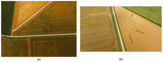
Figure 8.
Markušica 1 on oblique images. (a) Drone, DJI Mavic, 16 June 2019, altitude 268 m, visible as crop marks; (b) aerial photography, 10 June 2015, visible as crop marks, airplane flight at 200 m.

Figure 9.
Markušica 1 and 2 sites on oblique drone images. (a) View from the north, (b) view from the south, both mostly visible as soil marks and small parts in the south as crop marks. Altitude of drone: 267 m. DJI Phantom 3, 23 October 2015.
3.1.4. Google Earth
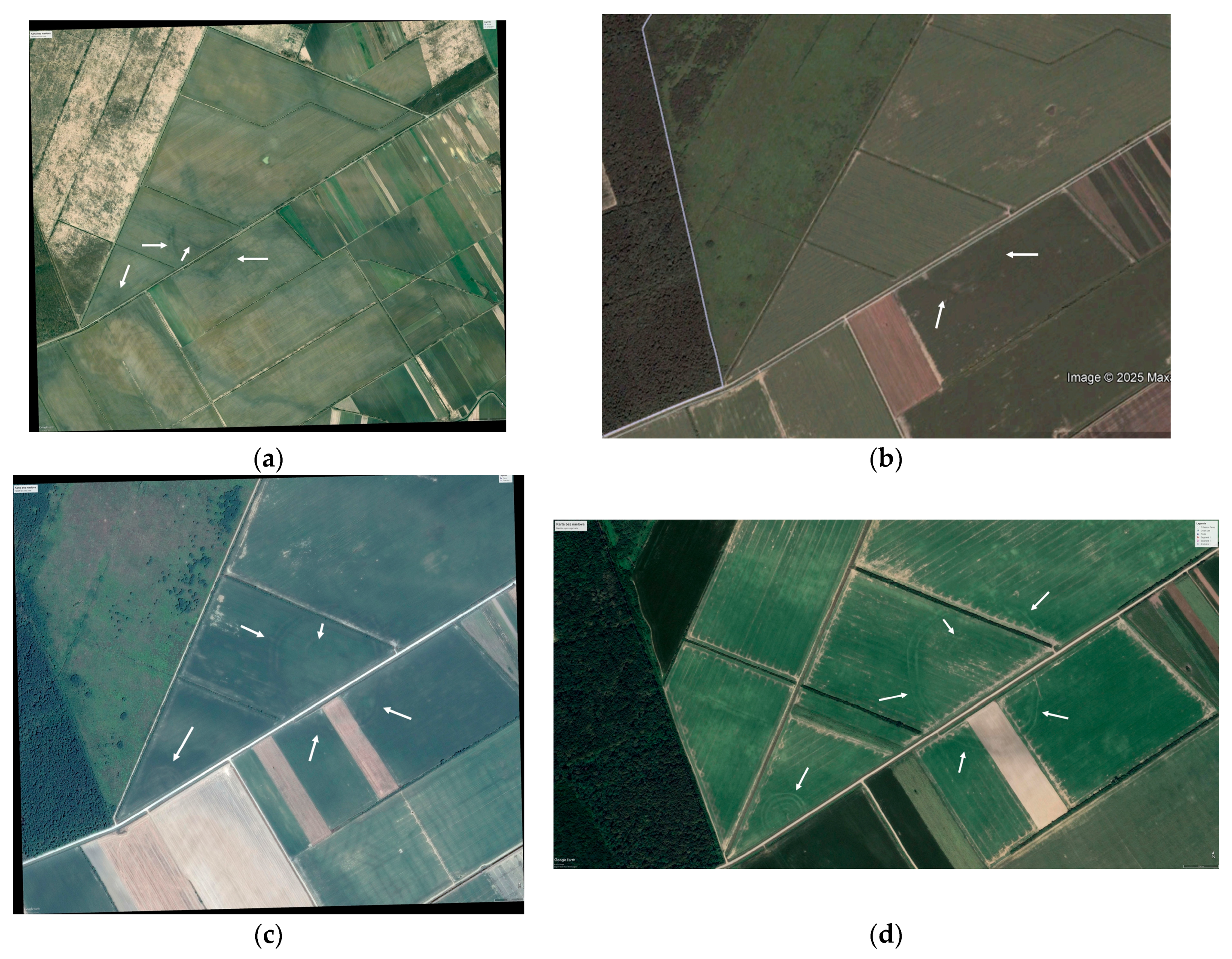
On Google Earth, there are high-resolution images from March 2006, July 2010, August 2013, May 2015, March 2017, June 2017, July 2017, February 2019, March 2019, March 2020, July 2020, August 2020, January 2021, and October 2022 (two images). On all of them, at least a segment of the rondels is visible, while on most of them majority of the ditches are present. Here, we present a selection of images. The earliest Google Earth image originates from March 2006 (Figure 10a), which is the image where the site is first spotted. There, the southern part of the rondel Markušica 1 is not visible, but the segment of the northern part of the ditch is visible, which is the only occurrence beside the unclear shape in (Figure 6). The best visibility is from August 2020 (Figure 10d), while in the image from July 2010 only one segment of the southern part of Markušica 2 is visible (Figure 10b), which is the worst visibility of all. August is good for crop mark traces of the enclosures on the Markušica site (Figure 10c,d).
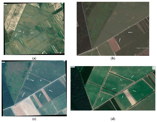
Figure 10.
Markušica 1 and 2 sites on Google Earth satellite images (a) from 24 March 2006, visible as soil marks, (b) from 13 July 2010, (c) from 12 August 2013, and (d) from 1 August 2020, all visible as crop marks (accessed on 12 June 2025).
3.1.5. LiDAR Data
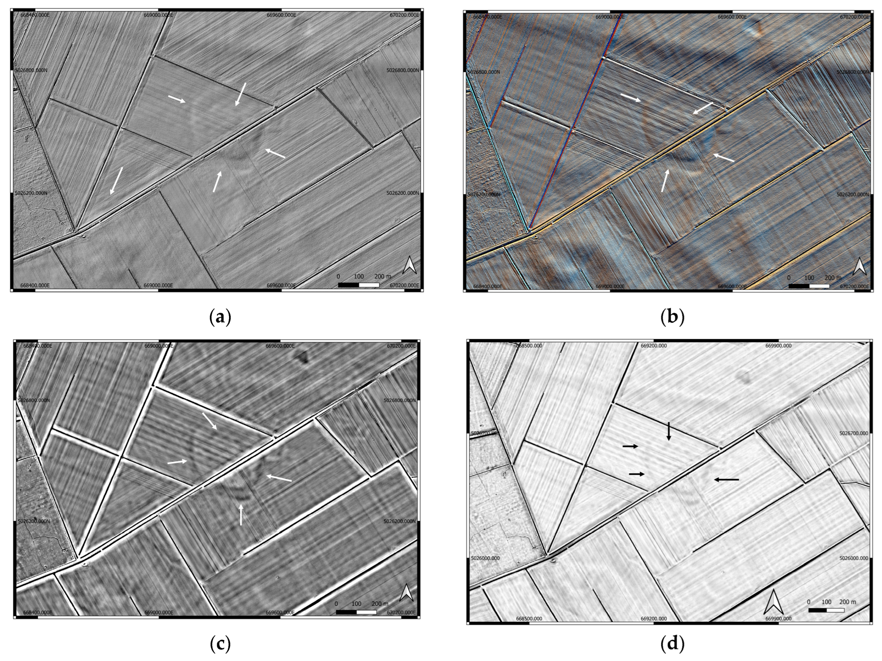
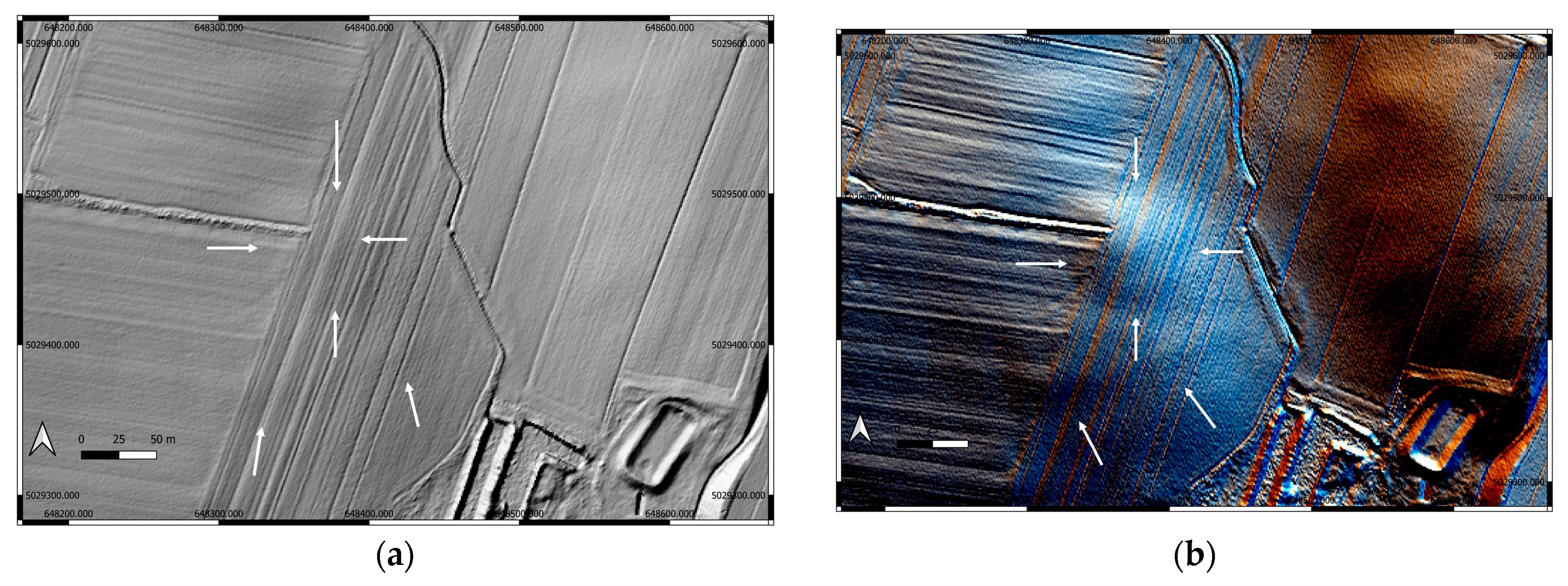
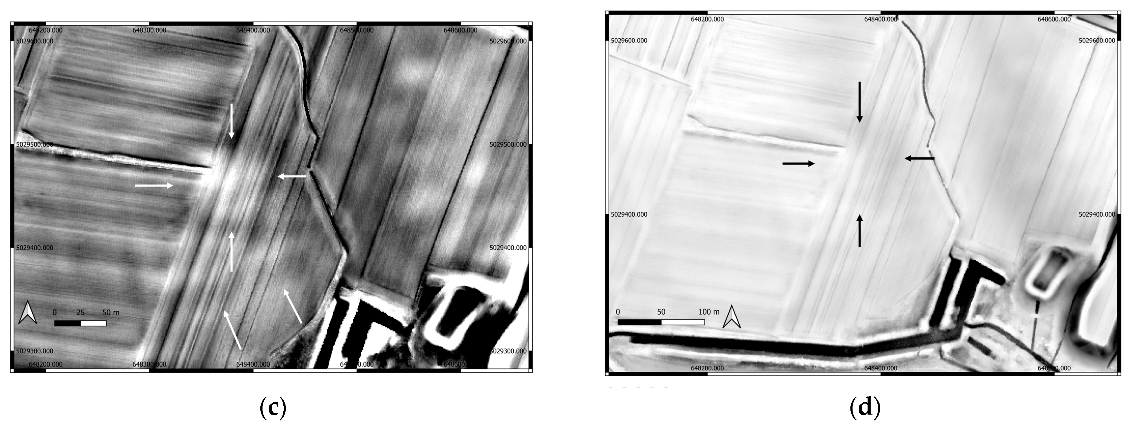
LiDAR data visualization produces a fundamentally different type of information compared to satellite and aerial imagery, resulting in distinctive patterns in the detection of archeological features. While satellite images and orthophotos are effective at highlighting surface-visible features, crop marks, and vegetation anomalies, LiDAR excels at revealing subtle micro-topographic changes—even those obscured by vegetation or those difficult to perceive at ground level. Here we present three different visualizations: Hillshade, multi-direction Hillshade, and a simple local relief model (Figure 11).
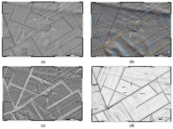
Figure 11.
Different visualization of LiDAR data of the site Markušica: (a) analytical Hillshade; (b) multi-direction Hillshade, 16 35. (c) Simple local relief model, R 20. (d) Sky view factor D20, R32, 8bit. Relief Visualization toolbox Plugin for QGIS. On all visualizations, vertical exaggeration is 8.
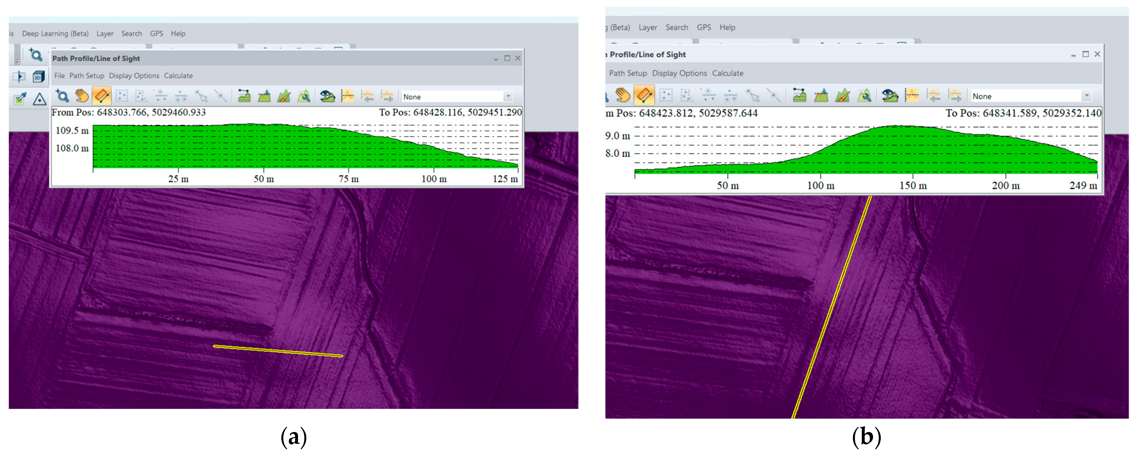
At the Markušica 1 site, the rondel is not visible in LiDAR visualization layouts (possibly because of the resolution of 4 pt/m2); without prior knowledge of its location, its presence would remain undetected on most rendered surfaces. However, analysis of LiDAR elevation profile paths reveals micro-topographic differences that hint at the rondel’s structure, although these variations are so subtle that precise localization remains challenging without correlating with external data (Figure 12).

Figure 12.
Path profiles of Markušica 1 rondels in Global Mapper, visualized using REM shader. (a) North–south profile; (b) west–east profile. Subtle changes in the topography are visible on the path profile and the position of the ditches. The highest elevation is in the middle part of the rondel.
Similarly, the large ellipsoidal ditches at Markušica—along with the second rondel—are mostly inconspicuous in standard LiDAR visualizations (Figure 13). However, the area enclosed by the both outer and inner rondel’s ditches displays a clear ellipsoid elevation, making the shape of the outer and central enclosure visible through relief modeling. In particular, simple local relief models generated from LiDAR data clearly show that the lowest elevations correspond to zones where double ditches occur, supporting archeological interpretation based on subtle terrain modifications (Figure 11c).

Figure 13.
Path profile of ellipsoidal enclosure and rondel 2 in Global Mapper, visualized using REM shader. (a) Profile of the ditches and the rondel; (b) profile of the southern part.
3.1.6. Geomagnetic Survey
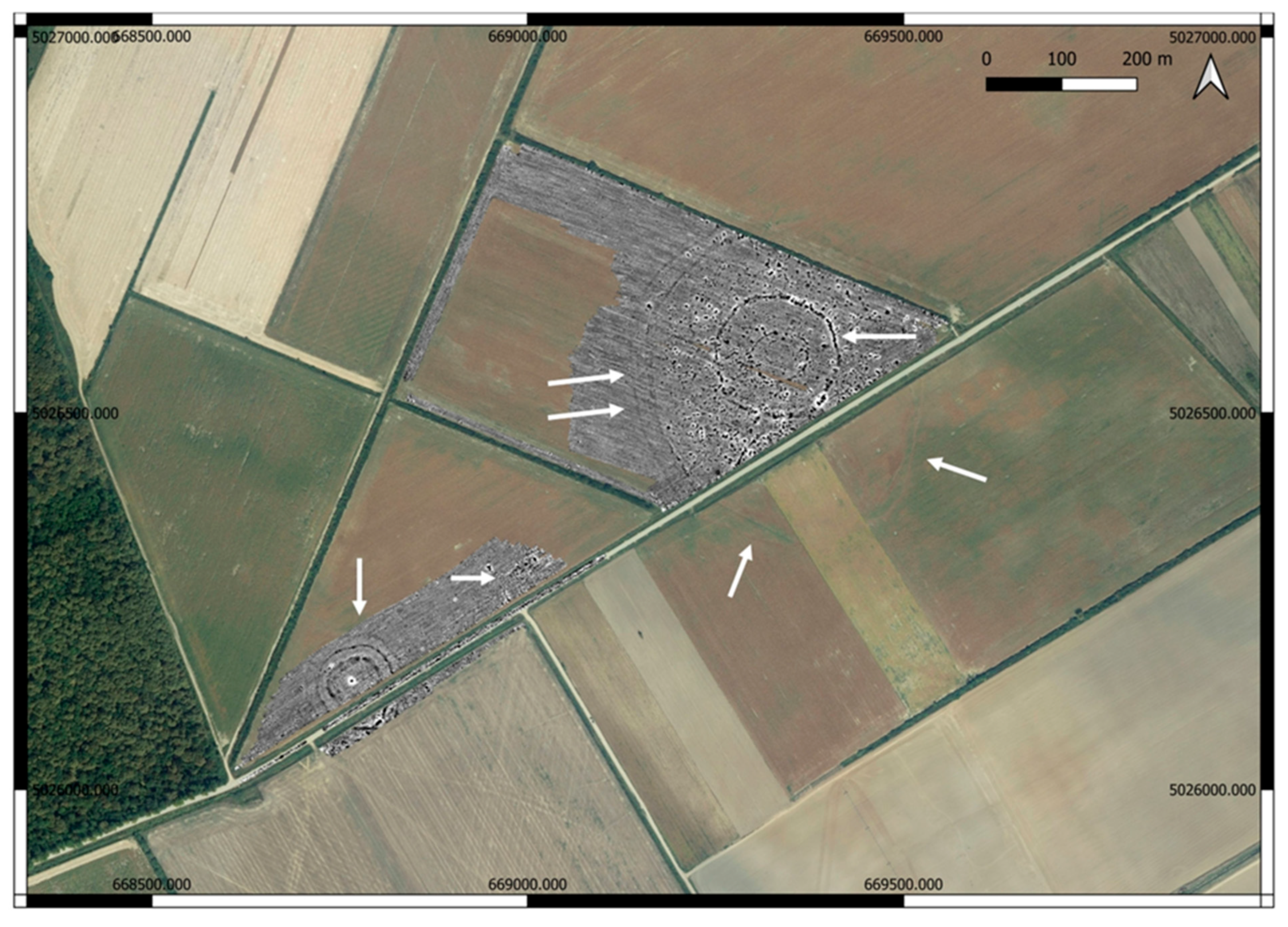
A geomagnetic survey of site Markušica was performed in April 2025 by the authors. It covered an area of 14 hectares (Figure 14).
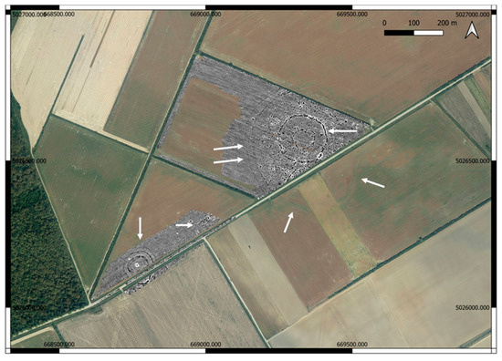
Figure 14.
Magnetogram of Markušica site on orthophoto image Geportal 2017. Source: Geoportal.dgu.hr (accessed on 2 July 2025).
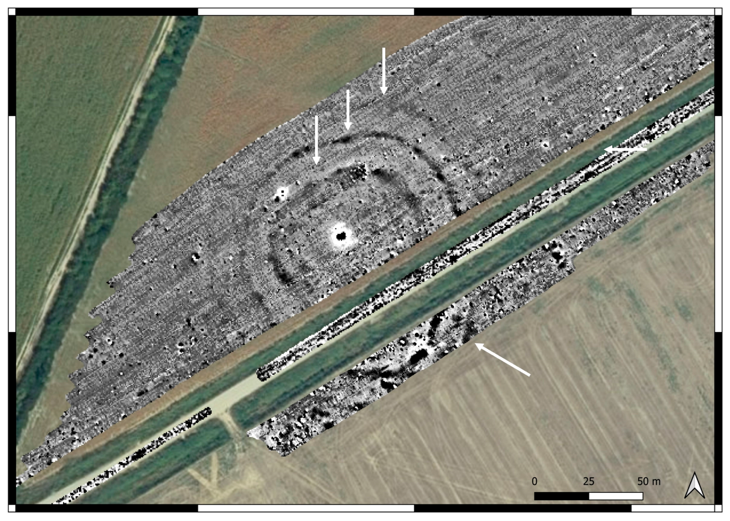
The prospection recorded numerous, mostly positive anomalies that represent archeological features. At the location of the Markušica 1 site, there were positive anomalies in the shape of four mostly circular ditches (Figure 15); at the location of the Markušica 2 site, there were positive anomalies forming two large ellipsoidal ditches and two circular ditches in the central part. Besides that, positive anomalies that could be interpreted as pits and burnt areas are present between the large ditches and the central one (Figure 14). Also, similar anomalies can be found between Markušica 1 and 2, areas that are not recognized by previous research but could both be interpreted as parts of the settlement area.
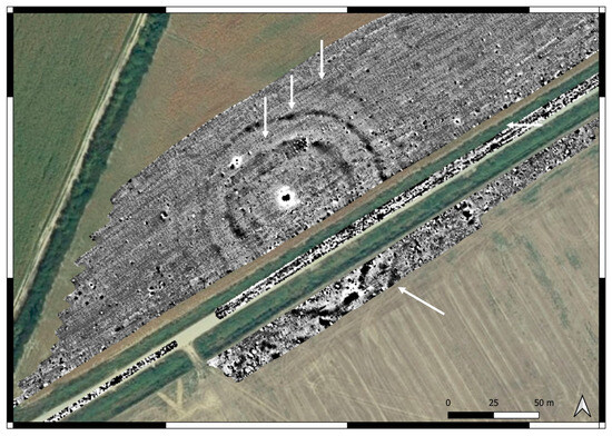
Figure 15.
Magnetogram of Markušica 1’s rondel.
Positive anomalies of the ditch are surrounded partially by negative anomalies, which can be remains of the preparation and stabilization of the ditches at the time of their construction.
Markušica 2’s rondel is very simple, consisting of two circular ditches with four entrances (Figure 14).
3.2. Gorjani Topole
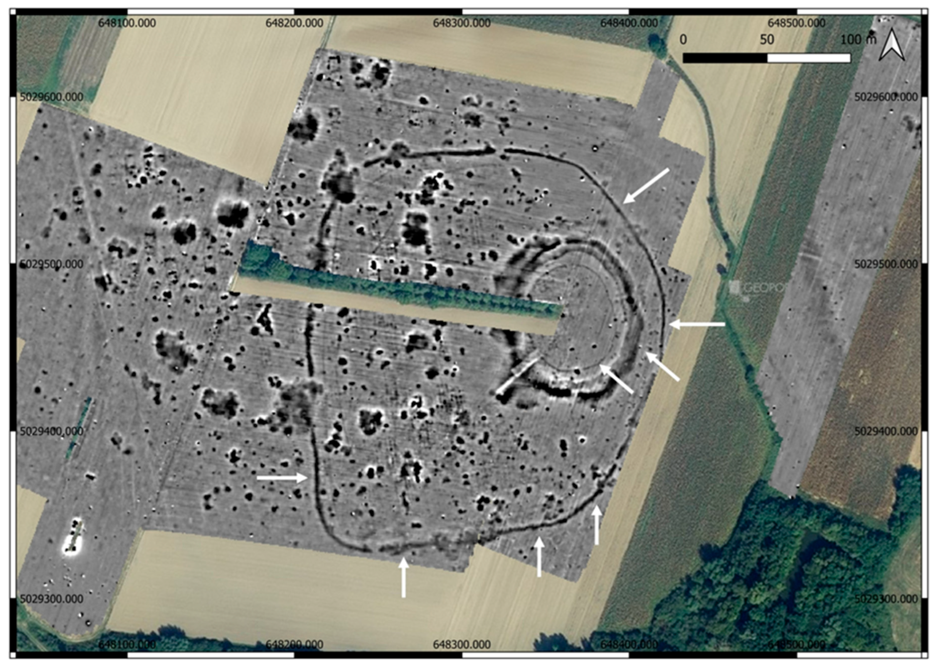
The Gorjani site also features a confirmed rondel, which exhibits an ellipsoidal shape formed by two ditches and a palisade. The inner part of this enclosure is almost devoid of archeological features. The outer ditch at Gorjani measures about 100 by 89 m.
3.2.1. Satellite Images and Geomagnetic Survey
Since the detailed description of the Gorjani Topole rondel analysis of satellite and drone images and magnetic survey was previously published [15], here we present only crucial information for the comparison with the Markušica rondels and results of LiDAR data analysis.
The rondel was observed on the earliest satellite images on Google Earth, dated 23 August 2007, where parts of three ditches are visible. On later Google Earth images, the ditches are less clearly visible, but the circular area can still be distinctly recognized as darker compared to the surrounding ground. In a similar way (Figure 16), it can be seen on aerial photographs available on the Geoportal (2011, 2014–2016, 2017), as well as in drone and airplane surveys ([15] Figure 6, Figure 7, Figure 8, Figure 9 and Figure 10), [12].
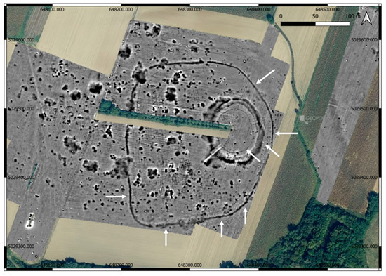
Figure 16.
Magnetogram of Gorjani Topole (measurements made by C. Meyer) on orthophoto image, Geportal 2017. Source: Geoportal.dgu.hr. (accessed on 12 July 2024).
On historical maps, there are no distinctive elements that would point out the presence of the rondel in the topography or the factors that could significantly impact its visibility.
3.2.2. LiDAR Data Analysis
We used the same visualizations as for the Markušica site. Here, the rondel is visible as a circular elevation with the highest point in the middle, and the remains of the outer ditch are visible on the southern side (Figure 17 and Figure 18).
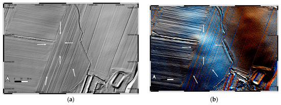
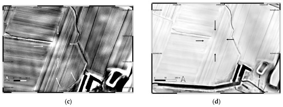
Figure 17.
Different visualization of LiDAR data of the site Gorjani Topole: (a) analytical Hillshade; (b) multi-direction Hillshade, 16 35. (c) Simple local relief model, R 20. (d) Sky view factor D20, R32, 8bit. Relief Visualization toolbox Plugin for QGIS. On all visualizations, vertical exaggeration is 8.
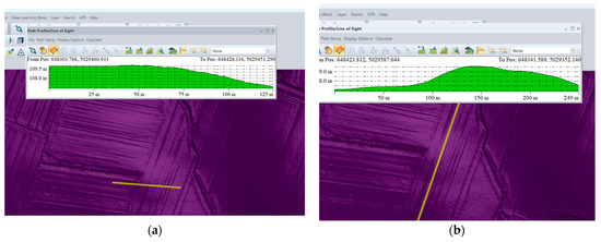
Figure 18.
Path profile of Gorjani Topole in Global Mapper: (a) profile N-S; (b) profile W-E.
4. Discussion
This research provided valuable information and guidelines about the rondels’ site interpretation and evaluation.
The southern portion of the Markušica 1 rondel is not visible in satellite imagery nor LiDAR data, yet it is clearly present in the geomagnetic survey (magnetogram). The magnetogram reveals that the ditches on the southern side form a unique tear-like shape that is rare among known rondels [3,4]. This feature’s visibility on just one satellite image from 2006 and a drone image, and faintly on a 690 nm spectral image (due to shading differences), underscores the importance of combining multiple remote sensing methods. Without geophysical survey data, this part of the rondel would likely be misinterpreted because the northern ditches suggest a circular or ellipsoidal shape of the enclosure.
The dimensions of the ditches are consistent across satellite images, crop and soil marks, and magnetic data. The two outer ditches measure approximately 7 to 7.5 m in width, while the inner ditch is about 12 m wide. However, the innermost ditch of the Markušica 1 rondel appears wider visually on satellite images than on the magnetogram, demonstrating how different sensing techniques can yield varying perceptions of feature dimensions.
Within the ditches of the western rondel and inside the smaller rondel embedded within the larger eastern ditches, the interior areas show mostly empty space with very few archeological features detected.
The geomagnetic survey matches well with the interpretation from satellite and aerial imagery, where initially four ditches were identified, the innermost being the widest. Though the fourth ditch is faint in both satellite images and magnetograms, its presence in magnetometry data vouches for its interpretation.
Spectral differences sometimes appear between larger and smaller ditches on the same imagery, particularly noticeable in near-infrared-like bands, highlighting possible variations in soil moisture or vegetation linked to subsurface remains.
Continuous agricultural plowing over centuries has likely contributed to the degradation and partial invisibility of specific parts of the site, such as the missing southern features and the lack of topographical changes in the very flat environment. Agricultural activity remains a dynamic and ongoing factor, making comprehensive preservation or visibility difficult to attain for sites like Markušica.
Historical aerial imagery from 1968 suggests that part of the southern ditch may still have had a visible function or presence into the mid-20th century, a pattern noted at other regional sites where ditches have endured as landscape boundaries.
In contrast to Markušica, Gorjani displays almost the opposite visibility pattern in satellite and aerial images. Here, the ditches themselves are rarely visible. Instead, the entire rondel area outlines a distinctive dark ellipsoid, despite its interior being almost featureless archeologically. Notable differences in morphology between these sites also exist:
The Gorjani rondel’s inner ditch is narrower, accompanied by preserved palisade remains, unlike the wider ditches at Markušica 1. The inner space in Gorjani is much bigger than Markušica 1. There is a striking similarity in the ratio of length to width between the two sites, indicating potential shared planning principles despite differences in size and preservation. Despite subtle elevation changes at Markušica 1, it and Gorjani share the characteristic of having the highest topographic point located centrally within the rondel, emphasizing their assumed designed spatial organization amid differing preservation conditions.
Markušica 1 and 2 and Gorjani represent three very similar but distinct Neolithic rondels that today appear quite different in the landscape due to variations in morphology, preservation, archeological content, and modern disturbance. This contrast highlights the challenges and potential of multi-method remote sensing and site interpretation in complex archeological landscapes.
Surrounding all three rondels site, archeological features are densely present, suggesting a complex landscape.
The integration of multiple geophysical and remote sensing methods has yielded significant interpretative results for these sites, identifying features otherwise invisible to standalone techniques. However, no single method provides a complete picture of the site’s entirety, underscoring the need for combined methodologies.
Subtle topographic changes, such as those near modern roads bisecting the site, challenge the visualization of elevation differences, especially in LiDAR profile paths.
This observation and the complex nuances show that this research goes well beyond the local significance and has wider implications for archeological research:
- Diversity and variability of Neolithic enclosures: The contrast between Markušica 1 and 2 and Gorjani rondels highlights the architectural diversity within the Neolithic rondel phenomenon across Central and Southeastern Europe. Differences in ditch dimensions, ditch visibility, internal archeological features, and topographic expression emphasize that rondels were not uniform structures but varied according to cultural choices, local landscape conditions, and possible differing functions (ritual, social, or territorial). This supports recent research portraying rondels as multi-functional socio-cultural centers rather than solely defensive or astronomical monuments.
- Impact of post-depositional and modern factors: The marked differences in preservation and visibility demonstrate how centuries of human activity such as agriculture, road construction, and land parceling shape the modern archeological record. These results remind us to carefully integrate historical land use and natural landscape dynamics when interpreting prehistoric sites, especially those with subtle topography like rondels.
- Importance of integrated multi-method remote sensing: This study shows how combining geomagnetic surveys with LiDAR and multi-spectral satellite imagery greatly improves detection of faint or obscured archeological features. The inability of any single method to fully reveal complex earthworks underlines the necessity of integrated prospection strategies in landscape archeology, serving as a model for investigating similar subtle and disturbed prehistoric enclosures beyond the study region.
- Spatial organization and monumentality in Neolithic communities: The shared spatial pattern of central elevation and multiple concentric ditches at both sites, despite differences in landscape expression and preservation, suggests common symbolic or social structuring principles among Neolithic communities in this region. This may inform broader debates on how early farming societies organized their ceremonial and territorial landscapes.
- Guiding future research and conservation: Insights from Markušica rondels and Gorjani provide practical guidance on survey methodologies, data interpretation, and site management in regions with complex multi-temporal land use histories. They highlight the need for nuanced visualization and analytical workflows to avoid underestimating or mischaracterizing archeological heritage [34].
While Central European rondels are widely interpreted as multi-functional ritual enclosures with territorial and social functions (for example, Lower Austria), the analyzed sites in this paper, and majority of the southern Carpathian Basin, given their architectural distinctions and landscape setting, may reflect localized adaptations or variations in social organization and land use practice. They also seem to be used as settlements and through prolonged periods of time.
At Markušica 1, the presence of four concentric ditches aligns well with this Central European “norm”, indicating a complex enclosure structure. However, Gorjani exhibits fewer and more fragmented ditches, suggesting either a simpler or more eroded monument or a different type of enclosure altogether, which may reflect local variations in construction style or preservation state.
Entrance orientation at the studied sites is more variable or difficult to discern compared to the mostly regular orientations found in Central European rondels, possibly due to differential preservation or cultural differences in site design.
These results contribute significantly to the growing body of knowledge on Neolithic rondels and other earthworks in Europe, advancing methodological standards for remote sensing-based archeological prospection and enriching interpretations of prehistoric social landscapes under changing environmental and cultural conditions.
5. Conclusions
This research highlights the multi-method integration of magnetic prospection, LiDAR, and aerial and satellite image analysis while using publicly available data in advancing the robust identification and evaluation of Neolithic rondels in Eastern Croatia, while underscoring wider methodological and interpretative implications within European archeological research.
This research demonstrates that the synergistic application of geomagnetic prospection, LiDAR data, and aerial/satellite imagery not only facilitates more accurate recognition of rondel structures but also reveals complex aspects of their morphology, landscape integration, and preservation that remain invisible to singular methods. This multi-scalar approach enabled confirmation of diagnostic features, nuanced mapping of ditches and palisades, and comparative analysis of visibility and preservation across the studied sites.
Integrated, non-invasive prospection strategies are indispensable for investigating subtle or disturbed prehistoric earthworks like rondels, especially within heavily modified agricultural landscapes. No single method, whether magnetic prospection, LiDAR, or satellite and aerial imagery analysis, captures the full archeological complexity; their combination overcomes individual limitations, enabling detection of features unrecognized by surface observation and strengthening the reliability of interpretations.
These results reinforce the effectiveness and reliability of publicly available remote sensing datasets for large-scale site detection, suggesting that similar integrated frameworks should be adopted more widely across Central and Southeastern Europe where there is constantly growing data [4,35,36,37]. The observed architectural variability and preservation differences between Markušica 1 and Gorjani rondels highlight the diversity inherent in Neolithic monumental landscapes, with implications for understanding ritual, social, and territorial aspects of prehistoric communities.
The tear-like form of the Markušica 1 outer ditch is rare among documented Central European rondels. Its presence and partial invisibility in both LIDAR and most aerial imagery, versus clear visibility in geomagnetic data, raise questions about how monumentality, site layout, and post-depositional impacts affect detection and interpretation. The functional, symbolic, or chronological significance of such non-standard plan types remains to be explored.
Holistic, multi-method workflows should become standard practice for future archeological prospection, especially in regions with complex land use histories.
The methodology presented here is not only sufficient for confident identification and assessment of Neolithic rondels but it also represents a model for landscape-scale archeological research. By leveraging the strengths of remote sensing and geophysical analysis in tandem, this study significantly advances the standards for detection, interpretation, and understanding of prehistoric monumental sites contributing valuable insights to the broader field of European prehistoric archeology.
Author Contributions
Conceptualization, H.K., B.Š., and R.Š.K.; methodology, B.Š., H.K., and R.Š.K.; investigation, R.Š.K., B.Š., and H.K.; resources, R.Š.K., B.Š., and H.K.; writing—original draft preparation, R.Š.K., B.Š., and H.K.; writing—review and editing, H.K., B.Š., and R.Š.K.; funding acquisition, R.Š.K., H.K., and B.Š. All authors have read and agreed to the published version of the manuscript.
Funding
This research was funded by CROATIAN SCIENCE FOUNDATION, grant number IP-2024-05-1598.
Data Availability Statement
The original contributions presented in this study are included in the article. Further inquiries can be directed to the corresponding author.
Acknowledgments
We are grateful for the support during our fieldwork research of Ivan Lović, municipality of Gorjani, Tomislav Hršak—Archaeological Museum Osijek, Maja Krznarić Škrivnko—City Museum Vinkovci, and students of archeology from the University of Zagreb Borna Sabljak, Mislav Godanj, Karla Vujčić, Jan Nikolić, and Lovro Vragolović.
Conflicts of Interest
The authors declare no conflicts of interest.
References
- Vondrovský, V.; Kovačiková, L.; Smejtek, L. Neolithic rondels in central Europe and their builders: An analysis of multi-rondel sites. Antiquity 2022, 96, 1105–1123. [Google Scholar] [CrossRef]
- Schier, W. (Ed.) Recent Research on Neolithic Circular Enclosures in Central Europe 5000-4500 cal. BC; Marie Leidorf: Rahden, Germany, 2023. [Google Scholar]
- Literski, N.; Nebelsick, L.D. Katalog der Kreisgrabenanlagen und verwandten Tells der ersten Hälfte des 5. Jt. v. Chr. In Mittel- und Südosteuropa. In Neolithische Kreisgrabenanlagen in Europa. Internationale Arbeitstagung 7.-9. Mai 2004 in Goseck (Sachsen-Anhalt); Bertemes, F., Meller, H., Eds.; Landesamt für Denkmalpflege und Archäologie Sachsen-Anhalt: Halle (Saale), Germany, 2012; pp. 433–532. [Google Scholar]
- Řídký, J.; Květina, P.; Limburský, P.; Končelová, M.; Burgert, P.; Šumberová, R. Big Men or Chiefs? Rondel Builders of Neolithic Europe; Oxbow Books: Oxford, UK; Philadelphia, PA, USA, 2018. [Google Scholar]
- Petrasch, J. Central European Enclosures. In The Oxford Handbook of Neolithic Europe; Fowler, C., Harding, J., Hofmann, D., Eds.; Oxford University Press: Oxford, UK, 2014; pp. 763–778. [Google Scholar]
- Wroniecki, P.; Furmanek, M.; Rączkowski, W. Revealing the extent of Neolithic rondel enclosures in Lower Silesia using non-invasive prospection. Antiquity 2023, 97, 1100–1118. [Google Scholar] [CrossRef]
- Řídký, J.; Květina, P.; Půlpán, M.; Kovačiková, L.; Stolz, D.; Brejcha, R.; Šreinová, B.; Šrein, V. Analýza a interpretace nálezů z příkopu neolitického rondelu ve Vchynicích (okr. Litoměřice). Archeologické Rozhledy 2012, 64, 628–694. [Google Scholar]
- Řídký, J.; Květina, P. Rondels and interpretation of the patchy evidence across the rondel regions. In Recent Research on Neolithic Circular Enclosures in Central Europe 5000-4500 cal. BC; Schier, W., Ed.; Marie Leidorf: Rahden, Germany, 2023; pp. 357–373. [Google Scholar]
- Opitz, R.S.; Cowley, D.C. Interpreting Archaeological Topography: 3D Data, Visualisation and Observation; Oxbow Books: Oxford, UK, 2013. [Google Scholar]
- Johnson, K.M.; Ouimet, W.B. An Observational and Theoretical Framework for Interpreting the Landscape Palimpsest through Airborne LiDAR. Appl. Geogr. 2018, 91, 32–44. [Google Scholar] [CrossRef]
- De Smedt, P.; French, C.; Kinnaird, T.; Rajkovača, T.; Milekić, A.; Chatzimpaloglou, P.; Verhegge, J.; Hermans, T.; Veirana, G.M.; Obradović, D.; et al. An integrated geoarchaeological approach to the investigation of multi-period prehistoric settlements—The case of Neolithic Drenovac. In Advances in on- and Offshore Archaeological Prospection: Proceedings of the 15th International Conference on Archaeological Prospection; Universitätsverlag Kiel|Kiel University Publishing: Kiel, Germany, 2023; pp. 111–114. [Google Scholar] [CrossRef]
- Hofmann, R.; Furholt, K.; Medović, A.; Furholt, M.; Wilkes, F.; Medović, I.; Stanković-Pešterac, T.; Kühl, T.; Schultrich, S.; Ramadanski, R.; et al. Neolithic settlement structures on the lower reaches of the River Tisza (Vojvodina, Serbia): The results of archaeo-magnetic prospection. In Beyond Heterogenities. New Perspectives on Social and Cultural Diversity from the Neolithic to the Bronze Age in the Carpathian Basin; Furholt, K., Depaermentier, M.L.C., Kemp, M., Furholt, M., Eds.; Scales of Transformation 21; Sidestone Press Academics: Leiden, The Netherlands, 2025; pp. 121–153. [Google Scholar]
- Győri, J.; Gyucha, A.; Szalma, B.; Szalma, E.; Stibrányi, M.; Pethe, M.; Fischl, K.P. Non-destructive investigations at Neolithic tell-centered settlement complexes on the Great Hungarian Plain: A case study from Battonya-Parázs-tanya [Roncsolásmentes kutatási módszerek alkalmazása egy alföldi, késő neolitikus, tell-központú településkomplexum vizsgálatára. Esettanulmány: Battonya-Parázs-tanya]. Archaeol. Ért. 2024, 149, 1–20. [Google Scholar] [CrossRef]
- Kalafatić, H.; Šošić Klindžić, R.; Šiljeg, B. Being Enclosed as a Lifestyle: Complex Neolithic Settlements of Eastern Croatia Re-Evaluated through Aerial and Magnetic Survey. Geosciences 2020, 10, 384. [Google Scholar] [CrossRef]
- Šošić Klindžić, R.; Šiljeg, B.; Kalafatić, H. Multiscale and Multitemporal Remote Sensing for Neolithic Settlement Detection and Protection—The Case of Gorjani, Croatia. Remote Sens. 2024, 16, 736. [Google Scholar] [CrossRef]
- Google Earth. Available online: https://earth.google.com (accessed on 22 February 2025).
- Geoportal.dgu.hr. Available online: https://geoportal.dgu.hr/ (accessed on 20 February 2025).
- Šiljeg, B.; Kalafatić, H. Zračna arheologija u istočnoj Slavoniji 2014. Godine. Ann. Inst. Archaeol. 2015, 11, 135–141. Available online: https://hrcak.srce.hr/148455 (accessed on 3 April 2025).
- Šiljeg, B.; Kalafatić, H. Zračno rekognosciranje, Osječko baranjska županija 2015. godine. Ann. Inst. Archaeol. 2016, 12, 213–222. Available online: https://hrcak.srce.hr/167349 (accessed on 3 April 2025).
- Šiljeg, B.; Kalafatić, H. Zračno rekognosciranje u istočnoj Slavoniji 2016. godine. Ann. Instituti Archaeol. 2017, XIII, 168–173. Available online: https://hrcak.srce.hr/189499 (accessed on 3 April 2025).
- Fassbinder, J.W.E. Magnetometry for Archaeology. In Encyclopedia of Geoarchaeology; Gilbert, A.S., Goldberg, P., Mandel, R.D., Aldeias, V., Eds.; Encyclopedia of Earth Sciences Series; Springer: Cham, Switzerland, 2023. [Google Scholar] [CrossRef]
- Meylemans, E.; De Smedt, P. (Eds.) De Toepassing van Geofysische Prospectie Methoden in de Archeologie The Use of Geophysical Prospection Methods in Archaeology; Onderzoeksrapporten agentschap Onroerend Erfgoed 118; Onroerend Erfgoed: Brussels, Belgium, 2019. [Google Scholar]
- Verhegge, J.; Mendoza Veirana, G.; Cornelis, W.; Crombé, P.; Grison, H.; de Kort, J.-W.; Rensink, E.; De Smedt, P. Developing a geophysical framework for Neolithic land-use studies: In situ monitoring and forward modelling of electrical properties at “Valther-Tweeling” (NL). In Advances in on- and Offshore Archaeological Prospection: Proceedings of the 15th International Conference on Archaeological Prospection; Universitätsverlag Kiel|Kiel University Publishing: Kiel, Germany, 2023; pp. 399–403. [Google Scholar] [CrossRef]
- Schmidt, A.; Linford, P.; Linford, N.; David, A.; Gaffney, C.; Fassbinder, J.W.E.; Sarris, A. EAC Guidelines for the Use of Geophysics in Archaeology: Questions to Ask and Points to Consider; Europae Archaeologiae Consilium: Brussels, Belgium, 2015. [Google Scholar]
- Meyer, C. Magnetic Prospection at the Neolithic Sites of Kremenjača and Topola Gorjani, Osijek-Baranja County, Croatia; Technical Field Report; University of Zagreb: Zagreb, Croatia, 2021. [Google Scholar]
- CSGA, LIDAR. Available online: https://dgu.gov.hr/UserDocsImages/dokumenti/Istaknute%20teme/Multisenzorno%20snimanje/LiDAR%20snimanje%20iz%20zraka.pdf (accessed on 13 March 2025).
- Kokalj, Ž.; Somrak, M. Why Not a Single Image? Combining Visualizations to Facilitate Fieldwork and On-Screen Mapping. Remote Sens. 2019, 11, 747. [Google Scholar] [CrossRef]
- Kokalj, Ž.; Čonč, K. QGIS Relief Visualisation Toolbox Plugin: AARG Online Workshop, 25 May 2023. 2023. Available online: https://www.researchgate.net/publication/371226392_QGIS_Relief_Visualisation_Toolbox_plugin_AARG_Online_workshop_25_May_2023 (accessed on 23 July 2024).
- Zakšek, K.; Oštir, K.; Kokalj, Ž. Sky-View Factor as a Relief Visualization Technique. Remote Sens. 2011, 3, 398–415. [Google Scholar] [CrossRef]
- Bennett, R.; Cowley, D.; Gaffney, C.; Opitz, R.; Rášová, A.B.; Zerboni, A.; Corns, A.; Russell, A.; Villarejo, A.J.O.; Mann, B.; et al. Guidelines for the Use of Airborne Laser Scanning (Lidar) in Archaeology (EAC Guidelines 10); European Archaeological Council: Brussels, Belgium, 2025. [Google Scholar] [CrossRef]
- Filip-Gherman, M.; Bruma, S.; Sabou, C.; Nap, M.; Suba, E.-E.; Sălăgean, T. The cross-disciplinary influence of aerial measurement techniques: Exploring archaeological studies through photogrammetry and LiDAR. Nova Geod. 2024, 4, 154. [Google Scholar] [CrossRef]
- Arcanum. Arcanum Maps [WWW Document]. Available online: https://maps.arcanum.com/en/ (accessed on 23 February 2025).
- Krznarić Škrivanko, M. Prostorna distribucija i unutarnja organizacija naselja sopotske kulture na Vinkovačkom području. Archaeol. Adriat. 2024, 18, 141–227. [Google Scholar] [CrossRef]
- Opitz, R.; Baldwin, E.; De Smedt, P.; Verhegge, J.; Campana, S.; Mayoral-Herrera, V.; Powlesland, D.; Vieri, M.; Perna, C.; Sarri, D. Remote Sensing Data to Support Integrated Decision Making in Cultural and Natural Heritage Management. Impasses and opportunities for collaboration in agricultural areas. Internet Archaeol. 2023, 62. [Google Scholar] [CrossRef]
- Sarris, A.; Papadopoulos, N.; Urem-Kotsou, D.; Oikonomou, D.; Sgouropoulos, K.; Chrysafakoglou, P.; Karadima, C.; Chrysaphi, M. Deciphering Neolithic Habitation in Aegean Thrace Through Geophysical Prospection Surveys. Archaeol. Prospect. 2025, 1–16. [Google Scholar] [CrossRef]
- Hofmann, R.; Furholt, M.; Medović, I.; Stanković Pešterac, T.; Medović, A.; Dreibrodt, S.E.E.; Wilkes, F.; Martini, S.; Staniuk, R.; Furholt, K. Strategy and Results of Ten Years Interdisciplinary Fieldworks at the Late Neolithic Multi-Component and Multi-Period Settlement Borđoš. In Project Borđoš: Ten Years of Research; Pešterac, T.S., Ed.; Museum of Vojvodina: Novi Sad, Serbia, 2024; pp. 41–104. [Google Scholar]
- Savić, R.; Obradović, Đ.; Meyer, C. Geophysical prospection at the Neolithic site of Stublina-Supska, Serbia. In The Neolithic in the Middle Morava Valley: Late Neolithic Strategies; Institute of Archaeology: Belgrade, Serbia, 2025; No 4; pp. 147–160. [Google Scholar]
Disclaimer/Publisher’s Note: The statements, opinions and data contained in all publications are solely those of the individual author(s) and contributor(s) and not of MDPI and/or the editor(s). MDPI and/or the editor(s) disclaim responsibility for any injury to people or property resulting from any ideas, methods, instructions or products referred to in the content. |
© 2025 by the authors. Licensee MDPI, Basel, Switzerland. This article is an open access article distributed under the terms and conditions of the Creative Commons Attribution (CC BY) license (https://creativecommons.org/licenses/by/4.0/).

