Deep Learning-Based Contrail Segmentation in Thermal Infrared Satellite Cloud Images via Frequency-Domain Enhancement
Abstract
Highlights
- MFcontrail is proposed, a deep learning model integrating multi-axis attention and frequency-domain enhancement for contrail segmentation in thermal infrared satellite images.
- MFcontrail outperforms state-of-the-art methods (e.g., DeepLabV3+), achieving +5.03% F1-score on OpenContrails and +3.43% F1-score on Landsat-8 datasets.
- Frequency-domain enhancement contributes 69.4% of IoU improvement, effectively preserving fine contrail edge details.
- Provides a high-precision tool for contrail segmentation, supporting aviation climate research relying on accurate thermal infrared satellite image analysis.
- Validates the effectiveness of frequency-domain strategies in satellite cloud analysis, offering insights for similar fine-grained remote sensing segmentation tasks.
Abstract
1. Introduction
- A Max-ViT/U-Net hybrid segmentation architecture: The MaxViT backbone network is used to realize synergistic feature extraction with multi-axis block/grid attention and convolution, which captures the global context while preserving the local receptive field, and combined with the U-Net skip connection to realize multi-scale feature fusion.
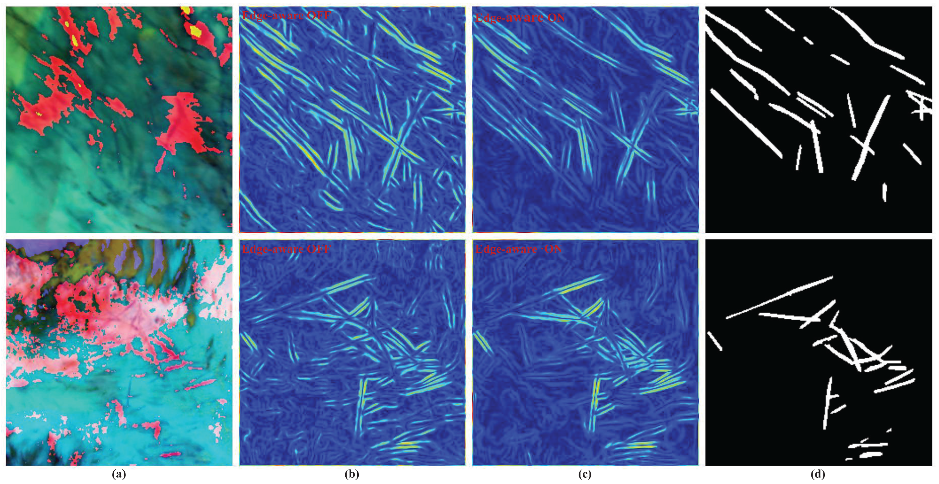
- An edge-aware composite loss function: This joint boundary-sensitive loss enhances gradient direction consistency and local phase alignment, improving pixel-level edge localization accuracy.
- A frequency analysis-based feature fusion framework, FreqFusion, is introduced, which addresses the loss of high-frequency details in boundary regions caused by traditional upsampling techniques (e.g., bilinear interpolation) and enhances pixel-level edge localization accuracy.
2. Datasets
2.1. Landsat-8 Contrails Dataset
2.2. OpenContrails Dataset
2.3. Model Validation Method
3. Methods
3.1. Color Projection
- 1.
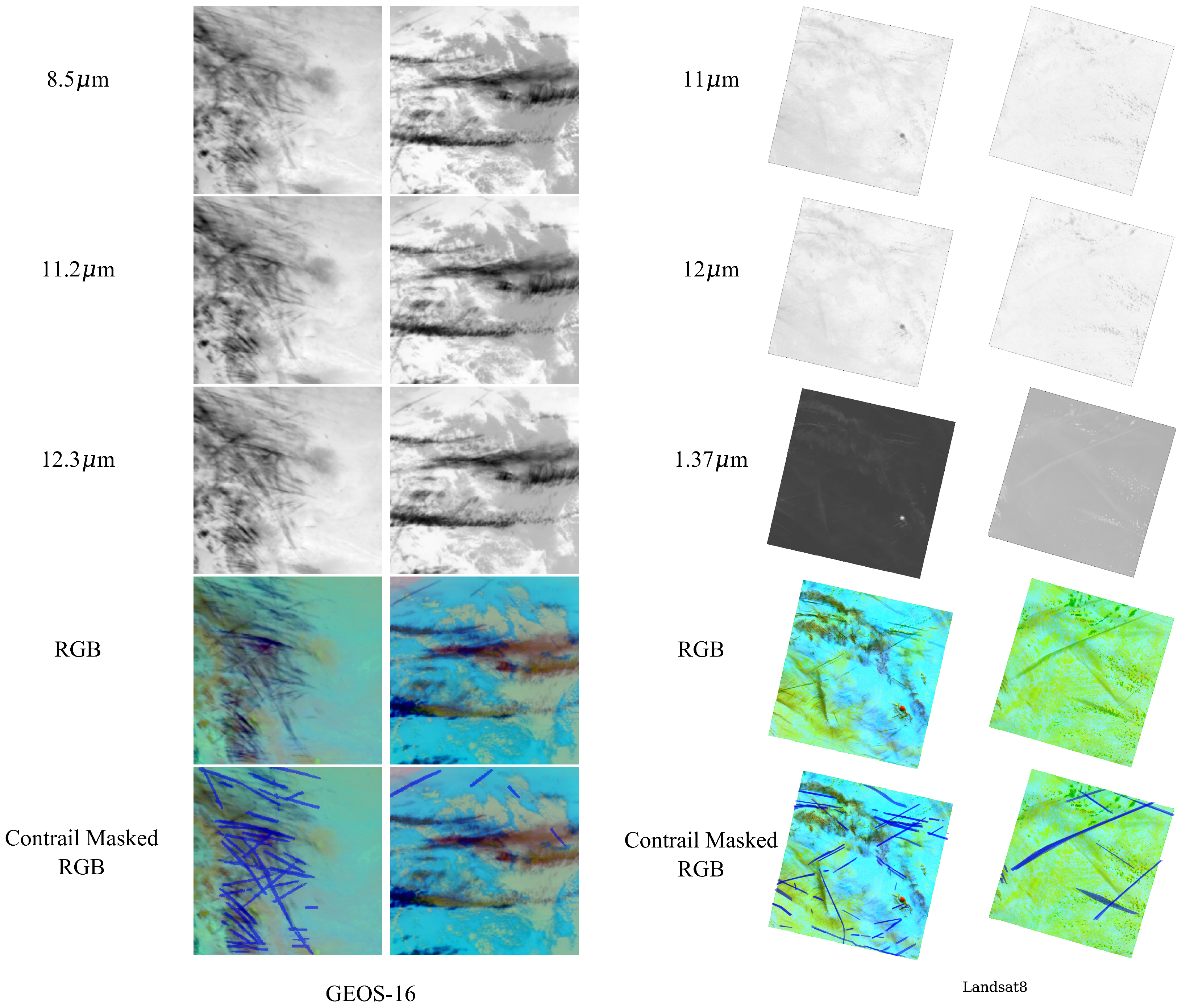
- Red Channel: Encodes the negative 11–12 μm brightness temperature difference (−ΔT), normalized to . Cold contrails (negative ) appear dark.
- 2.
- Green Channel: Leverages the 1.37 m cirrus band reflectance () for daytime scenes, using (normalized to ) to highlight ice particles. For nighttime, where the 1.37 m band lacks solar illumination, this channel is replaced with zeros to avoid noise artifacts.
- 3.
- Blue Channel: Represents a 12 m brightness temperature () normalized to K (day) or K (night), with contrails appearing as cold (dark) features.
3.2. MaxViT Encoder
3.3. FreqFusion Decoder
- 1.
- FreqFusion Module: As shown in Figure 1c, we use the FreqFusion module proposed in Chen et al.’s work [29]. Siamese 1 × 1 convolutions are applied to the two resolution inputs. The adaptive low-pass filter generator dynamically generates low-pass filters, avoiding boundary blurring caused by simple interpolation and better preserving high-frequency information, thereby improving feature consistency and boundary clarity. The adaptive high-pass filter generator enhances high-frequency components to recover boundary details lost in low-level features, combining low-level features with high-level semantics to significantly improve resolution in boundary regions. The offset generator calculates pixel similarity to generate offsets for resampling inconsistent regions, effectively reducing boundary blurriness and enhancing the model’s sensitivity to boundary information.
- 2.
- SCSE Module: As shown in Figure 1d, SCSE simultaneously recalibrates input features in spatial and channel dimensions. By element-wise addition of channel and spatial excitation, simultaneous Spatial and Channel Squeeze and Excitation (SE) is obtained. When input feature maps gain high importance from channel rescaling and spatial rescaling, they are assigned higher activation values. This recalibration encourages the network to learn more meaningful feature maps that are relevant in both spatial and channel dimensions.
3.4. Edge-Aware Loss
3.4.1. Edge Loss Formulation
3.4.2. Combined Loss Function
4. Experimental Conditions and Settings
4.1. Data Preprocessing
4.2. Evaluation Metrics
- Precision measures the model’s ability to avoid false alarms:
- Recall (sensitivity) quantifies the model’s capability to detect all relevant instances:
- F1-score balances precision and recall as their harmonic mean:
- Intersection over Union (IoU) evaluates spatial overlap between predicted and ground truth regions:
4.3. Model Comparison
4.4. Ablation Experiments
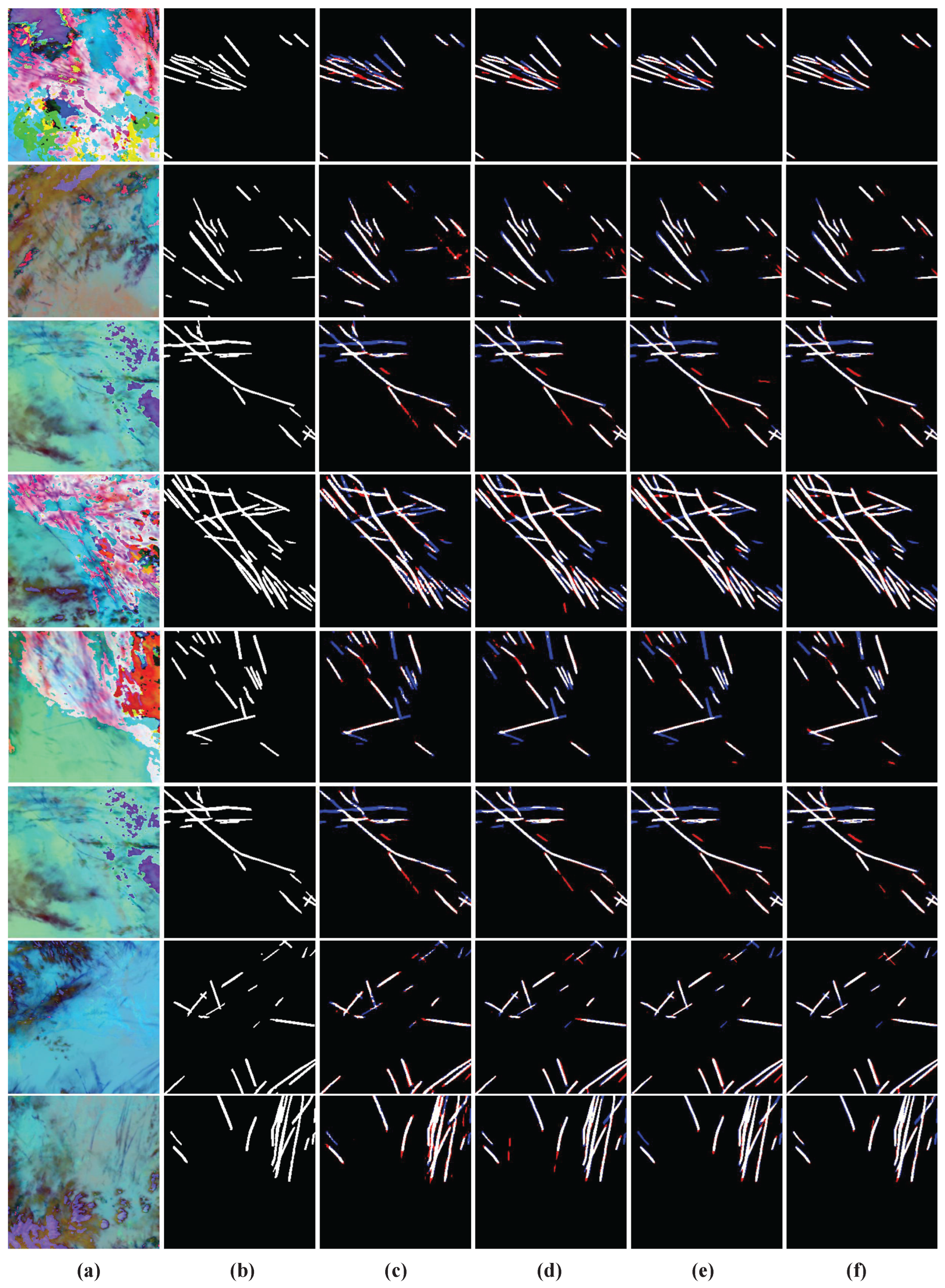
- Stage 1. Baseline: DeepLabV3+ with a ResNet152d-SE backbone, trained with cross-entropy loss.
- Stage 2. +FreqFusion Decoder: Replaced standard upsampling with the FreqFusion decoder, incorporating adaptive low- and high-pass filters for frequency-domain feature fusion.
- Stage 3. +MaxViT-Small Backbone: Substituted the ResNet152d-SE backbone with MaxViT-Small to enhance long-range dependency modeling.
- Stage 4. +Edge-aware Loss: Added the edge-aware loss, combining cross-entropy with gradient-domain matching (Equation (4)).
5. Result Analysis
5.1. Model Comparison Analysis
5.2. Ablation Study Analysis
5.3. Performance Significance
6. Discussion
6.1. Result Significance
6.2. Comparison with Existing Work
6.3. Limitations
6.4. Practical Applications
7. Conclusions
Author Contributions
Funding
Data Availability Statement
Acknowledgments
Conflicts of Interest
Abbreviations
| GOES | Geostationary Operational Environmental Satellite |
| ABI | Advanced Baseline Imager |
| IoU | Intersection over Union |
| MaxViT | Multi-axis Vision Transformer |
| BTD | Brightness Temperature Difference |
References
- Schumann, U. On conditions for contrail formation from aircraft exhausts. Meteorol. Z. 1996, 5, 4–23. [Google Scholar] [CrossRef]
- Immler, F.; Treffeisen, R.; Engelbart, D.; Krüger, K.; Schrems, O. Cirrus, contrails, and ice supersaturated regions in high pressure systems at northern mid latitudes. Atmos. Chem. Phys. 2008, 8, 1689–1699. [Google Scholar] [CrossRef]
- Kärcher, B. Formation and radiative forcing of contrail cirrus. Nat. Commun. 2018, 9, 1824. [Google Scholar] [CrossRef]
- Quaas, J.; Gryspeerdt, E.; Vautard, R.; Boucher, O. Climate impact of aircraft-induced cirrus assessed from satellite observations before and during COVID-19. Environ. Res. Lett. 2021, 16, 064051. [Google Scholar] [CrossRef]
- Bier, A.; Burkhardt, U. Impact of parametrizing microphysical processes in the jet and vortex phase on contrail cirrus properties and radiative forcing. J. Geophys. Res. Atmos. 2022, 127, e2022JD036677. [Google Scholar] [CrossRef]
- Märkl, R.S.; Voigt, C.; Sauer, D.; Dischl, R.K.; Kaufmann, S.; Harlaß, T.; Hahn, V.; Roiger, A.; Weiß-Rehm, C.; Burkhardt, U.; et al. Powering aircraft with 100% sustainable aviation fuel reduces ice crystals in contrails. Atmos. Chem. Phys. 2024, 24, 3813–3837. [Google Scholar] [CrossRef]
- Lee, D.; Fahey, D.; Skowron, A.; Allen, M.; Burkhardt, U.; Chen, Q.; Doherty, S.; Freeman, S.; Forster, P.; Fuglestvedt, J.; et al. The contribution of global aviation to anthropogenic climate forcing for 2000 to 2018. Atmos. Environ. 2021, 244, 117834. [Google Scholar] [CrossRef]
- Niklaß, M.; Lührs, B.; Swaid, M. Note on the Non-CO2 Mitigation Potential of Hybrid-Electric Aircraft Using “Eco-Switch”. J. Aircr. 2023, 60, 265–271. [Google Scholar] [CrossRef]
- Li, L.; Zhou, X.; Hu, Z.; Gao, L.; Li, X.; Ni, X.; Chen, F. On-orbit monitoring flying aircraft day and night based on SDGSAT-1 thermal infrared dataset. Remote Sens. Environ. 2023, 298, 113840. [Google Scholar] [CrossRef]
- Zhou, X.; Li, L.; Yu, J.; Gao, L.; Zhang, R.; Hu, Z.; Chen, F. Multimodal aircraft flight altitude inversion from SDGSAT-1 thermal infrared data. Remote Sens. Environ. 2024, 308, 114178. [Google Scholar] [CrossRef]
- Mannstein, H.; Brömser, A.; Bugliaro, L. Ground-based observations for the validation of contrails and cirrus detection in satellite imagery. Atmos. Meas. Tech. 2010, 3, 655–669. [Google Scholar] [CrossRef]
- Low, J.; Teoh, R.; Ponsonby, J.; Gryspeerdt, E.; Shapiro, M.; Stettler, M.E. Ground-based contrail observations: Comparisons with reanalysis weather data and contrail model simulations. Atmos. Meas. Tech. 2025, 18, 37–56. [Google Scholar] [CrossRef]
- Schumann, U. Effects of aircraft emissions on ozone, cirrus clouds, and global climate. Air Space Eur. 2000, 2, 29–33. [Google Scholar] [CrossRef]
- Dai, M.; Yu, J.; Hu, Z.; Zou, L.; Bian, J.; Wang, Q.; Su, X.; Chen, F. Stripe noise removal for the thermal infrared spectrometer of the SDGSAT-1. Int. J. Appl. Earth Obs. Geoinf. 2024, 129, 103847. [Google Scholar] [CrossRef]
- Joseph, J.; Levin, Z.; Mekler, Y.; Ohring, G.; Otterman, J. Study of contrails observed from the ERTS 1 satellite imagery. J. Geophys. Res. 1975, 80, 366–372. [Google Scholar] [CrossRef]
- Bakan, S.; Betancor, M.; Gayler, V.; Graßl, H. Contrail frequency over Europe from NOAA satellite images. Ann. Geophys. 1994, 12, 962–968. [Google Scholar] [CrossRef]
- Lee, T.F. Jet Contrail Identification Using the AVI-IRR Infrared Split Window. J. Appl. Meteorol. Climatol. 1989, 28, 993–995. [Google Scholar] [CrossRef][Green Version]
- Engelstad, M.; Sengupta, S.; Lee, T.; Welch, R. Automated detection of jet contrails using the AVHRR split window. Int. J. Remote Sens. 1992, 13, 1391–1412. [Google Scholar] [CrossRef]
- Weiss, J.M.; Christopher, S.A.; Welch, R.M. Automatic contrail detection and segmentation. IEEE Trans. Geosci. Remote Sens. 1998, 36, 1609–1619. [Google Scholar] [CrossRef][Green Version]
- Ng, J.Y.H.; McCloskey, K.; Cui, J.; Meijer, V.R.; Brand, E.; Sarna, A.; Goyal, N.; Van Arsdale, C.; Geraedts, S. Contrail detection on GOES-16 ABI with the opencontrails dataset. IEEE Trans. Geosci. Remote Sens. 2023, 62, 1–14. [Google Scholar] [CrossRef]
- Pestana, S.; Lundquist, J.D. Evaluating GOES-16 ABI surface brightness temperature observation biases over the central Sierra Nevada of California. Remote Sens. Environ. 2022, 281, 113221. [Google Scholar] [CrossRef]
- Yu, F.; Wu, X.; Yoo, H.; Qian, H.; Shao, X.; Wang, Z.; Iacovazzi, R. Radiometric calibration accuracy and stability of GOES-16 ABI Infrared radiance. J. Appl. Remote Sens. 2021, 15, 048504. [Google Scholar] [CrossRef]
- Chang, T.; Xiong, X. GOES-16/ABI thermal emissive band assessments using GEO-LEO-GEO double difference. Earth Space Sci. 2019, 6, 2303–2316. [Google Scholar] [CrossRef] [PubMed]
- Zhang, G.; Zhang, J.; Shang, J. Contrail recognition with convolutional neural network and contrail parameterizations evaluation. Sola 2018, 14, 132–137. [Google Scholar] [CrossRef]
- Yu, J.; Zhou, X.; Li, L.; Gao, L.; Li, X.; Pan, W.; Ni, X.; Wang, Q.; Chen, F. High-resolution thermal infrared contrails images identification and classification method based on SDGSAT-1. Int. J. Appl. Earth Obs. Geoinf. 2024, 131, 103980. [Google Scholar] [CrossRef]
- Xu, X.; Feng, Z.; Cao, C.; Li, M.; Wu, J.; Wu, Z.; Shang, Y.; Ye, S. An improved swin transformer-based model for remote sensing object detection and instance segmentation. Remote Sens. 2021, 13, 4779. [Google Scholar] [CrossRef]
- Xu, Z.; Zhang, W.; Zhang, T.; Yang, Z.; Li, J. Efficient transformer for remote sensing image segmentation. Remote Sens. 2021, 13, 3585. [Google Scholar] [CrossRef]
- Xiao, X.; Guo, W.; Chen, R.; Hui, Y.; Wang, J.; Zhao, H. A swin transformer-based encoding booster integrated in u-shaped network for building extraction. Remote Sens. 2022, 14, 2611. [Google Scholar] [CrossRef]
- Chen, L.; Fu, Y.; Gu, L.; Yan, C.; Harada, T.; Huang, G. Frequency-aware feature fusion for dense image prediction. IEEE Trans. Pattern Anal. Mach. Intell. 2024, 46, 10763–10780. [Google Scholar] [CrossRef]
- McCloskey, K.; Geraedts, S.; Van Arsdale, C.; Brand, E. A human-labeled Landsat-8 contrails dataset. In Proceedings of the ICML 2021 Workshop on Tackling Climate Change with Machine Learning, Online, 18–24 July 2021; Volume 23. [Google Scholar]
- Wulder, M.A.; White, J.C.; Loveland, T.R.; Woodcock, C.E.; Belward, A.S.; Cohen, W.B.; Fosnight, E.A.; Shaw, J.; Masek, J.G.; Roy, D.P. The global Landsat archive: Status, consolidation, and direction. Remote Sens. Environ. 2016, 185, 271–283. [Google Scholar] [CrossRef]
- Ronneberger, O.; Fischer, P.; Brox, T. U-net: Convolutional networks for biomedical image segmentation. In Proceedings Part III 18, Proceedings of the Medical Image Computing and Computer-Assisted Intervention–MICCAI 2015: 18th International Conference, Munich, Germany, 5–9 October 2015; Springer: Berlin/Heidelberg, Germany, 2015; pp. 234–241. [Google Scholar]
- Kulik, L. Satellite-Based Detection of Contrails Using Deep Learning. Ph.D. Thesis, Massachusetts Institute of Technology, Cambridge, MA, USA, 2019. [Google Scholar]
- Tu, Z.; Talebi, H.; Zhang, H.; Yang, F.; Milanfar, P.; Bovik, A.; Li, Y. Maxvit: Multi-axis vision transformer. In Proceedings of the European Conference on Computer Vision, Tel Aviv, Israel, 23–27 October 2022; pp. 459–479. [Google Scholar]
- Roy, A.G.; Navab, N.; Wachinger, C. Concurrent spatial and channel ‘squeeze & excitation’in fully convolutional networks. In Proceedings, Part I, Proceedings of the Medical Image Computing and Computer Assisted Intervention–MICCAI 2018: 21st International Conference, Granada, Spain, 16–20 September 2018; Springer: Berlin/Heidelberg, Germany, 2018; pp. 421–429. [Google Scholar]
- Zhao, H.; Shi, J.; Qi, X.; Wang, X.; Jia, J. Pyramid Scene Parsing Network. In Proceedings of the CVPR, Honolulu, HI, USA, 21–26 July 2017. [Google Scholar]
- Lin, T.Y.; Dollár, P.; Girshick, R.; He, K.; Hariharan, B.; Belongie, S. Feature Pyramid Networks for Object Detection. In Proceedings of the 2017 IEEE Conference on Computer Vision and Pattern Recognition (CVPR), Honolulu, HI, USA, 21–26 July 2017; pp. 936–944. [Google Scholar] [CrossRef]
- Xiao, T.; Liu, Y.; Zhou, B.; Jiang, Y.; Sun, J. Unified Perceptual Parsing for Scene Understanding. In Proceedings of the European Conference on Computer Vision, Munich, Germany, 8–14 September 2018. [Google Scholar]
- Xie, E.; Wang, W.; Yu, Z.; Anandkumar, A.; Alvarez, J.M.; Luo, P. SegFormer: Simple and Efficient Design for Semantic Segmentation with Transformers. Adv. Neural Inf. Process. Syst. 2021, 34, 12077–12090. [Google Scholar]

| Color | Bands | Min [°K] | Max [°K] | γ |
|---|---|---|---|---|
| Red | 12.3 μm–11.2 μm | −4 | 2 | 1.0 |
| Green | 11.2 μm–8.5 μm | −4 | 5 | 1.0 |
| Blue | 11.2 μm | 243 | 303 | 1.0 |
| Channel | Physical Quantity | Normalization Bounds |
|---|---|---|
| Red | ||
| Green (Day) | ||
| Green (Night) | 0 | – |
| Blue (Day) | K | |
| Blue (Night) | K |
| Models | OpenContrails | Landsat8 Contrails | ||||||
|---|---|---|---|---|---|---|---|---|
| Rec [%] | Prc [%] | IoU [%] | F1 [%] | Rec [%] | Prc [%] | IoU [%] | F1 [%] | |
| PSPnet (ResNet50) | 36.79 | 64.18 | 30.52 | 46.77 | 39.81 | 80.44 | 36.3 | 53.26 |
| FPN (ResNet50) | 60.82 | 71.44 | 48.93 | 65.70 | 61.22 | 75.45 | 51.05 | 67.59 |
| Upernet (ResNet50) | 62.21 | 70.01 | 49.12 | 65.88 | 61.94 | 75.01 | 51.35 | 67.85 |
| Segformer (MiT-B5) | 62.09 | 73.21 | 50.59 | 67.19 | 63.07 | 75.75 | 52.48 | 68.83 |
| Unet (ResNet50) | 64.31 | 74.01 | 52.46 | 68.82 | 65.20 | 75.09 | 53.60 | 69.79 |
| DeeplabV3+ (ResNet152d-SE) | 63.52 | 70.89 | 50.38 | 67.00 | 61.94 | 77.16 | 51.87 | 68.31 |
| MFcontrail (ResNet50) | 64.34 | 76.08 | 53.51 | 69.72 | 66.19 | 75.28 | 54.38 | 70.45 |
| MFcontrail (full) | 69.26 | 75.04 | 56.29 | 72.03 | 67.56 | 76.48 | 55.94 | 71.74 |
| Stage | Components | Recall | Precision | IoU | F1 |
|---|---|---|---|---|---|
| 1 | Baseline | 63.52% | 70.89% | 50.38% | 67.00% |
| 2 | +FreqFusion Decoder | 64.56% | 77.73% | 54.48% | 70.53% |
| 3 | +MaxViT-Small | 65.82% | 77.55% | 55.29% | 71.20% |
| 4 | +Edge-aware Loss | 69.26% | 75.04% | 56.29% | 72.03% |
| Improvement | +5.74% | +4.15% | +5.91% | +5.03% | |
Disclaimer/Publisher’s Note: The statements, opinions and data contained in all publications are solely those of the individual author(s) and contributor(s) and not of MDPI and/or the editor(s). MDPI and/or the editor(s) disclaim responsibility for any injury to people or property resulting from any ideas, methods, instructions or products referred to in the content. |
© 2025 by the authors. Licensee MDPI, Basel, Switzerland. This article is an open access article distributed under the terms and conditions of the Creative Commons Attribution (CC BY) license (https://creativecommons.org/licenses/by/4.0/).
Share and Cite
Shi, S.; Wu, J.; Yao, K.; Meng, Q. Deep Learning-Based Contrail Segmentation in Thermal Infrared Satellite Cloud Images via Frequency-Domain Enhancement. Remote Sens. 2025, 17, 3145. https://doi.org/10.3390/rs17183145
Shi S, Wu J, Yao K, Meng Q. Deep Learning-Based Contrail Segmentation in Thermal Infrared Satellite Cloud Images via Frequency-Domain Enhancement. Remote Sensing. 2025; 17(18):3145. https://doi.org/10.3390/rs17183145
Chicago/Turabian StyleShi, Shenhao, Juncheng Wu, Kaixuan Yao, and Qingxiang Meng. 2025. "Deep Learning-Based Contrail Segmentation in Thermal Infrared Satellite Cloud Images via Frequency-Domain Enhancement" Remote Sensing 17, no. 18: 3145. https://doi.org/10.3390/rs17183145
APA StyleShi, S., Wu, J., Yao, K., & Meng, Q. (2025). Deep Learning-Based Contrail Segmentation in Thermal Infrared Satellite Cloud Images via Frequency-Domain Enhancement. Remote Sensing, 17(18), 3145. https://doi.org/10.3390/rs17183145


