Deep Meta-Connectivity Representation for Optically-Active Water Quality Parameters Estimation Through Remote Sensing
Abstract
1. Introduction
- We define meta-connectivity as a measure of similarity in water quality between multispectral image tiles based on the distance between their corresponding meta-feature vectors. Each meta-feature vector is constructed by using land cover information aligned with that multispectral tile, capturing key environmental characteristics that influence water quality across regions.
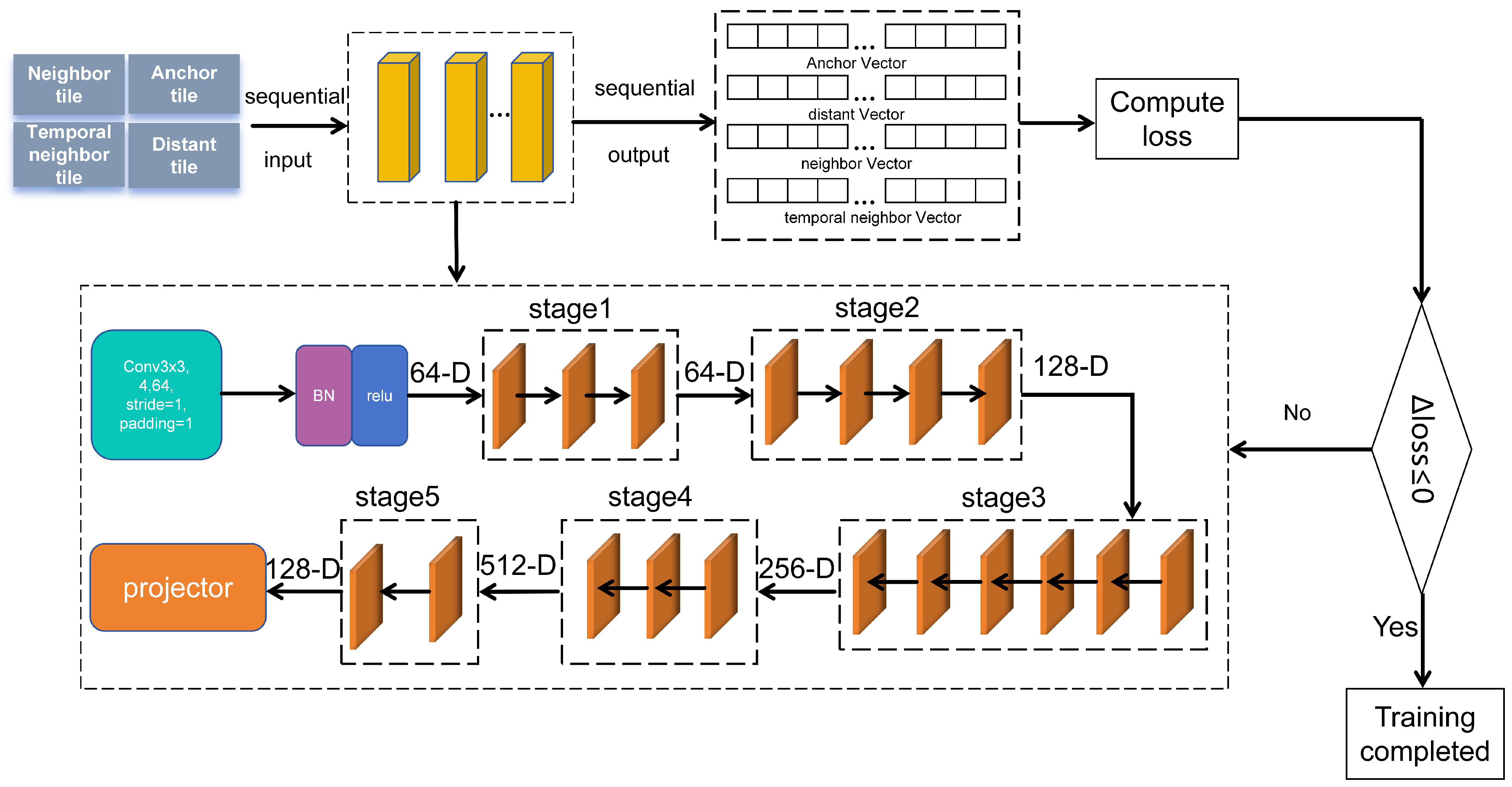
- We develop a contrastive self-supervised learning framework that generates deep meta-connectivity representations (DMCR) for multispectral tiles. The model is trained on groups of four tiles selected based on their meta-connectivity, encouraging it to learn meaningful spatial patterns. A random forest (RF) model then uses the DMCR vectors along with matched in situ measurements to estimate key water quality indicators such as chlorophyll-a and turbidity.
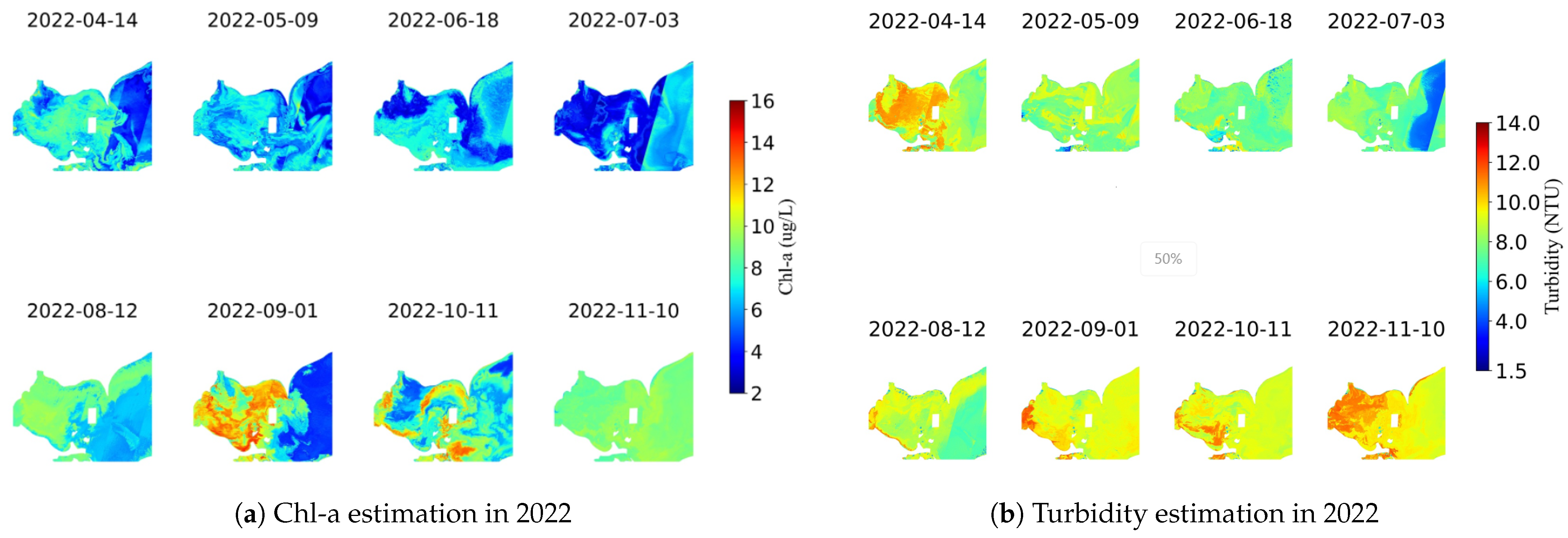
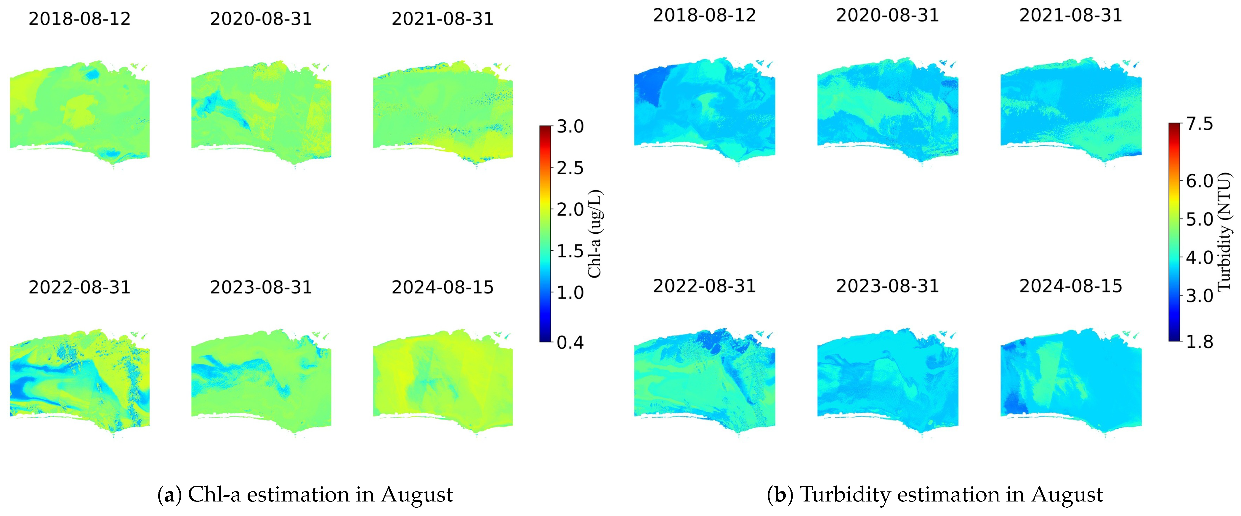
- We conduct comprehensive experiments to evaluate the performance of our approach. These include both quantitative assessments of estimation accuracy and qualitative analyses through visualization of chlorophyll-a and turbidity distributions across Lake Erie and Lake Ontario. Results confirm that DMCR offers a reliable and effective solution for monitoring optically-active water quality parameters.
2. Materials and Methods
2.1. Study Area
2.2. Data
2.2.1. In Situ Data
2.2.2. Satellite Data
- Temporal proximity—The in situ measurement collection date must be within ±5 days of the Sentinel-2 acquisition date.
- Spatial coverage—The monitoring station’s latitude and longitude must fall within the corresponding Sentinel-2 image’s geographic range.
- Cloud-free conditions at monitoring sites—Only images without cloud coverage at the field measurement locations are considered valid.
2.3. Meta-Connectivity of Water Quality Between Tiles
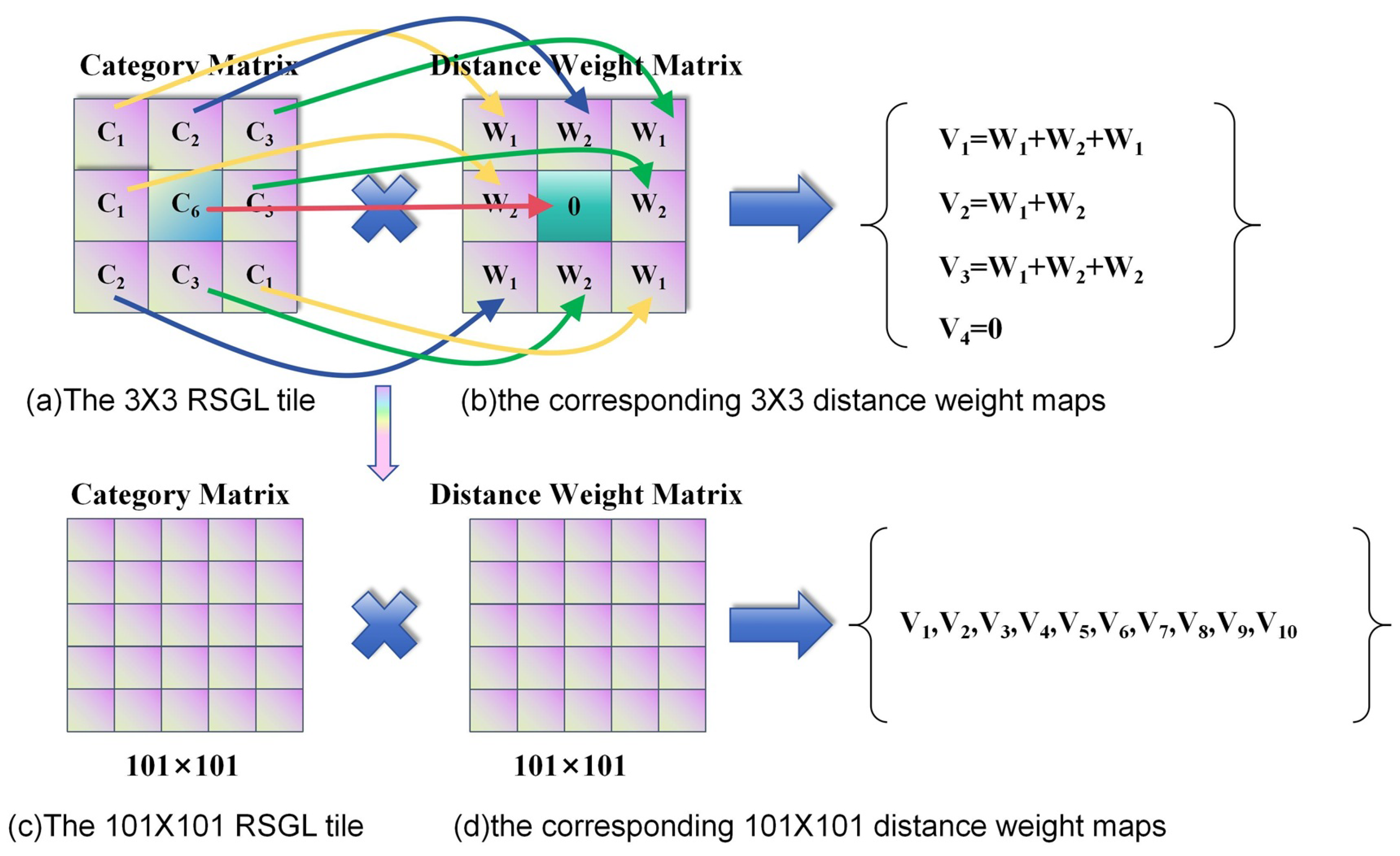
2.3.1. Generation of Meta-Feature Vectors for Connectivity Analysis
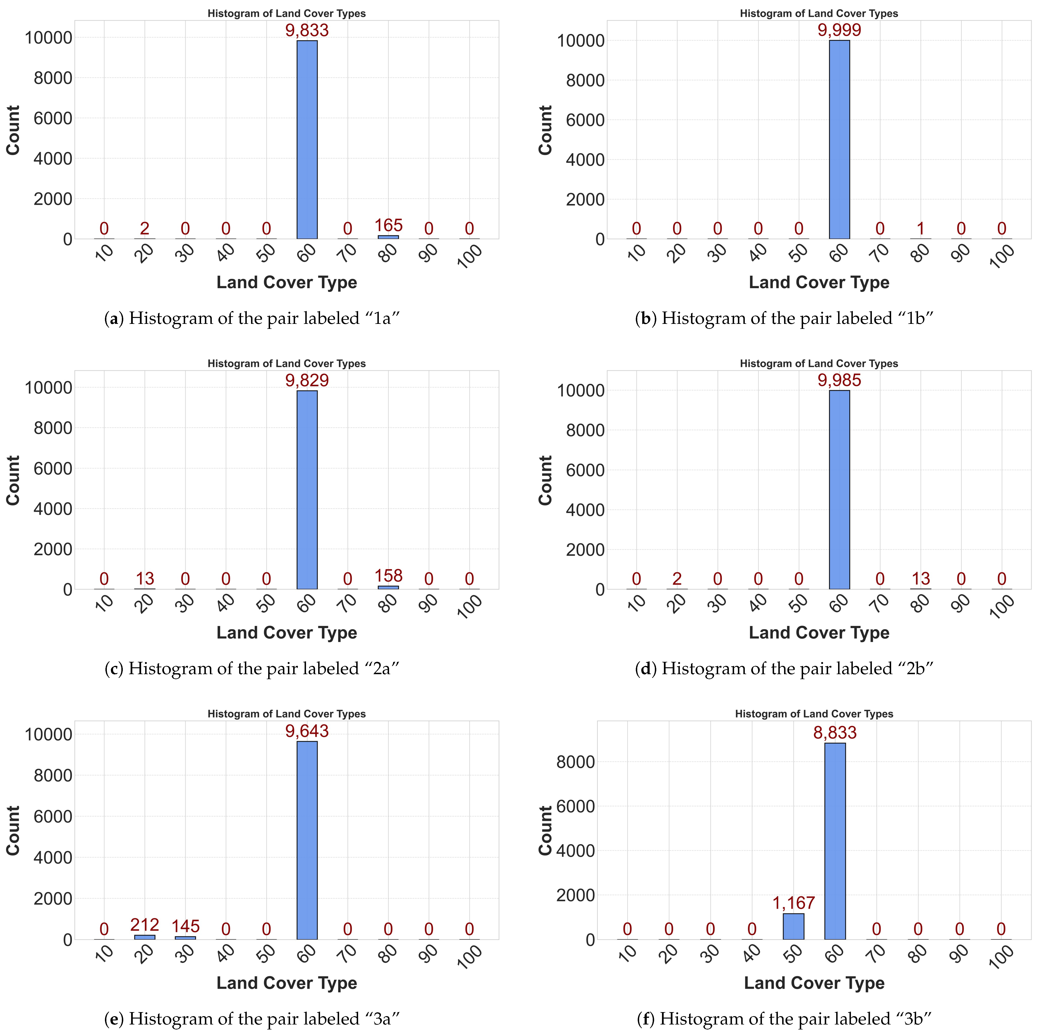
2.3.2. Effect of Water Quality Meta-Connectivity
2.4. Deep Meta-Connectivity Representation for Optically-Active Water Quality Parameters Estimation
2.4.1. Learning Deep Meta-Connectivity Representation Vectors for Tiles
2.4.2. Quadruple-Tiles Sampling
- Anchor Tile (): A point is randomly selected from the candidate pool. The MS tile centered at from the image is designated as the anchor tile. Its corresponding meta-feature vector is computed using the spatially aligned LC tile.
- Neighbor () or Distant () Tile: Another point is randomly selected from the remaining candidates. Its MS tile and meta-feature vector are generated. The Euclidean distance is then compared to our meta-connectivity threshold TH. If the distance is less than TH, the tile is labeled as a neighbor tile , forming a positive pair with the anchor based on similar land-cover context; otherwise, it is labeled as a distant tile , forming a negative pair. This process is repeated until both neighbor () and distant () tiles are selected.
- Temporal Neighbor Tile (): This tile is extracted from the second MS image (at ) at the exact same geographic coordinates as the anchor tile . It represents a positive sample in the temporal dimension, as it shares the same location and consequently the same meta-feature vector as the anchor, but captures potential subtle changes in water appearance over a short time.
2.4.3. Producing Deep Meta-Connectivity Representation with Neural Network
2.5. Optically-Active Water Quality Parameter Estimation with Deep Meta-Connectivity Representation
3. Results
3.1. Performance of DMCR
3.1.1. Selected Comparison Methods
3.1.2. Convergence Speed of the Loss Function During Training
3.2. Estimation of Optically-Active Water Quality Parameters
3.3. Temporal–Spatial Variation of Optically-Active Water Quality
3.3.1. Temporal–Spatial Variation of Optically-Active Water Quality in the West of Lake Erie
3.3.2. Temporal–Spatial Variation of Optically-Active Water Quality in the Middle of Lake Ontario
4. Discussion
4.1. A Novel Deep Representation for Water Quality Connectivity
4.2. Future Potential and Scalability of DMCR
4.3. Limitations of DMCR
5. Conclusions
Author Contributions
Funding
Data Availability Statement
Acknowledgments
Conflicts of Interest
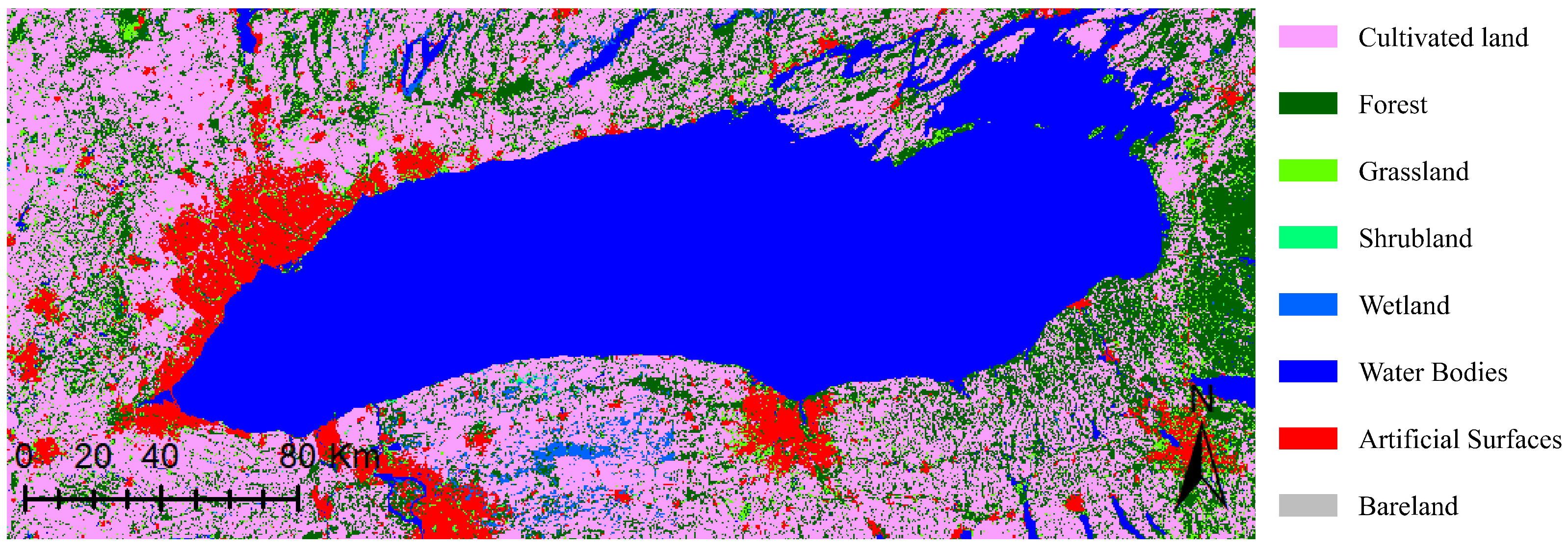
Appendix A. Land-Cover Types
| Land_Cover Type | Label Number |
|---|---|
| Cultivated Land | 10 |
| Forest | 20 |
| Grassland | 30 |
| Shrubland | 40 |
| Wetland | 50 |
| Water Bodies | 60 |
| Tundra | 70 |
| Artificial Surfaces | 80 |
| Bareland | 90 |
| Permanent Snow and Ice | 100 |
Appendix B. Algorithm A1
| Algorithm 1 Quadruple tiles sampling |
Input: Two multispectral (MS) images and one land cover (LC) image.
Output: Quadruple-tiles set
For Do Randomly select 1 point from the sampling points set. Around the center pixel , extract a tile from the MS image at (labeled ) and a corresponding tile from the LC image (labeled ) respectively. is also labeled as an anchor tile . Compute the meta-feature vector of TS1 as Formula (4) using corresponding . While not extract triplet vectors do Randomly select another 1 point except from the sampling points set. Around the center pixel , extract a tile from the MS image at (labeled ) and a tile from the LC image (labeled ) respectively. Compute the meta-feature vector of as Formula (4) using . If TH then is labeled as a neighbor tile . Else is labeled as a distant tile . EndIf EndWhile Remove the selected three points from the sampling points set. Extract a tile as the temporal neighbor tile from the MS image at . The spatial position and size of the tile are the same as that of . One quadruple-tiles vector T= is obtained. EndFor |
Appendix C. Flow of SimCLR
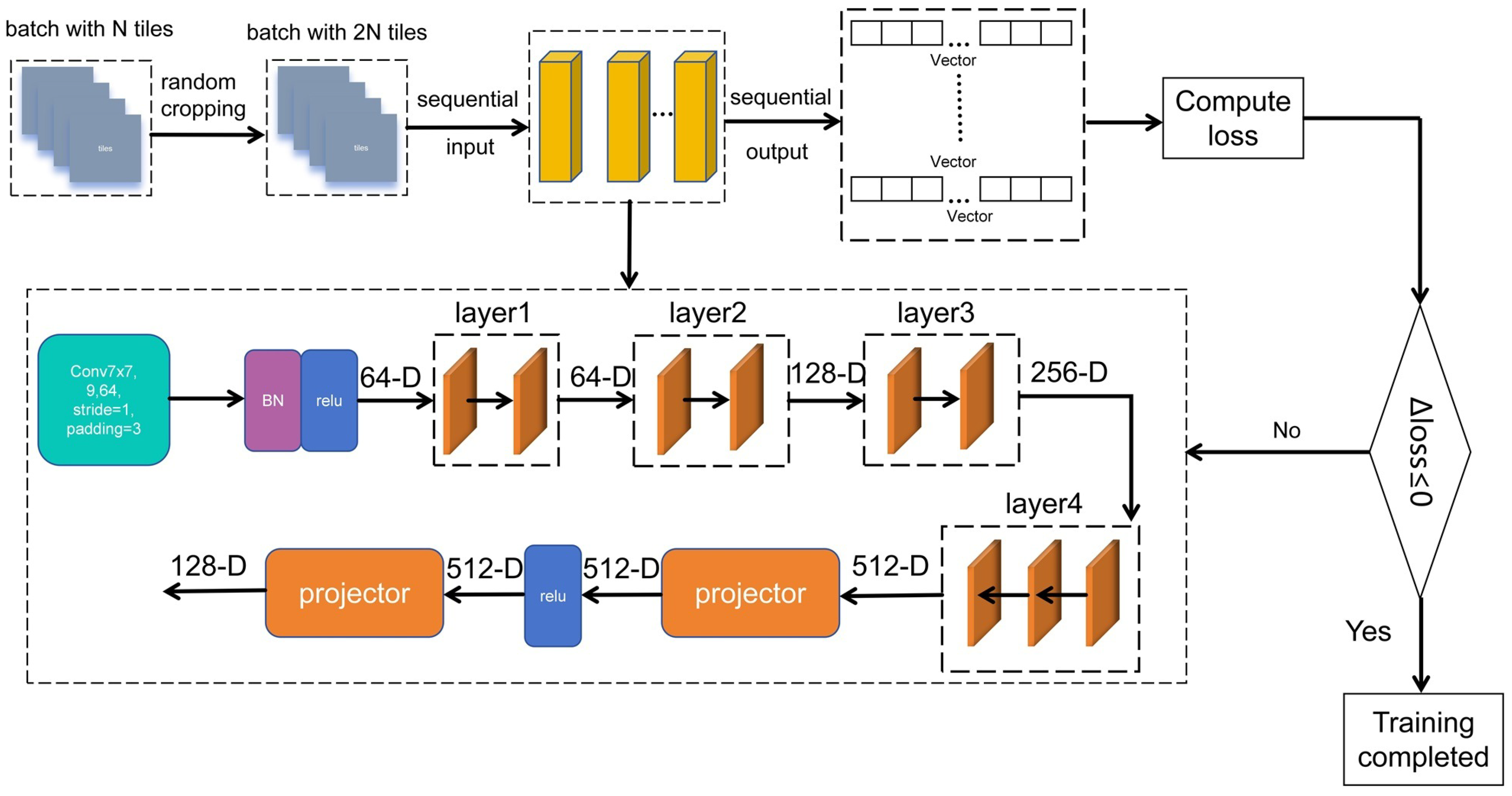
References
- Guo, H.; Zhu, X.; Huang, J.J.; Zhang, Z.; Tian, S.; Chen, Y. An enhanced deep learning approach to assessing inland lake water quality and its response to climate and anthropogenic factors. J. Hydrol. 2023, 620, 129466. [Google Scholar] [CrossRef]
- Zhu, W. Remote Sensing Statistical Inference for Colored Dissolved Organic Matter in Inland Water: Case Study in Qiandao Lake. IEEE J. Sel. Top. Appl. Earth Obs. Remote Sens. 2023, 16, 7462–7470. [Google Scholar] [CrossRef]
- Dong, L.; Gong, C.; Huai, H.; Wu, E.; Lu, Z.; Hu, Y.; Li, L.; Yang, Z. Retrieval of Water Quality Parameters in Dianshan Lake Based on Sentinel-2 MSI Imagery and Machine Learning: Algorithm Evaluation and Spatiotemporal Change Research. Remote Sens. 2023, 15, 5001. [Google Scholar] [CrossRef]
- Liu, B.; Li, T. A Machine-Learning-Based Framework for Retrieving Water Quality Parameters in Urban Rivers Using UAV Hyperspectral Images. Remote Sens. 2024, 16, 905. [Google Scholar] [CrossRef]
- Lu, Q.; Si, W.; Wei, L.; Li, Z.; Xia, Z.; Ye, S.; Xia, Y. Retrieval of Water Quality from UAV-Borne Hyperspectral Imagery: A Comparative Study of Machine Learning Algorithms. Remote Sens. 2021, 13, 3928. [Google Scholar] [CrossRef]
- Giardino, C.; Brando, V.E.; Dekker, A.G.; Strömbeck, N.; Candiani, G. Assessment of water quality in Lake Garda (Italy) using Hyperion. Remote Sens. Environ. 2007, 109, 183–195. [Google Scholar] [CrossRef]
- Zhou, X.; Chen, J.; Rakstad, T.E.; Ploughe, M.; Tang, P. Water Chlorophyll Estimation in an Urban Canal System With High-Resolution Remote Sensing Data. IEEE Geosci. Remote Sens. Lett. 2021, 18, 1876–1880. [Google Scholar] [CrossRef]
- Abd-Elrahman, A.; Croxton, M.; Pande-Chettri, R.; Toor, G.S.; Smith, S.; Hill, J. In situ estimation of water quality parameters in freshwater aquaculture ponds using hyperspectral imaging system. ISPRS J. Photogramm. Remote Sens. 2011, 66, 463–472. [Google Scholar] [CrossRef]
- Cao, L.; Zhang, D.; Guo, Q.; Zhan, J. Inversion of Water Quality Parameter Bod5 Based on Hyperspectral Remotely Sensed Data in Qinghai Lake. In Proceedings of the 2021 IEEE International Geoscience and Remote Sensing Symposium IGARSS, Brussels, Belgium, 11–16 July 2021; pp. 5036–5039. [Google Scholar]
- Xiong, J.; Lin, C.; Cao, Z.; Hu, M.; Xue, K.; Chen, X.; Ma, R. Development of remote sensing algorithm for total phosphorus concentration in eutrophic lakes: Conventional or machine learning? Water Res. 2022, 215, 118213. [Google Scholar] [CrossRef] [PubMed]
- He, J.; Chen, Y.; Wu, J.; Stow, D.A.; Christakos, G. Space-time chlorophyll-a retrieval in optically complex waters that accounts for remote sensing and modeling uncertainties and improves remote estimation accuracy. Water Res. 2020, 171, 115403. [Google Scholar] [CrossRef]
- Yang, C.; Tan, Z.; Li, Y.; Shen, M.; Duan, H. A comparative analysis of machine learning methods for algal Bloom detection using remote sensing images. IEEE J. Sel. Top. Appl. Earth Obs. Remote Sens. 2023, 16, 7953–7967. [Google Scholar] [CrossRef]
- Wang, J.; Ke, C.Q.; Cai, Y.; Ji, J.; Wang, Z. A novel convolutional neural network for the extraction of algal bloom and aquatic vegetation in typical eutrophic shallow lakes. IEEE J. Sel. Top. Appl. Earth Obs. Remote Sens. 2025, 18, 8099–8111. [Google Scholar] [CrossRef]
- Tang, Y.; Feng, Y.; Fung, S.; Xomchuk, V.R.; Jiang, M.; Moore, T.; Beckler, J. Spatiotemporal deep-learning-based algal bloom prediction for Lake Okeechobee using multisource data fusion. IEEE J. Sel. Top. Appl. Earth Obs. Remote Sens. 2022, 15, 8318–8331. [Google Scholar] [CrossRef]
- Aptoula, E.; Ariman, S. Chlorophyll-a Retrieval From Sentinel-2 Images Using Convolutional Neural Network Regression. IEEE Geosci. Remote Sens. Lett. 2022, 19, 1–5. [Google Scholar] [CrossRef]
- Taheri Dehkordi, A.; Hashemi, H.; Naghibi, A.; Mehran, A. Ensemble of Pruned Bagged Mixture Density Networks for Improved Water Quality Retrieval Using Sentinel-2 and Landsat-8 Remote Sensing Data. IEEE Geosci. Remote Sens. Lett. 2024, 21, 1–5. [Google Scholar] [CrossRef]
- Yang, H.; Kong, J.; Hu, H.; Du, Y.; Gao, M.; Chen, F. A review of remote sensing for water quality retrieval: Progress and challenges. Remote Sens. 2022, 14, 1770. [Google Scholar] [CrossRef]
- Ewuzie, U.; Bolade, O.P.; Egbedina, A.O. Application of deep learning and machine learning methods in water quality modeling and prediction: A review. In Current Trends and Advances in Computer-Aided Intelligent Environmental Data Engineering; Academic Press: Cambridge, MA, USA, 2022; pp. 185–218. [Google Scholar]
- Wai, K.P.; Chia, M.Y.; Koo, C.H.; Huang, Y.F.; Chong, W.C. Applications of deep learning in water quality management: A state-of-the-art review. J. Hydrol. 2022, 613, 128332. [Google Scholar] [CrossRef]
- Wu, R.; Wang, W.; Li, S. Soft measurement of ammonia nitrogen in sea cucumber aquaculture water via transfer learning. In Proceedings of the 2022 4th International Conference on Industrial Artificial Intelligence (IAI), Shenyang, China, 24–27 August 2022; pp. 1–5. [Google Scholar]
- Syariz, M.A.; Lin, C.H.; Heriza, D.; Lasminto, U.; Sukojo, B.M.; Jaelani, L.M. A transfer learning technique for inland chlorophyll-a concentration estimation using Sentinel-3 imagery. Appl. Sci. 2021, 12, 203. [Google Scholar] [CrossRef]
- Zhu, N.; Ji, X.; Tan, J.; Jiang, Y.; Guo, Y. Prediction of dissolved oxygen concentration in aquatic systems based on transfer learning. Comput. Electron. Agric. 2021, 180, 105888. [Google Scholar] [CrossRef]
- Tian, W.; Liao, Z.; Wang, X. Transfer learning for neural network model in chlorophyll-a dynamics prediction. Environ. Sci. Pollut. Res. 2019, 26, 29857–29871. [Google Scholar] [CrossRef]
- Lumini, A.; Nanni, L. Deep learning and transfer learning features for plankton classification. Ecol. Inform. 2019, 51, 33–43. [Google Scholar] [CrossRef]
- Li, H.; Li, Y.; Zhang, G.; Liu, R.; Huang, H.; Zhu, Q.; Tao, C. Global and local contrastive self-supervised learning for semantic segmentation of HR remote sensing images. IEEE Trans. Geosci. Remote Sens. 2022, 60, 1–14. [Google Scholar] [CrossRef]
- Zhi, W.; Appling, A.P.; Golden, H.E.; Podgorski, J.; Li, L. Deep learning for water quality. Nat. Water 2024, 2, 228–241. [Google Scholar] [CrossRef]
- Pu, F.; Ding, C.; Chao, Z.; Yu, Y.; Xu, X. Water-quality classification of inland lakes using Landsat8 images by convolutional neural networks. Remote Sens. 2019, 11, 1674. [Google Scholar] [CrossRef]
- GB3838-2002; Environmental Quality Standard for Surface Water. State Environmental Protection Administration: Beijing, China, 2002.
- Akhtar, N.; Syakir Ishak, M.I.; Bhawani, S.A.; Umar, K. Various natural and anthropogenic factors responsible for water quality degradation: A review. Water 2021, 13, 2660. [Google Scholar] [CrossRef]
- Anh, N.T.; Nhan, N.T.; Schmalz, B.; Le Luu, T. Influences of key factors on river water quality in urban and rural areas: A review. Case Stud. Chem. Environ. Eng. 2023, 8, 100424. [Google Scholar] [CrossRef]
- Zhang, S.; Liu, N.; Luo, M.; Jiang, T.; Chan, T.O.; Yau, C.S.T.; Sun, Y. Downscaling Sentinel-3 Chlorophyll-a Concentration for Inland Lakes Based on Multivariate Analysis and Gradient Boosting Decision Trees Regression. IEEE J. Sel. Top. Appl. Earth Obs. Remote Sens. 2023, 16, 7850–7865. [Google Scholar] [CrossRef]
- Uddin, M.G.; Nash, S.; Olbert, A.I. A review of water quality index models and their use for assessing surface water quality. Ecol. Indic. 2021, 122, 107218. [Google Scholar] [CrossRef]
- Robinson, R.M.; Robinson, R.M. Cross Border Governmental Organizations and Tragedies of the Commons. In Environmental Organizations and Reasoned Discourse; Palgrave Macmillan: Cham, Switzerland, 2021; pp. 273–297. [Google Scholar]
- Estepp, L.R.; Reavie, E.D. The ecological history of Lake Ontario according to phytoplankton. J. Great Lakes Res. 2015, 41, 669–687. [Google Scholar] [CrossRef]
- Jenny, J.P.; Anneville, O.; Arnaud, F.; Baulaz, Y.; Bouffard, D.; Domaizon, I.; Bocaniov, S.A.; Chèvre, N.; Dittrich, M.; Dorioz, J.M.; et al. Scientists’ warning to humanity: Rapid degradation of the world’s large lakes. J. Great Lakes Res. 2020, 46, 686–702. [Google Scholar] [CrossRef]
- Wang, H.; Convertino, M. Algal bloom ties: Systemic biogeochemical stress and Chlorophyll-a shift forecasting. Ecol. Indic. 2023, 154, 110760. [Google Scholar] [CrossRef]
- Louis, J.; Pflug, B.; Main-Knorn, M.; Debaecker, V.; Mueller-Wilm, U.; Iannone, R.Q.; Cadau, E.G.; Boccia, V.; Gascon, F. Sentinel-2 global surface reflectance level-2A product generated with Sen2Cor. In Proceedings of the IGARSS 2019–2019 IEEE International Geoscience and Remote Sensing Symposium, Yokohama, Japan, 28 July–2 August 2019; IEEE: Piscataway, NJ, USA, 2019; pp. 8522–8525. [Google Scholar]
- Coulibaly, N.; Sanogo, S.; BA, A. Evaluation of SENTINEL-2 products-based algorithms in estimating water pollutants of the River Niger in Bamako. Environ. Res. Commun. 2024, 6, 085004. [Google Scholar] [CrossRef]
- Zheng, H.; Liu, Y.; Wan, W.; Zhao, J.; Xie, G. Large-scale prediction of stream water quality using an interpretable deep learning approach. J. Environ. Manag. 2023, 331, 117309. [Google Scholar] [CrossRef] [PubMed]
- Wu, J.; Zeng, S.; Yang, L.; Ren, Y.; Xia, J. Spatiotemporal Characteristics of the Water Quality and Its Multiscale Relationship with Land Use in the Yangtze River Basin. Remote Sens. 2021, 13, 3309. [Google Scholar] [CrossRef]
- Jean, N.; Wang, S.; Samar, A.; Azzari, G.; Lobell, D.; Ermon, S. Tile2vec: Unsupervised representation learning for spatially distributed data. In Proceedings of the AAAI Conference on Artificial Intelligence, Honolulu, HI, USA, 27 January–1 February 2019; Volume 33, pp. 3967–3974. [Google Scholar]
- He, K.; Zhang, X.; Ren, S.; Sun, J. Deep residual learning for image recognition. In Proceedings of the IEEE Conference on Computer Vision and Pattern Recognition, Las Vegas, NV, USA, 27–30 June 2016; pp. 770–778. [Google Scholar]
- Schonlau, M.; Zou, R.Y. The random forest algorithm for statistical learning. Stata J. 2020, 20, 3–29. [Google Scholar] [CrossRef]
- Chen, T.; Kornblith, S.; Norouzi, M.; Hinton, G. A simple framework for contrastive learning of visual representations. In Proceedings of the International Conference on Machine Learning, Virtual, 13–18 July 2020; pp. 1597–1607. [Google Scholar]
- Idrees, M.; Ahmad, S.; Khan, M.W.; Dahri, Z.H.; Ahmad, K.; Azmat, M.; Rana, I.A. Estimation of water balance for anticipated land use in the potohar plateau of the indus basin using SWAT. Remote Sens. 2022, 14, 5421. [Google Scholar] [CrossRef]
- Shao, M.; Xie, X.; Li, J.; Ren, W.; Chao, E. Fine-resolution estimation for urban surface water pollution susceptibility with multi-modal earth observation data. Environ. Res. Lett. 2024, 19, 064026. [Google Scholar] [CrossRef]
- Shiferaw, N.; Habte, L.; Waleed, M. Land use dynamics and their impact on hydrology and water quality of a river catchment: A comprehensive analysis and future scenario. Environ. Sci. Pollut. Res. 2025, 32, 4124–4136. [Google Scholar] [CrossRef]
- Song, Y.; Li, X.; Feng, L.; Zhang, G. Spatio-temporal dynamics coupling between land use/cover change and water quality in Dongjiang lake watershed using satellite remote sensing. Land 2024, 13, 861. [Google Scholar] [CrossRef]
- Ni, X.; Parajuli, P.B.; Ouyang, Y.; Dash, P.; Siegert, C. Assessing land use change impact on stream discharge and stream water quality in an agricultural watershed. Catena 2021, 198, 105055. [Google Scholar] [CrossRef]






| Sentinel-2 Date | In Situ Measurement Date | Sentinel-2 Range (Lat/Lon) | In Situ Position |
|---|---|---|---|
| 16 April 2023 | 17 April 2023 | 43.257356–44.222825 | (43.84083, −78.03889) |
| −79.770508–−78.380656 | |||
| 28 April 2022 | 24 April 2022 | 43.2012110–44.2151810 | (43.43333, −77.71167) |
| −78.4968860–−77.1873690 | |||
| 13 April 2023 | 15 April 2022 | 43.2593360–44.2259640 | (43.58028, −77.2) |
| −77.5040720–−76.1113170 |
| Lake | Algorithm | Training Set | Test Set | ||
| RMSE | RMSE | ||||
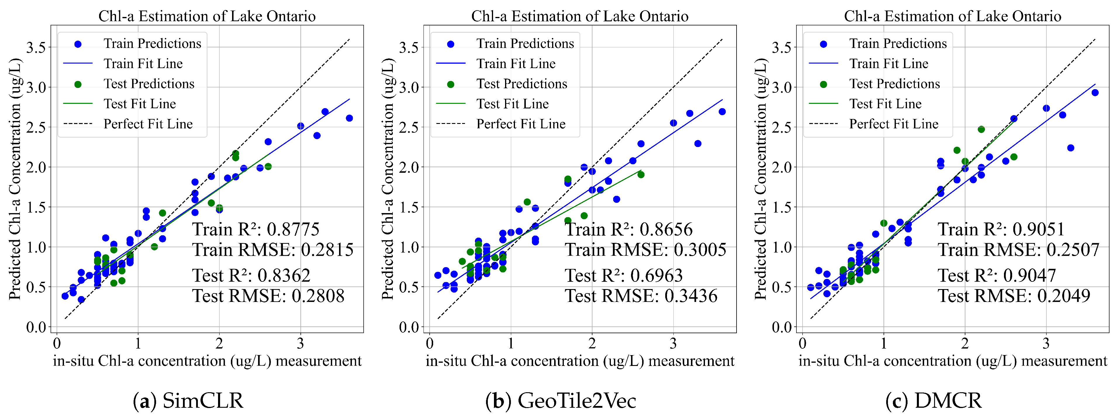
| Lake Ontario | SimCLR | 0.8775 | 0.2815 | 0.8362 | 0.2808 |
| GeoTile2Vec | 0.8656 | 0.3005 | 0.6963 | 0.3436 | |
| RF | 0.8414 | 1.1570 | 0.6386 | 1.1328 | |
| DMCR | 0.9051 | 0.2507 | 0.9047 | 0.2049 | |
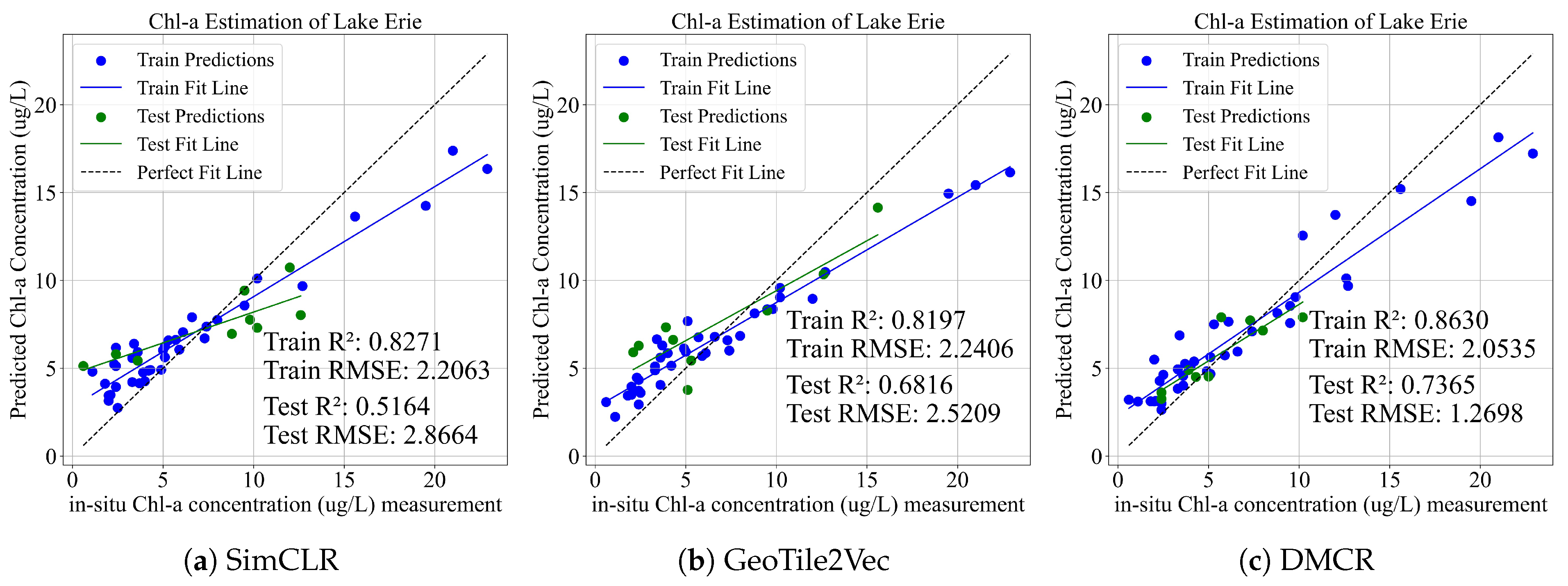
| Lake Erie | SimCLR | 0.8271 | 2.2063 | 0.5164 | 2.8664 |
| GeoTile2Vec | 0.8197 | 2.2406 | 0.6816 | 2.5209 | |
| RF | 0.8491 | 2.1843 | 0.7065 | 2.3511 | |
| DMCR | 0.8630 | 2.0535 | 0.7365 | 1.2698 | |
| Lake | Algorithm | Training Set | Test Set | ||
| RMSE | RMSE | ||||
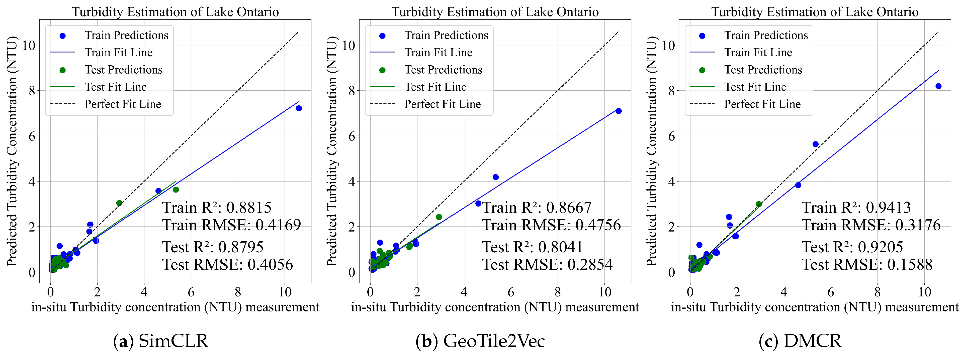
| Lake Ontario | SimCLR | 0.8815 | 0.4169 | 0.8795 | 0.4056 |
| GeoTile2Vec | 0.8667 | 0.4756 | 0.8041 | 0.2854 | |
| RF | 0.8962 | 0.4191 | 0.8424 | 0.2575 | |
| DMCR | 0.9413 | 0.3176 | 0.9205 | 0.1588 | |
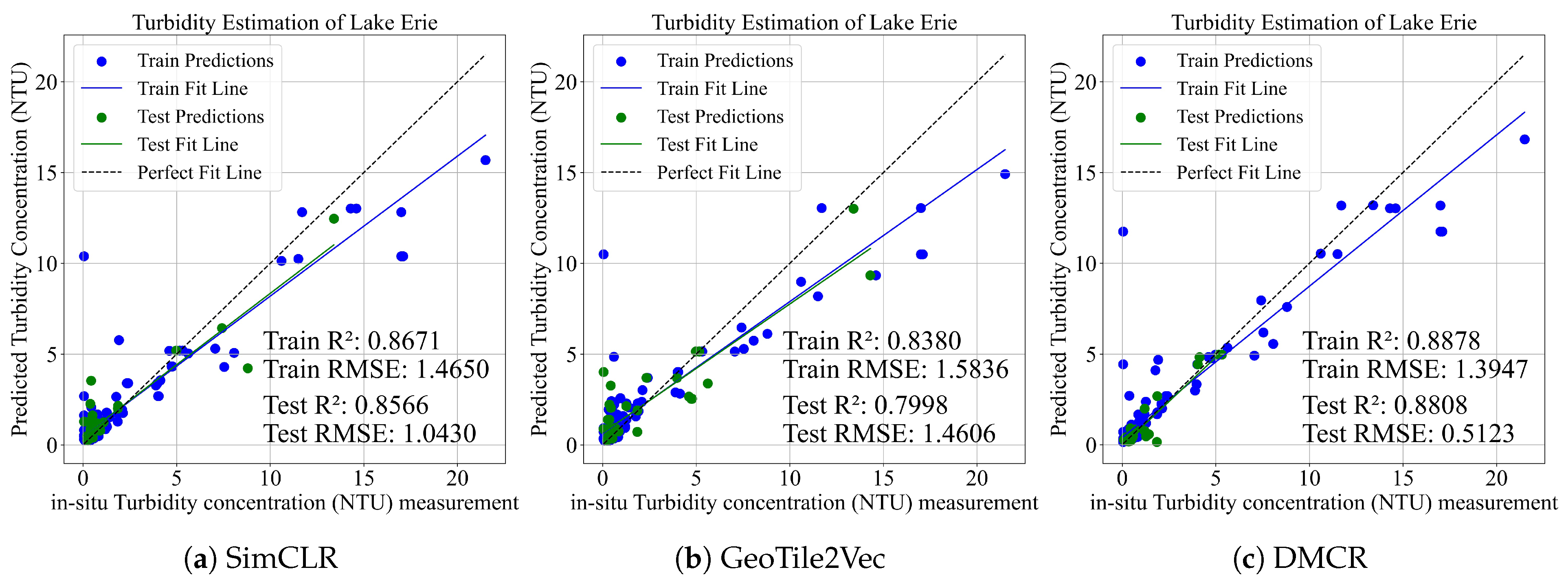
| Lake Erie | SimCLR | 0.8671 | 1.4650 | 0.8566 | 1.0430 |
| GeoTile2Vec | 0.8380 | 1.5836 | 0.7998 | 1.4606 | |
| RF | 0.8831 | 1.2422 | 0.7599 | 1.8772 | |
| DMCR | 0.8878 | 1.3947 | 0.8808 | 0.5123 | |
Disclaimer/Publisher’s Note: The statements, opinions and data contained in all publications are solely those of the individual author(s) and contributor(s) and not of MDPI and/or the editor(s). MDPI and/or the editor(s) disclaim responsibility for any injury to people or property resulting from any ideas, methods, instructions or products referred to in the content. |
© 2025 by the authors. Licensee MDPI, Basel, Switzerland. This article is an open access article distributed under the terms and conditions of the Creative Commons Attribution (CC BY) license (https://creativecommons.org/licenses/by/4.0/).
Share and Cite
Pu, F.; Luo, Z.; Yang, Y.; Chen, H.; Dai, Y.; Xu, X. Deep Meta-Connectivity Representation for Optically-Active Water Quality Parameters Estimation Through Remote Sensing. Remote Sens. 2025, 17, 2782. https://doi.org/10.3390/rs17162782
Pu F, Luo Z, Yang Y, Chen H, Dai Y, Xu X. Deep Meta-Connectivity Representation for Optically-Active Water Quality Parameters Estimation Through Remote Sensing. Remote Sensing. 2025; 17(16):2782. https://doi.org/10.3390/rs17162782
Chicago/Turabian StylePu, Fangling, Ziang Luo, Yiming Yang, Hongjia Chen, Yue Dai, and Xin Xu. 2025. "Deep Meta-Connectivity Representation for Optically-Active Water Quality Parameters Estimation Through Remote Sensing" Remote Sensing 17, no. 16: 2782. https://doi.org/10.3390/rs17162782
APA StylePu, F., Luo, Z., Yang, Y., Chen, H., Dai, Y., & Xu, X. (2025). Deep Meta-Connectivity Representation for Optically-Active Water Quality Parameters Estimation Through Remote Sensing. Remote Sensing, 17(16), 2782. https://doi.org/10.3390/rs17162782


