Article

Climate Warming-Driven Expansion and Retreat of Alpine Scree in the Third Pole over the Past 45 Years

1
State Key Laboratory for Regional and Urban Ecology, Research Center for Eco-Environmental Sciences, Chinese Academy of Sciences, Beijing 100085, China
2
Aerospace Information Research Institute, Chinese Academy of Sciences, Beijing 100094, China
*
Author to whom correspondence should be addressed.
Remote Sens. 2025, 17(15), 2611; https://doi.org/10.3390/rs17152611
Submission received: 16 May 2025 / Revised: 17 July 2025 / Accepted: 19 July 2025 / Published: 27 July 2025

Abstract

Alpine scree, a distinctive plateau ecosystem, serves as habitat for numerous rare and endangered species. However, current research does not differentiate it from desert in terms of spatial boundary, hindering biodiversity conservation and ecological monitoring efforts. Using the Tibetan Plateau as a case study, we defined the spatial boundary of alpine scree based on its surface formation process and examined its distribution and long-term evolution. The results show that in 2020, alpine scree on the Tibetan Plateau covered 73,735.34 km2, 1.5 times the area of glaciers. Alpine scree is mostly distributed at elevations between 4000 and 6000 m, with a slope of approximately 30–40 degrees. Characterized by low temperature and sparse rainfall, the regions are located in the humid zone. From 1975 to 2020, the area of alpine scree initially increased before declining, with an overall decrease of 560.68 km2. Climate warming was the primary driver of these changes, leading to an increase in scree from 1975 to 1995 and a decrease in scree from 1995 to 2020. Additionally, between 1975 and 2020, the Tibetan Plateau’s grasslands shifted upward by 16.47 km2. This study enhances our understanding of the spatial distribution and dynamics of this unique ecosystem, alpine scree, offering new insights into climate change impacts on alpine ecosystems.

1. Introduction

Alpine scree, a unique high-altitude ecosystem located below the snowline and above the treeline or grassline, is frequently found in high mountain or plateau regions globally [1]. Despite its barren appearance, alpine scree supports rich biodiversity, including cold-tolerant, wind-resistant, and radiation-resistant species, such as Rheum nobile, Meconopsis, Androsace tapete, and Arenaria kansuensis [1,2,3]. It also provides crucial habitats for endangered species like Panthera uncia and Pseudois nayaur [4]. Organisms here have adapted to extreme conditions, forming an ecosystem vital for biodiversity conservation [3,5]. The spatial distribution and dynamics of alpine scree are highly sensitive to climate fluctuations, making it a key indicator of high-altitude ecosystem responses to climate change [6,7]. However, data on the spatial boundary and extent of alpine scree are limited, and systematic analysis of their spatial pattern and long-term evolution is lacking. Within the context of global warming, the driving mechanisms behind the expansion and retreat of alpine scree—functioning as a “sentinel” for high-altitude ecosystems—remain unclear. This knowledge gap hampers efforts to enhance biodiversity conservation and improve early warning systems for high-altitude ecological security.
The Tibetan Plateau provides a clear example of alpine scree formation, driven by tectonic uplift, surface processes, and climatic factors. First, the ongoing collision and compression between the Indian and Eurasian plates has caused intense and complex uplift, creating a series of bedrock fault zones [8]. The activity of these fault zones leads to crustal rupture and deformation, forming mountain ranges and valleys [9]. This uplift is uneven, with variations in timing and rate across different regions, contributing to topographical undulations [10,11]. In addition, glacial erosion has deepened valleys, while glacial accumulation has formed moraines, further enhancing topographical variability [12]. Together, these processes create slopes exceeding 30 degrees, conducive to alpine scree formation. Second, since the Cenozoic, intense tectonic activities along the northern edge of the plateau, including plate collisions, strike-slip faulting, and crustal thickening, have led to mountain uplift and denudation [13,14]. These processes have caused rock erosion and fragmentation, producing large amounts of debris, which serve as the foundation for alpine scree. Third, in the periglacial zone (4000–6000 m), extreme diurnal temperature fluctuations (>20 °C) and intense radiation force thermal shock weathering, causing the bedrock to fracture into millimeter-scale cracks [15]. Under the influence of freeze–thaw weathering, the rocks fragment into small debris. These particles, transported by gravity and subsurface flow, accumulate on the slopes to form alpine scree (Figure 1). Alpine scree, composed of stones and gravel of varying sizes, is mostly gray and black with sparse vegetation, representing some of the most extreme plant habitats (Figure 1). The distribution and characteristics of this rock debris document topographical evolution, including mountain uplift timing and rates [16]. Thus, analyzing alpine scree spatial patterns yields critical insights into regional tectonic processes across temporal scales.
Remote sensing is a key technology for identifying land use/cover and delineating ecosystem boundaries at various scales, from local to global [17]. The integration of big data analysis, machine learning, and intelligent algorithms has enhanced the accuracy and spatiotemporal resolution of land use monitoring [18]. Sensors, such as Sentinel-2A and Sentinel-2B, provide extensive time-series data for land use detection [17]. Recently, multiple land use datasets with varying resolutions, including MODIS, ESA, Land Cover CCI, and LUH2 [19], have been developed, enabling comprehensive analysis of the earth’s surface at local to global scales [20,21]. However, these datasets often fail to accurately capture the extent and distribution of alpine scree, which is commonly misclassified as desert or barren land [22,23]. In the Tibetan Plateau, alpine scree is frequently mistaken for desert, with some studies reporting desert covering up to 1.07 million km2 [24]. However, alpine scree and desert differ significantly in structure, processes, and functions. Alpine scree is cold and moist, while desert is warmer and drier [25]. Therefore, accurately delineating the distribution of alpine scree using remote sensing data requires incorporating its unique formation mechanisms and characteristics.
Climate change alters temperature and precipitation patterns, significantly impacting scree dynamics. During the formation process of alpine scree, the downward movement of rock debris on steep slopes, driven by gravitational potential energy, is governed by two primary mechanisms: (1) matrix liquefaction due to seasonal freeze–thaw cycles (more than 200 freeze–thaw days annually), which lowers the friction between debris particles, and (2) slip channels formed by glacier retreat, which facilitate debris movement. The Tibetan Plateau, a sensitive amplifier of global climate change, has experienced notable warming in recent decades [26]. Research has found that the temperature on the Tibetan Plateau increased by approximately 0.44 °C per decade from 1979 to 2020—more than twice the global average of 0.19 °C per decade [27]. Warming increased from south to north and increased with altitude [28,29]. Therefore, climate warming can significantly affect the formation process of alpine scree. Additionally, global warming has led to substantial glacier retreat: between 2000 and 2018, the annual average glacier mass loss in the region was around 19–21 billion tons [30,31]. By 2050, the glacier area is projected to shrink by 22–35% compared to 2000, with mass loss ranging from 36% to 64% under different climate change scenarios [32]. Glacier melt creates favorable conditions for the expansion of alpine scree. Additionally, climate change is shifting ecosystem boundaries [33], with grassland vegetation on the Tibetan Plateau advancing to higher altitudes and latitudes [34]. Seed dispersal mechanisms influence the rate and direction of vegetation migration [35,36], thereby altering the distribution of grassland and alpine scree. Understanding these shifts is essential for developing ecological security strategies for the Tibetan Plateau.
This study proposes a method for mapping alpine scree based on its surface formation mechanism, identifies the spatial boundary and long-term evolutionary pattern of alpine scree on the Tibetan Plateau from 1975 to 2020, and explores how climate change influences scree expansion/retreat. This mapping approach fully utilizes existing remote sensing data products and can be applied to identify the spatial distribution of alpine scree in other high-altitude regions globally, offering a novel perspective on the impact of climate change on alpine ecosystems.

2. Materials and Methods
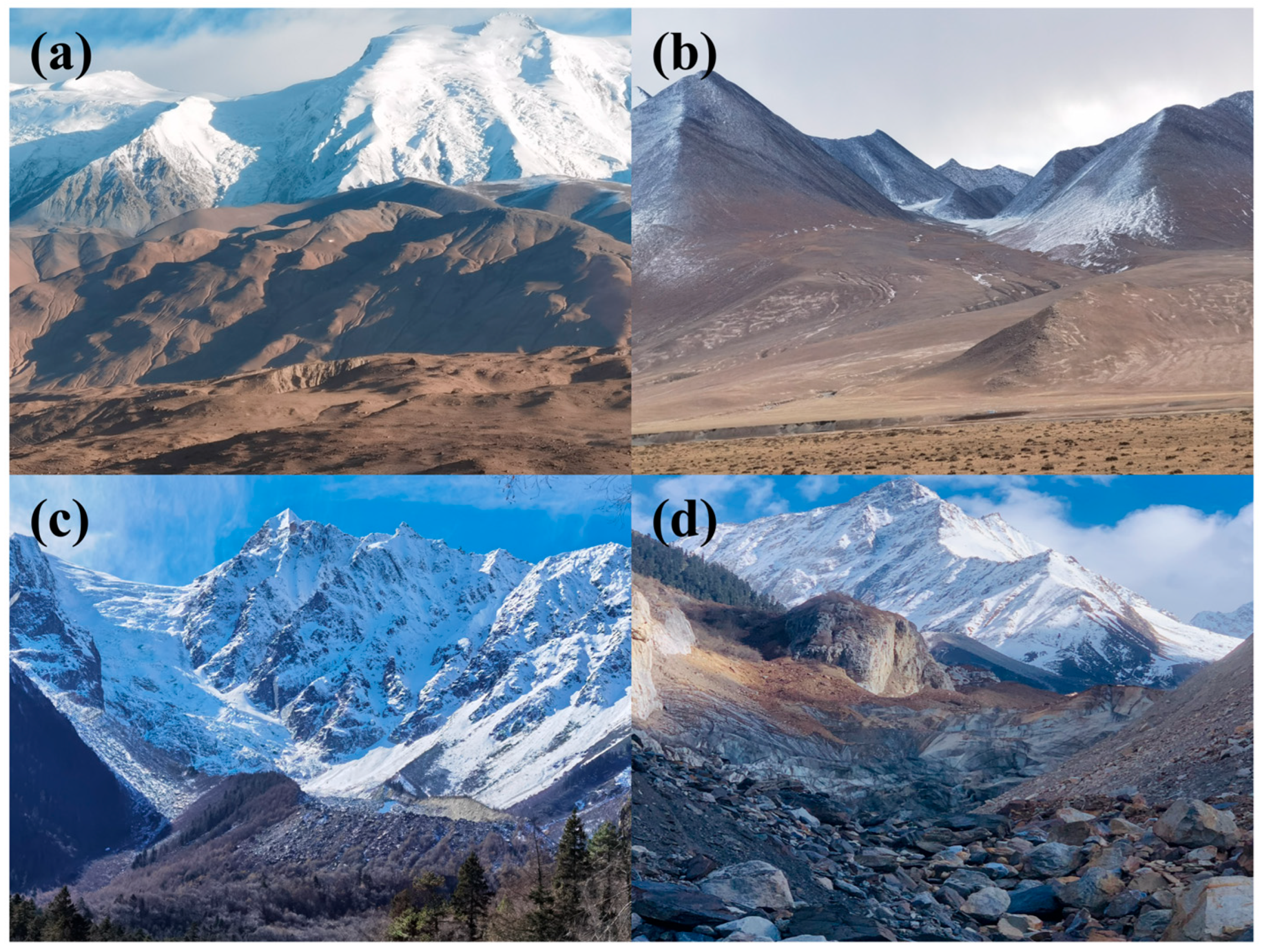
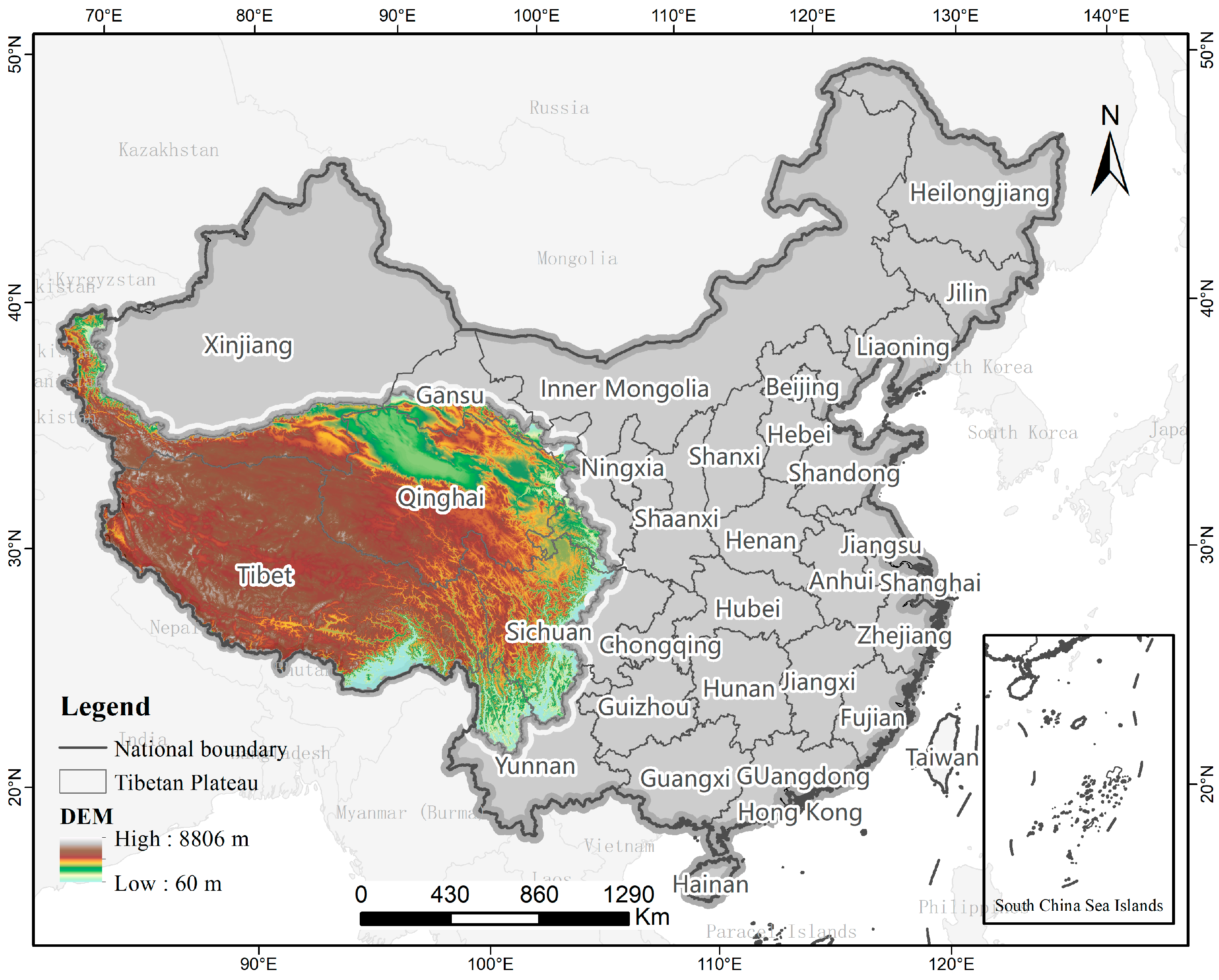
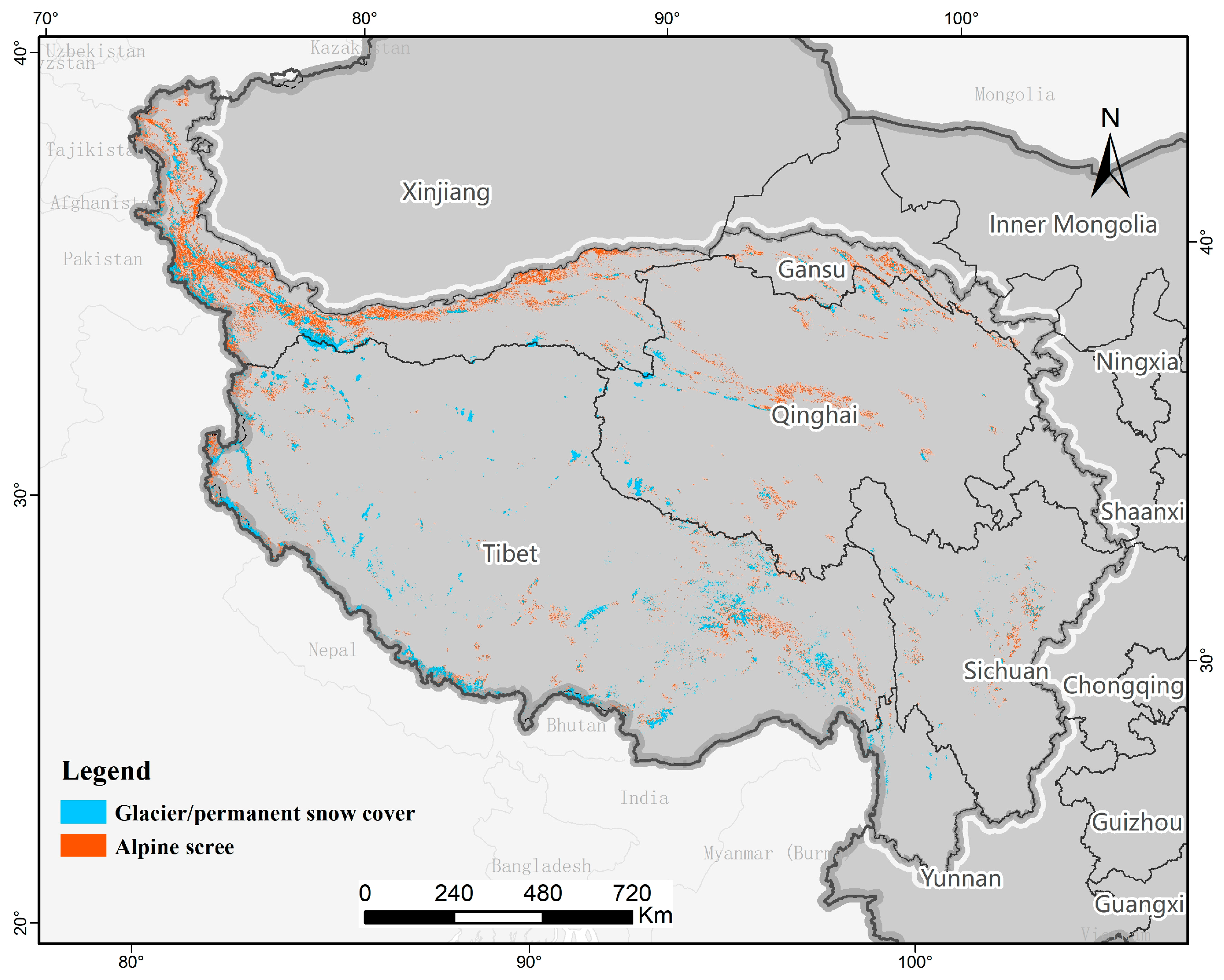
2.1. Study Areas

The Tibetan Plateau (Figure 2) is the world’s highest and largest plateau, with an average elevation exceeding 4000 m and covering approximately 2.79 million km2 [37,38]. Known as the “Third Pole”, its significant geological uplift and geography have shaped unique ecosystem patterns [33]. Since the Cenozoic, the ongoing collision between the Indian and Eurasian plates has created large-scale fault zones and mountain blocks along the plateau’s edges [13]. This forms a step-like topography with peaks, such as the Nyainqêntanglha and Gangdise mountains [11]. This topography, with faulted river valleys featuring vertical drops of 2000–3000 m and steep mountain slopes, provides an ideal condition for the formation of alpine scree. The distribution of alpine scree is influenced by factors, such as local lithology (e.g., variations in granite and limestone weathering rates), slope, and ice-margin processes [39]. The alpine scree in the study area, located in the ice-margin zone, consists of angular rock debris. Its profile exhibits a layered structure, with fine particles at the surface and coarser particles beneath. The vegetation cover is sparse, dominated by cushion plants (e.g., Androsace tapete) and cold-tolerant pioneer species (e.g., Saussurea medusa), forming a distinctive landscape embedded in rocky substrates [1,40]. Investigating the spatial distribution of alpine scree enhances our understanding of species survival strategies and niche differentiation in cold environments.
Studies have shown that global warming has led to a significant retreat of glaciers on the Tibetan Plateau [41]. This promotes the upward spread of alpine scree. From 2000 to 2018, the average annual loss of glacier reserves in the Tibetan Plateau and surrounding areas was about 19–21 billion tons [30,31]. The spatial boundary of alpine scree is closely tied to the snowline, making it highly sensitive to climate change. Consequently, studying on spatial distribution and dynamics of alpine scree provides insights into the impact of climate change on alpine ecosystems, offering scientific evidence for climate change mitigation and the conservation of high-altitude ecosystems.

2.2. Method of Mapping Alpine Scree

Surface formation process of alpine scree: In high-altitude regions, significant diurnal temperature fluctuations cause rocks to fracture and disintegrate through thermal expansion and contraction, producing fragments of varying sizes. These fragments gradually move downslope under the influence of gravity and glacial transport, accumulating in gentler areas to form fan-shaped scree slopes (Figure 3a,b). So, alpine scree exhibits three main characteristics: (1) the surface of alpine scree is primarily composed of stones and gravel with minimal or no vegetation cover, typically classified as bare rock or bare soil in remote sensing data products; (2) alpine scree is located adjacent to glaciers or perennial snow; and (3) alpine scree is formed by the slow movement of stones or gravel along the slope, resulting in a discernible gradient.
Mapping procedure of alpine scree: The mapping process begins by extracting bare rock and bare soil from land use data through the Extract by Attributes tool in ArcGIS 10.8. Alpine scree is then identified using the following criteria: (1) bare rock and bare soil adjacent to glaciers or perennial snow and (2) bare rock and bare soil with a slope exceeding a critical threshold. The regions of bare rock and bare soil, extracted based on the above conditions, are the distribution of alpine scree.
The land use datasets covering the whole of the Tibetan Plateau for the years 1975, 1990, 1995, 2000, 2005, 2010, 2015, and 2020 were downloaded from the National Tibetan Plateau Science Data Center (https://data.tpdc.ac.cn (accessed on 14 July 2023)) [42]. In land cover classification, bare rock refers to natural, hard rocky surfaces with vegetation coverage less than 0.04, while bare soil refers to natural, loose loamy surfaces with vegetation coverage less than 0.04. Object-oriented classification, change detection, and other methods were applied, integrating cloud computing, big data, and machine learning technologies, to obtain data with a spatial resolution of 30 m [42]. DEM (digital elevation model) data, on a 90 m grid, were obtained from the Data Centre for Resources and Environmental Sciences, Chinese Academy of Sciences (RESDC) (http://www.resdc.cn (accessed on 15 July 2023)). Slope data were derived from the DEM data through the Slope tool in ArcGIS 10.8.

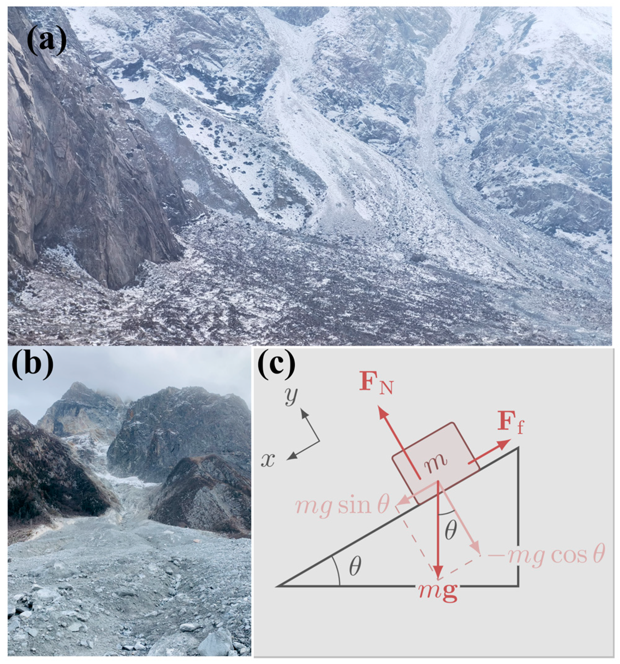
2.3. Determination of Critical Threshold of Slope (θ)

A theoretical framework (Figure 3c) for the critical conditions of block sliding on a slope was established based on the principle of static equilibrium in classical mechanics [43]. Assuming the block is a rigid, homogeneous cube and neglecting air resistance and groundwater pressure, the forces acting on the block are simplified as follows:
Gravitational Force (Fg): The direction of force is to act vertically downwards.
F g = m · g
where m is the block’s mass and g is the acceleration due to gravity.
Normal Reaction Force (N): The direction of force is perpendicular to the slope, balancing the normal component of the gravitational force.
N = F g · c o s θ
Maximum Static Friction Force (Ff): The direction of force is parallel to the slope, resisting sliding with a maximum value given by the following formula:
F f = μ · N
where μ is the friction coefficient between the block and the slope surface.
At the critical sliding point, the component of gravitational force along the slope equals the maximum static friction force:
F g · s i n θ = F f
Simplifying, we obtain the critical threshold of slope (θ):
θ = a r c t a n μ
This formula shows that the critical threshold of slope depends only on the static friction coefficient and is independent of the block’s mass. For rocks, the friction coefficient typically ranges from 0.4 to 0.6. Here, we chose μ = 0.5, and the critical threshold of slope was 26.6°. Thus, when the slope exceeds 26.6 degrees, the rock debris will begin to slide.

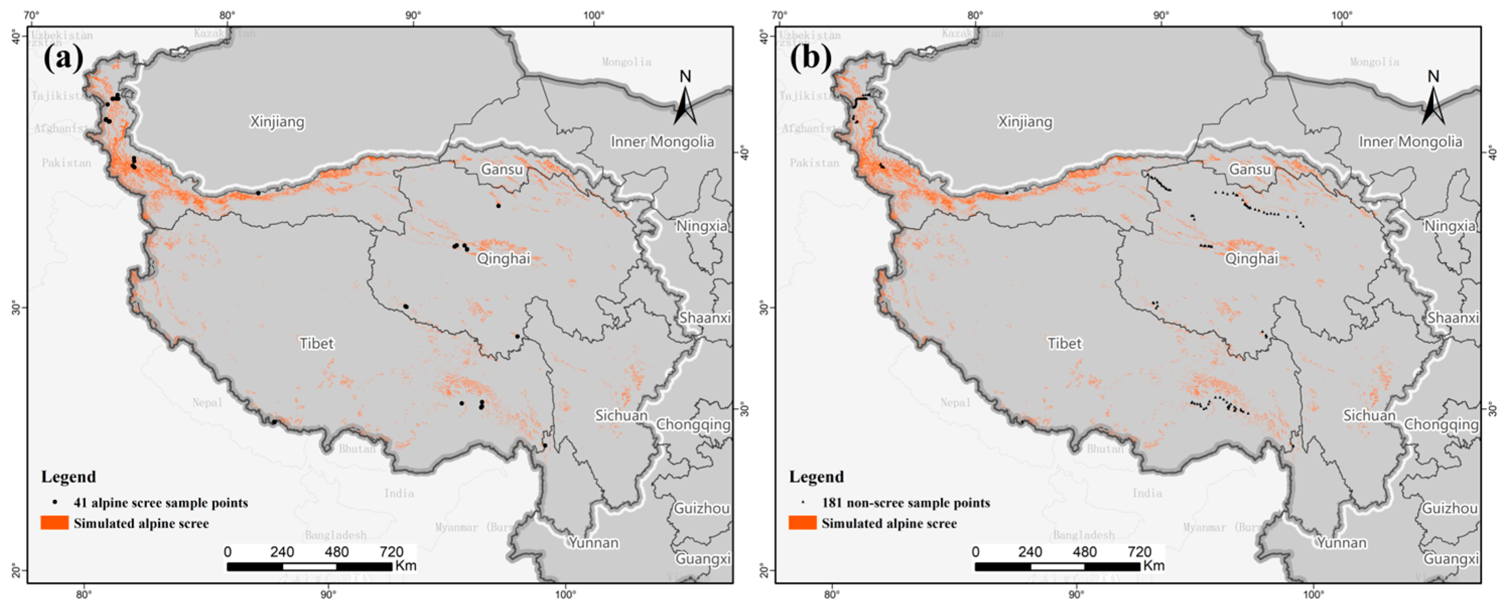
2.4. Field Investigation and Verification

To validate alpine scree simulation accuracy, we conducted field surveys using high-precision GPS in April 2023 and November 2024. Two types of sample points were designed within the study area: alpine scree sample points and non-scree sample points [44]. The non-scree points represent surrounding ecosystems, including glaciers, desert, and bare land. Bare rock and bare soil are strictly a remote sensing land cover class (unvegetated surface), whereas desert, bare land, and alpine scree are ecological designations applied based on context. In ecosystem classification, scree, desert, and bare land all consist of bare rock and bare soil. The key distinction is their proximity to glaciers and the critical threshold of slope: bare rock and bare soil in scree are adjacent to glaciers with a steep slope (typically >26.6°), while those in desert and bare land are not. Desert is located in arid regions, while bare land occurs in more humid areas. The selection of these sample points ensured a diverse and representative coverage of ecosystem types, enabling a thorough and accurate evaluation of the simulation results [44].

2.5. Statistical Analysis

First, the simulated alpine scree in 2020 was converted to point data using ArcGIS’s Raster to Point tool. The Multi-value Extraction to Points tool was then used to extract the corresponding variables, including elevation, slope, aridity index (AI), precipitation, temperature, and wind speed, in 2020. To illustrate the regional characteristics of alpine scree, kernel density estimation was performed using the ggplot2 package in R to visualize the probability density distribution of elevation, slope, AI, precipitation, temperature, and wind speed [45].
Second, the temporal changes in alpine scree were divided into two periods: 1975–1995 and 1995–2020. Land use transition matrices were constructed for each period to quantify the spatiotemporal dynamics of alpine scree [46].
Third, a binary logistic regression model was used to quantify the effects of climate change and topographic factors on the expansion and retreat of alpine scree in both periods (1975–1995 and 1995–2020) [47]. Areas of alpine scree expansion and retreat were converted to point data and assigned values of 1 and 0, respectively. The Extract Multi-Values to Points tool in ArcGIS 10.8 was used to extract corresponding variables, such as temperature change, precipitation change, AI change, DEM, and slope. The model was performed in SPSS 26, and stepwise-Wald was selected to identify significant variables.
The climate datasets used in the statistical analysis included temperature [48], precipitation [49], and AI [50] for the years 1975, 1995, and 2020, as well as wind speed for the year 2020. The climate datasets were downloaded from the National Tibetan Plateau Science Data Center (https://data.tpdc.ac.cn (accessed on 15 February 2024)), with a resolution of 1000 m.

3. Results

3.1. Ground-Truth Verification of Alpine Scree

To validate the accuracy of the alpine scree simulation, 222 sample points were investigated in field surveys (Figure 4), including 41 alpine scree sample points and 181 non-scree sample points. The confusion matrix (Table 1) shows that 39 of the 41 alpine scree points were accurate, and all 181 non-scree points were correctly classified. The simulation method achieved an accuracy of 99.10%, a precision of 100%, and a recall of 95.12%, confirming the feasibility of the alpine scree simulation approach.

3.2. Spatial Distribution and Characteristics of Alpine Scree

The area of alpine scree in 2020 was 73,735.34 km2, 1.5 times the size of the glacier area. The spatial distribution of alpine scree, shown in Figure 5, typically surrounds glaciers and is concentrated in the Kunlun, Nyainqêntanglha, and Qilian Mountains.
Alpine scree is predominantly found on high-altitude, steep slopes and in regions characterized by low temperatures, sparse rainfall, slight wind, and humidity. Most alpine scree occurs at altitudes between 4000 and 6000 m (Figure S1), with a smaller portion around 2000 m in the Pamir Plateau (e.g., Kashgar region, Xinjiang). Due to its surface formation process, most alpine scree areas have slopes ranging from 30° to 40°. The annual average temperature in these areas generally falls between −10 °C and 0 °C, with precipitation below 250 mm. The dryness index is low, and most alpine scree areas are found in humid regions. This is influenced by glacier meltwater, which distinguishes alpine scree from desert climates. Year-round wind speeds in alpine scree typically range from 3 to 5 m/s.

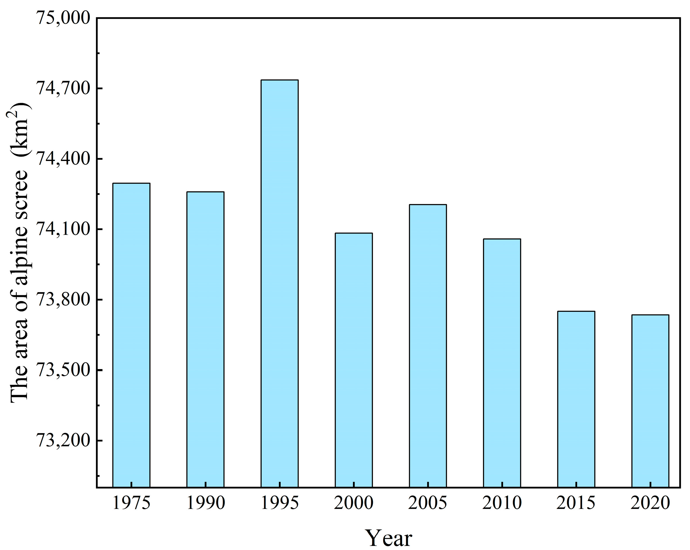
3.3. Trends in Alpine Scree Changes

The dynamics of alpine scree from 1975 to 2020 show an increasing trend followed by a decrease (Figure 6). This can be divided into two periods. The first period marks the growth phase of alpine scree from 1975 to 1995, with the area peaking at 74,735.61 km2 in 1995. The increase in alpine scree was primarily due to glacier melting. From 1975 to 1995, 1040.91 km2 of glacier area was converted into alpine scree (Table 2). This was driven by the upward shift in the snowline and rapid glacier retreat (Figure S2). However, the upward shift in the snowline also caused the local alpine scree to transition into desert (482.87 km2) and bare land (719.77 km2) (Table 2). As the snowline continued to rise, glaciers on some lower-altitude peaks completely melted. These areas were no longer adjacent to glaciers and transformed into desert or bare land. The climate in these regions also shifted with rising temperatures and increased dryness. The downward shift in the snowline led to the conversion of 302.28 km2 of alpine scree back into glaciers from 1975 to 1995. At the same time, local climate changes associated with the snowline prompted the conversion of 312.49 km2 of desert and 582.53 km2 of bare land into alpine scree (Table 2). Additionally, 12.95 km2 of grassland became alpine scree due to avalanches, which deposited debris over parts of the grassland. Vegetation also migrated upward, with forest and grassland shifting by 0.83 km2 and 3.50 km2, respectively (Table 2).
The second period marks the reduction phase of alpine scree from 1995 to 2020. By 2020, the area of alpine scree had decreased to 73,735.34 km2. Between 1995 and 2020, the area of glaciers declined slowly (Figure S2), with 489.78 km2 of glaciers transforming into alpine scree. During this period, 634.09 km2 of alpine scree changed into desert, and 619.97 km2 changed into bare land (Table 3). The downward shift in the snowline led to the reversion of 392.40 km2 of alpine scree to glaciers, while 98.59 km2 of desert and 80.22 km2 of bare land became alpine scree (Table 3). The upward migration of grassland was more pronounced in this period, with 12.97 km2 shifting upward (Table 3). Additionally, due to glacier meltwater and its erosive effects, 13.90 km2 of alpine scree transformed into wetland.
In terms of spatial distribution, the changes in alpine scree areas were primarily concentrated in the northern part of the Tibetan Plateau, particularly in Qinghai, where an increase of 1354.08 km2 was observed between 1975 and 1995 (Figure S3). Overall, scree areas decreased in Qinghai, Xinjiang, and Tibet from 1975 to 2020, while they increased in Gansu. Compared to arid regions, alpine scree areas exhibited greater changes in humid areas (Figure S4). The significant changes in alpine scree areas were concentrated in the area with an altitude of 4000–6000 m (Figure S5).

3.4. Impact of Climate Change on Alpine Scree

Climate change had a more significant impact on the expansion and retreat of alpine scree than elevation and slope (Table 4 and Table 5). In particular, climate warming primarily contributed to alpine scree dynamics. From 1975 to 1995, for every 1 °C increase in temperature, the probability of alpine scree expansion was 51,455.285 times greater than its retreat (Table 4). The temperature rise during this period triggered significant glacier area loss. However, from 1995 to 2020, for every 1 °C increase, the probability of alpine scree expansion was only 0.198 times that of its retreat (Table 5). As the snowline ascends, it alters the local water–heat environment. When glaciers disappear from peaks, bare rock and bare soil are classified as desert (in arid areas) or bare land (in humid areas), leading to a reduction in alpine scree. Between 1995 and 2020, 634.09 km2 of alpine scree transformed into desert, and 619.97 km2 transformed into bare land, resulting in a substantial loss of alpine scree area. Furthermore, warming drives vegetation migration, causing grassland and desert (i.e., desert shrub) to shift upward.
An increased aridity index leads to the expansion of alpine scree. On the one hand, higher aridity intensifies diurnal temperature fluctuations, enhancing thermal expansion and contraction, which promotes rock weathering. On the other hand, aridity fosters salt crystallization in rock pores, with the resulting pressure widening fractures and accelerating weathering. From 1975 to 1995, for each one-unit increase in the aridity index, the probability of alpine scree expansion was 4.522 times higher than its retreat (Table 4). However, from 1995 to 2020, this probability decreased to 1.344 times (Table 5). Thus, the impact of aridity weakened between 1995 and 2020. Additionally, increased precipitation also contributes to the expansion of alpine scree, likely due to rainwater erosion. Similar to the aridity index, the effect of precipitation on alpine scree expansion diminished from 1995 to 2020 compared to the earlier period (Table 4 and Table 5).

4. Discussion

Alpine scree is a unique ecosystem, prevalent in high-mountain glacial regions, and serves as habitat for cherished endangered and endemic species [51]. Investigating the distribution and long-term evolutionary patterns of alpine scree not only deepens our understanding of high-altitude ecosystems’ responses to climate change but also provides valuable insights into tectonic uplift processes [6,16]. This study introduces a method for identifying alpine scree boundaries, which was used to determine that the area of alpine scree on the Tibetan Plateau was 73,735.34 km2 in 2020. Previously, these regions were often misclassified as deserts, obscuring their ecological significance. To validate this method, we conducted field surveys and validation, achieving an accuracy of 99.10%. The successful application of this method offers strong support for ecological research on the Tibetan Plateau and provides a framework for identifying alpine scree in other high-altitude regions worldwide.
Alpine scree on the Tibetan Plateau ranges in elevation from 1750 to 8041 m, with the majority located between 4000 and 6000 m. Previous studies also suggest that some peculiar plants on alpine scree predominantly occur above 4000 m, forming the alpine glacial vegetation zone [1]. For instance, Tacheng is found at elevations between 4000 and 5000 m in the Xizang Himalayan foothills and northwest Yunnan [52]. Low-altitude alpine scree is mainly concentrated in the Pamir Plateau. Our field survey recorded a minimum elevation of 2060 m in Kashgar, Xinjiang. Most alpine scree areas experience temperatures ranging from −10 to 0 °C, creating harsh conditions for vegetation. Precipitation generally falls below 250 mm, but the low aridity index classifies most alpine scree as humid. This is primarily due to glacier meltwater. Some studies have highlighted that subglacial flow beneath these alpine scree areas is a crucial water source for plateau rivers, though the water retention capacity of alpine scree has often been overlooked [53].
Climate change drives boundary shifts in alpine scree [33], with global warming being the primary factor influencing its expansion and retreat. Our results indicate that warming contributed to the increase in alpine scree from 1975 to 1995, followed by a decrease from 1995 to 2020. Initially, warming causes the snowline to shift upward, expanding alpine scree. Research has found that glaciers in high-altitude mountains, such as the Alps, Andes, or Rockies, around the world have melted on a large scale, exposing bedrock and expanding alpine scree [54,55]. However, as warming continues, the complete melting of snow on some lower altitude peaks reduces the proximity of bare rock and bare soil to glaciers. This transforms these areas into arid deserts or moist bare land, thus reducing the extent of alpine scree. Predictive studies indicate that compared to 1961–1990, the average temperature for 2021–2050 and 2051–2100 will increase by 3.2–3.5 °C and 3.9–6.9 °C, respectively [56]. Future temperature on the Tibetan Plateau will continue to warm, which may lead to a decrease in alpine scree. Increased aridity accelerates rock weathering, furthering the expansion of alpine scree. When the aridity index increases, diurnal temperature fluctuations will increase, which intensifies thermal expansion and contraction. Additionally, higher aridity fosters salt mineral crystallization, further widening rock fractures. Together, aridity promotes the expansion of alpine scree by increasing rock debris. Higher precipitation enhances alpine scree expansion by reducing friction between rock debris, facilitating their movement and erosion. Compared to 1961–1990, the overall annual precipitation on the Tibetan Plateau for 2021–2050 and 2051–2100 increased by 10.4–11.0% and 14.2–21.4%, respectively [56]. However, heavy rainfall or glacier meltwater can also lead to alpine scree reduction (Figure 7a). From 1975 to 2020, 14.55 km2 of alpine scree transformed into wetlands. Natural events, like avalanches, also expand alpine scree, with 0.04 km2 of the forested area being covered by alpine scree (Figure 7b). Climate change has also led to the migration of grasslands to higher altitudes, with an upward shift of 16.47 km2 from 1975 to 2020 (Figure 7c). Increasing empirical studies have also found that vegetation on high-altitude mountains (i.e., the Alps and the Tibetan Plateau) is expanding towards high-altitude or high-latitude regions under climate warming [57,58].
Overall, the area of alpine scree decreased by 560.68 km2 between 1975 and 2020. With ongoing climate warming, the Tibetan Plateau’s alpine scree faces further reduction, posing several ecological risks. First, alpine scree provides critical habitats for endemic plant species, such as Tacheng, Saussurea, Androsace delavayi, and Rhodiola coccinea var. scabrida, which have adapted to extreme environments through traits like dwarfism, dense hair coverings, and rapid growth [40,59,60]. Reductions in the alpine scree area could lead to habitat compression, risking population decline or local extinction of these species [61]. Second, the loss of bare rock and permafrost reduces ecosystem resilience to disturbances, heightening the likelihood of natural disasters [62]. Third, the loss of alpine scree would disrupt ecological functions. Although the biomass of alpine scree plants is low, their root systems and microbial activity play a crucial role in soil carbon sequestration [63]. Habitat degradation could diminish carbon storage, exacerbating regional carbon imbalances. Additionally, subsurface flow beneath alpine scree is a vital water source for plateau rivers, which would impact downstream water resources [53,64]. To mitigate these risks, it is crucial to strengthen dynamic monitoring and risk assessment capabilities, informed by the distribution and dynamics of alpine scree. Protection areas should be established based on ecological risk levels, with human activities (e.g., tourism, mining) restricted in highly sensitive regions. Habitat restoration efforts, such as transplanting cushion plants to stabilize scree substrates, should also be carried out in targeted areas.
Several limitations exist in this study. First, the friction coefficient between rock fragments typically ranges from 0.4 to 0.6. Harsh climatic conditions in alpine scree may weather rock surfaces, potentially decreasing this coefficient. The friction coefficient is also influenced by factors such as rock material, contact area, and temperature [65]. Second, the simulation of alpine scree primarily focuses on surface formation processes under static assumptions (e.g., threshold slope angle). Real-world factors, such as freeze–thaw cycles, precipitation, sediment cohesion, wind speed, and glacial meltwater, are dynamic and spatially heterogeneous. These factors may accelerate the formation of alpine scree and even push it to flatter slopes. This leads to a decrease in the critical threshold of slope, thereby increasing the uncertainty in the scree simulation. Third, extreme climate events, such as changes in freeze–thaw cycle frequency, may exacerbate freeze-thaw erosion, affecting alpine scree stability. Fourth, although scree exhibits minimal interannual variation (with a change rate of −0.76% during 1975–2020), temporal mismatches between simulated data and field surveys may introduce some uncertainty. Future verification could employ real-time high-precision remote sensing data to validate these findings. Finally, alpine scree, historically classified as desert, has been underappreciated for its ecological functions. Future research should explore its ecological roles and contributions to high-altitude ecosystem succession [66,67].

5. Conclusions

This study presents a method for identifying the spatial boundary of alpine scree and applies it to the Tibetan Plateau. Field survey calibration achieved 99.10% accuracy. The area of alpine scree on the Tibetan Plateau was 73,735.34 km2 in 2020, 1.5 times the size of glaciers, accounting for approximately 2.65% of the total Tibetan Plateau. Alpine scree is primarily distributed in the Kunlun, Nyainqêntanglha, and Qilian Mountains, mainly at altitudes of 4000–6000 m, slopes of 30–40°, wind speeds of 3–5 m/s, temperatures between −10 °C and 0 °C, and precipitation below 250 mm, within a humid zone. From 1975 to 2020, the alpine scree initially increased before declining, with an overall decrease of 560.68 km2. Climate change had a greater impact on the expansion and retreat of alpine scree than DEM and slope factors. Climate warming was the primary driver of alpine scree dynamics, contributing to an increase in alpine scree from 1975 to 1995, followed by a decrease from 1995 to 2020. The increased aridity index and precipitation both promoted alpine scree expansion, with their impact being weaker in 1995–2020 than in 1975–1995. Between 1975 and 2020, the grassland on the Tibetan Plateau shifted upward by 16.47 km2. Continued global warming poses several ecological risks of further alpine scree reduction, potentially threatening the region’s rare, endangered, and endemic species. Future biodiversity conservation and ecological security efforts should account for the spatial distribution of alpine scree and its response to climate change.

Supplementary Materials

The following supporting information can be downloaded at https://www.mdpi.com/article/10.3390/rs17152611/s1, Figure S1: Characteristics of alpine screes in 2020: (a) DEM; (b) slope; (c) AI; (d)temperature, (e) precipitation; (f) wind vacuity; Figure S2: Change of glacier area from 1975 to 2020; Figure S3: Change of alpine screes in different provinces from 1975 to 2020; Figure S4: Change of alpine screes in different climate zone from 1975 to 2020; Figure S5: Change of alpine screes in different elevation from 1975 to 2020.

Author Contributions

Conceptualization, G.Z., B.W., L.Y., L.Z. (Lu Zhang) and Z.O.; methodology, G.Z. and L.Y.; software, G.Z., L.Y. and Y.Z.; validation, G.Z., Y.Z. and L.Z. (Liang Zhu); formal analysis, G.Z., Y.Z. and L.Z. (Li Zhang); investigation, G.Z., Y.Z., L.Z. (Li Zhang) and M.C.; resources, B.W. and L.Z. (Liang Zhu); data curation, G.Z., Y.Z., L.Z. (Li Zhang) and M.C.; writing—original draft preparation, G.Z.; writing—review and editing, Z.O.; visualization, G.Z., Y.Z., L.Z. (Lu Zhang) and M.C.; supervision, L.Z. (Li Zhang), B.W. and Z.O.; project administration, Z.O.; funding acquisition, Z.O. All authors have read and agreed to the published version of the manuscript.

Funding

This study was fully funded by the Second Tibetan Plateau Scientific Expedition and Research Program of China (Grant No.2019QZKK0308).

Data Availability Statement

The original contributions presented in the study are included in the article/Supplementary Material; further inquiries can be directed to the corresponding author.

Acknowledgments

The authors would like to thank the three anonymous reviewers for their suggestive comments that helped to improve the quality of the manuscript.

Conflicts of Interest

The authors declare that there are no conflicts of interest. We declare that we do not have any commercial or associative interest that represents a conflict of interest in connection with the work submitted.

References

  1. Yang, P.; Shu, X.; Chen, J.; Ni, M.; Wang, X.; Ti, B.; Jiang, C. Investigation on Plant Resources of Alpine Screes in Baimaxueshan National Nature Reserve. For. Surv. Plan. 2021, 46, 140–143. [Google Scholar]
  2. Gaur, U.N.; Raturi, G.P.; Bhatt, A.B. Quantitative response of vegetation in glacial moraine of central Himalaya. Environmentalist 2003, 23, 237–247. [Google Scholar] [CrossRef]
  3. Grabherr, G.; Gottfried, M.; Pauli, H. Climate Change Impacts in Alpine Environments. Geogr. Compass 2010, 4, 1133–1153. [Google Scholar] [CrossRef]
  4. Chen, X.; Zhao, L.; Hu, X.; Liu, M.; Luo, C.; Jiang, S.; Gu, X.; Guan, T. The seasonal activity patterns of bharal (Pseudois nayaur) in forest-meadow mosaic habitat. Chin. J. Zool. 2020, 55, 692–701. [Google Scholar]
  5. Vanneste, T.; Michelsen, O.; Graae, B.J.; Kyrkjeeide, M.O.; Holien, H.; Hassel, K.; Lindmo, S.; Kapás, R.E.; De Frenne, P. Impact of climate change on alpine vegetation of mountain summits in Norway. Ecol. Res. 2017, 32, 579–593. [Google Scholar] [CrossRef]
  6. Wang, G.; Bai, W.; Li, N.; Hu, H. Climate changes and its impact on tundra ecosystem in Qinghai-Tibet Plateau, China. Clim. Change 2010, 106, 463–482. [Google Scholar] [CrossRef]
  7. Choler, P.; Bayle, A.; Fort, N.; Gascoin, S. Waning snowfields have transformed into hotspots of greening within the alpine zone. Nat. Clim. Change 2024, 15, 80–85. [Google Scholar] [CrossRef]
  8. Xie, Y.; Balazs, A.; Gerya, T.; Xiong, X. Uplift of the Tibetan Plateau driven by mantle delamination from the overriding plate. Nat. Geosci. 2024, 17, 683–688. [Google Scholar] [CrossRef]
  9. Willett, S.D. How do mountains grow? Nat. Rev. Earth Environ. 2025, 6, 6. [Google Scholar] [CrossRef]
  10. Li, G.K.; Moon, S. Topographic stress control on bedrock landslide size. Nat. Geosci. 2021, 14, 307–313. [Google Scholar] [CrossRef]
  11. Braun, J.; Simon-Labric, T.; Murray, K.E.; Reiners, P.W. Topographic relief driven by variations in surface rock density. Nat. Geosci. 2014, 7, 534–540. [Google Scholar] [CrossRef]
  12. Egholm, D.L.; Nielsen, S.B.; Pedersen, V.K.; Lesemann, J.E. Glacial effects limiting mountain height. Nature 2009, 460, 884–887. [Google Scholar] [CrossRef]
  13. Hou, Z.; Liu, L.; Zhang, H.; Xu, B.; Wang, Q.; Yang, T.; Wang, R.; Zheng, Y.; Li, Y.; Gao, L.; et al. Cenozoic eastward growth of the Tibetan Plateau controlled by tearing of the Indian slab. Nat. Geosci. 2024, 17, 255–263. [Google Scholar] [CrossRef]
  14. Cui, L.; Yang, Y.; Xu, S.; Zhao, Z.; Mao, H.; Zhang, X.; Tu, C.; Zhang, Z.; Liu, W.; Liu, C. Denudation rates of granitic regolith along climatic gradient in Eastern China. Geomorphology 2021, 390, 107872. [Google Scholar] [CrossRef]
  15. Hao, D.; Bisht, G.; Gu, Y.; Leung, L.R. Regional and Teleconnected Impacts of Solar Radiation-Topography Interaction over the Tibetan Plateau. Geophys. Res. Lett. 2023, 50, e2023GL106293. [Google Scholar] [CrossRef]
  16. Zhang, Y.; Li, H. Late Cenozoic tectonic events in east Tibetan Plateau and extrusion-related orogenic system. Geology China 2016, 43, 1829–1852. [Google Scholar] [CrossRef]
  17. Xu, L.; Herold, M.; Tsendbazar, N.-E.; Masiliūnas, D.; Li, L.; Lesiv, M.; Fritz, S.; Verbesselt, J. Time series analysis for global land cover change monitoring: A comparison across sensors. Remote Sens. Environ. 2022, 271, 112905. [Google Scholar] [CrossRef]
  18. Liu, X.; Huang, Y.; Xu, X.; Li, X.; Li, X.; Ciais, P.; Lin, P.; Gong, K.; Ziegler, A.D.; Chen, A.; et al. High-spatiotemporal-resolution mapping of global urban change from 1985 to 2015. Nat. Sustain. 2020, 3, 564–570. [Google Scholar] [CrossRef]
  19. Hurtt, G.C.; Chini, L.; Sahajpal, R.; Frolking, S.; Bodirsky, B.L.; Calvin, K.; Doelman, J.C.; Fisk, J.; Fujimori, S.; Klein Goldewijk, K.; et al. Harmonization of global land use change and management for the period 850–2100 (LUH2) for CMIP6. Geosci. Model Dev. 2020, 13, 5425–5464. [Google Scholar] [CrossRef]
  20. Winkler, K.; Fuchs, R.; Rounsevell, M.; Herold, M. Global land use changes are four times greater than previously estimated. Nat. Commun. 2021, 12, 2501. [Google Scholar] [CrossRef]
  21. Song, X.-P.; Hansen, M.C.; Stehman, S.V.; Potapov, P.V.; Tyukavina, A.; Vermote, E.F.; Townshend, J.R. Global land change from 1982 to 2016. Nature 2018, 560, 639–643. [Google Scholar] [CrossRef]
  22. Zhang, Y.; Liu, L.; Wang, Z.; Bai, W.; Ding, M.; Wang, X.; Yan, J.; Xu, E.; Wu, X.; Zhang, B.; et al. Spatial and temporal characteristics of land use and cover changes in the Tibetan Plateau. Chin. Sci. Bull. 2019, 64, 2865–2875. [Google Scholar] [CrossRef]
  23. Wang, Z.; Li, Z.; Dong, S.; Fu, M.; Li, Y.; Li, S.; Wu, S.; Ma, C.; Ma, T.; Cao, Y. Evolution of ecological patterns and its driving factors on Qinghai-Tibet Plateau over the past 40 years. Acta Ecol. Sinica 2022, 42, 8941–8952. [Google Scholar]
  24. Wang, X. Distribution Map of Desert Ecosystem Types on the Tibetan Plateau; SinoMaps Press: Beijing, China, 2021. [Google Scholar]
  25. Wang, X.; Geng, X.; Liu, B.; Cai, D.; Li, D.; Xiao, F.; Zhu, B.; Hua, T.; Lu, R.; Liu, F. Desert ecosystems in China: Past, present, and future. Earth Sci. Rev. 2022, 234, 104206. [Google Scholar] [CrossRef]
  26. Yao, C.; Liu, X.; Wang, N. The magnitude of climate change in the Tibetan Plateau. Chin. Sci. Bull. 2000, 45, 98. [Google Scholar] [CrossRef]
  27. Yao, T.; Bolch, T.; Chen, D.; Gao, J.; Immerzeel, W.; Piao, S.; Su, F.; Thompson, L.; Wada, Y.; Wang, L.; et al. The imbalance of the Asian water tower. Nat. Rev. Earth Environ. 2022, 3, 618–632. [Google Scholar] [CrossRef]
  28. You, Q.; Cai, Z.; Pepin, N.; Chen, D.; Ahrens, B.; Jiang, Z.; Wu, F.; Kang, S.; Zhang, R.; Wu, T.; et al. Warming amplification over the Arctic Pole and Third Pole: Trends, mechanisms and consequences. Earth Sci. Rev. 2021, 217, 103625. [Google Scholar] [CrossRef]
  29. You, Q.; Chen, D.; Wu, F.; Pepin, N.; Cai, Z.; Ahrens, B.; Jiang, Z.; Wu, Z.; Kang, S.; AghaKouchak, A. Elevation dependent warming over the Tibetan Plateau: Patterns, mechanisms and perspectives. Earth Sci. Rev. 2020, 210, 103349. [Google Scholar] [CrossRef]
  30. Hugonnet, R.; McNabb, R.; Berthier, E.; Menounos, B.; Nuth, C.; Girod, L.; Farinotti, D.; Huss, M.; Dussaillant, I.; Brun, F.; et al. Accelerated global glacier mass loss in the early twenty-first century. Nature 2021, 592, 726–731. [Google Scholar] [CrossRef]
  31. Shean, D.E.; Bhushan, S.; Montesano, P.; Rounce, D.R.; Arendt, A.; Osmanoglu, B. A systematic, regional assessment of high mountain Asia glacier mass balance. Front. Earth Sci. 2020, 7, 363. [Google Scholar] [CrossRef]
  32. Kraaijenbrink, P.D.A.; Bierkens, M.F.P.; Lutz, A.F.; Immerzeel, W.W. Impact of a global temperature rise of 1.5 degrees Celsius on Asia’s glaciers. Nature 2017, 549, 257–260. [Google Scholar] [CrossRef]
  33. Ouyang, Z.; Zhang, G.; Ying, L. Overview of the impacts of climate change on ecosystem distribution and functions across the Tibetan Plateau. Adv. Clim. Change Res. 2024, 20, 699–710. [Google Scholar] [CrossRef]
  34. Corlett, R.T.; Westcott, D.A. Will plant movements keep up with climate change? Trends Ecol. Evol. 2013, 28, 482–488. [Google Scholar] [CrossRef]
  35. Higgins, S.I.; Nathan, R.; Cain, M.L. Are long-distance dispersal events in plants usually caused by nonstandard means of dispersal? Ecology 2003, 84, 1945–1956. [Google Scholar] [CrossRef]
  36. Awang; Zhang, L.; Sun, J.; Zhang, S.; Xia, L.; Wang, S. Research advance on the key factors affecting the migration of alpine grassland plants to high altitude or high latitude in Qinghai-Tibet Plateau. Chin. J. Ecol. 2021, 40, 1521–1529. [Google Scholar]
  37. Ying, L.; Wang, L.; Huang, X.; Rao, E.; Xiao, Y.; Zheng, H.; Shen, Z.; Ouyang, Z. Climate change impairs the effects of vegetation improvement on soil erosion control in the Qinghai-Tibetan Plateau. Catena 2024, 241, 108062. [Google Scholar] [CrossRef]
  38. Yan, L.Y.; Kong, L.Q.; Ouyang, Z.Y.; Hu, J.M.; Zhang, L. Survival Risk Analysis for Four Endemic Ungulates on Grasslands of the Tibetan Plateau Based on the Grazing Pressure Index. Remote Sens. 2024, 16, 4589. [Google Scholar] [CrossRef]
  39. Qi, L.; Wang, J.; Zhang, D.; Zhang, Y.; Ma, J. Evaluation of the influence of freeze-thaw cycles on the joint strength of granite in the Eastern Tibetan Plateau, China. Sci. Rep. 2024, 14, 24085. [Google Scholar] [CrossRef]
  40. Xiao, Z.; Song, M.; Zhou, J.; Shi, L.; Yang, Y. Spatial heterogeneity of microbial community and functional groups of different cushion species in alpine scree habitat in northwestern Yunnan, China. Chin. J. Appl. Environ. Biol. 2021, 27, 1119–1129. [Google Scholar] [CrossRef]
  41. Maurer, J.M.; Schaefer, J.M.; Rupper, S.; Corley, A. Acceleration of ice loss across the Himalayas over the past 40 years. Sci. Adv. 2019, 5, eaav7266. [Google Scholar] [CrossRef]
  42. Wu, B. Medium Resolution Land Cover Data of Qinghai-Tibet Plateau (1980–2020). 2023. Available online: https://data.tpdc.ac.cn/en/data/ca5ea591-83d1-4251-815b-caf6c9e4012b (accessed on 13 July 2023).
  43. Kamberaj, H. Classical Mechanics; De Gruyter: Berlin, Germany, 2021. [Google Scholar]
  44. Erbani, J.; Portier, P.-É.; Egyed-Zsigmond, E.; Nurbakova, D. Confusion Matrices: A Unified Theory. IEEE Access 2024, 12, 181372–181419. [Google Scholar] [CrossRef]
  45. Zielinski, W.; Węglarczyk, S.; Kuchar, L.; Michalski, A.; Kazmierczak, B. Kernel density estimation and its application. ITM Web Confer. 2018, 23, 00037. [Google Scholar] [CrossRef]
  46. Zheng, D.; Zhang, G.; Shan, H.; Tu, Q.; Wu, H.; Li, S. Spatio-Temporal Evolution of Urban Morphology in the Yangtze River Middle Reaches Megalopolis, China. Sustainability 2020, 12, 1738. [Google Scholar] [CrossRef]
  47. Dey, D.; Haque, M.S.; Islam, M.M.; Aishi, U.I.; Shammy, S.S.; Mayen, M.S.A.; Noor, S.T.A.; Uddin, M.J. The proper application of logistic regression model in complex survey data: A systematic review. BMC Med. Res. Methodol. 2025, 25, 15. [Google Scholar] [CrossRef]
  48. Peng, S. 1-km Monthly Mean Temperature Dataset for China (1901–2023). 2024. Available online: https://data.tpdc.ac.cn/en/data/71ab4677-b66c-4fd1-a004-b2a541c4d5bf/ (accessed on 15 August 2023).
  49. Peng, S. 1-km Monthly Precipitation Dataset for China (1901–2023). 2024. Available online: https://zenodo.org/records/3114194 (accessed on 22 May 2019).
  50. Peng, S. 1-km Annual Arid Index Dataset for China (1901–2023). 2024. Available online: https://data.tpdc.ac.cn/en/data/b7a5c363-3f63-4921-b657-8a4229476ec1 (accessed on 15 August 2023).
  51. Zheng, M.; Zhou, Z. Seed Plant Diversity on Screes from Northwest Yunnan. Acta Bot. Yunnan 2004, 26, 23–32. [Google Scholar]
  52. Xing, Y. The “Plant Star” on the alpine scree of Yulong Snow Mountain. Popular Sci. 2021, Z2, 43–45. [Google Scholar]
  53. Qin, J.; Yang, B.; Ding, Y.; Cui, J.; Zhang, Y. Assessment of runoff generation capacity and total runoff contribution for different landscapes in alpine and permafrost watershed. Catena 2025, 249, 108643. [Google Scholar] [CrossRef]
  54. Huber, C.J.; Eichler, A.; Mattea, E.; Brutsch, S.; Jenk, T.M.; Gabrieli, J.; Barbante, C.; Schwikowski, M. High-altitude glacier archives lost due to climate change-related melting. Nat. Geosci. 2024, 17, 110–113. [Google Scholar] [CrossRef]
  55. Liu, J.; Wu, Y.; Gao, X. Increase in occurrence of large glacier-related landslides in the high mountains of Asia. Sci. Rep. 2021, 11, 1635. [Google Scholar] [CrossRef]
  56. Chen, D.; Xu, B.; Yao, C.; Guo, Z.; Cui, P.; Chen, F.; Zhang, R.; Zhang, X.; Zhang, Y.; Fan, J.; et al. Assessment of past, present and future environmental changes on the Tibetan Plateau. Chin. Sci. Bull. 2015, 60, 3025–3035. [Google Scholar] [CrossRef]
  57. Wei, Y.; Lu, H.; Wang, J.; Wang, X.; Sun, J. Dual Influence of Climate Change and Anthropogenic Activities on the Spatiotemporal Vegetation Dynamics over the Qinghai-Tibetan Plateau from 1981 to 2015. Earth’s Future 2022, 10, e2021EF002566. [Google Scholar] [CrossRef]
  58. Chen, F.; Wang, Y.; Zhen, X.; Sun, J. Research on the environmental impact and response strategies of the Tibetan Plateau under global change. China Tibet. 2021, 21–28. Available online: http://www.tibetology.ac.cn/2022-02/25/content_41888120.htm (accessed on 15 July 2025).
  59. Wang, X.; Yue, J.; Sun, H.; Li, Z. Phylogeographical Study on Eriophyton wallichii (Labiatae) from Alpine Scree of Qinghai-Tibetan Plateau. Plant Divers. Resour. 2011, 33, 605–614. [Google Scholar]
  60. Zhang, Y.; Zhao, R.; Liu, Y.; Huang, K.; Zhu, J. Sustainable wildlife protection on the Qingzang Plateau. Geogr. Sustain. 2021, 2, 40–47. [Google Scholar] [CrossRef]
  61. He, X.; He, K.S.; Hyvönen, J. Will bryophytes survive in a warming world? Perspect. Plant Ecol. 2016, 19, 49–60. [Google Scholar] [CrossRef]
  62. He, X. Landscape Pattern Analysis and Ecological Risk Assessment of the Qinghai Tibet Plateau Basin: A Case Sudy of the Niyang Rver Basin; University of Chinese Academy of Sciences: Beijing, China, 2005. [Google Scholar]
  63. Wang, X.; Liang, W.; Wan, D.; Yu, W.; Yang, H. Spatial variation characteristics and influencing factors of soil organic carbon in a rocky beach of Sejila Mountain, Tibetan Plateau. Bull. Soil Water Conserv. 2023, 43, 359–366. [Google Scholar]
  64. Wang, L.; Liu, H.; Bhlon, R.; Chen, D.; Long, J.; Sherpa, T.C. Modeling glacio-hydrological processes in the Himalayas: A review and future perspectives. Geogr. Sustain. 2024, 5, 179–192. [Google Scholar] [CrossRef]
  65. Meng, X. Study on the influencing factors of friction coefficient on ice and snow road surface. Highw. Transp. Inn. Mong. 2014, 1, 60–61. Available online: https://www.docin.com/p-1397513867.html (accessed on 15 July 2025).
  66. Schumann, K.; Gewolf, S.; Tackenberg, O. Factors affecting primary succession of glacier foreland vegetation in the European Alps. Alp. Bot. 2016, 126, 105–117. [Google Scholar] [CrossRef]
  67. Li, R.; Han, G.; Sun, J.; Zhou, T.; Chen, J.; He, W.; Wang, Y. Dynamics and controls of ecosystem multiserviceability across the Qingzang Plateau. Geogr. Sustain. 2023, 4, 318–328. [Google Scholar] [CrossRef]
Figure 1. Pictures of alpine scree on the Tibetan Plateau: (a,b) alpine scree found in Kunlun Mountains, (c,d) alpine scree found in Nyainqêntanglha mountains.
Remotesensing 17 02611 g001
Figure 2. Study area: the Tibetan Plateau.
Remotesensing 17 02611 g002
Figure 3. Surface formation process of alpine scree: (a,b) formation process of alpine scree, (c) a theoretical framework for the critical conditions of block sliding on a slope.
Remotesensing 17 02611 g003
Figure 4. Distribution of on-site measured sample points: (a) 41 alpine scree sample points; (b) 181 non-scree sample points.
Remotesensing 17 02611 g004
Figure 5. Spatial distribution of alpine scree in 2020.
Remotesensing 17 02611 g005
Figure 6. Change in alpine scree from 1975 to 2020.
Remotesensing 17 02611 g006
Figure 7. Change modes of alpine scree: (a) scree transforming into wetland; (b) scree burying forest; (c) grassland moving upwards.
Remotesensing 17 02611 g007
Table 1. Confusion matrix of the scree verification results.
Simulated Scree PointsSimulated Non-Scree Points
Actual scree points392
Actual non-scree points0181
Table 2. Ecosystem transfer matrix from 1975 to 1995 (km2).
Year/Ecosystem1995
Forest & ShrubGrasslandWetlandUrbanGlacierDesertBare LandScree
1975forest&shrub///////0.005
grassland///////12.95
wetland///////0.59
glacier14.7967.2710.050/1079.201788.191040.91
desert///////312.49
Bare land///////582.53
scree0.833.500.650302.28482.87719.77/
Table 3. Ecosystem transfer matrix from 1995 to 2020 (km2).
Year/Ecosystem2020
Forest & ShrubGrasslandWetlandUrbanGlacierDesertBare LandScree
1995forest&shrub///////0.03
grassland///////4.27
wetland///////0.78
glacier0.0137.3445.260.22/641.82334.10489.78
desert///////98.59
Bare land///////80.22
scree0.4512.9713.900.16392.40634.09619.97/
Table 4. Logistic regression results from 1975 to 1995 (R2 = 0.33, n = 12,601).
VariableCoefficientStandard ErrorpOdds Ratio95% CI
slope0.0410.0070.0001.0421.028–1.057
DEM−0.0040.0000.0000.9960.996–0.997
Temperature change10.8480.9670.00051,455.2857732.274–342,414.988
Precipitation change0.0630.0070.0001.0651.051–1.079
AI change1.5090.240.0004.5222.827–7.231
constant15.6011.1110.0005,962,047.931
Table 5. Logistic regression results from 1995 to 2020 (R2 = 0.38, n = 85,579).
VariableCoefficientStandard ErrorpOdds Ratio95% CI
slope−0.0120.0020.0000.9880.981–0.991
DEM−0.0010.0000.0000.9990.999–0.999
Temperature change−1.6190.0580.0000.1980.177–0.222
Precipitation change0.0030.0000.0001.0031.003–1.004
AI change0.2960.0120.0001.3441.312–1.376
constant7.2870.1610.0001461.294
Disclaimer/Publisher’s Note: The statements, opinions and data contained in all publications are solely those of the individual author(s) and contributor(s) and not of MDPI and/or the editor(s). MDPI and/or the editor(s) disclaim responsibility for any injury to people or property resulting from any ideas, methods, instructions or products referred to in the content.

