Review

Remote Sensing-Based Phenology of Dryland Vegetation: Contributions and Perspectives in the Southern Hemisphere

by
Andeise Cerqueira Dutra
1,
Ankur Srivastava
2,*,
Khalil Ali Ganem
3,
Egidio Arai
4,
Alfredo Huete
5 and
Yosio Edemir Shimabukuro
1,4
1
Remote Sensing Postgraduate Program (PGSER), Coordination for Education, Research and Outreach (COEPE), Brazil’s National Institute for Space Research (INPE), São José dos Campos 12227-010, Brazil
2
Faculty of Science, University of Technology Sydney, Sydney, NSW 2007, Australia
3
Department of Geography, University of California, Los Angeles (UCLA), Los Angeles, CA 90095, USA
4
Earth Observation and Geoinformatics Division (DIOTG), Earth Sciences General Coordination (CGCT), Brazil’s National Institute for Space Research (INPE), São José dos Campos 12227-010, Brazil
5
School of Life Sciences, Faculty of Science, University of Technology Sydney, Sydney, NSW 2007, Australia
*
Author to whom correspondence should be addressed.
Remote Sens. 2025, 17(14), 2503; https://doi.org/10.3390/rs17142503
Submission received: 2 June 2025 / Revised: 9 July 2025 / Accepted: 11 July 2025 / Published: 18 July 2025
(This article belongs to the Section Remote Sensing in Agriculture and Vegetation)

Abstract

Leaf phenology is key to ecosystem functioning by regulating carbon, water, and energy fluxes and influencing vegetation productivity. Yet, detecting land surface phenology (LSP) in drylands using remote sensing remains particularly challenging due to sparse and heterogeneous vegetation cover, high spatiotemporal variability, and complex spectral signals. Unlike the Northern Hemisphere, these challenges are further compounded in the Southern Hemisphere (SH), where several regions experience year-round moderate temperatures. When combined with irregular rainfall, this leads to highly variable vegetation activity throughout the year. However, LSP dynamics in the SH remain poorly understood. This study presents a review of remote sensing-based phenology research in drylands, integrating (i) a synthesis of global methodological advances and (ii) a systematic analysis of peer-reviewed studies published from 2015 through April 2025 focused on SH drylands. This review reveals a research landscape still dominated by conventional vegetation indices (e.g., NDVI) and moderate-spatial-resolution sensors (e.g., MODIS), though a gradual shift toward higher-resolution sensors such as PlanetScope and Sentinel-2 has emerged since 2020. Despite the widespread use of start- and end-of-season metrics, their accuracy varies greatly, especially in heterogeneous landscapes. Yet, advanced products such as solar-induced chlorophyll fluorescence or the fraction of absorbed photosynthetically active radiation were rarely employed. Gaps remain in the representation of hyperarid zones, grass- and shrub-dominated landscapes, and large regions of Africa and South America. Our findings highlight the need for multi-sensor approaches and expanded field validation to improve phenological assessments in dryland environments. The accurate differentiation of vegetation responses in LSP is essential not only for refining phenological metrics but also for enabling more realistic assessments of ecosystem functioning in the context of climate change and its impact on vegetation dynamics.

1. Introduction

Phenology is the study of recurring periodic patterns of the growth and development of plants and animals [1], and it is intricately linked to abiotic factors such as precipitation and temperature [2]. Vegetation phenology, in particular, plays a critical role in regulating key plant functions, including photosynthesis, carbon dioxide (CO2) uptake, and transpiration [3], which are fundamental to ecosystem functioning [4,5,6]. Alterations in these phenological patterns, therefore, have a major impact on ecological systems (e.g., food supply) and on biogeochemical cycles (e.g., water, carbon, and energy fluxes) from local to global scales [2,7,8].
Drylands—defined as regions where potential evapotranspiration substantially exceeds precipitation—play an important role in this context. Covering 41% of the Earth’s land surface [9,10] and home to 2.5 billion people [11]—90% of whom live in developing countries [10]—drylands sustain approximately 30% of the world’s endemic and threatened species [12], nearly half of the global livestock and farming [9,13], and 27% of the global forest cover [9,10]. These ecosystems also play a crucial role in regulating global atmospheric CO2 concentrations, influencing both global trends and interannual variability [7,14].
However, climate projections point to substantial shifts in precipitation regimes across global drylands, with some regions facing marked declines in rainfall, while others may experience increased variability [14]. These changes, combined with rising temperatures and higher evapotranspiration demand, are expected to intensify aridity and accelerate the expansion of dryland areas by 10–23% by the end of the 21st century [10,15,16,17]. Compounding these trends is the growing frequency and severity of climate extremes, particularly droughts, which further threaten ecosystem stability and resilience. As a result, drylands are increasingly recognized as hotspots of climate vulnerability [10,13,17]. Altered climatic conditions have already been linked to degradation processes, shifts in vegetation productivity, and losses in carbon stocks across natural ecosystems [10,14]. Among the most sensitive ecological indicators of these changes is vegetation phenology, which directly reflects shifts in seasonality and ecosystem functioning [18,19,20].
Satellite-based observations of land surface phenology (LSP) have transformed our ability to monitor seasonal vegetation dynamics. Decades of standardized remote sensing data have enabled the development of numerous techniques to extract phenological metrics at multiple scales [21] and supported global assessments of vegetation responses to environmental change across a variety of ecosystems [3,22,23]. However, these advancements have been unequally distributed. While temperate regions in the Northern Hemisphere have benefited from methodological refinements and extensive field validation [24,25,26], drylands, especially those in the Southern Hemisphere, remain understudied. In these regions, complex spectral signals due to sparse and heterogeneous vegetation cover challenge the accurate detection of phenological transitions [7,27]. Moreover, the absence of long-term ground observations and the ecological complexity of these landscapes—characterized by high species diversity and a lack of a clearly defined dormant season—further limit phenological interpretation [25,26].
Despite the global significance and growing interest in drylands [7,14,17,28,29,30], a comprehensive analysis of satellite-based phenology assessment methods in these environments remains lacking, particularly in the Southern Hemisphere. This gap restricts our ability to understand vegetation responses to climatic shifts and constrains efforts to develop remote sensing metrics suitable for dryland conditions. The assessment of current methodologies and sensor applications together with validation strategies is essential to improve the accuracy and scalability of remote sensing-derived phenological indicators in these underrepresented yet climate-sensitive regions.
Addressing this gap is also a critical step toward advancing global sustainability goals, as the accurate detection of phenology in drylands is essential for informing key United Nations Sustainable Development Goals (SDGs). For instance, the early detection of phenological anomalies through LSP monitoring supports biodiversity conservation and ecosystem restoration efforts under SDG 15 (Life on Land) [27,31]. LSP also provides critical insights into the dominant role of abiotic drivers in shaping vegetation dynamics [32,33,34,35,36,37], which is crucial for developing effective climate adaptation strategies aligned with SDG 13 (Climate Action). Furthermore, identifying disruptions in rainfed agricultural growing seasons through LSP can contribute to global food security goals under SDG 2 (Zero Hunger). Recent advances in satellite-based LSP retrievals and UAV-scale monitoring are helping to bridge data gaps, while global initiatives such as CGIAR’s Global Strategy for Resilient Drylands increasingly rely on LSP-derived metrics to guide climate-smart agriculture and ecosystem restoration frameworks [13].
In this study, we conducted a literature review on remote sensing-based phenology in dryland ecosystems, combining (i) a global synthesis of methodological advances and (ii) a systematic analysis of peer-reviewed studies published between 2015 and April 2025 specifically focused on the Southern Hemisphere. Our primary objective was to synthesize and critically evaluate the current scientific knowledge regarding structural and phenological traits of dryland vegetation, remote sensing sensors, and methodological approaches applied to phenological studies. Finally, we identify critical research gaps and highlight emerging opportunities to advance phenological monitoring in these ecosystems in the Southern Hemisphere.

2. Methods

A systematic literature search was conducted using the Scopus electronic database to identify peer-reviewed original research articles published between 2015 and April 2025. The search strategy targeted studies related to vegetation phenology in dryland ecosystems of the SH, with a specific focus on the application of orbital remote sensing. The decision to limit the systematic review to the past decade was motivated by the substantial expansion in remote sensing technologies. This includes the increased availability and application of high-spatial-resolution satellite sensors (e.g., Sentinel-2), enhanced vegetation products (e.g., vegetation optical depth—VOD, and solar-induced chlorophyll fluorescence—SIF [38,39]), and the development of large-scale computing and data processing capabilities [40]. This period captures the most recent methodological advancements and emerging trends in the application of orbital remote sensing for phenological research in SH drylands. Only studies published in English were considered. The full search string and Boolean operators are provided in Appendix A.
The study selection followed a two-phase process. In the initial screening, 115 articles were retrieved based on titles, keywords, and abstracts. In the eligibility phase, a full-text reading of all 115 articles was performed to verify predefined inclusion criteria: (1) the study must have been conducted in drylands located in the SH; (2) use of orbital remote sensing data; (3) focus on non-cultivated (natural) vegetation types; and (4) explicit extraction or analysis of phenological metrics. Following this assessment, 38 studies met all the requirements and were included in the final analysis. Additionally, two relevant studies not retrieved in the initial search were manually added, resulting in a final sample of 40 studies (Figure 1). For each selected article, the following variables were systematically extracted: (i) publication year, (ii) country of study, (iii) dominant vegetation type, (iv) climatic classification of the study area, (v) remote sensing sensor(s) used, (vi) vegetation indices or greening proxy, (vii) methodological approach, and (viii) overall topic or research focus. In addition to the 40 studies included in the systematic analysis, several other relevant publications were cited to provide a broader scientific context, support the discussion of results, and highlight the theoretical and methodological advances within the broader field of phenology and Earth observation science.
To delineate dryland zones, we used the global dryland map provided by the United Nations Environment Programme—World Conservation Monitoring Centre (UNEP-WCMC) [41], in accordance with the United Nations Convention to Combat Desertification (UNCCD). Vegetated drylands were characterized using the MODIS Land Cover Type product (MCD12Q1, Collection 6) [42] at 500 m spatial resolution, retaining only pixels classified as vegetated land cover types (excluding croplands) with at least 10% of vegetation cover. By integrating the aridity classification map with the MODIS land cover data, we quantified the proportional extent of vegetated drylands by vegetation class. To further evaluate the spatial patterns of vegetation greenness, we analyzed the distribution of the Enhanced Vegetation Index (EVI) values obtained from the MODIS MOD13A2 product (Collection 6.1) [43] across the different aridity zones.

3. Phenology of Natural Vegetation in Drylands

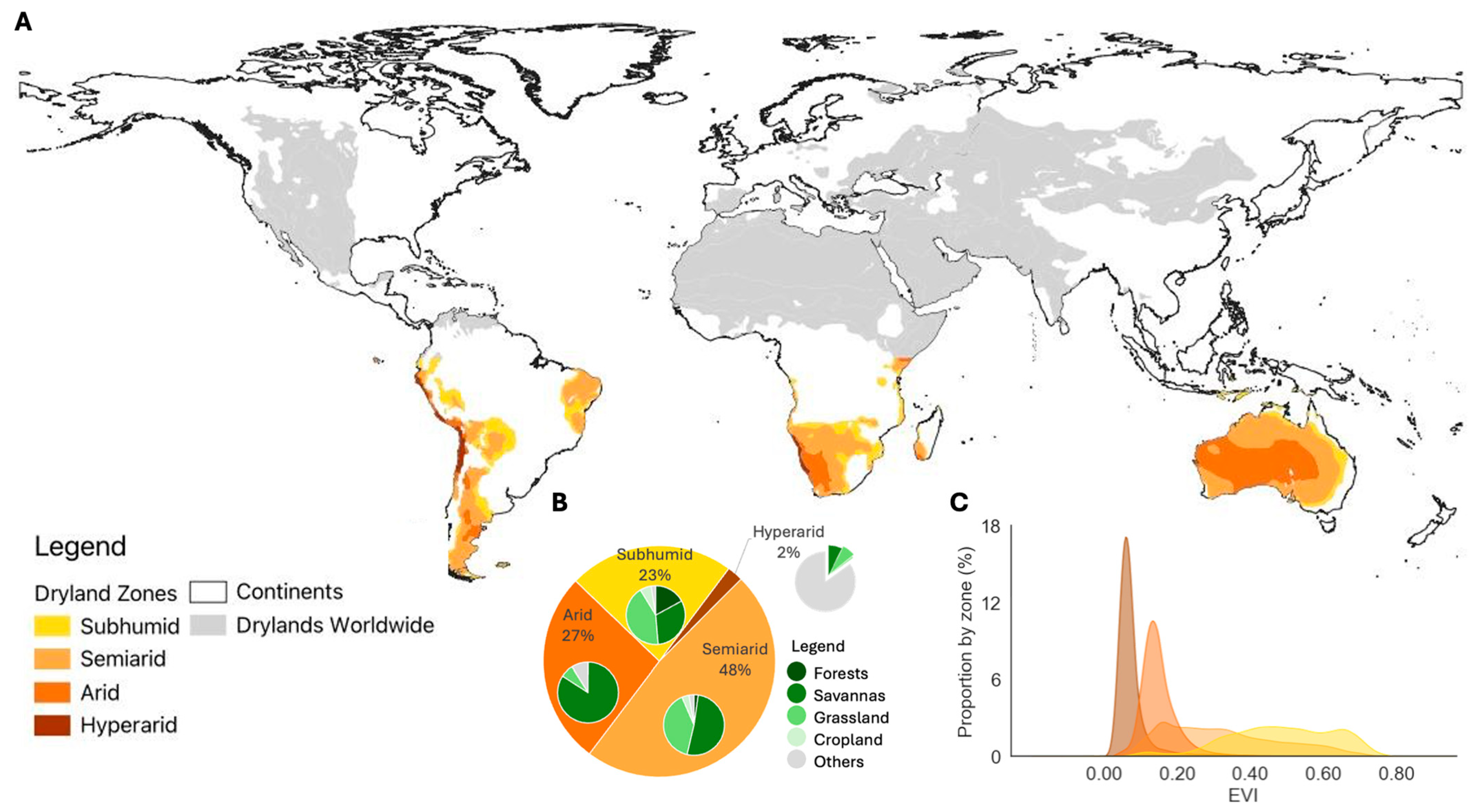
3.1. Characterization of Drylands and Vegetation Dynamics

Drylands are defined as regions where the ratio between annual precipitation and mean annual potential evapotranspiration (P/PET), known as the Aridity Index (AI), does not exceed 0.65 [10]. Drylands are typically classified into four distinct zones: hyperarid (16% of the global dryland area, AI < 0.05), arid (25%, 0.05 < AI < 0.2), semiarid (37%, 0.2 < AI < 0.5) and dry subhumid (22%, 0.5 < AI < 0.65) [10,14,44]. These regions cover substantial portions of the Earth’s land surface, occupying 32% of the African continent, 29% of Asia, 20% of the Americas, 11% of Oceania, and 8% of Europe [10]. The combination of climate variability and the extensive geographical distribution of drylands results in considerable spatial heterogeneity and diverse vegetation types [7], ranging from woodlands (18% of the total area) and shrublands (10%) to extensive herbaceous formations (25%) [10,28].
In this broader context, drylands in the SH account for approximately 22% of the global dryland extent (Figure 2A). These regions are predominantly classified as semiarid (48%), followed by arid (27%), dry subhumid (23%), and hyperarid (2%) zones. Remarkably, 91% of the SH drylands are vegetated, representing 35% of the world’s total vegetated dryland area. The vegetation cover is highly diverse, with savannas accounting for 55% of the vegetated area, followed by grasslands at 31%, and forests at 5%, as derived from the MCD12Q1 product [42] (Figure 2B).
Complex interactions between climate variability, hydrology, and soil properties drive high seasonal variability in vegetation dynamics. Additionally, factors such as herbivory, interspecific vegetation competition and recruitment, fire regimes, and human interactions further complicate the understanding of vegetation structure and functional dynamics in drylands [45]. These interactions, which vary regionally, can lead to changes in the vegetation structure and composition (Figure 2C), thereby influencing key biogeochemical cycles [7,28,46]. Among the ecological processes that influence such cycles, vegetation phenology plays a critical role and therefore contributes to understanding how ecosystems respond to environmental drivers [45].

3.2. Phenology of Natural Dryland Vegetation

Vegetation phenology encompasses key life cycle events, including leaf emergence, flowering, fruiting, senescence, and dormancy [47]. This study focuses specifically on leaf development, particularly the start and end of the growing seasons, as these phenophases are especially critical in regulating ecosystem productivity.
Phenological events are mainly controlled by environmental factors, with temperature, photoperiod, nutrients, and water availability being among the key determinants [2]. In dryland ecosystems, specifically, water availability and spatial–temporal variability of rainfall strongly drive the leaf phenology [7,27,45,48]. In these regions, vegetation density and productivity are closely tied to precipitation gradients [45,49], which shape long-term patterns in the ecosystem. In contrast, short rainfall events, often referred to as “pulses”, can trigger key functional processes such as respiration and gross primary production. These pulses often result in rapid vegetation greening [49], with the response magnitude varying according to the pulse size [45]. Consequently, drylands can exhibit multiple peaks of vegetative activity within a single year, with high interannual variability driven by rainfall patterns [7].
Climatic and biogeographic differences between the SH and Northern Hemisphere (NH) can lead to variations in phenological patterns and their environmental drivers [50]. The SH, characterized by a lower proportion of landmass and greater oceanic influence, tends to exhibit smaller temperature seasonality and milder extremes compared to the NH, particularly in the continental interiors [25,51]. Although both hemispheres include regions with moderate temperature regimes, many SH drylands are more likely to support year-round vegetation activity due to the absence of cold-induced dormancy [25]. As a result, phenological cycles in SH drylands are often less distinct compared to the strong winter dormancy observed at higher northern latitudes. For example, significant latitudinal differences have been reported in the correlation between temperature and the start of the growing season, suggesting that phenological sensitivity to warming varies greatly between hemispheres [52].
In general, the temperature and photoperiod are the dominant controls of leaf phenology in many NH drylands, whereas in SH drylands, phenological dynamics are predominantly, but not exclusively, driven by water availability [49,50]. This is exemplified in seasonally dry tropical forests in Brazil, dominated by semi-deciduous trees, where short-term rainfall events over seven days are sufficient to initiate leaf flush [48]. Given the diversity of rainfall regimes across global drylands and the strong variability and low predictability of rainfall events [7,53], the growing season patterns in SH dryland regions can be highly irregular. These characteristics, combined with vegetation types unique to the SH, such as the Miombo (a deciduous dry woodland restricted to SH tropical Africa [54]), contribute to distinctive phenological responses in this region.
Vegetation in drylands also exhibits morphological and physiological adaptations to cope with these environmental constraints. The root systems of natural dryland vegetation are particularly adapted to these conditions, typically remaining shallow to optimize water uptake during short-term rainfall events [45,48]. For example, woody species (trees and shrubs) with superficial roots found in Africa and South America frequently employ a short-term leaf growth strategy to maximize productivity while environmental conditions are favorable [45,55]. Many of these species synchronize their vegetative (leaf) and reproductive (flowers and fruits) development exclusively during the rainy season [47,56].
However, significant variability is observed in leaf phenology even within the same landscape scale, particularly due to differences in plant functional types and species composition. Woody species exhibit two primary drought-adaptive strategies: drought avoidance via deciduous phenology and drought tolerance in evergreen species. Deciduous woody species are typically photosynthetically active during the rainy season and enter dormancy as the dry season begins. In contrast, many evergreen species remain photosynthetically active throughout the year, supported by deeper rooting systems and greater access to stored soil moisture [45]. Herbaceous species, which often dominate the understory, typically respond more rapidly to environmental drivers and exhibit more pronounced seasonality than woody species [45]. Their photosynthetic activity is generally restricted to the rainy season, with dormancy beginning early in the dry season. As a result, this vertical and functional heterogeneity, from the understory to the canopy level, leads to complex variations in vegetation phenology at the landscape scale [47].
In addition to the cited drivers of leaf phenology, factors like fire, insect outbreaks, and wind significantly influence short-term phenological dynamics in drylands [45]. Fire, often exacerbated by human activities, is a critical disturbance in these ecosystems, frequently triggered by drought conditions. Fire events can cause immediate effects, such as leaf drop, as well as long-term reductions in vegetation productivity [45]. Moreover, many dryland species have evolved adaptive strategies for rapid post-fire responses, often initiating leaf flush soon after the disturbance [49].
In summary, leaf phenology in drylands is highly variable, influenced by a complex interplay of factors: (1) precipitation regimes and water availability; (2) species-specific traits (e.g., evergreen vs. deciduous); (3) environmental condition adaptations; and (4) external disturbances (e.g., fire). Understanding the structural and functional dynamics of vegetation, particularly the physiological processes along the soil–root–leaf–atmosphere continuum, is essential for advancing phenological research in drylands.
Recent advances in phenological monitoring have utilized three primary observation approaches: (i) visual observations, often maintained by citizen science networks and phenology monitoring programs; (ii) near-surface observations, such as RGB cameras on towers (e.g., Phenocams) or onboard unmanned aerial vehicles (UAVs); and (iii) orbital observations using satellite-based sensors from geostationary and polar orbits [2,3,47]. While ground-based and near-surface methods offer high-resolution data, their utility in drylands is limited by challenges in spatial and temporal coverage [7,47], particularly in the SH. These limitations are largely mitigated by orbital remote sensing, enabling phenological studies at large spatial and temporal scales.

4. Remote Sensing-Based Phenology: Concepts and Advances

LSP refers to “the study of seasonal patterns in vegetation observed through remote sensing” [23]. Unlike field-based observations that focus on specific plants or small communities, satellite sensors capture the entire landscape within their field of view (FOV), providing a more integrative observation [3]. This ability to observe broad-scale ecosystems over time has made LSP an invaluable tool for understanding ecosystem processes and their dynamic responses to environmental change [57,58]. The effectiveness of LSP in monitoring vegetation phenology stems from the sensitivity of satellite sensors to variations in the foliar component [3], which is the primary element of the canopy interacting with electromagnetic radiation. However, factors such as photosynthetic activity, the percentage of canopy closure, and background effects (i.e., soil) critically influence the seasonal spectral responses detected by the sensor [59].
The availability of long-term and standardized satellite time series [22] has enabled the consistent monitoring of vegetation phenology across local and global scales [60], supporting the expansion of LSP research into diverse ecosystems, including temperate and boreal forests [8,61,62,63], rangelands [64,65], and tropical forests [66,67,68]. The growing availability of high-resolution satellite data from sensors such as Sentinel-2 and PlanetScope has significantly improved the extraction of phenological metrics at finer spatial and temporal scales, enabling more detailed analyses of vegetation dynamics [21,69]. LSP-derived metrics have also been widely integrated into land use and land cover (LULC) classification frameworks to support the discrimination of vegetation types. However, much of the current research remains focused on croplands [69,70].
Expanding the use of LSP analysis and advancing the development of remote sensing-based phenological products across diverse biomes depends on the availability of robust and well-established frameworks for processing and extracting phenological information from remote sensing time series. Typically, this process involves three key steps: (1) quality assurance and noise removal; (2) smoothing and reconstruction of the time series; and (3) extraction of phenological metrics from the reconstructed data [7,21], which are briefly described in the following sections.

4.1. Phenological Metrics

The terminology and definitions of phenological metrics derived from remote sensing time series vary considerably, reflecting the diverse approaches adopted across observation types (e.g., greenness proxy dataset) and methodologies applied [3,8,71,72]. Broadly, LSP metrics cover key stages of the vegetation cycle, including the start of the growing season (greening), maturity, senescence, and the end of the growing season (dormancy). Additional metrics, such as the length of the growing season, amplitude, and peak, are also commonly extracted to refine the analysis [73]. For the purposes of this review, we adopted the phenological metrics defined in two ready-to-use LSP products [73,74], as summarized in Table 1.

4.2. Time Series

4.2.1. Orbital Sensors

Orbital sensors used for LSP studies exhibit a wide range of spatial resolutions (from 3 m to over 25 km) and temporal resolutions (from 10 min to 16 days). The Landsat constellation, operational since 1972, pioneered long-term phenological monitoring, setting a foundation for LSP studies. Other sensors, such as MODIS (Moderate Resolution Imaging Spectroradiometer), VIIRS (Visible Infrared Imaging Radiometer Suite), and AVHRR (Advanced Very High-Resolution Radiometer) are frequently used due to their high temporal resolution, which allows for more continuous phenological monitoring across various ecosystems.
However, the trade-off between spatial and temporal resolution among these widely used sensors remains a key limitation (Table 2). For instance, the Landsat constellation offers medium spatial resolution (30–60 m) across visible and near-infrared spectral bands, but its low temporal resolution (16 days) often limits the detection of rapid changes in vegetation phenology [64]. This limitation is further compounded by cloud cover, which can severely reduce the number of good-quality images, limiting the ability to construct a continuous and representative time series [75].
In contrast, sensors with high temporal resolution (e.g., daily observations) generally have coarser spatial resolution. While these moderate-to-low spatial resolution sensors (e.g., MODIS and AHI—Advanced Himawari Imager) perform well in homogeneous and high vegetation cover regions [22], they tend to underrepresent vegetation dynamics in heterogeneous or sparsely vegetated landscapes [7]. The temporal stability of these products stems from spatial averaging over large areas [27,56], but such aggregation can obscure subtle phenological signals and reduce metric accuracy [27].
Advances in remote sensing have shown significant potential in improving the detection of key phenological events. For example, Sentinel-2 satellites combine high spatial resolution (10 m) with a 5-day revisit frequency [69], enabling finer observations of seasonal transitions. Several studies have reported strong correlations between the Normalized Difference Vegetation Index (NDVI) time series from Sentinel-2 and MODIS with field-based phenological observations across different ecosystems [56,61]. However, substantial variability in the accuracy of SOS and EOS estimates has been documented, particularly in drylands and seasonal forests, where cloud cover and limitations in cloud-masking algorithms compromise the consistency of satellite-derived metrics [56,76].
Recent studies have also explored the integration of Sentinel-2 and Landsat-8 data, resulting in the Harmonized Landsat Sentinel (HLS) product [77]. HLS offers 30 m spatial resolution with an approximate 2-day revisit frequency and has shown promising agreement with field-based phenological observations in drylands and grasslands [78,79]. Despite these advances, cloud-masking accuracy in HLS products remains a limiting factor, with reported accuracies ranging from 76% to 89% [79].
For long-term phenological assessments—essential for understanding ecosystem responses to climate change—data fusion approaches involving MODIS and Landsat have proven valuable [80,81,82]. Additionally, the NDVI time series from the Global Inventory Monitoring and Modeling System (AVHRR/GIMMS) dataset, which spans over 45 years, has been widely used to investigate long-term shifts and anomalies in vegetation seasonality [60,83,84,85,86]. However, studies have shown that differences in sensor characteristics (e.g., spectral bandwidth, resolutions, and viewing angle) and data processing methodologies can lead to inconsistencies in LSP estimates, even when using the same sensor (e.g., AVHRR series) or across sensors (e.g., MODIS vs. AVHRR) [60].

4.2.2. Vegetation Indices

Vegetation indices (VIs) are among the most widely used proxies for analyzing time series in the extraction of phenological metrics. NDVI is a pioneering index for global-scale LSP monitoring and remains the most applied proxy for detecting vegetation greenness. Other indices, such as the EVI and Soil-Adjusted Vegetation Index (SAVI), are also commonly used in these analyses [3].
NDVI, however, is particularly susceptible to background interference (e.g., soil reflectance) and atmospheric effects [87]. To mitigate such effects, indices like the SAVI, which incorporate soil-line corrections, are frequently employed in areas with significant soil influence [56]. EVI has demonstrated superior performance in capturing vegetation properties relative to NDVI, particularly in its ability to minimize soil and atmospheric effects [57,88,89,90]. However, EVI’s reliance on the blue spectral band limits its applicability in some sensors, and even then, there may be compatibility issues across sensors due to differing spectral bandwidths [74]. To address these limitations, EVI2 has emerged as a more adaptable and widely applicable index, reducing the need for the blue band while maintaining strong correlations with near-surface observations [57,91]. EVI2 is also used in operational LSP products such as MCD12Q2 [92] and VNP22Q2 [93].
Most VIs used in LSP are based on a combination of red and near-infrared spectral bands due to their complementary relationship: the visible spectral region is closely linked to photosynthetic pigment content, while the near-infrared spectral region corresponds to the leaf structure [59]. New VIs have been developed specifically for phenological applications, such as the Normalized Difference Phenology Index (NDPI) [94]. Additionally, the introduction of sensors with enhanced spectral capabilities, such as Sentinel-2, has enabled the development of novel indices tailored to phenology. For example, red-edge-based indices like the Normalized Difference Red-Edge (NDRE) and the Red-Edge Chlorophyll Index (CIred-edge) have demonstrated greater stability in detecting the SOS and EOS, offering enhanced sensitivity to chlorophyll content compared to the NDVI. This is because chlorophyll absorption is less pronounced in the red-edge region than in the red region, allowing for the improved detection of subtle vegetation changes [69,94]. Another widely adopted index for phenological studies across multiple platforms, including both orbital and near-surface sensors, is the Green Chromatic Coordinate (GCC) [56,95,96]. GCC operates within the blue, green, and red bands due to limitations in some near-surface cameras restricted to these visible spectral channels.

4.2.3. Smoothing and Reconstruction of Time Series

Time series derived from remote sensing-based vegetation indices often contain noise caused by cloud contamination, atmospheric conditions, and sensor inconsistencies. To minimize these effects and obtain a more representative seasonal signal to reflect vegetation dynamics, smoothing techniques are essential and directly influence the accuracy of phenological metrics. Smoothing methods can be broadly classified into empirical techniques and curve-fitting models, although other classifications also exist [21].
Empirical techniques, such as moving average filters [97] and interactive interpolation [98], are simple and computationally efficient. However, they are highly sensitive to input parameters and are less effective when handling time series with large gaps or irregular sampling [21].
Curve-fitting models are the most widely used smoothing approaches. These include Gaussian [99], logistic [100,101], and Savitzky–Golay filters [102]. While the latter requires local parameter calibration for optimal performance, Gaussian and logistic functions tend to be more robust under varied data conditions [103]. For instance, the global operational MODIS MCD12Q2 product uses a double logistic model to smooth the time series [73]. Despite their flexibility, curve-fitting models may over-smooth data and mask short-term vegetation dynamics, particularly in ecosystems with weak or noisy signals [21,104].
Studies have also explored the potential of Generalized Additive Models (GAMs) to smooth time series [22,48]. Unlike traditional linear models, GAMs use non-parametric functions that adapt to non-linear trends and irregularly spaced observations [22]. This adaptability makes GAMs particularly suitable for phenological studies with irregular temporal patterns. For instance, recent adaptations of GAMs have been successfully applied to model phenological patterns in drylands vegetation, demonstrating their efficacy in handling heterogeneous environmental data [48,56,105].
Preprocessing steps such as temporal compositing (e.g., 8- or 16-days MODIS maximum NDVI value composites) are commonly applied prior to smoothing to mitigate artifacts such as cloud and shadow contamination, off-nadir viewing angles, and solar angle variations [21]. While these approaches provide more stable time series, they may also remove short-duration phenological events, particularly relevant in drylands.

4.2.4. Methods for Extracting Phenological Metrics

Once the time series are smoothed, various methods can be applied to extract phenological metrics (Table 1). These methods are typically grouped into threshold-based and change-detection approaches [21], with recent interest growing in machine learning models [106].
Threshold-based methods define phenological events as points where vegetation indices cross predefined thresholds—either absolute or relative (e.g., a percentage of seasonal amplitude) [21]. For example, the MODIS MCD12Q2 product estimates SOS and EOS using dynamic thresholds set at 15% of the amplitude [73]. These methods have also been adopted in several other studies [85,86,105,107,108,109,110,111,112] due to their simplicity. However, they often require local calibration and are sensitive to interannual variability, especially in heterogeneous or fragmented ecosystems [106,113].
Change-detection methods detect phenological transitions by identifying inflection points or shifts in the time series curves [21]. Popular methods include the moving average [21,106,114], curve derivatives [56,106], curvature change rate [75,115], and relative change rate [63]. These techniques are better suited for capturing transitional dynamics but are also more sensitive to noise and data gaps.
In recent years, machine learning algorithms have shown promise for phenological metric extraction. Models such as random forests and artificial neural networks can integrate multiple data sources and model complex non-linear relationships. Comparative studies indicate that ML models can perform well in densely vegetated or homogeneous areas, but their effectiveness in drylands is limited by vegetation heterogeneity and the need for large, well-distributed training datasets, which can increase both computational complexity and processing time [106].

4.3. LSP Ready-to-Use Products

In recent decades, several operational LSP products have been developed to enable the large-scale monitoring of vegetation phenology, particularly at moderate-to-coarse spatial resolutions (500 m to 5 km) [57]. Among the most widely used is NASA’s MCD12Q2 [73,92], which provides global phenological metrics (23 attributes per pixel) derived from EVI2 time series at 500 m resolution, covering data from 2001 onward. It delivers information on up to two annual vegetation cycles per pixel (i.e., when the EVI2 amplitude exceeds 0.1) [73,115], though complete validation remains limited [73,92].
The VIPPHEN product (Global Vegetation Index and Phenology Multi-Sensor Phenology) [74] integrates long-term AVHRR and MODIS data to estimate up to three phenological cycles per year (seven attributes per pixel) at a spatial resolution of 0.05°. Phenological metrics are computed only when vegetation index thresholds are met (e.g., NDVI > 0.12 and EVI2 > 0.08), and growing seasons are identified based on minimum amplitude criteria (e.g., 0.05 for NDVI and 0.03 for EVI2). Its uncertainties vary for up to 30 days, particularly in areas with sparse vegetation cover [74].
In addition to long-established MODIS- and AVHRR-based products, more recent operational LSP datasets have been developed with improved spatial resolution. At the global scale, Copernicus (https://land.copernicus.eu/en/dataset-catalog, accessed on 14 July 2025) has launched phenology products at 300 m resolution, offering finer spatial details compared to earlier global products. Regionally, Copernicus also provides high-resolution phenology products for Europe, based on Sentinel-2 imagery (10 m), enabling the more accurate detection of seasonal dynamics in fragmented and heterogeneous landscapes. These newer products represent an important advancement in phenological monitoring using higher-spatial-resolution datasets.

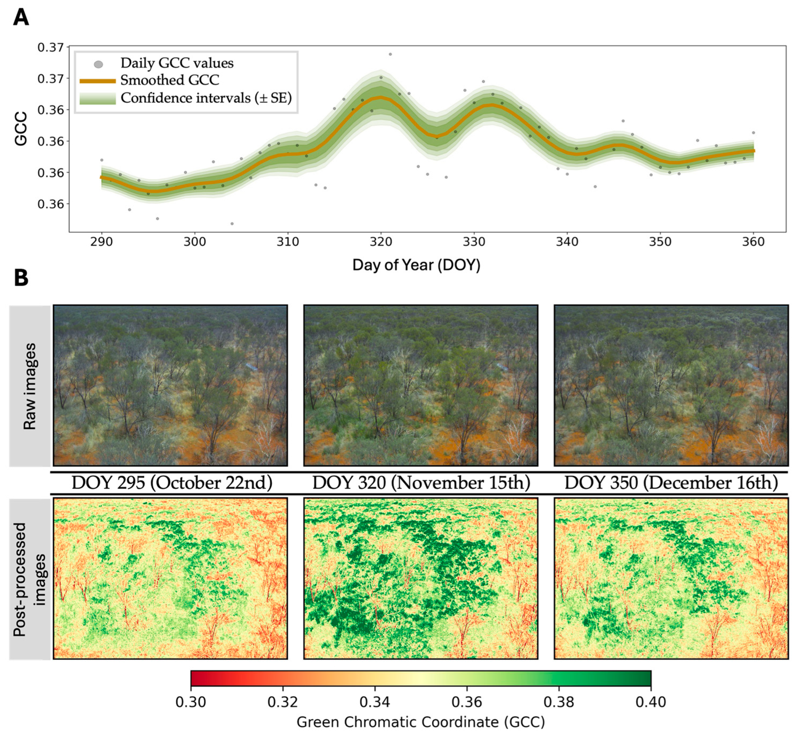
4.4. Ground and Near-Surface Phenology

The advent of orbital remote sensing has improved phenological research, enabling unprecedented insights into vegetation seasonality across spatial and temporal scales. Yet, despite this progress, many satellite-derived phenology products remain weakly validated, particularly in regions where ground-based or near-surface data are sparse or absent, limiting their capacity to provide accurate ecological information [62,116].
In the Northern Hemisphere, long-term terrestrial monitoring networks have played a pivotal role in advancing LSP studies [27,49,96,117]. Well-established initiatives such as the USA National Phenology Network (USA-NPN [118]), Chinese Phenological Observation Network (CPON [119]), and Pan European Phenological Database (PEP [120]) have created robust temporal baselines and fostered model validation. By contrast, dryland ecosystems—particularly in Africa and South America—remain critically underrepresented in ground long-term observation networks [7]. In South America, for instance, the Tropidry network, a 20-year effort focused on tropical dry forests, is the only long-term phenological initiative identified to date [47,121].
Technologies such as near-surface digital repeat photography—e.g., Phenocams (Figure 3)—have emerged as reliable tools for continuous vegetation phenology monitoring at local scales, offering extremely fine temporal resolutions and filling part of the gap from terrestrial monitoring networks [27,48,56,95,104,105,122]. The PhenoCam network is the leading global platform, providing freely available data from diverse landscapes [95] and more recent regional initiatives in the Southern Hemisphere, e.g., e-phenology (Brazil) [123] and the Terrestrial Ecosystem Research Network (Australia) [124], are advancing this field. Yet, one of the key challenges is to understand the sources of variability between observations across different spatial and temporal scales, especially important for improving the accuracy and the ecological understanding of remote sensing-based phenology in dryland ecosystems [62].

5. Contributions, Limitations, and Perspectives of Land Surface Phenology for Dryland Ecosystems in the Southern Hemisphere

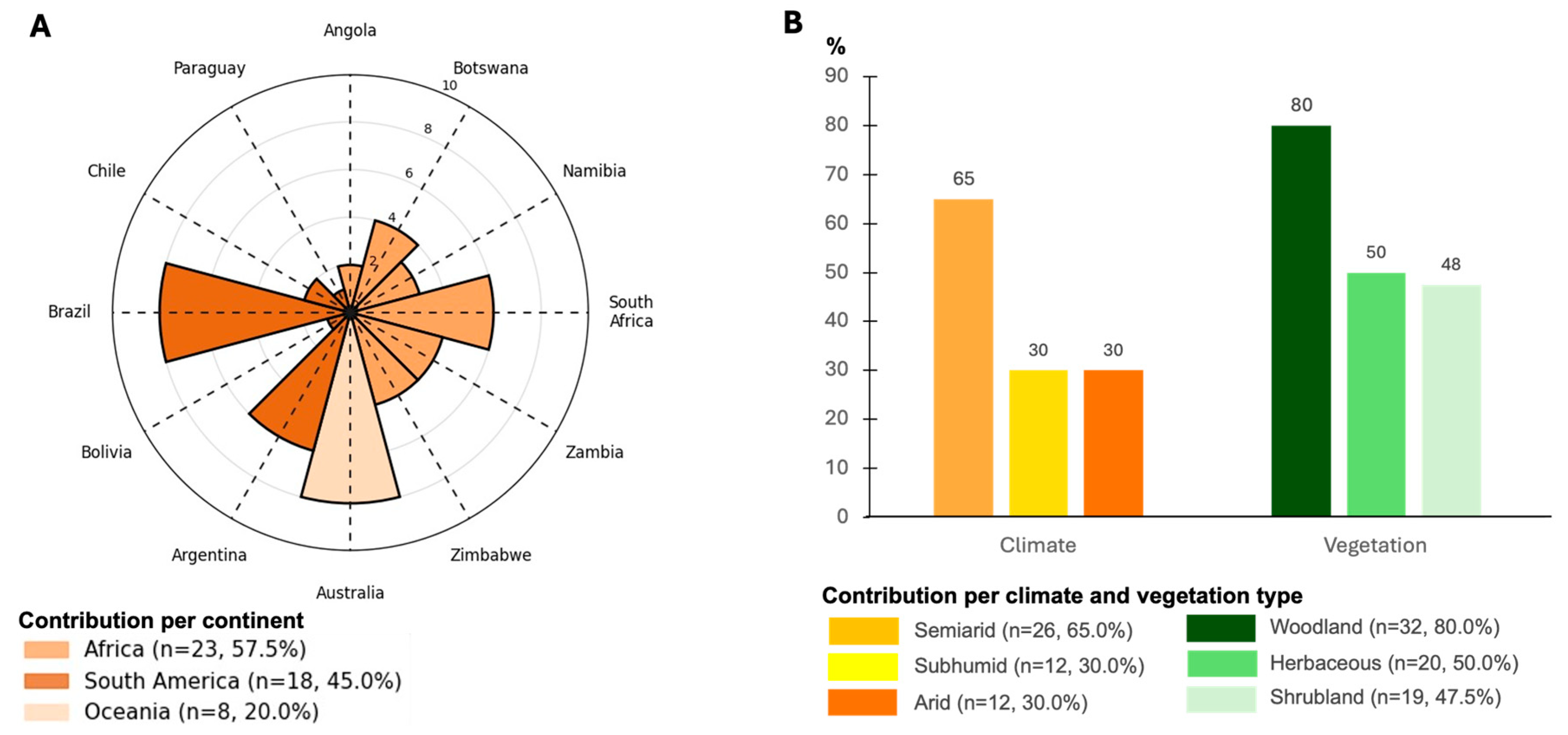
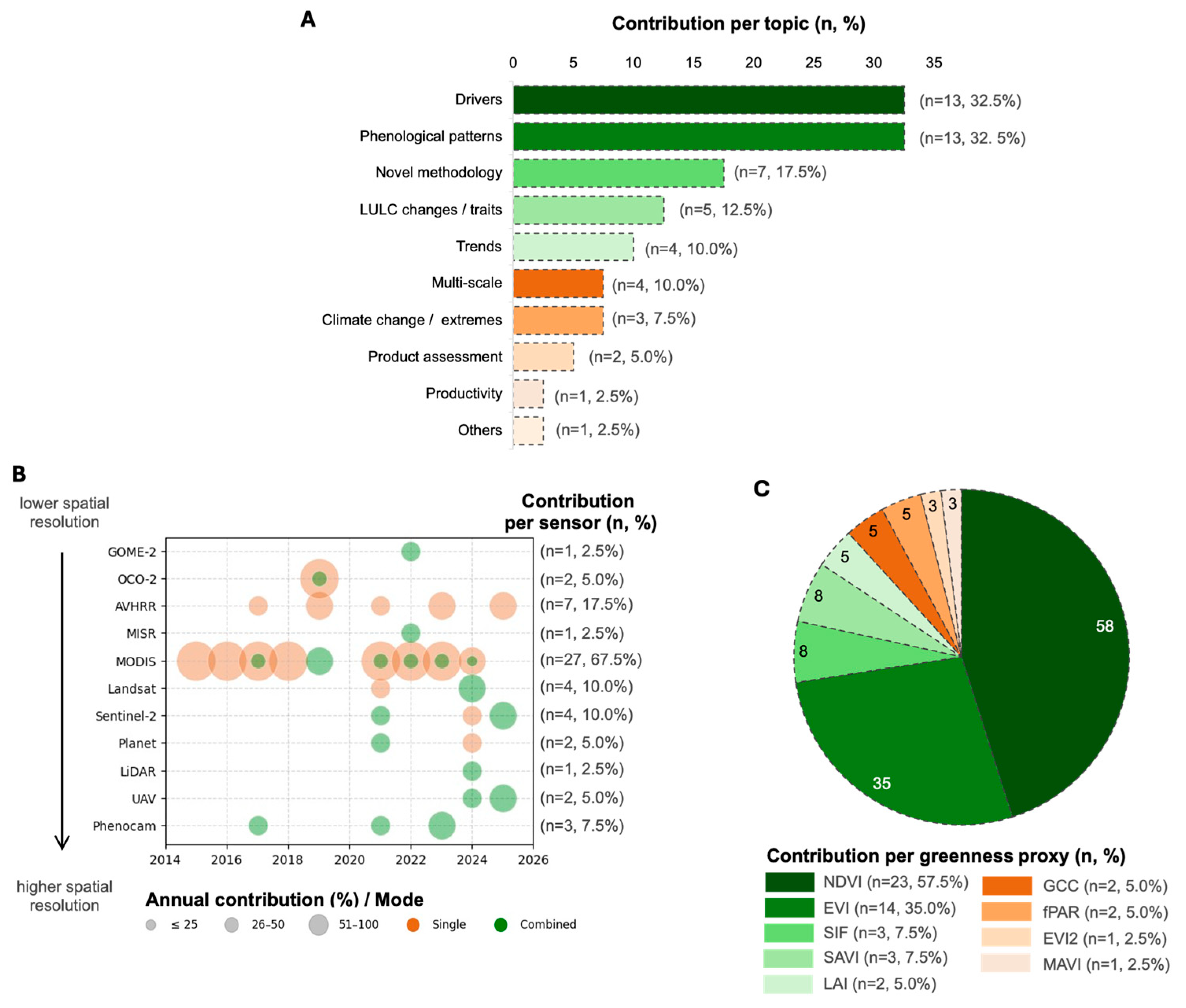
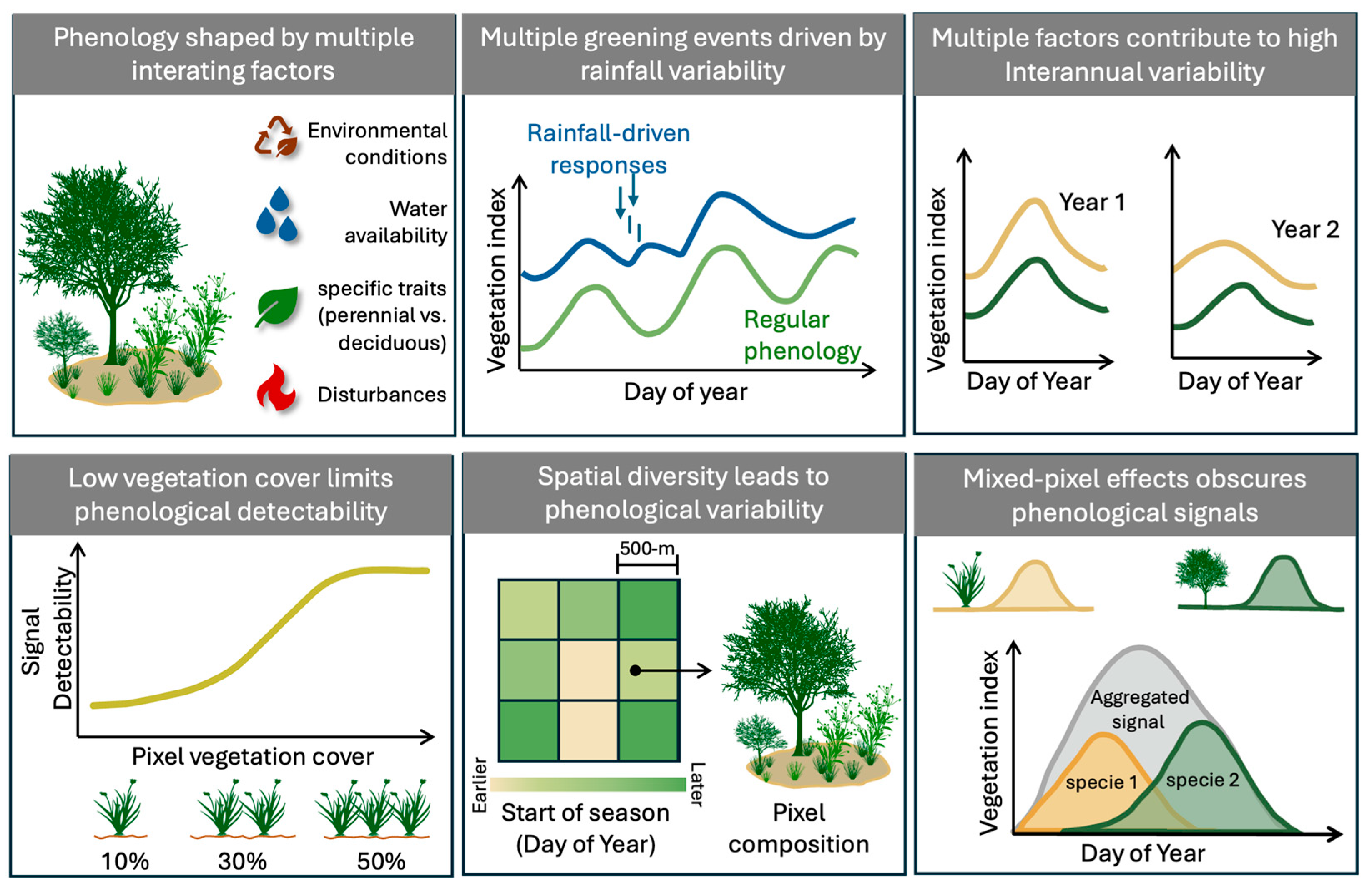
5.1. Current Developments and Limitations

Despite the pronounced vegetation heterogeneity and distinct phenological patterns characterizing SH drylands, these regions remain critically underrepresented in the scientific literature. The review of Scopus-indexed studies reveals that only approximately 14% of research on vegetation phenology in drylands focuses on the SH. This highlights a substantial knowledge gap in understanding the phenological dynamics of these globally significant regions and the application of remote sensing methods.
The systematic review identified 40 studies addressing phenology in SH drylands, with a marked regional bias in research efforts. The majority of studies (57.5%) were conducted in African countries—particularly South Africa (frequency, n = 6), Zambia (n = 4), and Zimbabwe (n = 4), followed by South American countries (45.0%), led by Brazil (n = 8) and Argentina (n = 6). Studies from Oceania accounted for only 20.0%, primarily in Australia (n = 8) (Figure 4A).
When stratified by climatic zones (Figure 4B, left), most studies focused on semiarid regions (n = 26, 65.0%), while arid and dry subhumid regions were equally represented (n = 12, 30.0% each). Notably, hyperarid regions were absent from the reviewed literature, underscoring a critical gap in remote sensing-based phenological studies across extreme climates. A similar bias was observed across vegetation types (Figure 4B, right), with a strong focus on woodlands (n = 32, 80.0%)—also grouped with savannas, dry forests, and miombo ecosystems. In contrast, herbaceous-dominated landscapes (n = 20, 50.0%) and shrublands (n = 19, 47.5%) were comparatively less studied, despite their ecological relevance and phenological sensitivity in dryland functioning.
This review also revealed a strong emphasis on understanding the drivers of vegetation phenology (n = 13, 32.5%) and phenological patterns (n = 13, 32.5%) (Figure 5A). A smaller proportion of studies also explored novel methodologies for phenological monitoring (n = 7, 17.5%) and the effects of LULC changes and traits (n = 5, 12.5%) on the phenology. Topics such as multi-scale assessments (n = 3, 7.5%), climate extremes (n = 3, 7.5%), product evaluation (n = 1, 2.5%), and productivity (n = 1, 2.5%) were notably scarce. Each comprised less than 10% of the reviewed literature, highlighting key priorities for future research.
Sensor usage patterns showed a dominant reliance on MODIS data, which was used in 67.5% of the studies (n = 27), primarily due to its high temporal resolution and long-term data availability (Figure 5B). AVHRR, with the product GIMMS NDVI3g [126], was the second most common (n = 7, 17.5%), followed by Landsat (n = 4, 10.0%), Sentinel-2 (n = 4, 10.0%), and Phenocam networks (n = 3, 7.5%). A growing trend towards multi-sensor approaches was observed after 2020, with studies combining data sources to bridge temporal and spatial gaps. However, high-resolution platforms such as UAV (n = 2, 5.0%) and PlanetScope (n = 2, 5.0%) remain underutilized.
Regarding vegetation indices (Figure 5C), NDVI was the most frequently used (n = 23, 57.5%), followed by EVI (n = 14, 35.0%). Other indices such as SAVI (n = 3, 7.5%) and GCC (n = 2, 5.0%) were less frequently applied. Although NDVI has been extensively employed, its limitations in drylands are well-documented. NDVI’s sensitivity to soil background reflectance can introduce substantial uncertainty in phenological estimates [127]. For instance, some studies report discrepancies of up to 24 days in SOS detection compared to indices such as EVI, SAVI, and NDPI—and up to 42 days relative to field-based observations. For EOS, uncertainties were observed for up to 16 days [56,127].
Seasonal and spatial variations in the solar zenith angle can significantly bias vegetation indices, thereby affecting the accuracy of derived phenological metrics. Ma et al. [128] showed that NDVI is particularly susceptible to these biases compared to EVI. These findings highlight the importance of considering bidirectional reflectance distribution function-based corrections and ensuring consistent sun-angle normalization to enhance the reliability of LSP analyses across drylands [128,129]. Despite these limitations in VIs, reliance on traditional greenness-based indices persists, which may constrain the detection of phenological variability in drylands. Emerging alternatives, such as SIF, the leaf area index (LAI), and the fraction of absorbed photosynthetically active radiation (fPAR) time series, offer promising opportunities for capturing physiological and structural vegetation changes. Yet, their application in dryland phenology remains limited, with fewer than seven studies employing these approaches across the SH [30,130,131,132,133,134,135].
Among the phenological metrics analyzed, SOS and EOS were the most assessed, yet their detection in drylands remains challenging. SOS estimates are commonly linked to rainfall timing and intensity, rendering detection highly sensitive to atmospheric conditions and rapid vegetation responses. Studies using high-temporal-resolution sensors such as MODIS and AVHRR report relatively low discrepancies in SOS detection compared to field observations [56,136]. In contrast, EOS detection is more influenced by slow seasonal changes in background reflectance, leading to greater uncertainties, especially with coarse-resolution sensors. High-spatial-resolution platforms, such as Sentinel-2 and PlanetScope, have shown improved performance in detecting senescence phases [56,137].
Given these challenges, several studies have explored alternative or complementary metrics—such as peak, amplitude, or length of the growing season—which tend to provide less biased and more robust indicators of seasonal dynamics in low-amplitude ecosystems [27,137]. A few studies have also introduced less conventional metrics, including the Rate of Average Falling (RAF), Dry Season Integral (DSINT) [138], Rate of Spring Green-Up (RSP), and Rate of Autumn Senescence (RAU) [133], aiming to capture transitional or less-pronounced phenological processes.
Methodological approaches for time series smoothing and phenological metric extraction varied widely across studies, with no clear consensus on best practices. The Savitzky–Golay filter was the most commonly applied smoothing technique (n = 10, 25%) [85,86,105,107,108,122,132,139,140,141], while the amplitude threshold method was the most frequently used approach for extracting phenological metrics (n = 9, 22.5%) [85,86,105,107,108,109,110,111,142]. Less commonly used methods included singular spectrum analysis (SSA) [30,112], derivatives [56], and curvature rate analysis [75]. Despite the widespread application of these techniques, few studies systematically assessed their accuracy or potential biases. The performance and reliability of these methods depend on several factors, including vegetation type, data quality and resolution, landscape heterogeneity, and study objectives. These factors affect not only the extraction of phenological metrics but also the interpretation of long-term trends [3,60,103].
Finally, key vegetation characteristics in drylands, including heterogeneity, percentage cover, and strong seasonal variability, play a pivotal role in the accuracy and reliability of LSP detection regardless of sensor resolutions [27,57]. For instance, evergreen vegetation shows consistent detectability only when the pixel vegetation cover exceeds 50%, whereas detection is not feasible in pixels with less than 10% cover [57]. Similarly, phenology in deciduous shrubs becomes reliably detectable only when vegetation covers at least 20–30% of the pixel [27].
This behavior occurs because high proportions of exposed soil often obscure vegetation signals, rendering the growing season indistinguishable from dormancy in sparsely vegetated areas [143]. Since changes in VIs are directly influenced by the proportions of different materials within each pixel, phenology detection is highly sensitive to pixel composition [57]. In drylands, where vegetation is diffusely distributed and non-vegetated surfaces are unevenly dispersed within pixels, the likelihood of detecting pixels with vegetation cover exceeding 10% increases with higher-spatial-resolution sensors [57]. This limitation underscores why current LSP products based on moderate-to-low-resolution sensors (e.g., MODIS, AVHRR, and VIIRS) often fail to accurately capture phenological patterns in some dryland regions [57,142]. For example, shrublands in Australia are frequently omitted from products like MCD12Q2, which rely on amplitude thresholds (i.e., ≥0.1) that are inadequate for detecting phenology in ecosystems with low seasonal amplitudes. Such thresholds, although widely used, fail to account for the unique characteristics of drylands, resulting in the frequent misclassification or omission of these regions [7,142,144].
Beyond spatial-resolution constraints, a major source of uncertainty in LSP detection is the mixed-pixel effect, wherein a single pixel contains a mosaic of vegetation types, each with distinct phenological responses [145,146]. The aggregated signal does not capture the true dynamics of individual vegetation components, complicating the attribution of observed phenological shifts. This issue is particularly pronounced in heterogeneous landscapes where understory vegetation (e.g., grasses and shrubs) interacts with or masks the overstory signals from the tree canopies [49]. The high spatial heterogeneity and species diversity in drylands further exacerbate these challenges, making it difficult to disentangle the contributions of individual vegetation types to the overall landscape phenology. Despite the significance of this issue, mixed-pixel effects and vegetation-layer interactions remain underexplored in SH drylands (e.g., [131,147,148]).
Another limitation in accurately assessing dryland phenology arises from the occurrence of multiple vegetation greenness peaks within the same growing season, a pattern often associated with bimodal or multimodal phenology [149]. These patterns may emerge from asynchronous responses of coexisting vegetation types (e.g., grasses vs. woody plants) with divergent phenological strategies [117] or from species whose growth dynamics are highly modulated by climate interactions [150]. Despite their ecological relevance, neither the reviewed studies nor the cited global LSP products explicitly quantified the metrics associated with these seasonal patterns.
Accurately defining and mapping natural dryland vegetation is another persistent challenge. LULC maps in drylands often exhibit lower accuracy compared to other ecosystems, with notable inconsistencies across scales and datasets [151]. For example, classification discrepancies have been observed between MapBiomas [152], MODIS Land Cover Type [153], and Improved FROM-GLC [154] datasets, reflecting the inherent difficulty of representing the structural and spectral heterogeneity of dryland ecosystems [29]. These inconsistencies propagate into LSP analyses, introducing uncertainty in the characterization of phenology patterns. However, many studies fail to address these underlying limitations or to account for long-term LULC changes, which further constrain phenological interpretation in dryland regions [72,155]. While broad-scale assessments are valuable for global analyses, such generalizations may obscure the nuanced phenological dynamics that characterize these ecosystems.
These challenges illustrate why drylands remain one of the most complex ecosystems for phenology detection by remote sensing. In summary, the primary limitations in estimating and interpreting LSP information include the following: (1) the low performance of optical remote sensing-based VIs in sparse vegetation, where low vegetation signals are frequently masked by background effects; (2) methodological assumptions of one or two distinct seasonal cycles per year, which fail to capture the irregular VI peaks driven by precipitation pulses; (3) the trade-off between spatial and temporal resolution in current satellite products, where coarser sensors may obscure fine-scale phenological dynamics, particularly in heterogeneous vegetation landscapes; and (4) the limited accuracy of LULC classifications in drylands, which stems from the challenge of capturing their inherently heterogeneous and diverse vegetation types [7,27] (Figure 6).

5.2. Perspectives and Emerging Opportunities

The spatial and temporal resolution desired for phenological studies in drylands often exceeds the capabilities of current orbital sensors, highlighting the need for advanced approaches such as multi-sensor data integration. Recent advancements, including the launches of Landsat-9 (2021) and the Sentinel-2C (2024) satellites offer promising opportunities for multi-sensor approaches. Together with data from existing platforms like Landsat-8 and Sentinel-2A, these satellites will strengthen the Harmonized Landsat and Sentinel-2 (HLS) dataset, offering free, medium-spatial-resolution imagery with high revisit frequency. Additionally, nanosatellite constellations such as PlanetScope have the potential to enable finer-scale analyses, supporting community- and species-level phenological assessments. Such capabilities are particularly valuable for detecting specific processes, including flowering, with unprecedented temporal and spatial detail [104].
Beyond traditional reflectance-based VIs derived from visible and near-infrared bands, emerging products that capture physiological parameters offer new opportunities to enhance the sensitivity of phenological detections. SIF, for instance, is inherently insensitive to soil reflectance and shows promise for detecting rapid vegetation responses to precipitation events and stressors [7,156]. However, SIF time series often exhibit low seasonal amplitude in areas with sparse vegetation cover [30], limiting its utility in some regions. Similarly, VOD, derived from passive microwave sensors, is sensitive to total aboveground biomass water content and may allow discrimination between woody and herbaceous vegetation, while remaining less affected by atmospheric and cloud interference [157,158]. Although its coarse spatial resolution (e.g., ~25 km) limits detailed applications, VOD holds potential for monitoring large-scale vegetation dynamics.
Despite not being represented among the studies included in this systematic review, Synthetic Aperture Radar (SAR) data have also shown potential for phenological applications [69], particularly in croplands [159]. Integrating SAR with optical datasets remains challenging due to the weak backscatter response of foliage and the computational demands of SAR processing [8]. However, advances in synergistic SAR-optical approaches could significantly expand the capabilities of phenological monitoring in drylands, particularly in persistently cloudy regions where optical sensors are insufficient.
A critical limitation in current methods for extracting phenological metrics lies in their reliance on mathematical point-detection techniques, which often lack a physiological basis and may fail to capture true phenological transitions [21,27]. Emerging technologies such as LiDAR (e.g., GEDI) and hyperspectral sensors (e.g., PRISMA) offer the ability to capture structural and biochemical vegetation information that can refine our understanding of how phenological transitions are reflected in traditional observations [131]. Spectral mixture analyses also hold promise for disentangling signals in heterogeneous vegetation landscapes, potentially improving metric accuracy across diverse vegetation cover types [27,57,104,138,145]. Furthermore, incorporating the methodologies capable of detecting intra-phenological variability and multiple greening peaks (e.g., [117,150]) could enhance our understanding of the functional diversity strategies that drive vegetation responses in drylands. Machine learning approaches have shown potential for extracting phenological metrics from complex datasets, yet their performance remains variable across different metrics and ecosystem contexts [27,106]. In drylands specifically, their applicability requires further evaluation to understand its performance across different vegetation types and percentage cover [3,27,45].
These methodological advancements must be coupled with consistent ground-based and near-surface phenological observations for calibration and validation. The persistent scarcity of such observations in drylands, especially across the SH, represents a critical barrier to advancing phenological studies. Emerging opportunities are particularly relevant for South America, where vast dryland regions remain underrepresented in phenological research, contributing to the geographic bias identified in this systematic review. Furthermore, the disproportionate focus on woody vegetation in existing research may hinder our ability to fully understand the distinct seasonal dynamics of herbaceous and shrub components, particularly in heterogeneous landscapes.
Although projections indicate a drier SH under climate change scenarios [160], recent trends reveal substantial regional and seasonal precipitation changes [161]. Over the past five decades, large areas of drylands in South America have experienced rainfall declines, while certain regions in South Africa and Australia have shown the opposite trend [161]. Notably, drier autumns have been documented across semiarid zones such as southern-coastal Chile, southern Africa, and southeastern Australia [162], highlighting the seasonal and spatial heterogeneity of hydrological shifts. Yet, how these divergent rainfall changes, whether intensified or reduced, affect vegetation responses across SH drylands remains poorly understood [163]. For instance, NDVI-based analyses have shown that nearly 29% of the global vegetation experienced significant shifts in the timing and duration of the growing seasons between 1982 and 2013 [60]. In drylands, these shifts have exhibited contrasting patterns, ranging from shortened growing seasons in Southern Africa and Northern Australia [60] to extended duration in other regions [136,164], trends that are also likely influenced by rising atmospheric CO2 concentrations [2,7,165]. However, the magnitude, direction, and mechanisms of these phenological responses remain uncertain [164], underscoring the critical role of LSP in detecting, interpreting, and forecasting ecological changes in a warming and increasingly variable climate [58]. Long-term and spatially distributed observations are urgently needed to disentangle the effects of climate variability from other ecological drivers, allowing more accurate projections of dryland ecosystem functioning under global change.

6. Conclusions

This review provides a comprehensive synthesis of advances and limitations in remote sensing-based phenology research across dryland ecosystems, particularly in the Southern Hemisphere. Our analysis reflects a research landscape that is still largely centered on conventional approaches, with an uneven exploration of the available sensors and products. Our findings reveal that current efforts remain concentrated on conventional vegetation indices (e.g., NDVI), moderate-spatial-resolution sensors (e.g., MODIS), and woody vegetation types, with a limited integration of emerging data sources (e.g., SIF and LiDAR) and high spatial and temporal resolution data (e.g., UAVs and Phenocams). Despite the growing availability of advanced sensors, refined algorithms, and multi-sensor datasets, these methodological innovations remain largely underutilized in phenological research conducted across drylands in the Southern Hemisphere. Furthermore, there is a marked lack of validation using ground-based or near-surface data, which limits the evaluation of satellite-derived phenological metrics—particularly for start- and end-of-season transition dates, which exhibit high levels of uncertainty. These issues are particularly critical in drylands, where sparse vegetation cover, background effects, and mixed-pixel effects due to heterogeneous vegetation landscapes present unique challenges that have yet to be fully understood.
Notably, significant geographic and ecological gaps persist: hyperarid zones, grass- and shrub-dominated vegetation types, and many regions of South America and Africa remain underrepresented in the literature. This spatial and thematic imbalance limits the development of robust and generalizable models for phenological monitoring in dryland ecosystems.
Addressing these gaps will require a shift toward methodological diversification, multi-sensor data integration, and an increased representation of neglected dryland landscapes. Future research should prioritize the understanding of phenological dynamics in heterogenous landscapes and improve how mixed-pixel effects are characterized in orbital remote sensing. Advancing this field requires a cross-disciplinary collaboration and expand field-based and near-surface networks to support upscaling and validation efforts. Strengthening phenological monitoring in the Southern Hemisphere is critical for improving the accuracy of phenological metrics, advancing our understanding of dryland ecosystem functioning, and enabling more realistic projections of vegetation responses under climate change.

Author Contributions

Conceptualization, A.C.D. and Y.E.S.; methodology, A.C.D.; formal analysis, A.C.D.; investigation, A.C.D. and A.S.; writing—original draft preparation, A.C.D.; writing—review and editing, A.C.D., A.S., K.A.G., E.A., A.H. and Y.E.S.; visualization, A.C.D.; supervision, Y.E.S. All authors have read and agreed to the published version of the manuscript.

Funding

This research was funded by São Paulo Research Foundation (FAPESP), Brazil, process number 2022/01746-5 and 2023/02386-5.

Data Availability Statement

Data extracted from the reviewed studies are available from the first author upon request.

Acknowledgments

This study was financed, in part, by the Coordenação de Aperfeiçoamento de Pessoal de Nível Superior—Brasil (CAPES)—Finance Code 001, National Institute for Space Research (INPE); University of Technology Sydney (UTS)—Ecosystem Dynamics Lab (Distinguished Alfredo Huete).

Conflicts of Interest

The authors declare no conflicts of interest.

Abbreviations

The following abbreviations are used in this manuscript:
AVHRRAdvanced Very High-Resolution Radiometer
BRDFBidirectional Reflectance Distribution Function
CCRCurvature Change Rate
CIgreenGreen Chlorophyll Index
CIRed-edgeRed-Edge Chlorophyll Index
CO2Carbon Dioxide
DOYDay of the Year
EOSEnd of Season (end of growing season)
ESAEuropean Space Agency
EVIEnhanced Vegetation Index
FAOForestry and Agriculture Organization
FOVField of View
fPARFraction of Photosynthetically Active Radiation
GCCGreen Chromatic Channel
GEDIGlobal Ecosystem Dynamics Investigation
GOMEGlobal Ozone Monitoring Experiment
HIMAWARIGeostationary Meteorological Satellite
HLSHarmonized Landsat Sentinel-2
IVsVegetation Indices
LAILeaf Area Index
LiDARLight Detection and Ranging
LOSLength of Season (length of growing season)
LSPLand Surface Phenology
MAPBIOMASAnnual Land Use and Cover Mapping Project in Brazil
MCD12Q2MODIS Land Cover Dynamics Product
MERISMedium-Resolution Imaging Spectrometer
MODISModerate-Resolution Imaging Spectroradiometer
MSIMultispectral Instrument
NASANational Aeronautics and Space Administration
NDPINormalized Difference Phenology Index
NDRENormalized Difference Red Edge
NDVINormalized Difference Vegetation Index
NIRNear-Infrared
NOAANational Oceanic and Atmospheric Administration
OLIOperational Land Imager
POSPeak of Season (Peak of the growing season)
PRISMAPrecursor IperSpetrale della Missione Applicativa
RCRRelative Change Rate
SARSynthetic Aperture Radar
SAVISoil-Adjusted Vegetation Index
SIFSolar-Induced Chlorophyll Fluorescence
SOSStart of Season (beginning of the growing season)
SPOTSatellite Pour l’Observation of Terre Vegetation
SRRemote Sensing
SHSouthern Hemisphere
SWIRShort-Wave Infrared (Mid-Infrared)
TIRThermal Infrared
TMThematic Mapper
UAVsUnmanned Aerial Vehicles
VIIRSVisible Infrared Imaging Radiometer Suite
VIPPHENGlobal Vegetation Index and Phenology Multi-Sensor Phenology
VODVegetation Optical Depth

Appendix A

The Boolean search string used for the Scopus database query is provided below.
TITLE-ABS-KEY (
(“phenology” OR “land surface phenology” OR “vegetation phenology” OR “leaf phenology”) AND
(“remote sensing” OR “satellite” OR “sensor” OR “orbital” OR “spaceborne” OR “airborne” OR “near-surface” OR “proximal sensing” OR “phenocam” OR “UAV” OR “drone” OR “imagery” OR “multispectral” OR “hyperspectral” OR “NDVI” OR “EVI” OR “vegetation index” OR “MODIS” OR “Sentinel-2” OR “Landsat” OR “AVHRR” OR “VIIRS” OR “Proba-V” OR “Terra” OR “Aqua” OR “Himawari”) AND
(“vegetation” OR “plant” OR “leaf” OR “canopy” OR “greenness” OR “foliage” OR “cover” OR “biomass” OR “productivity”) AND
(“dryland” OR “drylands” OR “arid” OR “semi-arid” OR “semiarid” OR “hyperarid” OR “hyper-arid” OR subhumid OR “sub-humid” OR “dry zone” OR “desert” OR “savanna” OR “shrubland” OR “woodland” OR “grassland” OR “dry forest” OR “thorn scrub” OR “bushland” OR “tropical dry forest” OR “steppe” OR “caatinga” OR “chaco” OR “matorral” OR “fynbos” OR “miombo” OR “mallee” OR “mulga” OR “karoo” OR “monte”) AND
(“Southern Hemisphere” OR “South America” OR “Brazil” OR “Argentina” OR “Chile” OR “Bolivia” OR “Paraguay” OR “Uruguay” OR “Peru” OR “Colombia” OR “Ecuador” OR “Australia” OR “Oceania” OR “Madagascar” OR “Namibia” OR “Botswana” OR “Angola” OR “Zimbabwe” OR “Zambia” OR “Mozambique” OR “Malawi” OR “Lesotho” OR “Swaziland” OR “South Africa”)
)
AND PUBYEAR > 2014
AND DOCTYPE (ar)
AND LANGUAGE (english)

References

  1. Lieth, H. Purposes of a Phenology Book. In Phenology and Seasonality Modeling; Lieth, H., Ed.; Ecological Studies; Springer: Berlin/Heidelberg, Germany, 1974; Volume 8, pp. 3–19. ISBN 978-3-642-51865-2. [Google Scholar]
  2. Piao, S.; Liu, Q.; Chen, A.; Janssens, I.A.; Fu, Y.; Dai, J.; Liu, L.; Lian, X.; Shen, M.; Zhu, X. Plant Phenology and Global Climate Change: Current Progresses and Challenges. Glob. Change Biol. 2019, 25, 1922–1940. [Google Scholar] [CrossRef] [PubMed]
  3. Helman, D. Land Surface Phenology: What Do We Really ‘See’ from Space? Sci. Total Environ. 2018, 618, 665–673. [Google Scholar] [CrossRef] [PubMed]
  4. Mbow, C.; Brandt, M.; Ouedraogo, I.; De Leeuw, J.; Marshall, M. What Four Decades of Earth Observation Tell Us about Land Degradation in the Sahel? Remote Sens. 2015, 7, 4048–4067. [Google Scholar] [CrossRef]
  5. Brandt, M.; Tappan, G.; Diouf, A.; Beye, G.; Mbow, C.; Fensholt, R. Woody Vegetation Die off and Regeneration in Response to Rainfall Variability in the West African Sahel. Remote Sens. 2017, 9, 39. [Google Scholar] [CrossRef]
  6. Breshears, D.D. The Grassland–Forest Continuum: Trends in Ecosystem Properties for Woody Plant Mosaics? Front. Ecol. Environ. 2006, 4, 96–104. [Google Scholar] [CrossRef]
  7. Smith, W.K.; Dannenberg, M.P.; Yan, D.; Herrmann, S.; Barnes, M.L.; Barron-Gafford, G.A.; Biederman, J.A.; Ferrenberg, S.; Fox, A.M.; Hudson, A.; et al. Remote Sensing of Dryland Ecosystem Structure and Function: Progress, Challenges, and Opportunities. Remote Sens. Environ. 2019, 233, 111401. [Google Scholar] [CrossRef]
  8. Berra, E.F.; Gaulton, R. Remote Sensing of Temperate and Boreal Forest Phenology: A Review of Progress, Challenges and Opportunities in the Intercomparison of in-Situ and Satellite Phenological Metrics. For. Ecol. Manag. 2021, 480, 118663. [Google Scholar] [CrossRef]
  9. United Nations Convention to Combat Desertification. Part Two: The outlook. In The Global Land Outlook, 1st ed.; UNCCD: Bonn, Germany, 2017; pp. 246–269. ISBN 978-92-95110-48-9. [Google Scholar]
  10. FAO. Trees, Forests and Land Use in Drylands: The First Global Assessment—Full Report; FAO: Rome, Italy, 2019; ISBN 978-92-5-131999-4. [Google Scholar]
  11. Reynolds, J.F.; Smith, D.M.S.; Lambin, E.F.; Turner, B.L.; Mortimore, M.; Batterbury, S.P.J.; Downing, T.E.; Dowlatabadi, H.; Fernández, R.J.; Herrick, J.E.; et al. Global Desertification: Building a Science for Dryland Development. Science 2007, 316, 847–851. [Google Scholar] [CrossRef] [PubMed]
  12. Maestre, F.T.; Quero, J.L.; Gotelli, N.J.; Escudero, A.; Ochoa, V.; Delgado-Baquerizo, M.; García-Gómez, M.; Bowker, M.A.; Soliveres, S.; Escolar, C.; et al. Plant Species Richness and Ecosystem Multifunctionality in Global Drylands. Science 2012, 335, 214–218. [Google Scholar] [CrossRef] [PubMed]
  13. Elouafi, I. Drylands under Pressure: Science and Solutions for Global Stability. Science 2025, 387, eadv6563. [Google Scholar] [CrossRef] [PubMed]
  14. Hanan, N.P.; Milne, E.; Aynekulu, E.; Yu, Q.; Anchang, J. A Role for Drylands in a Carbon Neutral World? Front. Environ. Sci. 2021, 9, 786087. [Google Scholar] [CrossRef]
  15. Marengo, J.A.; Jones, R.; Alves, L.M.; Valverde, M.C. Future Change of Temperature and Precipitation Extremes in South America as Derived from the PRECIS Regional Climate Modeling System. Int. J. Climatol. 2009, 29, 2241–2255. [Google Scholar] [CrossRef]
  16. Feng, S.; Fu, Q. Expansion of Global Drylands under a Warming Climate. Atmos. Chem. Phys. 2013, 13, 10081–10094. [Google Scholar] [CrossRef]
  17. Huang, J.; Li, Y.; Fu, C.; Chen, F.; Fu, Q.; Dai, A.; Shinoda, M.; Ma, Z.; Guo, W.; Li, Z.; et al. Dryland Climate Change: Recent Progress and Challenges. Rev. Geophys. 2017, 55, 719–778. [Google Scholar] [CrossRef]
  18. Wang, C.; Tang, Y.; Chen, J. Plant Phenological Synchrony Increases under Rapid Within-Spring Warming. Sci. Rep. 2016, 6, 25460. [Google Scholar] [CrossRef] [PubMed]
  19. Rosenzweig, C.; Karoly, D.; Vicarelli, M.; Neofotis, P.; Wu, Q.; Casassa, G.; Menzel, A.; Root, T.L.; Estrella, N.; Seguin, B.; et al. Attributing Physical and Biological Impacts to Anthropogenic Climate Change. Nature 2008, 453, 353–357. [Google Scholar] [CrossRef] [PubMed]
  20. Walther, G.-R.; Post, E.; Convey, P.; Menzel, A.; Parmesan, C.; Beebee, T.J.C.; Fromentin, J.-M.; Hoegh-Guldberg, O.; Bairlein, F. Ecological Responses to Recent Climate Change. Nature 2002, 416, 389–395. [Google Scholar] [CrossRef] [PubMed]
  21. Zeng, L.; Wardlow, B.D.; Xiang, D.; Hu, S.; Li, D. A Review of Vegetation Phenological Metrics Extraction Using Time-Series, Multispectral Satellite Data. Remote Sens. Environ. 2020, 237, 111511. [Google Scholar] [CrossRef]
  22. Younes, N.; Joyce, K.E.; Maier, S.W. All Models of Satellite-Derived Phenology Are Wrong, but Some Are Useful: A Case Study from Northern Australia. Int. J. Appl. Earth Obs. Geoinf. 2021, 97, 102285. [Google Scholar] [CrossRef]
  23. De Beurs, K.M.; Henebry, G.M. Land Surface Phenology and Temperature Variation in the International Geosphere–Biosphere Program High-latitude Transects. Glob. Change Biol. 2005, 11, 779–790. [Google Scholar] [CrossRef]
  24. Jochner, S.; Sparks, T.H.; Laube, J.; Menzel, A. Can We Detect a Nonlinear Response to Temperature in European Plant Phenology? Int. J. Biometeorol. 2016, 60, 1551–1561. [Google Scholar] [CrossRef] [PubMed]
  25. Chambers, L.E.; Altwegg, R.; Barbraud, C.; Barnard, P.; Beaumont, L.J.; Crawford, R.J.M.; Durant, J.M.; Hughes, L.; Keatley, M.R.; Low, M.; et al. Phenological Changes in the Southern Hemisphere. PLoS ONE 2013, 8, e75514. [Google Scholar] [CrossRef] [PubMed]
  26. Abernethy, K.; Bush, E.R.; Forget, P.; Mendoza, I.; Morellato, L.P.C. Current Issues in Tropical Phenology: A Synthesis. Biotropica 2018, 50, 477–482. [Google Scholar] [CrossRef]
  27. Taylor, S.D.; Browning, D.M.; Baca, R.A.; Gao, F. Constraints and Opportunities for Detecting Land Surface Phenology in Drylands. J. Remote Sens. 2021, 2021, 9859103. [Google Scholar] [CrossRef]
  28. Maestre, F.T.; Benito, B.M.; Berdugo, M.; Concostrina-Zubiri, L.; Delgado-Baquerizo, M.; Eldridge, D.J.; Guirado, E.; Gross, N.; Kéfi, S.; Le Bagousse-Pinguet, Y.; et al. Biogeography of Global Drylands. New Phytol. 2021, 231, 540–558. [Google Scholar] [CrossRef] [PubMed]
  29. Ganem, K.A.; Xue, Y.; Rodrigues, A.D.A.; Franca-Rocha, W.; Oliveira, M.T.D.; Carvalho, N.S.D.; Cayo, E.Y.T.; Rosa, M.R.; Dutra, A.C.; Shimabukuro, Y.E. Mapping South America’s Drylands through Remote Sensing—A Review of the Methodological Trends and Current Challenges. Remote Sens. 2022, 14, 736. [Google Scholar] [CrossRef]
  30. Wang, C.; Beringer, J.; Hutley, L.B.; Cleverly, J.; Li, J.; Liu, Q.; Sun, Y. Phenology Dynamics of Dryland Ecosystems Along the North Australian Tropical Transect Revealed by Satellite Solar-Induced Chlorophyll Fluorescence. Geophys. Res. Lett. 2019, 46, 5294–5302. [Google Scholar] [CrossRef]
  31. Revermann, R.; Finckh, M.; Stellmes, M.; Strohbach, B.J.; Frantz, D.; Oldeland, J. Linking Land Surface Phenology and Vegetation-Plot Databases to Model Terrestrial Plant α-Diversity of the Okavango Basin. Remote Sens. 2016, 8, 370. [Google Scholar] [CrossRef]
  32. Currier, C.M.; Sala, O.E. Precipitation versus Temperature as Phenology Controls in Drylands. Ecology 2022, 103, e3793. [Google Scholar] [CrossRef] [PubMed]
  33. Celleri, C.; Zapperi, G.; González Trilla, G.; Pratolongo, P. Spatial and Temporal Patterns of Rainfall Variability and Its Relationship with Land Surface Phenology in Central East Argentina. Int. J. Climatol. 2018, 38, 3963–3975. [Google Scholar] [CrossRef]
  34. Diogo, A.M.; de Freitas, M.W.D.; Nascimento, V.F.; Junior, C.W.M.; Barbosa, H.A. Spatial-Temporal Analysis of the Vegetation Phenology, Precipitation, and Evapotranspiration in Angola Based on Orbital Remote Sensing Images. Rev. Bras. Geogr. Fis. 2021, 14, 4096–4125. [Google Scholar] [CrossRef]
  35. Stan, K.D.; Sanchez-Azofeifa, A.; Duran, S.M.; Guzman, Q.J.A.; Hesketh, M.; Laakso, K.; Portillo-Quintero, C.; Rankine, C.; Doetterl, S. Tropical Dry Forest Resilience and Water Use Efficiency: An Analysis of Productivity under Climate Change. Environ. Res. Lett. 2021, 16, 054027. [Google Scholar] [CrossRef]
  36. Xie, Q.; Huete, A.; Hall, C.C.; Medlyn, B.E.; Power, S.A.; Davies, J.M.; Medek, D.E.; Beggs, P.J. Satellite-Observed Shifts in C3/C4 Abundance in Australian Grasslands Are Associated with Rainfall Patterns. Remote Sens. Environ. 2022, 273, 112983. [Google Scholar] [CrossRef]
  37. Ruiz-Díaz, S.; Pérez De Molas, L.F.; Benítez-León, E.; Almeyda Zambrano, A.M.; Johnson, D.J.; Bohlman, S.; Broadbent, E.N. Bioclimatic Predictors of Forest Structure, Composition and Phenology in the Paraguayan Dry Chaco. J. Trop. Ecol. 2024, 40, e1. [Google Scholar] [CrossRef]
  38. Hu, D.; Wang, Y.; Jing, H.; Yue, L.; Zhang, Q.; Fan, L.; Yuan, Q.; Shen, H.; Zhang, L. A Global Daily Seamless 9-Km Vegetation Optical Depth (VOD) Product from 2010 to 202. Earth Syst. Sci. Data 2025, 17, 2849–2872. [Google Scholar] [CrossRef]
  39. Bacour, C.; Maignan, F.; Peylin, P.; MacBean, N.; Bastrikov, V.; Joiner, J.; Köhler, P.; Guanter, L.; Frankenberg, C. Differences Between OCO-2 and GOME-2 SIF Products From a Model-Data Fusion Perspective. J. Geophys. Res. Biogeosci. 2019, 124, 3143–3157. [Google Scholar] [CrossRef]
  40. Gorelick, N.; Hancher, M.; Dixon, M.; Ilyushchenko, S.; Thau, D.; Moore, R. Google Earth Engine: Planetary-Scale Geospatial Analysis for Everyone. Remote Sens. Environ. 2017, 202, 18–27. [Google Scholar] [CrossRef]
  41. UNEP-WCMC. A Spatial Analysis Approach to the Global Delineation of Dryland Areas of Relevance to the CBD Programme of Work on Dry and Subhumid Lands, Cambridge. 2007. Available online: https://resources.unep-wcmc.org/products/789fcac8959943ab9ed7a225e5316f08 (accessed on 14 July 2025).
  42. Friedl, M.; Sulla-Menashe, D. MCD12Q1 MODIS/Terra+Aqua Land Cover Type Yearly L3 Global 500m SIN Grid V006 [Data Set]. NASA Land Processes Distributed Active Archive Center. 2019. Available online: https://www.earthdata.nasa.gov/data/catalog/lpcloud-mcd12q1-006 (accessed on 14 July 2025). [CrossRef]
  43. Didan, K. MODIS/Terra Vegetation Indices 16-Day L3 Global 1km SIN Grid V061 [Data Set]. NASA Land Processes Distributed Active Archive Center. 2021. Available online: https://www.earthdata.nasa.gov/data/catalog/lpcloud-mod13a2-061 (accessed on 14 July 2025). [CrossRef]
  44. Verbruggen, W.; Schurgers, G.; Horion, S.; Ardö, J.; Bernardino, P.N.; Cappelaere, B.; Demarty, J.; Fensholt, R.; Kergoat, L.; Sibret, T.; et al. Contrasting Responses of Woody and Herbaceous Vegetation to Altered Rainfall Characteristics in the Sahel. Biogeosciences 2021, 18, 77–93. [Google Scholar] [CrossRef]
  45. Whitley, R.; Beringer, J.; Hutley, L.B.; Abramowitz, G.; De Kauwe, M.G.; Evans, B.; Haverd, V.; Li, L.; Moore, C.; Ryu, Y.; et al. Challenges and Opportunities in Land Surface Modelling of Savanna Ecosystems. Biogeosciences 2017, 14, 4711–4732. [Google Scholar] [CrossRef]
  46. Lehmann, C.E.R.; Anderson, T.M.; Sankaran, M.; Higgins, S.I.; Archibald, S.; Hoffmann, W.A.; Hanan, N.P.; Williams, R.J.; Fensham, R.J.; Felfili, J.; et al. Savanna Vegetation-Fire-Climate Relationships Differ Among Continents. Science 2014, 343, 548–552. [Google Scholar] [CrossRef] [PubMed]
  47. Schwartz, M.D. Phenology: An Integrative Environmental Science, 3rd ed.; Springer Nature: Cham, Switzerland, 2024; ISBN 978-3-031-75026-7. [Google Scholar] [CrossRef]
  48. Alberton, B.; Da Silva Torres, R.; Sanna Freire Silva, T.; Rocha, H.R.d.; S. B. Moura, M.; Morellato, L.P.C. Leafing Patterns and Drivers across Seasonally Dry Tropical Communities. Remote Sens. 2019, 11, 2267. [Google Scholar] [CrossRef]
  49. Moore, C.E.; Brown, T.; Keenan, T.F.; Duursma, R.A.; Van Dijk, A.I.J.M.; Beringer, J.; Culvenor, D.; Evans, B.; Huete, A.; Hutley, L.B.; et al. Reviews and Syntheses: Australian Vegetation Phenology: New Insights from Satellite Remote Sensingand Digital Repeat Photography. Biogeosciences 2016, 13, 5085–5102. [Google Scholar] [CrossRef]
  50. Clinton, N.; Yu, L.; Fu, H.; He, C.; Gong, P. Global-Scale Associations of Vegetation Phenology with Rainfall and Temperature at a High Spatio-Temporal Resolution. Remote Sens. 2014, 6, 7320–7338. [Google Scholar] [CrossRef]
  51. Feulner, G.; Rahmstorf, S.; Levermann, A.; Volkwardt, S. On the Origin of the Surface Air Temperature Difference between the Hemispheres in Earth’s Present-Day Climate. J. Clim. 2013, 26, 7136–7150. [Google Scholar] [CrossRef]
  52. Shi, S.; Yang, P.; Vrieling, A.; Tol, C.V.D. Vegetation Optimal Temperature Modulates Global Vegetation Season Onset Shifts in Response to Warming Climate. Commun. Earth Environ. 2025, 6, 203. [Google Scholar] [CrossRef]
  53. Nicholson, S.E. Dryland Climatology, 1st ed.; Cambridge University Press: Cambridge, UK, 2011; ISBN 978-0-521-51649-5. [Google Scholar]
  54. Jin, C.; Xiao, X.; Merbold, L.; Arneth, A.; Veenendaal, E.; Kutsch, W.L. Phenology and Gross Primary Production of Two Dominant Savanna Woodland Ecosystems in Southern Africa. Remote Sens. Environ. 2013, 135, 189–201. [Google Scholar] [CrossRef]
  55. Stevens, N.; Lehmann, C.E.R.; Murphy, B.P.; Durigan, G. Savanna Woody Encroachment Is Widespread across Three Continents. Glob. Change Biol. 2017, 23, 235–244. [Google Scholar] [CrossRef] [PubMed]
  56. Paloschi, R.A.; Ramos, D.M.; Ventura, D.J.; Souza, R.; Souza, E.; Morellato, L.P.C.; Nóbrega, R.L.B.; Coutinho, Í.A.C.; Verhoef, A.; Körting, T.S.; et al. Environmental Drivers of Water Use for Caatinga Woody Plant Species: Combining Remote Sensing Phenology and Sap Flow Measurements. Remote Sens. 2021, 13, 75. [Google Scholar] [CrossRef]
  57. Peng, D.; Wang, Y.; Xian, G.; Huete, A.R.; Huang, W.; Shen, M.; Wang, F.; Yu, L.; Liu, L.; Xie, Q.; et al. Investigation of Land Surface Phenology Detections in Shrublands Using Multiple Scale Satellite Data. Remote Sens. Environ. 2021, 252, 112133. [Google Scholar] [CrossRef]
  58. Skidmore, A.K.; Coops, N.C.; Neinavaz, E.; Ali, A.; Schaepman, M.E.; Paganini, M.; Kissling, W.D.; Vihervaara, P.; Darvishzadeh, R.; Feilhauer, H.; et al. Priority List of Biodiversity Metrics to Observe from Space. Nat. Ecol. Evol. 2021, 5, 896–906. [Google Scholar] [CrossRef] [PubMed]
  59. Ponzoni, F.; Shimabukuro, Y.; Kuplich, T. Sensoriamento Remoto da Vegetação; Oficina de Textos: São Paulo, Brasil, 2021; ISBN 978-85-7975-211-7. [Google Scholar]
  60. Ye, W.; Van Dijk, A.I.J.M.; Huete, A.; Yebra, M. Global Trends in Vegetation Seasonality in the GIMMS NDVI3g and Their Robustness. Int. J. Appl. Earth Obs. Geoinf. 2021, 94, 102238. [Google Scholar] [CrossRef]
  61. Lange, M.; Dechant, B.; Rebmann, C.; Vohland, M.; Cuntz, M.; Doktor, D. Validating MODIS and Sentinel-2 NDVI Products at a Temperate Deciduous Forest Site Using Two Independent Ground-Based Sensors. Sensors 2017, 17, 1855. [Google Scholar] [CrossRef] [PubMed]
  62. Watson, C.J.; Restrepo-Coupe, N.; Huete, A.R. Multi-Scale Phenology of Temperate Grasslands: Improving Monitoring and Management with near-Surface Phenocams. Front. Environ. Sci. 2019, 7, 14. [Google Scholar] [CrossRef]
  63. Piao, S.; Fang, J.; Zhou, L.; Ciais, P.; Zhu, B. Variations in Satellite-derived Phenology in China’s Temperate Vegetation. Glob. Change Biol. 2006, 12, 672–685. [Google Scholar] [CrossRef]
  64. Matongera, T.N.; Mutanga, O.; Sibanda, M.; Odindi, J. Estimating and Monitoring Land Surface Phenology in Rangelands: A Review of Progress and Challenges. Remote Sens. 2021, 13, 2060. [Google Scholar] [CrossRef]
  65. Parplies, A.; Dubovyk, O.; Tewes, A.; Mund, J.-P.; Schellberg, J. Phenomapping of Rangelands in South Africa Using Time Series of RapidEye Data. Int. J. Appl. Earth Obs. Geoinf. 2016, 53, 90–102. [Google Scholar] [CrossRef]
  66. Lopes, A.P.; Nelson, B.W.; Wu, J.; Graça, P.M.L.D.A.; Tavares, J.V.; Prohaska, N.; Martins, G.A.; Saleska, S.R. Leaf Flush Drives Dry Season Green-up of the Central Amazon. Remote Sens. Environ. 2016, 182, 90–98. [Google Scholar] [CrossRef]
  67. Gonçalves, N.B.; Lopes, A.P.; Dalagnol, R.; Wu, J.; Pinho, D.M.; Nelson, B.W. Both Near-Surface and Satellite Remote Sensing Confirm Drought Legacy Effect on Tropical Forest Leaf Phenology after 2015/2016 ENSO Drought. Remote Sens. Environ. 2020, 237, 111489. [Google Scholar] [CrossRef]
  68. Wu, J.; Albert, L.P.; Lopes, A.P.; Restrepo-Coupe, N.; Hayek, M.; Wiedemann, K.T.; Guan, K.; Stark, S.C.; Christoffersen, B.; Prohaska, N.; et al. Leaf Development and Demography Explain Photosynthetic Seasonality in Amazon Evergreen Forests. Science 2016, 351, 972–976. [Google Scholar] [CrossRef] [PubMed]
  69. Misra, G.; Cawkwell, F.; Wingler, A. Status of Phenological Research Using Sentinel-2 Data: A Review. Remote Sens. 2020, 12, 2760. [Google Scholar] [CrossRef]
  70. Do Nascimento Bendini, H.; Garcia Fonseca, L.M.; Schwieder, M.; Sehn Körting, T.; Rufin, P.; Del Arco Sanches, I.; Leitão, P.J.; Hostert, P. Detailed Agricultural Land Classification in the Brazilian Cerrado Based on Phenological Information from Dense Satellite Image Time Series. Int. J. Appl. Earth Obs. Geoinf. 2019, 82, 101872. [Google Scholar] [CrossRef]
  71. Ding, C.; Liu, X.; Huang, F.; Li, Y.; Zou, X. Onset of Drying and Dormancy in Relation to Water Dynamics of Semi-Arid Grasslands from MODIS NDWI. Agric. For. Meteorol. 2017, 234–235, 22–30. [Google Scholar] [CrossRef]
  72. Bórnez, K.; Descals, A.; Verger, A.; Peñuelas, J. Land Surface Phenology from VEGETATION and PROBA-V Data. Assessment over Deciduous Forests. Int. J. Appl. Earth Obs. Geoinf. 2020, 84, 101974. [Google Scholar] [CrossRef]
  73. Gray, J.; Sulla-Menashe, D.; Friedl, M.A. User Guide to Collection 6 MODIS Land Cover Dynamics (MCD12Q2) Product; NASA EOSDIS Land Processes DAAC: Missoula, MT, USA, 2019. Available online: https://modis-land.gsfc.nasa.gov/pdf/MCD12Q2_Collection6_UserGuide.pdf (accessed on 14 July 2025).
  74. Didan, K.; Barreto, A. NASA MEaSUREs Vegetation Index and Phenology (VIP) Phenology NDVI Yearly Global 0.05Deg CMG [Data Set]. NASA Land Processes Distributed Active Archive Center. 2016. Available online: https://www.earthdata.nasa.gov/data/catalog/lpcloud-vipphen-ndvi-004 (accessed on 14 July 2025). [CrossRef]
  75. Mas, J.-F.; de Araújo, F.S. Assessing Landsat Images Availability and Its Effects on Phenological Metrics. Forests 2021, 12, 574. [Google Scholar] [CrossRef]
  76. Cizek, A.; Aplin, P.; Powell, I. Measuring the Timing of Woody Green-Up in African Savannas—Which Modis Data to Use? In Proceedings of the 2021 International Geoscience and Remote Sensing Symposium IGARSS, Brussels, Belgium, 11–16 July 2021; pp. 1398–1401. [Google Scholar] [CrossRef]
  77. Claverie, M.; Ju, J.; Masek, J.G.; Dungan, J.L.; Vermote, E.F.; Roger, J.-C.; Skakun, S.V.; Justice, C. The Harmonized Landsat and Sentinel-2 Surface Reflectance Data Set. Remote Sens. Environ. 2018, 219, 145–161. [Google Scholar] [CrossRef]
  78. Zhou, Q.; Rover, J.; Brown, J.; Worstell, B.; Howard, D.; Wu, Z.; Gallant, A.L.; Rundquist, B.; Burke, M. Monitoring Landscape Dynamics in Central U.S. Grasslands with Harmonized Landsat-8 and Sentinel-2 Time Series Data. Remote Sens. 2019, 11, 328. [Google Scholar] [CrossRef]
  79. Pastick, N.J.; Wylie, B.K.; Wu, Z. Spatiotemporal Analysis of Landsat-8 and Sentinel-2 Data to Support Monitoring of Dryland Ecosystems. Remote Sens. 2018, 10, 791. [Google Scholar] [CrossRef]
  80. Walker, J.J.; De Beurs, K.M.; Wynne, R.H.; Gao, F. Evaluation of Landsat and MODIS Data Fusion Products for Analysis of Dryland Forest Phenology. Remote Sens. Environ. 2012, 117, 381–393. [Google Scholar] [CrossRef]
  81. Liao, C.; Wang, J.; Dong, T.; Shang, J.; Liu, J.; Song, Y. Using Spatio-Temporal Fusion of Landsat-8 and MODIS Data to Derive Phenology, Biomass and Yield Estimates for Corn and Soybean. Sci. Total Environ. 2019, 650, 1707–1721. [Google Scholar] [CrossRef] [PubMed]
  82. Gao, F.; Masek, J.; Schwaller, M.; Hall, F. On the Blending of the Landsat and MODIS Surface Reflectance: Predicting Daily Landsat Surface Reflectance. IEEE Trans. Geosci. Remote Sens. 2006, 44, 2207–2218. [Google Scholar] [CrossRef]
  83. Chávez, R.O.; Moreira-Muñoz, A.; Galleguillos, M.; Olea, M.; Aguayo, J.; Latín, A.; Aguilera-Betti, I.; Muñoz, A.A.; Manríquez, H. GIMMS NDVI Time Series Reveal the Extent, Duration, and Intensity of “Blooming Desert” Events in the Hyper-Arid Atacama Desert, Northern Chile. Int. J. Appl. Earth Obs. Geoinf. 2019, 76, 193–203. [Google Scholar] [CrossRef]
  84. Kombani, L.; Adelabu, S.A.; Durowoju, O.S.; Jackson, C.M. Uncovering the Shifts: Land Surface Phenology in Botswana from Satellite Observations. Discov. Sustain. 2025, 6, 102. [Google Scholar] [CrossRef]
  85. Murwendo, T.; Murwira, A.; Masocha, M. Vegetation Phenology Patterns in Semi-Arid Savannah Woodlands of Gonarezhou National Park, Southeastern Zimbabwe. Int. J. Geoherit. Parks 2023, 11, 298–309. [Google Scholar] [CrossRef]
  86. Davis, C.L.; Hoffman, M.T.; Roberts, W. Long-Term Trends in Vegetation Phenology and Productivity over Namaqualand Using the GIMMS AVHRR NDVI3g Data from 1982 to 2011. S. Afr. J. Bot. 2017, 111, 76–85. [Google Scholar] [CrossRef]
  87. Huete, A.R.; Tucker, C.J. Investigation of Soil Influences in AVHRR Red and Near-Infrared Vegetation Index Imagery. Int. J. Remote Sens. 1991, 12, 1223–1242. [Google Scholar] [CrossRef]
  88. Huete, A.; Didan, K.; Miura, T.; Rodriguez, E.P.; Gao, X.; Ferreira, L.G. Overview of the Radiometric and Biophysical Performance of the MODIS Vegetation Indices. Remote Sens. Environ. 2002, 83, 195–213. [Google Scholar] [CrossRef]
  89. Kumari, N.; Yetemen, O.; Srivastava, A.; Rodriguez, J.F.; Saco, P.M. The Spatio-Temporal Ndvi Analysis for Two Different Australian Catchments. In Proceedings of the 23rd International Congress on Modelling and Simulation, Canberra, Australia, 1–6 December 2019; pp. 958–964. [Google Scholar]
  90. Kumari, N.; Saco, P.M.; Rodriguez, J.F.; Johnstone, S.A.; Srivastava, A.; Chun, K.P.; Yetemen, O. The Grass Is Not Always Greener on the Other Side: Seasonal Reversal of Vegetation Greenness in Aspect-Driven Semiarid Ecosystems. Geophys. Res. Lett. 2020, 47, e2020GL088918. [Google Scholar] [CrossRef]
  91. Zhang, M.; Lin, H.; Wang, G.; Sun, H.; Fu, J. Mapping Paddy Rice Using a Convolutional Neural Network (CNN) with Landsat 8 Datasets in the Dongting Lake Area, China. Remote Sens. 2018, 10, 1840. [Google Scholar] [CrossRef]
  92. Friedl, M.; Gray, J.; Sulla-Menashe, D. MCD12Q2 MODIS/Terra+Aqua Land Cover Dynamics Yearly L3 Global 500m SIN Grid V006 [Data Set]. NASA Land Processes Distributed Active Archive Center. 2019. Available online: https://www.earthdata.nasa.gov/data/catalog/lpcloud-mcd12q2-006 (accessed on 14 July 2025). [CrossRef]
  93. Zhang, X. VIIRS/NPP Land Surface Phenology Yearly L3 Global 500m SIN Grid V002 [Data Set]. NASA Land Processes Distributed Active Archive Center. 2024. Available online: https://www.earthdata.nasa.gov/data/catalog/lpcloud-vnp22q2-002 (accessed on 14 July 2025). [CrossRef]
  94. Xu, D.; Wang, C.; Chen, J.; Shen, M.; Shen, B.; Yan, R.; Li, Z.; Karnieli, A.; Chen, J.; Yan, Y.; et al. The Superiority of the Normalized Difference Phenology Index (NDPI) for Estimating Grassland Aboveground Fresh Biomass. Remote Sens. Environ. 2021, 264, 112578. [Google Scholar] [CrossRef]
  95. Richardson, A.D.; Hufkens, K.; Milliman, T.; Aubrecht, D.M.; Chen, M.; Gray, J.M.; Johnston, M.R.; Keenan, T.F.; Klosterman, S.T.; Kosmala, M.; et al. Tracking Vegetation Phenology across Diverse North American Biomes Using PhenoCam Imagery. Sci. Data 2018, 5, 180028. [Google Scholar] [CrossRef] [PubMed]
  96. Yan, D.; Scott, R.L.; Moore, D.J.P.; Biederman, J.A.; Smith, W.K. Understanding the Relationship between Vegetation Greenness and Productivity across Dryland Ecosystems through the Integration of PhenoCam, Satellite, and Eddy Covariance Data. Remote Sens. Environ. 2019, 223, 50–62. [Google Scholar] [CrossRef]
  97. Ma, M.; Veroustraete, F. Reconstructing Pathfinder AVHRR Land NDVI Time-Series Data for the Northwest of China. Adv. Space Res. 2006, 37, 835–840. [Google Scholar] [CrossRef]
  98. Julien, Y.; Sobrino, J.A. Comparison of Cloud-Reconstruction Methods for Time Series of Composite NDVI Data. Remote Sens. Environ. 2010, 114, 618–625. [Google Scholar] [CrossRef]
  99. Jonsson, P.; Eklundh, L. Seasonality Extraction by Function Fitting to Time-Series of Satellite Sensor Data. IEEE Trans. Geosci. Remote Sens. 2002, 40, 1824–1832. [Google Scholar] [CrossRef]
  100. Elmore, A.J.; Guinn, S.M.; Minsley, B.J.; Richardson, A.D. Landscape Controls on the Timing of Spring, Autumn, and Growing Season Length in Mid-Atlantic Forests. Glob. Change Biol. 2012, 18, 656–674. [Google Scholar] [CrossRef]
  101. Cao, R.; Chen, J.; Shen, M.; Tang, Y. An Improved Logistic Method for Detecting Spring Vegetation Phenology in Grasslands from MODIS EVI Time-Series Data. Agric. For. Meteorol. 2015, 200, 9–20. [Google Scholar] [CrossRef]
  102. Chen, J.; Jönsson, P.; Tamura, M.; Gu, Z.; Matsushita, B.; Eklundh, L. A Simple Method for Reconstructing a High-Quality NDVI Time-Series Data Set Based on the Savitzky–Golay Filter. Remote Sens. Environ. 2004, 91, 332–344. [Google Scholar] [CrossRef]
  103. Cai, Z.; Jönsson, P.; Jin, H.; Eklundh, L. Performance of Smoothing Methods for Reconstructing NDVI Time-Series and Estimating Vegetation Phenology from MODIS Data. Remote Sens. 2017, 9, 1271. [Google Scholar] [CrossRef]
  104. Dixon, D.J.; Callow, J.N.; Duncan, J.M.A.; Setterfield, S.A.; Pauli, N. Satellite Prediction of Forest Flowering Phenology. Remote Sens. Environ. 2021, 255, 112197. [Google Scholar] [CrossRef]
  105. Ramos, D.M.; Andrade, J.M.; Alberton, B.C.; Moura, M.S.B.; Domingues, T.F.; Neves, N.; Lima, J.R.S.; Souza, R.; Souza, E.; Silva, J.R.; et al. Multiscale Phenology of Seasonally Dry Tropical Forests in an Aridity Gradient. Front. Environ. Sci. 2023, 11, 1275844. [Google Scholar] [CrossRef]
  106. Xin, Q.; Li, J.; Li, Z.; Li, Y.; Zhou, X. Evaluations and Comparisons of Rule-Based and Machine-Learning-Based Methods to Retrieve Satellite-Based Vegetation Phenology Using MODIS and USA National Phenology Network Data. Int. J. Appl. Earth Obs. Geoinf. 2020, 93, 102189. [Google Scholar] [CrossRef]
  107. Medeiros, R.; Andrade, J.; Ramos, D.; Moura, M.; Pérez-Marin, A.; Dos Santos, C.; Da Silva, B.; Cunha, J. Remote Sensing Phenology of the Brazilian Caatinga and Its Environmental Drivers. Remote Sens. 2022, 14, 2637. [Google Scholar] [CrossRef]
  108. Guzmán, L.M.; Villagra, P.E.; Quiroga, R.E.; Pereyra, D.I.; Pelliza, M.E.; Ricarte, A.R.; Blanco, L.J. In Search of Sustainable Livestock Management in the Dry Chaco: Effect of Different Shrub-Removal Practices on Vegetation. Rangel. J. 2022, 44, 193–202. [Google Scholar] [CrossRef]
  109. Landi, M.A.; Di Bella, C.M.; Bravo, S.J.; Bellis, L.M. Structural Resistance and Functional Resilience of the Chaco Forest to Wildland Fires: An Approach with MODIS Time Series. Austral Ecol. 2021, 46, 277–289. [Google Scholar] [CrossRef]
  110. Whitecross, M.A.; Witkowski, E.T.F.; Archibald, S. Savanna Tree-Grass Interactions: A Phenological Investigation of Green-up in Relation to Water Availability over Three Seasons. S. Afr. J. Bot. 2017, 108, 29–40. [Google Scholar] [CrossRef]
  111. Glade, F.E.; Miranda, M.D.; Meza, F.J.; van Leeuwen, W.J.D. Productivity and Phenological Responses of Natural Vegetation to Present and Future Inter-Annual Climate Variability across Semi-Arid River Basins in Chile. Environ. Monit. Assess. 2016, 188, 676. [Google Scholar] [CrossRef] [PubMed]
  112. Ma, X.; Huete, A.; Yu, Q.; Coupe, N.R.; Davies, K.; Broich, M.; Ratana, P.; Beringer, J.; Hutley, L.B.; Cleverly, J.; et al. Spatial Patterns and Temporal Dynamics in Savanna Vegetation Phenology across the North Australian Tropical Transect. Remote Sens. Environ. 2013, 139, 97–115. [Google Scholar] [CrossRef]
  113. Tan, B.; Morisette, J.T.; Wolfe, R.E.; Gao, F.; Ederer, G.A.; Nightingale, J.; Pedelty, J.A. An Enhanced TIMESAT Algorithm for Estimating Vegetation Phenology Metrics From MODIS Data. IEEE J. Sel. Top. Appl. Earth Obs. Remote Sens. 2011, 4, 361–371. [Google Scholar] [CrossRef]
  114. Reed, B.C.; Brown, J.F.; VanderZee, D.; Loveland, T.R.; Merchant, J.W.; Ohlen, D.O. Measuring Phenological Variability from Satellite Imagery. J. Veg. Sci. 1994, 5, 703–714. [Google Scholar] [CrossRef]
  115. Zhang, X.; Friedl, M.A.; Schaaf, C.B.; Strahler, A.H.; Hodges, J.C.F.; Gao, F.; Reed, B.C.; Huete, A. Monitoring Vegetation Phenology Using MODIS. Remote Sens. Environ. 2003, 84, 471–475. [Google Scholar] [CrossRef]
  116. Chavana-Bryant, C.; Malhi, Y.; Wu, J.; Asner, G.P.; Anastasiou, A.; Enquist, B.J.; Cosio Caravasi, E.G.; Doughty, C.E.; Saleska, S.R.; Martin, R.E.; et al. Leaf Aging of Amazonian Canopy Trees as Revealed by Spectral and Physiochemical Measurements. New Phytol. 2017, 214, 1049–1063. [Google Scholar] [CrossRef] [PubMed]
  117. Kato, A.; Carlson, K.M.; Miura, T. Assessing the Inter-Annual Variability of Vegetation Phenological Events Observed from Satellite Vegetation Index Time Series in Dryland Sites. Ecol. Indic. 2021, 130, 108042. [Google Scholar] [CrossRef]
  118. Rosemartin, A.; Denny, E.G.; Gerst, K.L.; Marsh, R.L.; Posthumus, E.E.; Crimmins, T.M.; Weltzin, J.F. USA National Phenology Network observational data documentation: U.S. Geological Survey Open-File Report 2018-1060. 2018; 24p. Available online: https://pubs.usgs.gov/publication/ofr20181060 (accessed on 14 July 2025). [CrossRef]
  119. Ge, Q.; Dai, J.; Liu, H.; Xu, Q.; Wang, H. Typical Plant Phenological Observation Dataset of Chinese Phenological Observation Network, Beijing (1963–2012). Acta Geogr. Sin. 2014, 69, 95–97. [Google Scholar] [CrossRef]
  120. Templ, B.; Koch, E.; Bolmgren, K.; Ungersböck, M.; Paul, A.; Scheifinger, H.; Rutishauser, T.; Busto, M.; Chmielewski, F.-M.; Hájková, L.; et al. Pan European Phenological Database (PEP725): A Single Point of Access for European Data. Int. J. Biometeorol. 2018, 62, 1109–1113. [Google Scholar] [CrossRef] [PubMed]
  121. Stoner, K.E.; Sánchez-Azofeifa, G.A. Ecology and Regeneration of Tropical Dry Forests in the Americas: Implications for Management. For. Ecol. Manag. 2009, 258, 903–906. [Google Scholar] [CrossRef]
  122. Rankine, C.; Sánchez-Azofeifa, G.A.; Guzmán, J.A.; Espirito-Santo, M.M.; Sharp, I. Comparing MODIS and Near-Surface Vegetation Indexes for Monitoring Tropical Dry Forest Phenology along a Successional Gradient Using Optical Phenology Towers. Environ. Res. Lett. 2017, 12, 105007. [Google Scholar] [CrossRef]
  123. Morellato, P.; Alberton, B.; Almeida, J.; Alex, J.; Mariano, G.; Torres, R. E-Phenology: Monitoring Leaf Phenology and Tracking Climate Changes in the Tropics. Geophysical Research Abstracts, 16, EGU2014-12020. EGU General Assembly 2014. Available online: https://meetingorganizer.copernicus.org/EGU2014/EGU2014-12020.pdf (accessed on 14 July 2025).
  124. TERN—Australia’s Terrestrial Ecosystem Research Network. Available online: https://www.tern.org.au/ (accessed on 2 June 2025).
  125. Cleverly, J. Alice Mulga Phenocam Images and Phenology Data Collection. 1.0 Terrestrial Ecosystem Research Network. Dataset. 2021. Available online: http://geonetwork.tern.org.au/geonetwork/srv/eng/catalog.search#/metadata/c3ebff5f-030a-48b7-ba1a-fee15a46f6b1 (accessed on 14 July 2025).
  126. Pinzon, J.E.; Pak, E.W.; Tucker, C.J.; Bhatt, U.S.; Frost, G.V.; Macander, M.J. Vegetation Collection Global Vegetation Greenness (NDVI) from AVHRR GIMMS-3G+, 1981–2022; ORNL DAAC: Oak Ridge, TN, USA, 2023. [CrossRef]
  127. Hu, P.; Sharifi, A.; Tahir, M.N.; Tariq, A.; Zhang, L.; Mumtaz, F.; Shah, S.H.I.A. Evaluation of Vegetation Indices and Phenological Metrics Using Time-Series MODIS Data for Monitoring Vegetation Change in Punjab, Pakistan. Water 2021, 13, 2550. [Google Scholar] [CrossRef]
  128. Ma, X.; Huete, A.; Tran, N.N.; Bi, J.; Gao, S.; Zeng, Y. Sun-Angle Effects on Remote-Sensing Phenology Observed and Modelled Using Himawari-8. Remote Sens. 2020, 12, 1339. [Google Scholar] [CrossRef]
  129. Ma, X.; Huete, A.; Tran, N.N. Interaction of Seasonal Sun-Angle and Savanna Phenology Observed and Modelled Using MODIS. Remote Sens. 2019, 11, 1398. [Google Scholar] [CrossRef]
  130. Zimba, H.M.; Coenders-Gerrits, M.; Banda, K.E.; Hulsman, P.; van de Giesen, N.; Nyambe, I.A.; Savenije, H.H.G. On the Importance of Plant Phenology in the Evaporative Process of a Semi-Arid Woodland: Could It Be Why Satellite-Based Evaporation Estimates in the Miombo Differ? Hydrol. Earth Syst. Sci. 2024, 28, 3633–3663. [Google Scholar] [CrossRef]
  131. Henriques, M.; McVicar, T.R.; Holland, K.L.; Daly, E. Extracting Vegetation Phenology in Heterogeneous Drylands Using LiDAR and Landsat Temporal Decomposition: A Latitudinal Assessment of Waterholes Within the Cooper Creek, Australia. J. Geophys. Res. Biogeosci. 2024, 129, e2023JG007993. [Google Scholar] [CrossRef]
  132. Ngubane, D.; Parrini, F.; de Lemos, H.; Ernst, Y. Matching Land Surface Phenology with the Phenology of Net Ecosystem Exchange (NEE) in the Kruger National Park, South Africa. Remote Sens. Appl. Soc. Environ. 2022, 28, 100840. [Google Scholar] [CrossRef]
  133. Leng, S.; Huete, A.; Cleverly, J.; Yu, Q.; Zhang, R.; Wang, Q. Spatiotemporal Variations of Dryland Vegetation Phenology Revealed by Satellite-Observed Fluorescence and Greenness across the North Australian Tropical Transect. Remote Sens. 2022, 14, 2985. [Google Scholar] [CrossRef]
  134. Merrick, T.; Pau, S.; Jorge, M.L.S.P.; Silva, T.S.F.; Bennartz, R. Spatiotemporal Patterns and Phenology of Tropical Vegetation Solar-Induced Chlorophyll Fluorescence across Brazilian Biomes Using Satellite Observations. Remote Sens. 2019, 11, 1746. [Google Scholar] [CrossRef]
  135. Cho, M.A.; Ramoelo, A.; Dziba, L. Response of Land Surface Phenology to Variation in Tree Cover during Green-up and Senescence Periods in the Semi-Arid Savanna of Southern Africa. Remote Sens. 2017, 9, 689. [Google Scholar] [CrossRef]
  136. Cui, L.; Shi, J. Evaluation and Comparison of Growing Season Metrics in Arid and Semi-Arid Areas of Northern China under Climate Change. Ecol. Indic. 2021, 121, 107055. [Google Scholar] [CrossRef]
  137. Cheng, Y.; Vrieling, A.; Fava, F.; Meroni, M.; Marshall, M.; Gachoki, S. Phenology of Short Vegetation Cycles in a Kenyan Rangeland from PlanetScope and Sentinel-2. Remote Sens. Environ. 2020, 248, 112004. [Google Scholar] [CrossRef]
  138. Harkort, L.; Okujeni, A.; Amputu, V.; Mahler, J.; Nill, L.; Pflugmacher, D.; Röder, A.; Hostert, P. Mapping Fractional Vegetation Cover in Sub-Saharan Rangelands Using Phenological Feature Spaces. Remote Sens. Environ. 2025, 319, 114646. [Google Scholar] [CrossRef]
  139. Marchesini, V.A.; Fernández, R.J.; Reynolds, J.F.; Sobrino, J.A.; Di Bella, C.M. Changes in Evapotranspiration and Phenology as Consequences of Shrub Removal in Dry Forests of Central Argentina. Ecohydrology 2015, 8, 1304–1311. [Google Scholar] [CrossRef]
  140. Steinaker, D.F.; Jobbágy, E.G.; Martini, J.P.; Arroyo, D.N.; Pacheco, J.L.; Marchesini, V.A. Vegetation Composition and Structure Changes Following Roller-Chopping Deforestation in Central Argentina Woodlands. J. Arid Environ. 2016, 133, 19–24. [Google Scholar] [CrossRef]
  141. Robinson, T.P.; Trotter, L.; Wardell-Johnson, G.W. Uncertainty Modelling of Groundwater-Dependent Vegetation. Land 2024, 13, 2208. [Google Scholar] [CrossRef]
  142. Xie, Q.; Moore, C.E.; Cleverly, J.; Hall, C.C.; Ding, Y.; Ma, X.; Leigh, A.; Huete, A. Land Surface Phenology Indicators Retrieved across Diverse Ecosystems Using a Modified Threshold Algorithm. Ecol. Indic. 2023, 147, 110000. [Google Scholar] [CrossRef]
  143. Walker, J.; De Beurs, K.; Wynne, R. Phenological Response of an Arizona Dryland Forest to Short-Term Climatic Extremes. Remote Sens. 2015, 7, 10832–10855. [Google Scholar] [CrossRef]
  144. Xie, Q.; Cleverly, J.; Moore, C.E.; Ding, Y.; Hall, C.C.; Ma, X.; Brown, L.A.; Wang, C.; Beringer, J.; Prober, S.M.; et al. Land Surface Phenology Retrievals for Arid and Semi-Arid Ecosystems. ISPRS J. Photogramm. Remote Sens. 2022, 185, 129–145. [Google Scholar] [CrossRef]
  145. Chen, X.; Wang, D.; Chen, J.; Wang, C.; Shen, M. The Mixed Pixel Effect in Land Surface Phenology: A Simulation Study. Remote Sens. Environ. 2018, 211, 338–344. [Google Scholar] [CrossRef]
  146. Dronova, I.; Taddeo, S. Remote Sensing of Phenology: Towards the Comprehensive Indicators of Plant Community Dynamics from Species to Regional Scales. J. Ecol. 2022, 110, 1460–1484. [Google Scholar] [CrossRef]
  147. van Blerk, J.J.; Slingsby, J.A.; West, A.G. Unpacking Satellite Pixels: UAVs Reveal Fine-Scale Drivers of Land Surface Phenology in a Winter Rainfall Shrubland. Environ. Res. Lett. 2024, 19, 084008. [Google Scholar] [CrossRef]
  148. Godlee, J.L.; Ryan, C.M.; Siampale, A.; Dexter, K.G. Tree Species Diversity Drives the Land Surface Phenology of Seasonally Dry Tropical Woodlands. J. Ecol. 2024, 112, 1978–1991. [Google Scholar] [CrossRef]
  149. White, M.A.; De Beurs, K.M.; Didan, K.; Inouye, D.W.; Richardson, A.D.; Jensen, O.P.; O’Keefe, J.; Zhang, G.; Nemani, R.R.; Van Leeuwen, W.J.D.; et al. Intercomparison, Interpretation, and Assessment of Spring Phenology in North America Estimated from Remote Sensing for 1982–2006. Glob. Change Biol. 2009, 15, 2335–2359. [Google Scholar] [CrossRef]
  150. Warter, M.M.; Singer, M.B.; Cuthbert, M.O.; Roberts, D.; Caylor, K.K.; Sabathier, R.; Stella, J. Modeling Seasonal Vegetation Phenology from Hydroclimatic Drivers for Contrasting Plant Functional Groups within Drylands of the Southwestern USA. Environ. Res. Ecol. 2023, 2, 025001. [Google Scholar] [CrossRef]
  151. Ganem, K.; Xue, Y.; Dutra, A.C.; Pareyn, F.G.C.; Shimabukuro, Y.E. From Rainforests to Drylands: A Context-Specific Framework for Mapping Land Use and Land Cover Dynamics in Northeast Brazil (2000–2020). GISci. Remote Sens. 2025, 62. [Google Scholar] [CrossRef]
  152. Souza, C.M.; Z. Shimbo, J.; Rosa, M.R.; Parente, L.L.; A. Alencar, A.; Rudorff, B.F.T.; Hasenack, H.; Matsumoto, M.; G. Ferreira, L.; Souza-Filho, P.W.M.; et al. Reconstructing Three Decades of Land Use and Land Cover Changes in Brazilian Biomes with Landsat Archive and Earth Engine. Remote Sens. 2020, 12, 2735. [Google Scholar] [CrossRef]
  153. Friedl, M.A.; Sulla-Menashe, D.; Tan, B.; Schneider, A.; Ramankutty, N.; Sibley, A.; Huang, X. MODIS Collection 5 Global Land Cover: Algorithm Refinements and Characterization of New Datasets. Remote Sens. Environ. 2010, 114, 168–182. [Google Scholar] [CrossRef]
  154. Yu, L.; Wang, J.; Gong, P. Improving 30 m Global Land-Cover Map FROM-GLC with Time Series MODIS and Auxiliary Data Sets: A Segmentation-Based Approach. Int. J. Remote Sens. 2013, 34, 5851–5867. [Google Scholar] [CrossRef]
  155. Buitenwerf, R.; Rose, L.; Higgins, S.I. Three Decades of Multi-Dimensional Change in Global Leaf Phenology. Nat. Clim. Change 2015, 5, 364–368. [Google Scholar] [CrossRef]
  156. Bontempo, E.; Dalagnol, R.; Ponzoni, F.; Valeriano, D. Adjustments to SIF Aid the Interpretation of Drought Responses at the Caatinga of Northeast Brazil. Remote Sens. 2020, 12, 3264. [Google Scholar] [CrossRef]
  157. Tian, F.; Brandt, M.; Liu, Y.Y.; Verger, A.; Tagesson, T.; Diouf, A.A.; Rasmussen, K.; Mbow, C.; Wang, Y.; Fensholt, R. Remote Sensing of Vegetation Dynamics in Drylands: Evaluating Vegetation Optical Depth (VOD) Using AVHRR NDVI and in Situ Green Biomass Data over West African Sahel. Remote Sens. Environ. 2016, 177, 265–276. [Google Scholar] [CrossRef]
  158. Brandt, M.; Wigneron, J.-P.; Chave, J.; Tagesson, T.; Penuelas, J.; Ciais, P.; Rasmussen, K.; Tian, F.; Mbow, C.; Al-Yaari, A.; et al. Satellite Passive Microwaves Reveal Recent Climate-Induced Carbon Losses in African Drylands. Nat. Ecol. Evol. 2018, 2, 827–835. [Google Scholar] [CrossRef] [PubMed]
  159. Yang, H.; Pan, B.; Li, N.; Wang, W.; Zhang, J.; Zhang, X. A Systematic Method for Spatio-Temporal Phenology Estimation of Paddy Rice Using Time Series Sentinel-1 Images. Remote Sens. Environ. 2021, 259, 112394. [Google Scholar] [CrossRef]
  160. Pontes, G.M.; Wainer, I.; Taschetto, A.S.; Sen Gupta, A.; Abe-Ouchi, A.; Brady, E.C.; Chan, W.-L.; Chandan, D.; Contoux, C.; Feng, R.; et al. Drier Tropical and Subtropical Southern Hemisphere in the Mid-Pliocene Warm Period. Sci. Rep. 2020, 10, 13458. [Google Scholar] [CrossRef] [PubMed]
  161. Daramola, M.T.; Xu, M. Recent Changes in Global Dryland Temperature and Precipitation. Int. J. Climatol. 2022, 42, 1267–1282. [Google Scholar] [CrossRef]
  162. Cai, W.; Cowan, T.; Thatcher, M. Rainfall Reductions over Southern Hemisphere Semi-Arid Regions: The Role of Subtropical Dry Zone Expansion. Sci. Rep. 2012, 2, 702. [Google Scholar] [CrossRef] [PubMed]
  163. Zhao, H.; Jia, G.; Xu, X.; Zhang, A.; Wang, H. Divergent Effects of Intensified Precipitation on Primary Production in Global Drylands. Sci. Total Environ. 2023, 892, 164736. [Google Scholar] [CrossRef] [PubMed]
  164. Ma, X.; Huete, A.; Moran, S.; Ponce-Campos, G.; Eamus, D. Abrupt Shifts in Phenology and Vegetation Productivity under Climate Extremes. J. Geophys. Res. Biogeosci. 2015, 120, 2036–2052. [Google Scholar] [CrossRef]
  165. Lian, X.; Piao, S.; Chen, A.; Huntingford, C.; Fu, B.; Li, L.Z.X.; Huang, J.; Sheffield, J.; Berg, A.M.; Keenan, T.F.; et al. Multifaceted Characteristics of Dryland Aridity Changes in a Warming World. Nat. Rev. Earth Environ. 2021, 2, 232–250. [Google Scholar] [CrossRef]
Figure 1. Flowchart outlining the screening and eligibility strategy for peer-reviewed articles retrieved from the Scopus database (2015–2025). The figure summarizes the number of records identified, excluded based on eligibility criteria, and included in the final qualitative synthesis.
Remotesensing 17 02503 g001
Figure 2. Distribution of drylands in the Southern Hemisphere and their characterization. (A) Spatial distribution of dryland zones. (B) Proportion of each dryland zone and the corresponding vegetation cover by zone. (C) Proportional distribution of EVI values by dryland zones. Datasets are based on the UNEP-WCMC [41] map of drylands in the world, the MODIS Land Cover Type product by MCD12Q1 [42], and the MODIS MOD13A2 product [43].
Remotesensing 17 02503 g002
Figure 3. (A) Seasonal trajectory of the Green Chromatic Coordinate (GCC) calculated from near-surface camera observations at a dryland site, showing the 90th percentile of daily GCC values (gray points), a smoothed GCC curve (orange line), confidence gradients (shaded area, representing ±1.0, ±1.5, ±2.0, and ±2.5 times the standard error (SE) around the smoothed GCC curve). (B) Comparison of near-surface RGB raw images (top row) and the corresponding GCC spatial representations (bottom row) for three selected dates. GCC range from low (red) to high (green) values, as indicated by the color bar. Source: Phenocam images provided by [125], collected from an Acacia woodland-dominated dryland site in Australia (22.2837°S, 133.2506°E).
Remotesensing 17 02503 g003
Figure 4. Geographic and ecological distribution of studies on dryland phenology in the Southern Hemisphere. (A) Polar histogram showing the number of studies (inside the histogram) conducted in each country, and the frequency (n) and percentage of studies per continent. (B) Distribution of frequency and percentage of studies by climate zone and vegetation type. Note: total percentage values may exceed 100% as multiple items per article were counted.
Remotesensing 17 02503 g004
Figure 5. Research topics, remote sensing sensors, and vegetation indices applied in dryland phenology studies in the Southern Hemisphere (2015–2025). (A) Distribution of primary research themes across the analyzed studies. (B) Temporal distribution of orbital and near-surface sensors used, plotted by spatial resolution. Circle size indicates the number of studies using each sensor per year. Green circles represent single-sensor approaches, while orange circles indicate combined-sensor approaches. (C) Frequency of greenness indices, where MAVI represents the moisture-adjusted vegetation index. Note: total percentage values may exceed 100% as multiple items per article were counted.
Remotesensing 17 02503 g005
Figure 6. Key factors affecting the remote sensing detection of land surface phenology in drylands. Phenological patterns are influenced by vegetation cover, spatial and temporal heterogeneity, and rainfall-driven dynamics. These factors pose challenges to the accurate extraction of phenological metrics from satellite observations in dryland ecosystems.
Remotesensing 17 02503 g006
Table 1. Phenological metrics derived from remote sensing time series, definition, and unit of measurement. Adapted from [73,74].
Phenological MetricsDefinitionUnit of
Measurement
SOSStart of the growing season (i.e., greening)DOY 1
MaturityComplete development (i.e., end of greening phase)DOY
POSPeak of the growing season (i.e., when the maximum season value is reached)DOY
SenescenceDecline in photosynthetic activity towards the end of the growing season (i.e., leaf fall)DOY
EOSEnd of the growing season (i.e., dormancy)DOY
AmplitudeMagnitude of variation in the growing season (e.g., POS value–minimum value)value of observation 2
LOSSeason length (EOS–SOS)value of observation or number of days
CyclesNumber of valid seasons detectable in a yearinteger
1 DOY means day of year. 2 value of observation means, for example, vegetation index values.
Table 2. List of satellites and orbital sensors commonly used in phenology studies.
Satellite/SensorSpatial
Resolution (m)
Temporal
Resolution
(Frequency)
Spectral BandsStart/End of
Mission
PlanetScope/PS23–5Daily42018/-
Sentinel-2A and B/MSI10–60~5 days132015/-
Landsat constellation 115–12016 days4–111972/-
TERRA and AQUA/MODIS250–1000Daily361999/-
S-NPP/VIIRS375–75012 h222011/-
Himawari-8 and 9/AHI500–200010 min162016/-
SPOT-4 and 5/VGT1015Daily41998/2014 2
NOAA and EUMETSAT/AVHRR series110012 h61978/2019 3
1 five sensors, namely: MSS, TM, ETM, ETM+, OLI (being OLI-2 on Landsat-9); 2 Dataset availability at “https://spot-vegetation.com/en (accessed on 14 July 2025); 3 Dataset availability at “https://www.usgs.gov/centers/eros/science/usgs-eros-archive-advanced-very-high-resolution-radiometer-avhrr (accessed on 14 July 2025)”.
Disclaimer/Publisher’s Note: The statements, opinions and data contained in all publications are solely those of the individual author(s) and contributor(s) and not of MDPI and/or the editor(s). MDPI and/or the editor(s) disclaim responsibility for any injury to people or property resulting from any ideas, methods, instructions or products referred to in the content.

