Article

Human Activities Dominantly Driven the Greening of China During 2001 to 2020

1
School of Computer Science, Hubei University of Technology, Wuhan 430068, China
2
State Key Laboratory of Information Engineering in Surveying, Mapping and Remote Sensing, Wuhan University, Wuhan 430079, China
*
Author to whom correspondence should be addressed.
Remote Sens. 2025, 17(14), 2446; https://doi.org/10.3390/rs17142446 (registering DOI)
Submission received: 16 June 2025 / Revised: 12 July 2025 / Accepted: 12 July 2025 / Published: 15 July 2025

Abstract

Vegetation is a fundamental component of terrestrial ecosystems. Understanding how vegetation changes and what drives these evolutions is crucial for developing a high-quality ecological environment and addressing global climate change. Extensive evidence has shown that China has undergone substantial vegetation changes, characterized primarily by greening. To quantify vegetation dynamics in China and assess the contributions of various drivers, we explored the spatiotemporal variations in the kernel Normalized Difference Vegetation Index (kNDVI) from 2001 to 2020, and quantitatively separated the influences of climate and human factors. The kNDVI time series were generated from the MCD19A1 v061 dataset based on the Google Earth Engine (GEE) platform. We employed the Theil-Sen trend analysis, the Mann-Kendall test, and the Hurst index to analyze the historical patterns and future trajectories of kNDVI. Residual analysis was then applied to determine the relative contributions of climate change and human activities to vegetation dynamics across China. The results show that from 2001 to 2020, vegetation in China showed a fluctuating but predominantly increasing trend, with a significant annual kNDVI growth rate of 0.002. The significant greening pattern was observed in over 48% of vegetated areas, exhibiting a clear spatial gradient with lower increases in the northwest and higher amplitudes in the southeast. Moreover, more than 60% of vegetation areas are projected to experience a sustained increase in the future. Residual analysis reveals that climate change contributed 21.89% to vegetation changes, while human activities accounted for 78.11%, being the dominant drivers of vegetation variation. This finding is further supported by partial correlation analysis between kNDVI and temperature, precipitation, and the human footprint. Vegetation dynamics were found to respond more strongly to human influences than to climate drivers, underscoring the leading role of human activities. Further analysis of tree cover fraction and cropping intensity data indicates that the greening in forests and croplands is primarily attributable to large-scale afforestation efforts and improved agricultural management.

1. Introduction

Vegetation is an essential component of terrestrial ecosystems, serving as a critical link between the atmosphere, soil, and hydrology. It plays a pivotal role in maintaining ecological balance, regulating the climate, and driving both carbon and water cycles, making it one of the most sensitive indicators of global environmental change [1]. Among the various manifestations of vegetation dynamics, greening has emerged as a key signal, reflecting substantial changes in vegetation cover and ecosystem health. Over the past two decades, a global greening trend has been observed, with China being the most dominant contributor [2]. This phenomenon not only indicates improved ecological health but also reflects the combined effects of climate change and human interventions, underscoring the importance of understanding and managing these dynamics effectively. Accordingly, it is imperative to quantify the spatiotemporal patterns of vegetation greening across China and to identify the major driving factors in order to guide and support effective ecological management strategies.
Vegetation dynamics exhibit clear sensitivity to the combined effects of climate change and human activities [3]. Temperature and precipitation, recognized as key climate drivers of ecosystem processes, are critical factors that either promote or limit vegetation growth [4]. Affected by global climate change, China has been experiencing significant warming in recent decades [5]. Temperature, which is closely related to the initiation, termination, and performance of vegetation photosynthetic activity, is a dominant climate driver of vegetation changes, particularly in northern high-latitude and high-altitude regions [6]. It is indicated that temperature is the main driver of vegetation variation in Qilian Mountain, Northwest China, with a significant positive correlation between temperature and vegetation index [7]. Climate warming has prolonged the growing season, accelerated the decomposition of soil organic matter, and enhanced nutrient release, thereby promoting faster vegetation growth [8]. Precipitation is another important climate factor influencing vegetation growth. In arid and semi-arid regions, where vegetation growth is limited by water deficits, precipitation plays a positive role in vegetation greening [9]. In contrast, excessive precipitation in humid regions can negatively affect vegetation growth [10]. In Central Asia—an archetypal arid and semi-arid region—vegetation variability is largely attributed to fluctuations in precipitation [11]. Similarly, research on the Loess Plateau has demonstrated that precipitation is the most influential contributor to the spatiotemporal dynamics of vegetation [12].
In addition to climate drivers, human activities also have a profound impact on vegetation cover, including land-use change, restoration, urban expansion, agricultural production, and related practices. Urbanization has resulted in large-scale conversion of farmland and forests into urban areas, significantly reducing vegetation cover [13]. From 2001 to 2018, urban areas in China continued to expand, and significant vegetation decline occurred in urban expansion regions [14]. Conversely, ecological restoration-protection projects, such as the conversion of farmland to forests and grasslands, afforestation, and natural forest protection, have substantially contributed to vegetation greening. Since the late 1970s, China has implemented a series of large-scale ecological restoration initiatives, which are considered the most influential anthropogenic drivers of vegetation greening [15]. A widely discussed study indicates that China contributed 25% of the global net increase in leaf area from 2000 to 2017, with greening largely attributed to forest reforestation programs and agricultural intensification in croplands [16]. Other human activities, including the use of fossil fuels and fertilizers, have led to increased atmospheric concentrations of CO2 and nitrogen, indirectly affecting vegetation growth.
The dramatic changes in vegetation are the result of both climate change and human activities [17]. Quantitatively disentangling these two drivers and assessing their individual impacts on vegetation dynamics is challenging but essential for effective ecosystem management. Among various remote sensing methods, the Normalized Difference Vegetation Index (NDVI) is the most commonly used indicator to characterize vegetation activity [18]. However, this linear index is easily influenced by the soil background in sparse vegetation, and becomes less sensitive in dense vegetation due to spectral saturation [19]. Although efforts have been made to integrate additional spectral bands to mitigate these issues, the saturation problem remains unresolved [20]. The Enhanced Vegetation Index (EVI) provides more calibrated values, but its drawback lies in its reliance on statistically based indicator values rather than actual temporal physical conditions. Fortunately, the kernel normalized vegetation index (kNDVI) was proposed in 2021, principles of machine learning and theory of kernel function [21]. Distinct from traditional enhancements of vegetation indices, kNDVI represents an innovative methodology grounded in machine learning principles. It uses kernel-based techniques to capture higher-order, nonlinear relationships between the near-infrared (NIR) and red spectral bands—interactions often overlooked by conventional linear models such as NDVI [22]. This approach enables a more nuanced and accurate representation of vegetation dynamics. Compared with traditional indices, kNDVI shows greater robustness to saturation, background noise, and phenological variability. Empirical studies across various biomes and climate zones have demonstrated its superior performance over NDVI, EVI, and NIRv in capturing vegetation characteristics. Wang et al. also confirmed its strong overall performance and emphasized its practical utility in monitoring terrestrial ecosystems [23]. Recent studies have begun applying kNDVI to explore regional vegetation dynamics and their driving forces, highlighting the promising potential of this novel index in vegetation research [24].
As one of the most significant contributors to global greening, China exhibits strong spatial heterogeneity in vegetation change and its responses to both climatic and anthropogenic drivers. However, most previous studies have primarily focused on ecologically fragile regions in China, such as the Tibetan Plateau [25], the Loess Plateau [26], the Three-River Source Region [27], and the Yellow River Basin [28]. While these studies have provided valuable insights into localized vegetation dynamics, a substantial research gap remains in the quantitative evaluation of vegetation changes across the entire country, particularly through the use of kNDVI. The respective impacts of climate change and human activities on vegetation dynamics in China are still not fully understood, especially their relative contributions to vegetation greening and browning. Therefore, a comprehensive analysis of the spatiotemporal changes in vegetation dynamics across China, using kNDVI as the indicator, is essential for advancing our understanding of these dynamics and developing effective ecological management strategies.
The objectives of this study are to (1) identify the temporal and spatial characteristics of interannual kNDVI variations across China; (2) examine the relationships between kNDVI and climatic/anthropogenic factors; (3) quantify the relative contributions of climate change and human activities to vegetation greening and browning; and (4) investigate the mechanisms of vegetation change in forests and croplands. The findings of this study aim to provide scientific support for ecosystem protection and sustainable environmental management.

2. Study Area and Data

2.1. Study Area

China (73°33′E–135°05′E, 3°51′N–53°34′N) is a vast country, covering approximately 9.6 million square kilometers. Its broad latitudinal range, varied proximity to the sea, and diverse terrain contribute to significant variability in temperature and precipitation, resulting in a wide range of climate types [29]. Owing to these complex climatic conditions, nearly all major vegetation types can be found within China. The country’s topography descends gradually from west to east, shaping both climatic zones and vegetation distribution. Eastern China predominantly experiences monsoon climates, including subtropical, temperate, and tropical monsoon types, while the northwest is characterized by a temperate continental climate. China’s vegetation mirrors its climatic and topographical diversity. Northern regions are predominantly covered by coniferous forests and grasslands, central regions by farmland and humid forests, and southern regions by extensive subtropical forests. Vegetation coverage gradually decreases from the southeast to the northwest. In addition to climatic and topographic factors, soil conditions also play a crucial role in regulating vegetation patterns. Fertile soils such as paddy and red soils are widespread in the humid southern and eastern regions, supporting intensive agriculture and dense forest ecosystems. In contrast, the northern and northwestern regions are dominated by sandy, loessial, and saline soils, which are more fragile and susceptible to erosion. In recent years, global warming, shifting precipitation patterns, and increasing human disturbances have significantly altered vegetation cover and ecosystem structure [30]. Given these dynamics, China serves as an ideal study area for investigating vegetation change, as shown in Figure 1.

2.2. Data Sources and Processing

2.2.1. Surface Reflectance

The MODIS (Moderate Resolution Imaging Spectroradiometer) surface reflectance product (MCD19A1 Version 6.1) provided by NASA (National Aeronautics and Space Administration, Washington, D.C., USA) was employed to generate the kNDVI. The MCD19A1 provides daily high-precision estimation of the bidirectional reflectance factor (BRF) at a 500 m spatial resolution, utilizing the Multi-Angle Implementation of Atmospheric Correction (MAIAC) algorithm. The MAIAC algorithm corrects for atmospheric gases and aerosols by combining time-series analysis with advanced pixel- and image-level processing techniques, ensuring both the accuracy and consistency of the reflectance data. Detailed information on the dataset used in this study is provided in Table 1.
GEE, a cloud-based platform for large-scale geospatial analysis, was employed in this study to access and process the MCD19A1 dataset. MCD19A1 products from 2001 to 2020 were extracted and spatially clipped to the geographic extent of China. To ensure data quality, pixels contaminated by clouds and aerosols were masked based on the mandatory Quality Assurance (QA) layers. The preprocessed bidirectional reflectance factor (BRF) values for the red and near-infrared bands were then used to compute the kNDVI.

2.2.2. Climate Data

The monthly precipitation and temperature dataset over China, originally developed by Peng et al. [31], was obtained from the National Earth System Science Data Center. This dataset features a spatial resolution of 0.0083333° (approximately 1 km). It was downscaled using the Delta method, based on global 0.5° climate data from CRU and high-resolution climate data from WorldClim. The dataset was validated against observations from 496 independent meteorological stations, demonstrating high reliability.
To ensure spatial consistency with the kNDVI data, the precipitation and temperature datasets were resampled to a 500 m resolution. Since temperature values are recorded in units of 0.1 °C and precipitation in units of 0.1 mm, appropriate unit conversions were applied. Finally, annual cumulative precipitation and annual mean temperature were calculated to assess the impacts of climate change on vegetation dynamics.

2.2.3. Human Footprint

The global human footprint dataset serves as a key proxy for assessing anthropogenic impacts. In this study, we employed the dataset developed by China Agricultural University, which provides an annual global dynamic measure of human pressure. This dataset integrates eight variables—built environment, population density, nighttime lights, cropland, pasture, roads, railways, and navigable waterways—to capture multiple dimensions of human influence [32]. The human footprint is represented as a composite index ranging from 0 to 50, with higher values indicating greater anthropogenic pressure. It has a spatial resolution of 1 km. For this study, we clipped the global human footprint data for the period 2001–2020 to the geographic extent of China and resampled it to a 500 m resolution to match the spatial scale of the kNDVI data.

3. Methods

To provide a clear overview of the methodology, the steps involved in data collection and analysis are summarized in Figure 2. We generated a kNDVI time series for China using MCD19A1 BRF data on the GEE platform. To identify the spatiotemporal patterns of kNDVI variations pixel by pixel, Theil-Sen slope analysis and the Mann-Kendall test were employed. The residual trend analysis was then applied to separate the relative impacts of climate change and human activities on vegetation dynamics. In addition, partial correlation analysis was conducted using kNDVI, temperature, precipitation, and human footprint datasets to explore the relationships between vegetation changes and both climatic and anthropogenic drivers. Finally, the Hurst exponent was utilized to estimate the future vegetation trend in China. To understand the mechanism of vegetation change over forests and croplands, we further discussed the patterns of tree cover and cropland intensity dynamics.

3.1. kNDVI Retrieval

The Kernel Normalized Difference Vegetation Index (kNDVI) is a machine learning-based vegetation index designed to overcome the limitations of traditional indices such as NDVI and EVI, including spectral saturation and soil background interference [23]. Therefore, kNDVI was selected as the primary indicator for assessing vegetation dynamics in this study. The calculation formula for kNDVI is given by
k N D V I = tanh N I R R e d 2 σ 2
where N I R and R e d refer to reflectance for near-infrared and red bands, respectively. For σ parameter, a reasonable choice is to take the average value σ = 0.5 ( N I R + R e d ) .

3.2. Trend Analysis and Significance Test

To quantify the interannual trends of vegetation, the Theil–Sen median slope estimator was applied to the kNDVI time series. This non-parametric method is robust to outliers and widely used in long-term trend analysis [33]. Theil-Sen method is as follows:
β = M e d i a n [ ( k N D V I j k N D V I i ) j i ] , j > i
where β represents the interannual trend of kNDVI, k N D V I i and k N D V I j refer to the kNDVI value at periods i and j , respectively. A positive slope ( β > 0 ) illustrates an increasing trend, while a negative slope ( β < 0 ) indicates a decreasing trend.
The Mann–Kendall test was used to assess the statistical significance of the trend. It evaluates whether a monotonic upward or downward trend exists in the kNDVI series at a 95% confidence level (α = 0.05). If the absolute value of the Mann–Kendall test statistic exceeds 1.96, the trend is considered statistically significant. Both methods are commonly used in environmental studies due to their simplicity and robustness [34].

3.3. Partial Correlation Analysis

This study utilizes partial correlation analysis to examine how temperature, precipitation, and the human footprint correlate with NDVI variations [35]. The formula is as follows:
R x y , z = R x , y R x , z R y , z ( 1 R x , z 2 ) ( 1 R y , z 2 )
where R x y , z represents the partial correlation coefficient between x and y while controlling the variable z . R x , y denotes the simple correlation coefficient between x and y . The t-test was employed to examine the significance of the partial correlation coefficient, with p < 0.05 being significant.

3.4. Residual Trend Analysis

To distinguish the respective effects of climate change and human activities on vegetation dynamics, we adopted the residual trend analysis method originally proposed by Evans and Geerken [36]. This approach assumes that vegetation changes driven by climate can be predicted from climatic variables, and the residuals reflect anthropogenic influences. In this study, the predicted kNDVI ( k N D V I p r e ) was derived through multiple linear regression using annual mean temperature and cumulative precipitation as predictors. The observed kNDVI from remote sensing ( k N D V I o b s ) was then compared with k N D V I p r e , and their difference was calculated as the residual component ( k N D V I r e s ), representing human impacts. The calculation formula is as follows:
k N D V I p r e = a × T m p + b × P r e + c
k N D V I r e s = k N D V I o b s k N D V I p r e
where a and b are the regression coefficients of k N D V I for precipitation and temperature, respectively; c is the constant regression term; and T m p and P r e denote annual temperature and annual cumulative precipitation, respectively.
By computing the slopes of k N D V I o b s , k N D V I p r e , k N D V I r e s , we assessed the direction and magnitude of vegetation change and attributed the relative contributions of climate and anthropogenic drivers. The classification scenarios for attribution are outlined in Table 2.

3.5. Hurst Exponent

The Hurst exponent, derived from the Rescaled Range (R/S) analysis, is an effective tool for quantitatively describing the long-term sustainability of time-series data [37]. Originally proposed by British hydrologist H.E. Hurst, this method has been widely applied in studies of vegetation cover change [38]. In this study, the Hurst exponent (denoted as H) was used to quantify the persistence of kNDVI changes. When H is less than 0.5, it indicates anti-persistence, where future trends are likely to reverse. A value of H equal to 0.5 suggests a random process, while H greater than 0.5 implies persistence, indicating that future kNDVI changes will likely follow the historical trend.

4. Results

4.1. Validation of kNDVIpre in Reserves

To assess the accuracy of the predicted kNDVIpre in areas with minimal anthropogenic disturbance, we conducted a validation analysis using the Hoh Xil National Nature Reserve—one of the largest and most ecologically intact protected areas in western China. This region is considered to be primarily driven by climatic factors, thus providing a suitable benchmark for evaluating the reliability of kNDVIpre.
As shown in Figure 3a, the spatial distribution of bias (kNDVIobs − kNDVIpre) in 2002 indicates that most areas exhibit small and near-zero bias, with no evident systematic spatial deviation. This suggests that the predicted values capture the spatial pattern of vegetation response to climate reasonably well. The comparison at the pixel level between kNDVIobs and kNDVIpre is presented in Figure 3b. The regression analysis yields a strong linear relationship with a coefficient of determination (R2) of 0.88. The regression slope is 1.1929, and the intercept is −6.7 × 10⁻⁴, close to zero.
Furthermore, we calculated accuracy metrics for several reserves, using all pixels with valid values across the 20 years from 2001 to 2020. The resulting RMSE, bias, R2, and Pearson’s correlation coefficient for each reserve are shown in Table 3. These results provide direct evidence that kNDVIpre agrees well with kNDVIobs in climate-dominated regions, supporting its applicability for further attribution analysis of vegetation greening.

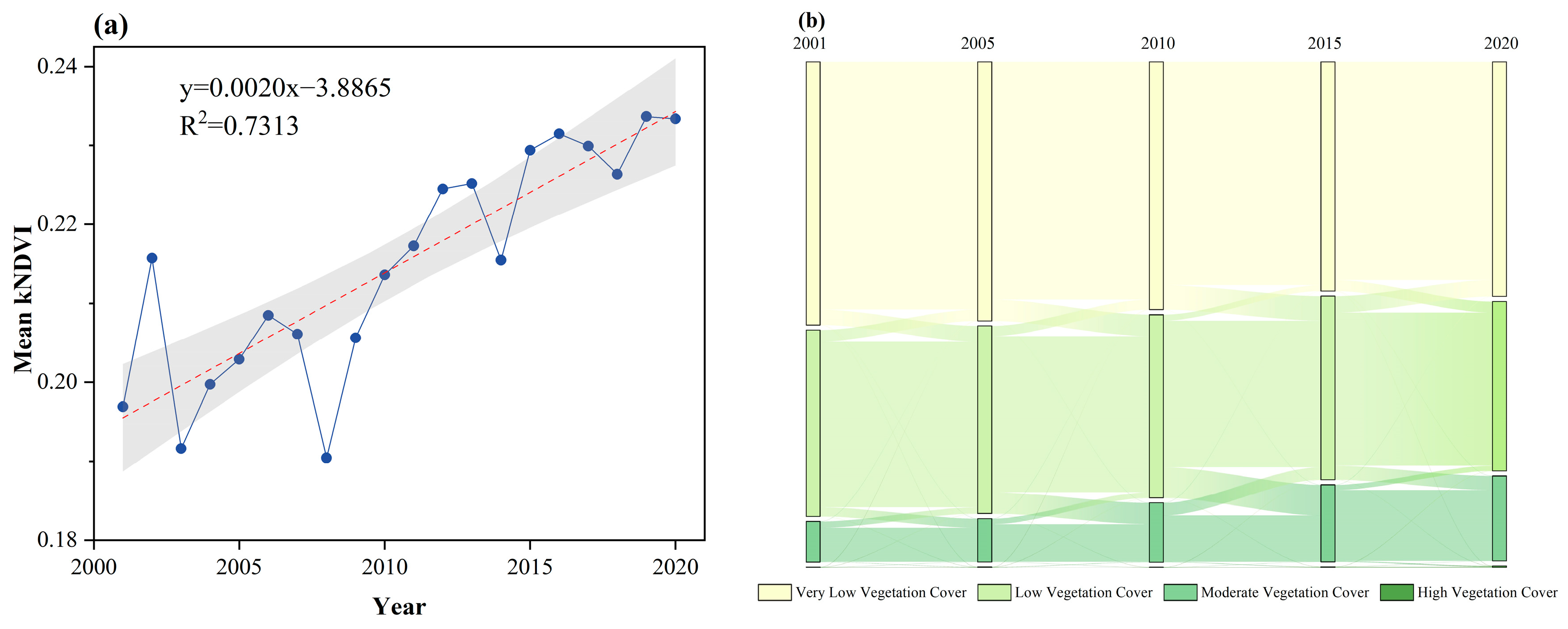
4.2. Spatio-Temporal Changes of Vegetation

The results presented in Figure 4a show a significant greening trend, with kNDVI increasing by 0.0361 over the study period at an annual rate of 0.002 (p < 0.05). From 2001 to 2008, vegetation growth exhibited a fluctuating decline, followed by a fluctuating increase from 2008 to 2020.
Vegetation cover dynamics for the years 2000, 2005, 2010, 2015, and 2020 are illustrated using a Sankey diagram (Figure 4b). The diagram demonstrates that China’s vegetation has undergone a stepwise transition from lower to higher vegetation cover levels. Specifically, areas with very low vegetation cover primarily transitioned into low vegetation cover, with outflow ratios of 99.99%, 99.98%, 99.92%, and 99.96% during the periods 2000–2005, 2005–2010, 2010–2015, and 2015–2020, respectively. The expansion of moderately vegetated areas was mainly due to the transformation from low vegetation cover, accounting for 97.5%, 98.1%, 99.71%, and 99.52% across the corresponding periods. While the total area changed only slightly, the internal dynamics within both low and high vegetation categories were pronounced.
To reveal the spatial patterns of vegetation change, the kNDVI trend and its statistical significance across China are presented in Figure 5a,b, respectively. The analysis reveals that 81.29% of vegetated regions exhibited a positive trend, indicating a dramatic greening pattern. Approximately 48.7% of the vegetated areas experienced a significant (p < 0.05) increasing trend in kNDVI, while only 2.4% showed a significant decrease in vegetation. Additionally, the vegetation with a negative kNDVI slope mostly degraded in a non-significant manner (p ≥ 0.05). Among the areas with significant increasing kNDVI, up to 1.51%, 34.04%, and 64.45% underwent a fast increasing rate (slope ≥ 0.01/a), a moderately increasing rate (0.005/a ≤ slope < 0.01/a) and a slightly increasing rate (slope < 0.005/a), respectively. As shown in Figure 5a, hotspots of significant greening are mainly distributed in the North China Plain and southern China, dominated by croplands and forests. Provinces in these areas, notably in southwestern China, such as Guangxi and Guizhou, showed a rapidly increasing rate of more than 0.012/a in some vegetated areas. The browning primarily displays a scattered distribution, closely related to the location of urban areas. It is noticed that significant vegetation decline occurred in the northern Greater Khingan, Hulunbuir, Inner Mongolia, covering such a contiguous area. This can be explained by the fact that long-term exposure to climate change (temperature rise, precipitation decreases) and human activities (overgrazing, cultivation, mining) have led to a reduction in the suitable habitat for coniferous forests and grassland degradation [39]. The associated significance test in Figure 5b reveals that approximately 51.1% of the vegetated areas indicate significant kNDVI dynamics (p < 0.05), while the remaining 48.9% reflect non-significant changes (p ≥ 0.05). These areas with non-significant changes are mainly located in the Tibetan Plateau and northwestern and northeastern China. Overall, China’s vegetation has experienced significant changes in the past two decades, dominated by greening in central and southern regions.

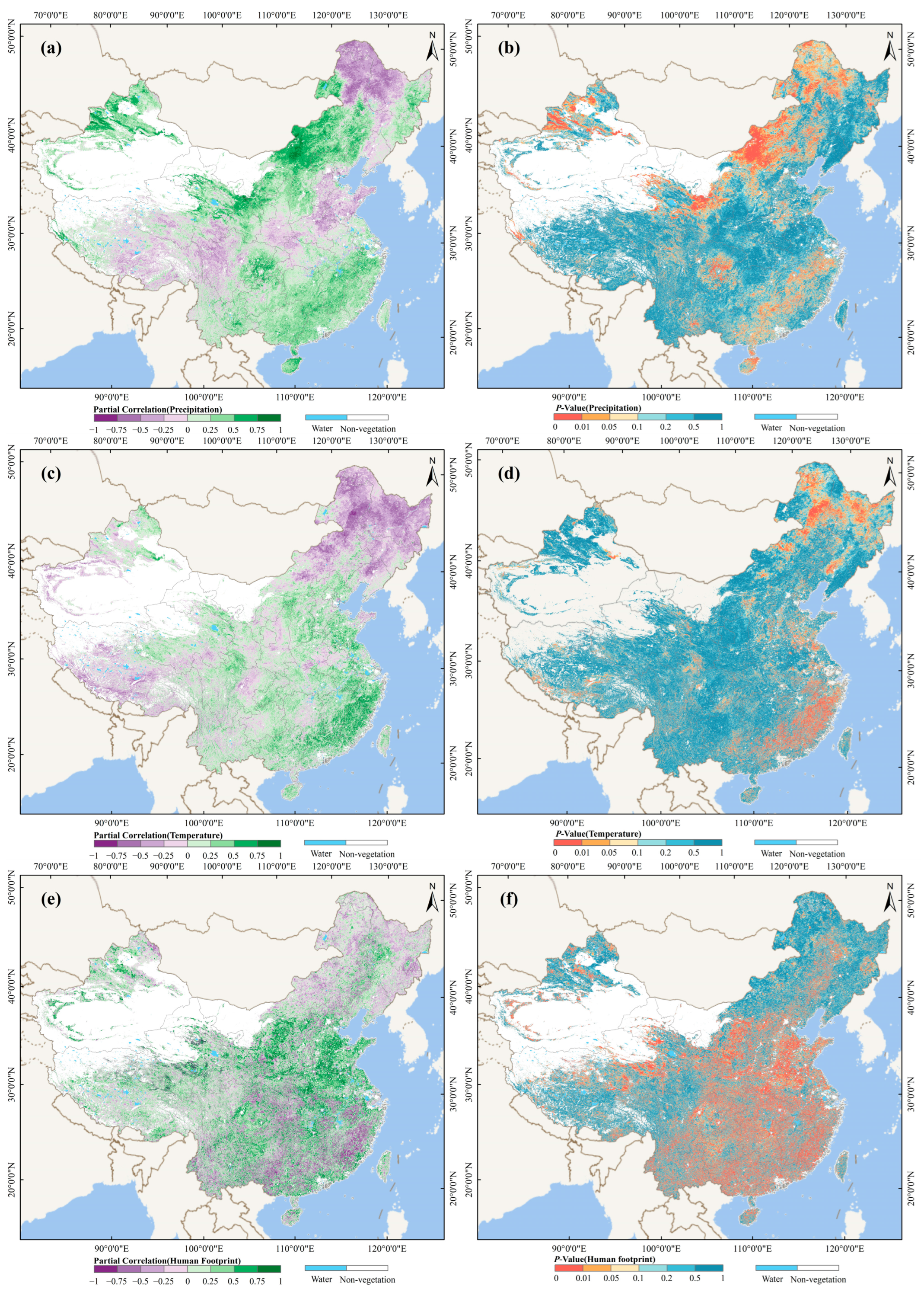
4.3. Correlation Between kNDVI and Climatic and Anthropogenic Factors

We conducted a partial correlation analysis to examine how kNDVI responds to precipitation, temperature, and human footprint. The spatial distributions of the partial correlation coefficients between kNDVI and these factors in China from 2001 to 2020, along with their statistical significance, are illustrated in Figure 6. Climate change is undeniably an important factor influencing vegetation variation. As shown in Figure 6a–d, both precipitation and temperature were generally positively correlated with kNDVI, with pixels showing positive correlations being more widespread than those with negative correlations. Statistically, the partial correlation coefficient between precipitation and kNDVI is 0.317 (p < 0.05), and that between temperature and kNDVI is 0.036 (p < 0.05). These correlations exhibit clear spatial heterogeneity, as depicted in Figure 6a–d. Precipitation plays a crucial role in vegetation growth, especially in arid and semi-arid regions such as the Mongolian Plateau, the Loess Plateau, and Northwest China (Figure 6a–b), where partial correlation coefficients exceed 0.75 (p < 0.05). In contrast, temperature shows a negative relationship with kNDVI in these regions. This may be explained by the fact that rising temperatures increase evaporation and drought stress, exacerbating vegetation degradation under conditions of water scarcity [40]. As mapped in Figure 6c,d, temperature significantly promotes vegetation growth in Southeast China (correlation coefficients > 0.75, p < 0.05), but suppresses it in Northeast China (correlation coefficients < –0.75, p < 0.05). This reason is that Southeast China is rich in precipitation resources; higher temperatures can promote photosynthesis and prolong the growing season, while in Northeast China, where moisture is a key limiting factor, rising temperatures can exacerbate surface evaporation, leading to soil water deficit and triggering water stress [41].
Compared with climatic factors, human activities have wider impacts on vegetation dynamics, with significantly larger areas showing strong correlations between human footprint and kNDVI (Figure 6e,f). Human activities have substantially promoted vegetation greening in regions such as the Loess Plateau, the North China Plain, and the middle and lower reaches of the Yangtze River Plain. This improvement may be attributed to initiatives such as the Grain-for-Green Program, agricultural intensification, and soil erosion control, which are widely recognized as key drivers of regional vegetation restoration. In contrast, significant negative correlations between the human footprint and kNDVI are observed in some economically developed areas such as central and southern China, likely due to ecological degradation associated with rapid industrialization [42]. Overall, the positive correlation between kNDVI and the human footprint is much stronger and more widespread than that with climatic factors. This underscores the dominant role of human activities in shaping vegetation dynamics and highlights the spatial heterogeneity of their impacts.
To provide a comparative perspective on the driving factors of vegetation dynamics, a stacked bar chart is presented in Figure 7, illustrating the correlations between precipitation, temperature, and human footprint with kNDVI. Overall, both climatic drivers (precipitation and temperature) and human activities exhibit a positive correlation with kNDVI across most vegetated areas. Among them, precipitation shows the most extensive positive correlation with vegetation growth, with over 65% of vegetated areas displaying a positive correlation between precipitation and kNDVI, followed by human footprint (59%) and temperature (51%). The associated confidence test indicates that the correlations between precipitation, temperature, and human footprint with kNDVI are mostly non-significant. The positive correlation between precipitation and kNDVI only accounts for 14.73% (p < 0.05), and in 4.43% of areas, the precipitation is significantly negatively correlated to kNDVI. Temperature also shows a predominant non-significant correlation, with 6.74% and 6.25% of vegetated areas exhibiting significant positive and negative correlations, respectively. The areas showing significant positive (19.32%) and negative (9.97%) correlations between kNDVI and human footprint are the largest, reflecting the dominant role of human activities in driving vegetation changes. Ecological protection initiatives have significantly fostered vegetation growth, while rapid economic development and urbanization have hindered it.

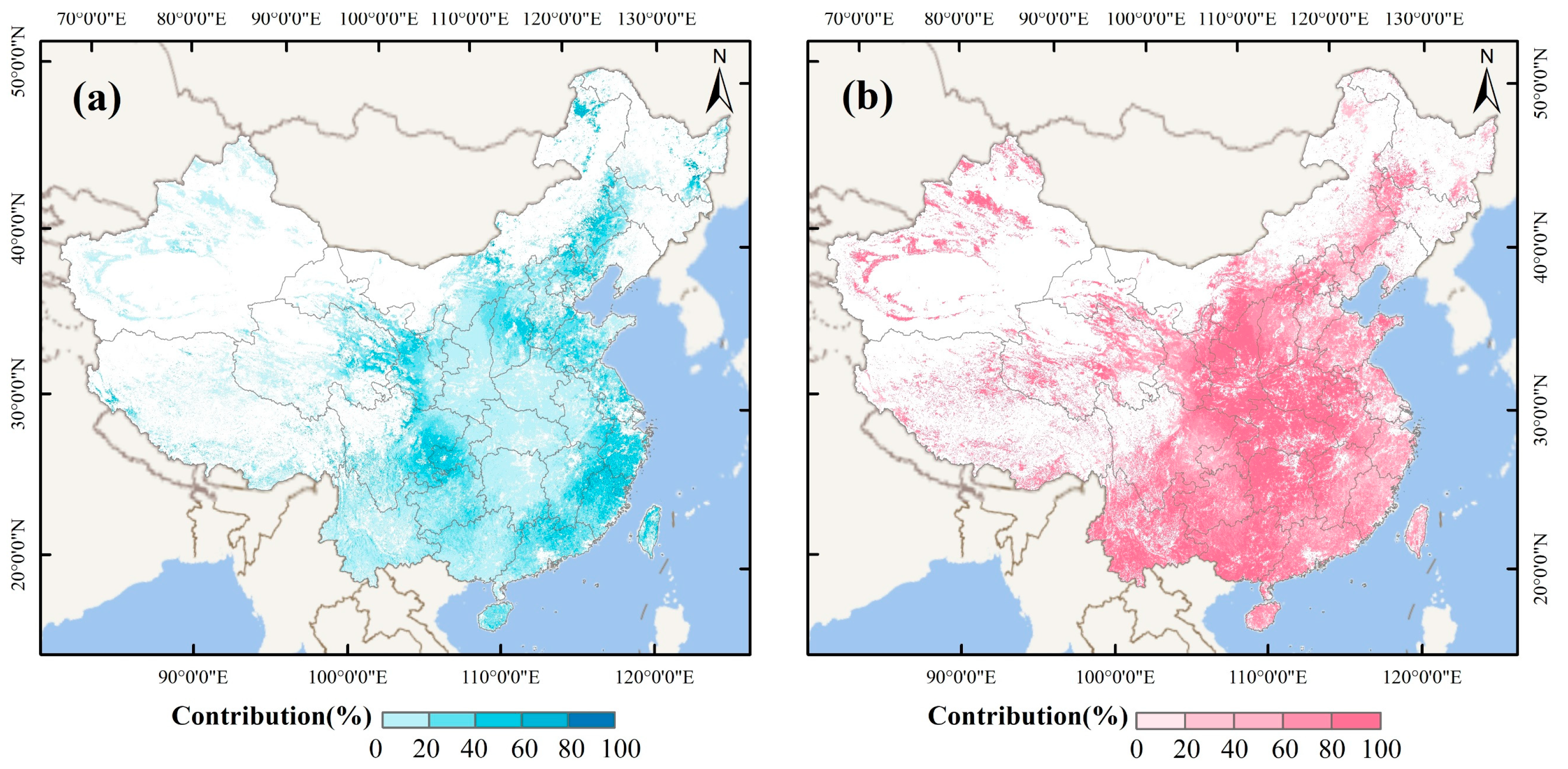
4.4. Relative Contribution of Climate Change and Human Activities to Vegetation Dynamics

In this study, we separated and quantified the impacts of climatic and anthropogenic drivers on vegetation change using the residual trend analysis method. The relative contributions of climate change and human activities to vegetation dynamics across China are illustrated in Figure 8, which highlights the spatial heterogeneity of the dominant driving forces. Overall, climate change and human activities accounted for 21.89% and 78.11% of significant vegetation changes, respectively, indicating the dominant role of human activities. Over the past two decades, vegetation in China has responded quite differently to climate change and human activities. In general, climate change contributed far less to vegetation growth, with more than 50% of affected areas showing a contribution rate of less than 20% (Figure 8a). The influence of climate factors was relatively higher in the Sichuan Basin and eastern coastal regions, where contribution rates of 40–60% were observed in 13.44% of significantly changed vegetated areas. Regions with contribution rates exceeding 60% were much smaller in extent, accounting for only 2.6%, and were mainly distributed in southeastern coastal areas and the northern Greater Khingan Mountains.
Compared with climate change, vegetation variations were more strongly influenced by human activities, with over 90% of the areas more affected by anthropogenic factors. As shown in Figure 8b, most regions exhibit a high relative contribution from human activities, with 51.10% of the areas showing contribution rates above 80% and 32.85% falling within the 60–80% range. These highly human-influenced regions are mainly located in the Loess Plateau, central China, and the Yunnan–Guizhou Plateau. In contrast, areas with contribution rates below 40% are rarely observed. Based on the relative contribution analysis, it can be concluded that human activities have generally exerted a greater influence on vegetation dynamics than climate change, particularly in central China.
For a more intuitive comparison of vegetation responses to climate change and human activities, the kNDVI trend was superimposed with the relative contribution rates. The contributions of climate change and human activities were further analyzed in relation to significant greening and browning. In addition, to determine the main driver of vegetation dynamics, the relative contribution rates greater than 60% were regarded as the dominant factor, and the rates within 40–60% were defined as the combined climate and human driver. Accordingly, the study area was divided into six categories, as shown in Figure 9a. The spatial distribution of dominant climate and human effects exhibits notable heterogeneity. Among regions experiencing significant greening, 66.42% were primarily driven by human activities, mainly concentrated in the Loess Plateau, central China, and southwestern China. Joint impacts of climate and human factors accounted for 28.44%, especially in the eastern coastal regions and the Sichuan Basin, whereas only 0.74% of greening was mainly attributed to climate change alone. However, only 4.4% of significantly changed vegetation showed a degradation trend, of which 0.15%, 2.72%, and 1.53% were dominated by climate change, human activities, and their combined effects, respectively. In conclusion, human activities are the dominant driver of both vegetation improvement and degradation across China from 2001 to 2020.
To further assess the potential impacts of climate change and human activities on vegetation dynamics, relative contribution rates were also analyzed by vegetation type. The contributions of climate change and human activities to both greening and browning across different vegetation cover types are presented in Figure 9b. Among all six types, vegetation was largely improved and mostly attributed to human activities, particularly in shrublands, with more than 99% of the area showing an increase mainly induced by anthropogenic activities. However, vegetation variations mainly induced by climate change always accounted for the smallest proportion for both greening and browning, as low as less than 1% for each vegetation type. These results indicate that human activities have dominantly driven vegetation variation (especially greening) under diverse plant types in China, with the greatest proportion of pixels where vegetation increase was mainly attributed to human activities.

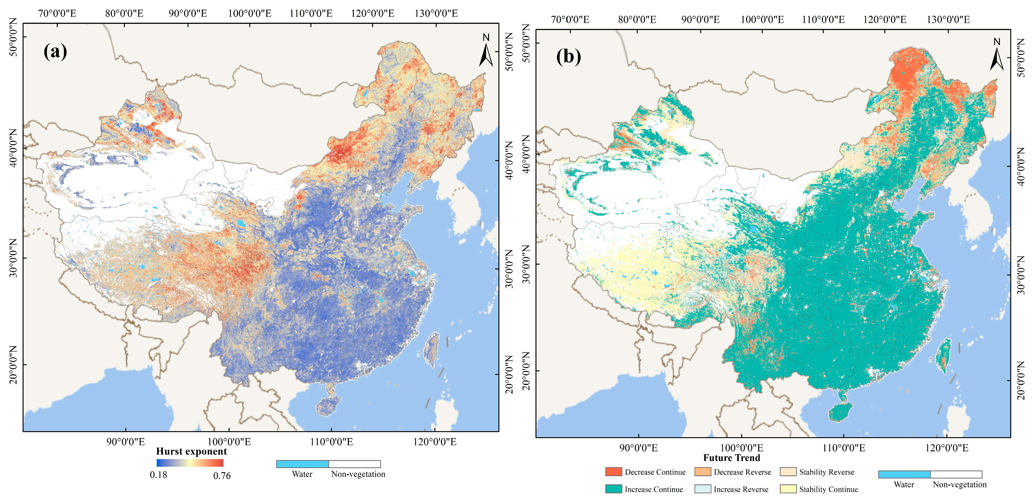
4.5. Future Trends in Vegetation Coverage

To project future trends in vegetation coverage across China, the Hurst exponent was employed to assess the long-term persistence of kNDVI changes. The results are illustrated in Figure 10. As shown in Figure 10a, the Hurst exponent of kNDVI from 2001 to 2020 ranged from 0.18 to 0.76, with an average H value of 0.604, indicating that the future trends in vegetation coverage will largely be characterized by persistence. The spatial distribution of the Hurst exponent reveals a clear north-to-south decreasing pattern. Persistent areas (H > 0.5) and anti-persistent areas (H < 0.5) accounted for 85.93% and 14.07% of vegetated regions, respectively, while pixels with no discernible trend (H = 0.5) were rare. These results provide strong evidence suggesting that future vegetation changes will mostly follow a persistent trend, consistent with the past features from 2001 to 2020.
Furthermore, we coupled the past kNDVI change from 2001 to 2020 and the Hurst trend to predict the future tendency of vegetation coverage in China. The spatial distribution of future trends is presented in Figure 10b. The results demonstrate that the future change in vegetation in China is mostly consistent with the past trend; more than 85% of vegetated areas will continue the previous change pattern, especially the greening trend. Among these persistent regions, areas of continued increase account for 61.28%, mainly located in the Northeast Plain, North China Plain, Loess Plateau, and central and southern China. Few sites exhibit a persistent decreasing trend, accounting for only 8.24%, which are primarily located in Northeast China (like Greater Khingan) and scattered in the east of the Tibetan Plateau and urban areas. In contrast, the pixels displaying an anti-persistent trend are rarely observed, with only 3.59% changing from increasing in the past to decreasing in the future, and 2.60% showing a transition from decreasing to increasing. Persistent stability in kNDVI covers approximately 16.44%, predominantly in the Tibetan Plateau, while 7.85% of vegetated regions will reverse from stability to change, mainly distributed in the Inner Mongolia Plateau, Tibetan Plateau, and Northwest China. Based on these results, we can conclude that vegetation in China will mostly continue to increase in the future.

5. Discussion

5.1. Changes in Forests and Driving Force

The results of the residual trend analysis indicate that China has experienced significant greening, with hotspots of rapid increase primarily observed in forest and cropland areas. Moreover, the greening of forests and croplands was predominantly driven by human activities. To further explore the dynamics in forests and croplands and their response to anthropogenic factors, we focused on the forests and croplands to analyze associated human activities. Focusing first on forests in China, the interannual trend of forest kNDVI from 2001 to 2020 closely corresponds with the trend in tree cover fraction (Figure 11c). Overall, both annual kNDVI and tree cover fraction show a clear upward trend, suggesting substantial improvements in forest coverage and vegetation density over the study period. The increase in tree cover highlights the impact of ecological restoration programs such as the Grain-for-Green Program, afforestation initiatives, and the Natural Forest Protection Program. Numerous previous studies have also reported substantial greening in China, primarily attributed to the implementation of large-scale ecological projects [43], which aligns with the findings of this study.
Besides the temporal analysis, the spatial distributions of kNDVI trends and changes in tree cover fraction were also examined, as presented in Figure 11. As shown in Figure 11a, the tree cover fraction in most forested regions of China shows an increasing trend from 2001 to 2020, consistent with the findings of Chi Chen et al. [16]. Over the past few decades, China has strengthened forest resource protection and restoration through a series of policy measures [44]. For instance, the implementation of the Grain-for-Green policy and large-scale afforestation projects has contributed to the recovery of degraded ecosystems, thereby improving regional vegetation cover. The spatial trend of kNDVI also closely matches that of tree cover fraction, indicating an overall enhancement in forest conditions. The consistency between kNDVI growth and increased tree cover fraction further confirms the pivotal role of human activities in driving forest greening.

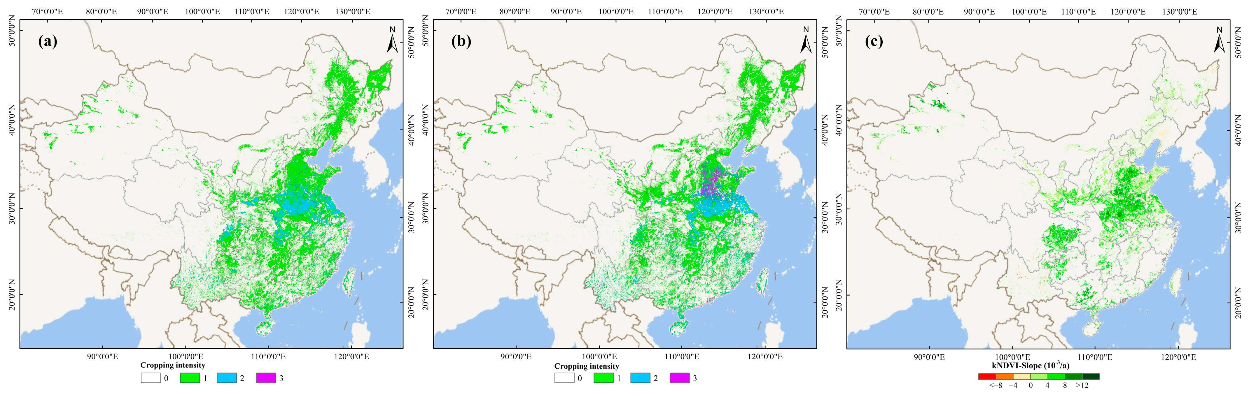
5.2. Changes in Croplands and Driving Force

Our results demonstrate that most croplands have undergone significant improvement over the past two decades, making a substantial contribution to China’s overall greening. Additionally, human activities are identified as the primary drivers. To further investigate cropland dynamics and the influence of anthropogenic activities, we analyzed changes in cropping intensity and its association with kNDVI trends (Figure 12). The cropping intensity of agricultural land in 2001 and 2019 is illustrated in Figure 12a,b, respectively. This index reflects the frequency of crop cultivation within a year, thereby indicating the intensity of agricultural activity. A clear increase in cropping intensity is observed in the middle and lower reaches of the Yangtze River and the North China Plain. This trend closely aligns with the cropland greening pattern shown in Figure 12c, suggesting a positive correlation between agricultural intensification and vegetation improvement in these areas. Nearly all cropland areas exhibit a greening trend in kNDVI, particularly in agriculturally intensive regions such as the middle and lower Yangtze River basin and the North China Plain. This is largely attributed to increased harvested area through multiple cropping. Agricultural intensification in China has been supported by enhanced irrigation systems, increased fertilizer application, advanced agricultural technologies, and optimized cropping structures. By comparing cropping intensity with kNDVI trends in croplands, it becomes evident that human activities have played an increasingly important role in driving vegetation changes—especially through cropland expansion and intensified agricultural practices.

5.3. Limitations of the Current Study

While this study provides a comprehensive assessment of vegetation dynamics and their driving factors across China using kNDVI and residual trend analysis, several limitations remain that may affect the robustness and generalizability of the findings. The residual trend method relies on a core assumption: that vegetation changes predicted solely from climate variables—primarily temperature and precipitation—adequately capture the climate-driven component of vegetation variation. Any residuals are therefore attributed to human activities. Although this analytical separation is convenient, it oversimplifies the complex and often interwoven relationships between climate and anthropogenic influences [45]. In reality, human land-use practices such as irrigation, afforestation, and crop selection are often shaped by climatic variability. These indirect, climate-mediated human responses may lead to attribution errors, particularly in regions where socio-environmental interactions are pronounced. Another important limitation is that the predicted kNDVI is a theoretical construct rather than a directly observed variable. Its accuracy depends entirely on the structure of the prediction model and the completeness of the climate variables used. Important environmental drivers such as solar radiation, soil moisture, wind, and extreme weather events, which can significantly influence vegetation, were not included due to data limitations [46]. The omission of these factors may lead to an underestimation of the climate-vegetation relationship and result in the misattribution of some climate-driven effects to human activities.
Additionally, the accuracy and resolution of auxiliary datasets may also influence attribution results. Although the MODIS surface reflectance data used to generate kNDVI are corrected by the MAIAC algorithm, residual atmospheric noise and geometric distortions may persist, especially in topographically complex or cloud-prone regions. Furthermore, while the human footprint dataset is comprehensive, it aggregates diverse anthropogenic activities into a single index and does not differentiate between beneficial interventions (e.g., ecological restoration) and detrimental impacts (e.g., urban expansion or deforestation). Finally, the necessary spatial resampling of multi-source datasets to a uniform resolution may introduce additional uncertainties, particularly in ecologically heterogeneous transitional zones.
To address some of these limitations, we have conducted preliminary validation of the kNDVI predictions using available protected area data, comparing model results with observed vegetation changes. However, this validation remains preliminary, and more comprehensive validation using additional reserves, different climate drivers, and higher-quality data will be pursued in future work.

6. Conclusions

The main objective of this study is to quantitatively assess the spatiotemporal dynamics of vegetation in China and to disentangle the relative contributions of climate change and human activities to vegetation change. Using kNDVI as an indicator of vegetation variation, we analyzed pixel-based changes across China and projected future trends based on Theil-Sen slope estimation, partial correlation analysis, and the Hurst exponent. Residual trend analysis was applied to distinguish the climatic and anthropogenic impacts on vegetation dynamics. On this basis, we further investigated vegetation changes and their driving forces in forests and croplands.
China has experienced substantial vegetation improvement over the past two decades, with a statistically significant average increase of 0.002 per year (p < 0.05). Among all vegetated areas, 81.29% exhibited an increasing trend. Specifically, pixels with significant greening accounted for 48.7%, while those with significant browning made up only 2.4%. The most pronounced greening was observed in central and southern China, whereas degradation mainly occurred in the Greater Khingan region and scattered urban areas. Future projections suggest that the greening trend will persist, with 61.28% of areas expected to continue increasing and only 8.24% showing continuous decline.
Both climate change and human activities have contributed to vegetation dynamics. Partial correlation analysis reveals that, compared to climatic factors, human activities have a broader and stronger influence, with significantly larger areas showing a strong correlation between kNDVI and human footprint. Residual trend analysis indicates that 66.42% of significant greening was primarily driven by human activities, particularly in the Loess Plateau, central, and southwestern China. Overall, human activities contributed 78.11% to vegetation changes, while climate change accounted for only 21.89%, confirming that anthropogenic factors are the dominant drivers. In forest and cropland ecosystems, vegetation greening has largely benefited from reforestation programs and agricultural intensification.

Author Contributions

Conceptualization, X.C. and Y.C.; methodology, Z.T.; formal analysis, T.B.; investigation, Z.S.; writing—original draft preparation, X.C. and Z.T.; writing—review and editing, Y.C. and K.S.; supervision, Y.C. All authors have read and agreed to the published version of the manuscript.

Funding

This research was funded by the National Natural Science Foundation of China (Grant No. 42301457) and the Natural Science Foundation of Hubei Province (Grant No. 2022CFB447 and 2025AFB061).

Data Availability Statement

All the experimental data can be downloaded through the link provided in the paper.

Conflicts of Interest

The authors declare no conflicts of interest.

References

  1. Sun, Y.L.; Shan, M.; Pei, X.R.; Zhang, X.K.; Yang, Y.L. Assessment of the impacts of climate change and human activities on vegetation cover change in the Haihe River basin, China. Phys. Chem. Earth 2020, 115, 102834. [Google Scholar] [CrossRef]
  2. Zhang, H.; Hu, Z.; Chen, X.; Li, J.; Zhang, Q.; Zheng, X. Global greening mainly contributed by climate change at more than twice the historical rate during the 21st century. Glob. Change Biol. 2025, 31, e70126. [Google Scholar] [CrossRef] [PubMed]
  3. Qi, G.; Cong, N.; Luo, M.; Qiu, T.; Rong, L.; Ren, P.; Xiao, J. Contribution of climatic change and human activities to vegetation dynamics over Southwest China during 2000–2020. Remote Sens. 2024, 16, 3361. [Google Scholar] [CrossRef]
  4. Zhang, Y.; Lu, Y.; Song, X. Identifying the main factors influencing significant global vegetation changes. Forests 2023, 14, 1607. [Google Scholar] [CrossRef]
  5. Yan, Z.; Ding, Y.; Zhai, P.; Song, L.; Cao, L.; Li, Z. Re-assessing climatic warming in China since 1900. J. Meteorol. Res. 2020, 34, 243–251. [Google Scholar] [CrossRef]
  6. Liu, H.; Liu, F.; Yuan, H.; Zheng, L.; Zhang, Y. Assessing the relative role of climate and human activities on vegetation cover changes in the up–down stream of Danjiangkou, China. J. Plant Ecol. 2022, 15, 180–195. [Google Scholar] [CrossRef]
  7. Gao, X.; Huang, X.; Lo, K.; Dang, Q.; Wen, R. Vegetation responses to climate change in the Qilian Mountain nature reserve, Northwest China. Glob. Ecol. Conserv. 2021, 28, e01698. [Google Scholar] [CrossRef]
  8. Chen, Q.; Niu, B.; Hu, Y.; Luo, T.; Zhang, G. Warming and increased precipitation indirectly affect the composition and turnover of labile-fraction soil organic matter by directly affecting vegetation and microorganisms. Sci. Total Environ. 2020, 714, 136787. [Google Scholar] [CrossRef] [PubMed]
  9. Zhang, X.; Li, X. An innovative index for separating the effects of temperature and precipitation on global vegetation change. iScience 2023, 26, 106972. [Google Scholar] [CrossRef] [PubMed]
  10. Zhang, Q.; Yang, J.; Wang, W.; Ma, P.; Lu, G.; Liu, X.; Yu, H.; Fang, F. Climatic warming and humidification in the arid region of Northwest China: Multi-scale characteristics and impacts on ecological vegetation. J. Meteorol. Res. 2021, 35, 113–127. [Google Scholar] [CrossRef]
  11. Gao, C.; Ren, X.; Fan, L.; He, H.; Zhang, L.; Zhang, X.; Li, Y.; Zeng, N.; Chen, X. Assessing the vegetation dynamics and its influencing factors in Central Asia from 2001 to 2020. Remote Sens. 2023, 15, 4670. [Google Scholar] [CrossRef]
  12. Wu, Q.; Jiang, X.; Song, M.; Liu, Y.; Shi, X.; Lei, Y.; Nie, T. Study on the development trend of social-ecological systems and the drivers of sustainable development—A case study of the Loess Plateau in China. Ecol. Indic. 2023, 156, 111172. [Google Scholar] [CrossRef]
  13. Ma, S.; Deng, G.; Wang, L.-J.; Hu, H.; Fang, X.; Jiang, J. Telecoupling between urban expansion and forest ecosystem service loss through cultivated land displacement: A case study of Zhejiang Province, China. J. Environ. Manag. 2024, 357, 120695. [Google Scholar] [CrossRef] [PubMed]
  14. Yu, F.J.; Yan, L. Trends in urban vegetation growth in China from 2000 to 2022. Land 2024, 13, 1015. [Google Scholar] [CrossRef]
  15. Tian, Q.; Lu, J.; Chen, X. A novel comprehensive agricultural drought index reflecting time lag of soil moisture to meteorology: A case study in the Yangtze River basin. Catena 2022, 209, 105804. [Google Scholar] [CrossRef]
  16. Chen, C.; Park, T.; Wang, X.; Piao, S.; Xu, B.; Chaturvedi, R.K.; Fuchs, R.; Brovkin, V.; Ciais, P.; Fensholt, R.; et al. China and India lead in greening of the world through land-use management. Nat. Sustain. 2019, 2, 122–129. [Google Scholar] [CrossRef] [PubMed]
  17. Guo, B.; Wei, C.; Yu, Y.; Liu, Y.; Li, J.; Meng, C.; Cai, Y. The dominant influencing factors of desertification changes in the source region of Yellow River: Climate change or human activity? Sci. Total Environ. 2022, 813, 152512. [Google Scholar] [CrossRef] [PubMed]
  18. Huang, S.; Tang, L.; Hupy, J.P.; Wang, Y.; Shao, G. A commentary review on the use of normalized difference vegetation index (NDVI) in the era of popular remote sensing. J. For. Res. 2021, 32, 1–6. [Google Scholar] [CrossRef]
  19. Li, Z.; Yin, C.; Tan, Z.; Liu, X.; Li, S.; Ma, X.; Zhang, X. Landslide susceptibility assessment considering time-varying of dynamic factors. Nat. Hazards Rev. 2024, 25, 05024004. [Google Scholar] [CrossRef]
  20. Tesfaye, A.A.; Awoke, B.G. Evaluation of the saturation property of vegetation indices derived from Sentinel-2 in mixed crop-forest ecosystem. Spat. Inf. Res. 2021, 29, 109–121. [Google Scholar] [CrossRef]
  21. Camps-Valls, G.; Campos-Taberner, M.; Moreno-Martínez, Á.; Walther, S.; Duveiller, G.; Cescatti, A.; Mahecha, M.D.; Muñoz-Marí, J.; García-Haro, F.J.; Guanter, L.; et al. A unified vegetation index for quantifying the terrestrial biosphere. Sci. Adv. 2021, 7, eabc7447. [Google Scholar] [CrossRef] [PubMed]
  22. Rojo-Álvarez, J.L.; Martínez-Ramón, M.; Muñoz-Marí, J.; Camps-Valls, G. Digital Signal Processing with Kernel Methods; Wiley: Hoboken, NJ, USA, 2018; pp. i–xxvi. [Google Scholar]
  23. Wang, Q.; Moreno-Martínez, Á.; Muñoz-Marí, J.; Campos-Taberner, M.; Camps-Valls, G. Estimation of vegetation traits with kernel NDVI. ISPRS J. Photogramm. Remote Sens. 2023, 195, 408–417. [Google Scholar] [CrossRef]
  24. Gu, Z.; Chen, X.; Ruan, W.; Zheng, M.; Gen, K.; Li, X.; Deng, H.; Chen, Y.; Liu, M. Quantifying the direct and indirect effects of terrain, climate and human activity on the spatial pattern of kNDVI-based vegetation growth: A case study from the Minjiang River Basin, Southeast China. Ecol. Inform. 2024, 80, 102493. [Google Scholar] [CrossRef]
  25. Shen, M.; Wang, S.; Jiang, N.; Sun, J.; Cao, R.; Ling, X.; Fang, B.; Zhang, L.; Zhang, L.; Xu, X.; et al. Plant phenology changes and drivers on the Qinghai–Tibetan Plateau. Nat. Rev. Earth Environ. 2022, 3, 633–651. [Google Scholar] [CrossRef]
  26. Niu, Z.; He, H.; Yu, P.; Sitch, S.; Zhao, Y.; Wang, Y.; Jain, A.K.; Vuichard, N.; Si, B. Climate change and CO2 fertilization have played important roles in the recent decadal vegetation greening trend on the Chinese Loess Plateau. Remote Sens. 2023, 15, 1233. [Google Scholar] [CrossRef]
  27. He, C.; Yan, F.; Wang, Y.; Lu, Q. Spatiotemporal variation in vegetation growth status and its response to climate in the Three-River Headwaters Region, China. Remote Sens. 2022, 14, 5041. [Google Scholar] [CrossRef]
  28. Feng, X.; Tian, J.; Wang, Y.; Wu, J.; Liu, J.; Ya, Q.; Li, Z. Spatiotemporal variation and climatic driving factors of vegetation coverage in the Yellow River Basin from 2001 to 2020 based on kNDVI. Forests 2023, 14, 620. [Google Scholar] [CrossRef]
  29. Wang, J.; Xiao, H.; Hartmann, R.; Yue, Y. Physical Geography of China and the U.S.; Springer: Dordrecht, The Netherlands, 2014. [Google Scholar]
  30. Pandit, J.; Sharma, A.K. A comprehensive review of climate change’s imprint on ecosystems. J. Water Clim. Change 2023, 14, 4273–4284. [Google Scholar] [CrossRef]
  31. Peng, S.; Ding, Y.; Liu, W.; Li, Z. 1 km monthly temperature and precipitation dataset for China from 1901 to 2017. Earth Syst. Sci. Data 2019, 11, 1931–1946. [Google Scholar] [CrossRef]
  32. Mu, H.; Li, X.; Wen, Y.; Huang, J.; Du, P.; Su, W.; Miao, S.; Geng, M. A global record of annual terrestrial Human Footprint dataset from 2000 to 2018. Sci. Data 2022, 9, 176. [Google Scholar] [CrossRef] [PubMed]
  33. Li, P.; Wang, J.; Liu, M.; Xue, Z.; Bagherzadeh, A.; Liu, M. Spatio-temporal variation characteristics of NDVI and its response to climate on the Loess Plateau from 1985 to 2015. Catena 2021, 203, 105331. [Google Scholar] [CrossRef]
  34. Chen, T.; Xia, J.; Zou, L. Quantifying the influences of natural factors and human activities on NDVI change in the Hanjing River Basin, China. Remote Sens. 2020, 12, 3780. [Google Scholar] [CrossRef]
  35. Huang, Y.; Jiang, N.; Shen, M.; Guo, L. Effect of preseason diurnal temperature range on the start of vegetation growing season in the Northern Hemisphere. Ecol. Indic. 2020, 112, 106161. [Google Scholar] [CrossRef]
  36. Evans, J.; Geerken, R. Discrimination between climate and human-induced dryland degradation. J. Arid Environ. 2004, 57, 535–554. [Google Scholar] [CrossRef]
  37. Bashir, B.; Cao, C.; Naeem, S.; Joharestani, M.Z.; Bo, X.; Afzal, H.; Jamal, K.; Mumtaz, F. Spatio-temporal vegetation dynamic and persistence under climatic and anthropogenic factors. Remote Sens. 2020, 12, 2612. [Google Scholar] [CrossRef]
  38. Li, C.; Jia, X.; Zhu, R.; Mei, X.; Wang, D.; Zhang, X. Seasonal spatiotemporal changes in the NDVI and its driving forces in Wuliangsu Lake Basin, Northern China from 1990 to 2020. Remote Sens. 2023, 15, 2965. [Google Scholar] [CrossRef]
  39. Tong, S.; Bao, G.; Bao, Y.; Huang, X. Monitoring of long-term vegetation dynamics and responses to droughts of various timescales in Inner Mongolia. Ecosphere 2023, 14, e4415. [Google Scholar] [CrossRef]
  40. Yang, Q.; Jiang, C.; Ding, T. Impacts of extreme-high-temperature events on vegetation in North China. Remote Sens. 2023, 15, 4542. [Google Scholar] [CrossRef]
  41. Chen, Y.; Ma, L.; Liu, T.; Huang, X.; Sun, G. The synergistic effect between precipitation and temperature for the NDVI in Northern China from 2000 to 2018. Appl. Sci. 2023, 13, 8425. [Google Scholar] [CrossRef]
  42. Chen, L.; Li, C.; Pan, C.; Yan, Y.; Jiao, J.; Zhou, Y.; Wang, X.; Zhou, G. Estimating the effects of natural and anthropogenic activities on vegetation cover: Analysis of Zhejiang Province, China, from 2000 to 2022. Remote Sens. 2025, 17, 1433. [Google Scholar] [CrossRef]
  43. Song, W.; Feng, Y.; Wang, Z. Ecological restoration programs dominate vegetation greening in China. Sci. Total Environ. 2022, 848, 157729. [Google Scholar] [CrossRef] [PubMed]
  44. Huang, A.; Shen, R.; Jia, G.; Xu, X. Reforestation enhanced landscape connectivity for thermal buffering in China. Environ. Res. Lett. 2022, 17, 014056. [Google Scholar] [CrossRef]
  45. Wu, J.; Li, M.; Zhang, X.; Fiedler, S.; Gao, Q.; Zhou, Y.; Cao, W.; Hassan, W.; Mărgărint, M.C.; Tarolli, P.; et al. Disentangling climatic and anthropogenic contributions to nonlinear dynamics of alpine grassland productivity on the Qinghai–Tibetan Plateau. J. Environ. Manag. 2021, 281, 111875. [Google Scholar] [CrossRef] [PubMed]
  46. Zhao, F.; Wang, X.; Wu, Y.; Sivakumar, B.; Liu, S. Enhanced dependence of China’s vegetation activity on soil moisture under drier climate conditions. J. Geophys. Res. Biogeosci. 2023, 128, e2022JG007300. [Google Scholar] [CrossRef]
Figure 1. The study area of China. (a) Geographic location and elevation; (b) land cover types in 2020.
Remotesensing 17 02446 g001
Figure 2. Flow charts showing the steps of the present study.
Remotesensing 17 02446 g002
Figure 3. Validation of the kNDVIpre in the Hoh Xil National Nature Reserve. (a) Spatial distribution of bias between kNDVIobs and kNDVIpre in 2002. (b) Pixel-wise scatterplot between kNDVIobs and kNDVIpre values.
Remotesensing 17 02446 g003
Figure 4. Spatial and temporal dynamics of vegetation in China from 2001 to 2020. (a) Interannual trend of kNDVI in China from 2001 to 2020. (b) Sankey diagram for vegetation cover dynamics in China from the years 2000, 2005, 2010, 2015, and 2020.
Remotesensing 17 02446 g004
Figure 5. Spatiotemporal dynamics of kNDVI in China from 2001 to 2020. (a) the interannual trends in kNDVI; (b) the associated statistical significance.
Remotesensing 17 02446 g005
Figure 6. Spatial distribution of the partial correlation coefficients between kNDVI and precipitation (a), temperature (c), and human footprint (e) from 2001 to 2020, as well as the associated statistical significance for relationships between kNDVI and precipitation (b), temperature (d), and human footprint (f).
Remotesensing 17 02446 g006
Figure 7. The stacked bar chart statistically analyzes the correlation between precipitation, temperature, and human footprint with kNDVI.
Remotesensing 17 02446 g007
Figure 8. Spatial distribution of the relative contributions of climatic change (a) and human activities (b) to vegetation dynamics in China from 2001 to 2020.
Remotesensing 17 02446 g008
Figure 9. Dominant drivers of vegetation dynamics and their contributions across vegetation types in China from 2001 to 2020. (a) Spatial distribution of the dominant driver of vegetation dynamics in China from 2001 to 2020. (b) The contributions of climate change and human activities to vegetation dynamics over different vegetation types in China. The acronyms G and B refer to Greening and Browning, respectively. CC and HA represent climate change and human activities, respectively. Forests, shrublands, savannas, grasslands, wetlands, and croplands are denoted by the acronyms FOR, SHR, SVA, GRA, WET, and CRO.
Remotesensing 17 02446 g009
Figure 10. Spatial distribution of Hurst exponent (a) and future trends in vegetation coverage (b).
Remotesensing 17 02446 g010
Figure 11. Spatial and temporal trends in forest greening across China from 2001 to 2020. Spatial distribution of trends in tree cover fraction (a) and kNDVI (b) of forests in China from 2001 to 2020. Interannual trend in kNDVI and tree cover fraction of forests in China from 2001 to 2020 (c).
Remotesensing 17 02446 g011
Figure 12. Spatial distribution of cropping intensity and kNDVI slope in agricultural lands: (a) cropping intensity in 2001; (b) cropping intensity in 2019; (c) trend in kNDVI of croplands.
Remotesensing 17 02446 g012
Table 1. Description of the dataset used in this study.
Data NameSpatial ResolutionTemporal
Period
Source
Surface Reflectance500 m2001–now
(Daily)
Terra + Aqua MODIS Land Surface
Bidirectional Reflectance Factor (BRF) (https://lpdaac.usgs.gov/products/mcd19a1v061/)
(accessed on 12 July 2025)
Temperature1 km1901–2023
(Monthly)
National Earth System Science Data
Center (http://www.geodata.cn)
(accessed on 12 July 2025)
precipitation1 km1901–2023
(Monthly)
National Earth System Science Data
Center (http://www.geodata.cn)
(accessed on 12 July 2025)
Land Cover500 m2001–now
(Yearly)
Terra + Aqua MODIS Land Cover (https://lpdaac.usgs.gov/products/mcd12q1v061/)
(accessed on 12 July 2025)
Human Footprint 1 km2000–2020
(Yearly)
Human Footprint data (https://www.x-mol.com/groups/li_xuecao/news/48145)
(accessed on 12 July 2025)
Cropping Intensity250 m2001–2019
(Yearly)
Global Cropping Intensity data (https://data.apps.fao.org/)
(accessed on 12 July 2025)
Tree cover fraction250 m2000–2020
(Yearly)
Terra MODIS VCF Vegetation Continuous Fields (VCF) (https://lpdaac.usgs.gov/products/mod44bv061/)
(accessed on 12 July 2025)
Table 2. The scenarios for assessing relative contributions of climate change and human activities to vegetation dynamics S l o p e ( k N D V I o b s ) , S l o p e ( k N D V I p r e ) , and S l o p e ( k N D V I r e s ) represent the slope of k N D V I o b s , k N D V I p r e , and k N D V I r e s , respectively.
k N D V I o b s TrendScenariosRelative Contributions
k N D V I p r e Trend k N D V I r e s TrendClimateHuman
Increasing change>0>0 S l o p e ( k N D V I p r e ) S l o p e ( k N D V I o b s ) S l o p e ( k N D V I r e s ) S l o p e ( k N D V I o b s )
>0<01000
<0>00100
Decreasing change<0<0 S l o p e ( k N D V I p r e ) S l o p e ( k N D V I o b s ) S l o p e ( k N D V I r e s ) S l o p e ( k N D V I o b s )
<0>01000
>0<00100
Table 3. Accuracy assessment of kNDVIpre in nature reserves using pixel-wise statistics.
Nature ReserveRMSEBiasR2Pearson’s r
Hoh Xil National Nature Reserve0.004−5.53 × 10−110.9010.949
Three river sources0.016−3.43 × 10−100.8730.934
Altun Mountains, Xinjiang0.0072.26 × 10−100.8500.922
Selincuo Wetland0.0055.12 × 10−120.9450.972
Yarlung Zangbo River, Tibet0.007−4.97 × 10−110.9380.968
Disclaimer/Publisher’s Note: The statements, opinions and data contained in all publications are solely those of the individual author(s) and contributor(s) and not of MDPI and/or the editor(s). MDPI and/or the editor(s) disclaim responsibility for any injury to people or property resulting from any ideas, methods, instructions or products referred to in the content.

