Article

Remote Sensing Archaeology of the Xixia Imperial Tombs: Analyzing Burial Landscapes and Geomantic Layouts

1
School of Marine Technology and Geomatics, Jiangsu Ocean University, Lianyungang 222005, China
2
Zhongwang (Nanjing) Information Technology Co., Ltd., Nanjing 210042, China
3
School of Geomatics and Urban Spatial Informatics, Beijing University of Civil Engineering and Architecture, Beijing 102616, China
4
School of Surveying and Urban Spatial Information, Henan University of Urban Construction, Pingdingshan 467036, China
5
Aerospace Information Research Institute, Chinese Academy of Sciences, Beijing 100094, China
*
Author to whom correspondence should be addressed.
Remote Sens. 2025, 17(14), 2395; https://doi.org/10.3390/rs17142395
Submission received: 11 May 2025 / Revised: 7 July 2025 / Accepted: 8 July 2025 / Published: 11 July 2025

Abstract

The Xixia Imperial Tombs (XITs) represent a crucial, yet still largely mysterious, component of the Tangut civilization’s legacy. Located in northwestern China, this extensive necropolis offers invaluable insights into the Tangut state, culture, and burial practices. This study employs an integrated approach utilizing multi-resolution and multi-temporal satellite remote sensing data, including Gaofen-2 (GF-2), Landsat-8 OLI, declassified GAMBIT imagery, and Google Earth, combined with deep learning techniques, to conduct a comprehensive archaeological investigation of the XITs’ burial landscape. We performed geomorphological analysis of the surrounding environment and automated identification and mapping of burial mounds and mausoleum features using YOLOv5, complemented by manual interpretation of very-high-resolution (VHR) satellite imagery. Spectral indices and image fusion techniques were applied to enhance the detection of archaeological features. Our findings demonstrated the efficacy of this combined methodology for archaeology prospect, providing valuable insights into the spatial layout, geomantic considerations, and preservation status of the XITs. Notably, the analysis of declassified GAMBIT imagery facilitated the identification of a suspected true location for the ninth imperial tomb (M9), a significant contribution to understanding Xixia history through remote sensing archaeology. This research provides a replicable framework for the detection and preservation of archaeological sites using readily available satellite data, underscoring the power of advanced remote sensing and machine learning in heritage studies.

1. Introduction

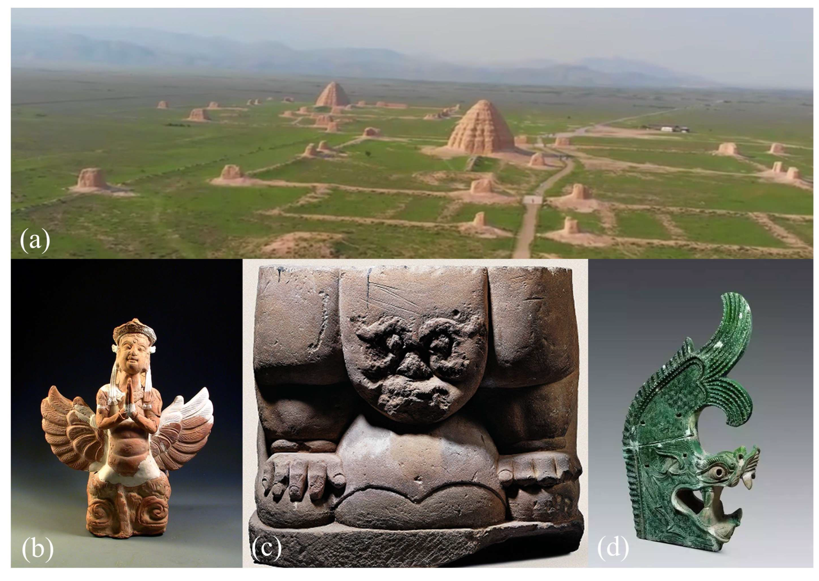
1.1. Archaeological and Historical Backgrounds

The Xixia (1038–1227 A.D.), or Western Xia, exerted significant influence over a vast territory in modern-day northwestern China for nearly two centuries [1,2,3,4]. Controlling vital segments of the ancient Silk Road, the Tanguts facilitated crucial connections between China, Central Asia, and Mongolia, contributing significantly to regional trade and cultural exchange [5,6,7]. Their civilization, a blend of Chinese, Mongolian, and Western influences, flourished in an agricultural-husbandry region, leaving a rich, albeit partially lost, legacy in various domains, including philosophy, literature, military strategy, art, politics, music, religion, and architecture [8,9]. The tripartite confrontation among the Xixia, Liao (916–1125 A.D.), and Northern and Southern Song (960–1279 A.D.) dynasties shaped the political landscape of medieval China [10,11,12,13,14]. The destruction of their capital, Xingqing (modern-day Yinchuan), by the Mongols in 1227 A.D. led to the loss of much of their historical records and architectural heritage. However, 20th-century archaeological endeavors, particularly Pyotr Kozlov’s discoveries at Ancient Khara-Khoto, brought renewed attention to the Tangut civilization and their unique script, laying the groundwork for subsequent research [15].
Imperial tombs worldwide, such as the Egyptian Pyramids and the Mausoleum of the First Qin Emperor, serve as crucial sources for understanding ancient civilizations. In ancient China, the construction of imperial necropolises, often near the capital and guided by geomantic principles, was paramount for legitimizing rule, ensuring eternal life, and reinforcing the connection between the divine and the imperial authority [16,17]. These sites were intricately designed, incorporating elements of theology, astronomy, mathematics, geography, and ethnology to symbolize the emperor’s enduring power [18,19,20,21,22]. The Xixia Imperial Tombs (XITs), located at the southeastern margins of Helan Mountain, constitute a remarkable necropolis of over 250 unexcavated tombs (Figure 1), including those of the Xixia emperors and their families. These tombs are a vital source of historical, cultural, and archaeological evidence concerning the rise and fall of the Tangut civilization. Their study, particularly through the lens of geomancy, is essential for unraveling Tangut achievements in astronomy and philosophy and gaining deeper insights into their civilization.

1.2. Optical Satellite Remote Sensing in Archaeology

Remote sensing has emerged as a cost-effective, efficient, and powerful tool for archaeological surveying, mapping, and documentation across various scales. The application of optical imaging, encompassing historical aerial photography [23,24,25,26,27], multi- and hyper-spectral data [27,28,29,30,31,32], synthetic aperture radar (SAR) [33,34,35], and LiDAR [36,37,38,39], has become increasingly prevalent in archaeological studies. Significant advancements in radiometric, spatial, temporal, and spectral resolution of satellite sensors over the past six decades, from early CORONA spy satellite imagery to modern very-high-resolution (VHR) systems, like IKONOS and Gaofen, have revolutionized archaeological research methods [40,41,42,43]. High-resolution (HR) and VHR optical satellite imagery (spatial resolution ≤ 10 m and ≤2 m, respectively) have been widely adopted in archaeology for feature extraction, landscape analysis, digital reconstruction, detection of illicit activities, damage assessment, and heritage management [44]. Declassified data from programs like CORONA and GAMBIT, as well as imagery from commercial satellites, including GeoEye, IKONOS, QuickBird, and WorldView, and more recent systems like Sentinel-2 and Gaofen-1/2, have been instrumental in these applications [45,46]. While manual interpretation and computer-assisted methods have been traditionally employed for extracting archaeological features from VHR data, historical imagery is particularly valuable in landscapes transformed by human activities like agriculture and urbanization [47]. The higher spatial resolution of GAMBIT offers advantages over CORONA in certain contexts [48,49,50,51], and free or low-cost VHR data from systems like GF-2 provide competitive alternatives.

1.3. Archaeological Remote Sensing for the Burial Landscape
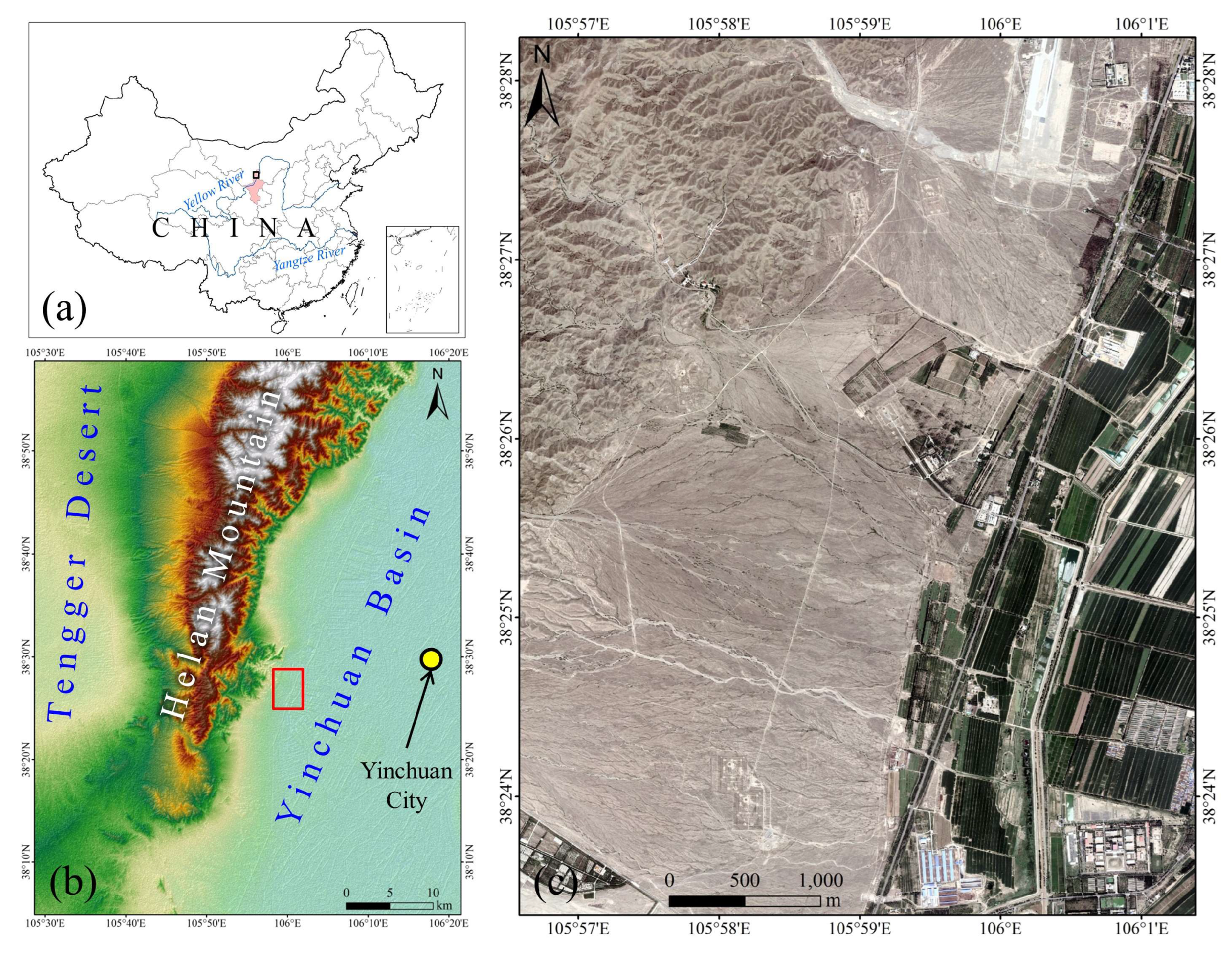
Optical satellite remote sensing has proven invaluable for detecting, extracting, mapping, and documenting archaeological features, especially at the landscape scale. However, a comprehensive understanding of complex burial landscapes necessitates integrating remote sensing with knowledge of topography, geomorphology, geography, eco-environmental conditions, and the historical, social, cultural, and economic aspects of the landscape [52,53]. Remote sensing has been successfully applied to the study of notable burial landscapes globally, including the Pyramids of Egypt, the Mausoleum of the First Qin Emperor, the Taj Mahal, and the Imperial Tombs of the Ming and Qing Dynasties [54,55,56,57,58,59,60]. Examples include the use of aerial thermal infrared and multispectral remote sensing at the Mausoleum of the First Qin Emperor, mapping of buried features, and exploration of geomantic practices through satellite imagery [54,55]. Despite these advancements, most studies have focused primarily on morphological features, lacking in-depth analysis of the cultural and geomantic meanings embedded within burial landscapes. Traditional Tangut archaeology, for instance, has relied more on historical texts than on remote sensing techniques. This study addresses this gap by employing VHR optical satellite data to extract, map, and analyze the burial landscapes of the XITs. While geomantic studies in China have largely concentrated on the imperial mausoleums of central dynasties, less attention has been given to minority regimes like the Xixia. Remote sensing offers a novel perspective for understanding burial landscapes, particularly concerning spatial layout and tomb orientation. This research aims to explore the potential influences of both Tangut and Chinese geomantic practices on the configuration of the XITs. The following sections detail the study area and data (Section 2), methodology (Section 3), results and discussion (Section 4), and conclusions (Section 5).

2. Study Area

2.1. Ancient Xingqing

This study focuses on the historical region of Xingqing, presently known as Yinchuan City in the Ningxia Hui Autonomous Region, China (Figure 2), an area with well-documented history predating and postdating the Xixia Dynasty. Initially established as Fuping County in the late 3rd century B.C., it was later renamed Huaiyuan in the 6th century A.D. Following the collapse of the Tang Dynasty in 907 A.D., the Tangut Xixia Empire designated this region as its capital, triggering a substantial migration of the local population. Throughout the imperial era, Ancient Xingqing evolved into a strategically vital military stronghold in northwestern China. Situated along the Yellow River and protected by the Helan Mountains to the west, it was strategically positioned at the eastern extremity of the Hexi Corridor and the western edge of the Hetao Plain. This location facilitated its crucial role in trade, cultural exchange, and communication networks along the Silk Road routes leading to the Mongolian Plateau, Loess Plateau, and the Western Regions.

2.2. The Archaeological Areas of the Xixia Imperial Tombs (XITs)

The XITs, recognized as one of ancient China’s largest and most significant royal necropolises, have attracted increasing scholarly attention. They provide crucial insights into the history of the Xixia Dynasty and are considered a prime representation of the remarkable Tangut civilization. The XITs are inscribed on the Tentative Lists of the World Cultural Heritage Site. Often referred to as the “Oriental Pyramids” (Figure 1a), the XITs served as the imperial necropolis for the emperors of the Xixia Dynasty. They were meticulously planned and constructed along the southeastern slopes of the Helan Mountains and the western bank of the Yellow River, approximately 25 km west of Ancient Xingqing (Figure 2). While early 20th-century explorers like Aurel Stein, Pyotr Kozlov, and Sven Hedin made significant discoveries in Central Asia and China, including Ancient Loulan, Mogao Grottoes, and Ancient Khara-Khoto, the Xixia capital and its imperial tombs remained undiscovered by them. The first documentation of the XITs came in the 1930s through an aerial photograph captured by Wulf-Dieter Graf zu Castell, published in his 1938 book, Chinaflug [61]. Following the establishment of the People’s Republic of China, these tombs were initially misidentified as belonging to the Tang Dynasty (618–907 A.D.) until the 1970s. Accidental discoveries of pottery and stone bricks with Tangut scripts during airstrip construction in 1972 prompted comprehensive surveys and excavations by Chinese archaeologists from 1972 to 1975, gradually revealing the significance of the XITs to the world.
Despite extensive research and excavation, the ownership of the nine imperial tombs within the XITs remains a subject of ongoing debate. Constructed between the 11th and 13th centuries, the XITs are situated in a landscape that transitions from the Helan Mountains in the west to the Yinchuan Plain and the Yellow River in the east. The mausoleums are aligned along the eastern slopes of the Helan Mountains, forming a distinctive ribbon-like complex stretching from north to south. Located on broad alluvial fans at the base of the mountains, the tombs embody the unique historical and ethnic character of the Xixia Dynasty. The site’s impressive architectural features include tiered sacred walls, monumental tomb mounds, and various associated mausoleum structures (Figure 1b–d). Excavated funerary artifacts and cultural relics, such as pottery, inscriptions, stone statues, and architectural components, exhibit vivid forms, unique decorations, and reflections of a nomadic lifestyle. Furthermore, the presence of wall paintings, Buddhist sculptures and frescos, stone and brick carvings, and architectural elements underscores the close cultural connections between the Tangut civilization and the traditional cultures of ancient China, Central Asia, and Mongolia. The XITs are currently the most well-preserved archaeological monuments representing the grandeur of the Tangut civilization at its highest societal level. They stand as a significant testament to the existence of the long-lost Tangut civilization, highlighting its remarkable adaptability and rich cultural diversity.

3. Data and Methods

3.1. Optical Satellite Remote Sensing Data and Preprocessing

This study utilized a variety of optical satellite remote sensing datasets to investigate the geological structures, geomorphological and hydrological features, and alluvial deposit-masked tombs within the XITs area. The datasets included imagery from Landsat-5, Landsat-8, China’s Gaofen-2, the declassified GAMBIT Spy Satellite (Keyhole-7), and Google Earth.
To address the complex spatial, spectral, and historical characteristics of the XITs, we employed a data integration strategy combining multi-temporal, multi-resolution, and multi-type satellite imagery. Each dataset contributes unique advantages: GAMBIT for historical perspectives, GF-2 for high spatial resolution, Landsat for spectral indices and landscape-scale trends, and Google Earth for deep learning input. This fusion allowed cross-validation of features, enhanced detection accuracy, and comprehensive archaeological analysis from micro- to macro-scale.

3.1.1. Declassified GAMBIT Spy Satellite Photographs

The GAMBIT (KH-7) reconnaissance satellite system, operated by the United States from July 1963 to June 1967, acquired imagery with initial ground resolutions of 1.2 m, improving to 0.6 m by 1966. Thirty out of thirty-eight missions successfully yielded usable imagery. While most GAMBIT imagery was declassified in 2002, specific program details remained classified until 2011. An image from Mission No. 4016, acquired on 12 March 1965, was used in this study. Geometrical correction was performed using simulated ground control points obtained with handheld GNSS devices (CHCNAV LT60H, Shanghai, China), achieving sub-pixel horizontal accuracy. Preprocessing in ENVI 5.4 software included histogram equalization and the enhanced Lee filter (5 × 5 window) to enhance image clarity.

3.1.2. Gaofen Satellite Imagery

Imagery from China’s Gaofen-2 (GF-2) optical satellite (Table 1), China’s first civilian satellite with sub-meter resolution (0.8 m panchromatic and 3.2 m multispectral), was incorporated. Acquired on 29 April 2015, the GF-2 data were obtained from the China Centre for Resource Satellite Data and Applications. GF-2, part of a high-resolution constellation with GF-1, 6, and 7, supports various applications, including mapping, resource surveys, environmental monitoring, disaster observation, and agricultural assessment. Preprocessing involved radiometric and atmospheric corrections to minimize noise and enhance spectral analysis capabilities for archaeological feature detection. Orthorectification using rational polynomial coefficients (RPCs) and further geometrical correction with simulated ground control points (handheld GNSS) ensured spatial accuracy. All GF-2 data preprocessing was conducted using ENVI 5.4. Visual interpretation of the 0.8 m resolution GF-2 imagery allowed for clear observation of archaeological features at the XIT site, including linear sacred walls and circular tomb mounds, identifiable by distinct edges and soil/shadow marks.

3.1.3. Landsat-5 TM and Landsat-8 OLI Data

Landsat-5 (LS-5) Thematic Mapper (TM) and Landsat-8 (LS-8) Operational Land Imager (OLI) data, both with a 30 m spatial resolution, were used for analyzing the geological features of the study area. These USGS-operated optical sensors provide data on terrain composition. Four scenes were processed using ENVI 5.4, including two LS-5 TM images and one LS-8 OLI image, acquired on 17 October 2013 and 17 October 2015, respectively. Each Landsat scene covers approximately 185 km × 185 km. Data standardization was achieved using the top-of-atmosphere (TOA) method, and the enhanced Lee filter (3 × 3 window) was applied. The combination of visible and infrared (IR) bands aided in differentiating land surface features for geological analysis.

3.1.4. Google Earth VHR Imagery

Google Earth (GE) provides access to VHR imagery from various commercial satellites (2000–present), with resolutions up to approximately 0.4 m depending on the location’s significance. The free version, GE Pro (v7.3.6), was used, providing access to 1 m IKONOS images (2003) and 0.4 m WorldView images (2021), offering multi-temporal coverage. Specific images, including a QuickBird image (5 April 2005), three WorldView images (2 October 2020), and a GeoEye image (25 March 2020), were clipped and saved at a “premium resolution” of 4800 dpi. It is important to note that GE VHR images are RGB renderings lacking original digital numbers (DNs) and the near-infrared (NIR) band, and their spatial resolution is reduced. While not suitable for quantitative remote sensing, these images are highly valuable for visual interpretation and archaeological object recognition. Five GE image clips were geo-referenced in ArcGIS 10.3 using 0.8 m GF-2 orthorectified imagery as a reference, resulting in minimal root mean square error (RMSE).

3.1.5. Digital Elevation Model (DEM)

Digital elevation data from the Shuttle Radar Topography Mission (SRTM) were employed for landscape archaeology and geospatial analysis of the XITs. SRTM, the first spaceborne single-pass synthetic aperture radar (SAR) interferometer mission, generated a near-global DEM using C-band radar interferometry. The C-band’s short wavelength (5.6 cm) allows penetration of vegetation, clouds, and dry sand. During its 11-day mission in February 2000, SRTM imaged most of the Earth’s surface between 60°N and 56°S. Since September 2014, SRTM data with a 1 arc-second (30 m) posting have been available for latitudes below 50°.

3.2. Data Fusion

Data fusion and image merging techniques were utilized to enhance the visibility of archaeological surface features in optical satellite data. Gram–Schmidt pansharpening was applied to combine the VHR panchromatic (PAN) images with the high spectral resolution multispectral (MS) images from GF-2 PMS and Landsat-8 OLI. This technique was chosen to minimize spectral distortion. Data fusion allowed integrating different spectral channels, such as visible and infrared data, to create color composites that revealed both physical and geometric properties of the target surface. The merged images improved visual clarity and highlighted geomorphic and structural features, particularly aiding in the identification of buried or destroyed small tombs within the XITs. Although image fusion was not applied directly to the deep learning (DL) training due to spectral and format constraints, it significantly supported the visual interpretation of burial landscapes and informed the post-DL validation process.

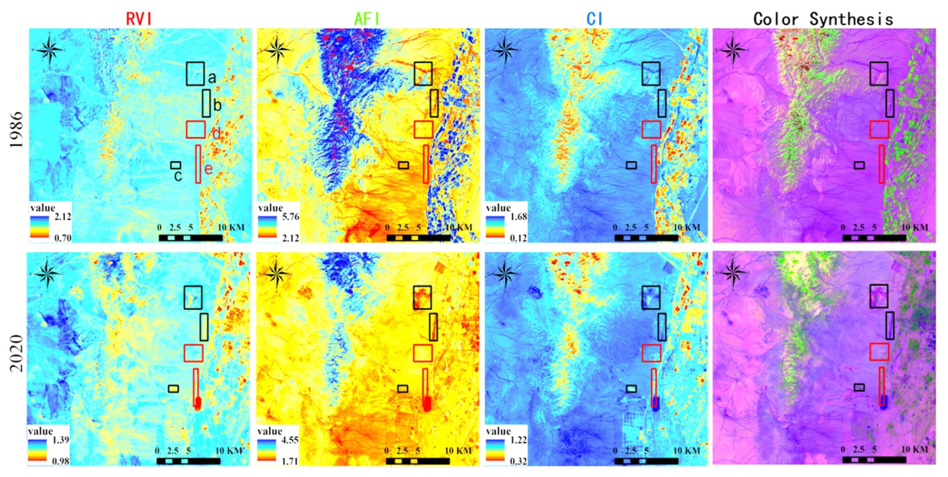
3.3. Spectral Indices

Spectral indices (SIs) are mathematical combinations of reflectance values from multiple spectral bands designed to emphasize specific features of interest while minimizing external effects. Several band-ratio-based indices derived from Landsat-8 OLI and Landsat-5 TM data were selected for their relevance to the study’s objectives. The Relative Vegetation Index (RVI = Band 4/Band 3 for Landsat-8) was used to indicate vegetation density and health. The Alluvial Fan Index (AFI = Band 6/Band 2 for Landsat-8) served as a significant indicator of alluvial fan formations. The Clay Index (CI = (Band 6/Band 7)/(Band 5/Band 4) for Landsat-8) was applied to enhance the detection of clay minerals. Normalized reflectance images from Landsat-8 OLI were used to derive three multispectral combinations (Table 2), and two RGB false-color composites, including the Helan Mountain Alluvial Fan Index (HALF: = R   G   B = 4 3 6 2 6 7 / 5 4 ), were generated to improve visualization of rectangular features, highlight reflectance regions, and reveal shallow depressions.

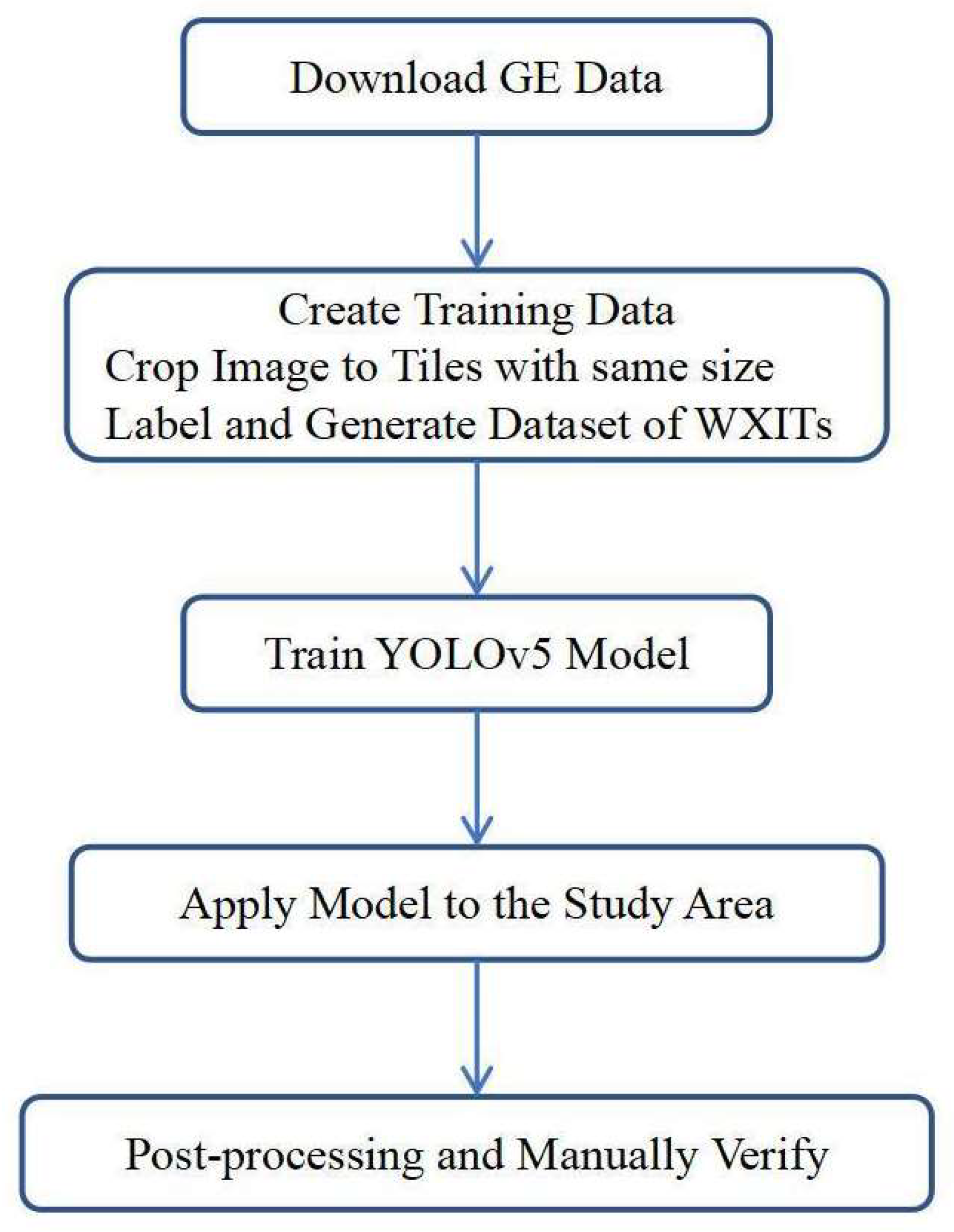
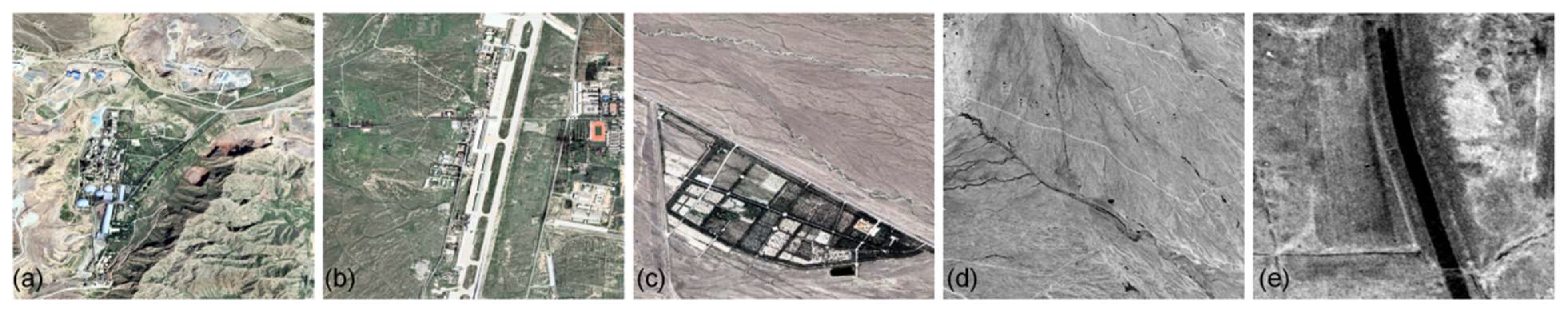
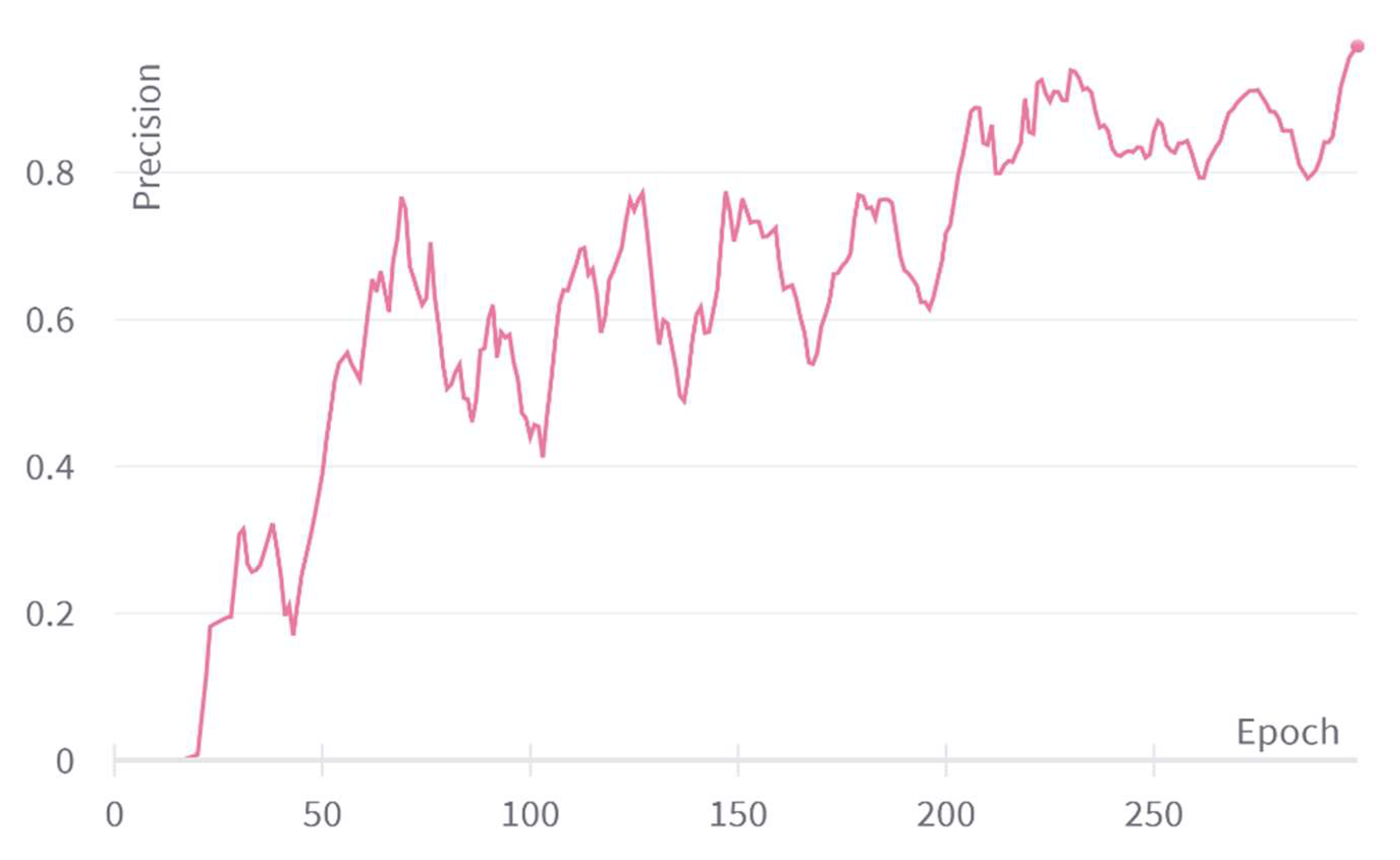
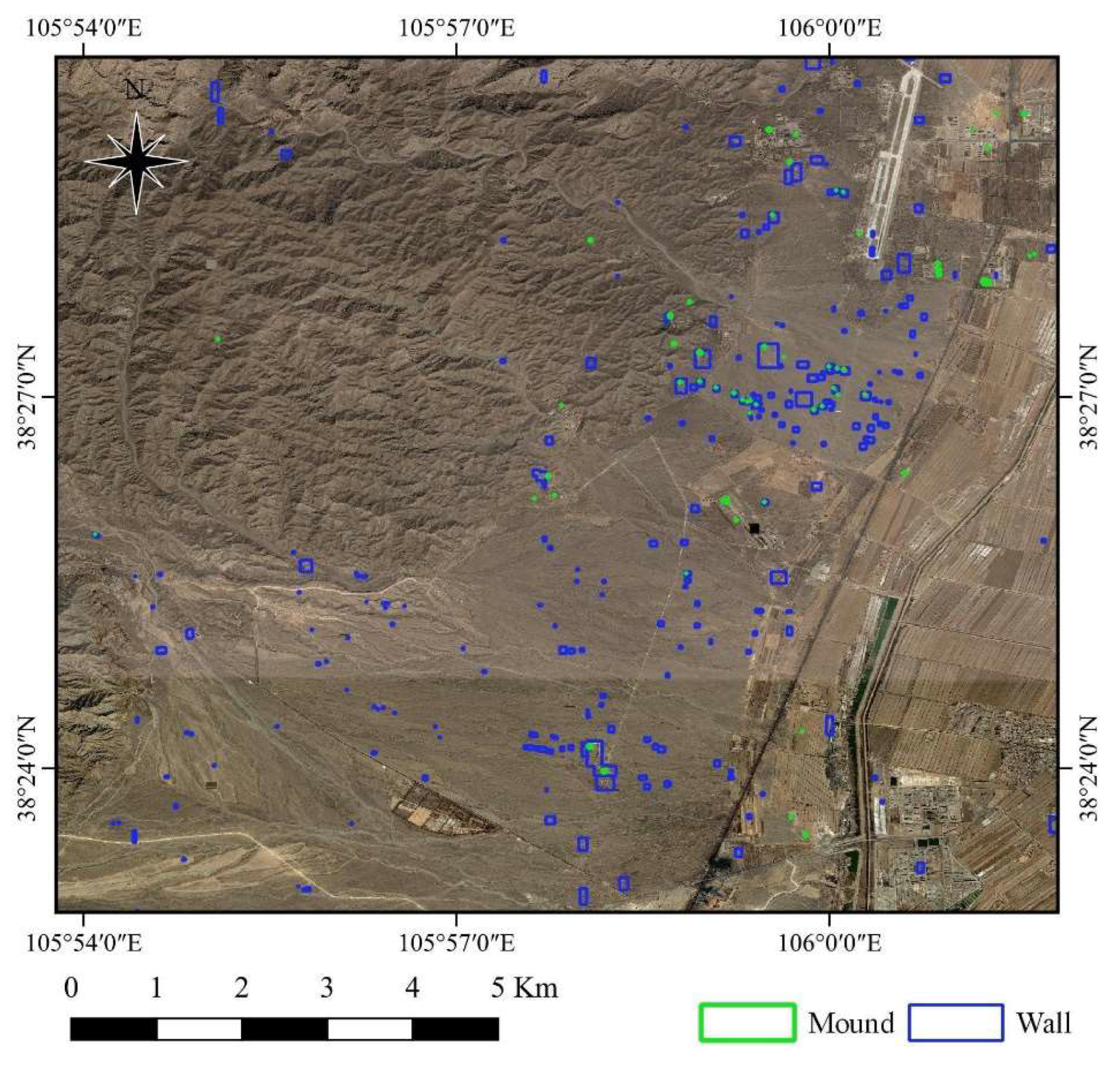
3.4. Automated Identification of the XITs and Their Subordinate Tombs

This study adopted a dual-path workflow: YOLOv5 was trained exclusively on consistent-format GE imagery for automatic detection, while GAMBIT and GF-2 imagery were used for expert validation and correction, ensuring reliability of results, particularly in poorly preserved or visually ambiguous zones.
Automated identification of the XITs and their subordinate tombs was performed using deep learning applied to VHR GE imagery. DL, as an emerging computer vision technology, offers advantages in processing remote sensing images for recognizing thematic information and archaeological objects. In this study, YOLOv5 [64], a typical target detection model, was employed for identifying XITs. The workflow involved data enhancement strategies (scaling, cropping, and stitching) to enrich the training dataset and improve small target detection (Figure 3). During training, the network iteratively updated parameters by comparing prediction frames with ground-truth data. The process included obtaining 0.4 m resolution GE data, generating a training set through manual annotation and cropping, training the YOLOv5 model, and applying the trained model for image recognition. Post-processing and manual validation were performed to generate the final identification results.
Two categories, “wall” for sacred walls and “mound” for tomb mounds, were used for creating the training dataset. The classification into “wall” (sacred walls) and “mound” (tomb mounds) was based on geometric and spectral characteristics observed in VHR imagery. The sacred walls are usually linear or rectangular, while tomb mounds are circular or elliptical. This separation improved detection performance during YOLOv5 training. This separation enhanced the training efficiency and recognition accuracy of the YOLOv5 model by reducing intra-class variability.
The YOLOv5 model was trained for 300 epochs with a batch size of 8. The precision curve showed rapid accuracy improvement around 50 epochs, stabilizing near 0.9 after about 200 epochs. The YOLOv5 model reached a stabilized precision near 0.9 after 200 epochs, indicating convergence and robust feature learning. This suggests that the model effectively captured the shape and contextual clues associated with burial features, which is critical for automatic identification in visually complex environments. This threshold ensures that the model can effectively detect burial features across variable background conditions.

4. Results and Discussion

4.1. Remote Sensing Interpretation of the Supporting Environment of the XITs

To analyze the changes in the environment surrounding the XITs, a sensitivity analysis was conducted using the Helan Mountain Alluvial Fan Index (HALF) on areas featuring modern buildings and ancient sites. Analyzed modern areas included the Taomengou mining area, Helan Mountain airport, and a modern cemetery. Ancient sites examined were part of the XITs and ancient river channels (Figure 4). Figure 5 illustrates the changes observed. In the Taomengou mining area (Figure 4a), the Relative Vegetation Index (RVI) decreased while the Alluvial Fan Index (AFI) and Clay Index (CI) increased between 1986 and 2020, reflecting extensive mining activities.
The color composite image showed a transition from yellow to green. The Helan Mountain Airport area (Figure 4b), built before 1986, exhibited low RVI and high AFI and CI in 1986, appearing distinctly blue in the color composite. These characteristics became more pronounced by 2020, with the area appearing dark blue. In the modern cemetery area (Figure 4c), no distinct features were present in the 1986 color composite, and the natural alluvial fan topography was visible. By 2020, human activities had altered the alluvial fan, with a significant increase in CI in densely buried areas and an overall blue-green appearance in the color composite. The XITs area (Figure 4d) showed an increase in RVI and a decrease in CI due to tourism development, resulting in a yellow tone in the 2020 HALF color composite. Ancient river channels (Figure 4e) in 1986 had relatively high CI and RVI, appearing dark purple in the color composite and clearly distinguishable from surrounding features. However, these ancient river channels had completely disappeared in the 2020 color composite. Overall, the 1986 color composite image had a simpler tone with an intact natural alluvial fan form in areas (Figure 4d,e). By 2020, increased human activities led to significant changes in the alluvial fan geomorphology and a more complex color palette in the synthetic image. These observations indicate that the HALF can effectively reflect changes in the supporting environment of the XITs.

4.2. Imperial Mausoleums in the XITs

The XITs span approximately 50 square kilometers and comprise 9 imperial mausoleums and around 250 subordinate tombs (Figure 6), situated on a landscape gently sloping from west to east. Historically, imperial tombs were marked by steles with Chinese and Tangut inscriptions identifying the occupants. However, the destruction of the tombs and steles by the Mongols in 1227 A.D. has made identifying the tomb occupants challenging.
While the layouts of Tombs M1–M6 are faintly discernible, M8 and M9 were severely damaged in the 1970s, leaving only the burial mounds. Tomb M7 has been partially affected by construction but largely remains preserved. The nine imperial mausoleums are oriented south or southeast and are distributed from west to east on the plain between the Helan Mountains and the Yellow River. The flat terrain facilitated the transportation of building materials, burial ceremonies, and rituals. Ample open space around the imperial mausoleums allowed for the placement of subordinate tombs. Their location southwest of the capital, Xingqing, provided protection from conflict and held symbolic significance for the deceased emperors watching over the capital. Studying these tombs offers archaeologists and historians valuable insights into the mysterious nomadic empire. The XITs were designated a nation-level heritage conservation unit in 1988 and included in the UNESCO Tentative List of World Heritage in 2012. As the most well-preserved archaeological monuments of the Tangut civilization, the XITs showcase its grandeur and serve as a significant testament to its existence, adaptability, and cultural diversity. Figure 6a provides a GE VHR image of the archaeological area, with the nine imperial mausoleums (M1–M9) marked. Recent GE VHR images show detailed views of selected areas.

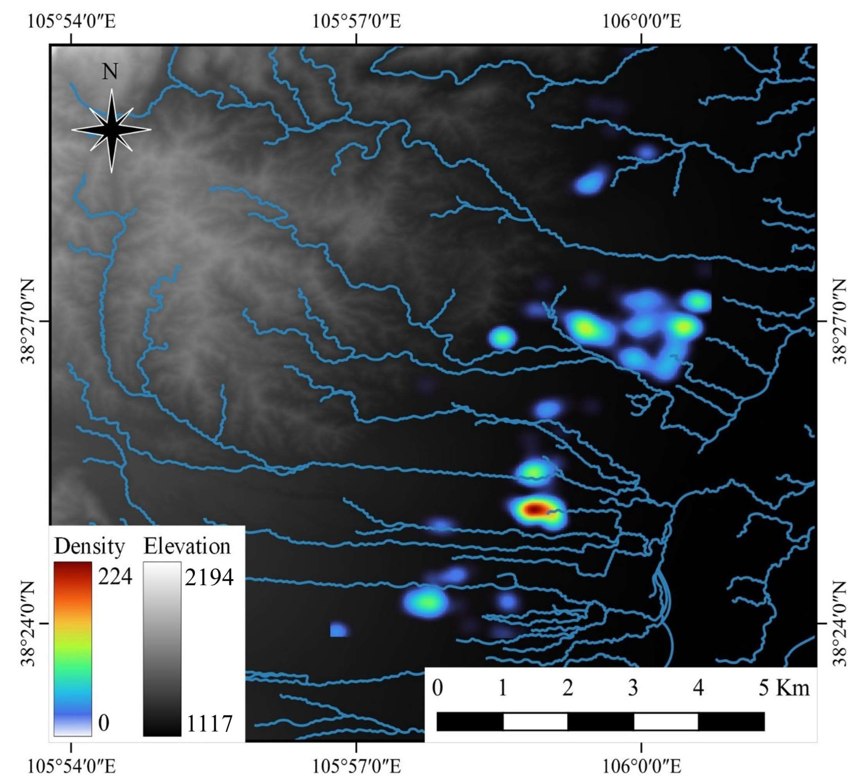
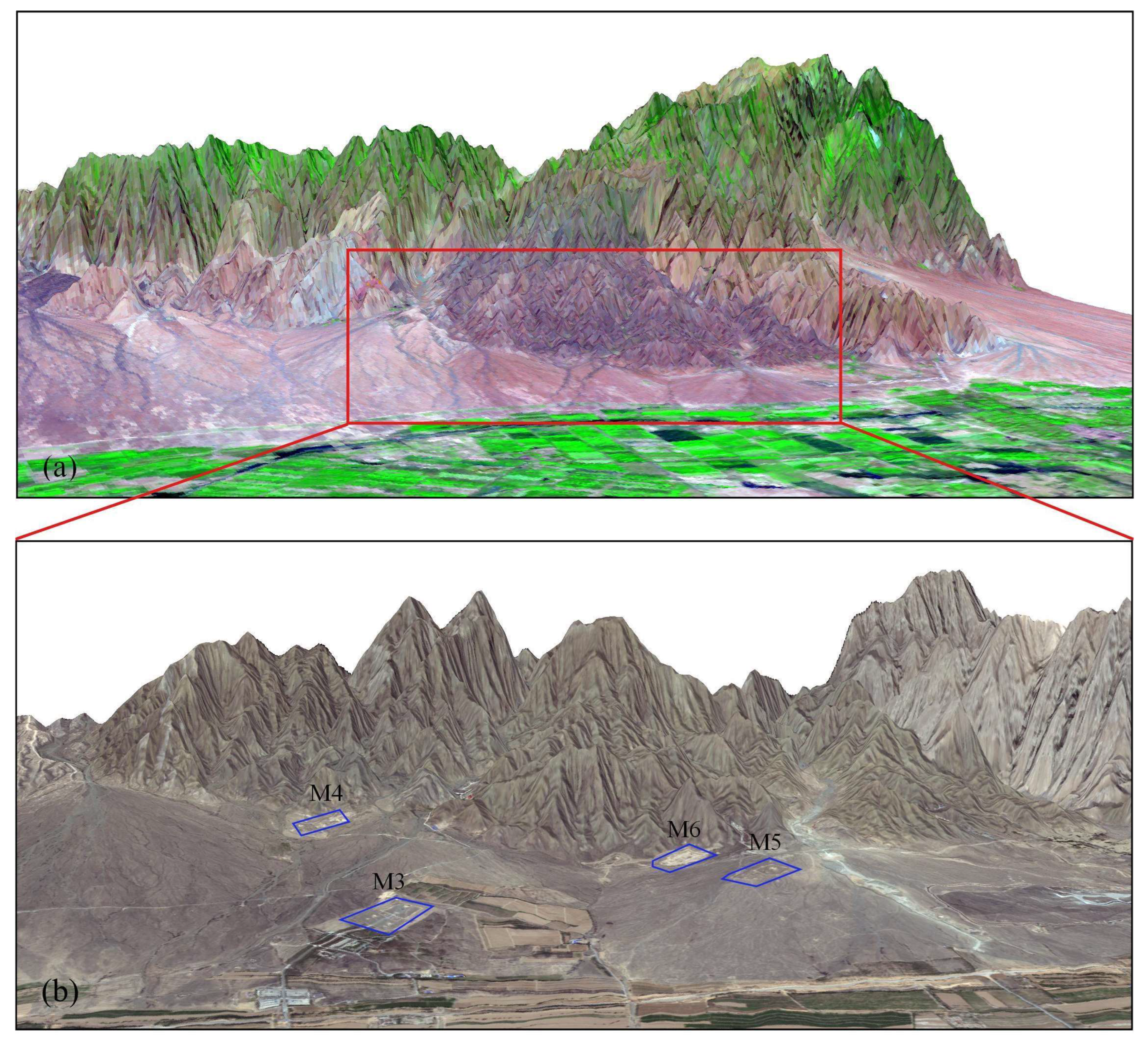
4.3. Subordinate Tombs in the XITs

In VHR optical satellite images of the XITs, the archaeological soil-marks of tomb mounds and sacred walls appear as approximately circular and linear geometric traces, respectively. Accordingly, the training dataset for XIT identification was created using two categories: “wall” for sacred walls and “mound” for tomb mounds (Figure 7).
The YOLOv5 model was trained for 300 epochs with a batch size of 8, achieving a stabilized accuracy of around 0.9 after approximately 200 epochs (Figure 8). Applying the trained model resulted in the identification of 135 mausoleum walls and 44 mausoleum mounds (Figure 9). False positives were observed, particularly related to modern constructions, such as modern tombs and oil storage tanks.
Since the XITs are located in the impact plain area with relatively low elevation, results within urban or mountainous environments were removed. Manual evaluation confirmed 113 correctly recognized walls and 31 correctly recognized mounds. The YOLOv5 model achieved a correct identification rate of 83.70% for walls and 70.45% for mounds. This suggests that features with square characteristics (walls) are more easily recognized than those with prototypical circular features (mounds). False positives, such as circular tanks or modern graves, were manually filtered based on contextual knowledge and cross-validation using GF-2 and GAMBIT imagery. This two-stage process (automated detection + expert verification) ensured high final precision while maintaining automation efficiency.

4.4. Top View and Geometric Characteristics of the Imperial Mausoleum

The XITs comprise a vast and complex burial landscape. The imperial mausoleums share a similar basic north–south oriented plan, as exemplified by Mausoleum M1 (Figure 10). The mausoleum complex includes ground buildings and an underground palace, although only the ground structures are visible from satellite imagery. Various funerary and ritual buildings are associated with the imperial mausoleum, such as the Tomb Mound, Sacred Wall, Hall of Offerings, Corner Platform, Magpie Platform, Sacred Way, Inner Enclosure, Outer Enclosure, Gate Tower, Corner Watchtower, Inscription Pavilion, Fish-back Ridge, and Stone Statues. Significant damage from historical events, such as the destruction by Khan’s cavalry, and ongoing anthropogenic activities and weathering have severely impacted the preservation of the XITs, with many original features having disappeared or been buried by sediment. Figure 10b depicts a typical model of a XIT mausoleum. This study focused on the most representative features, the tomb mounds and sacred walls, despite their deteriorated state. The construction technology of the tomb mounds reflects an innovative application of Tangut geomantic knowledge in designing burial landscapes in piedmont alluvial regions. VHR optical satellite remote sensing offers a unique perspective for archaeological prospecting of these features, allowing their traces to be observed from above, even when they are not easily visible on the ground.

4.5. Landscape Planning and Geomantic Considerations of the Imperial Mausoleum

Following the automated identification, manual interpretation was performed using high-resolution Google Earth imagery, resulting in a total of 248 identified mausoleums, including 9 imperial mausoleums and 239 subordinate tombs. Geospatial analysis based on the SRTM DEM revealed that the tombs are primarily distributed within an elevation range of 1140 to 1200 m, forming a roughly normal distribution. The terrain is predominantly gentle, with slopes concentrated between 0° and 4°, which is ideal for construction and ritual activities. Hydrological simulation using the Flow Accumulation and Flow Direction tools in ArcGIS demonstrated that most tomb sites avoid surface runoff channels, indicating a strategic selection process to minimize long-term erosion risks from rainfall (Figure 11).
Beyond physical geography, the spatial organization of the Xixia Imperial Tombs reflects deliberate geomantic planning that aligns with traditional Chinese and Tangut cosmological principles. The entire necropolis is situated on the eastern edge of a vast alluvial fan at the southeastern foothills of the Helan Mountains. The imperial tombs are aligned from north to south, facing southeast toward the Yinchuan Plain and the Yellow River. This spatial configuration embodies core feng shui principles—“mountain at the back, water at the front”—which symbolize imperial permanence and the flow of auspicious energy (qi). The Helan Mountains serve as both a physical and symbolic backdrop, while the southeast-facing orientation conforms to traditional beliefs about cosmic harmony.
The elevation and slope patterns further reinforce this geomantic logic. Imperial mausoleums tend to occupy the more elevated and central terrain, while subordinate tombs are arranged around them in flanking or crescent-shaped formations. Kernel density analysis revealed clustering patterns that were neither random nor dispersed, but rather radiated around the core imperial tombs, suggesting a spatial hierarchy that mirrors social and political order. This layout also reflects ritual and symbolic considerations, including the protection and accompaniment of emperors in the afterlife.
However, modern human activities have increasingly disrupted this well-preserved sacred landscape. Encroachment from contemporary construction—such as buildings between M5 and M6—and the expansion of farmland around sites like M3 have significantly reduced protective buffer zones (Figure 12). These changes pose serious threats to the visibility and integrity of the tombs, making it even more urgent to understand and preserve the spatial logic embedded in the original planning.
Taken together, the XITs represent not only individual tombs but a carefully constructed royal necropolis that integrates geomorphological suitability, hydrological security, and geomantic symbolism. The spatial logic and cosmological principles embedded in the tomb layout suggest that the Xixia Dynasty adopted a sophisticated macro-scale planning strategy, reflecting both inherited Chinese imperial traditions and their own cultural identity.

4.6. Proposed Location of the Lost Ninth Imperial Mausoleum

The Xixia Dynasty existed from 1038 A.D. until its conquest by the Mongols in 1227 A.D.. Founded by the Tangut ethnic group, much about their history remains unknown. Among the excavated imperial mausoleums, only M7, attributed to Emperor Renzong (Li Renxiao, 1139–1193 A.D.), has been adequately researched, revealing a pavilion-tower construction style fusing traditional mausoleum and temple architecture with Buddhist characteristics. Historical records provide titles for the emperors’ mausoleums but lack specific location descriptions. The destruction by the Mongolian army and subsequent illegal excavations have eliminated inscription information, making the identification of each imperial mausoleum’s owner a persistent unsolved mystery in Chinese historiography and archaeology.
Based on our analysis, particularly of VHR GAMBIT spy satellite images from 1964, we contend that the shape and architectural specifications of the M9 mausoleum identified by the cultural department in the late 1970s differ significantly from the other eight imperial tombs and likely do not belong to a Xixia Emperor. Our comparative analysis of VHR satellite images (Figure 6b) and the 1964 GAMBIT image revealed a suspected tomb north of M5 and M6 with a similar construction pattern (Figure 13). We propose that this suspected location represents the true ninth imperial tomb. This suspected tomb was likely not identified in the late 1970s investigation due to damage caused by the construction of military bases in the late 1960s. In addition, it should be acknowledged frankly and openly that the current research team does not include a professional archaeologist. To address this limitation, consultations with archaeological experts have been initiated to evaluate the remote-sensing-based hypothesis concerning the true location of the ninth imperial mausoleum (M9). This hypothesis, while supported by satellite imagery analysis and geomorphological patterns, remains preliminary in nature. It is intended as a contribution to ongoing scholarly discussions rather than a definitive conclusion. Future interdisciplinary collaboration, including field investigations and peer review by archaeological specialists, will be essential to validate or refine this interpretation.

5. Conclusions

This study successfully investigated the history, structure, and distribution of the XITs through the analysis of multi-source, multi-temporal remote sensing imagery. The HALF was introduced and applied to analyze the supporting environment of the XITs. DL, specifically YOLOv5, was employed for the automated identification of XITs in GE images. Subsequent manual interpretation of GAMBIT and GF-2 imagery provided accurate distribution data for the tombs. Furthermore, the structure of the imperial mausoleums was mapped and interpreted, and a key finding involved the investigation into the true location of the ninth imperial mausoleum. For well-preserved tombs, the deep learning method demonstrated high accuracy in automatic identification and extraction. However, in areas with complex backgrounds, the presence of objects with similar circular textures to tomb mounds resulted in some false positives. To enhance accuracy, the DL results were further refined through investigation using GAMBIT and GF-2 images. This integrated approach yielded the final distribution of 9 imperial tombs and 239 accompanying tombs. While M9 serves as a compelling case study, future research will expand systematically to cover the full set of imperial and subordinate tombs. A more comprehensive spatial–statistical analysis of site distribution, orientation, and spatial hierarchy will be conducted. Topographic analysis indicated that the XITs were strategically located in open and flat regions, facilitating material and manpower transportation during construction and subsequent worship activities. Hydrological analysis revealed that the tomb sites were chosen to avoid surface runoff, contributing to their prolonged preservation despite nearly eight centuries of neglect since the fall of the Xixia Dynasty. The Tangut civilization, a resilient ethnic minority in northwestern China, displayed remarkable adaptability and cultural diversity. The design of the XITs was influenced by the imperial mausoleum architecture of the Northern Song Dynasty, integrating Northern Song ritual systems and cultural achievements with unique Tangut traditions, including mountain worship, necromancy beliefs, and aesthetic preferences. This fusion highlights the inclusive character of Tangut civilization. The XITs, particularly the well-preserved imperial mausoleums like M1–M6, stand as a significant testament to the once-flourishing Tangut civilization, with their architectural structures clearly visible in remote sensing images. The subordinate tombs, as simplified imitations composed of outer sacred walls and tomb mounds, reflect a fixed set of rules and forms for tomb construction within the Xixia Dynasty. This underscores the unique culture and social structure of the Xixia civilization. This research demonstrates the powerful synergy of multi-source remote sensing data and deep learning for archaeological investigation and contributes valuable new insights into the XITs and the Tangut civilization.
Looking ahead, this study lays a foundation for several promising research directions. First, we plan to conduct multi-temporal change detection by leveraging satellite image time series (e.g., Landsat and Sentinel-2) and historical imagery (such as GAMBIT and CORONA) to monitor degradation, anthropogenic disturbances, and environmental changes around the Xixia Imperial Tombs (XITs). This will help quantify heritage risk levels and inform adaptive conservation strategies. Second, to enhance spatial understanding of tomb morphology, we aim to integrate 3D reconstruction techniques using stereo satellite imagery and UAV-derived structure-from-motion (SfM) models. These 3D models can reveal micro-topographic variations, erosion patterns, and structural deformations that are not easily captured in 2D imagery, contributing to virtual documentation and immersive visualization of the tomb sites. Third, the current deep learning pipeline requires extensive manual annotation, which can be time-consuming and subjective. To address this limitation, we propose developing semi-supervised or weakly supervised learning frameworks that can leverage limited labeled data alongside abundant unlabeled imagery to train detection models. This approach could significantly improve scalability for broader archaeological applications. Lastly, we recognize the importance of interdisciplinary collaboration. Future studies will involve archaeologists, historians, and cultural heritage managers to validate our remote sensing interpretations and refine hypotheses, especially concerning the newly identified M9 site. Ground-truthing, excavation data integration, and archaeological peer review will be essential steps toward confirming site attributions and contextualizing findings within the broader historical narrative of the Tangut civilization. Together, these future efforts aim to establish a comprehensive, data-driven, and archaeologically informed monitoring system that supports the long-term preservation and study of the XITs and other vulnerable heritage landscapes in northwest China.

Author Contributions

Conceptualization, W.J. and J.Y.; methodology, W.J.; software, Y.H.; validation, W.J., L.L. (Li Li) and Y.H.; formal analysis, J.Y.; investigation, J.Y. and L.L. (Lei Luo); resources, L.L. (Li Li); data curation, J.Y.; writing—original draft preparation, Y.H.; writing—review and editing, W.J. and L.L. (Lei Luo); visualization, Y.H. and L.L. (Li Li); supervision, L.L. (Li Li); project administration, L.L. (Lei Luo); funding acquisition, L.L. (Lei Luo). All authors have read and agreed to the published version of the manuscript.

Funding

This research was funded by the Construction of the China–Central Asia Human and Environment “Belt and Road” Joint Laboratory and Joint Research on Ancient Human Culture and Environment in the Sulh River Basin (Grant No. 2022YFE0203800, November 2022 to October 2025).

Data Availability Statement

The original contributions presented in this study are included in the article. Further inquiries can be directed to the corresponding author.

Acknowledgments

The authors thank four anonymous reviewers for their helpful comments, which improved this manuscript. Many thanks are due to the China Centre for Resource Satellite Data and Applications for providing the GF-1 VHR remote sensing data that were used in this study.

Conflicts of Interest

Author Wei Ji was employed by the company Zhongwang (Nanjing) Information Technology Co., Ltd. The remaining authors declare that the research was conducted in the absence of any commercial or financial relationships that could be construed as a potential conflict of interest.

References

  1. McGrath, M.C. Frustrated Empires: The Song-Tangut Xia War of 1038–1044. In Battlefronts Real and Imagined: War, Border, and Identity in the Chinese Middle Period; Wyatt, D.J., Ed.; Palgrave Macmillan US: New York, NY, USA, 2008; pp. 151–190. [Google Scholar]
  2. Takayasu, S. Defense Challenges for the Capital of the Xi Xia (Tangut) Kingdom: Evidence from Research on Khara-Khoto Documents from around 1210. Cent. Asiat. J. 2014, 57, 201–208. [Google Scholar]
  3. Jisheng, X. The Murals of Mogao Cave 465: New Evidence for 12th Century Tangut Xia Patronage. Orientations 2004, 35, 38–45. [Google Scholar]
  4. Solonin, K.J. Buddhist Connections between the Liao and Xixia: Preliminary Considerations. J. Song-Yuan Stud. 2013, 43, 171–219. [Google Scholar] [CrossRef]
  5. Wyatt, D.J. (Ed.) Battlefronts Real and Imagined; Palgrave Macmillan US: New York, NY, USA, 2008. [Google Scholar]
  6. Jing, X. A Study of The Costume Culture of The Xixia’s Donors at Dunhuang Grottoes. Dunhuang Res. 2007, 24–31. [Google Scholar]
  7. Beckwith, C.I. Empires of the Silk Road: A History of Central Eurasia from the Bronze Age to the Present; Princeton University Press: Princeton, NJ, USA, 2009. [Google Scholar]
  8. Di Cosmo, N.; Wyatt, D.J. (Eds.) Political Frontiers, Ethnic Boundaries and Human Geographies in Chinese History; Routledge: Oxfordshire, UK, 2005. [Google Scholar]
  9. Kepping, K.B.; van Driem, G. The Name of the Tangut Empire. T’oung Pao 1994, 80, 357–376. [Google Scholar] [CrossRef]
  10. Steinhardt, N.S. The Tangut Royal Tombs near Yinchuan. Muqarnas 1993, 10, 369–381. [Google Scholar] [CrossRef]
  11. Dunnell, R.W. Who Are the Tanguts? Remarks on Tangut Ethnogenesis and the Ethnonym Tangut. J. Asian Hist. 1984, 18, 78–89. [Google Scholar]
  12. Renyong, L.U. Xixia’s boundaries and borders. J. Ningxia Univ. 2003, 38–41. [Google Scholar]
  13. Rui, Y. A Review of the Geography of Xixia. Ningxia Soc. Sci. 2004, 87–91. [Google Scholar]
  14. Yao, L.U. Boundary Changes of the Song, Liao, Xia and Jin Regimes in the Ordos Plateau Region. Master’s Thesis, Shaanxi Normal University, Shaanxi, China, 2015. [Google Scholar]
  15. Grousset, P.R. The Empire of the Steppes: A History of Central Asia; Rutgers University Press: New Brunswick, NJ, USA, 1970. [Google Scholar]
  16. Liu, Q. Archaeological Discovery and Research of Imperial Mausoleums. In A History of Un-fractured Chinese Civilization in Archaeological Interpretation; Springer Nature: Singapore, 2022; pp. 273–457. [Google Scholar]
  17. Pankenier, D.W. Astronomy and City Planning in China. In Handbook of Archaeoastronomy and Ethnoastronomy; Ruggles, C.L.N., Ed.; Springer: New York, NY, USA, 2015; pp. 2085–2093. [Google Scholar]
  18. Luo, L.; Wang, X.; Guo, H. Contribution of UNESCO Designated Sites to the Achievement of Sustainable Development Goals. Innovation 2022, 3, 100227. [Google Scholar] [CrossRef]
  19. Madeddu, M.; Zhang, X. Harmonious Spaces: The Influence of Feng Shui on Urban Form and Design. J. Urban Des. 2017, 22, 709–725. [Google Scholar] [CrossRef]
  20. Cui, J.; Liu, Y.; Sun, J.; Hu, D.; He, H. Study on Feng Shui (Geomantic) Suitability Evaluation of Mausoleums in Nanjing City Based on GIS. ISPRS Int. J. Geo Inf. 2021, 10, 752. [Google Scholar] [CrossRef]
  21. Madeddu, M.; Zhang, X. Feng Shui and the Meaning of Space. In Feng Shui and the City: The Private and Public Spaces of Chinese Geomancy; Madeddu, M., Zhang, X., Eds.; Springer: Singapore, 2021; pp. 1–33. [Google Scholar]
  22. Baratta, N.C.; Magli, G. The Role of Astronomy and Feng Shui in the Planning of Ming Beijing. Nexus Netw. J. 2021, 23, 767–787. [Google Scholar] [CrossRef]
  23. Stratoulias, D.; Grekousis, G. Information Extraction and Population Estimates of Settlements from Historic Corona Satellite Imagery in the 1960s. Sensors 2021, 21, 2423. [Google Scholar] [CrossRef]
  24. Shahbandeh, M.; Kaim, D.; Kozak, J. Using CORONA Imagery to Study Land Use and Land Cover Change-a Review of Applications. Remote Sens 2023, 15, 2793. [Google Scholar] [CrossRef]
  25. Ricci, A.; Jalilov, B.; Fiori, S.; Erkul, E.; Kneisel, J.; Fischer, S.; Raese, H.; Rabbel, W. Kurgan Phenomenon in the Southern Caucasus: Results of an Interdisciplinary Multi-Method Remote Sens. Survey along the Kurekçay Valley (Goranboy Province, Western Azerbaijan). Archaeol. Prospect. 2025, 32, 159–177. [Google Scholar] [CrossRef]
  26. Lim, J.; Matás, G. Dunes, Death, and Datasets: Modelling Funerary Monument Construction in Remote Arid Landscapes Using Spaceborne Stereo Imagery. J. Archaeol. Sci. 2023, 156, 105815. [Google Scholar] [CrossRef]
  27. Luo, L.; Wang, X.; Liu, J.; Zheng, W.; Zhen, J.; Zhu, L.; Liu, C.; Wan, H. Low-Cost Archaeological Investigation and Rapid Mapping of Ancient Stone Tidal Weirs in the Penghu Archipelago Using Google Earth. Sustainability 2019, 11, 4536. [Google Scholar] [CrossRef]
  28. Luo, L.; Wang, X.; Guo, H.; Lasaponara, R.; Zong, X.; Masini, N.; Wang, G.; Shi, P.; Khatteli, H.; Chen, F.; et al. Airborne and spaceborne remote sensing for archaeological and cultural heritage applications: A review of the century (1907–2017). Remote Sens. Environ. 2019, 232, 111280. [Google Scholar] [CrossRef]
  29. Yang, H.; Wang, S.; Wang, S.; Zhao, P.; Ai, M.; Hu, Q. Moated Site Object Detection Using Time Series Satellite Imagery and an Improved Deep Learning Model in Northeast Thailand. J. Archaeol. Sci. 2024, 171, 106070. [Google Scholar] [CrossRef]
  30. Valente, R.; Maset, E.; Iamoni, M. Three Years of Google Earth Engine-Based Archaeological Surveys in Iraqi Kurdistan: Results from the Ground. Remote Sens. 2024, 16, 4229. [Google Scholar] [CrossRef]
  31. Valente, R.; Maset, E.; Iamoni, M. Archaeological Site Identification from Open Access Multispectral Imagery: Cloud Computing Applications in Northern Kurdistan (Iraq). Archaeol. Prospect. 2022, 29, 579–595. [Google Scholar] [CrossRef]
  32. Bulawka, N.; Orengo, H. Application of Multi-Temporal and Multisource Satellite Imagery in the Study of Irrigated Landscapes in Arid Climates. Remote Sens. 2024, 16, 1997. [Google Scholar] [CrossRef]
  33. Elfadaly, A.; Shams, A.; Elbehery, W.; Elftatry, M.; Wafa, O.; Hiekl, A.; Wilson, P.; Silverstein, J.; Abouarab, M. Revealing the Paleolandscape Features around the Archaeological Sites in the Northern Nile Delta of Egypt Using Radar Satellite Imagery and GEE Platform. Archaeol. Prospect. 2022, 29, 369–384. [Google Scholar] [CrossRef]
  34. Elfadaly, A.; Abate, N.; Masini, N.; Lasaponara, R. SAR Sentinel 1 Imaging and Detection of Palaeo-Landscape Features in the Mediterranean Area. Remote Sens. 2020, 12, 2611. [Google Scholar] [CrossRef]
  35. Tapete, D.; Cigna, F.; Donoghue, D. ‘Looting marks’ in space-borne SAR imagery: Measuring rates of archaeological looting in Apamea (Syria) with TerraSAR-X Staring Spotlight. Remote Sens. Environ. 2016, 178, 42–58. [Google Scholar] [CrossRef]
  36. Comer, D.; Comer, J.; Dumitru, I.; Ayres, W.; Levin, M.; Seikel, K.; White, D.; Harrower, M. Airborne LiDAR Reveals a Vast Archaeological Landscape at the Nan Madol World Heritage Site. Remote Sens. 2019, 11, 2152. [Google Scholar] [CrossRef]
  37. Küçükdemirci, M.; Landeschi, G.; Ohlsson, M.; Dell’Unto, N. Investigating Ancient Agricultural Field Systems in Sweden from Airborne LIDAR Data by Using Convolutional Neural Network. Archaeol. Prospect. 2023, 30, 209–219. [Google Scholar] [CrossRef]
  38. Luo, L.; Zong, X.; Shao, J.; Wang, X.; Guo, H. LiDARchaeology: A Revolutionary Approach to Archaeol Prospect in Forested Areas. Innov. Geosci. 2023, 1, 100017. [Google Scholar] [CrossRef]
  39. Canuto, M.; Estrada-Belli, F.; Garrison, T.; Houston, S.; Acuna, M.; Kovac, M.; Marken, D.; Nondédéo, P.; Auld-Thomas, L.; Castanet, C.; et al. Ancient lowland Maya complexity as revealed by airborne laser scanning of northern Guatemala. Science 2018, 361, eaau0137. [Google Scholar] [CrossRef]
  40. Bachagha, N.; Wang, X.; Luo, L.; Li, L.; Khatteli, H.; Lasaponara, R. Remote Sensing and GIS Techniques for Reconstructing the Military Fort System on the Roman Boundary (Tunisian Section) and Identifying Archaeological Sites. Remote Sens. Environ. 2020, 236, 111418. [Google Scholar] [CrossRef]
  41. Yang, S.; Luo, L.; Li, Q.; Chen, Y.; Wu, L.; Wang, X. Auto-Identification of Linear Archaeological Traces of the Great Wall in Northwest China Using Improved DeepLabv3+from Very High-Resolution Aerial Imagery. Int. J. Appl. Earth Obs. 2022, 113, 102995. [Google Scholar] [CrossRef]
  42. El-Behaedi, R. Detection and 3D Modeling of Potential Buried Archaeological Structures Using WorldView-3 Satellite Imagery. Remote Sens. 2022, 14, 92. [Google Scholar] [CrossRef]
  43. Luo, L.; Liu, J.; Cigna, F.; Evans, D.; Hernandez, M.; Tapete, D.; Shadie, P.; Agapiou, A.; Elfadaly, A.; Chen, M.; et al. Space technology: A powerful tool for safeguarding world heritage. Innovation 2023, 4, 100420. [Google Scholar] [CrossRef] [PubMed]
  44. Luo, L.; Wang, X.; Guo, H. Remote Sensing Archaeology: The next Century. Innovation 2022, 3, 100335. [Google Scholar] [CrossRef]
  45. Lasaponara, R.; Leucci, G.; Masini, N.; Persico, R.; Scardozzi, G. Towards an Operative Use of Remote Sensing for Exploring the Past Using Satellite Data: The Case Study of Hierapolis (Turkey). Remote Sens. Environ. 2016, 174, 148–164. [Google Scholar] [CrossRef]
  46. Luo, L.; Wang, X.; Liu, J.; Guo, H.; Zong, X.; Ji, W.; Cao, H. VHR GeoEye-1 imagery reveals an ancient water landscape at the Longcheng site, northern Chaohu Lake Basin (China). Int. J. Digit. Earth 2017, 10, 139–154. [Google Scholar] [CrossRef]
  47. Casana, J. Global-Scale Archaeological Prospection Using CORONA Satellite Imagery: Automated, Crowd-Sourced, and Expert-Led Approaches. J. Field Archaeol. 2020, 45, S89–S100. [Google Scholar] [CrossRef]
  48. Ur, J.A. CORONA Satellite Imagery and Ancient Near Eastern Landscapes. In Mapping Archaeological Landscapes from Space; Comer, D.C., Harrower, M.J., Eds.; Springer: New York, NY, 2013; pp. 21–31. [Google Scholar]
  49. Rizayeva, A.; Nita, M.D.; Radeloff, V.C. Large-Area, 1964 Land Cover Classifications of Corona Spy Satellite Imagery for the Caucasus Mountains. Remote Sens. Environ. 2023, 284, 113343. [Google Scholar] [CrossRef]
  50. Watanabe, N.; Nakamura, S.; Liu, B.; Wang, N. Utilization of Structure from Motion for Processing CORONA Satellite Images: Application to Mapping and Interpretation of Archaeological Features in Liangzhu Culture, China. Archaeol. Res. Asia 2017, 11, 38–50. [Google Scholar] [CrossRef]
  51. Lasaponara, R.; Yang, R.; Chen, F.; Li, X.; Masini, N. Corona Satellite Pictures for Archaeological Studies: A Review and Application to the Lost Forbidden City of the Han–Wei Dynasties. Surv. Geophys. 2018, 39, 1303–1322. [Google Scholar] [CrossRef]
  52. Li, C.; Hong, D.; Zhang, B.; Liao, T.; Yokoya, N.; Ghamisi, P.; Chen, M.; Wang, L.; Benediktsson, J.A.; Chanussot, J. Interpretable Foundation Models as Decryptors Peering into the Earth System. Innovation 2024, 5, 2100682. [Google Scholar] [CrossRef] [PubMed]
  53. Xu, Y.; Liu, X.; Cao, X.; Huang, C.; Liu, E.; Qian, S.; Liu, X.; Wu, Y.; Dong, F.; Qiu, C.-W.; et al. Artificial Intelligence: A Powerful Paradigm for Scientific Research. Innovation 2021, 2, 100179. [Google Scholar] [CrossRef] [PubMed]
  54. Song, D.; Yang, W.; Zhao, P. Photogrammetry and Remote Sensing Project in Survey of the Emperor Qin Shi Huang’s Mausoleum. In Close-Range Photogrammetry Meets Machine Vision; SPIE: Bellingham, WA, USA, 1990; Volume 1395, pp. 651–660. [Google Scholar]
  55. Tan, K.; Wan, Y.; Zhou, X.; Song, D.; Duan, Q. The application of remote sensing technology in the archaeological study of the Mausoleum of Emperor Qinshihuang. Int. J. Remote Sens. 2006, 16, 3347–3363. [Google Scholar] [CrossRef]
  56. Shanti, P.; Kumar, A.; Ravindranath, S.; Raj, U. Applications of Satellite Remote Sensing for Research and Heritage Management in Indian Prehistory. J. Archaeol. Sci. 2010, 37, 2316–2331. [Google Scholar] [CrossRef]
  57. Parcak, S.; Gathings, D.; Childs, C.; Mumford, G.; Cline, E. Satellite evidence of archaeological site looting in Egypt: 2002–2013. Antiquity 2016, 90, 188–205. [Google Scholar] [CrossRef]
  58. Magli, G. Astronomy and Feng Shui in the projects of the Tang, Ming and Qing royal mausoleums: A satellite imagery approach. Archaeol. Res. Asia 2019, 17, 98–108. [Google Scholar] [CrossRef]
  59. Magli, G. The Sacred Landscape of the “Pyramids” of the Han Emperors: A Cognitive Approach to Sustainability. Sustainability 2019, 11, 789. [Google Scholar] [CrossRef]
  60. Magli, G. Royal Mausoleums of the Western Han and of the Song Chinese Dynasties: A Satellite Imagery Analysis. Archaeol. Res. Asia 2018, 15, 45–54. [Google Scholar] [CrossRef]
  61. Wulf Diether Graf Zu Castell. Chinaflug; Herbig: München, Germany, 1999; pp. 154–196. [Google Scholar]
  62. Ducart, D.F.; Silva, A.M.; Toledo, C.L.B.; Assis, L.M.d. Mapping iron oxides with Landsat-8/OLI and EO-1/Hyperion imagery from the Serra Norte iron deposits in the Carajás Mineral Province, Brazil. Brazilian J. Geol. 2016, 46, 331–349. [Google Scholar] [CrossRef]
  63. D’Arcy, M.; Mason, P.J.; Roda-Boluda, D.C. Alluvial fan surface ages recorded by Landsat-8 imagery in Owens Valley, California. Remote Sens. Environ. 2018, 216, 401–414. [Google Scholar] [CrossRef]
  64. Jocher, G. Ultralytics/Yolov5. 2022. Available online: https://github.com/ultralytics/yolov5 (accessed on 24 November 2021).
Figure 1. (a) Low-altitude drone-based photograph of the No. 1 and No. 2 Mausoleums of the XITs. (bd) Photos of the unearthed Tangut cultural relics in areas around the XITs, which can be downloaded from the website of the XITs Museum (https://xixia.nxu.edu.cn/jdly/ww.htm (accessed on 12 June 2025)).
Remotesensing 17 02395 g001
Figure 2. General locations of the Ningxia Hui Autonomous Region (a) in China and the topography (b) of the area enclosed by the black box in (a) and the QuickBird true-color composite imagery of the archaeological area of the XITs (c) in the covering area enclosed by red boxes in (b).
Remotesensing 17 02395 g002
Figure 3. The workflow of identification of XITs using YOLOv5.
Remotesensing 17 02395 g003
Figure 4. Modern buildings and ancient sites. (a) Taomengou mining area, (b) Helan Mountain airport, (c) the Muslim cemetery area, (d) XITs, and (e) ancient river channels.
Remotesensing 17 02395 g004
Figure 5. Sub-band and color synthesis image of the Helan Mountain Alluvial Fan Index (HALF). In the HALF color composite, color gradients correspond to environmental parameters. Yellow represents high vegetation (RVI) and low clay content (CI), indicative of human-disturbed areas, such as tourist zones. Blue tones indicate low vegetation and high clay, typical of modern constructions or compacted burial areas. Green tones suggest natural alluvial fan surfaces with moderate indices. These interpretations provide archaeological insight into both anthropogenic impact and preservation states.
Remotesensing 17 02395 g005
Figure 6. The GE VHR imagery (© 2021 Maxar Technologies, acquired on 5 April 2005) of the archaeological area of the XITs (a). The nine imperial mausoleums are marked “M1” through “M9” from south to north, as shown in blue on the map. The recent GE VHR images of (b,c,e) (© 2021 Maxar Technologies, acquired on 10 February 2020) and of (d) (© 2021 Maxar Technologies, acquired on 25 March 2020) in covering areas enclosed by red boxes in (a).
Remotesensing 17 02395 g006
Figure 7. Schematic diagram of the sample labeling. The blue box labeled “wall” indicates the sacred walls of the mausoleum, and the green box labeled “mound” indicates the tomb mounds of the mausoleum.
Remotesensing 17 02395 g007
Figure 8. Precision curve with epoch of the YOLOv5 model during training.
Remotesensing 17 02395 g008
Figure 9. The identification results of XITs. The green boxes contain the main bodies of XITs, and the blue boxes are the extent of the mausoleum, including the enclosure.
Remotesensing 17 02395 g009
Figure 10. The top-view imagery (a) and layout (b) of the M1.
Remotesensing 17 02395 g010
Figure 11. Results of hydrological analysis and density analysis of the XITs in the study area. The density of tombs increases from blue to red, the elevation increases from black to white, and the blue line shows the surface runoff simulated by the hydrological analysis.
Remotesensing 17 02395 g011
Figure 12. 3D view of the XITs based on the DEM and satellite imagery. Landsat-8 images are used in (a), and GF-2 images are used in (b). The blue boxes in (b) indicate the boundaries of M3, M4, M5, and M6.
Remotesensing 17 02395 g012
Figure 13. GAMBIT spy satellite image (top) and GE image (bottom) showing the suspected location of the true ninth imperial mausoleum (M9), which presents a high potential for archaeological confirmation pending future field investigations.
Remotesensing 17 02395 g013
Table 1. Characteristics of GF-2 PMS data.
Imaging SensorsSpectral Wavelength/nmSpatial Resolution/m
GF-2 PMSPAN450–9000.8
MSB1-Blue: 450–5203.2
B2-Green: 520–590
B3-Red: 630–690
B4-NIR: 770–890
Table 2. LS-8 OLI band-ratio combinations used to characterize the feature.
NameBand-Ratio CombinationsReferences
LS-5 TMLS-8 OLI
RVI3/24/3[62]
AFI5/16/2[63]
CI(5/7)/(4/3)(6/7)/(5/4)[62]
Disclaimer/Publisher’s Note: The statements, opinions and data contained in all publications are solely those of the individual author(s) and contributor(s) and not of MDPI and/or the editor(s). MDPI and/or the editor(s) disclaim responsibility for any injury to people or property resulting from any ideas, methods, instructions or products referred to in the content.

