Article

Predictive Assessment of Forest Fire Risk in the Hindu Kush Himalaya (HKH) Region Using HIWAT Data Integration

1
Institute for Life Sciences and the Environment (ILSE), University of Southern Queensland, Toowoomba, QLD 4350, Australia
2
Northwest Institute of Eco-Environment and Resources, Chinese Academy of Sciences, Lanzhou 730000, China
3
School of Health, Medical and Applied Sciences, Central Queensland University, Rockhampton, QLD 4701, Australia
4
International Centre for Integrated Mountain Development (ICIMOD), Kathmandu 44600, Nepal
5
School of Surveying and Built Environment, University of Southern Queensland, Toowoomba, QLD 4350, Australia
6
Institute of Environmental Science and Meteorology, University of the Philippines Diliman, Quezon City 1101, Philippines
*
Author to whom correspondence should be addressed.
Remote Sens. 2025, 17(13), 2255; https://doi.org/10.3390/rs17132255
Submission received: 7 May 2025 / Revised: 26 June 2025 / Accepted: 27 June 2025 / Published: 30 June 2025
(This article belongs to the Section Environmental Remote Sensing)

Abstract

Forest fires in the Hindu Kush Himalaya (HKH) region are increasing in frequency and severity, driven by climate variability, prolonged dry periods, and human activity. Nepal, a critical part of the HKH, recorded over 22,700 forest fire events in the past decade, with fire incidence nearly doubling in 2023. Despite this growing threat, operational early warning systems remain limited. This study presents Nepal’s first high-resolution early fire risk outlook system, developed by adopting the Canadian Fire Weather Index (FWI) using meteorological forecasts from the High-Impact Weather Assessment Toolkit (HIWAT). The system generates daily and two-day forecasts using a fully automated Python-based workflow and publishes results as Web Map Services (WMS). Model validation against MODIS, VIIRS, and ground fire records for 2023 showed that over 80% of fires occurred in zones classified as Moderate to Very High risk. Spatiotemporal analysis confirmed fire seasonality, with peaks in mid-April and over 65% of fires occurring in forested areas. The system’s integration of satellite data and high-resolution forecasts improves the spatial and temporal accuracy of fire danger predictions. This research presents a novel, scalable, and operational framework tailored for data-scarce and topographically complex regions. Its transferability holds substantial potential for strengthening anticipatory fire management and climate adaptation strategies across the HKH and beyond.

Graphical Abstract

1. Introduction

Nature or human-induced forest fires pose a growing threat to ecosystems, biodiversity, climate stability, and human livelihoods worldwide, with their frequency, intensity, and unpredictability exacerbated by climate change [1,2,3,4]. Nowhere is this threat more acute than in the Hindu Kush Himalaya (HKH) region, often referred to as the “water tower of Asia”, which is one of the world’s most ecologically and socially sensitive mountain systems [5,6,7]. The HKH spans eight countries (Afghanistan, Bangladesh, Bhutan, China, India, Myanmar, Nepal, and Pakistan) and provides critical ecosystem services that directly sustain 240 million people and benefit an additional 1.65 billion downstream [8,9,10].
The region’s vulnerability to forest fires is intensifying due to rising temperatures, altered precipitation patterns, extended droughts, and increasing anthropogenic pressures, such as land-use change, infrastructure expansion, and forest encroachment [10,11,12]. The forest fires across the HKH region are also becoming more frequent, severe, and erratic, threatening carbon sinks, fragile mountain ecosystems, water regulation services, endangered species, and the safety and livelihoods of mountain communities [13,14].
Despite this growing risk, most HKH countries lack operational, region-specific fire danger forecasting systems capable of supporting early warning, mitigation planning, and rapid response. The absence of such tailored tools hinders disaster preparedness and undermines efforts to build climate resilience services across the region. For instance, Nepal, centrally located within the HKH, recorded over 375,000 hectares of forest burned over one and a half decades and reported more than 22,700 forest fire incidents in the past decade, with a dramatic spike in 2023 [15,16,17,18]. The development and implementation of localized fire danger systems could therefore be both instrumental and transformative for the region. With 43.38% forest cover [19] in Nepal, the Siwalik and Middle Mountain regions are particularly fire-prone due to the abundance of dry biomass, intense pre-monsoon drought, and frequent ignition sources [11,20]. This rising trend reflects broader patterns seen across the HKH and highlights the urgent need for accurate, high-resolution, and locally adjusted fire risk prediction systems.
Globally, Earth Observation (EO) and remote sensing (RS) tools, such as the Moderate Resolution Imaging Spectroradiometer (MODIS) and the Visible Infrared Imaging Radiometer Suite (VIIRS), have been widely used to monitor active fires, assess burned areas, and map fire-prone zones [21,22,23]. However, fire detection alone is insufficient for proactive management. Predictive capabilities that integrate meteorological forecasts and fuel dynamics are critical for anticipating fire danger and informing timely interventions. Fire Danger Rating Systems (FDRS), such as the Canadian Forest Fire Danger Rating System (CFFDRS), the U.S. National Fire Danger Rating System (NFDRS), and Australia’s McArthur Forest Fire Danger Index (FFDI), offer proven frameworks to assess fire risk by incorporating temperature, humidity, wind speed, precipitation, and fuel moisture content [24,25,26,27,28,29,30]. Among these, the Canadian Fire Weather Index (FWI) stands out for its simplicity, adaptability, and robust global application [31,32].
Despite the global relevance of early fire warning systems, the HKH region, particularly countries such as Nepal, India, Bhutan, Pakistan, Bangladesh, and Myanmar, remains significantly underrepresented in the development and application of such predictive systems. These countries lack high-resolution, real-time fire risk forecasting platforms that incorporate local weather variability, fuel conditions, and real-time fire observations. This results in a critical gap between scientific capabilities and operational needs [9,33].
To address this gap, this study introduces Nepal’s first operational early fire risk prediction system tailored for the HKH context. The system adapts the Canadian Fire Weather Index (FWI) using high-resolution meteorological forecasts from the High-Impact Weather Assessment Toolkit (HIWAT), a NASA and ICIMOD-supported platform that blends satellite data with numerical weather prediction models to monitor high-impact weather events in the region [33]. By integrating satellite-based fire data (MODIS, VIIRS) and ground-based forest fire records, the system offers significantly improved spatial and temporal accuracy in forecasting forest fire danger. The model is embedded in a web-based operational platform that automatically processes maps and disseminates fire risk predictions in near-real time. This platform is designed for decision-makers, disaster response agencies, and local communities, bridging the gap between science and action. This approach aligns with global best practices in disaster risk reduction and early warning systems, which emphasize the importance of localized, people-centered, and actionable information [34].
While the system is currently applied in Nepal, its design is inherently adaptable to other HKH countries facing similar ecological and climatic vulnerabilities. As highlighted in the Hindu Kush Himalaya Assessment and related studies on disaster resilience [7,9], such region-specific innovations are essential for building long-term climate resilience in one of the world’s most hazard-prone mountain regions [6]. This study thus demonstrates a feasible forest fire risk prediction system developed and operationalized for Nepal and scalable for the HKH region.

2. Materials and Methods
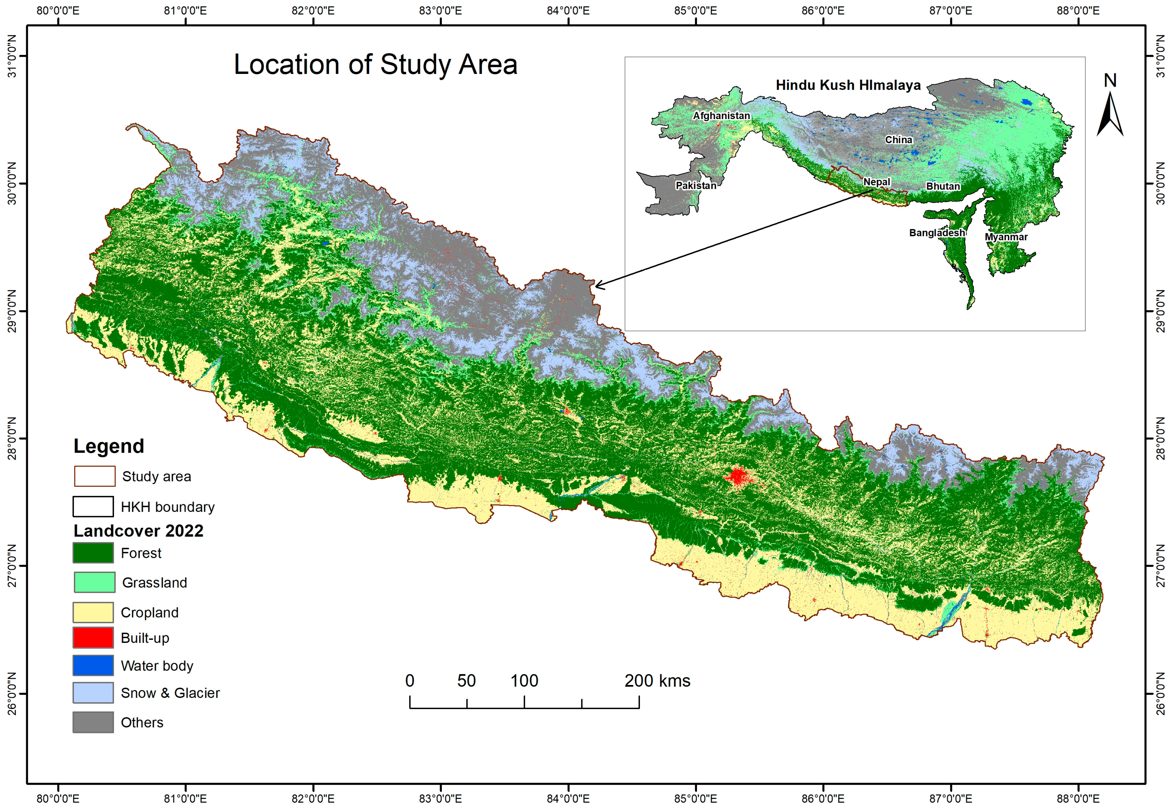
2.1. Study Area

Nepal (Figure 1), situated between 26°22′N to 30°27′N latitude and 80°40′E to 88°12′E longitude, with the neighboring countries China in the North, and India in the south, east, and west. Nepal exhibits diverse topography and ecological zones, with a dominant forest cover of around 43.38% [19].
To address the urgent need for region-specific forest fire forecasting in Nepal’s data-scarce and topographically complex environment, this study developed and operationalized a national early fire danger prediction system. The system integrates high-resolution meteorological forecasts, satellite-based fire observations, and the Canadian Fire Weather Index (FWI) to generate spatially explicit, near-real-time fire risk outlooks. Automated data processing and web-based dissemination enable proactive fire management at national and subnational levels.
The methodological framework guiding the system’s development is presented in Figure 2, illustrating the key steps from data acquisition and preprocessing to FWI computation, validation, and dissemination. The framework is designed for replicability and adaptability across similar mountainous regions.

2.2. Data Acquisition and Processing

This study integrated three primary data sources to support the development and validation of Nepal’s forest fire risk prediction system: high-resolution meteorological forecasts, satellite-based fire detection products, and field-based fire incident records.

2.2.1. High-Impact Weather Assessment Toolkit (HIWAT) Data

Meteorological input data were sourced from the High-Impact Weather Assessment Toolkit (HIWAT), a convection-allowing ensemble forecast system developed by NASA SERVIR to address high-impact weather in the Hindu Kush Himalaya (HKH) region [33,35]. HIWAT provides probabilistic 54-h forecasts at a spatial resolution of 4 km, enabling precise prediction of mesoscale phenomena such as convective thunderstorms, which are critical drivers of fire weather extremes [33].
The HIWAT system couples the Weather Research and Forecasting (WRF) model with Global Precipitation Measurement (GPM) satellite data, offering high-resolution, ensemble-based forecasts of key meteorological variables. These variables include air temperature (°C), relative humidity (%), wind speed (km/h), and 24-h accumulated precipitation (mm), recorded at 12:00 PM local time. These high-resolution forecasts provided the dynamic meteorological foundation for daily fire risk estimation.

2.2.2. MODIS & VIIRS Data

To monitor fire activity and assess burned area patterns, satellite-based datasets were acquired from the Moderate Resolution Imaging Spectroradiometer (MODIS) and the Visible Infrared Imaging Radiometer Suite (VIIRS)—two of the most widely used Earth Observation systems for global fire monitoring.
MODIS, onboard NASA’s Terra and Aqua satellites, offers high temporal resolution (up to four observations per day), 36 spectral bands, and moderate spatial resolutions (250 m, 500 m, and 1000 m). These capabilities make MODIS effective in detecting active fires and mapping burned areas [23,36].
VIIRS, operated by the Suomi NPP and NOAA-20 satellites, offers improved spatial resolution (375 m for active fires and 750 m for thermal bands) and enhanced nighttime fire detection due to its 22 spectral bands [37]. The VIIRS 375 m active fire product is particularly suited for detecting small, low intensity fires and complements MODIS fire data [38].
Daily active fire datasets from MODIS and VIIRS were accessed via NASA’s Fire Information for Resource Management System (FIRMS). These datasets use contextual algorithms to detect thermal anomalies in near real-time [39]. To enhance reliability, only pixels with ≥50% detection confidence were retained. All fire points were clipped to Nepal’s national boundary to isolate fire events within the country.
In addition to active fire detection, the MODIS Burned Area Product (MCD64A1, Collection 6) was used. This product provides monthly estimates of burned areas at a 500-m resolution, and the 2023 dataset was processed to identify fire-affected regions and estimate burned extents, supporting fire pattern validation [39].

2.2.3. Field Data

Field data were collected by staff from the Department of Forests and Soil Conservation (DoFSC) through a standardized Damage Assessment Form, which has been integrated into a centralized web-based reporting system. This tool enables DoFSC officials at the local level to systematically record key information following a forest fire incident, including the following:
  • Date and location of the incident;
  • Estimated area burned;
  • Type and extent of damage to forest resources and infrastructure;
  • Reported casualties or fatalities (if any).
Upon the occurrence of a forest fire, DoFSC staff from the respective district are responsible for conducting site assessments and submitting the completed forms, which are then stored in a central database.

2.3. Fire Weather Index Calculation

To operationalize fire risk prediction across Nepal, the Canadian Forest Fire Weather Index (FWI) System was adopted. The FWI System is a well-established framework used globally to estimate forest fire danger based on the combined effects of weather on fuel moisture and fire behavior [27,40,41].
The FWI System computes six key indices as follows:
  • Fine Fuel Moisture Code (FFMC): Surface litter flammability;
  • Duff Moisture Code (DMC): Moisture content in decomposing organic layers;
  • Drought Code (DC): Deep duff and organic soil dryness;
  • Initial Spread Index (ISI): Potential fire spread rate based on wind and surface dryness;
  • Buildup Index (BUI): Total available fuel calculated from DMC and DC;
  • Fire Weather Index (FWI): A composite index representing potential fire intensity.
Using HIWAT’s high-resolution meteorological forecasts, these indices were computed on a daily basis across Nepal. The outputs were used to generate spatially explicit fire danger maps with continuous coverage (Figure 3).
To make the system suitable for early warning and public communication, daily FWI values were reclassified into five categorical fire danger levels: Very Low, Low, Moderate, High, and Very High. These classification thresholds were empirically calibrated by trialing multiple value ranges against observed fire activity during recent peak fire seasons. This allowed for fine-tuning of the index thresholds to produce more realistic and actionable predictions for local conditions.

2.3.1. Validation of the HIWAT-Driven FWI System

To assess the predictive accuracy of the HIWAT-driven FWI System across Nepal, a dual-validation strategy was employed, integrating satellite-based fire detections and ground-reported fire impacts.
A total of 1223 active fire locations were used for validation, derived from MODIS and VIIRS active fire products, alongside field-confirmed fire observations. These data were collected during Nepal’s primary fire season (10 March to 15 May 2023), specifically on 10 and 15 March; 1, 5, 10, 15, 20, 25, and 30 April; and 10 and 15 May.
(i) Spatial Overlay Validation
Fire danger predictions were spatially overlaid with MODIS and VIIRS active fire detections for April–May 2022 and April 2023. This analysis quantified the spatial concordance between areas of predicted high fire danger and satellite-observed fire occurrences, allowing the assessment of geospatial alignment and hotspot accuracy.
(ii) Ground-Based Validation
To supplement satellite-based analysis, field-based fire damage reports were incorporated. These were collected using a standardized online Damage Assessment Form developed by the ICIMOD and the Department of Forest and Soil Conservation (DoFSC). The form, accessible only to DoFSC personnel and deployed in the Nepali language, enabled local forestry officials to record fire impacts on forest resources, infrastructure, and property. These reports were centrally stored and used to ground-truth predicted fire danger ratings.

2.3.2. Automated Processing Workflow and Dissemination

To support near-real-time application and decision-making, a fully automated Python-based workflow was developed (v.3.8.5). This system processes daily HIWAT forecast data, computes FWI indices, applies the calibrated classification scheme, and generates Web Map Services (WMS) for dissemination via the Forest Fire Detection and Monitoring System (FFDMS) web portal. The outputs are integrated into a web-based fire risk outlook platform designed for use by Nepal’s disaster management agencies, forestry departments, and local government authorities. The final outputs are disseminated through a web-based dashboard designed for accessibility and decision-making.

3. Results

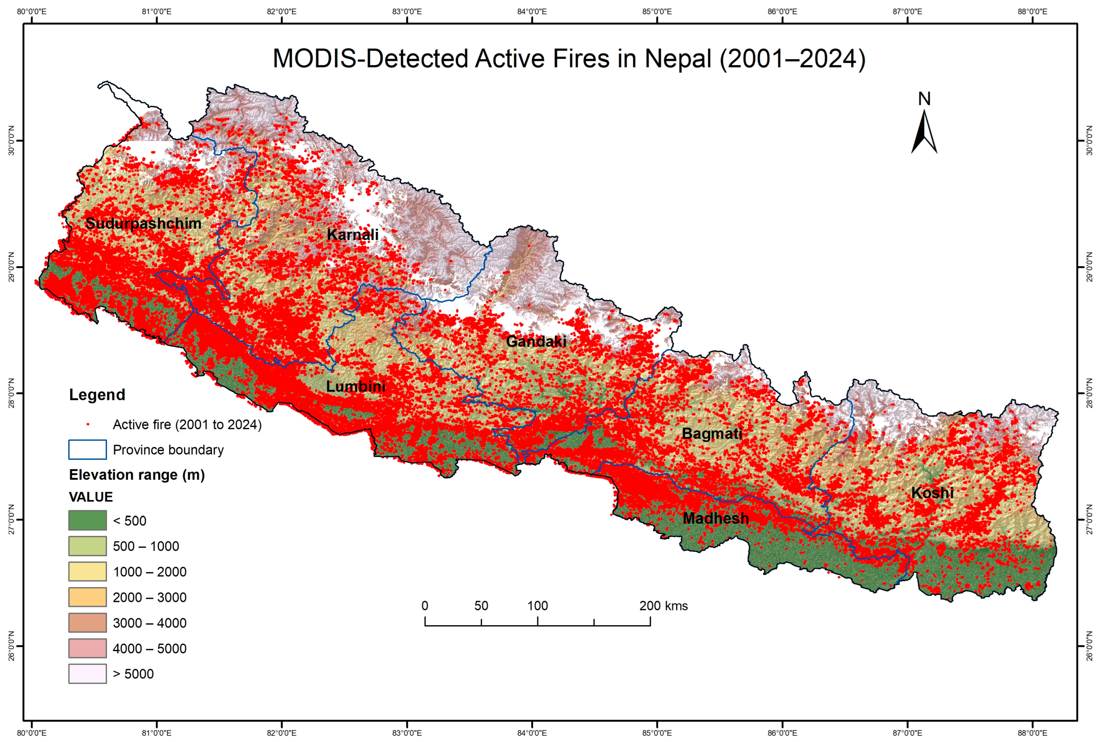
3.1. Long-Term Spatiotemporal Trends in Forest Fire Activity (2001–2024)

The MODIS active fire data for Nepal (Figure 4) reveals notable spatiotemporal variation in forest fire activity over the past two and a half decades, with a general trend of increasing fire incidents in recent years. Each red dot on the map represents an active fire detected between 2001 and 2024. The spatial distribution highlights a concentration of fires along the mid-hill and lower mountain regions, particularly within the provinces of Lumbini, Gandaki, Karnali, and Bagmati. While the Terai plains and lower elevation zones (<1000 m) also experience substantial fire activity, the intensity is relatively lower compared to the mid-elevation areas.
A distinct seasonal pattern emerges from the data, with the majority of fires occurring during the pre-monsoon months of March and April. These two months alone account for approximately 69% of the total fire detections, underscoring the strong link between forest fire occurrence and seasonal climatic conditions. Certain years stand out due to exceptionally high fire counts, such as 2016 (5740 fires), 2021 (5812), and 2024 (5106), suggesting the occurrence of intense and widespread fire events. These peaks are likely influenced by a combination of climatic anomalies such as prolonged drought and anthropogenic factors, including land-use changes (Figure 5).
Nepal’s CO2 emissions data have also shown a dramatic increase over the past two decades, rising from ~3 MtCO2 in 2001 to over 16 MtCO2 in 2023, a more than fivefold increase.

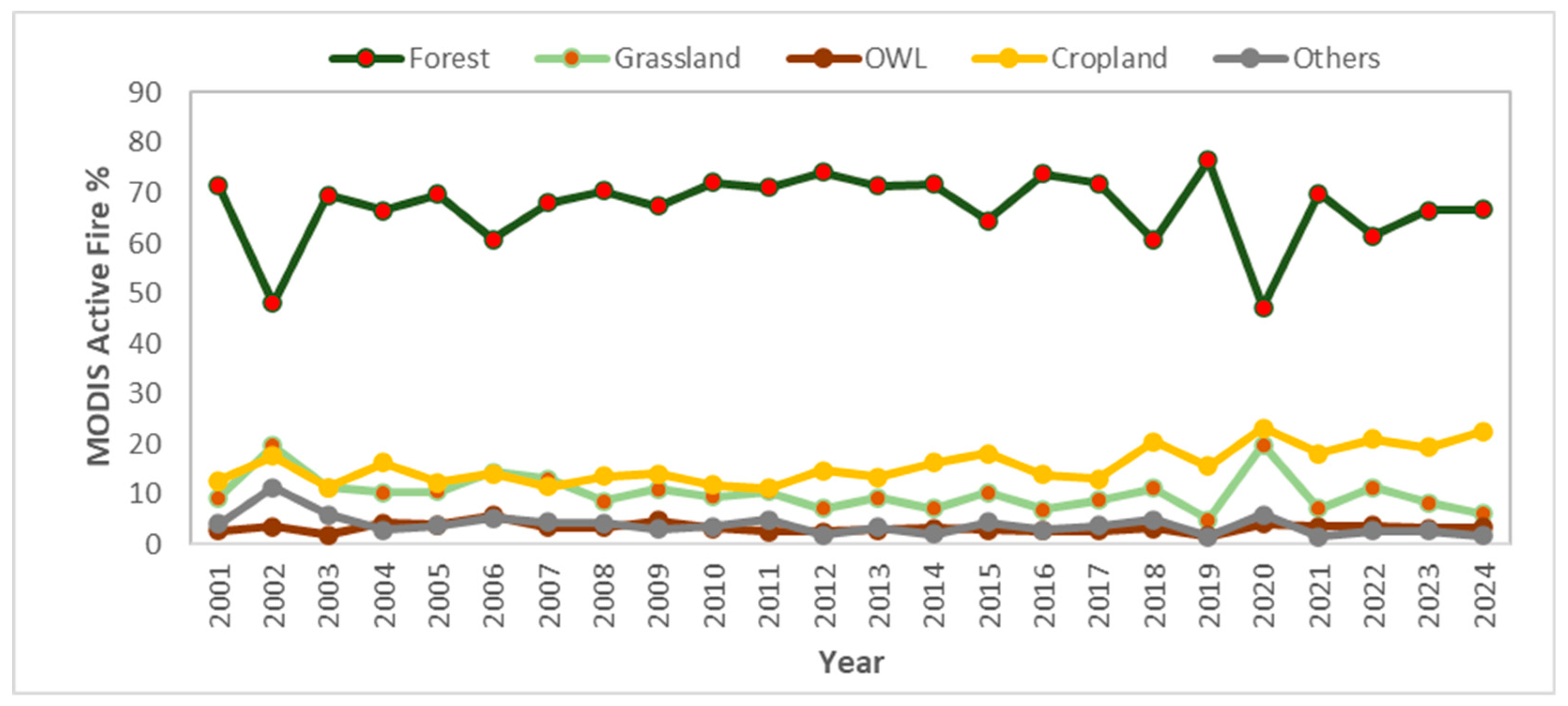
3.2. Spatiotemporal Distribution of Active Fires by Land Cover Type in Nepal (2001–2024)
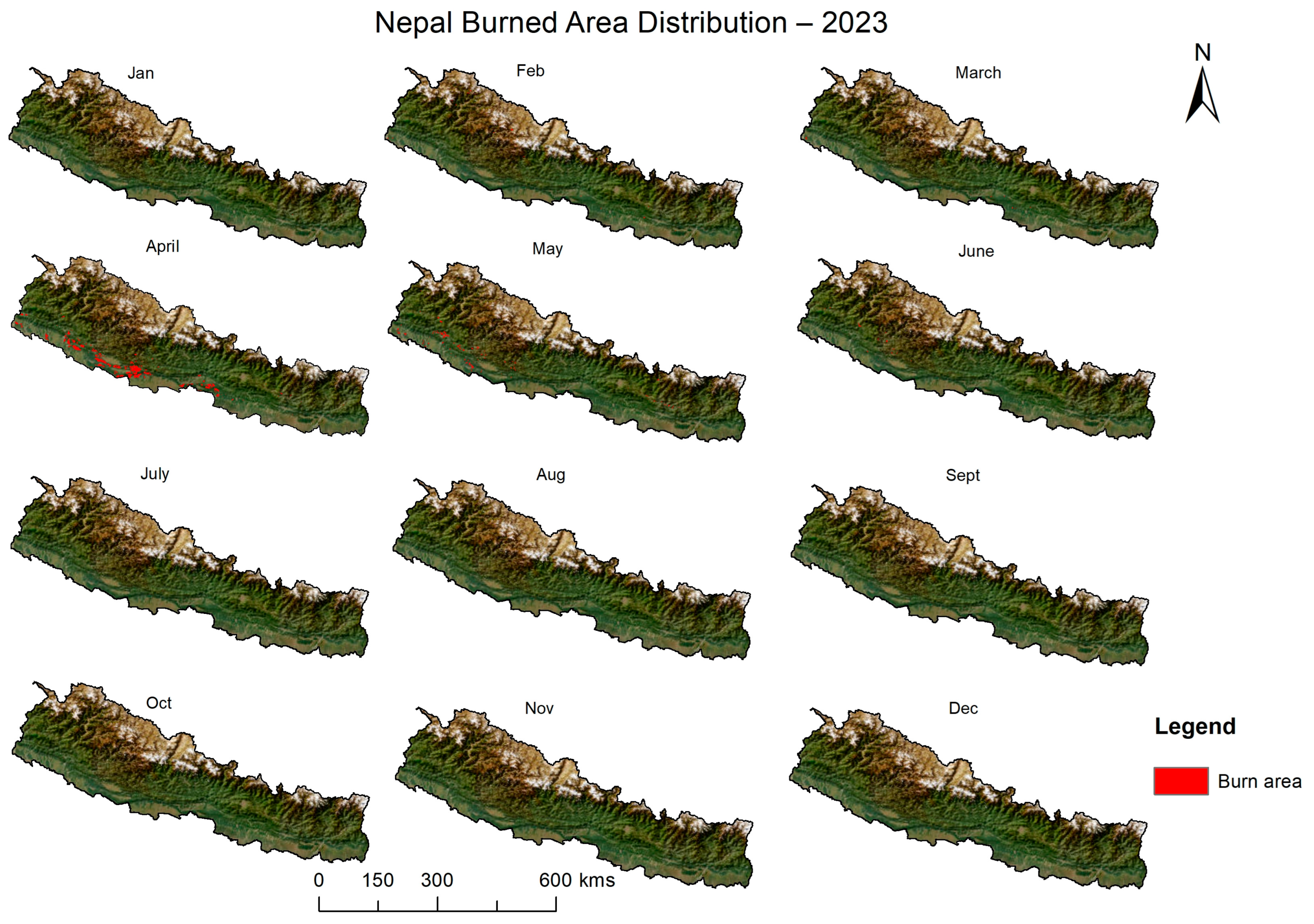
From 2001 to 2024, MODIS active fire data revealed that forests in Nepal consistently experienced the highest proportion of fire incidents, averaging above 65% annually and peaking at 76.5% in 2019. Cropland fires showed a rising trend, increasing from 12.6% in 2001 to over 22% in 2024, with the highest share of 23.2% recorded in 2020 (Figure 6). Grassland fire activity fluctuated considerably, ranging from a low of 4.8% in 2019 to a peak of 19.7% in 2020. Other Wooded Land (OWL) remained relatively stable with low fire occurrence, mostly between 2–5%, with the highest at 5.63% in 2006. The “Others” category (including urban, barren, etc.) showed low but variable fire activity between 1.4% and 11.2%, with the maximum recorded in 2002.

3.3. Burn Area

In April 2023 alone (Figure 7), approximately 204,488 hectares of land in Nepal were affected by fire, as detected by the MODIS MCD64A1 Collection 6 Burned Area Product. This month accounted for the highest fire activity in the year, underscoring the pre-monsoon fire season (March to May) as the most critical period for forest fire occurrence in Nepal. The majority of these burned areas were concentrated in the Terai and Siwalik regions, where dry deciduous forests are highly susceptible to fire during the pre-monsoon season.
An analysis of the annual spatial distribution of burned areas in Nepal reveals that the peak fire season typically occurs in April and May, with April 2023 showing particularly high fire activity. The spatial distribution of burned areas in Nepal for the year 2023, as visualized in Figure 8, reveals a strong concentration of fire activity in the southern lowland regions, primarily the Siwalik Hills and Terai plains, while the high mountains and Himalayan regions remain less affected.

3.4. Fire Weather

This study assessed key fire danger metrics FFMC, ISI, BUI, and FWI, calculated using high-resolution meteorological inputs from the HIWAT system, and adopting the Canadian Fire Weather Index methodology. The analysis, spanning from 10 March to 15 May 2023, incorporates daily maximum and minimum values to capture spatial and temporal variations in modeled fire risk across Nepal’s diverse landscapes.

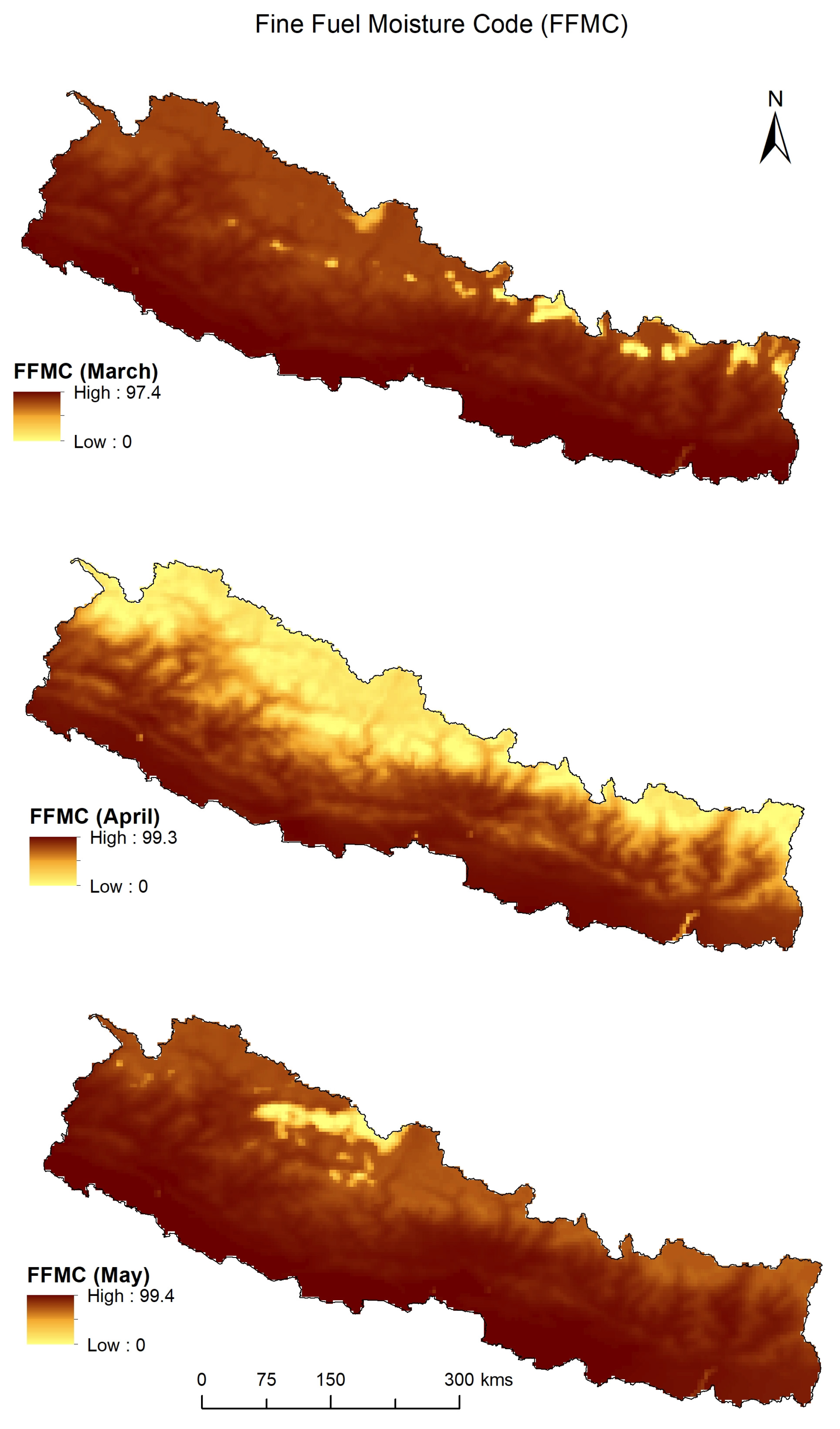
3.4.1. Fine Fuel Moisture Code (FFMC)

FFMC values varied substantially during the analysis period, ranging from a low of 10.10 on 30 April to a maximum of 99.82 on 15 April (Figure 9). FFMC values consistently exceeded 94 throughout April and May, indicating extremely dry fine surface fuels, highly prone to ignition. The lowest FFMC values in mid- and late March (20.78 to 26.39) corresponded with comparatively moister conditions during the early dry season. Peak values observed in mid-April align with the core fire-prone period in Nepal, reflecting critical fire ignition potential.

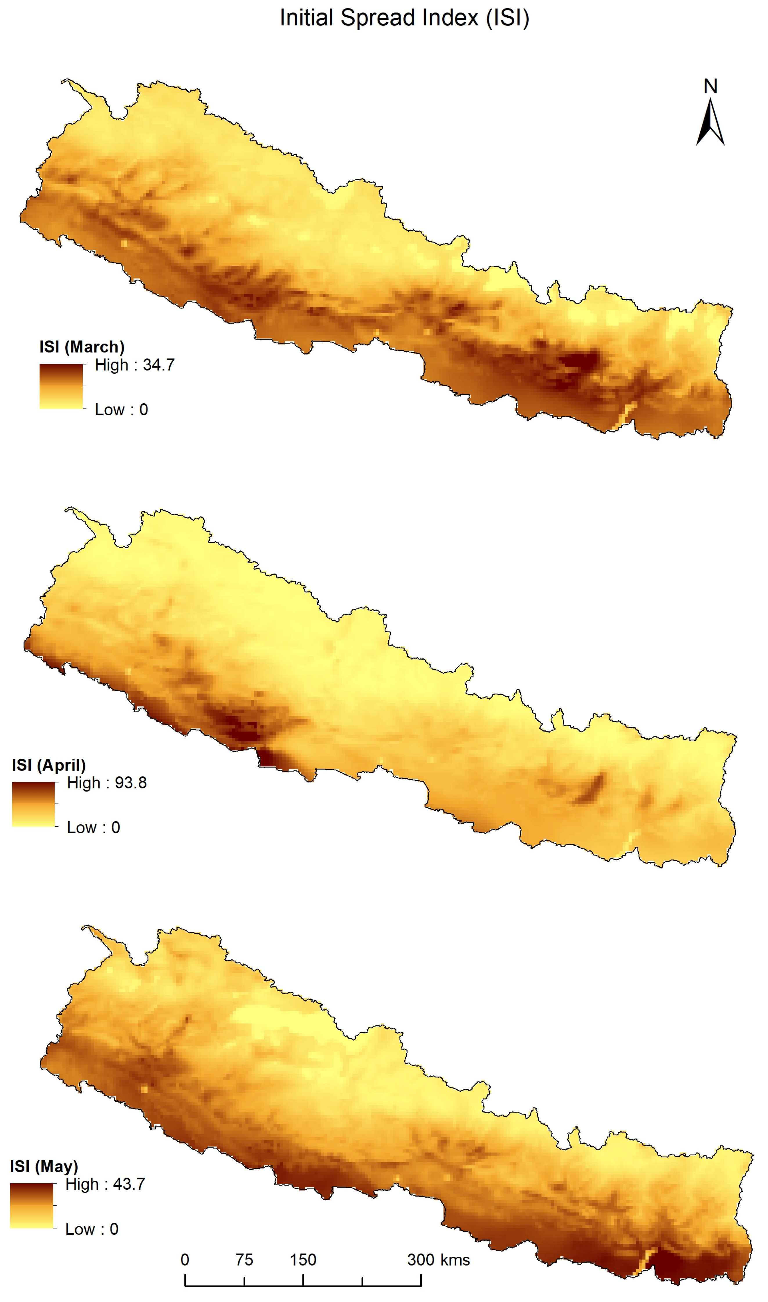
3.4.2. Initial Spread Index (ISI)

The ISI showed significant fluctuations, highlighting changes in wind conditions and fuel dryness. The highest ISI value was 111.56 (15 April), a marked increase compared to early March values (26.99 on 15 March) Figure 10. On multiple days, the ISI exhibited sharp contrasts between high and low values on the same date—such as 93.80 (high) vs. 0.84 (low) on 10 April—suggesting strong spatial heterogeneity in fire spread potential due to topographic and microclimatic influences. Very low ISI values (<0.01) on several days (e.g., 25 March and 30 April) indicate localized conditions with limited fire spread potential.

3.4.3. Buildup Index (BUI)

The BUI, representing the availability of deeper, compact fuels for sustained combustion, increased steadily over time. Starting from 11.02 on 15 March, it peaked at 16.30 on 10 May, indicating progressive drying of organic layers (Figure 11). This temporal trend underscores the cumulative effect of prolonged dry conditions in increasing fire persistence potential. While daily BUI lows remained relatively stable (1.28 to 4.99), the steady increase in daily maxima suggests that once ignited, fires in late April and early May were likely to be more sustained and intense.

3.4.4. Fire Weather Index (FWI)
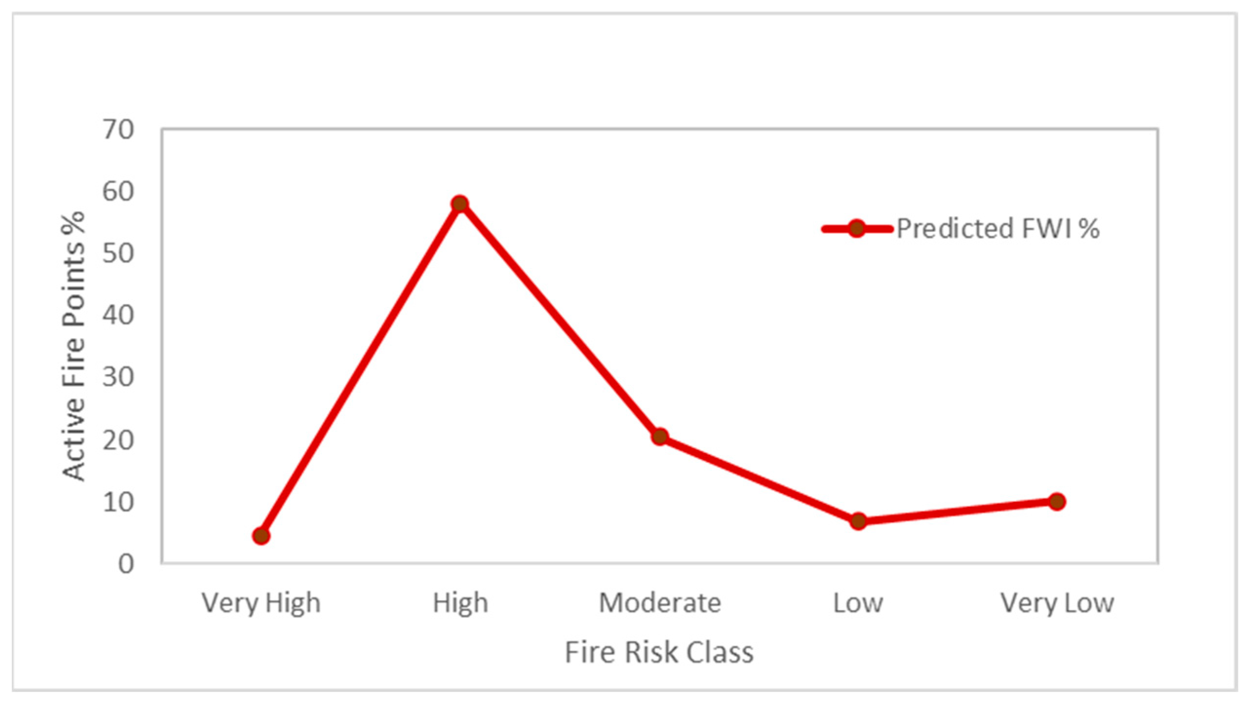
The FWI, a composite measure of overall fire danger, revealed a clear seasonal progression. Early March values were consistently low (25.94 high and ~0.0006 low), reflecting low fire danger conditions. The index increased sharply by mid-April, reaching a peak value of 63.83 on 15 April—corresponding to simultaneous peaks in the FFMC and ISI. Notably, even on the same days, the FWI lows remained near-zero (e.g., 0.02 on 15 April), again pointing to localized variation. After a temporary drop in late April (e.g., 18.52 on 30 April), the FWI values rose again in May, with a secondary high of 43.57 observed on 15 May (Figure 12).

3.5. Validation

A total of 1223 active fire points were compiled from MODIS, VIIRS, and field-recorded fire incidents during the 2023 (April–May) pre-monsoon fire season. These observations were drawn from selected dates across the core fire-prone period: (10, 15) March, (1, 5, 10, 15, 20, 25, 30) April, and (10, 15) May.
This revealed that the majority of active fire detections aligned with elevated fire danger classifications predicted by the FWI model. Specifically, around 58% of the fire points fell within areas categorized as High fire danger, followed by 20.44% in Moderate and 4.58% in Very High fire danger zones (Figure 13). In contrast, 6.87% of fire points were located in Low, and 10.06% in Very Low danger areas.
Overall, more than 80% of the observed fire incidents were captured within the Moderate to Very High danger categories, demonstrating that the FWI model, driven by high-resolution HIWAT meteorological forecasts, effectively identified regions with elevated fire potential.

4. Discussion

This study presents Nepal’s first operational early fire risk prediction system, tailored to the complex terrain and socio-ecological context of the Hindu Kush Himalaya (HKH) region. By integrating the Canadian Fire Weather Index (FWI) with high-resolution meteorological forecasts from the HIWAT platform and validated against MODIS, VIIRS, and ground-based fire data, the system demonstrates a significant improvement in spatial and temporal fire danger prediction accuracy. This advancement fills a critical operational gap in the Hindu Kush Himalaya (HKH) region, where early fire warning systems remain underdeveloped despite a clear increase in forest fire frequency, intensity, and unpredictability due to climate change and anthropogenic pressures [42,43,44].
MODIS-derived active fire data revealed consistent spatiotemporal fire patterns, with fire activity peaking during the pre-monsoon season (March–April), particularly in the mid-hills and Siwalik ranges. These fire-prone areas coincide with zones of high fuel accumulation and ignition likelihood, often exacerbated by slash-and-burn practices, intentional fires, and prolonged droughts [9,45,46,47,48]. In April 2023 alone, over 200,000 hectares were burned—one of the highest monthly totals recorded in recent years—underscoring the urgency for near-real-time fire forecasting tools that support pre-emptive mitigation actions.
The FWI model’s components—the Fine Fuel Moisture Code (FFMC), Initial Spread Index (ISI), and Buildup Index (BUI)—effectively captured the seasonal fire dynamics. Elevated FFMC values during April and May indicated the presence of highly flammable fine fuels, while concurrent increases in the ISI and BUI reflected intensifying fire spread potential due to drying conditions and wind effects. The composite FWI peaked in mid-April, coinciding with widespread fire detections, reinforcing its utility as a responsive indicator of landscape-scale fire danger [49,50].
Model validation using both satellite-based active fire products (MODIS and VIIRS) and ground-based fire records confirmed the system’s predictive accuracy. Over 80% of observed fires occurred within Moderate to Very High danger zones, as classified by the FWI, demonstrating strong alignment between forecasted risk and actual fire occurrence. Approximately 17% of fire points fell within Low or Very Low danger zones, which may reflect sub-daily weather variability, microclimatic effects, or ignition from local anthropogenic sources not captured in coarser-scale model inputs [20,51].
Building on this, Sapkota et al. [52] further demonstrated that incorporating diverse variables—including meteorological, topographical, anthropogenic, locational, and vegetation data—can significantly enhance forest fire prediction accuracy. Their evaluation of multiple machine learning algorithms found that the Random Forest model outperformed others, achieving over 88% prediction accuracy. These findings suggest that integrating such variables and machine learning methods into Nepal’s operational FWI framework could further improve its predictive performance and granularity.
Compared to static or low-resolution fire danger assessments, this system enables dynamic, spatially explicit, and near-real-time forecasting through a web-based platform that automates data ingestion, processing, and dissemination. This architecture improves decision-making capabilities for national agencies, local governments, and community-based organizations. Its modular design and reliance on globally accepted indices such as the FWI also make it adaptable for other HKH countries facing similar bioclimatic and institutional challenges [11,13,52].
Nevertheless, several limitations remain. First, the system currently relies primarily on meteorological predictors and does not incorporate live fuel moisture data, vegetation health indices, or human-induced ignition likelihood, all of which could refine fire risk estimates [53,54]. Second, although HIWAT offers 4 km resolution forecasts, Nepal’s rugged terrain induces microclimatic heterogeneity that may not be fully resolved at this scale. Incorporating finer-scale weather inputs or topographic corrections could enhance model accuracy in complex mountainous regions [55]. Third, the spatial representativeness of ground validation data is uneven, especially in remote or high-altitude regions where fire events may be underreported.
Future improvements should focus on the integration of multi-sensor Earth Observation (EO) data (e.g., Sentinel-2, Landsat-9) to monitor vegetation stress, fuel load, and fire severity in near real-time. Advanced modeling techniques, such as machine learning, could enhance the prediction of ignition likelihood by capturing nonlinear interactions among biophysical and socio-economic variables [15,52]. Additionally, community-based monitoring systems—such as those organized by Community Forest User Groups (CFUGs)—offer valuable local knowledge that could inform model calibration and support bottom-up fire preparedness efforts [19,56].
From a policy perspective, this research highlights the need for integrated fire management strategies that combine EO technologies, high-resolution weather forecasting, and local stakeholder engagement. The successful deployment of this early warning system in Nepal sets a precedent for regional adaptation strategies aligned with the Sendai Framework for Disaster Risk Reduction and the Global Framework for Climate Services (GFCS) [57]. The National Disaster Risk Reduction and Management Authority (NDRRMA) and the Department of Forests and Soil Conservation (DoFSC) have begun incorporating the system into pre-fire season planning processes. As forest fires continue to escalate in frequency and intensity under climate change scenarios, predictive systems such as the one introduced here are not only timely but essential for safeguarding biodiversity, livelihoods, and ecological stability in the HKH region.

5. Conclusions

This study presents Nepal’s first operational early fire danger forecasting system, adopted from the Canadian Fire Weather Index (FWI) and enhanced with high-resolution meteorological inputs from the HIWAT platform. Integrating MODIS, VIIRS, and ground-based fire data, the system accurately captures fire risk patterns, with over 80% of observed fires aligning with Moderate to Very High danger zones. The model’s web-based deployment and modular design enhance accessibility, scalability, and real-time decision-making for diverse stakeholders—from national agencies to community forest groups. Its adaptability offers a transferable solution for other data-scarce, mountainous regions across the Hindu Kush Himalaya (HKH) region. However, limitations persist, including the absence of live fuel moisture metrics, anthropogenic ignition data, and the challenge of capturing microclimatic variability in complex terrain. Future improvements should integrate multi-sensor Earth Observation data, dynamic vegetation indices, and socio-economic drivers to enhance predictive accuracy and local relevance.
By developing and validating an operational, region-specific fire forecasting system for a complex mountainous environment, this study fills a critical gap in forest fire risk modeling and provides a practical framework that can be adapted and extended by researchers and practitioners in similar data-limited regions worldwide. Reflecting its operational value, the National Disaster Risk Reduction and Management Authority (NDRRMA) and the Department of Forests and Soil Conservation (DoFSC) have already begun integrating this system into their pre-fire season planning and response strategies. As forest fire risks intensify under climate change, regionally tailored early warning systems such as this are critical for safeguarding ecosystems, biodiversity, and livelihoods across the HKH and similar vulnerable landscapes.

Author Contributions

Conceptualization, S.T. and T.M.; methodology, S.T., H.K.D., K.S. and B.S.; software, S.T., H.K.D., K.S. and B.S.; validation, S.T., H.K.D. and K.S.; formal analysis, S.T. and H.K.D.; data curation, S.T., H.K.D., K.S. and B.S.; writing—original draft preparation, S.T., T.M. and H.K.D.; writing—review and editing, S.T., T.M. and H.K.D.; visualization, S.T., T.M. and H.K.D.; supervision, T.M., A.A. and B.B. All authors have read and agreed to the published version of the manuscript.

Funding

This research received no external funding.

Data Availability Statement

The data presented in this study are available on request.

Conflicts of Interest

The authors declare no conflict of interest.

References

  1. Jones, M.W.; Veraverbeke, S.; Andela, N.; Doerr, S.H.; Kolden, C.; Mataveli, G.; Pettinari, M.L.; Le Quéré, C.; Rosan, T.M.; van der Werf, G.R.; et al. Global rise in forest fire emissions linked to climate change in the extratropics. Science 2024, 386, eadl5889. [Google Scholar] [CrossRef] [PubMed]
  2. Abatzoglou, J.T.; Williams, A.P. Impact of anthropogenic climate change on wildfire across western US forests. Proc. Natl. Acad. Sci. USA 2016, 113, 11770–11775. [Google Scholar] [CrossRef] [PubMed]
  3. Flannigan, M.D.; Krawchuk, M.A.; de Groot, W.J.; Wotton, B.M.; Gowman, L.M. Implications of changing climate for global wildland fire. Int. J. Wildland Fire 2009, 18, 483–507. [Google Scholar] [CrossRef]
  4. Bowman, D.M.J.S.; Balch, J.K.; Artaxo, P.; Bond, W.J.; Carlson, J.M.; Cochrane, M.A.; D’Antonio, C.M.; DeFries, R.S.; Doyle, J.C.; Harrison, S.P.; et al. Fire in the Earth System. Science 2009, 324, 481–484. [Google Scholar] [CrossRef]
  5. Chaudhary, S.; Nepal, S.; Hussain, A.; Bhuchar, S. Safeguarding the third pole: Problems, challenges, and possible solutions in the Hindu Kush Himalaya. In Safeguarding Mountain Social-Ecological Systems; Elsevier: Amsterdam, The Netherlands, 2024; Volume 2, pp. 271–280. [Google Scholar]
  6. ICIMOD. Water, Ice, Society, and Ecosystems in the Hindu Kush Himalaya: An Outlook; Wester, P., Chaudhary, S., Chettri, N., Jackson, M., Maharjan, A., Nepal, S., Steiner, J.F., Eds.; ICIMOD: Lalitpur, Nepal, 2023. [Google Scholar] [CrossRef]
  7. Wester, P.; Rathore, B.M.S.; Vasily, L.A.; Sharma, E.; Molden, D. The Hindu Kush Himalaya Call to Action: Sustaining Mountain Environments and Improving Livelihoods. Mt. Res. Dev. 2020, 40, P1–P4. [Google Scholar] [CrossRef]
  8. Acharya, G.; Shrestha, S.; Poudel, S.; Paudel, S.R. Climate change challenges to meeting the sustainable development goals in the Hindu Kush Himalayan region. Int. J. Environ. Stud. 2024, 81, 531–536. [Google Scholar] [CrossRef]
  9. Wester, P.; Mishra, A.; Mukherji, A.; Shrestha, A.B. The Hindu Kush Himalaya Assessment: Mountains, Climate Change, Sustainability and People; Springer Nature: Berlin/Heidelberg, Germany, 2019; p. 627. [Google Scholar]
  10. Wang, S.W.; Lim, C.-H.; Lee, W.-K. A review of forest fire and policy response for resilient adaptation under changing climate in the Eastern Himalayan region. For. Sci. Technol. 2021, 17, 180–188. [Google Scholar] [CrossRef]
  11. Thapa, S.; Chitale, V.S.; Pradhan, S.; Shakya, B.; Sharma, S.; Regmi, S.; Bajracharya, S.; Adhikari, S.; Dangol, G.S. Forest Fire Detection and Monitoring. In Earth Observation Science and Applications for Risk Reduction and Enhanced Resilience in Hindu Kush Himalaya Region; Bajracharya, B., Thapa, R.B., Matin, M.A., Eds.; Springer: Cham, Switzerland, 2021. [Google Scholar] [CrossRef]
  12. Xu, J.; Grumbine, R.E.; Shrestha, A.; Eriksson, M.; Yang, X.; Wang, Y.; Wilkes, A. The melting Himalayas: Cascading effects of climate change on water, biodiversity, and livelihoods. Conserv. Biol. 2009, 23, 520–530. [Google Scholar] [CrossRef]
  13. Bhattarai, N.; Dahal, S.; Thapa, S.; Pradhananga, S.; Karky, B.S.; Rawat, R.S.; Windhorst, K.; Watanabe, T.; Thapa, R.B.; Avtar, R. Forest Fire in the Hindu Kush Himalayas: A Major Challenge for Climate Action. J. For. Livelihood 2022, 21, 14–31. [Google Scholar] [CrossRef]
  14. Mishra, B.; Panthi, S.; Poudel, S.; Ghimire, B.R. Forest fire pattern and vulnerability mapping using deep learning in Nepal. Fire Ecol. 2023, 19, 3. [Google Scholar] [CrossRef]
  15. Adhikari, G.; Joshi, K.P.; Chad, D.; Ghimire, A.; Mahara, S. Spatial Dynamics and Risk Mapping of Forest Fires in Madhesh Province, Nepal: A Multi-Criteria Decision Approach. Environ. Nat. Resour. J. 2025, 23, 80–94. [Google Scholar] [CrossRef]
  16. Joshi, G.R.; Rijal, K.; Bhandari, R.; Sapkota, R.P.; Dhital, N.B. A Review of Implementation of Policy Instruments on Forests Fire in Nepal. J. For. Environ. Sci. 2024, 40, 167–179. [Google Scholar]
  17. Paudel, G.; Pandey, K.; Lamsal, P.; Bhattarai, A.; Bhattarai, A.; Tripathi, S. Geospatial forest fire risk assessment and zoning by integrating MaxEnt in Gorkha District, Nepal. Heliyon 2024, 10, e31305. [Google Scholar] [CrossRef] [PubMed]
  18. Department of Forest Research and Survey (DFRS). Annual Forest Fire Report 2023; Ministry of Forests and Environment: Kathmandu, Nepal, 2023.
  19. FRTC. National Land Cover Monitoring System of Nepal, 2020–2022; Forest Research and Training Centre (FRTC): Kathmandu, Nepal, 2024.
  20. Parajuli, A.; Gautam, A.P.; Sharma, S.; Lamichhane, P.; Sharma, G.; Bist, B.S.; Aryal, U.; Basnet, R. A Strategy for involving community forest managers in effective forest fire management in Nepal. Banko Janakari 2022, 32, 41–51. [Google Scholar] [CrossRef]
  21. Chuvieco, E.; Mouillot, F.; van der Werf, G.R.; San Miguel, J.; Tanase, M.; Koutsias, N.; García, M.; Yebra, M.; Padilla, M.; Gitas, I.; et al. Historical background and current developments for mapping burned area from satellite Earth observation. Remote Sens. Environ. 2019, 225, 45–64. [Google Scholar] [CrossRef]
  22. Giglio, L.; Schroeder, W.; Justice, C.O. The collection 6 MODIS active fire detection algorithm and fire products. Remote Sens. Environ. 2016, 178, 31–41. [Google Scholar] [CrossRef]
  23. Justice, C.O.; Giglio, L.; Korontzi, S.; Owens, J.; Morisette, J.T.; Roy, D.; Descloitres, J.; Alleaume, S.; Petitcolin, F.; Kaufman, Y. The MODIS fire products. Remote Sens. Environ. 2002, 83, 244–262. [Google Scholar] [CrossRef]
  24. AFDRS, Australian Fire Danger Rating System. (n.d.). Australian Fire Danger Rating System. Available online: https://afdrs.com.au/ (accessed on 17 May 2025).
  25. Zacharakis, I.; Tsihrintzis, V.A. Environmental forest fire danger rating systems and indices around the globe: A review. Land 2023, 12, 194. [Google Scholar] [CrossRef]
  26. Stocks, B.J.; Lynham, T.J.; Lawson, B.D.; Alexander, M.E.; Van Wagner, C.E.; McAlpine, R.S.; Dubé, D.E. Canadian Forest Fire Danger Rating System: An Overview. For. Chron. 1989, 65, 258–265. [Google Scholar] [CrossRef]
  27. Van Wagner, C.; Forest, P. Development and structure of the canadian forest fireweather index system. In Forestry Technical Report—Canadian Forestry Service; Petawawa National Forestry Institute: Chalk River, ON, Canada, 1987. [Google Scholar]
  28. Deeming, J.E. National Fire-Danger Rating System; Rocky Mountain Forest and Range Experiment Station, Forest Service, US Department of Agriculture: Washington, DC, USA, 1972; Volume 84.
  29. Noble, I.R.; Bary, G.A.V.; Gill, A.M. McArthur’s fire-danger meters expressed as equations. Aust. J. Ecol. 1980, 5, 201–203. [Google Scholar] [CrossRef]
  30. McArthur, A.G. Fire Behaviour in Eucalypt Forests; Commonwealth of Australia Forestry and Timber Bureau: Canberra, Australia, 1967. [Google Scholar]
  31. Vitolo, C.; Di Giuseppe, F.; Krzeminski, B.; San-Miguel-Ayanz, J. A 1980–2018 global fire danger re-analysis dataset for the Canadian Fire Weather Indices. Sci. Data 2019, 6, 190032. [Google Scholar] [CrossRef]
  32. De Jong, M.C.; Wooster, M.J.; Kitchen, K.; Manley, C.; Gazzard, R.; McCall, F.F. Calibration and evaluation of the Canadian Forest Fire Weather Index (FWI) System for improved wildland fire danger rating in the United Kingdom. Nat. Hazards Earth Syst. Sci. 2016, 16, 1217–1237. [Google Scholar] [CrossRef]
  33. ICIMOD. The HKH Call to Action: Building Resilience for Mountains and People; International Centre for Integrated Mountain Development: Kathmandu, Nepal, 2020. [Google Scholar]
  34. Golding, B. Towards the “Perfect” Weather Warning: Bridging Disciplinary Gaps Through Partnership and Communication; Springer Nature: Berlin/Heidelberg, Germany, 2022; p. 270. [Google Scholar]
  35. Case, J.; Mayer, T. High-Impact Weather Assessment Toolkit (HIWAT). In NASA Global Hydrometeorology Resource Center Distributed Active Archive Center (DAAC) Data Set; DATA101: Huntsville, AL, USA, 2023. [Google Scholar]
  36. Giglio, L.; Descloitres, J.; Justice, C.O.; Kaufman, Y.J. An enhanced contextual fire detection algorithm for MODIS. Remote Sens. Environ. 2003, 87, 273–282. [Google Scholar] [CrossRef]
  37. Schroeder, W.; Oliva, P.; Giglio, L.; Csiszar, I.A. The New VIIRS 375 m active fire detection data product: Algorithm description and initial assessment. Remote Sens. Environ. 2014, 143, 85–96. [Google Scholar] [CrossRef]
  38. Csiszar, I.; Schroeder, W.; Giglio, L.; Ellicott, E.; Vadrevu, K.P.; Justice, C.O.; Wind, B. Active Fires from the Suomi NPP Visible Infrared Imaging Radiometer Suite: Product Status and First Evaluation Results. J. Geophys. Res. Atmos. 2014, 119, 803–816. [Google Scholar] [CrossRef]
  39. Giglio, L.; Boschetti, L.; Roy, D.P.; Humber, M.L.; Justice, C.O. The Collection 6 MODIS burned area mapping algorithm and product. Remote Sens. Environ. 2018, 217, 72–85. [Google Scholar] [CrossRef]
  40. Wang, Y.; Anderson, K.R.; Suddaby, R.M. Updated Source Code for Calculating Fire Danger Indices in the Canadian Forest Fire Weather Index System; Natural Resources Canada, Canadian Forest Service: Edmonton, AB, Canada, 2015. [Google Scholar]
  41. Wotton, B.M. Interpreting and using outputs from the Canadian Forest Fire Danger Rating System in research applications. Environ. Ecol. Stat. 2009, 16, 107–131. [Google Scholar] [CrossRef]
  42. Nicoletti, G.; Saravia, L.; Momo, F.; Maritan, A.; Suweis, S. The emergence of scale-free fires in Australia. iScience 2023, 26, 106181. [Google Scholar] [CrossRef]
  43. Rodrigues, M.; Zúñiga-Antón, M.; Alcasena, F.; Gelabert, P.; Vega-Garcia, C. Integrating geospatial wildfire models to delineate landscape management zones and inform decision-making in Mediterranean areas. Saf. Sci. 2022, 147, 105616. [Google Scholar] [CrossRef]
  44. Masson-Delmotte, V.; Zhai, P.; Pirani, A.; Connors, S.L.; Péan, C.; Berger, S.; Goldfarb, L.; Gomis, M.I.; Matthews, J.B.R.; Berger, S.; et al. Climate change 2021: The physical science basis. In Contribution of Working Group I to the Sixth Assessment Report of the Intergovernmental Panel on Climate Change; IPCC: Geneva, Switzerland, 2021; Volume 2, p. 2391. [Google Scholar]
  45. Bhujel, K.B.; Sapkota, R.P.; Khadka, U.R. Temporal and Spatial Distribution of Forest Fires and their Environmental and Socio-economic Implications in Nepal. J. For. Livelihood 2022, 21, 1–13. [Google Scholar] [CrossRef]
  46. Laudari, H.K.; Aryal, K.; Maraseni, T.; Pariyar, S.; Pant, B.; Bhattarai, S.; Kaini, T.R.; Karki, G.; Marahattha, A. Sixty-five years of forest restoration in Nepal: Lessons learned and way forward. Land Use Policy 2022, 115, 106033. [Google Scholar] [CrossRef]
  47. Rusk, J.; Maharjan, A.; Tiwari, P.; Chen, T.-H.K.; Shneiderman, S.; Turin, M.; Seto, K.C. Multi-hazard susceptibility and exposure assessment of the Hindu Kush Himalaya. Sci. Total Environ. 2022, 804, 150039. [Google Scholar] [CrossRef] [PubMed]
  48. Dupuy, J.-L.; Fargeon, H.; Martin-StPaul, N.; Pimont, F.; Ruffault, J.; Guijarro, M.; Hernando, C.; Madrigal, J.; Fernandes, P. Climate change impact on future wildfire danger and activity in southern Europe: A review. Ann. For. Sci. 2020, 77, 35. [Google Scholar] [CrossRef]
  49. Uddin, K.; Matin, M.A.; Khanal, N.; Maharjan, S.; Bajracharya, B.; Tenneson, K.; Poortinga, A.; Quyen, N.H.; Aryal, R.R.; Saah, D.; et al. Regional land cover monitoring system for Hindu Kush Himalaya. In Earth Observation Science and Applications for Risk Reduction and Enhanced Resilience in Hindu Kush Himalaya Region: A Decade of Experience from SERVIR; Springer: Cham, Switzerland, 2021; pp. 103–125. [Google Scholar]
  50. Shrestha, A.B.; Bajracharya, S.R.; Sharma, A.R.; Khanal, N.R. Climate change and disaster impacts in the Hindu Kush Himalaya. Int. J. Environ. Res. Public Health 2018, 15, 2583. [Google Scholar]
  51. Matin, M.A.; Chitale, V.S.; Murthy, M.S.R.; Uddin, K.; Bajracharya, B.; Pradhan, S. Understanding forest fire patterns and risk in Nepal using remote sensing, geographic information system and historical fire data. Int. J. Wildland Fire 2017, 26, 276–286. [Google Scholar] [CrossRef]
  52. Sapkota, S.; Joshi, K.P.P.; Kuikel, S.; Kuinkel, D.; Bhandari, B.; Wu, Y.; Bing, H.; Marahatta, S.; Aryal, D.; Wang, S.-Y.S.; et al. Advancing wildfire prediction in Nepal using machine learning algorithms. Environ. Res. Commun. 2025, 7, 055003. [Google Scholar] [CrossRef]
  53. Bar, S.; Parida, B.R.; Pandey, A.C.; Kumar, N. Pixel-Based Long-Term (2001–2020) Estimations of Forest Fire Emissions over the Himalaya. Remote Sens. 2022, 14, 5302. [Google Scholar] [CrossRef]
  54. Maraseni, T.N.; Reardon-Smith, K.; Griffiths, G.; Apan, A. Savanna burning methodology for fire management and emissions reduction: A critical review of influencing factors. Carbon Balance Manag. 2016, 11, 25. [Google Scholar] [CrossRef]
  55. Sharma, S.; Pokhrel, A. Challenges in forest fire management in the Himalaya: Experiences from Nepal. Trop. For. 2022, 61, 137–143. [Google Scholar] [CrossRef]
  56. Shrestha, S.; Regmi, S.; Shrestha, S.; Sanyal, S.; Thapa, N.; Dulal, B. Forest Fires in Nepal: The Unseen Threat of Droughts. ICIMOD Blog. Available online: https://blog.icimod.org/cryosphere-water-risks/forest-fires-in-nepal-the-unseen-threat-of-droughts/ (accessed on 31 March 2025).
  57. Pandey, H.P.; Pokhrel, N.P.; Thapa, P.; Paudel, N.S.; Maraseni, T.N. Status and practical implications of forest fire management in Nepal. J. For. Livelihood 2022, 21, 32–45. [Google Scholar] [CrossRef]
Figure 1. Nepal in the HKH region, overlaid with land cover (data source: ICIMOD & FRTC, 2024).
Remotesensing 17 02255 g001
Figure 2. Methodological framework for fire risk prediction in Nepal.
Remotesensing 17 02255 g002
Figure 3. Workflow for computing the Forest Fire Weather Index (FWI) using HIWAT meteorological forecasts (adopted from the Canadian Forest Fire Weather Index System).
Remotesensing 17 02255 g003
Figure 4. Spatial distribution of MODIS active fires (≥50% confidence level) from 2001 to 2024 across the altitudinal range of Nepal. Each red dot represents a single 1 km2 pixel where at least one active fire was detected during the 24-year period. The dense clustering of red points indicates areas with repeated fire activity over time, not continuous or simultaneous burning.
Remotesensing 17 02255 g004
Figure 5. Comparison of CO2 emissions and MODIS active fire detections (2001–2023). CO2 emissions data were obtained from the Global Carbon Atlas, while active fire detections were derived from NASA’s MODIS sensor via the FIRMS (Fire Information for Resource Management System) platform.
Remotesensing 17 02255 g005
Figure 6. This figure shows the percentage share of total MODIS active fire detections across different land cover types in Nepal from 2001 to 2024. Land cover classifications are based on FRTC datasets. The percentages represent each land cover type’s proportion.
Remotesensing 17 02255 g006
Figure 7. Spatial distribution of burned areas in Nepal during April 2023, as detected by the MODIS MCD64A1 Burned Area Product.
Remotesensing 17 02255 g007
Figure 8. MODIS-derived burn area across Nepal from January to December 2023. This map illustrates the spatial distribution of burned areas detected by the MODIS MCD64A1 Collection 6 Product across Nepal throughout the year 2023.
Remotesensing 17 02255 g008
Figure 9. FFMC maps for March, April, and May 2023, showing the seasonal increase in fine fuel dryness across Nepal using HIWAT data.
Remotesensing 17 02255 g009
Figure 10. ISI maps for March, April, and May 2023, illustrating the seasonal rise in fire spread potential across Nepal.
Remotesensing 17 02255 g010
Figure 11. BUI for March, April, and May 2023, depicting the seasonal buildup of combustible fuel across Nepal.
Remotesensing 17 02255 g011
Figure 12. FWI maps for 10 March, 10 April, and 10 May 2023, showing the overall fire danger levels across Nepal derived from HIWAT data.
Remotesensing 17 02255 g012
Figure 13. Validation of predicted fire risk: distribution of active fire points (%) across FWI fire risk classes for the 2023 fire season, showing peak alignment in the High and Moderate categories.
Remotesensing 17 02255 g013
Disclaimer/Publisher’s Note: The statements, opinions and data contained in all publications are solely those of the individual author(s) and contributor(s) and not of MDPI and/or the editor(s). MDPI and/or the editor(s) disclaim responsibility for any injury to people or property resulting from any ideas, methods, instructions or products referred to in the content.

