


Explainable Artificial Intelligence (XAI) for Flood Susceptibility Assessment in Seoul: Leveraging Evolutionary and Bayesian AutoML Optimization


Abstract
1. Introduction
- (1)
- To valuate and compare evolutionary and Bayesian optimization strategies in the context of real-world flood prediction.
- (2)
- To examine the trade-offs between automated and expert-driven pipeline design.
- (3)
- To generate spatially explicit insights into flood susceptibility using explainable ML tools.
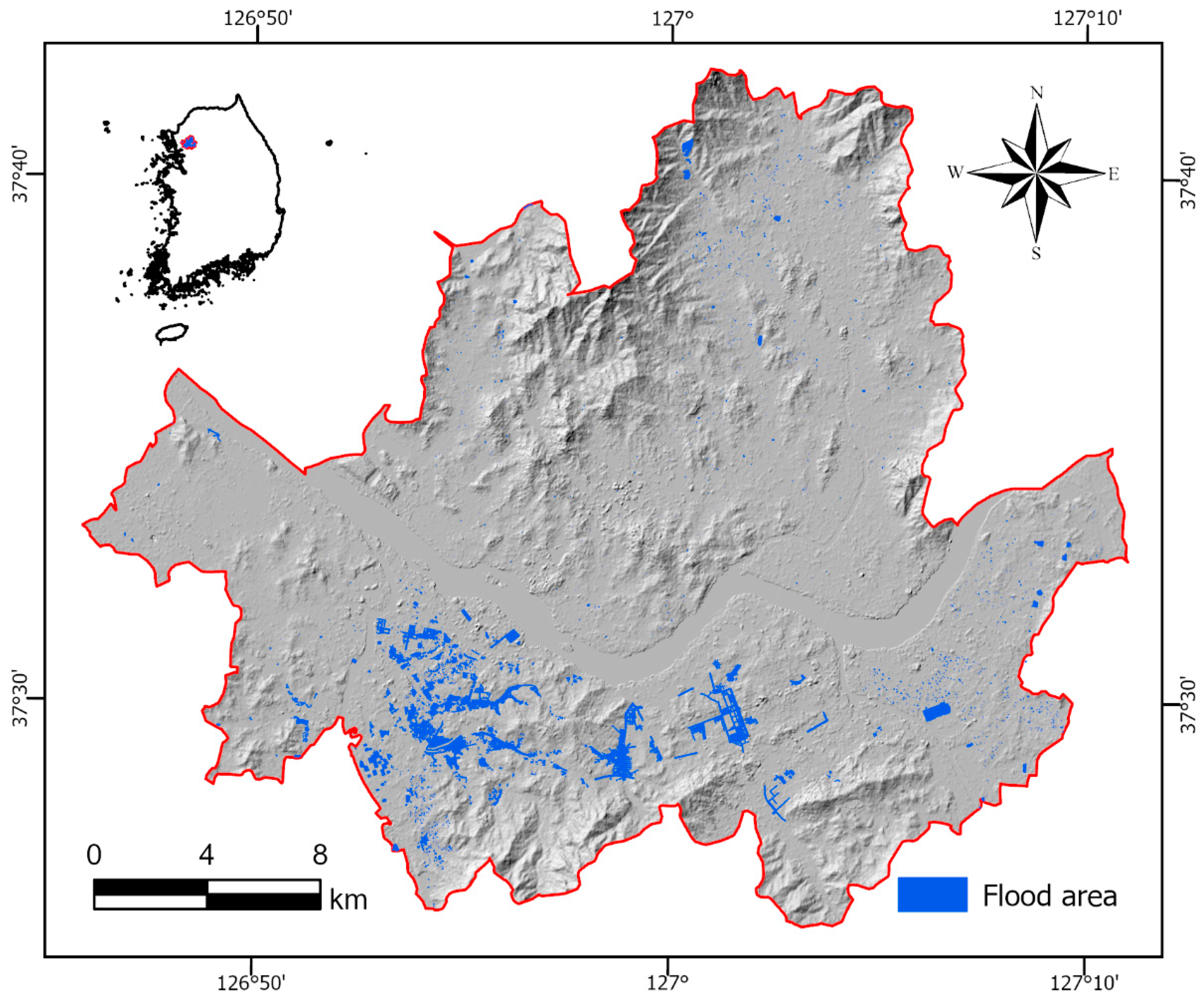
2. Study Area
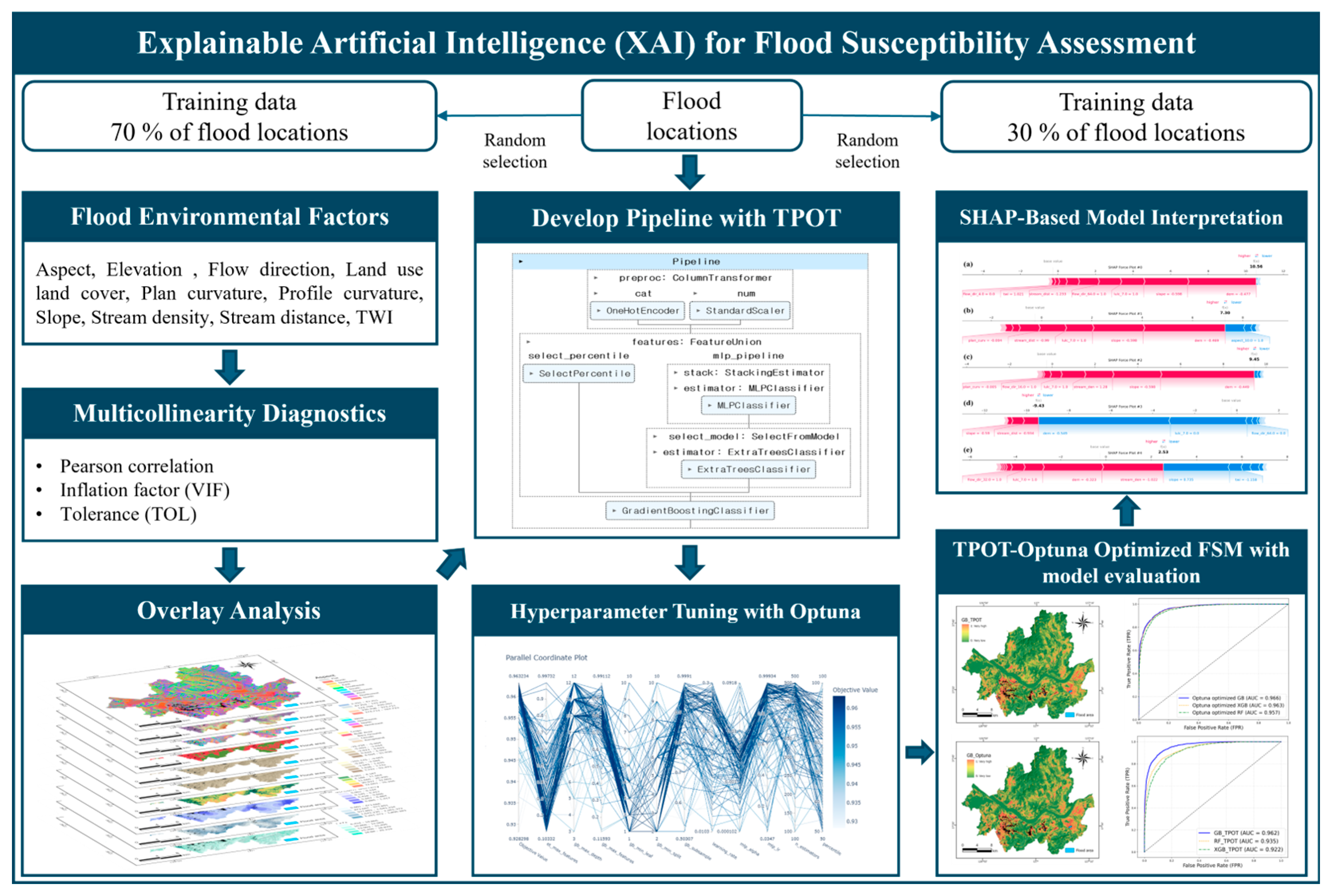
3. Materials and Methods
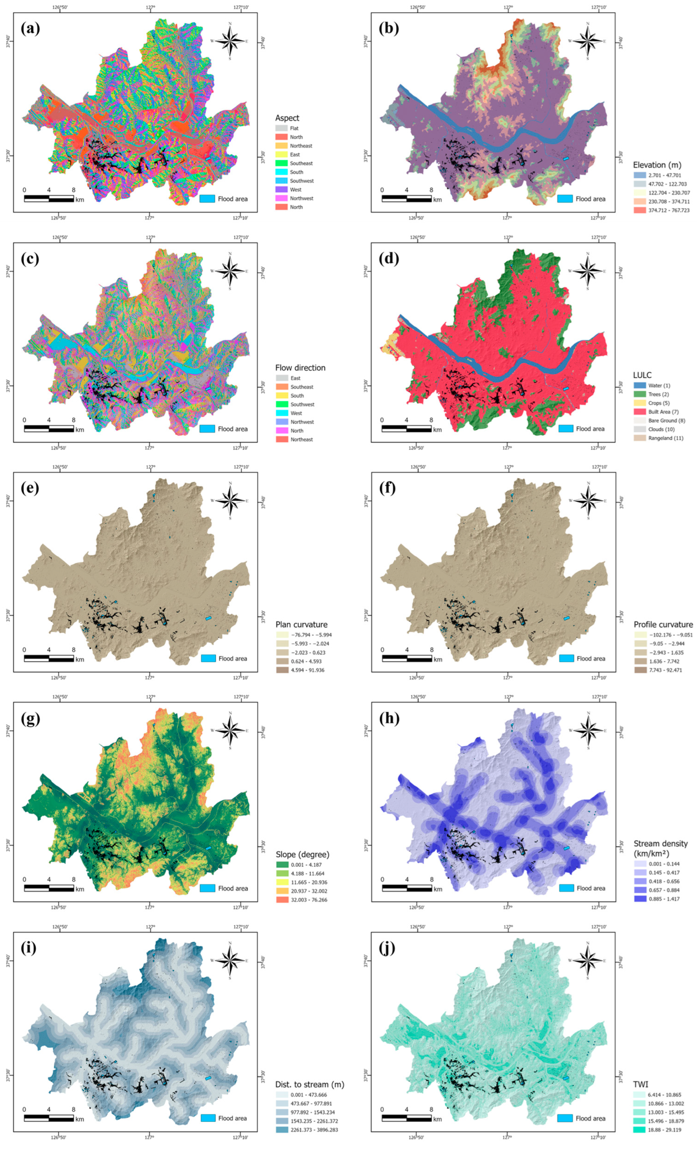
3.1. Spatial Datasets
3.2. Factor Selection
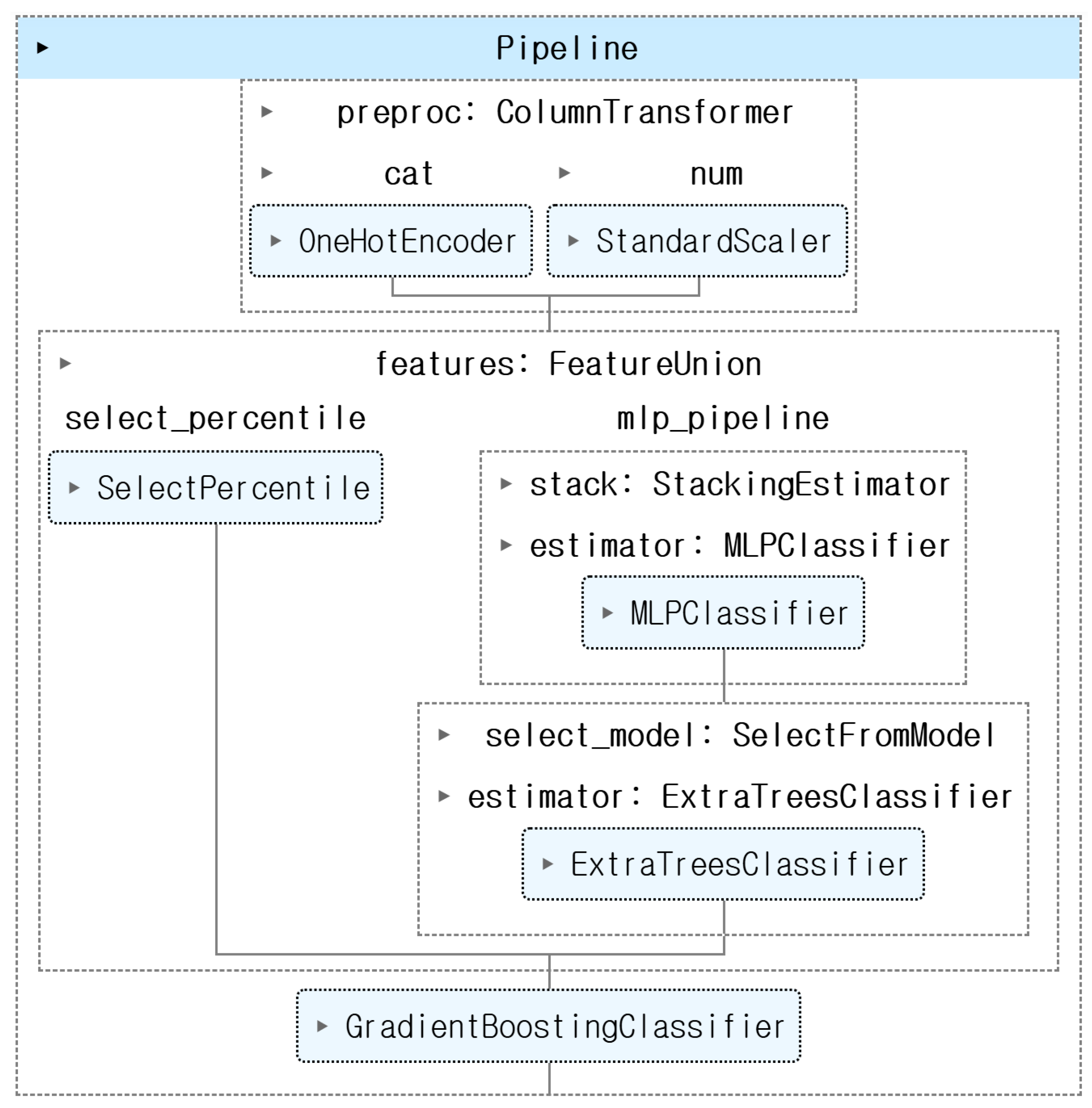
3.3. TPOT for Automated Model Pipeline Optimization
3.4. Optuna for Hyperparameter Tuning
3.5. SHAP for Model Explainability
3.6. Model Evaluation Criteria
4. Results
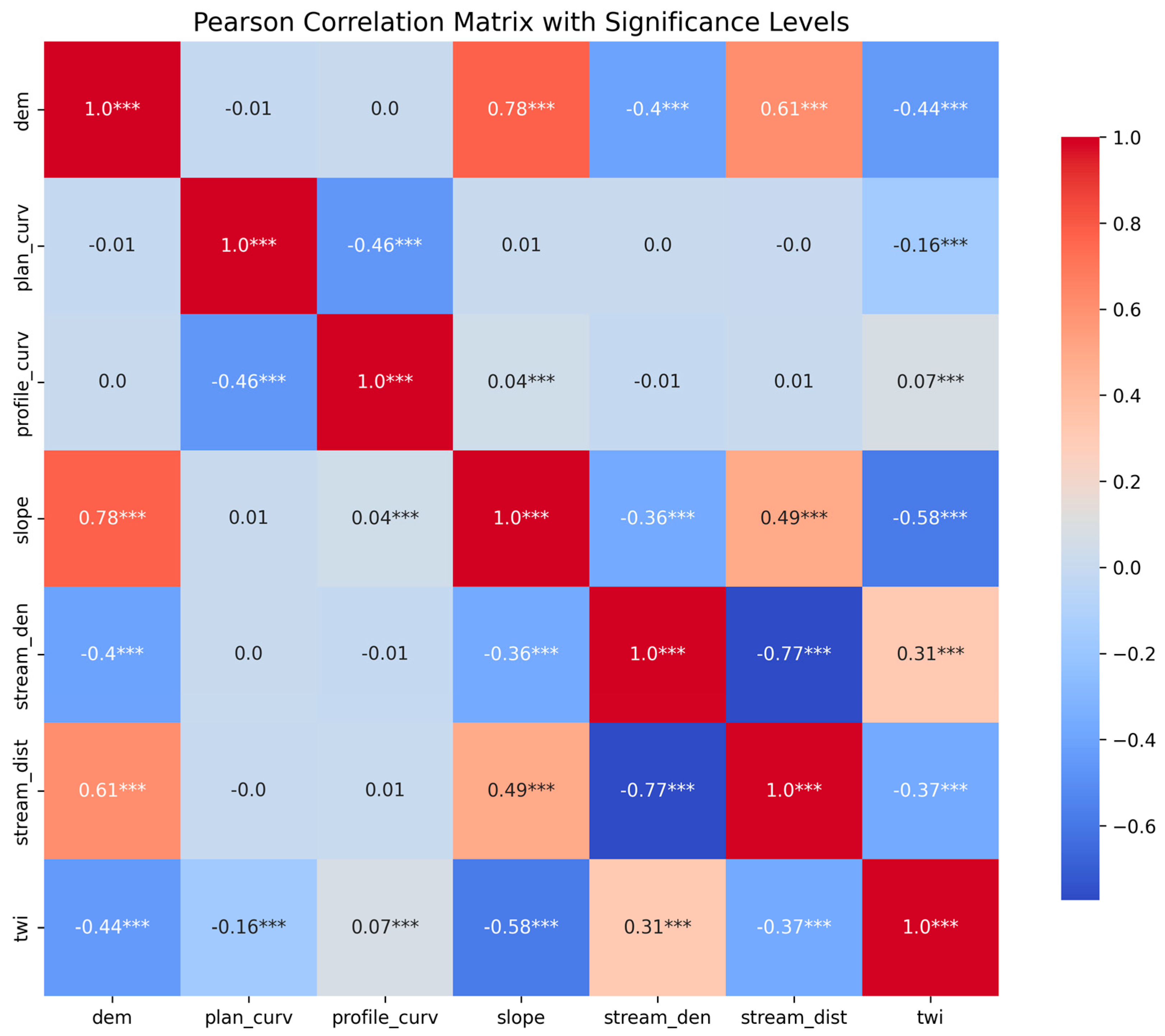
4.1. Correlation and Multi-Collinearity Analysis
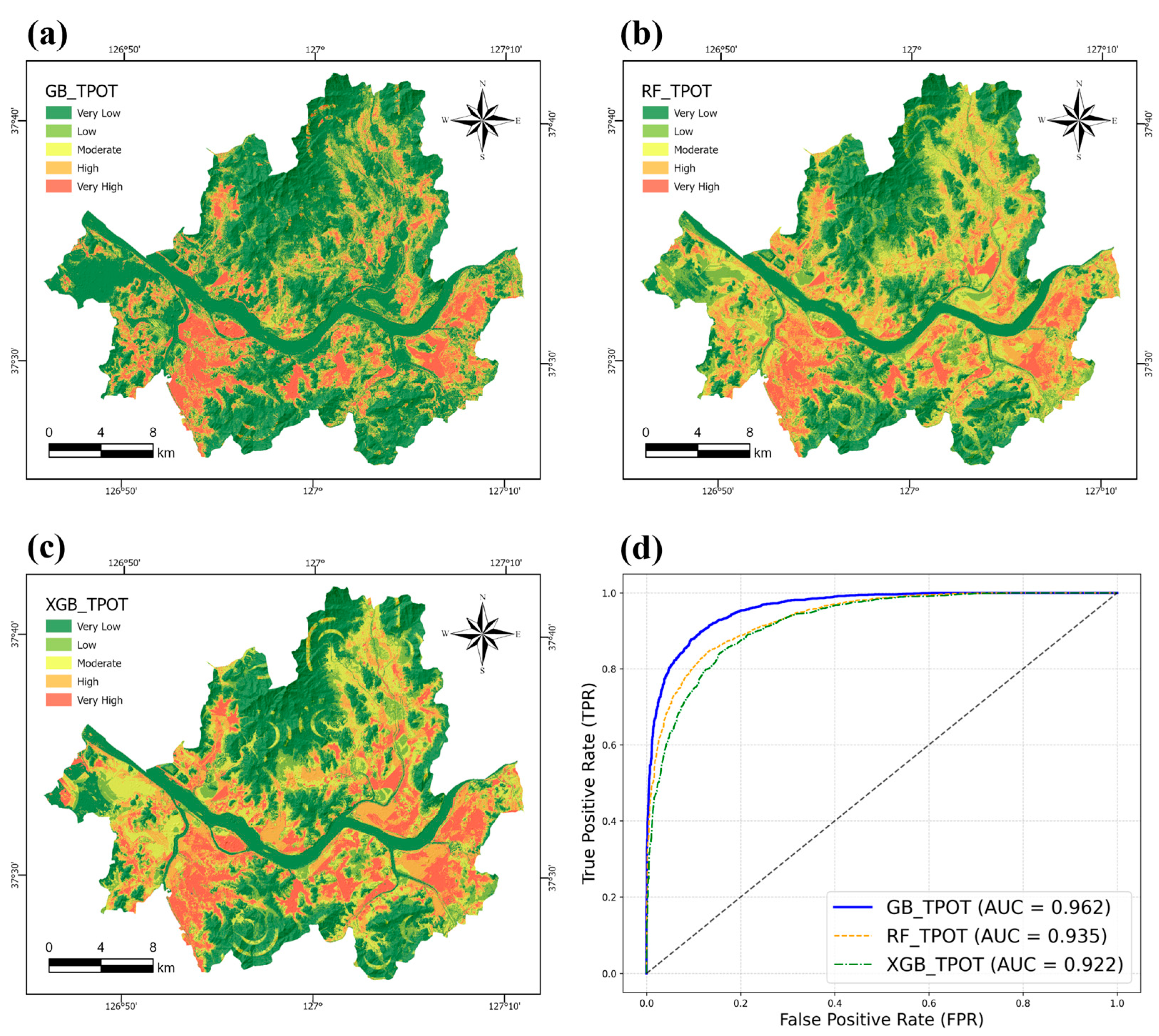
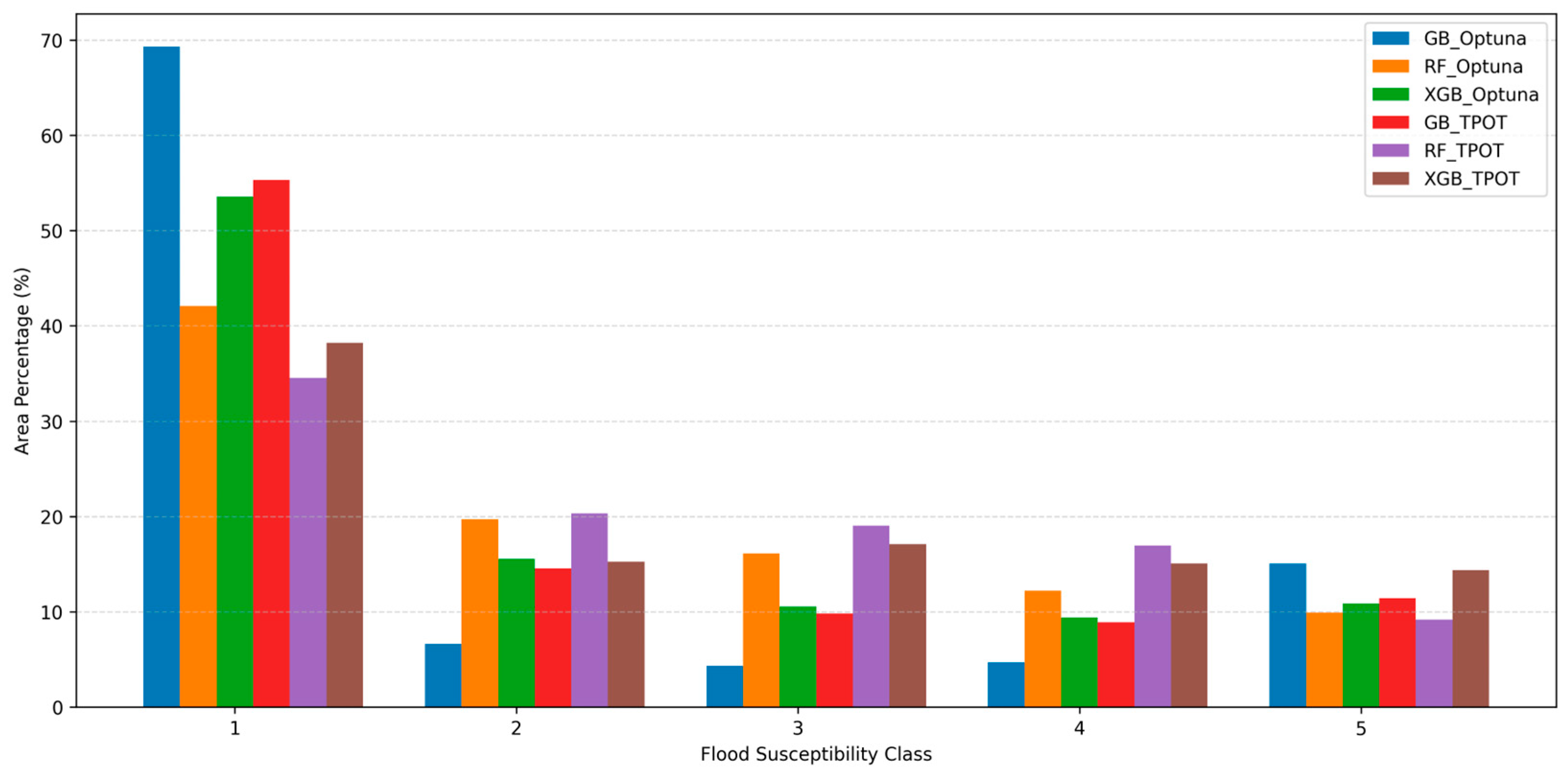
4.2. TPOT-Based Flood Susceptibility Mapping
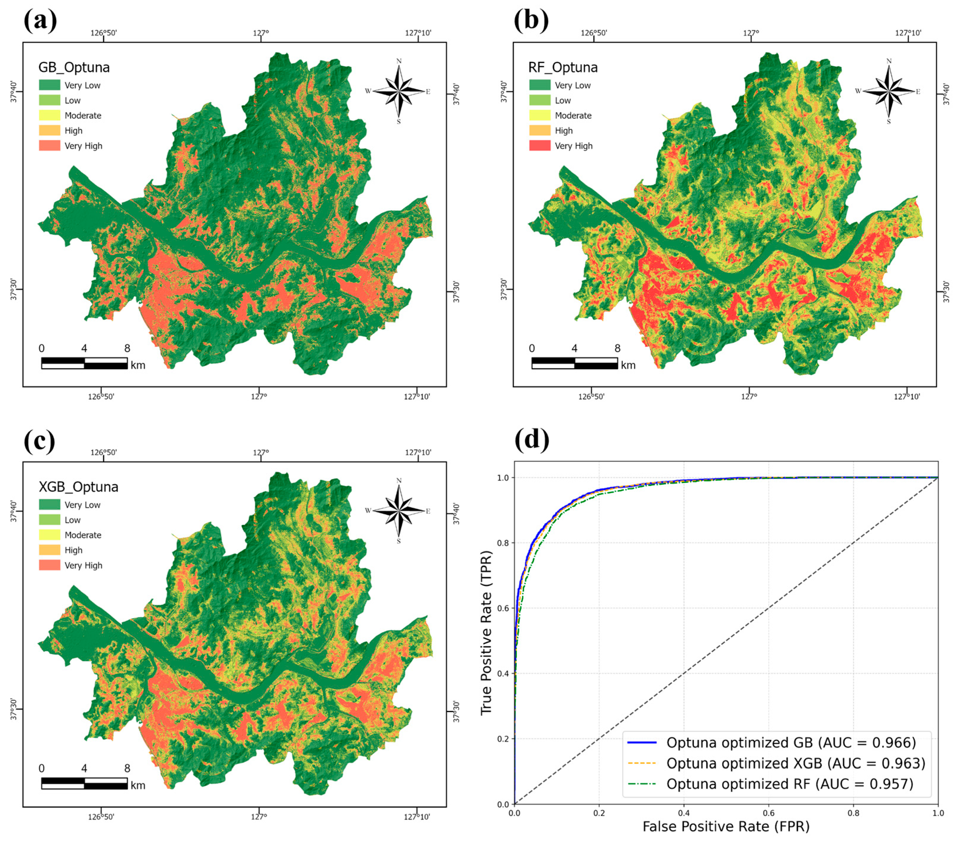
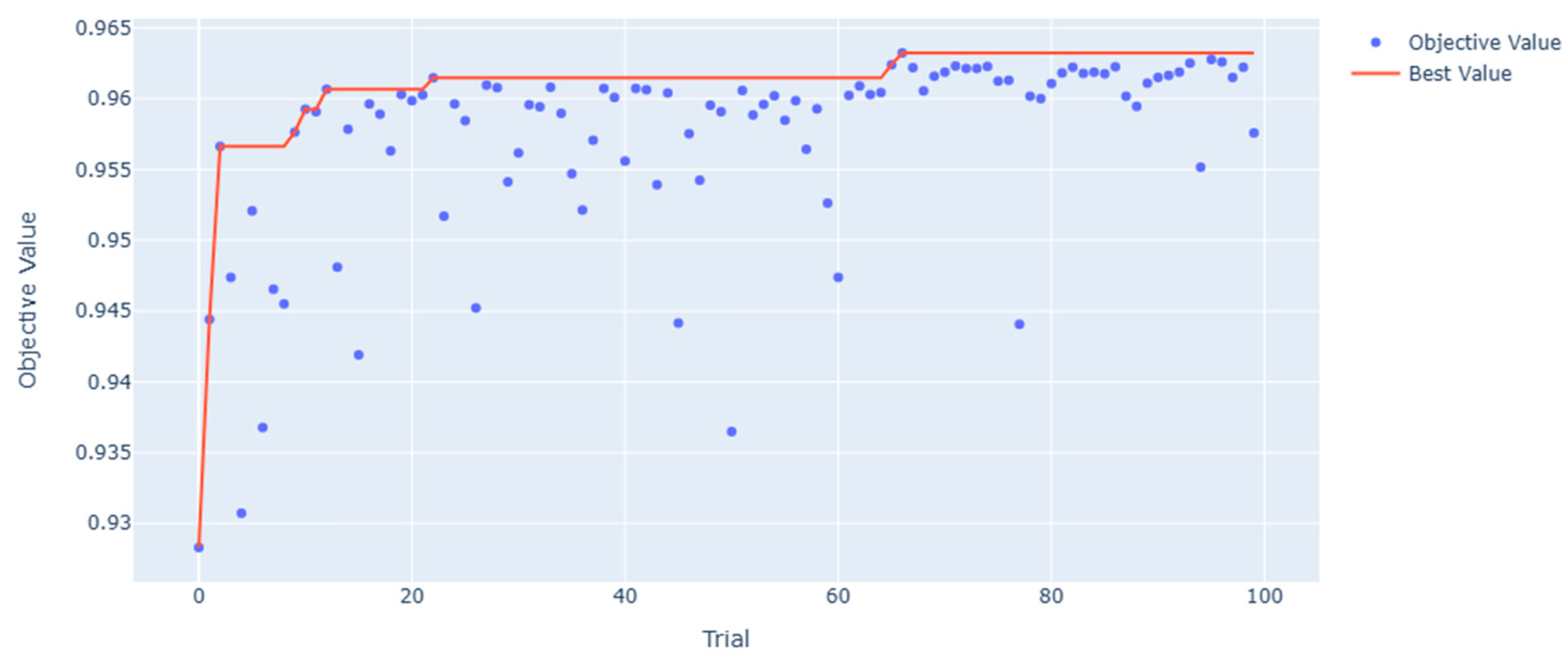
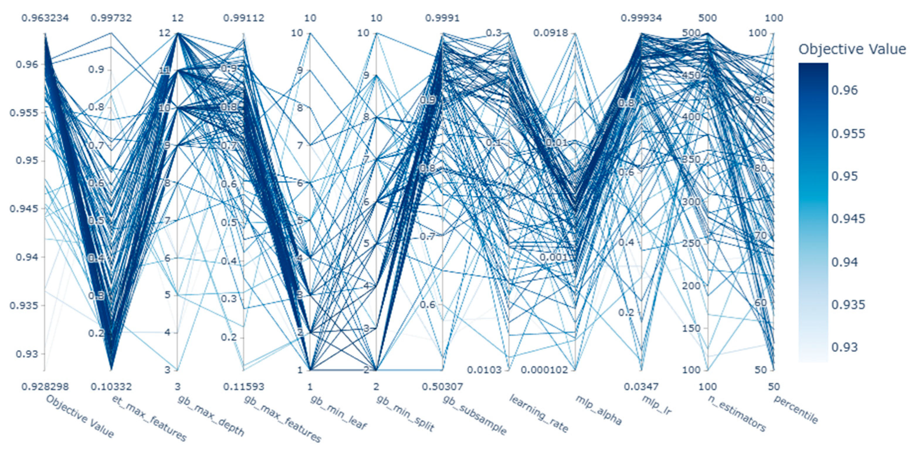
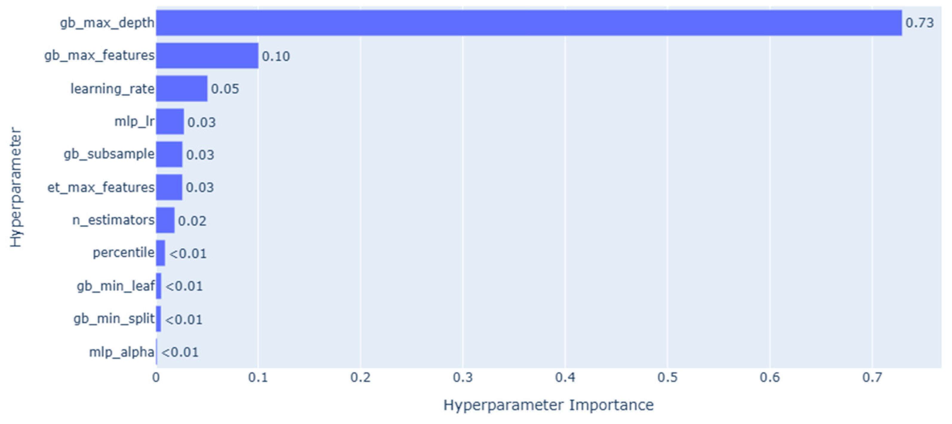
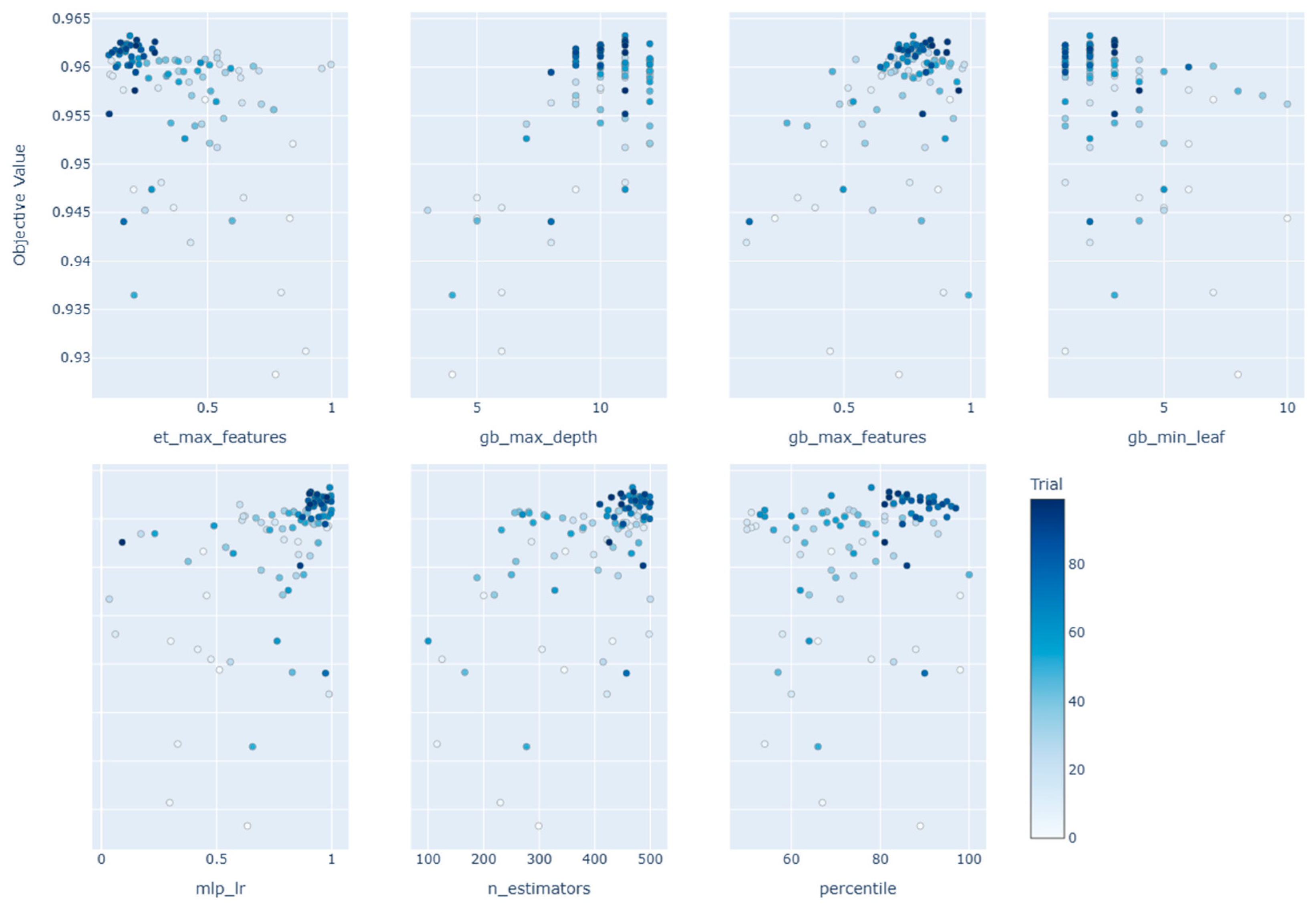
4.3. TPOT-Optuna Enhanced Flood Susceptibility Mapping
4.4. Model Performance
4.5. SHAP-Based Model Interpretation
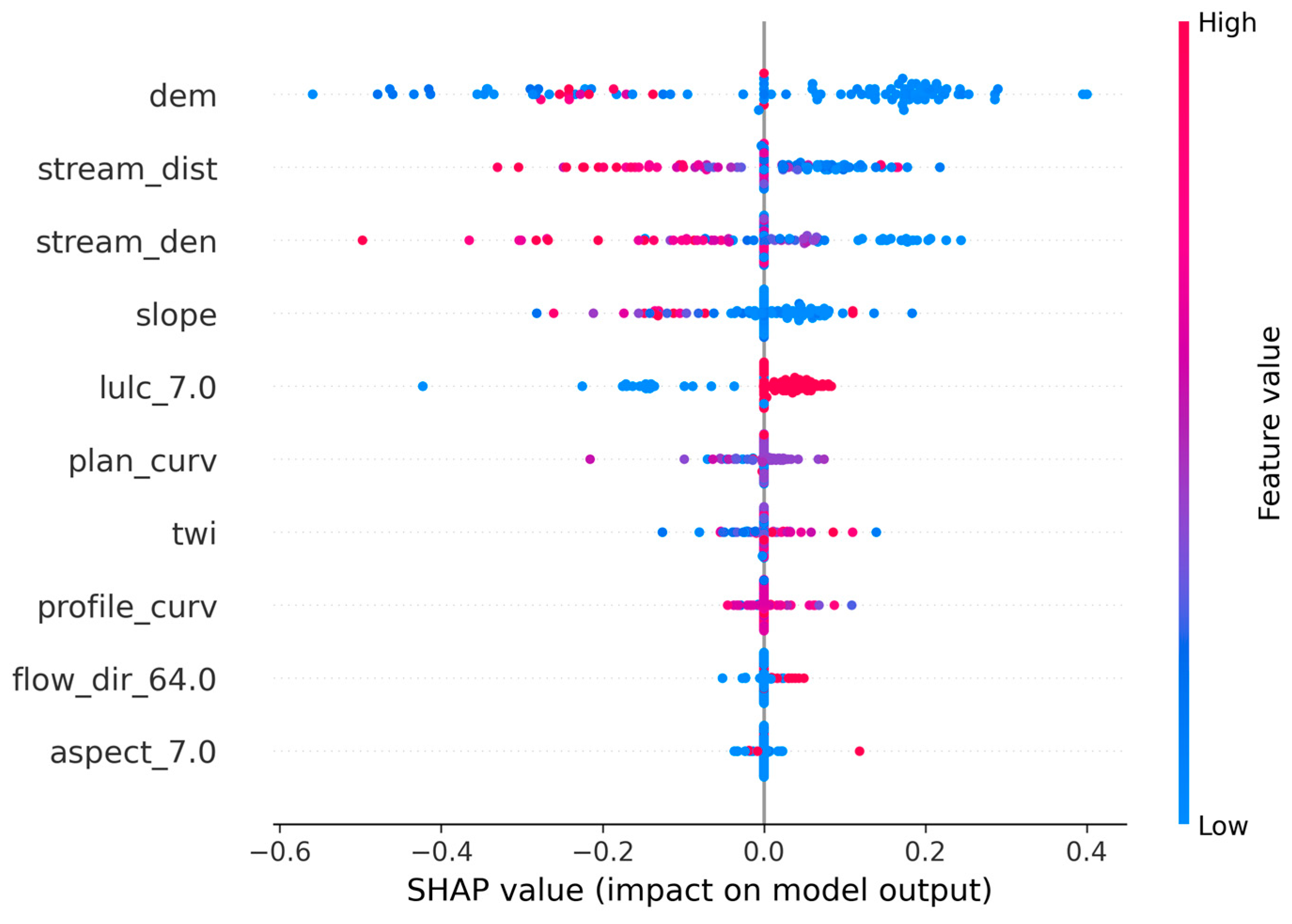
4.5.1. Summary Plot
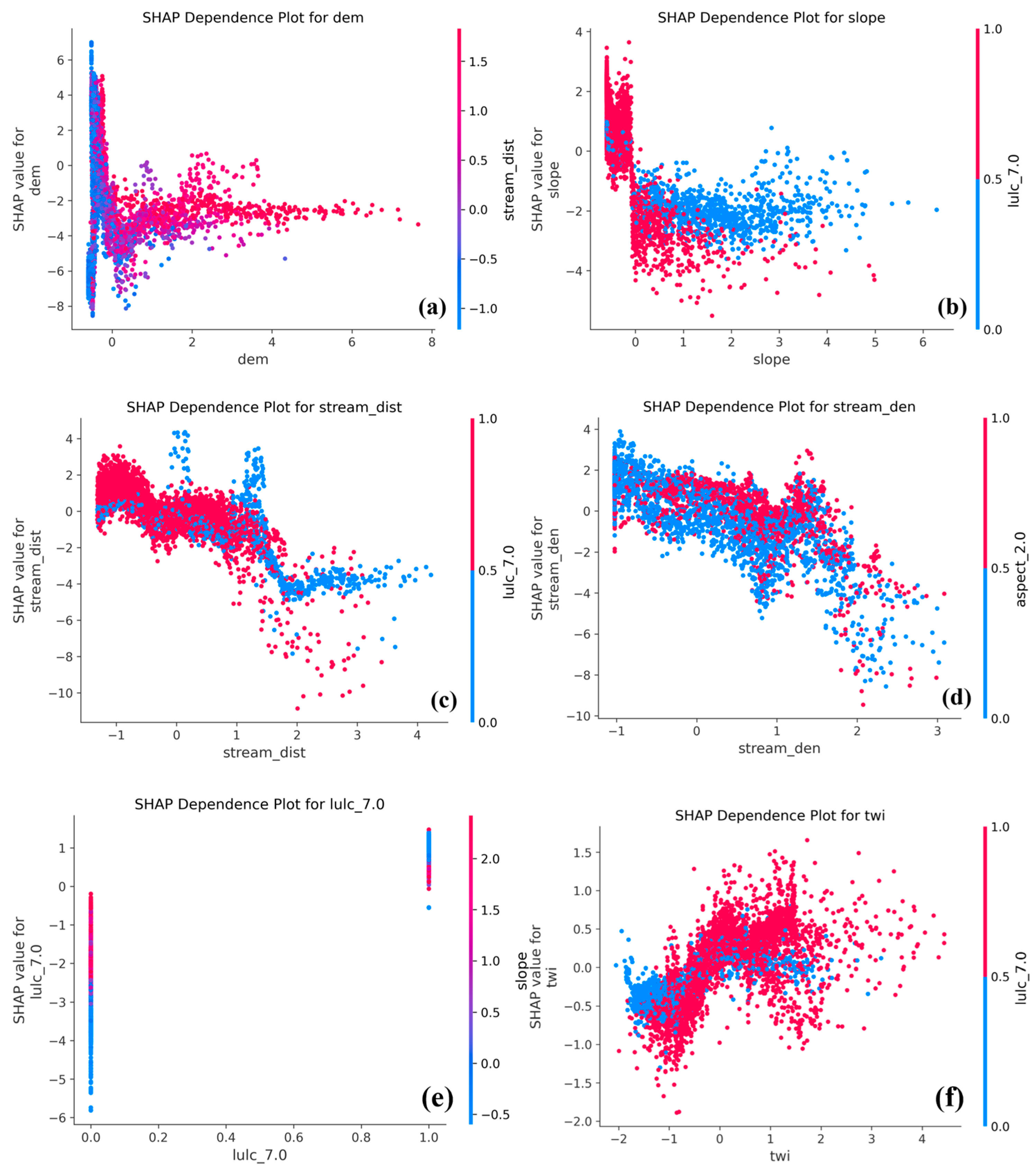
4.5.2. Dependence Plot
4.5.3. Force Plot
4.6. Rationale for Sample-Based SHAP Visualizations
5. Discussion
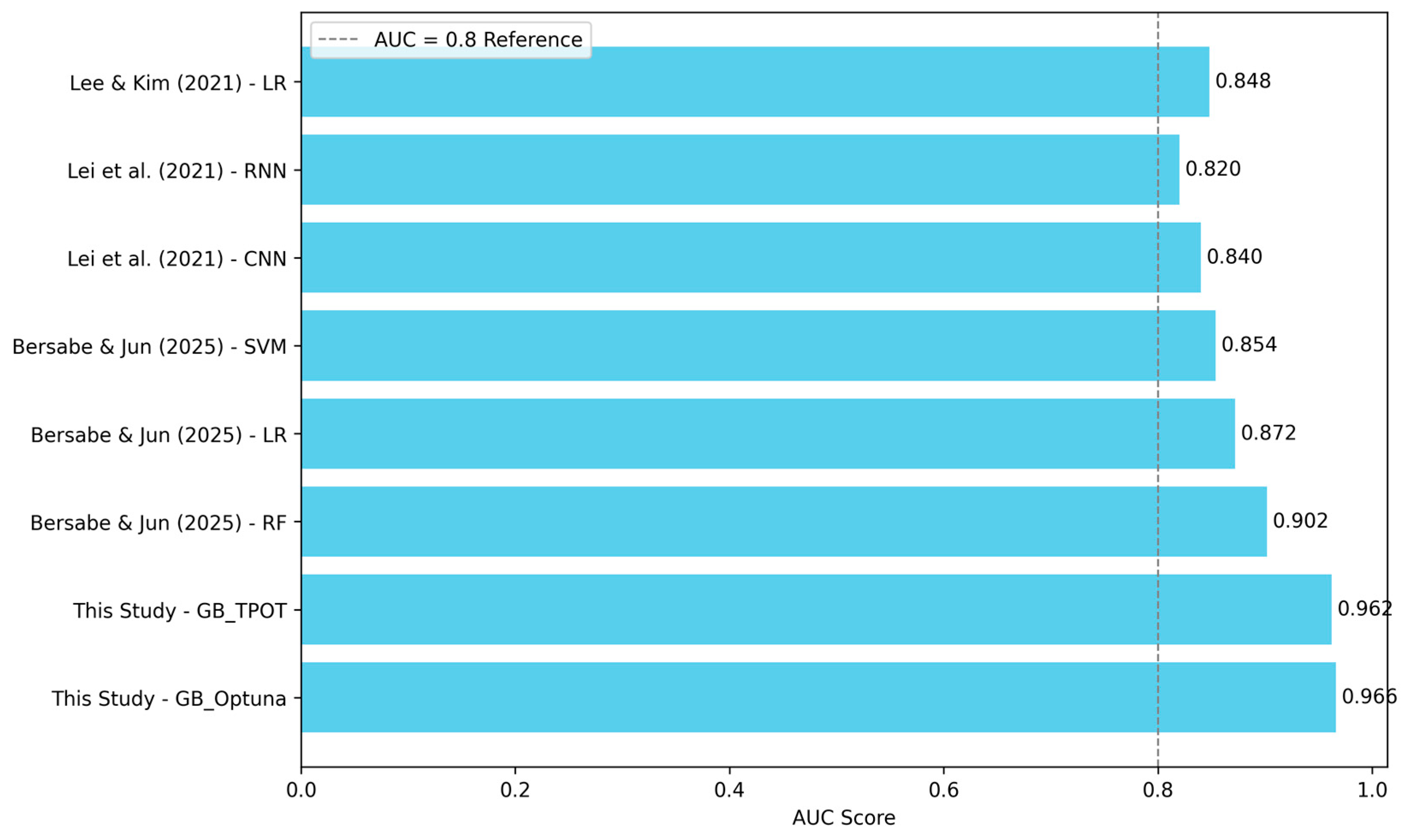
5.1. Comparison with Previous Studies
5.2. TPOT–Optuna Hybrid Optimization
5.3. Model Explainability via SHAP and Optuna for XAI
6. Conclusions
Author Contributions
Funding
Data Availability Statement
Acknowledgments
Conflicts of Interest
References
- Korea Research Institute for Human Settlements. KRIHS Issue Report No. 67; Korea Research Institute for Human Settlements: Sejong, Republic of Korea, 2022. [Google Scholar]
- Ha, G.; Jung, J. The Impact of Urbanization and Precipitation on Flood Damages. J. Korea Plan. Assoc. 2017, 52, 237–252. [Google Scholar] [CrossRef]
- Solomatine, D.P.; Ostfeld, A. Data-Driven Modelling: Some Past Experiences and New Approaches. J. Hydroinform. 2008, 10, 3–22. [Google Scholar] [CrossRef]
- Abedi, R.; Costache, R.; Shafizadeh-Moghadam, H.; Pham, Q.B. Flash-Flood Susceptibility Mapping Based on XGBoost, Random Forest and Boosted Regression Trees. Geocarto Int. 2022, 37, 5479–5496. [Google Scholar] [CrossRef]
- Chen, W.; Li, Y.; Xue, W.; Shahabi, H.; Li, S.; Hong, H.; Wang, X.; Bian, H.; Zhang, S.; Pradhan, B.; et al. Modeling Flood Susceptibility Using Data-Driven Approaches of Naïve Bayes Tree, Alternating Decision Tree, and Random Forest Methods. Sci. Total Environ. 2020, 701, 134979. [Google Scholar] [CrossRef]
- Pradhan, B.; Lee, S.R. Delineation of Landslide Hazard Areas on Penang Island, Malaysia, by using Frequency Ratio, Logistic Regression, and Artificial Neural Network Models. Environ. Earth Sci. 2010, 60, 1037–1054. [Google Scholar] [CrossRef]
- Aziz, K.; Rahman, A.; Fang, G.; Shrestha, S. Application of artificial neural networks in regional flood frequency analysis: A case study for Australia. Stoch. Environ. Res. Risk Assess. 2014, 28, 541–554. [Google Scholar] [CrossRef]
- Elsafi, S.H. Artificial neural networks (ANNs) for flood forecasting at Dongola Station in the River Nile, Sudan. Alex. Eng. J. 2014, 53, 655–662. [Google Scholar] [CrossRef]
- Sahana, M.; Rehman, S.; Sajjad, H.; Hong, H. Exploring Effectiveness of Frequency Ratio and Support Vector Machine Models in Storm Surge Flood Susceptibility Assessment: A Study of Sundarban Biosphere Reserve, India. Catena 2020, 189, 104450. [Google Scholar] [CrossRef]
- Tehrany, M.S.; Pradhan, B.; Jebur, M.N. Flood Susceptibility Mapping Using a Novel Ensemble Weights-of-Evidence and Support Vector Machine Models in GIS. J. Hydrol. 2014, 512, 332–343. [Google Scholar] [CrossRef]
- Tehrany, M.S.; Pradhan, B.; Mansor, S.; Ahmad, N. Flood Susceptibility Assessment Using GIS-Based Support Vector Machine Model with Different Kernel Types. Catena 2015, 125, 91–101. [Google Scholar] [CrossRef]
- Lyu, H.M.; Yin, Z.Y. Flood susceptibility prediction using tree-based machine learning models in the GBA. Sustain. Cities Soc. 2023, 97, 104744. [Google Scholar] [CrossRef]
- Ettinger, S.; Mounaud, L.; Magill, C.; Yao-Lafourcade, A.F.; Thouret, J.C.; Manville, V.; Negulescu, C.; Zuccaro, G.; De Gregorio, D.; Nardone, S. Building vulnerability to hydro-geomorphic hazards: Estimating damage probability from qualitative vulnerability assessment using logistic regression. J. Hydrol. 2016, 541, 563–581. [Google Scholar] [CrossRef]
- Bathrellos, G.; Karymbalis, E.; Skilodimou, H.; Gaki-Papanastassiou, K.; Baltas, E. Urban flood hazard assessment in the basin of Athens metropolitan city, Greece. Environ. Earth Sci. 2016, 75, 319. [Google Scholar] [CrossRef]
- Rahmati, O.; Pourghasemi, H.R.; Zeinivand, H. Flood susceptibility mapping using frequency ratio and weights-of-evidence models in the Golastan Province, Iran. Geocarto Int. 2016, 31, 42–70. [Google Scholar] [CrossRef]
- Bui, D.T.; Pradhan, B.; Nampak, H.; Bui, Q.T.; Tran, Q.A.; Nguyen, Q.P. Hybrid artificial intelligence approach based on neural fuzzy inference model and metaheuristic optimization for flood susceptibility modeling in a high-frequency tropical cyclone area using GIS. J. Hydrol. 2016, 540, 317–330. [Google Scholar] [CrossRef]
- Youssef, A.M.; Pradhan, B.; Sefry, S.A. Flash flood susceptibility assessment in Jeddah City (Kingdom of Saudi Arabia) using bivariate and multivariate statistical models. Environ. Earth Sci. 2016, 75, 12. [Google Scholar] [CrossRef]
- Amirebrahimi, S.; Rajabifard, A.; Mendis, P.; Ngo, T. A framework for a microscale flood damage assessment and visualization for a building using BIM–GIS integration. Int. J. Digit. Earth 2016, 9, 363–386. [Google Scholar] [CrossRef]
- Rahmati, O.; Zeinivand, H.; Besharat, M. Flood hazard zoning in Yasooj Region, Iran, using GIS and multi-criteria decision analysis. Geomat. Nat. Hazards Risk 2016, 7, 1000–1017. [Google Scholar] [CrossRef]
- Gu, H.; Gao, Y.; Fei, Y.; Sun, Y.; Tian, Y. Deep Learning and Hydrological Feature Constraint Strategies for Dam Detection: Global Application to Sentinel-2 Remote Sensing Imagery. Remote Sens. 2025, 17, 1194. [Google Scholar] [CrossRef]
- Mohsenifar, A.; Mohammadzadeh, A.; Jamali, S. Unsupervised Rural Flood Mapping from Bi-Temporal Sentinel-1 Images Using an Improved Wavelet-Fusion Flood-Change Index (IWFCI) and an Uncertainty-Sensitive Markov Random Field (USMRF) Model. Remote Sens. 2025, 17, 1024. [Google Scholar] [CrossRef]
- Askar, S.; Zeraat Peyma, S.; Yousef, M.M.; Prodanova, N.A.; Muda, I.; Elsahabi, M.; Hatamiafkoueieh, J. Flood Susceptibility Mapping Using Remote Sensing and Integration of Decision Table Classifier and Metaheuristic Algorithms. Water 2022, 14, 3062. [Google Scholar] [CrossRef]
- Rezaie, F.; Panahi, M.; Bateni, S.M.; Jun, C.; Neale, C.M.; Lee, S. Novel hybrid models by coupling support vector regression (SVR) with meta-heuristic algorithms (WOA and GWO) for flood susceptibility mapping. Nat. Hazards 2022, 114, 1247–1283. [Google Scholar] [CrossRef]
- Arora, A.; Arabameri, A.; Pandey, M.; Siddiqui, M.A.; Shukla, U.; Bui, D.T.; Mishra, V.N.; Bhardwaj, A. Optimization of state-of-the-art fuzzy-metaheuristic anfis-based machine learning models for flood susceptibility prediction mapping in the Middle Ganga Plain, India. Sci. Total Environ. 2021, 750, 141565. [Google Scholar] [CrossRef] [PubMed]
- Dodangeh, E.; Panahi, M.; Rezaie, F.; Lee, S.; Bui, D.T.; Lee, C.-W.; Pradhan, B. Novel hybrid intelligence models for flood-susceptibility prediction: Meta optimization of the gmdh and svr models with the genetic algorithm and harmony search. J. Hydrol. 2020, 590, 125423. [Google Scholar] [CrossRef]
- Bui, D.T.; Panahi, M.; Shahabi, H.; Singh, V.P.; Shirzadi, A.; Chapi, K.; Khosravi, K.; Chen, W.; Panahi, S.; Li, S. Novel hybrid evolutionary algorithms for spatial prediction of floods. Sci. Rep. 2018, 8, 15364. [Google Scholar] [CrossRef]
- Gao, Y.; Lu, H.; Zhang, Y.; Jin, H.; Wu, S.; Gao, Y.; Zhang, S. Evaluating Yangtze River Delta Urban Agglomeration flood risk using hybrid method of AutoML and AHP. Nat. Hazards Earth Syst. Sci. Discuss, 2024; in review. [Google Scholar] [CrossRef]
- He, F.; Liu, S.; Mo, X.; Wang, Z. Interpretable flash flood susceptibility mapping in Yarlung Tsangpo River Basin using H2O Auto-ML. Sci. Rep. 2025, 15, 1702. [Google Scholar] [CrossRef]
- Vincent, A.M.; Jidesh, P. An improved hyperparameter optimization framework for AutoML systems using evolutionary algorithms. Sci. Rep. 2023, 13, 4737. [Google Scholar] [CrossRef]
- Pradhan, B.; Lee, R.; Dikshit, A.; Kim, H. Spatial flood susceptibility mapping using an explainable artificial intelligence (XAI) model. Geosci. Front. 2023, 14, 6. [Google Scholar] [CrossRef]
- Zhang, Y.; Wei, Y.; Yao, R.; Sun, P.; Zhen, N.; Xia, X. Data Uncertainty of Flood Susceptibility Using Non-Flood Samples. Remote Sens. 2025, 17, 375. [Google Scholar] [CrossRef]
- Park, S.; Kim, J.; Kang, J. Exploring Optimal Deep Tunnel Sewer Systems to Enhance Urban Pluvial Flood Resilience in the Gangnam Region, South Korea. J. Environ. Manag. 2024, 357, 120762. [Google Scholar] [CrossRef]
- Ogden, F.L.; Raj Pradhan, N.; Downer, C.W.; Zahner, J.A. Relative importance of impervious area, drainage density, width function, and subsurface storm drainage on flood runoff from an urbanized catchment. Water Resour. Res. 2011, 47, 1–12. [Google Scholar] [CrossRef]
- Yang, H.; Yao, R.; Dong, L.; Sun, P.; Zhang, Q.; Wei, Y.; Sun, S.; Aghakouchak, A. Advancing flood susceptibility modeling using stacking ensemble machine learning: A multi-model approach. J. Geogr. Sci. 2024, 34, 1513–1536. [Google Scholar] [CrossRef]
- Yariyan, P.; Avand, M.; Abbaspour, R.A.; Torabi Haghighi, A.; Costache, R.; Ghorbanzadeh, O.; Janizadeh, S.; Blaschke, T. Flood susceptibility mapping using an improved analytic network process with statistical models. Geomat. Nat. Hazards Risk 2020, 11, 2282–2314. [Google Scholar] [CrossRef]
- Tehrany, M.S.; Jones, S.; Shabani, F. Identifying the essential flood conditioning factors for flood prone area mapping using machine learning techniques. Catena 2019, 175, 174–192. [Google Scholar] [CrossRef]
- Elshawi, M.; Sakr, S. Automated machine learning: State-of-the-art and open challenges. arXiv 2019, arXiv:1906.02287. [Google Scholar] [CrossRef]
- Fortin, F.-A.; Rainville, F.; Gardner, M.; Parizeau, M.; Gagne, C. DEAP: Evolutionary algorithms made easy. J. Mach. Learn. Res. 2012, 13, 2171–2175. [Google Scholar]
- Olson, R.S.; Moore, J.H. TPOT: A tree-based pipeline optimization tool for automating machine learning. JMLR Workshop Conf. Proc. 2016, 64, 66–74. [Google Scholar] [CrossRef]
- Almarzooq, H.; Bin Waheed, U. Automating hyperparameter optimization in geophysics with Optuna: A comparative study. Geophys. Prospect. 2024, 72, 1778–1788. [Google Scholar] [CrossRef]
- Li, Y.; Cao, Y.; Yang, J.; Wu, M.; Yang, A.; Li, J. Optuna-DFNN: An Optuna framework-driven deep fuzzy neural network for predicting sintering performance in big data. Alex. Eng. J. 2024, 97, 100–113. [Google Scholar] [CrossRef]
- Shapley, L.S. Stochastic games. Proc. Natl. Acad. Sci. USA 1953, 39, 1095–1100. [Google Scholar] [CrossRef]
- Aydin, H.E.; Iban, M.C. Predicting and analyzing flood susceptibility using boosting-based ensemble machine learning algorithms with SHapley Additive exPlanations. Nat. Hazards 2023, 116, 2957–2991. [Google Scholar] [CrossRef]
- Kim, Y.; Kim, Y. Explainable heat-related mortality with random forest and SHapley Additive exPlanations (SHAP) models. Sustain. Cities Soc. 2022, 79, 103677. [Google Scholar] [CrossRef]
- Tariq, A.; Yan, J.; Ghaffar, B.; Qin, S.; Mousa, B.G.; Sharifi, A.; Huq, M.E.; Aslam, M. Flash Flood Susceptibility Assessment and Zonation by Integrating Analytic Hierarchy Process and Frequency Ratio Model with Diverse Spatial Data. Water 2022, 14, 3069. [Google Scholar] [CrossRef]
- Ferri, C.; Hernández-Orallo, J.; Modroiu, R. An Experimental Comparison of Performance Measures for Classification. Pattern Recognit. Lett. 2009, 30, 27–38. [Google Scholar] [CrossRef]
- Tharwat, A. Classification Assessment Methods. Appl. Comput. Inform. 2018, 17, 168–192. [Google Scholar] [CrossRef]
- Lee, J.Y.; Kim, J.S. Detecting Areas Vulnerable to Flooding Using Hydrological-Topographic Factors and Logistic Regression. Appl. Sci. 2021, 11, 5652. [Google Scholar] [CrossRef]
- Lei, X.; Chen, W.; Panahi, M.; Falah, F.; Rahmati, O.; Uuemaa, E.; Kalantari, Z.; Ferreira, C.S.S.; Rezaie, F.; Tiefenbacher, J.P.; et al. Urban Flood Modeling Using Deep-Learning Approaches in Seoul, South Korea. J. Hydrol. 2021, 601, 126684. [Google Scholar] [CrossRef]
- Bersabe, J.T.; Jun, B.-W. The Machine Learning-Based Mapping of Urban Pluvial Flood Susceptibility in Seoul Integrating Flood Conditioning Factors and Drainage-Related Data. ISPRS Int. J. Geo Inf. 2025, 14, 57. [Google Scholar] [CrossRef]


| Category | Factors | Scale | Value Range | Source |
|---|---|---|---|---|
| Inundation inventory | Flood area | Polygon | Flooded/ non-flooded (binary) | Seoul Metropolitan Government (https://data.seoul.go.kr, accessed on 7 October 2024) |
| Topographical factors | Elevation, plan curvature, profile curvature, slope, TWI | 5 m (resolution) | Continuous variables | National Disaster Management Research Institute (www.ndmi.go.kr accessed on 7 October 2024) |
| Aspect, Flow direction | ‘aspect_2’, ‘aspect_3’, ‘aspect_4’, ‘aspect_5’, ‘aspect_6’, ‘aspect_7.0’, ‘aspect_8’, ‘aspect_9’, ‘aspect_10’ ‘flow_dir_1’, ‘flow_dir_2’, ‘flow_dir_4’, ‘flow_dir_8’, ‘flow_dir_16’, ‘flow_dir_32’, ‘flow_dir_64’, ‘flow_dir_128’ | |||
| Hydrological factors | Distance to stream, Stream density | Polylines | Continuous variables | National Geographic Information Institute (https://www.ngii.go.kr accessed on 7 October 2024) |
| Remote sensing factors | LULC | 10 m (resolution) | ‘lulc_1.0’, ‘lulc_2.0’, ‘lulc_5.0’, ‘lulc_7.0’, ‘lulc_8.0’, ‘lulc_11.0’ | Google Earth Engine, Sentinel-2 satellite (https://code.earthengine.google.com/ accessed on 7 October 2024) |
| Variable | VIF | TOL |
|---|---|---|
| Aspect | 1.271 | 0.787 |
| Elevation | 3.321 | 0.301 |
| Flow direction | 1.040 | 0.961 |
| LULC | 1.537 | 0.651 |
| Plan curvature | 1.305 | 0.767 |
| Profile curvature | 1.277 | 0.783 |
| Slope | 3.255 | 0.307 |
| Stream density | 2.612 | 0.383 |
| Distance to stream | 3.406 | 0.294 |
| TWI | 1.798 | 0.556 |
| Model | ROC AUC | Accuracy | Precision | Recall | F1-Score | MCC |
|---|---|---|---|---|---|---|
| TPOT_GB | 0.962 | 0.894 | 0.886 | 0.903 | 0.895 | 0.787 |
| TPOT_RF | 0.935 | 0.851 | 0.837 | 0.871 | 0.854 | 0.702 |
| TPOT_XGB | 0.922 | 0.837 | 0.815 | 0.873 | 0.843 | 0.676 |
| Optuna_GB | 0.966 | 0.896 | 0.891 | 0.903 | 0.897 | 0.792 |
| Optuna_RF | 0.957 | 0.887 | 0.872 | 0.906 | 0.889 | 0.774 |
| Optuna_XGB | 0.963 | 0.894 | 0.888 | 0.903 | 0.895 | 0.789 |
Disclaimer/Publisher’s Note: The statements, opinions and data contained in all publications are solely those of the individual author(s) and contributor(s) and not of MDPI and/or the editor(s). MDPI and/or the editor(s) disclaim responsibility for any injury to people or property resulting from any ideas, methods, instructions or products referred to in the content. |
© 2025 by the authors. Licensee MDPI, Basel, Switzerland. This article is an open access article distributed under the terms and conditions of the Creative Commons Attribution (CC BY) license (https://creativecommons.org/licenses/by/4.0/).
Share and Cite
Nam, K.; Lee, Y.; Lee, S.; Kim, S.; Zhang, S. Explainable Artificial Intelligence (XAI) for Flood Susceptibility Assessment in Seoul: Leveraging Evolutionary and Bayesian AutoML Optimization. Remote Sens. 2025, 17, 2244. https://doi.org/10.3390/rs17132244
Nam K, Lee Y, Lee S, Kim S, Zhang S. Explainable Artificial Intelligence (XAI) for Flood Susceptibility Assessment in Seoul: Leveraging Evolutionary and Bayesian AutoML Optimization. Remote Sensing. 2025; 17(13):2244. https://doi.org/10.3390/rs17132244
Chicago/Turabian StyleNam, Kounghoon, Youngkyu Lee, Sungsu Lee, Sungyoon Kim, and Shuai Zhang. 2025. "Explainable Artificial Intelligence (XAI) for Flood Susceptibility Assessment in Seoul: Leveraging Evolutionary and Bayesian AutoML Optimization" Remote Sensing 17, no. 13: 2244. https://doi.org/10.3390/rs17132244
APA StyleNam, K., Lee, Y., Lee, S., Kim, S., & Zhang, S. (2025). Explainable Artificial Intelligence (XAI) for Flood Susceptibility Assessment in Seoul: Leveraging Evolutionary and Bayesian AutoML Optimization. Remote Sensing, 17(13), 2244. https://doi.org/10.3390/rs17132244