


Synergizing Multi-Temporal Remote Sensing and Systemic Resilience for Rainstorm–Flood Risk Zoning in the Northern Qinling Foothills: A Geospatial Modeling Approach
 ,
,
Abstract
1. Introduction
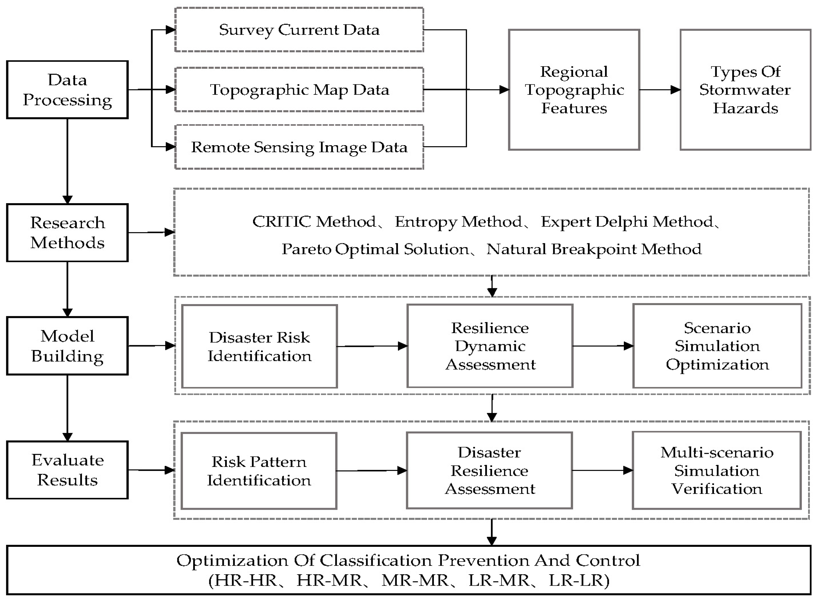
2. Materials and Methods
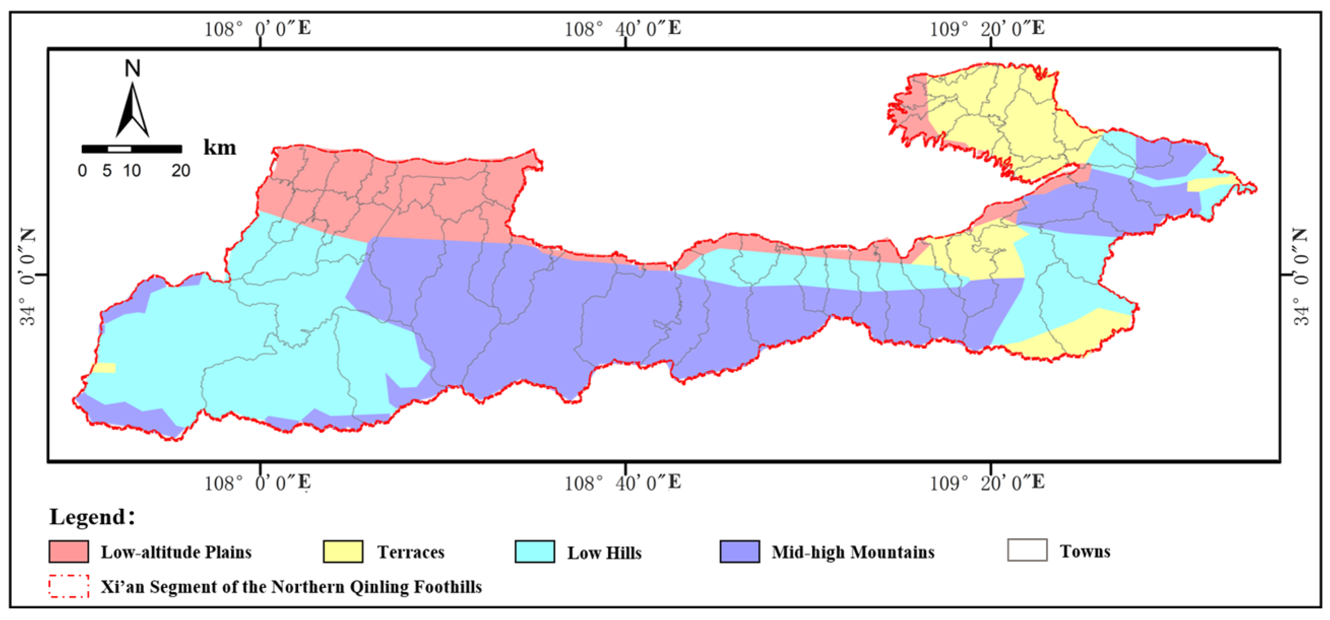
2.1. Geomorphological Settings
- (1)
- Geographical Pattern
- (2)
- Climatic Characteristics
- (3)
- Human Dimensions
2.2. Classification of Rainstorm–Flood Hazards
- (1)
- Flash Flood-Dominated Hazards
- (2)
- Urban Inundation-Dominated Hazards
- (3)
- Cascading Composite Hazards
2.3. Data Sources and Processing
2.4. Rainstorm–Flood Risk Identification Model
- (1)
- CRITIC Method
- (2)
- Entropy Weight Method
- (3)
- Composite Weighting
2.5. Spatial Morphological Resilience Index (SMRI) Model
- (1)
- Construction-Scale Adaptability Index ()
- (2)
- Land-Use Coordination Index ()
- (3)
- Functional Organization Elasticity Index ()
- (4)
- Comprehensive Spatial Resilience Model
2.6. Multi-Scenario Simulation and Validation Model
- (1)
- Land-Use Demand Projection (2035)
- (2)
- Spatial Allocation Rules (FLUS Module)
- (3)
- Calibration and Validation
3. Results
3.1. Risk Pattern Identification
- (1)
- Risk Assessment Outcomes
- (2)
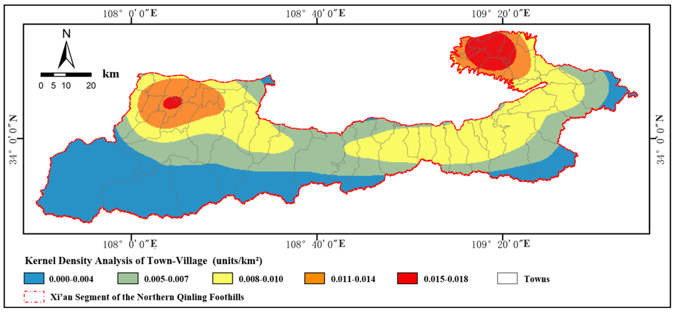
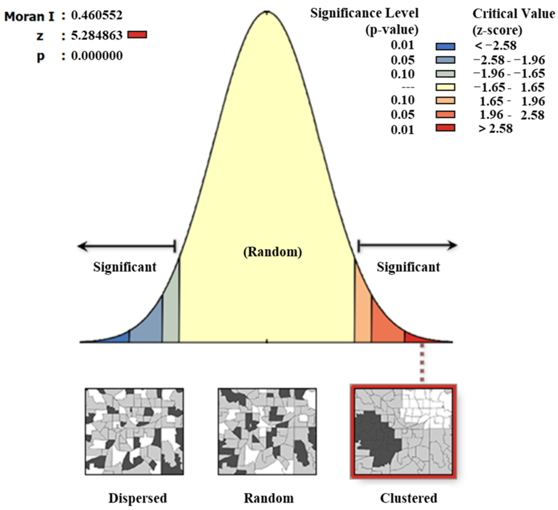
- Spatial Aggregation Characteristics
3.2. Disaster Adaptation Resilience Assessment
- (1)
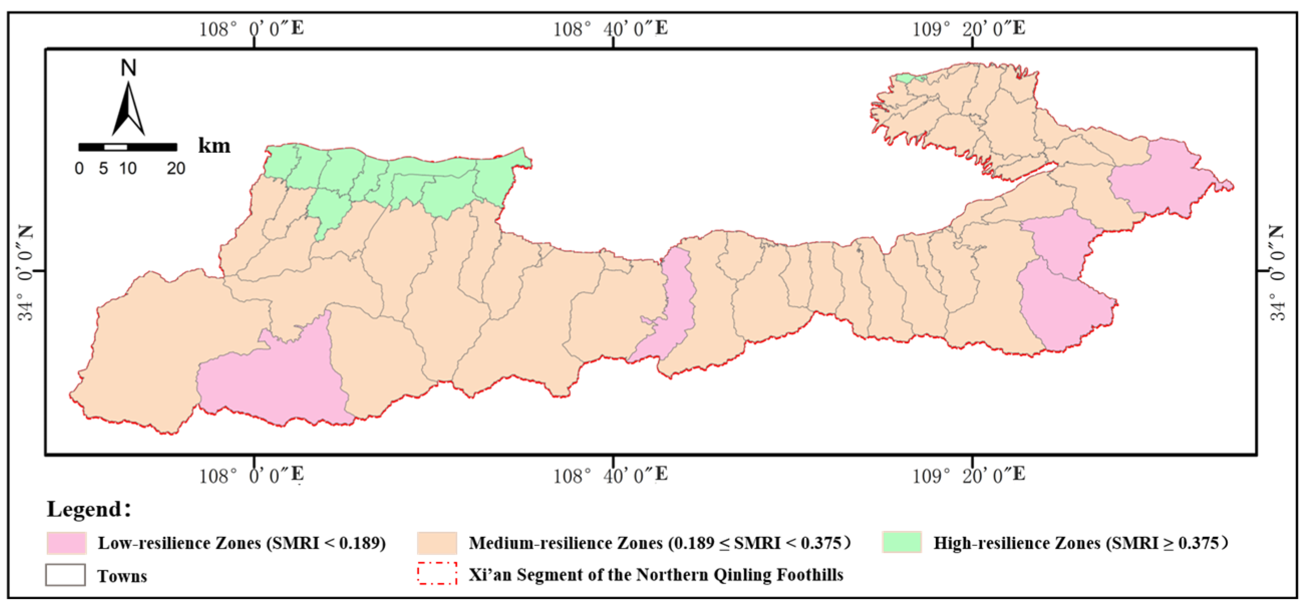
- Spatial Heterogeneity of Resilience Indices
- (2)
- Threshold Effects of Morphological Parameters
3.3. Multi-Scenario Simulation Validation
4. Discussion
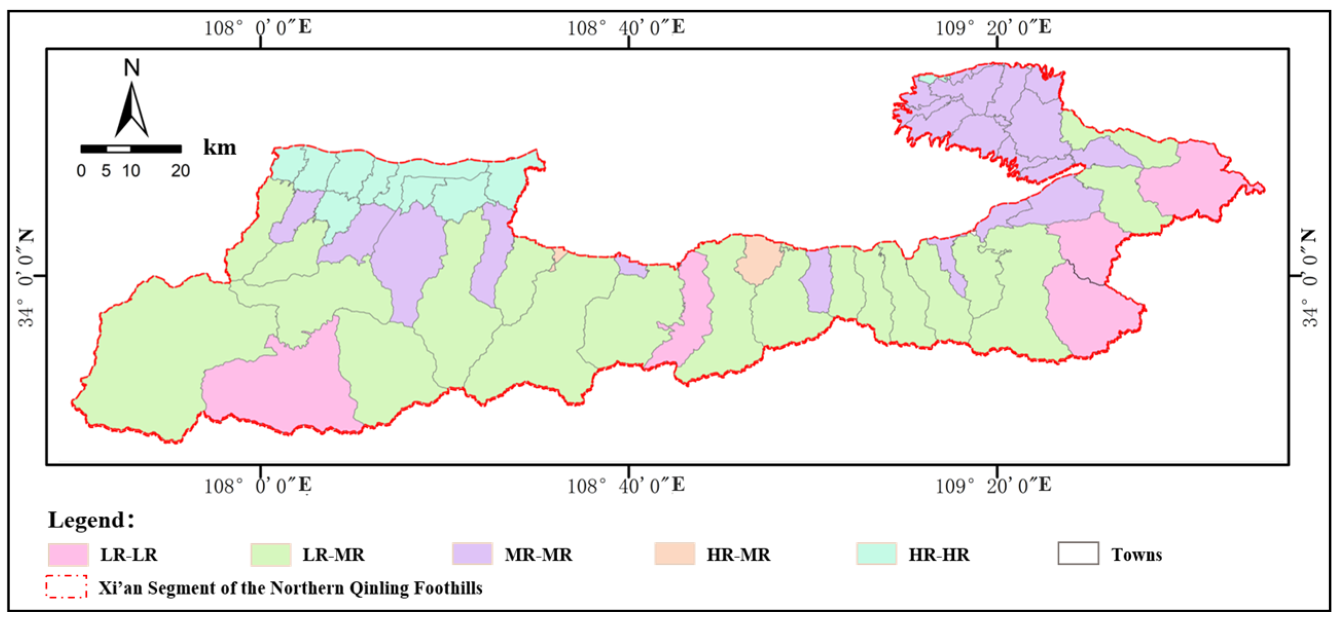
- (1)
- High-Risk–High-Resilience (HR-HR) Zones: Risk Prevention and Continuous Optimization
- (2)
- High-Risk–Medium-Resilience (HR-MR) Zones: Prioritized Mitigation and Resilience Enhancement
- (3)
- Medium-Risk–Medium-Resilience (MR-MR) Zones: Dynamic Equilibrium and Synergistic Optimization
- (4)
- Low-Risk–Medium-Resilience (LR-MR) Zones: Sustainable Development and Demonstration Leadership
- (5)
- Low-Risk–Low-Resilience (LR-LR) Zones: Resilience Building and Risk Prevention
5. Conclusions
- (1)
- Examining towns–villages as fundamental units of human settlement systems, their construction scale determines disaster exposure levels, land-use morphology influences stormwater runoff pathways, and functional organization constrains emergency response efficiency. These three factors constitute the core dimensions of the storm–flood resilience in the town–village spatial systems along the Xi’an segment of the northern Qinling foothills. The densely developed low-altitude alluvial plains further validate the systemic amplification of disasters through “human land system imbalance”;
- (2)
- Through the storm–flood hazard risk identification model, spatial morphology resilience index model (SMRI), and multi-scenario simulation validation framework, a “spatial morphology&disaster manifestation” coupling model was established. This corroborates the significant benefits of the “ecological priority pathway” for these towns–villages, as well as the hypothesis of a compounded disaster causation mechanism involving natural base constraints and spatial morphology mismatch. Compared to natural growth scenarios, high-risk zones decrease in area under ecological priority scenarios, while the SMRI improves the verification of the positive synergistic effect between ecological remediation and spatial morphology optimization;
- (3)
- Reconceptualizing storm–flood risks as outcomes of natural stressor effects and spatial morphology maladaptation, the optimal development mode for disaster loss reduction is identified as “medium-intensity development&moderately compact morphology&appropriate functional hybridity”;
- (4)
- For disaster-adaptive resilience enhancement, integrated strategies combining engineered intervention (e.g., green–gray infrastructure), monitoring early warning systems, and planning guidance mechanisms should be implemented through zonation-based multi-level optimization;
- (5)
- This study not only provides spatially differentiated optimization strategies for rainstorm–flood disaster prevention in the Xi’an segment of the northern Qinling foothills but also establishes a scalable framework applicable to disaster-resilient planning for mountainous towns globally. The proposed methodology bridges theoretical models and engineering practices, offering actionable insights for regions facing similar hydrogeomorphic challenges.
Author Contributions
Funding
Data Availability Statement
Conflicts of Interest
References
- Khan, A.; Smith, J.T.; Rahman, M.M. Assessing future climate impacts on hydroclimatic extremes in coastal regions: A case study of the Eastern Shore of Virginia. Sci. Total Environ. 2021, 944, 144371. [Google Scholar]
- Chen, L.; Wang, H.; Zhang, Y. Climate-driven increases in compound flooding risks for coastal megacities under SSP-RCP scenarios. Sci. Rep. 2021, 14, 77002. [Google Scholar]
- Zhou, B.T.; Qian, J. Interpretation of IPCC AR6 report: Changes in extreme weather and climate events. Adv. Clim. Chang. Res. 2021, 17, 713–718. [Google Scholar]
- Li, Y.; Zhao, S. Research on flood disaster losses and hazard risks in China during 2001–2020. Adv. Clim. Chang. Res. 2022, 18, 154–165. [Google Scholar]
- National Committee for Disaster Prevention; Mitigation and Relief Office; Ministry of Emergency Management. Basic Status of National Natural Disasters in 2023; Ministry of Emergency Management: Washington, DC, USA, 2024.
- Ministry of Emergency Management; Academy of Disaster Reduction and Emergency Management; Ministry of Education. 2022 Global Natural Disaster Assessment Report; Ministry of Education: Washington, DC, USA, 2023.
- Ministry of Emergency Management; Academy of Disaster Reduction and Emergency Management; Ministry of Education. 2021 Global Natural Disaster Assessment Report; Ministry of Education: Washington, DC, USA, 2022.
- Peng, J.; Shen, Y.; Jin, Z.; Liu, T.; Li, Y.; Zhuang, J.; Wang, H.; Yu, S.; Cheng, Y.; Ma, P.; et al. Key considerations in studying the eco-geological environmental system of the Qinling Mountains. J. Ecol. 2023, 43, 4345–4358. [Google Scholar]
- Guo, Z.; Shi, Y.; Liu, T.; Zhang, Y.; Yan, Y. Spatiotemporal patterns and drivers of NPP in the northern Qinling foothills from 2001–2020. Ecol. Environ. Sci. 2025, 34, 401–410. [Google Scholar]
- Yang, L.; Huo, A.; Zhao, Z.; Zhong, F.; Wang, X.; Chen, J. Analysis of future extreme precipitation and flood risks in the northern Qinling foothills based on CMIP6. Yellow River 2024, 46, 55–60+66. [Google Scholar]
- Cui, Y. Implications of international climate disaster governance for China’s ecological civilization construction. Int. Forum 2021, 23, 161. [Google Scholar]
- Zhang, Y.; Hu, J.; Li, Z.; Lu, Y.; Zhai, G. Research progress and prospects of urban rainstorm-flood risk governance. J. Hum. Settl. West China 2022, 37, 1–8. [Google Scholar]
- UNDRR. Midterm Review of the Sendai Framework for Disaster Risk Reduction 2015–2030; United Nations Office for Disaster Risk Reduction: Geneva, Switzerland, 2023. [Google Scholar]
- Heath, L.C.; Alam, G.M.M. Participatory modeling for coastal resilience planning in Bangladesh. Clim. Risk Manag. 2022, 36, 100430. [Google Scholar]
- Yang, Y.; Hu, D.; Guo, Y.; Yan, S. Lessons from the UK’s flood risk governance system for China. J. Arid Land Resour. Environ. 2023, 37, 126–135. [Google Scholar]
- Wang, J.; Hu, X.; Zhu, S.; Yang, C. Application and implications of Japan’s localized disaster prevention concepts: A case study of Shibuya Station, Tokyo. J. Disaster Prev. Mitig. Eng. 2024, 44, 1245–1256. [Google Scholar]
- Huang, L.; Zhang, Y.; Wan, X.; Wang, W.; Song, Y. Adaptive assessment of multi-hazard compound disaster systems: A case study of the Guangdong-Hong Kong-Macao Greater Bay Area. J. Hohai Univ. (Nat. Sci.) 2025, 1–11. Available online: http://kns.cnki.net/kcms/detail/32.1117.TV.20250205.1544.032.html (accessed on 21 April 2025).
- Yu, K. China’s model of climate-resilient territorial and urban spatial planning. City Plan. Rev. 2025, 49, 4–15. [Google Scholar]
- Yang, X.; Lu, S.; Xu, X.; Hang, J.; Yu, X. Urban flood vulnerability, resilience assessment, and disaster adaptation strategies: A case study of Guangzhou. Planners 2024, 40, 41–49. [Google Scholar]
- Zhai, G. Urban flood disaster resilience from planning perspectives under climate change: Key concepts, framework, and pathways. Urban Plan. Forum 2024, 1, 29–37. [Google Scholar]
- Song, Q.; Zhang, B.; Ma, D.; Wang, W. Review of quantitative community flood resilience assessment methods. J. Catastrophol. 2024, 39, 212–219. [Google Scholar]
- Li, C.; Zhu, P.; Li, K.; Zhou, L. Empirical study on urban morphology and climate resilience: Evidence from flood events in Macau. Urban Plan. Int. 2023, 38, 48–57. [Google Scholar]
- Wang, S.; Yun, Y.; Li, D. Measurement of urban flood risks and disaster planning responses. Mod. Urban Res. 2019, 11, 125–131. [Google Scholar]
- Li, T. Spatial study of urban vulnerability based on “exposure-sensitivity-adaptation”: A case study of Lanzhou. Econ. Geogr. 2017, 37, 86–95. [Google Scholar]
- Chen, Y.; Wang, Y.; Liu, Q.; Chen, X.; Zhou, Y. Land-use-based assessment model for mountain torrent disaster losses. J. Nat. Disasters 2021, 30, 52–59. [Google Scholar]
- Zhang, Q. Research on Social Resilience in Urban Flood Disaster Governance. Ph.D. Thesis, Lanzhou University, Lanzhou, China, 2021. [Google Scholar]
- Li, Z.; Fu, D.; Wang, J.; Min, K.; Zhang, J. Urban resilience evaluation model for waterlogging disasters and its application. J. Tsinghua Univ. (Sci. Technol.) 2022, 62, 266–276. [Google Scholar]
- Yin, M.; Liu, M.; Zhu, W.; Zhen, J. Urban waterlogging resilience assessment and influencing factors: A case study of Fuzhou. J. Saf. Sci. Technol. 2024, 20, 61–66. [Google Scholar]
- Huo, H.; Liu, Y.; Li, Y. Tracking hotspots in remote sensing research on flood disasters over recent 22 years: A bibliometric analysis based on citespace. J. Earth Environ. 2024, 15, 612–623. [Google Scholar]
- Shi, Q.; Peng, H.H.; Xia, H.N.; Tang, Z.; Chen, H. Progress in remote sensing monitoring and assessment of flood disasters: A citespace-based review. Yangtze River 2024, 55, 28–36+44. [Google Scholar]
- Zheng, Y.; Gao, L.H.; Li, R.; Jiang, W. Analysis and recommendations for remote sensing satellite services in emergency disaster reduction in China. Spacecr. Eng. 2024, 33, 148–154. [Google Scholar]
- Shen, W.H.; Zhong, Y.F.; Wang, J.J.; Zheng, Z.; Ma, A. Construction and application of flood disaster knowledge graph based on multi-modal data. Geomat. Inf. Sci. Wuhan Univ. 2023, 48, 2009–2018. [Google Scholar]
- Tang, W.G.; Xue, F.C.; Wan, J.Q.; Zhang, C.; Han, Y. Research and application of rainstorm flash flood simulation in mountainous small watersheds. Sci. Surv. Mapp. 2022, 47, 146–156. [Google Scholar]
- Huang, H.B.; Wang, X.W.; Liu, L. Urban rainstorm and waterlogging: A review on characteristics, mechanisms, data, and methods. Prog. Geogr. 2021, 40, 1048–1059. [Google Scholar] [CrossRef]
- Li, Y.; Wang, S.; Huang, H. Rural disaster vulnerability evaluation and influencing factors: A case study of Xun County, Henan Province. Sci. Geogr. Sin. 2024, 44, 1818–1825. [Google Scholar]
- Bai, H.; Shi, M.; Cao, Q.; Ning, Z. Spatial distribution and disaster resilience evaluation of traditional villages in earthquake-prone areas. J. Nat. Disasters 2024, 33, 30–41. [Google Scholar]
- Wen, H.; Qian, L.; Li, Z.; Huang, J. Resilience assessment of flood-landslide disasters in mountainous towns. J. Disaster Prev. Mitig. Eng. 2024, 44, 751–761. [Google Scholar]
- Dai, J.; Chen, W.; Shen, S. Optimization of rural settlements in plateau mountainous areas based on integrated disaster risk assessment: A case study of Ledu District, Haidong City, Qinghai. J. Catastrophol. 2021, 36, 119–125+132. [Google Scholar]
- Liu, D.; Peng, J.; Ye, W.; Ju, P.; Zhang, T.; Liu, K. Framework for livable villages in the Qinling Mountains. J. Xi’an Univ. Sci. Technol. 2023, 43, 743–751. [Google Scholar]
- Zhang, H.; Kong, F. Rural flood risk prevention strategies in China. Water Resour. Hydropower Eng. 2022, 53, 13–24. [Google Scholar]
- Liu, D.; Cui, Y.; Peng, J.; Cao, X.; Shen, Y.; Shao, L.; Li, D. Interaction between small towns and ecosystems in the northern Qinling foothills. Earth Sci. 2025, 1–14. Available online: http://kns.cnki.net/kcms/detail/42.1874.P.20250226.0926.002.html (accessed on 21 April 2025).
- Cheng, W.; Zhou, C.; Li, B.; Shen, Y. Research on the theoretical basis and zoning scheme of Chinese physiographic regionalization. Acta Geogr. Sin. 2019, 74, 839–856. [Google Scholar]
- Shi, P.; Wang, J.; Zhang, G.; Kong, F.; Wang, J. Regional differentiation and zoning of natural disasters in China. Geogr. Res. 2017, 36, 1401–1414. [Google Scholar]
- Xia, C.; Ma, D.; Guo, X.; Wang, Z.; Wang, W. Disaster resilience mechanisms and planning responses in territorial spatial planning under adaptive cycles. Urban Dev. Stud. 2024, 31, 44–52. [Google Scholar]
- Zeng, J.; Tian, J.; Wang, Q.; Sun, K. Climate resilience and flood adaptation theories in territorial planning: A case study of the Fujian Delta. Sci. Sin. Technol. 2023, 53, 1713–1727. [Google Scholar]
- Wang, W.; Zhu, J.; Fei, Z.; Ma, D.; Du, X. Framework and pathways for resilient territorial spatial planning and construction. Strateg. Study CAE 2023, 25, 209–218. [Google Scholar] [CrossRef]
- Dai, S.; Liu, T.; Gao, X.; Wang, J.; Xie, Z. Compilation and implementation mechanisms of territorial spatial disaster prevention planning. Urban Plan. Forum 2023, 48–53. [Google Scholar]
- Lv, Y.; Xiang, M.; Wang, J.; Wu, C. From disaster prevention to resilience-building: Pathways for territorial spatial governance. J. Nat. Resource. 2021, 36, 2281–2293. [Google Scholar]
- Li, Y.; Wang, Y.; Cai, X. From “disaster subjects” to “spatial ontology”: Theoretical foundations and resilient urban development in China. Shanghai Urban Plan. Rev. 2024, 5, 108–115. [Google Scholar]
- Chen, X.; Wang, P.; Fu, Z. Optimization of emergency shelter layouts in mountainous cities based on disaster risk assessment: A case study of Dongchuan District. J. Nat. Disasters 2020, 29, 162–174. [Google Scholar]

| Geomorphic Unit | Elevation (m) | Slope (%) | Towns/ Subdistricts (Count) | Proportion (%) | Villages (Count) | Proportion (%) | Regional Characteristics |
|---|---|---|---|---|---|---|---|
| Low-Altitude Plains | 391–899 | 0–8.9 | 20 | 35.1 | 193 | 30.0 | Urban–rural clusters dominated by anthropogenic activities |
| Low-Altitude Terraces | 900–1446 | 8.8–19.5 | 7 | 12.2 | 82 | 12.7 | Gentle-slope transitional zones (agriculture–ecosystem interface) |
| Low Hills | 1447–2000 | 19.5–28.9 | 12 | 21.0 | 102 | 15.8 | Hazard-prone areas under fold–fault tectonics |
| Mid-High Mountains | 2001–3732 | >29.0 | 18 | 31.6 | 265 | 41.5 | Intensely uplifted ecological barriers with active hazard sources |
| Total | – | – | 57 | 100 | 642 | 100 | – |
| No. | Data Category | Data Content | Sources and Accuracy |
|---|---|---|---|
| 1 | Geospatial Data | DEM (30 m), slope, aspect, hydrography, geology | NASA SRTM; 1:50,000 topographic maps |
| 2 | Meteorological–Hydrological | Hourly rainfall, flood extents, runoff coefficients | CMA; Hydrological Yearbooks |
| 3 | Land Use | Land cover classification (cropland, forest, etc.) | Institute of Geographic Sciences and Natural Resources Research, CAS (Kappa = 0.89) |
| 4 | Socioeconomic | Population density, infrastructure distribution | National Bureau of Statistics; POI data (10 m GPS accuracy) |
| 5 | Disaster Records | Hazard locations, losses, emergency responses | Ministry of Emergency Management |
| 6 | Planning Texts | Spatial plans, ecological redlines | Digitized municipal archives |
| Model | Criterion Layer | Indicator Layer | Specifications |
|---|---|---|---|
| Pressure | Hazard (Intensity) | Max 1 h rainfall (mm) | ANUSPLIN-interpolated grids (1 km2), extreme event probability distributions |
| Storm return period (years) | Gumbel distribution fitted to rainfall maxima (e.g., 50-year event, Tr = 50) | ||
| Runoff coefficient (%) | SCS-CN model calibrated with soil type and land use | ||
| State | Environmental (Sensitivity) | Slope (°) | 30 m DEM-derived; slope > 25° as high risk |
| NDVI | Landsat 8 OLI-derived (30 m resolution) | ||
| Soil infiltration rate (mm/h) | Measured via double-ring infiltrometer tests | ||
| Response | Socioeconomic (Vulnerability) | Population density (persons/km2) | Administrative unit-based residential counts |
| Building density (%) | Built-up area/total area per village | ||
| Facility accessibility (min) | 2SFCA-based 15 min emergency service coverage ratio |
| Weight Ratio (CRITIC: Entropy Value) | Fit of Historical Damage | Value Significance |
|---|---|---|
| 0.5:0.5 | 0.72 | <0.01 |
| 0.6:0.4 | 0.81 | <0.001 |
| 0.7:0.3 | 0.78 | <0.01 |
| Candidate Values (Λ) | Nash Efficiency Coefficient (NSE) | Policy Achievement Rate (%) | Composite Score |
|---|---|---|---|
| 0.50 | 0.78 | 89.2 | 0.824 |
| 0.55 | 0.81 | 92.7 | 0.865 |
| 0.60 | 0.77 | 85.4 | 0.792 |
| Scenario | Driving Factors | Key Parameterization |
|---|---|---|
| Business as Usual | Historical land-use trends | Annual built-up expansion: 2.8%; ecological land loss: 1.2%; sponge facilities: 15% |
| Ecological Priority | Carbon neutrality and hard conservation constraints | Built-up cap: 25%; ecological land ≥ 35%; green infrastructure investment ≥ 30% |
| Intensive Development | Accelerated urbanization and infrastructure upgrades | Built-up agglomeration index ≥ 0.7 (+50%); drainage standard: 30-year return period; detention capacity +2 × 10⁶ m3 |
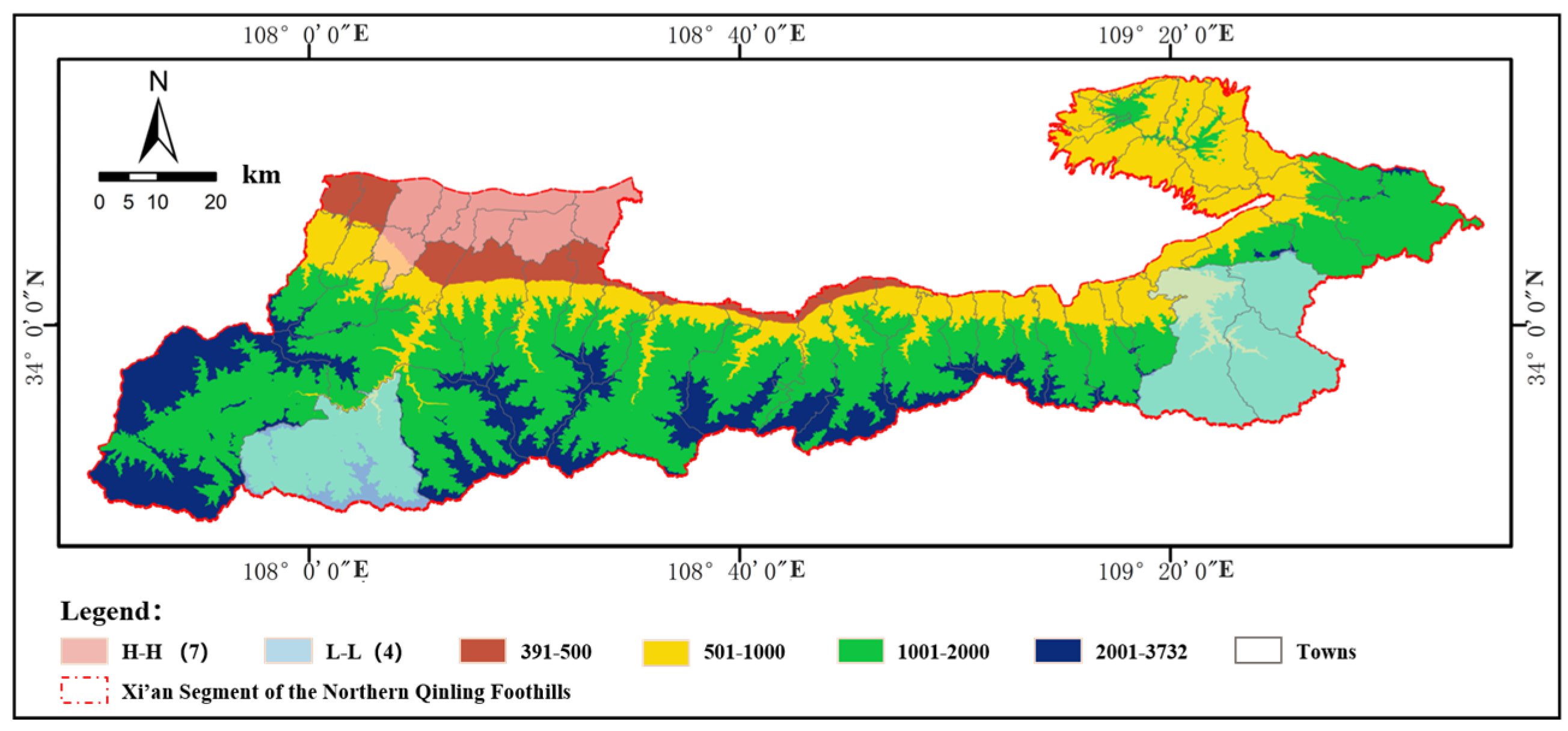
| Risk Tier | Area Share (%) | Risk Index Range | Geomorphic Characteristics |
|---|---|---|---|
| High-Risk Zone | 29.9 | 0.62–1.00 | Low-elevation plains, densely populated towns (population density > 200 persons/km2) |
| Medium-Risk Zone | 34.1 | 0.46–0.61 | Low terraces, farmland–town transitional areas |
| Low-Risk Zone | 36.0 | 0.00–0.45 | Low-mountain hills to alpine zones, ecological reserves, and unpopulated areas |
| Scenario | Risk Index (95% CI) | Built-Up Land Change | Ecological Land Change | High-Risk Zone Change | Dominant Drivers |
|---|---|---|---|---|---|
| Business as Usual | 0.68 ± 0.09 [0.59,0.77] | +38% | −7.2% | 32% | Population agglomeration, GDP growth rate |
| Ecological Priority | 0.47 ± 0.13 [0.34,0.60] | +18% | +5.6% | 18% | policy incentives, Ecological compensation mechanisms |
| Intensive Development | 0.72 ± 0.11 [0.61,0.83] | +55% | −8.9% | 45% | land finance, Industrial upgrading pressures |
Disclaimer/Publisher’s Note: The statements, opinions and data contained in all publications are solely those of the individual author(s) and contributor(s) and not of MDPI and/or the editor(s). MDPI and/or the editor(s) disclaim responsibility for any injury to people or property resulting from any ideas, methods, instructions or products referred to in the content. |
© 2025 by the authors. Licensee MDPI, Basel, Switzerland. This article is an open access article distributed under the terms and conditions of the Creative Commons Attribution (CC BY) license (https://creativecommons.org/licenses/by/4.0/).
Share and Cite
Liu, D.; Zhang, J.; Wang, X.; Peng, J.; Wang, R.; Huang, X.; Li, D.; Shao, L.; Hao, Z. Synergizing Multi-Temporal Remote Sensing and Systemic Resilience for Rainstorm–Flood Risk Zoning in the Northern Qinling Foothills: A Geospatial Modeling Approach. Remote Sens. 2025, 17, 2009. https://doi.org/10.3390/rs17122009
Liu D, Zhang J, Wang X, Peng J, Wang R, Huang X, Li D, Shao L, Hao Z. Synergizing Multi-Temporal Remote Sensing and Systemic Resilience for Rainstorm–Flood Risk Zoning in the Northern Qinling Foothills: A Geospatial Modeling Approach. Remote Sensing. 2025; 17(12):2009. https://doi.org/10.3390/rs17122009
Chicago/Turabian StyleLiu, Dong, Jiaqi Zhang, Xin Wang, Jianbing Peng, Rui Wang, Xiaoyan Huang, Denghui Li, Long Shao, and Zixuan Hao. 2025. "Synergizing Multi-Temporal Remote Sensing and Systemic Resilience for Rainstorm–Flood Risk Zoning in the Northern Qinling Foothills: A Geospatial Modeling Approach" Remote Sensing 17, no. 12: 2009. https://doi.org/10.3390/rs17122009
APA StyleLiu, D., Zhang, J., Wang, X., Peng, J., Wang, R., Huang, X., Li, D., Shao, L., & Hao, Z. (2025). Synergizing Multi-Temporal Remote Sensing and Systemic Resilience for Rainstorm–Flood Risk Zoning in the Northern Qinling Foothills: A Geospatial Modeling Approach. Remote Sensing, 17(12), 2009. https://doi.org/10.3390/rs17122009