Article

Quantifying Thermal Spatiotemporal Signatures and Identifying Hidden Mining-Induced Fissures with Various Burial Depths via UAV Infrared Thermometry

1
State Key Laboratory of Water Resource Protection and Utilization in Coal Mining, National Institute of Clean and Low Carbon Energy, Beijing 102211, China
2
Shendong Coal Group Co., Ltd., Ordos 017209, China
3
Beijing Key Laboratory for Precise Mining of Intergrown Energy and Resources, China University of Mining and Technology (Beijing), Beijing 100083, China
4
School of Energy & Mining Engineering, China University of Mining and Technology (Beijing), Beijing 100083, China
*
Author to whom correspondence should be addressed.
Remote Sens. 2025, 17(12), 1992; https://doi.org/10.3390/rs17121992
Submission received: 2 April 2025 / Revised: 30 May 2025 / Accepted: 6 June 2025 / Published: 9 June 2025

Abstract

Hidden mining-induced fissures connected to a goaf may induce spontaneous combustion of abandoned coal, threatening safe coal mining operation and ecological and environmental protection. To identify hidden mining-induced fissures rapidly, accurately and in a timely manner, a novel method involving infrared remote sensing via an unmanned aerial vehicle (UAV) was proposed. Hidden mining-induced fissures above working face No. 52605 of the Daliuta coal mine were continuously monitored using this method. Field experiments revealed that hidden mining-induced fissures could be effectively identified via infrared technology. The diurnal variation in the hidden mining-induced fissure temperature was cosinusoidal. The temperature of the hidden mining-induced fissures was highly correlated with burial depth, and the burial depths of the identified hidden mining-induced fissures differed at various times. The temperature differences among hidden mining-induced fissures, aeolian sands and vegetation varied with time and burial depth. The temperature difference variation between in situ hidden mining-induced fissures and aeolian sand matches that between hidden mining-induced fissures at a 20 cm burial depth and sand. In situ hidden mining-induced fissures could be identified from 1:00 to 5:00 a.m. and from 11:00 a.m. to 7:00 p.m. under the studied conditions.

1. Introduction

China’s western mining area constitutes a critical energy base for the country. The area hosts large reserves comprising shallow-buried coal seams with simple geological structures and excellent coal quality, but it is also characterised by a fragile ecological environment [1,2,3,4]. Secondary disasters due to high-intensity mining generally cause serious ecological and environmental problems. In particular, as a serious mining secondary geological disaster, ground mining-induced fissures can cause irreversible damage to the environment [5]. Ground mining-induced fissures connected to underground mined-out areas frequently cause spontaneous coal combustion, which seriously threatens safe mine production [6,7,8]. Therefore, it is important to identify ground mining-induced fissures in a timely, rapid and accurate manner. Moreover, the occurrence of fires in mined-out areas can be prevented by effective management.
Over the past few years, ground fissure detection and identification technologies have included mainly field surveys [2,9]; satellite positioning technology, such as global positioning system (GPS) or global navigation satellite system (GNSS) technology [10,11,12]; interferometric synthetic aperture radar (InSAR)/synthetic aperture radar (SAR) [13,14,15]; laser scanning technology [16,17,18]; and remote sensing technology [10,19,20,21]. Field surveys, which rely on manual inspections, struggle to identify fissures concealed by aeolian sand or sparse vegetation, while hazardous or inaccessible terrain further limits their applicability and escalates safety risks. GPS/GNSS technology, despite its precision in deformation monitoring, suffers from signal obstruction in densely vegetated or rugged areas and fails to capture shallow hidden fissures with minimal surface displacement due to its sparse spatial resolution. InSAR, although effective for large-scale subsidence mapping, is hampered by temporal decorrelation caused by vegetation growth or dynamic surface changes (e.g., shifting sand), masking subtle fissure-related deformations, whereas its reliance on satellite revisit cycles restricts real-time monitoring. In contrast, unmanned aerial vehicle (UAV)-based remote sensing technology provides the advantages of high resolution, notable flexibility, high efficiency, low operating cost and a large amount of data acquired at one time. At present, a UAV equipped with a visible light camera is mostly used to observe visible ground fissures. However, this method is easily affected by weather factors such as clouds and fog. In addition, the western area of China is mostly an arid and semiarid area with severe land desertification, and ground mining-induced fissures are easily covered by aeolian sand and vegetation to produce shallow surface hidden mining-induced fissures, which are difficult to identify. Collectively, these methods lack the resolution, accessibility, or environmental adaptability required to address hidden mining-induced fissures in ecologically fragile mining regions.
The wavelength of infrared light is greater than that of visible light, its penetration is greater than that of visible light, and infrared light is less affected by the external environment. Infrared cameras are sensitive to areas with significant infrared thermal properties and provide satisfactory target detection capabilities [22]. Objects with temperatures higher than 0 K can be captured by infrared cameras. Infrared thermal imaging technology has been widely used by scholars for fissure-monitoring purposes [23,24,25]. Notably, Y. Zhao et al. (2021) [26] used infrared remote sensing via a UAV to identify ground mining-induced fissures, and two types of mining-induced ground fissures could be effectively identified between 3:00 a.m. and 5:00 a.m. In addition, other scholars have studied the detection of hidden underground spaces and objects by UAVs equipped with thermal infrared cameras. For example, Antoine et al. (2020) [27] conducted an all-day UAV infrared surface temperature detection study of underground cavities to examine the evolution of their surface temperatures and analysed the factors responsible for notable zonal cooling. Koganti et al. (2021) [28] employed visible, near-infrared and thermal infrared images obtained by unmanned aircraft systems (UASs) to determine drainage pipe locations at a farm field test site in central Ohio (U.S.A.) and reported that thermal infrared imagery from UAS surveys was better suited for detecting drain line locations under dry surface conditions. Lee et al. (2016) [29] adopted a drone combined with a thermal far-infrared (FIR) camera to detect potential sinkholes within a large area via computer vision and pattern classification techniques. Notably, the continuous heat conduction of shallow ground mining-induced fissures inevitably leads to surface temperature anomalies, providing the possibility of identifying hidden mining-induced fissures via thermal infrared technology. Y. Zhao et al. (2022) [30] used an unmanned aerial vehicle (UAV) with an infrared camera and ground-penetrating radar (GPR) to detect hidden ground fissures and reported that the temperature in the area where the hidden ground fissure was located was higher than the surrounding temperature. UAV infrared thermography offers a transformative solution to the limitations of conventional methods by leveraging its unique ability to detect subsurface thermal anomalies caused by hidden mining-induced fissures. Moreover, it can rapidly acquire large-scale surface temperature data regardless of terrain constraints. This contrasts with point-based GPS/GNSS or labour-intensive field surveys. Compared with satellite-based InSAR or ground-based laser scanning, UAV systems reduce operational costs.
Shallow hidden mining-induced fissures with ventilation effects typically function as air leakage channels in mining areas, which poses significant hidden safety risks. Moreover, few studies have reported the use of UAV infrared technology for detecting the temperatures of hidden fissures at different burial depths on the surface in mining subsidence areas. In this work, to investigate the spatiotemporal variation in the temperature of and time window for monitoring hidden mining-induced fissures at different burial depths using infrared thermography, a UAV equipped with a thermal imager was deployed above the No. 52605 working face of the coal mine in Shendong for 24 h.

2. Materials and Methods

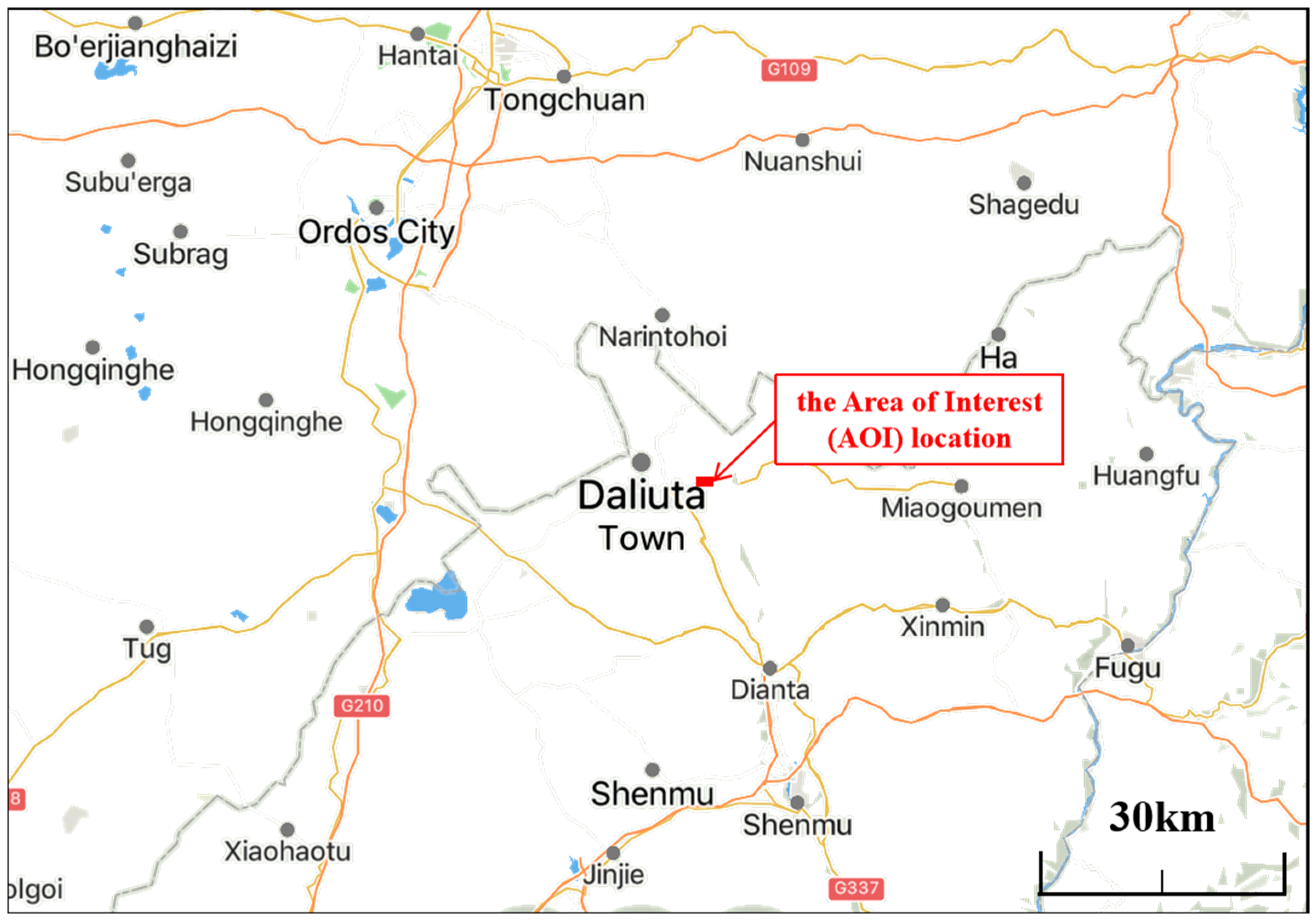
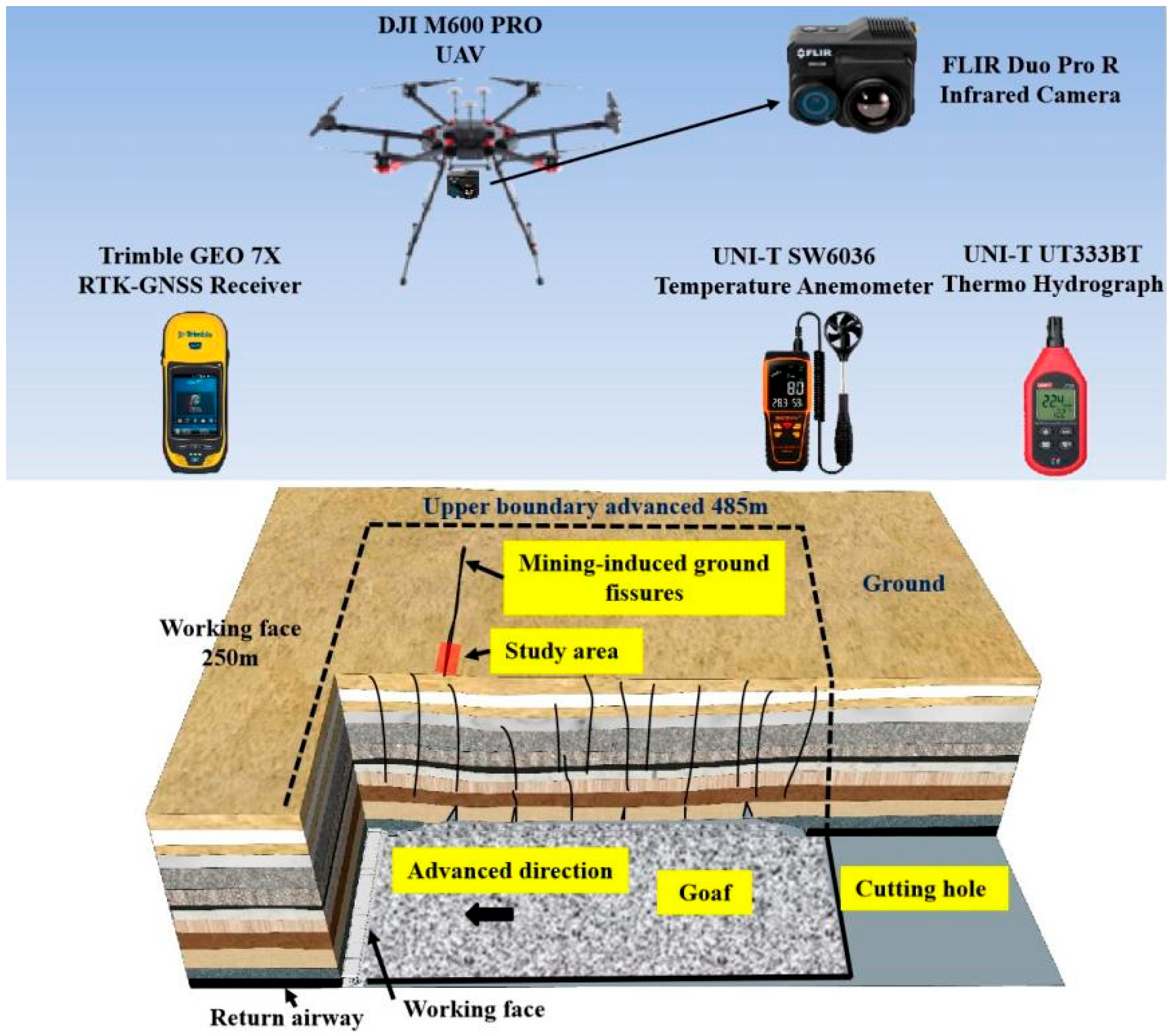
2.1. Engineering Investigation Background

This study was conducted at the No. 52605 working face of the Daliuta coal mine, which is an extralarge, modern, high-yield mine of the Shendong Coal Company, with an annual output of more than 20 million tons. The Daliuta mine field is 10.5~13.9 km long from east to west and 9.1~10.5 km wide from north to south and covers an area of 126.8 km2. The mine field is located approximately 52.5 km northwest of Shenmu County, Shaanxi Province, China, and on the northern side of the Loess Plateau in northern Shaanxi, which is the southeastern edge of the Mu Us Desert, as shown in Figure 1. The terrain is high in the north, low in the south, high in the middle, and low in the east and west. The area encompasses various aeolian sand accumulation landforms, with staggered sand dunes, sand ridges and sand flats, where vegetation is scarce. The No. 52605 working face of the Daliuta mine adopts the methods of strike longwall mining at full height and full caving mining. The working face is arranged along the inclination, with a slope length of 305.4 m, a mining height of 4.3 m, and an advance length of 4299 m. The ground elevation of the No. 52605 working face ranges from 1160 to 1280 m, the seam floor elevation ranges from 1037.09 to 1075.7 m, and the depth of burial ranges from 122.91 to 204.3 m. The cumulative footage of the working face reached 250 m on the day of observation.

2.2. Equipment Used for Identifying Hidden Mining-Induced Fissures

As shown in Figure 2, a DJI UAV (M600 Pro, Dajiang, China) equipped with an FLIR Duo Pro R thermal imager (Duo Pro R 336, FLIR, Wilsonville, OR, America) and a visible light camera (Duo Pro R 640, FLIR, Wilsonville, OR, America) was used to observe hidden mining-induced fissures at different burial depths. The main technical parameters and specifications of the infrared imager and UAV are provided in Table 1. A Duo Pro R 336 high-definition infrared camera was used to collect the thermal radiation information of the targets, namely, aeolian sand, vegetation and hidden mining-induced fissures, and the data were converted into visual images. These images were subsequently used to identify hidden mining-induced fissures. A Duo Pro R 640 visible light camera was adopted to capture high-resolution images, which were used as a reference for the infrared images. In addition, an anemometer (SW6036), a temperature and humidity meter (UT333), and a soil tester were used to measure the temperature, humidity and wind speed, respectively. The measuring equipment is shown in Figure 2.

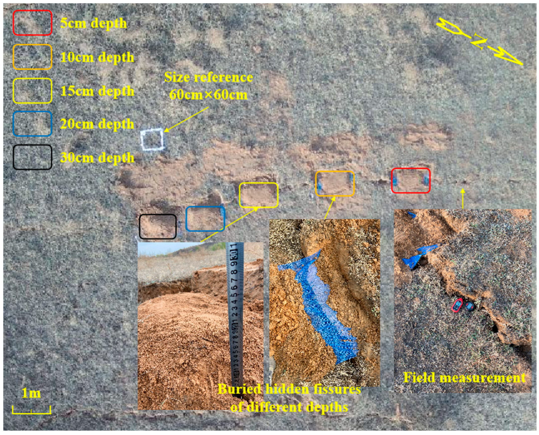
2.3. Infrared Monitoring Experiment of Hidden Mining-Induced Fissures at Different Burial Depths

To explore the temperature characteristics and identify hidden mining-induced fissures at different burial depths via infrared imaging, a mining-induced fissure in the No. 52605 working face of the Daliuta mine was covered with sand, and the burial depths were 5, 10, 15, 20 and 30 cm, as shown in Figure 3. To strictly control the burial depth, gauze was placed over the mining-induced fissure to prevent soil from infiltrating the fissure, which could indirectly affect the burial depth. A UAV equipped with an FLIR Duo Pro R336 thermal imager was deployed to collect infrared images of the hidden mining-induced fissures at different burial depths and at different times (7:00 p.m., 9:00 p.m., 11:00 p.m., 1:00 a.m., 3:00 a.m., 5:00 a.m., 7:00 a.m., 9:00 a.m., 11:00 a.m., 1:00 p.m., 3:00 p.m., and 5:00 p.m., at 2 h intervals). During image acquisition, the flying altitudes of the UAV were 15, 20, 25 and 30 m, and the test was performed in spring. The temperature and humidity of the mining-induced fissures were manually measured 10 min before each aerial photograph was taken to assess the accuracy of the infrared images, and the atmospheric temperature, wind speed and atmospheric humidity were simultaneously measured.

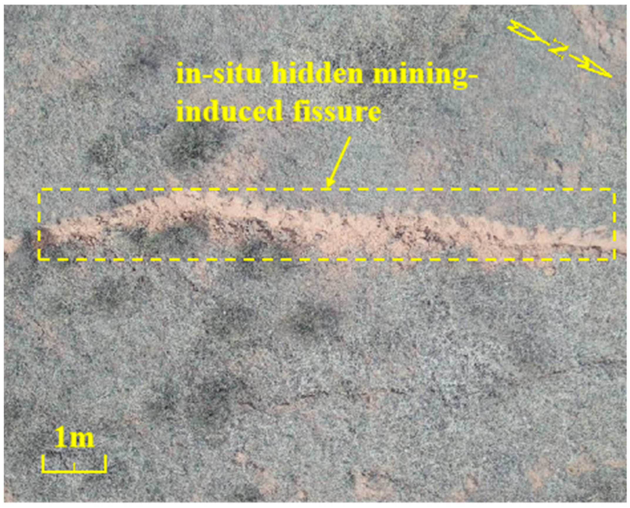
2.4. Identification Experiment of the In Situ Hidden Mining-Induced Fissure

As shown in Figure 4, the mining-induced fissure covered by sand in the No. 52605 working face of the Daliuta mine could be detected. To identify in situ hidden mining-induced fissures, a UAV equipped with an FLIR Duo Pro R336 thermal imager was adopted to collect infrared images at different times (7:00 p.m., 9:00 p.m., 11:00 p.m., 1:00 a.m., 3:00 a.m., 5:00 a.m., 7:00 a.m., 9:00 a.m., 11:00 a.m., 1:00 p.m., 3:00 p.m., and 5:00 p.m., at 2 h intervals), and the flight altitude was 20 m.

2.5. Temperature Extracted from the Infrared Images

As shown in Figure 3 and Figure 4, there were four primary types of ground features: aeolian sand, vegetation and ground and hidden mining-induced fissures. The temperature of aeolian sand is directly controlled by environmental conditions, such as the atmospheric temperature and solar radiation intensity. However, the temperature of mining-induced fissures is also closely related to the ventilation conditions in the mined-out area and deep ground temperature. The life activities of vegetation, such as transpiration and respiration, ensure relative temperature stability. The temperature of hidden mining-induced fissures is affected by heat conduction, solar radiation intensity and atmospheric temperature. Thus, there are differences in the temperatures among these four ground features under the same external environmental conditions. The intensities of infrared radiation from aeolian sand, vegetation, ground mining-induced fissures and hidden mining-induced fissures differ at different temperatures and exhibit varying colours and brightness levels. It is easy to distinguish the types of ground features according to the colours and shapes within regions in the infrared images. Each pixel in the infrared image contains information on the radiative temperature of the actual measured object.
FLIR Tools 5.13 software was used to extract the radiative temperatures of the above four ground features accurately. To reduce errors, the temperature was extracted in regions with aeolian sand, vegetation, ground mining-induced fissures and hidden mining-induced fissures. On the basis of the obtained sample data, the temperature differences between the four types of ground features were statistically estimated to analyse the temperature distribution patterns.
To accurately extract the radiant temperatures of the four ground features mentioned above, FLIR Tools software was used to analyse the infrared images and extract the temperatures of the objects in them. This software accompanies the Duo Pro R 336 infrared camera, which is specifically designed to extract temperature information from infrared images. The infrared images acquired by Duo Pro R336 are imported into FLIR Tools software. The four features mentioned above are then selected using rectangular boxes, and the software automatically extracts the temperature information from within the boxes and provides an average temperature. To reduce errors caused by human operation of the rectangular box when a large range of objects is selected, the temperature of each object is extracted by operating the rectangular box to select the object several times, and the average value is then calculated. On the basis of the large sample size, the temperature difference between the four landforms was statistically estimated to analyse the temperature distribution pattern. To verify the accuracy of the object temperatures in the infrared images, the temperatures of the ground mining-induced fissures were measured using a UT333 monitor during the experiment. The accuracy of the temperature information in the infrared images was then analysed by comparing it with the temperatures of the fissures at the same locations in the images acquired at the same time points.

3. Results and Discussion

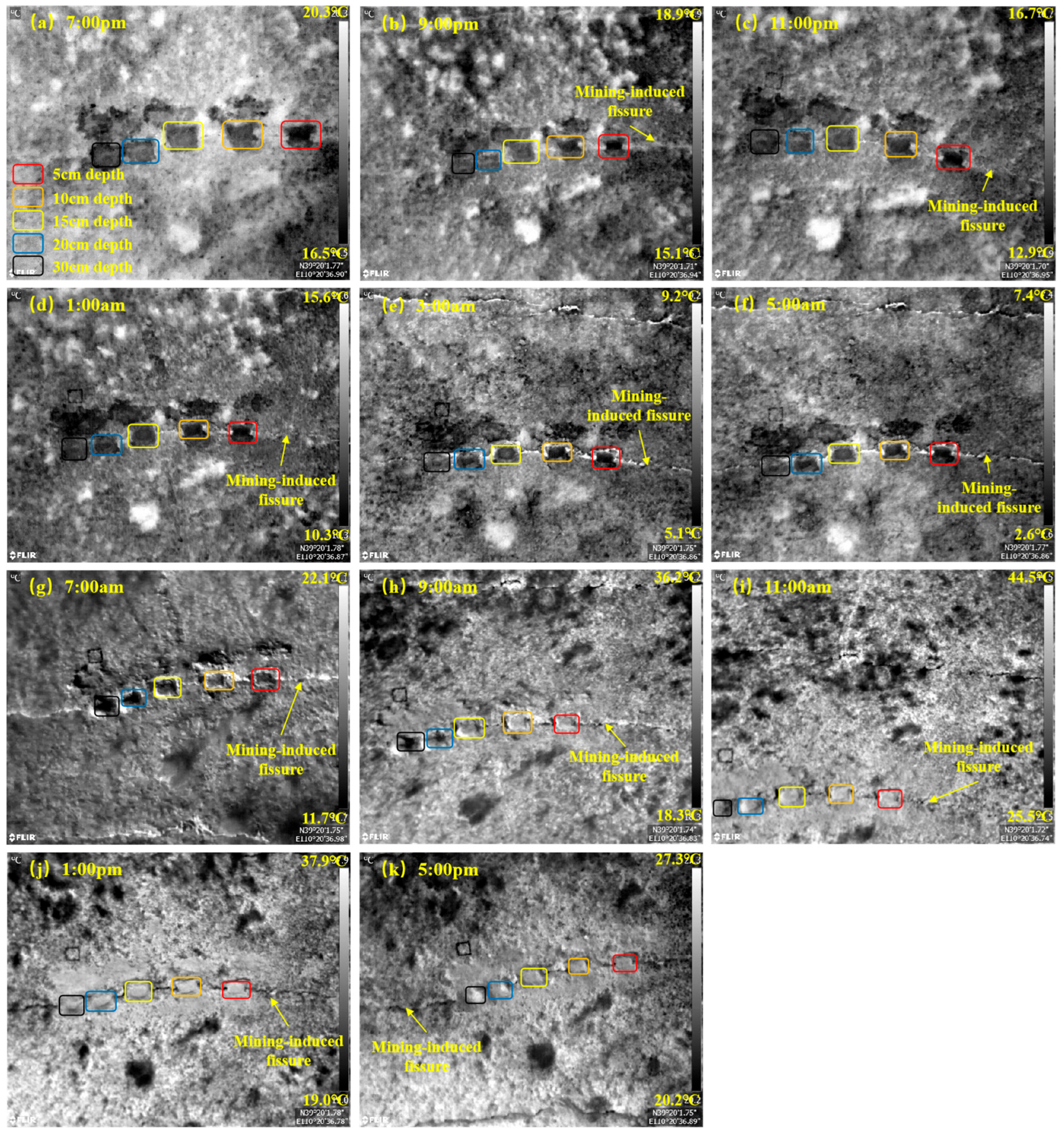
3.1. Infrared Images of the Test Area at Different Times

FLIR Tools software was used to select 11 infrared images with approximately the same resolution and obtained along the same direction from the 11 groups of infrared images of the experimental area at different times. The selected infrared images with a flight height of 25 m are shown in Figure 5. Figure 5a–k shows infrared images obtained at 7:00 p.m., 9:00 p.m., 11:00 p.m., 1:00 a.m., 3:00 a.m., 5:00 a.m., 7:00 a.m., 9:00 a.m., 11:00 a.m., 1:00 p.m., and 5:00 p.m. (due to a problem with the format of the image recorded at 3:00 p.m., the temperature could not be extracted; so, the infrared image obtained at 3:00 p.m. is not shown). As shown in Figure 5, ground mining-induced fissures and hidden mining-induced fissures at burial depths of 5, 10, 15, 20 and 30 cm could be detected.
In the infrared images, the objects are bright white, indicating a higher temperature of these objects, whereas dark colours indicate a lower temperature. At 7:00 p.m., the colour of the ground fissure is similar to that of the surrounding aeolian sand, making it difficult to identify. However, the colour of the aeolian sand overburden layer of the hidden fissure at the different burial depths is darker, and the temperature is lower than that of the surrounding aeolian sand, which is easy to distinguish from the surrounding environment in Figure 5a. As shown in Figure 5b–f, from 9:00 p.m. to 5:00 a.m., the ground fissures and vegetation are bright white. Over time, the former becomes brighter, whereas the colour of aeolian sand becomes darker, indicating easy identification during this period. The hidden objects at varying depths also exhibit darker colours, which vary with burial depth. Therefore, they can be distinguished from the surrounding environment. Figure 5g shows that the colour of the ground fissures is slightly darker than that of the surrounding aeolian sand, whereas the colour of the ground fissures at some locations is similar to that of aeolian sand; so, they cannot be easily identified at 7:00 a.m. Compared with the position of the ground fissure in Figure 3, the bright line at the position in Figure 5g corresponds to the ascending side of the dislocation. The topsoil on this side is exposed, and under the influence of the slanting sun, it presents a bright colour due to rapid warming. However, the hidden fissures at the different burial depths are darker in colour and lower in temperature than the surrounding aeolian sand, which can be easily distinguished from the surrounding environment. From 9:00 a.m. to 5:00 p.m., the ground fissures and vegetation are dark in colour, whereas the aeolian sand is bright white, as shown in Figure 5h–k. The colour of the hidden fissures varies greatly with burial depth, whereas the colour of the hidden fissures at some burial depths is similar to that of the surrounding aeolian sand. Therefore, identification is difficult, especially at noon and in the afternoon.
In summary, the ground fissures in the infrared images are bright white and prominent. They are complete, clear and easy to identify from 3:00 to 5:00 a.m. Similar results have been reported by Y. Zhao et al. (2021) [26]. At night, the colours of the hidden fissures at different burial depths obviously differ from those of the surrounding aeolian sand. Moreover, the colours of the hidden fissures differ slightly at different burial depths. Overall, the hidden fissures at different burial depths can be easily identified at night. During the day (except at 7:00 a.m.), the colours are similar to those of aeolian sand, which leads to difficulty in identifying these fissures.

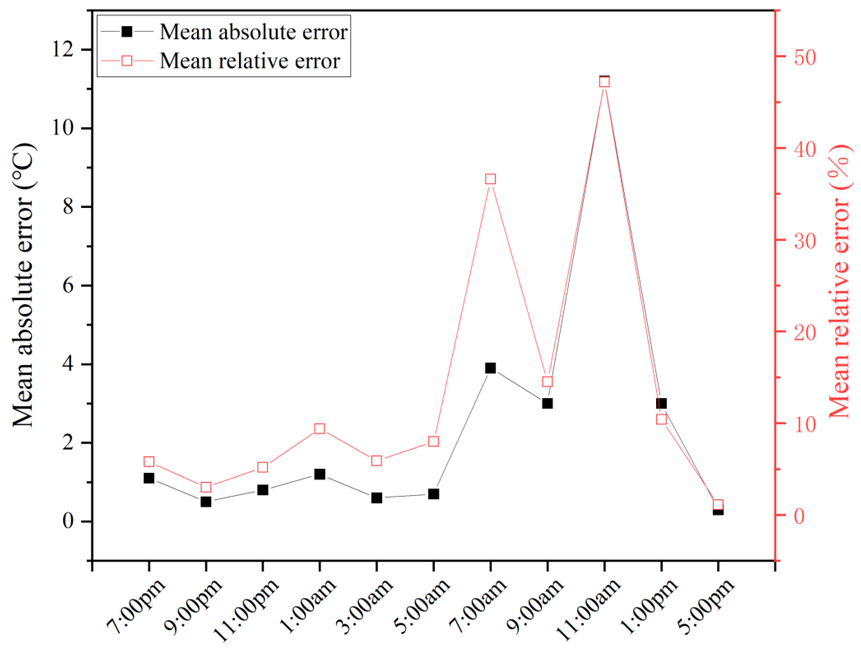
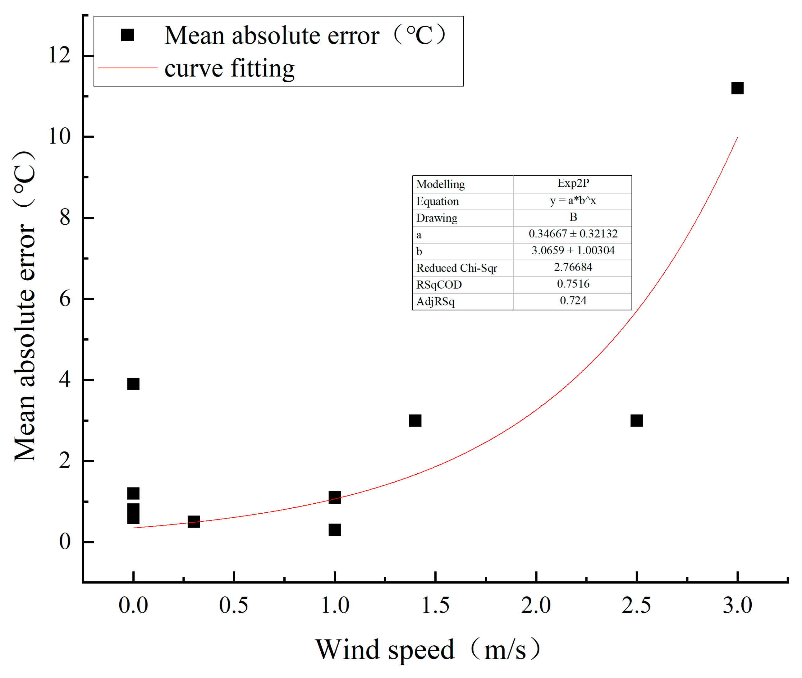
3.2. Temperature Accuracy Analysis of Ground Mining-Induced Fissures in Infrared Images

FLIR Tools software was used to determine the temperature of the ground fissures in the infrared images collected at different times and flight altitudes. The extracted temperature was compared with the measured temperature to evaluate the accuracy of extracting the temperature from the infrared images obtained at different times and flight altitudes. The extracted temperature and the error with respect to the measured temperature are provided in Table 2.
As indicated in Table 2, the mean absolute error is determined for each flight altitude at the same time. As shown in Table 2 and Figure 6, from 5:00 p.m. to 5:00 a.m., the mean absolute error of the ground fissure temperature is lower than or equal to 1.2 °C, and the relative error is lower than or equal to 9.4%. In addition, the mean absolute error from 5:00 p.m. to 5:00 a.m. is 0.7 °C, and the relative error is 5.5%, which suggests that the accuracy is relatively high. Figure 6 and Table 2 indicate that the absolute error is relatively large for the infrared images obtained from 7:00 a.m. to 1:00 p.m.; the mean absolute errors are 3.9 °C, 3.0 °C, 11.2 °C, and 3.0 °C; and the relative errors are 36.6%, 14.5%, 47.2%, and 10.4%, respectively. The average value of the mean absolute error is 5.2 °C, and that of the relative error is 27.2%, which is relatively large, especially at 11:00 a.m.
The temperature accuracy varies greatly at different times, and this finding is related to the wind speed. As indicated in Table 2, the error between the extracted and measured temperatures increases with increasing wind speed. Under low-wind conditions (wind speed ≤ 1.0 m/s), the mean absolute error is 1.1 °C, and the relative error is 9.9%. At this time, the accuracy of extracting the temperature from the infrared images is relatively high. At wind speeds greater than 1.0 m/s and lower than or equal to 2.5 m/s, the mean absolute error is 2.4 °C, and the relative error is 10.2%. At high wind speeds, such as 3 m/s at 11:00 a.m., both the absolute and relative errors are large, at 11.2 °C and 47.2%, respectively. In addition, the accuracy of extracting the temperature from the infrared images is low. As shown in Figure 7, fitting the relationship between the mean absolute error and the wind speed reveals an exponential relationship: the mean absolute error increases exponentially with the wind speed.
For UAV flight altitudes of 15, 20, 25 and 30 m, the mean absolute errors are 2.30 °C, 2.28 °C, 2.21 °C and 2.66 °C, respectively. The mean error first decreases and then increases with increasing flight altitude. The mean absolute error is the smallest at a flight altitude of 25 m, and the accuracy is higher than that at the other flight altitudes.

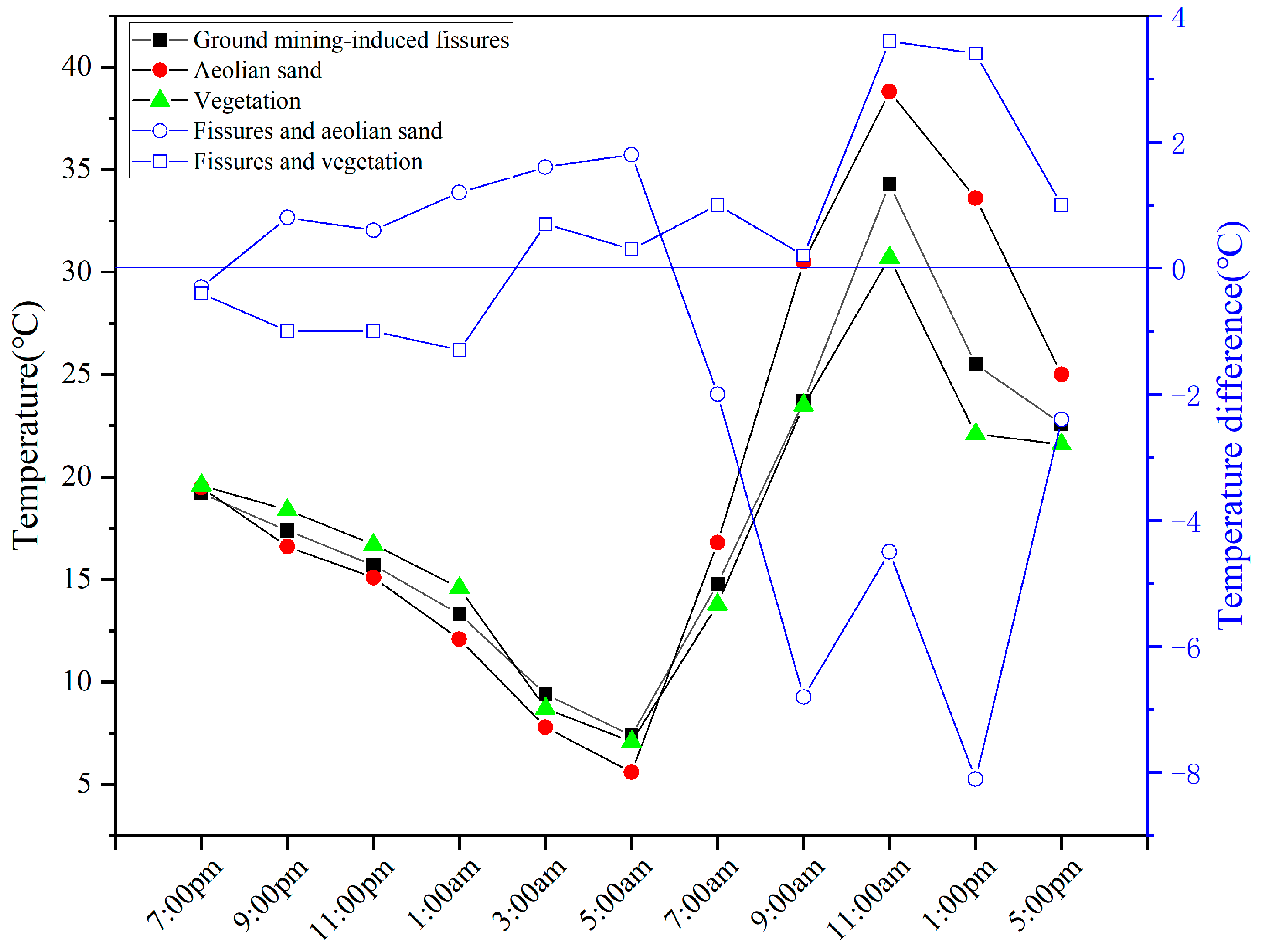
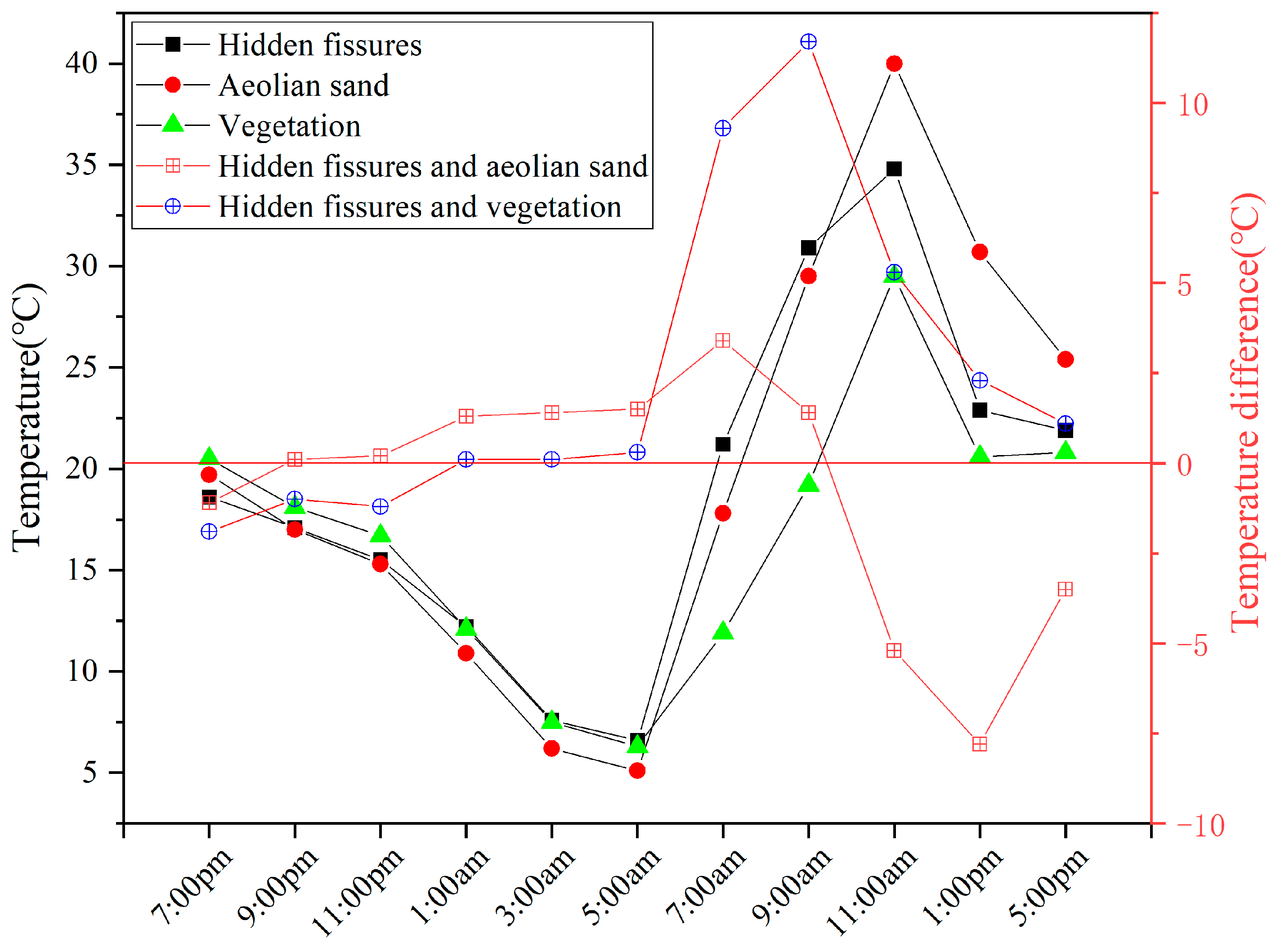
3.3. Temperature Characteristics of the Ground Mining-Induced Fissures, Aeolian Sand and Vegetation

The temperatures of the ground fissures, aeolian sand and vegetation in the infrared images were extracted by FLIR Tools software, and the temperature differences among the ground fissures, aeolian sand and vegetation were accordingly calculated. The infrared images collected at a flight altitude of 25 m were used to extract the temperature. The results are listed in Table 3.
As shown in Figure 8, the temperature curves of the ground fissures, aeolian sand and vegetation exhibited cosinusoidal characteristics from 19:00 to 17:00. Table 3 reveals that the temperatures of the three types of objects decreased from 7:00 p.m. to 5:00 a.m. At 5:00 a.m., the temperatures of the three types of objects were the lowest each day, at 5.6 °C, 7.4 °C and 8.7 °C. After 7:00 a.m., the temperatures of the three types of objects continued to increase and peaked at 11:00 a.m. to 38.8 °C, 34.3 °C, and 30.7 °C. Then, the temperatures began to decrease.
Figure 8 and Table 3 indicate that the temperature difference between the ground fissures and aeolian sand was positive from 21:00 p.m. to 5:00 a.m., and this difference basically exhibited an increasing trend. At 5:00 a.m., the temperature reached a maximum of 1.8 °C. With increasing sunlight, the radiation intensity increased, and the aeolian sand rapidly heated. The heating rate of aeolian sand is obviously greater than that of fissures. Therefore, from 7:00 a.m. to 7:00 p.m., the temperature of the former was lower than that of aeolian sand, and the temperature difference was negative. At 7:00 p.m., the absolute temperature difference between the ground fissures and aeolian sand was the smallest (−0.3 °C), making them difficult to identify. At 1:00 p.m., this difference was the largest, at −8.1 °C. Compared with those at other times, they were relatively large from 9:00 a.m. to 1:00 p.m., and the ground fissures could be easily identified. After 1:00, the temperature of the aeolian sand rapidly decreased with decreasing solar radiation intensity. The temperature difference also continuously decreased. As shown in Figure 8, from 7:00 p.m. to 1:00 a.m., the temperature difference between the ground fissures and vegetation was negative, and the absolute temperature difference continued to increase, indicating that the rate of decrease in temperature of the ground fissures was greater than that of the vegetation at this time. From 3:00 a.m. to 5:00 p.m., the temperature of the ground fissures was higher than that of the vegetation.
According to Figure 8 and Table 3, the temperatures of the ground fissures at 7:00 p.m. were lower than those of the vegetation and aeolian sand. However, their temperature differences with these materials were relatively small (−0.3 °C and −0.4 °C), and the ground fissures were relatively difficult to identify. From 9:00 p.m. to 1:00 a.m., the temperature of the ground fissures was higher than that of aeolian sand and lower than that of the vegetation. From 3:00 a.m. to 5:00 a.m., these values were greater than those of vegetation and aeolian sand. From 7:00 a.m. to 5:00 p.m., they were lower than those of aeolian sand and higher than those of vegetation. The above temperature variation regularity could be explained by the differences in the temperature increases due to the different heating rates of the ground fissures, aeolian sand and vegetation. Owing to the low specific heat capacity of aeolian sand, the temperature of aeolian sand rapidly increases during the day and rapidly decreases at night, and the resulting range of temperature variations is greater [31]. The temperature of ground fissures is affected by that of aeolian sand and heat conduction from deep mining-induced fissures; so, the range of temperature variations is smaller than that of aeolian sand. The temperature of vegetation is affected by the solar radiation intensity and transpiration. Vegetation prevents the temperature from excessively increasing by regulating water evaporation through transpiration during the day and prevents a significant decrease in temperature by reducing transpiration at night [32,33,34,35]. Therefore, the range of temperature changes was the smallest.

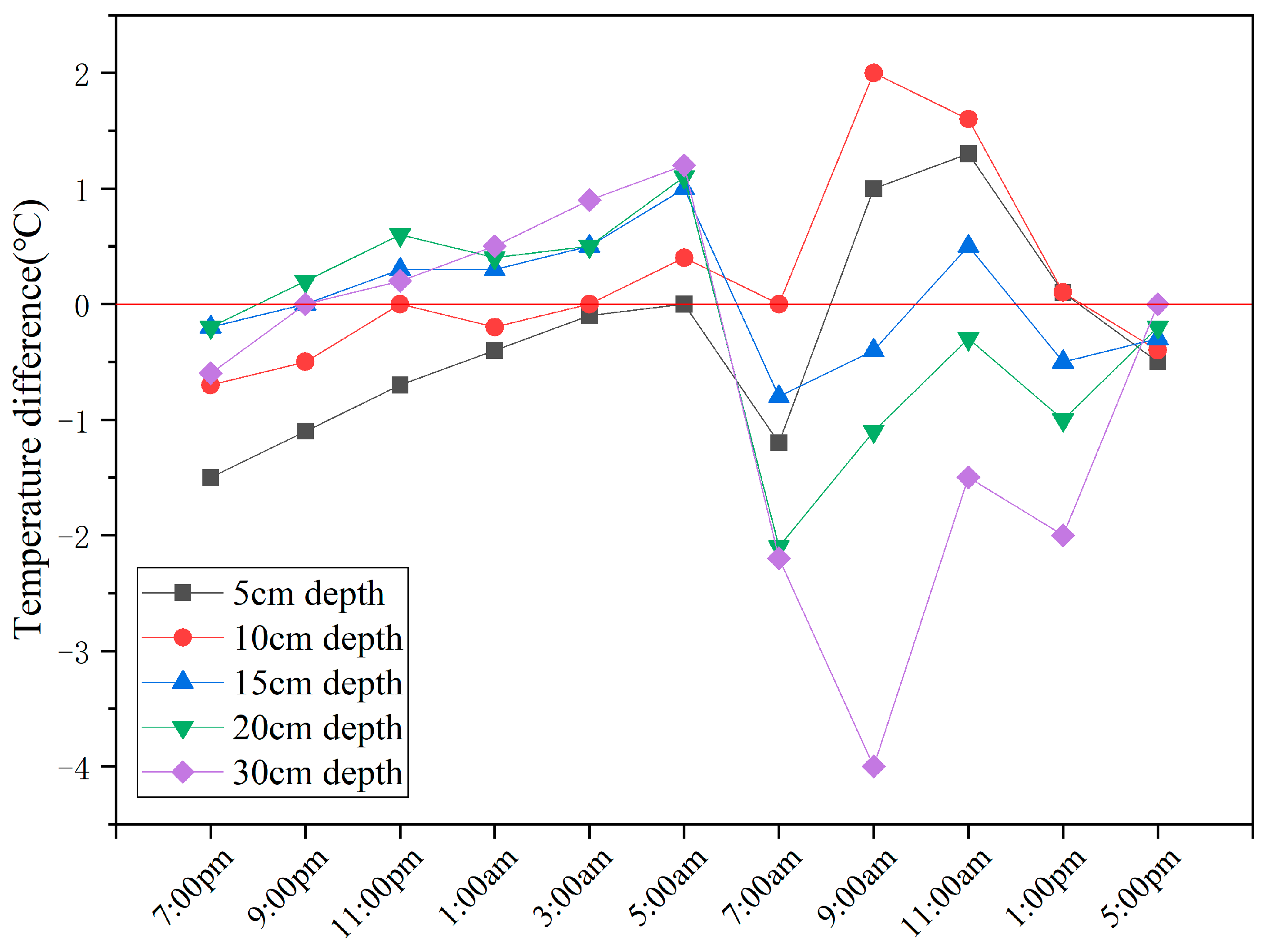
3.4. Temperature Characteristics and Analysis of Hidden Mining-Induced Fissures at Different Burial Depths

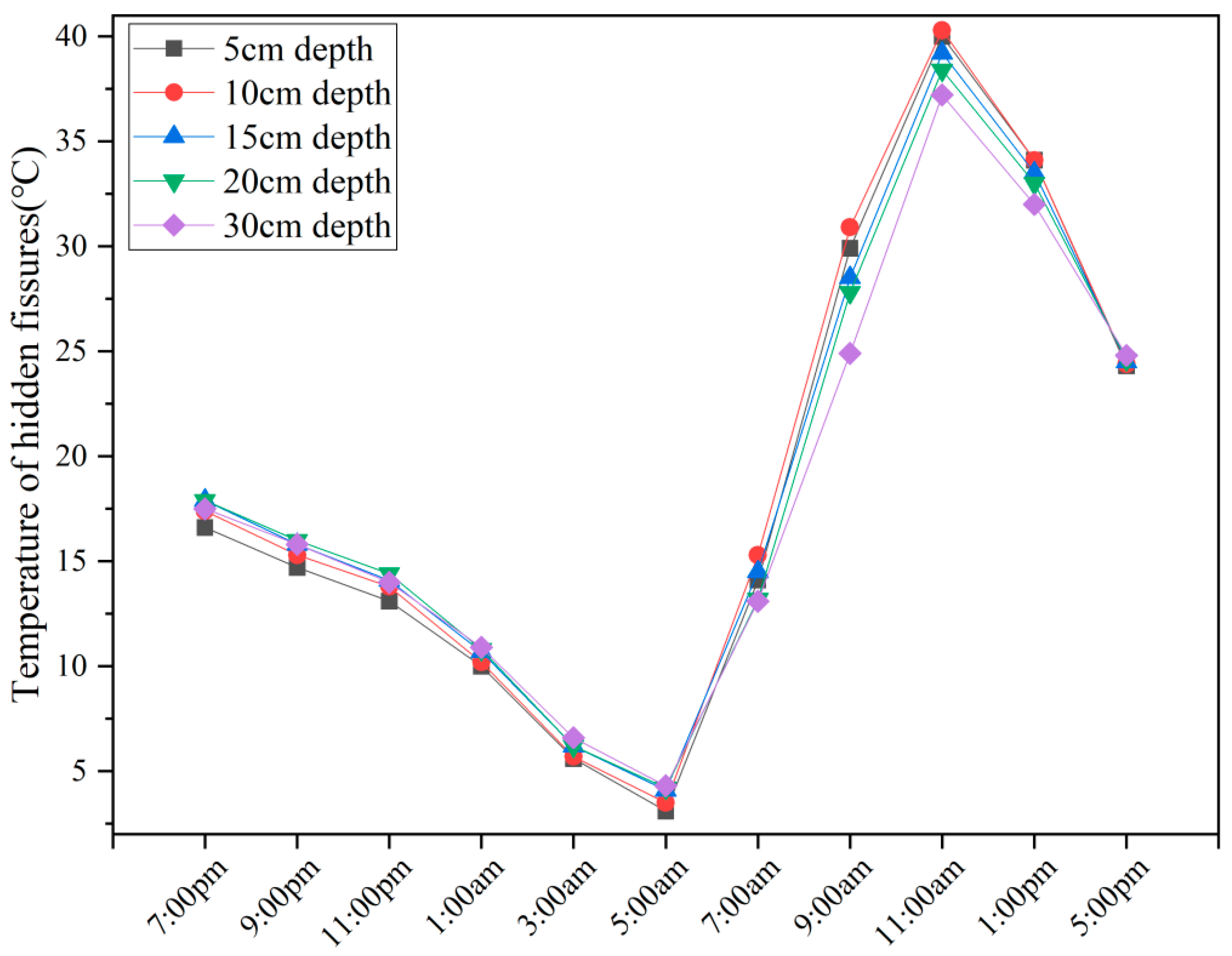
3.4.1. Temperatures of Hidden Mining-Induced Fissures at Different Burial Depths

To analyse the temperature characteristics of the hidden fissures, the temperatures of the hidden fissures at different depths in the infrared images obtained at different times were extracted. The infrared images analysed were recorded at a flight altitude of 25 m. The results are summarised in Table 4.
Figure 9 shows that the temperature curves of the hidden fissures at the same burial depth also exhibited cosinusoidal characteristics throughout the day. As shown in Figure 9 and Table 4, the temperatures at the different burial depths continuously decreased from 7:00 p.m. to 5:00 a.m. and reached the lowest value each day at 5:00 a.m. After 7:00 a.m., the radiation intensity continued to increase with increasing sunlight, and their temperatures continued to increase and reached the highest values at 11:00 a.m. each day. After 11:00 a.m., they began to decrease continuously.
Table 4 reveals that the temperatures of the hidden fissures at different burial depths at the same time differed. The temperature variation trends of the hidden fissures at the different burial depths and different times also varied, indicating that the temperature was strongly affected by the burial depth. From 7:00 p.m. to 11:00 p.m., the temperatures first increased but then decreased with increasing burial depth. From 1:00 to 5:00 a.m., with increasing burial depth, the temperatures continuously increased. From 7:00 a.m. to 11:00 a.m., they first increased and then decreased with increasing burial depth. At 1:00 p.m., the temperatures continuously decreased with increasing burial depth. At 5:00 p.m., they increased with increasing burial depth. Analysis of the temperature characteristics revealed that under the joint influence of heat conduction from mining-induced fissures and the ambient temperature, the fissure temperatures exhibited distinct characteristics. The burial depth of the hidden fissures associated with the temperature inflection point varied at different times.

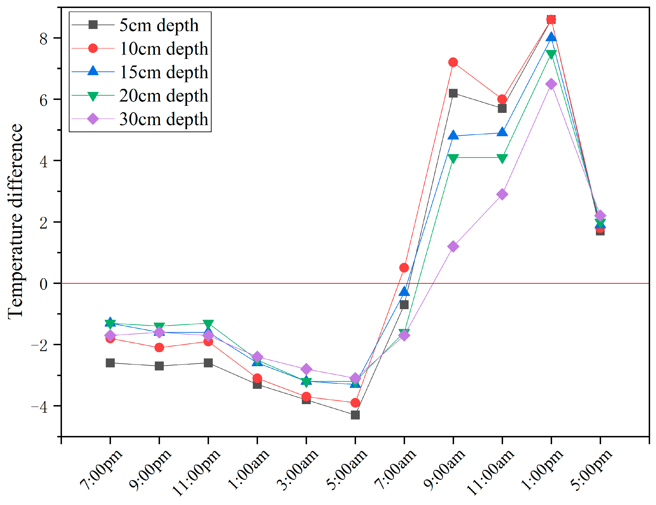
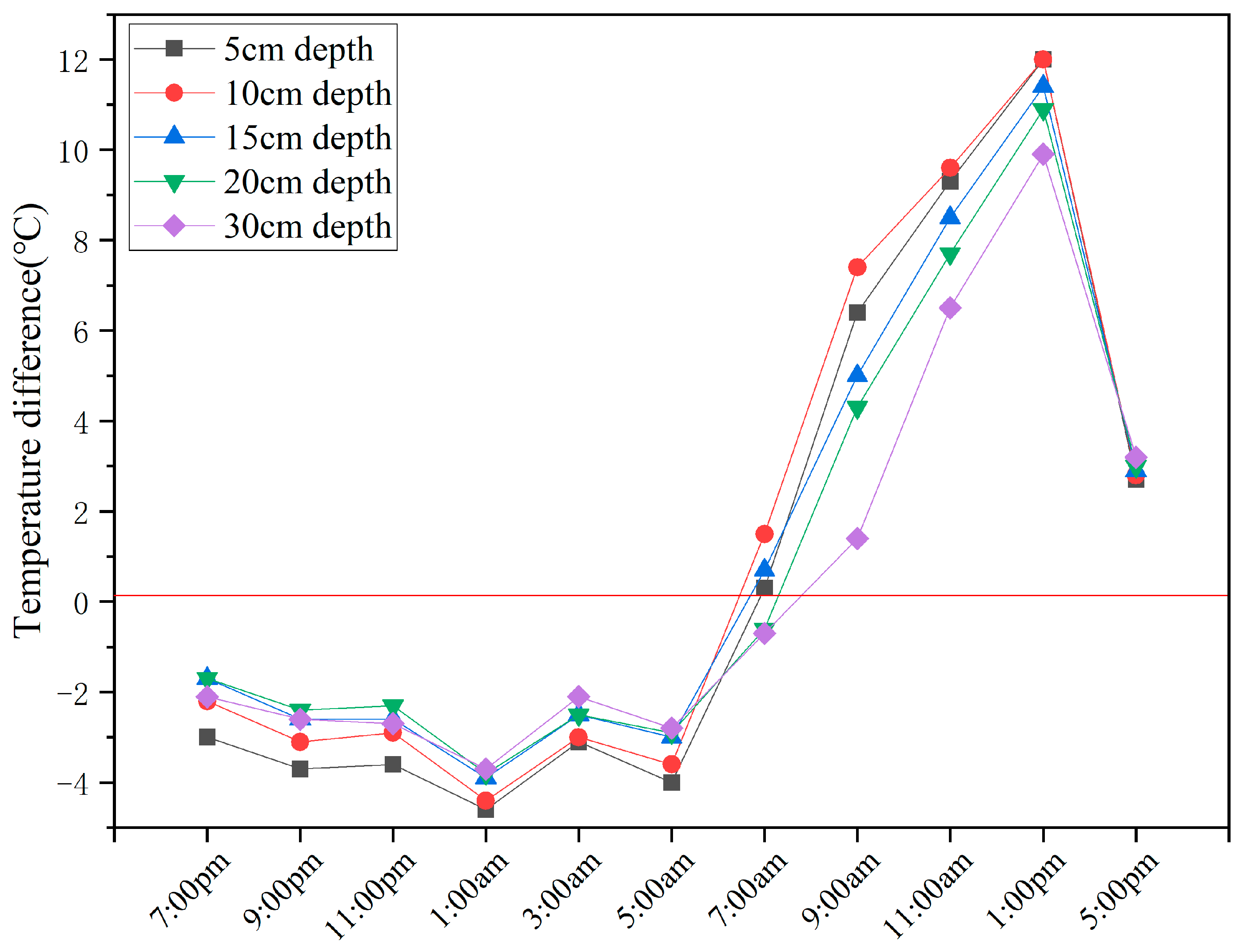
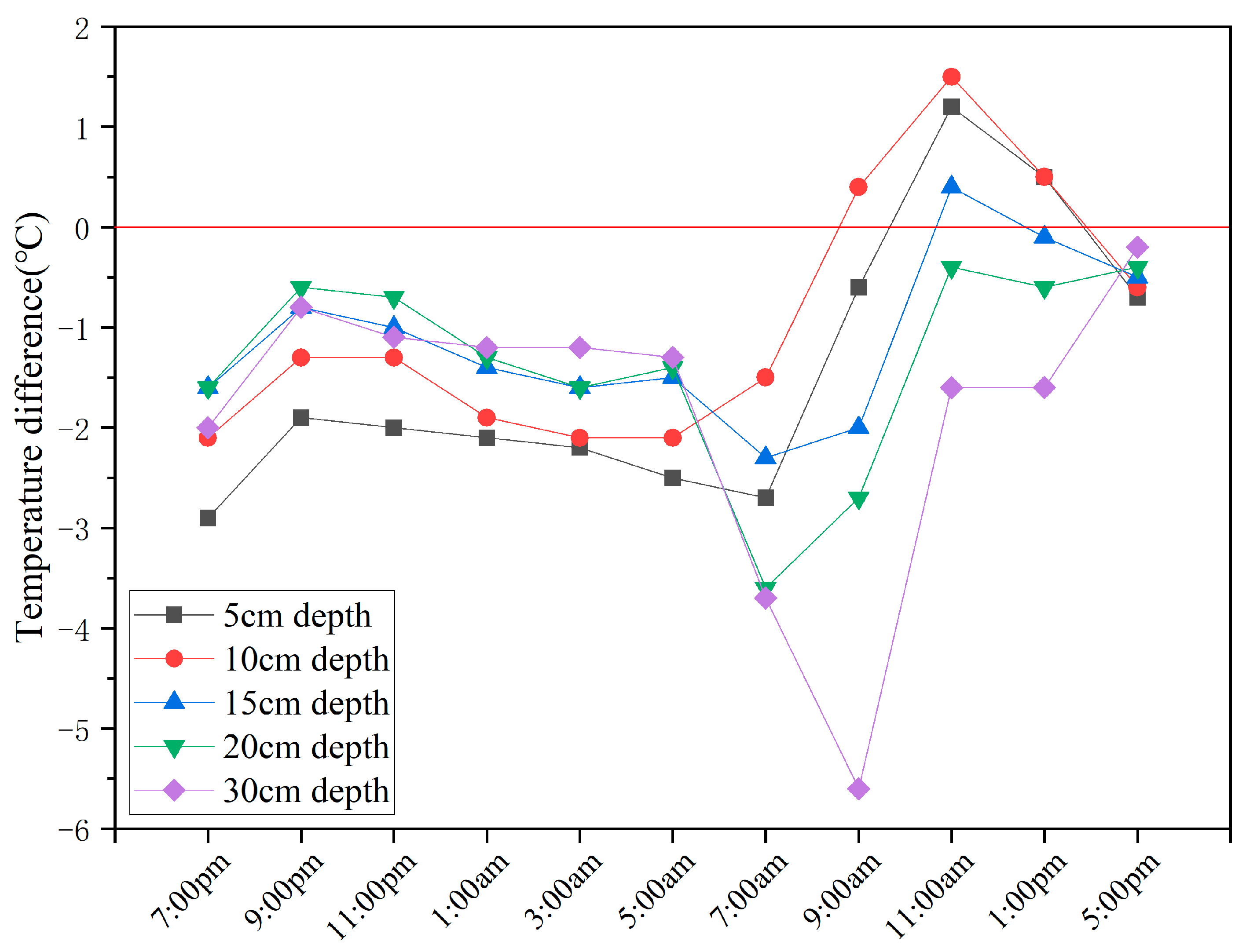
3.4.2. Temperature Differences Among the Different Ground Objects

(1)
Temperature differences between the hidden mining-induced fissures at different burial depths and ground mining-induced fissures
Table 5 lists the temperature differences between the hidden fissures at different burial depths and ground fissures at different times. As shown in Figure 10 and Table 5, these differences at night significantly diverged from the daytime values. From 7:00 p.m. to 5:00 a.m., they were negative, indicating that the temperatures of the hidden fissures at the different burial depths were lower than those of the ground fissures. The differences varied with both depth and time. From 7:00 p.m. to 11:00 p.m., the absolute temperature differences first decreased but then increased with increasing burial depth. From 1:00 a.m. to 5:00 a.m., with increasing burial depth, the absolute temperature differences continuously decreased. At 5:00 a.m., the temperature differences reached minimum values of −4.3 °C, −3.9 °C, −3.3 °C, −3.2 °C and −3.1 °C. However, compared with their temperature differences at the same burial depth at the other times during the night, the absolute value was the largest. From 7:00 a.m. to 11:00 a.m., with increasing burial depth, the temperature differences first increased but then decreased. At 7:00 a.m., the solar radiation intensity increased with increasing sunlight, and the temperature of aeolian sand quickly increased. The change in the temperature difference between the two types of objects is relatively complex under the joint influence of heat conduction from mining-induced fissures and solar radiation intensity. For the hidden fissures at a burial depth of 10 cm, the temperature difference was positive, whereas those of the others were negative. The results indicate that the influence of the solar radiation intensity on the temperature of the hidden fissures buried at a depth of 10 cm was greater than that on the temperature of the ground fissures, but the opposite was true at the other depths. At 1:00 p.m., the temperature difference continued to decrease with increasing burial depth. At this time, the daily temperature difference reached maximum values of 8.6 °C, 8.6 °C, 8.0 °C, 7.5 °C and 6.5 °C. However, the opposite trend was observed at 5:00 p.m. With increasing burial depth, the temperature difference also increased.
In summary, the temperature difference between the hidden fissures and ground fissures varied with burial depth and time. In this work, the temperatures of the hidden fissures at different burial depths were lower than those of the ground fissures at night. In contrast, the temperatures of the hidden fissures at the different burial depths were greater than those of the ground fissures except at 7:00 a.m. during the day. The main reason is that the upper layer of the hidden fissure is sandy soil, which has a low specific heat capacity, leading to rapid heating and cooling. However, the temperature of ground fissures is affected by heat conduction from deep mining-induced fissures and solar radiation, and the temperature increases and decreases more slowly than that of sandy soil does. The difference in temperature indicates that the temperature of the hidden fissures at different burial depths is affected by burial depth, heat conduction from mining-induced fissures and solar radiation. The critical burial depths at the turning points of the temperature difference curves also vary over time under the joint influence of heat conduction from mining-induced fissures and solar radiation.
(2)
Temperature differences between the hidden mining-induced fissures at different burial depths and vegetation
Table 6 provides the temperature differences between the hidden fissures at the different burial depths and the vegetation at the different times. Figure 10 and Figure 11 show that the variation in the temperature difference between the hidden fissures at the different burial depths and vegetation was similar to that observed for ground fissures. From 7:00 p.m. to 5:00 a.m., the temperature differences were negative. The temperature difference varied at the different burial depths, while the temperature difference trend also varied at the different times. From 7:00 p.m. to 11:00 p.m., the absolute temperature difference first decreased but then increased with increasing burial depth. At a burial depth of 20 cm, the absolute temperature difference was the smallest (−2.4 °C and −2.3 °C) at 9:00 p.m. and 11:00 p.m., indicating that the critical burial depth was 20 cm under the combined influence of heat conduction from mining-induced fissures and the environmental temperature. From 1:00 a.m. to 5:00 a.m., the absolute temperature difference continuously decreased with increasing burial depth. At 1:00 a.m., the absolute temperature differences were the greatest. At 7:00 a.m., the temperature difference between the hidden fissures buried at depths of 5, 10 and 15 cm and the vegetation was positive, whereas the temperature difference was negative at burial depths of 20 and 30 cm. Overall, the absolute temperature difference was small, especially at burial depths of 5, 15, 20 and 30 cm. From 9:00 a.m. to 5:00 p.m., the temperature differences were positive and relatively large, which is convenient for distinguishing hidden fissures from vegetation. The temperature difference varied with burial depth.
In conclusion, the variation in the temperature difference between the hidden fissures and vegetation was similar to that of the ground fissures. The temperature difference and rule of change varied with burial depth. In this work, the temperature of the hidden fissures at the different burial depths was lower than that of the vegetation at night and higher than that of the vegetation during the day, except at 7:00 a.m. The reason for this finding is that due to vegetation transpiration, the temperature of vegetation increases and decreases more slowly than that of sandy soil does, which has a low specific heat capacity.
(3)
Temperature differences between the hidden mining-induced fissures at different burial depths and aeolian sand
As shown in Figure 12 and Table 7, the temperature difference between the hidden fissures and aeolian sand is complex. From 7:00 p.m. to 5:00 a.m., the temperature differences with respect to aeolian sand were negative. The temperature difference and rule of change varied with burial depth. From 7:00 p.m. to 11:00 p.m., the absolute temperature difference first decreased but then increased with increasing burial depth. At 9:00 p.m. and 11:00 p.m., the absolute temperature differences between the hidden fissures buried at 20 cm and aeolian sand were the smallest, indicating that the critical burial depth was 20 cm under the combined influence of heat conduction from mining-induced fissures and the environmental temperature. From 1:00 a.m. to 5:00 a.m., the absolute temperature difference continuously decreased with increasing burial depth. The absolute temperature difference was greater than that at the other times at night. At night, the temperature difference was negative, indicating that the temperature of the hidden fissures was lower than that of aeolian sand. However, the temperature of the ground fissures was greater than that of aeolian sand. The reason for this finding is that the layer covering the hidden fissures is sand, whereas the surface layer of aeolian sand contains a small amount of vegetation, which leads to differences in the specific heat capacity. The temperature of a hidden fissure is affected by heat conduction from mining-induced fissures and varies with burial depth. At 7:00 a.m., the temperature difference was negative. The absolute temperature difference first decreased but then increased, and the temperature difference was relatively large. At 9:00 a.m., the absolute temperature difference first decreased but then increased. At 11:00 a.m., the absolute temperature difference first increased, and then decreased and increased again. At 1:00 p.m., with increasing burial depth, the absolute temperature difference first decreased but then increased. At 5:00 p.m., the absolute temperature difference continued to decrease with increasing burial depth and was of less than 1.0 °C. The main reason for the above findings is that heat conduction from mining-induced fissures and solar radiation intensity impose different effects on the temperature of the hidden fissures. The influence of the solar radiation intensity on the temperature of the hidden fissures was greater than that of heat conduction from deep mining-induced fissures at shallow burial depths. However, the opposite was true at deep burial depths.
In summary, the thermal contrast between hidden fissures and aeolian sand demonstrates spatiotemporal dependency. At night, the temperature of the hidden fissures was lower than that of aeolian sand, which was caused mainly by the difference in the specific heat capacity between the overburden sand and aeolian sand. During the day (except at 7:00 a.m.), when the burial depth is relatively shallow, the temperature of the hidden fissures (which is strongly affected by solar radiation) is greater than that of aeolian sand. At greater burial depths, the temperature of the hidden fissures is lower than that of aeolian sand due to the notable influence of heat conduction from mining-induced fissures.

3.4.3. Temperature Differences Between Hidden Mining-Induced Fissures at Different Burial Depths and Overburden Sand

In the study area, aeolian sand is covered by dry weeds, not pure sand, whereas the topsoil above the hidden fissures is pure sand. To eliminate the influences of aeolian sand and overburden sand on the identification of hidden fissures, the temperatures of the hidden fissures and those of the pure sand within the observation area were extracted. By analysing the temperature difference between the hidden fissures and sand, the influence of heat conduction from mining-induced fissures on the temperature of the hidden mining-induced fissures can be observed.
As indicated in Table 8 and Figure 13, the temperature difference between the hidden fissures at varying depths and the sand could be positive or negative at different times, which indicates that the temperature difference is highly correlated with the burial depth of the hidden fissures. These differences confirm that the fissure temperatures diverge from those of sand under combined geothermal and environmental influences, validating the infrared detectability with depth-dependent variations. As indicated in Table 8, the temperature difference between the ground fissures and sand was positive at 7:00, whereas the temperature differences between the hidden fissures at all burial depths and the ground fissures and sand were negative, indicating that the temperature of the ground fissures was greater than that of the sand and hidden fissures. It is proposed that the influence of the environmental temperature on the temperature of the hidden fissures is greater than that of heat conduction from mining-induced fissures. Figure 13 and Table 8 show that the absolute temperature differences between the hidden fissures and the ground fissures and sand first decreased but then increased with increasing burial depth. At 9:00 p.m., the temperature difference between the ground fissures and sand was positive, whereas the temperature difference between the hidden fissures and ground fissures was negative. Moreover, the temperature difference between the hidden fissures and sand changed from negative to positive with increasing burial depth. From 11:00 p.m. to 3:00 a.m., the rule of change for the temperature difference was the same as that at 9:00 p.m. At 5:00 a.m., the temperature difference between the hidden fissures and sand was greater than or equal to 0 °C and increased with increasing burial depth. The temperature difference at the 5 cm burial depth was 0 °C. The above analysis shows that hidden fissures can be readily identified except at the 5 cm burial depth. The larger the temperature difference is, the easier it is to identify hidden fissures. As shown in Figure 13, from 7:00 p.m. to 3:00 a.m., the temperature difference between the hidden fissure at the 5 cm burial depth and the sand was negative, and the absolute temperature difference gradually decreased. At a burial depth of 10 cm, the temperature difference was lower than or equal to 0 °C, and the absolute temperature difference was smaller than that at a burial depth of 5 cm. In addition, the temperature difference between the ground fissures and sand increased from 7:00 p.m. to 5:00 a.m., whereas the temperature difference between the hidden fissures buried at depths of 5 and 10 cm and the sand gradually decreased, indicating that the temperature of the hidden fissures was affected by the environmental temperature and the temperature of the ground fissures and that the impact of these factors varied with burial depth.
At 7:00 a.m., the radiation intensity increased with increasing sunlight. The temperature of the sand was greater than that of the ground fissures. The temperature difference between the hidden fissures and the sand was lower than or equal to 0 °C. The temperature difference reached 0 °C at a burial depth of 10 cm, indicating that the influence of heat conduction from mining-induced fissures on the overburden sand temperature is the same as that of the solar radiation intensity. The temperature difference at the other burial depths was negative, indicating that the influence of heat conduction from mining-induced fissures on the temperature of the overburden sand was greater than that of the solar radiation intensity. At this time, 10 cm is the critical burial depth. From 9:00 a.m. to 1:00 p.m., the temperature of the ground fissures was lower than that of the sand and the hidden fissures. With increasing burial depth, the temperature differences changed from positive to negative. At burial depths of 5 and 10 cm, the temperature difference was positive and continuously increased. This occurred because the burial depth is shallow, and the specific heat capacity of the sand is low. The thermal conductivity of mining-induced fissures at the bottom is less than that of sand; so, the temperature of the hidden fissures is greater than that of sand. At burial depths greater than 10 cm, the temperature difference gradually decreased until it became negative, and the absolute temperature difference increased with increasing burial depth. At 11:00 a.m., the solar radiation intensity was high, and the temperature reached its peak during the day. Therefore, the temperature of the hidden fissure at a burial depth of 15 cm was greater than that of the sand. At 5:00, the temperature of the hidden fissures was lower than that of the sand fissures and greater than that of the ground fissures. The temperature differences were lower than or equal to 0 °C, and the absolute temperature difference gradually decreased with increasing burial depth. At a burial depth of 30 cm, the temperature of the hidden fissures was equal to that of the sand. The reason for this finding is that the radiation intensity decreases as the sun sets, and the influence of heat conduction from mining-induced fissures increases; thus, the temperature of the hidden fissures is lower than that of the sand. Notably, the influence of heat conduction from mining-induced fissures decreases with increasing burial depth.
According to the above analysis, hidden fissures can be identified via infrared technology. However, their thermal characteristics vary significantly with burial depth and time, implying dynamic critical depths for detection. Figure 13 and Table 8 show that burial depths of 15 and 20 cm are critical points at 7:00 p.m. The absolute temperature differences are small, at −0.2 °C, making identification difficult. The temperature difference at the other depths is relatively large, so hidden fissures can be readily identified. At 9:00 p.m., the critical burial depth was 15 cm. When the burial depth is of less than 15 cm, the temperature difference is negative. When the burial depth is greater than 15 cm, the temperature difference is greater than or equal to 0 °C. However, when the temperature difference is small (except at a burial depth of 5 cm), hidden fissures are difficult to identify. From 11:00 p.m. to 3:00 a.m., a burial depth of 10 cm was the critical depth. The temperature of the hidden fissures at burial depths greater than 10 cm is greater than that of the sand and lower than that of the ground fissures, whereas the temperature of the hidden fissures at burial depths of less than 10 cm is lower than that of the sand. Therefore, the hidden fissure at a burial depth of 10 cm was difficult to identify during this period. Theoretically, hidden fissures at other burial depths can be identified because of temperature differences. However, in practice, they cannot be easily identified because of the small absolute temperature differences. At 5:00 a.m., the 5 cm layer was undetectable, in contrast with its deeper counterparts. At 7:00 a.m., the 10 cm layer had equilibrated with sand, while the remaining depths showed detectable differences. At 9:00 a.m. and 1:00 p.m., the temperature difference between the hidden fissure at the 10–15 cm burial depth and the sand was 0 °C. The hidden fissures within this burial depth range could not be identified, whereas those at the other burial depths could be identified. At 11:00 a.m., the critical burial depth was between 15 and 20 cm. The hidden fissure at this burial depth could not be identified because of a temperature difference of 0 °C with sand, whereas other depths permitted identification. At 5:00 p.m., the temperature of the 30 cm layer matched that of the sand, making the fissure undetectable at depths greater than 30 cm. Fissures at shallower depths (5–20 cm) also presented challenges due to reduced contrast.
In summary, hidden fissures can be identified by infrared technology. These temperature differences are highly correlated with burial depth. Therefore, whether hidden fissures can be identified is directly related to burial depth, and the burial depth of hidden fissures can vary with monitoring time.

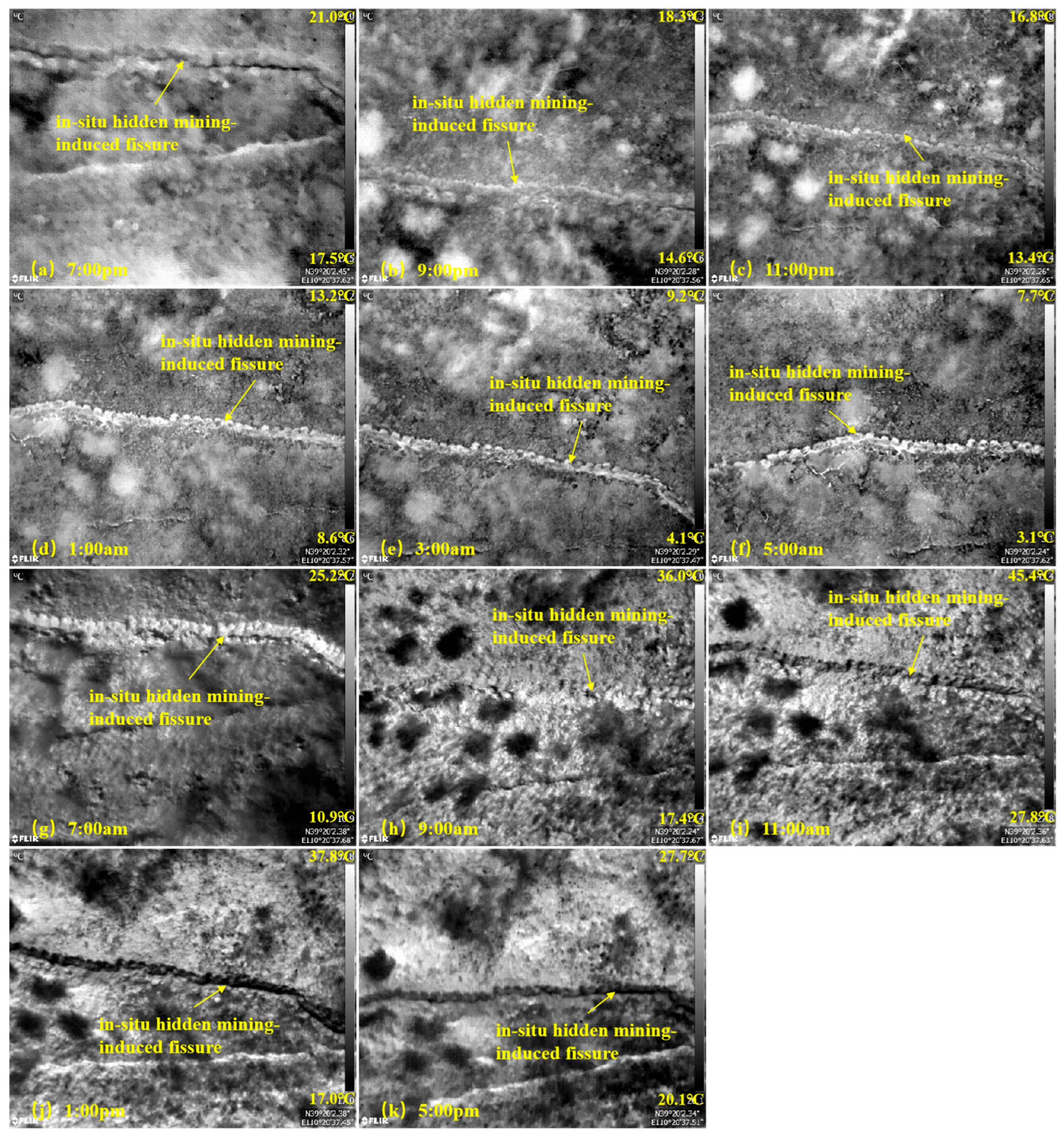
3.5. Identification Results of In Situ Hidden Mining-Induced Fissures

3.5.1. Infrared Images of the In Situ Hidden Mining-Induced Fissures

A UAV equipped with a high-definition infrared camera was deployed to continuously observe the in situ hidden fissures. The collected infrared images are shown in Figure 14. Figure 14a–k shows infrared images obtained at 7:00 p.m., 9:00 p.m., 11:00 p.m., 1:00 a.m., 3:00 a.m., 5:00 a.m., 7:00 a.m., 9:00 a.m., 11:00 a.m., 1:00 p.m., and 5:00 p.m. The locations of the in situ hidden fissures are marked in Figure 14.
As shown in Figure 14, at 7:00 p.m., the colour of the in situ hidden fissures is darker than that of aeolian sand. Therefore, in situ hidden fissures can be successfully identified. At 9:00 p.m. and 11:00 p.m., the vegetation is white, whereas the colour of the in situ hidden fissures is slightly brighter than that of aeolian sand. Therefore, in situ hidden fissures cannot be easily identified at this time. From 1:00 a.m. to 5:00 a.m., the in situ hidden fissures and vegetation are bright white, whereas the colour of the in situ hidden fissures becomes brighter over time. The colour of the aeolian sand is dark. The in situ hidden fissures and aeolian sands exhibit high colour contrast; so, the in situ hidden fissures are clear and can be readily identified during this period. At 7:00 a.m., the colours of the vegetation and aeolian sand are dark. Although the in situ hidden fissures are bright white, the outline is unclear. This may have occurred because the in situ hidden fissures were buried, resulting in a lack of pure sand near the fissures. The radiation intensity increases with increasing sunlight at 7:00 a.m., while the specific heat capacity of the sand is low. As a result, the temperature of sand is significantly greater than that of aeolian sand. Therefore, the sand is bright white, which adversely affects the identification of in situ hidden fissures. At 9:00 a.m., the colour of the vegetation is dark, whereas the in situ hidden fissures and aeolian sand are white. Although the colour of the in situ hidden fissures is slightly lighter than that of aeolian sand, the contours of the in situ hidden fissures are blurred and cannot be readily identified. From 11:00 a.m. to 5:00 p.m., the colours of the in situ hidden fissures and vegetation are dark, whereas the aeolian sand is bright white. The colours of the in situ hidden fissures and aeolian sands differ greatly, resulting in clear contours of the in situ hidden fissures. Therefore, the in situ hidden fissures can easily be distinguished from the surrounding environment, especially at 1:00 p.m. (as shown in Figure 14j).
A comparison of the infrared images of the in situ hidden fissures collected at different times reveals that the in situ hidden fissures in the infrared images from 1:00 a.m. to 5:00 a.m. are easy to identify because of their prominent colour (bright white) and clear contours. From 11:00 a.m. to 7:00 p.m., the colour of the in situ hidden fissures is dark and contrasts greatly with that of the surrounding ground objects. Therefore, in situ hidden fissures can also be identified.

3.5.2. Temperature Characteristics and Analysis of In Situ Hidden Mining-Induced Fissures

As shown in Figure 14, the main types of ground objects in the study area are hidden fissures, aeolian sand and vegetation. FLIR Tools software was used to extract the temperatures of the in situ hidden fissures, aeolian sand and vegetation in the infrared images, and the temperature difference was accordingly calculated. The results are listed in Table 9.
As shown in Figure 15, from 5:00 to 7:00 p.m., the temperature of the in situ hidden fissures exhibits cosinusoidal characteristics, which conforms with the patterns of the changes in temperature of aeolian sand and vegetation. The data in Table 9 indicate that their temperature decreased from 7:00 p.m. to 5:00 a.m., reaching a nocturnal minimum of 6.6 °C at 5:00 a.m. The temperature then increased from 7:00 a.m. to 11:00 a.m., peaking at 34.8 °C, before decreasing again. As shown in Figure 15 and Table 9, the temperature difference between the in situ hidden fissures and aeolian sand at 9:00 p.m. and 9:00 a.m. is positive. From 9:00 p.m. to 7:00 a.m., the temperature difference tends to increase. From 11:00 a.m. to 7:00 p.m., the temperature difference between the in situ hidden fissures and aeolian sand is negative. The absolute temperature difference first increases but then decreases. The temperature difference between the in situ hidden fissures and aeolian sand is positive at night and negative during the day (except at 7:00 and 9:00 a.m.). The main reason for this difference is that the temperature of mining-induced fissures is greater than that of aeolian sand at night. Under the influence of continuous heat conduction from mining-induced fissures, the temperature of in situ hidden fissures is greater than that of aeolian sand. During the day, the temperature of mining-induced fissures is lower than that of aeolian sand, whereas the temperature of in situ hidden fissures is lower than that of aeolian sand owing to the low temperature of mining-induced fissures. According to Table 4, the temperatures of the mining-induced fissures at 7:00 a.m. and 9:00 a.m. are lower than those of aeolian sand, whereas the temperatures of the in situ hidden fissures are greater than those of aeolian sand, as indicated in Table 9. It is proposed that the overburden material of in situ hidden fissures is pure sand, whereas aeolian sand contains some vegetation. Moreover, the exposed sand resulting from the burial of the mining-induced fissures is adjacent to the fissures (as shown in Figure 14g,h), and the oblique angle of the sun directly impacts the exposed sand at this time. Therefore, the temperature of the overburden sand is greater than that of the aeolian sand. The high temperature of sand dominates the temperature of in situ hidden fissures, which notably influences the identification of in situ hidden fissures.
A comparison of the temperature differences between the hidden fissures and aeolian sand in Table 7 reveals that the variation in the temperature difference between the in situ hidden fissures and aeolian sand changes substantially. However, a comparison of the temperature differences between the hidden fissures and sand (Table 8) reveals that, except at 7:00 and 9:00 a.m., the variation in the temperature difference between the in situ hidden fissures and aeolian sand is the same as that in the temperature difference between the hidden fissures at the 20 cm burial depth and the sand in the experiment. However, there is a large temperature difference between the two types of objects. First, the hidden fissures in the experiment are small. Notably, the hidden fissures at the different burial depths are relatively small (approximately 60–70 cm long and 30–40 cm wide). There is a certain distance between the hidden fissures at different burial depths, which leads to an open temperature environment on both sides of the hidden fissures and indirectly affects heat conduction from the mining-induced fissures. Second, the burial depth of in situ hidden fissures is not strictly controlled. Notably, the burial depth of in situ hidden fissures differs slightly at different positions, which leads to temperature differences.
As shown in Figure 15 and Table 9, the temperature difference between the in situ hidden fissures and vegetation is negative from 7:00 p.m. to 11:00 p.m. From 1:00 a.m. to 5:00 p.m., the temperature differences are positive. At 7:00 p.m., the temperatures of the in situ hidden fissures are lower than those of aeolian sand and vegetation, and the temperature differences reach −1.1 °C and −1.9 °C, respectively. At 9:00 p.m. and 11:00 p.m., the temperature of the in situ hidden fissures is greater than that of aeolian sand but lower than that of the vegetation. At 3:00 a.m. and 5:00 a.m., the temperature of the in situ hidden fissures was greater than that of the vegetation and aeolian sand. At 7:00 a.m. and 9:00 a.m., the temperature of the in situ hidden fissures was greater than that of aeolian sand and vegetation. From 11:00 a.m. to 5:00 p.m., the temperature of the in situ hidden fissures is lower than that of aeolian sand but greater than that of the vegetation. A comparison of the temperature difference characteristics of the ground fissures, aeolian sand and vegetation (Table 3) reveals that the trends of the temperature differences for the three types of ground objects at the other times are the same, except at 1:00 a.m., 7:00 a.m. and 9:00 a.m. The reasons for the difference in temperature between 7:00 a.m. and 9:00 a.m. are provided above. The variation in the temperature difference at 1:00 a.m. may be caused by the difference in vegetation in the selected infrared images when extracting the vegetation temperature.
In summary, under the research conditions in this work, except at 7:00 a.m. and 9:00 a.m., the variations in the temperatures of the in situ hidden fissures, aeolian sand and vegetation are equivalent to those in the temperatures of the ground fissures, indicating that the temperature of the hidden fissures at certain burial depths can be affected by mining-induced fissures through heat conduction. The rule of change in the temperature difference between the in situ hidden fissures and aeolian sand is the same as that in the temperature difference between the hidden fissures buried at 20 cm and the sand in the experiment. Comparing the temperature differences between the in situ hidden fissures and aeolian sand and vegetation at different times reveals that in situ hidden fissures are easy to identify because of the large temperature differences from 1:00 a.m. to 5:00 a.m. and from 11:00 a.m. to 7:00 p.m.
While this study validates UAV infrared thermography as a reliable tool for the detection of hidden fissures (≤30 cm) in arid environments, several limitations should be noted. The performance of the method depends on thermal contrast, which can be reduced in extreme weather conditions (e.g., heavy rainfall or snow cover), in different seasonal conditions, or in deeper fissures where heat transfer is attenuated. In addition, vegetation is sparse in semiarid regions, but in densely vegetated environments, large amounts of vegetation may mask thermal anomalies and cause greater interference in the identification of fissures. To address these limitations, future research should prioritise multisensor synergies (e.g., combining infrared with lidar or multispectral imaging) and advanced image processing techniques to improve the detection accuracy for vegetation cover or dynamically changing terrain; training adaptive machine learning algorithms on seasonal thermal datasets to optimise fissure identification under variable environmental conditions; and the use of adaptive machine learning algorithms for fissure identification in different geological environments (e.g., systematic experiments to quantify burial depth limits and calibrate predictive heat transfer models). These advances will further promote UAV infrared thermography as an all-weather solution for the identification of hidden fissures in mining areas.

4. Conclusions

To explore the spatiotemporal variation in the temperature of hidden mining-induced fissures and the feasibility of identifying these types of fissures via infrared technology, a UAV equipped with a thermal imager was deployed to identify hidden mining-induced fissures at different burial depths above the No. 52605 working face of the Daliuta mine in Shendong. In situ hidden mining-induced fissures were continuously monitored at the same time. By analysing the temperature characteristics of the hidden and ground mining-induced fissures, aeolian sand and vegetation, the following conclusions were drawn:
(1)
A UAV equipped with an infrared camera was used to observe hidden mining-induced fissures around the clock. The results demonstrated that hidden mining-induced fissures could be effectively identified via infrared technology. The experimental results revealed that the temperature differences among the hidden mining-induced fissures, aeolian sand and vegetation greatly vary with burial depth at various times. Therefore, hidden mining-induced fissures at certain burial depths are difficult to identify. According to the identification of in situ hidden mining-induced fissures, in situ hidden mining-induced fissures can be easily identified from 1:00 to 5:00 a.m. and from 11:00 a.m. to 7:00 p.m.
(2)
The temperatures of the hidden mining-induced fissures, ground mining-induced fissures, aeolian sand and vegetation at different times of the day exhibited cosinusoidal curve characteristics and were positively correlated with atmospheric temperature changes. From 7:00 p.m. to 5:00 a.m., the temperatures of the four types of ground objects continuously decreased. At 5:00 a.m., the temperature reached its lowest value. From 7:00 to 11:00 a.m., the temperature continued to increase and reached a peak value. After 11:00 a.m., the temperature continuously decreased.
(3)
The temperature of hidden mining-induced fissures is highly correlated with burial depth. The temperature of hidden mining-induced fissures is affected by both the ambient temperature and heat conduction from mining-induced fissures. The temperature of hidden mining-induced fissures varies with burial depth. There is a certain temperature difference among the hidden mining-induced fissures, aeolian sand (sand) and vegetation. The temperature difference varied with monitoring time and burial depth. The trends of variation in the temperature difference at the different times matched those in the temperature of the hidden mining-induced fissures. The burial depth at the point at which the temperature difference trend changed varied with monitoring time.
(4)
Except at 7:00 and 9:00 a.m., the temperatures of the in situ hidden mining-induced fissures were positively correlated with those of the ground mining-induced fissures in this study. The rule of variation in the temperature difference between the in situ hidden mining-induced fissures and aeolian sand matched that in the temperature difference between the hidden mining-induced fissure at a burial depth of 20 cm and the sand in the experiment. As the boundary conditions of the hidden mining-induced fissures in this experiment should still be improved, the burial depth of the in situ hidden mining-induced fissures was unknown, and the temperature difference fluctuated.

Author Contributions

Conceptualisation, Y.-X.Z.; methodology, Y.-X.Z. and D.X.; software, K.-N.Z.; investigation, D.X., C.-W.L. and P.L.; data curation, D.X. and K.-N.Z.; writing—original draft preparation, D.X.; writing—review and editing, D.X. and Y.-X.Z.; project administration, P.L.; funding acquisition, Y.-X.Z. All authors have read and agreed to the published version of the manuscript.

Funding

This research was funded by the National Natural Science Foundation of China (Nos. U1910206 and 51874312) and the Key Scientific and Technological Research Projects of the National Energy Group (No. GJNY-21-26).

Data Availability Statement

The original contributions presented in this study are included in this article. Further inquiries can be directed to the first author.

Conflicts of Interest

Author Duo Xu and Peng Li were employed by the company Shendong Coal Group Co., Ltd. The remaining authors declare that the research was conducted in the absence of any commercial or financial relationships that could be construed as a potential conflict of interest.

References

  1. Bi, Y.; Zhang, J.; Song, Z.; Wang, Z.; Qiu, L.; Hu, J.; Gong, Y. Arbuscular Mycorrhizal Fungi Alleviate Root Damage Stress Induced by Simulated Coal Mining Subsidence Ground Fissures. Sci. Total Environ. 2019, 652, 398–405. [Google Scholar] [CrossRef] [PubMed]
  2. Liu, H.; Deng, K.; Zhu, X.; Jiang, C. Effects of Mining Speed on the Developmental Features of Mining-Induced Ground Fissures. Bull. Eng. Geol. Environ. 2019, 78, 6297–6309. [Google Scholar] [CrossRef]
  3. Zhang, C.; Zhao, Y.; He, X.; Guo, J.; Yan, Y. Space-Sky-Surface Integrated Monitoring System for Overburden Migration Regularity in Shallow-Buried High-Intensity Mining. Bull. Eng. Geol. Environ. 2021, 80, 1403–1417. [Google Scholar] [CrossRef]
  4. Xu, J.; Zhu, W.; Xu, J.; Wu, J.; Li, Y. High-Intensity Longwall Mining-Induced Ground Subsidence in Shendong Coalfield, China. Int. J. Rock Mech. Min. Sci. 2021, 141, 104730. [Google Scholar] [CrossRef]
  5. Bi, Y.; Xie, L.; Wang, J.; Zhang, Y.; Wang, K. Impact of Host Plants, Slope Position and Subsidence on Arbuscular Mycorrhizal Fungal Communities in the Coal Mining Area of North-Central China. J. Arid Environ. 2019, 163, 68–76. [Google Scholar] [CrossRef]
  6. Syed, T.H.; Riyas, M.J.; Kuenzer, C. Remote Sensing of Coal Fires in India: A Review. Earth-Sci. Rev. 2018, 187, 338–355. [Google Scholar] [CrossRef]
  7. Zhang, J.; Wagner, W.; Prakash, A.; Mehl, H.; Voigt, S. Detecting Coal Fires Using Remote Sensing Techniques. Int. J. Remote Sens. 2004, 25, 3193–3220. [Google Scholar] [CrossRef]
  8. Song, Z.; Kuenzer, C. Coal Fires in China over the Last Decade: A Comprehensive Review. Int. J. Coal Geol. 2014, 133, 72–99. [Google Scholar] [CrossRef]
  9. Zhou, D.; Wu, K.; Miao, X.; Li, L. Combined Prediction Model for Mining Subsidence in Coal Mining Areas Covered with Thick Alluvial Soil Layer. Bull. Eng. Geol. Environ. 2018, 77, 283–304. [Google Scholar] [CrossRef]
  10. Zhao, H.; Ma, F.; Zhang, Y.; Guo, J. Monitoring and Mechanisms of Ground Deformation and Ground Fissures Induced by Cut-and-Fill Mining in the Jinchuan Mine 2, China. Environ. Earth Sci. 2013, 68, 1903–1911. [Google Scholar] [CrossRef]
  11. Gao, J.; Hu, H. Advanced GNSS Technology of Mining Deformation Monitoring. Procedia Earth Planet. Sci. 2009, 1, 1081–1088. [Google Scholar] [CrossRef]
  12. BIAN, H.; ZHANG, S.; ZHANG, Q.; ZHENG, N. Monitoring Large-Area Mining Subsidence by GNSS Based on IGS Stations. Trans. Nonferrous Met. Soc. China 2014, 24, 514–519. [Google Scholar] [CrossRef]
  13. Abdikan, S.; Arıkan, M.; Sanli, F.B.; Cakir, Z. Monitoring of Coal Mining Subsidence in Peri-Urban Area of Zonguldak City (NW Turkey) with Persistent Scatterer Interferometry Using ALOS-PALSAR. Environ. Earth Sci. 2014, 71, 4081–4089. [Google Scholar] [CrossRef]
  14. Wang, L.; Deng, K.; Fan, H.; Zhou, F. Monitoring of Large-Scale Deformation in Mining Areas Using Sub-Band InSAR and the Probability Integral Fusion Method. J. Remote Sens. 2018, 40, 2602–2622. [Google Scholar] [CrossRef]
  15. Fan, H.D.; Cheng, D.; Deng, K.Z.; Chen, B.Q.; Zhu, C.G. Subsidence Monitoring Using D-InSAR and Probability Integral Prediction Modelling in Deep Mining Areas. Surv. Rev. 2015, 47, 438–445. [Google Scholar] [CrossRef]
  16. Zhou, D.; Wu, K.; Chen, R.; Li, L. GPS/Terrestrial 3D Laser Scanner Combined Monitoring Technology for Coal Mining Subsidence: A Case Study of a Coal Mining Area in Hebei, China. Nat. Hazards 2014, 70, 1197–1208. [Google Scholar] [CrossRef]
  17. Travelletti, J.; Malet, J.-P.; Delacourt, C. Image-Based Correlation of Laser Scanning Point Cloud Time Series for Landslide Monitoring. Int. J. Appl. Earth Obs. Geoinf. 2014, 32, 1–18. [Google Scholar] [CrossRef]
  18. Ge, Y.; Tang, H.; Gong, X.; Zhao, B.; Lu, Y.; Chen, Y.; Lin, Z.; Chen, H.; Qiu, Y. Deformation Monitoring of Earth Fissure Hazards Using Terrestrial Laser Scanning. Sensors 2019, 19, 1463. [Google Scholar] [CrossRef]
  19. Zhang, F.; Hu, Z.; Fu, Y.; Yang, K.; Wu, Q.; Feng, Z. A New Identification Method for Surface Cracks from UAV Images Based on Machine Learning in Coal Mining Areas. Remote Sens. 2020, 12, 1571. [Google Scholar] [CrossRef]
  20. Xu, D.; Zhao, Y.; Jiang, Y.; Zhang, C.; Sun, B.; He, X. Using Improved Edge Detection Method to Detect Mining-Induced Ground Fissures Identified by Unmanned Aerial Vehicle Remote Sensing. Remote Sens. 2021, 13, 3652. [Google Scholar] [CrossRef]
  21. Zhao, Y.; Zhang, K.; Sun, B.; Ling, C.; Guo, J. Heat Transfer and Temperature Evolution in Underground Mining-Induced Overburden Fracture and Ground Fissures: Optimal Time Window of UAV Infrared Monitoring. J. Min. Sci. Technol. 2024, 34, 31–50. [Google Scholar] [CrossRef]
  22. Wang, K.; Jiang, Q.; Yu, D.; Yang, Q.; Wang, L.; Han, T.; Xu, X. Detecting Daytime and Nighttime Land Surface Temperature Anomalies Using Thermal Infrared Remote Sensing in Dandong Geothermal Prospect. Int. J. Appl. Earth Obs. Geoinf. 2019, 80, 196–205. [Google Scholar] [CrossRef]
  23. Tavukcuoglu, A.; Akevren, S.; Grinzato, E. In Situ Examination of Structural Cracks at Historic Masonry Structures by Quantitative Infrared Thermography and Ultrasonic Testing. J. Mod. Opt. 2010, 57, 1779–1789. [Google Scholar] [CrossRef]
  24. Baroň, I.; Bečkovský, D.; Míča, L. Application of Infrared Thermography for Mapping Open Fractures in Deep-Seated Rockslides and Unstable Cliffs. Landslides 2014, 11, 15–27. [Google Scholar] [CrossRef]
  25. Afshani, A.; Kawakami, K.; Konishi, S.; Akagi, H. Study of Infrared Thermal Application for Detecting Defects within Tunnel Lining. Tunn. Undergr. Space Technol. 2019, 86, 186–197. [Google Scholar] [CrossRef]
  26. Zhao, Y.; Sun, B.; Liu, S.; Zhang, C.; He, X.; Xu, D.; Tang, W. Identification of Mining Induced Ground Fissures Using UAV and Infrared Thermal Imager: Temperature Variation and Fissure Evolution. ISPRS J. Photogramm. Remote Sens. 2021, 180, 45–64. [Google Scholar] [CrossRef]
  27. Antoine, R.; Fauchard, C.; Oehler, J.-F.; Joignant, P. Permeability and Voids Influence on the Thermal Signal, as Inferred by Multitemporal UAV-Based Infrared and Visible Images. J. Hydrol. 2020, 587, 124907. [Google Scholar] [CrossRef]
  28. Koganti, T.; Ghane, E.; Martinez, L.; Iversen, B.; Allred, B. Mapping of Agricultural Subsurface Drainage Systems Using Unmanned Aerial Vehicle Imagery and Ground Penetrating Radar. Sensors 2021, 21, 2800. [Google Scholar] [CrossRef]
  29. Lee, E.J.; Shin, S.Y.; Ko, B.C.; Chang, C. Early Sinkhole Detection Using a Drone-Based Thermal Camera and Image Processing. Infrared Phys. Technol. 2016, 78, 223–232. [Google Scholar] [CrossRef]
  30. Zhao, Y.; Ling, C.; Zhang, K.; Gao, Y.; Sun, B.; Wang, X. Detection of Hidden Mining-Induced Ground Fissures via Unmanned Aerial Vehicle Infrared System and Ground-Penetrating Radar. Int. J. Rock Mech. Min. Sci. 2022, 160, 105254. [Google Scholar] [CrossRef]
  31. Lu, Y.; Yu, W.; Hu, D.; Liu, W. Experimental Study on the Thermal Conductivity of Aeolian Sand from the Tibetan Plateau. Cold Reg. Sci. Technol. 2018, 146, 1–8. [Google Scholar] [CrossRef]
  32. Ling, J.; Zhang, S.-Q.; Pan, J.-L.; Lian, C.-C.; Yang, H. The Study of Transpiration Influence on Plant Infrared Radiation Character. Spectrosc. Spectr. Anal. 2012, 32, 1775–1779. [Google Scholar] [CrossRef]
  33. Luomala, E.-M.; Laitinen, K.; Sutinen, S.; Kellomäki, S.; Vapaavuori, E. Stomatal Density, Anatomy and Nutrient Concentrations of Scots Pine Needles Are Affected by Elevated CO2 and Temperature. Plant Cell Environ. 2005, 28, 733–749. [Google Scholar] [CrossRef]
  34. Reddy, K.R.; Robana, R.R.; Hodges, H.F.; Liu, X.J.; McKinion, J.M. Interactions of CO2 Enrichment and Temperature on Cotton Growth and Leaf Characteristics. Environ. Exp. Bot. 1998, 39, 117–129. [Google Scholar] [CrossRef]
  35. Raschke, K.; Hanebuth, W.F.; Farquhar, G.D. Relationship between Stomatal Conductance and Light Intensity in Leaves of Zea mays L. Derived from Experiments Using the Mesophyll as Shade. Planta 1978, 139, 73–77. [Google Scholar] [CrossRef] [PubMed]
Figure 1. Location map of the area of interest (AOI).
Remotesensing 17 01992 g001
Figure 2. Diagram of hidden mining-induced fissure development and location of the research area in the Daliuta coal mine.
Remotesensing 17 01992 g002
Figure 3. Layout of the hidden mining-induced fissure at different burial depths and its measurement.
Remotesensing 17 01992 g003
Figure 4. Image of the in situ hidden mining-induced fissure.
Remotesensing 17 01992 g004
Figure 5. Infrared images of hidden mining-induced fissures at different burial depths and different times.
Remotesensing 17 01992 g005
Figure 6. Curves of the error between the extracted and measured temperatures of the ground mining-induced fissures.
Remotesensing 17 01992 g006
Figure 7. Fitted curve of the mean absolute error vs. wind speed.
Remotesensing 17 01992 g007
Figure 8. Temperature curves of ground mining-induced fissures, aeolian sand, and vegetation and the corresponding temperature differences.
Remotesensing 17 01992 g008
Figure 9. Temperature curves of the hidden mining-induced fissures at the different burial depths.
Remotesensing 17 01992 g009
Figure 10. Curves of the temperature differences between the hidden mining-induced fissures at different burial depths and the ground mining-induced fissures at different times.
Remotesensing 17 01992 g010
Figure 11. Curves of the temperature difference between the hidden mining-induced fissures at different burial depths and vegetation at different times.
Remotesensing 17 01992 g011
Figure 12. Curves of the temperature difference between the hidden mining-induced fissures at different depths and aeolian sand at different times.
Remotesensing 17 01992 g012
Figure 13. Curves of the temperature difference between the hidden mining-induced fissures at different burial depths and the sand at different times.
Remotesensing 17 01992 g013
Figure 14. Infrared images of in situ hidden mining-induced fissures.
Remotesensing 17 01992 g014
Figure 15. Curves of the temperatures of the in situ hidden mining-induced fissures, aeolian sand, and vegetation and corresponding temperature differences.
Remotesensing 17 01992 g015
Table 1. Technical parameters and specifications of the UAV and infrared thermal imager.
Equipment NameSpecificationTechnical Parameters
DJI UAVM600 ProWeight9.5 kg with 6 TB47S
10 kg with 6 TB48S
Max takeoff weight15.5 kg
Hover precision0.5 m in the vertical direction
1.5 m in the horizontal direction
Maximum angular velocity of rotation300°/s around the pitching axis
150°/s around the course axis
Max pitching angle25°
Max speedAscent: 5 m/s
Descent: 3 m/s
Max wind speed8 m/s
Maximum horizontal speed65 km/h (no wind)
Hover time with 6 TB47SNo load: 32 min
6 kg load: 16 min
Hover time with 6 TB48SNo load: 38 min
5.5 kg load:18 min
Max flight altitude2500 m
Infrared thermal imagerDuo Pro R 336Thermal imagerUncooled vanadium oxide (VOx) microbolometer
Resolution640 × 512
Frame frequency30 Hz
Wavelength7.5–13.5 μm
NETD<50 mk@f/1.0
Temperature measurement accuracy+/−5 °C or +/−5% in the range of −25 °C to +135 °C
Size85 × 81.3 × 68.5 mm
Table 2. Differences between the extracted and measured temperatures of ground mining-induced fissures.
TimesWind Speed (m/s)Flight Altitude (m)Fissure Temperature (°C)Error (°C)Mean Absolute Error (°C)Mean Relative Error (%)
ExtractMeasured
7:00 p.m.1.01519.719.00.71.15.8
2020.71.7
2519.20.2
3017.3−1.7
9:00 p.m.0.31516.317.7−1.40.53.0
2017.5−0.2
2517.4−0.3
3017.5−0.2
11:00 p.m.0.01516.415.31.10.85.2
2017.01.7
2515.70.4
3015.40.1
1:00 a.m.0.01514.012.21.81.29.4
2013.31.1
2513.31.1
3012.80.6
3:00 a.m.0.01510.39.70.60.65.9
209.3−0.4
259.4−0.3
308.7−1.0
5:00 a.m.0.0158.88.10.70.78.0
208.30.2
257.4−0.7
307.1−1.0
7:00 a.m.0.01513.110.62.53.936.6
2014.84.2
2514.84.2
3015.24.6
9:00 a.m.1.41521.020.30.73.014.5
2022.62.3
2523.73.4
3025.75.4
11:00 a.m.3.01535.223.711.511.247.2
2035.211.5
2534.310.6
3034.811.1
1:00 p.m.2.51524.528.4−3.93.010.4
2026.7−1.7
2525.5−2.9
3025.1−3.3
5:00 p.m.1.01522.822.40.40.31.1
2022.3−0.1
2522.60.2
3022.70.3
Table 3. Extracted temperatures of ground mining-induced fissures, aeolian sand, and vegetation and temperature differences.
TimesGround Mining-Induced Fissures Temperature (°C)Aeolian Sand Temperature (°C)Vegetation Temperature (°C)Temperature Difference (°C)
Fissures and Aeolian SandFissures and Vegetation
7:00 p.m.19.219.519.6−0.3−0.4
9:00 p.m.17.416.618.40.8−1.0
11:00 p.m.15.715.116.70.6−1.0
1:00 a.m.13.312.114.61.2−1.3
3:00 a.m.9.47.88.71.60.7
5:00 a.m.7.45.67.11.80.3
7:00 a.m.14.816.813.8−2.01.0
9:00 a.m.23.730.523.5−6.80.2
11:00 a.m.34.338.830.7−4.53.6
1:00 p.m.25.533.622.1−8.13.4
5:00 p.m.22.625.021.6−2.41.0
Table 4. Extracted temperatures of the hidden mining-induced fissures at different depths and different times.
TimesTemperatures of the Hidden Mining-Induced Fissures at the Different Depths (°C)
5 cm10 cm15 cm20 cm30 cm
7:00 p.m.16.617.417.917.917.5
9:00 p.m.14.715.315.816.015.8
11:00 p.m.13.113.814.114.414
1:00 a.m.10.010.210.710.810.9
3:00 a.m.5.65.76.26.26.6
5:00 a.m.3.13.54.14.24.3
7:00 a.m.14.115.314.513.213.1
9:00 a.m.29.930.928.527.824.9
11:00 a.m.40.040.339.238.437.2
1:00 p.m.34.134.133.533.032.0
3:00 p.m.24.324.424.524.624.8
Table 5. Temperature differences between the hidden mining-induced fissures at different burial depths and the ground mining-induced fissures at different times.
TimesTemperature Difference Between the Hidden Mining-Induced Fissures and Ground Mining-Induced Fissures (°C)
5 cm10 cm15 cm20 cm30 cm
7:00 p.m.−2.6−1.8−1.3−1.3−1.7
9:00 p.m.−2.7−2.1−1.6−1.4−1.6
11:00 p.m.−2.6−1.9−1.6−1.3−1.7
1:00 a.m.−3.3−3.1−2.6−2.5−2.4
3:00 a.m.−3.8−3.7−3.2−3.2−2.8
5:00 a.m.−4.3−3.9−3.3−3.2−3.1
7:00 a.m.−0.70.5−0.3−1.6−1.7
9:00 a.m.6.27.24.84.11.2
11:00 a.m.5.76.04.94.12.9
1:00 p.m.8.68.68.07.56.5
5:00 p.m.1.71.81.92.02.2
Table 6. Temperature differences between the hidden mining-induced fissures at different burial depths and vegetation at different times.
TimesTemperature Difference Between the Hidden Mining-Induced Fissures and Vegetation (°C)
5 cm10 cm15 cm20 cm30 cm
7:00 p.m.−3.0−2.2−1.7−1.7−2.1
9:00 p.m.−3.7−3.1−2.6−2.4−2.6
11:00 p.m.−3.6−2.9−2.6−2.3−2.7
1:00 a.m.−4.6−4.4−3.9−3.8−3.7
3:00 a.m.−3.1−3.0−2.5−2.5−2.1
5:00 a.m.−4.0−3.6−3.0−2.9−2.8
7:00 a.m.0.31.50.7−0.6−0.7
9:00 a.m.6.47.45.04.31.4
11:00 a.m.9.39.68.57.76.5
1:00 p.m.12.012.011.410.99.9
5:00 p.m.2.72.82.93.03.2
Table 7. Temperature differences between the hidden mining-induced fissures at different depths and aeolian sand at different times.
TimesTemperature Difference Between the Hidden Mining-Induced Fissures and Aeolian Sand (°C)
5 cm10 cm15 cm20 cm30 cm
7:00 p.m.−2.9−2.1−1.6−1.6−2.0
9:00 p.m.−1.9−1.3−0.8−0.6−0.8
11:00 p.m.−2.0−1.3−1.0−0.7−1.1
1:00 a.m.−2.1−1.9−1.4−1.3−1.2
3:00 a.m.−2.2−2.1−1.6−1.6−1.2
5:00 a.m.−2.5−2.1−1.5−1.4−1.3
7:00 a.m.−2.7−1.5−2.3−3.6−3.7
9:00 a.m.−0.60.4−2.0−2.7−5.6
11:00 a.m.1.21.50.4−0.4−1.6
1:00 p.m.0.50.5−0.1−0.6−1.6
5:00 p.m.−0.7−0.6−0.5−0.4−0.2
Table 8. Temperature differences between the hidden mining-induced fissures at different burial depths and the ground mining-induced fissures and sand.
TimesTemperature Difference Between Ground Mining-Induced Fissures and Sand (°C)Temperature Difference Between the Hidden Mining-Induced Fissures and Sand (°C)
5 cm10 cm15 cm20 cm30 cm
7:00 p.m.1.1−1.5−0.7−0.2−0.2−0.6
9:00 p.m.1.6−1.1−0.50.00.20.0
11:00 p.m.1.6−0.70.00.30.60.2
1:00 a.m.2.9−0.4−0.20.30.40.5
3:00 a.m.3.7−0.10.00.50.50.9
5:00 a.m.4.30.00.41.01.11.2
7:00 a.m.−0.5−1.20.0−0.8−2.1−2.2
9:00 a.m.−5.21.02.0−0.4−1.1−4.0
11:00 a.m.−4.41.31.60.5−0.3−1.5
1:00 p.m.−8.50.10.1−0.5−1.0−2.0
5:00 p.m.−2.2−0.5−0.4−0.3−0.20.0
Table 9. Temperatures of the in situ hidden mining-induced fissures, aeolian sand and vegetation and temperature differences.
TimesHidden Fissures Temperature (°C)Aeolian Sand Temperature (°C)Vegetation Temperature (°C)Temperature Difference (°C)
Hidden Fissures and Aeolian SandHidden Fissures and Vegetation
7:00 p.m.18.619.720.5−1.1−1.9
9:00 p.m.17.117.018.10.1−1.0
11:00 p.m.15.515.316.70.2−1.2
1:00 a.m.12.210.912.11.30.1
3:00 a.m.7.66.27.51.40.1
5:00 a.m.6.65.16.31.50.3
7:00 a.m.21.217.811.93.49.3
9:00 a.m.30.929.519.21.411.7
11:00 a.m.34.840.029.5−5.25.3
1:00 p.m.22.930.720.6−7.82.3
5:00 p.m.21.925.420.8−3.51.1
Disclaimer/Publisher’s Note: The statements, opinions and data contained in all publications are solely those of the individual author(s) and contributor(s) and not of MDPI and/or the editor(s). MDPI and/or the editor(s) disclaim responsibility for any injury to people or property resulting from any ideas, methods, instructions or products referred to in the content.

