Article

Characteristics and Climatic Indications of Ice-Related Landforms at Low Latitudes (0°–±30°) on Mars

1
Research Center for Planetary Science, College of Earth and Planetary Sciences, Chengdu University of Technology, Chengdu 610059, China
2
CAS Center for Excellence in Comparative Planetology, Hefei 230026, China
3
Department of Earth and Space Sciences, Southern University of Science and Technology, Shenzhen 518055, China
*
Author to whom correspondence should be addressed.
Remote Sens. 2025, 17(11), 1939; https://doi.org/10.3390/rs17111939
Submission received: 31 March 2025 / Revised: 25 May 2025 / Accepted: 1 June 2025 / Published: 4 June 2025
(This article belongs to the Special Issue Planetary Geologic Mapping and Remote Sensing (Second Edition))

Abstract

:
The deposition and evolution of ice-rich materials on Martian surfaces offer valuable insights into climatic evolution and the potential driving forces behind global climate change. Substantial evidence indicates that the mid-latitudes of Mars played a crucial role in the formation and development of glacial and periglacial landforms during the Amazonian period. However, few studies have comprehensively examined ice-related landforms in the low-latitude region of Mars. Whether extensive glacial activity has occurred in the equatorial region of Mars and whether there are any potential geological records of such activities remain unclear. In this study, we analyzed remote sensing data from the Martian equatorial region (0°–±30°) and identified existing glacial/periglacial features, as well as remnant landforms of past glaciation. Our findings reveal that glaciation at low latitudes is more widespread than previously thought, with ice-related remnants extending as far equatorward as 13°N in the northern hemisphere and 19°S in the southern hemisphere, highlighting a broader latitudinal range for ice-related landforms. These landforms span multiple episodes of Martian geological history, supporting the hypothesis on the occurrence of repeated glaciation and various high-obliquity events. Evidence of dynamic interactions between ice deposition and sublimation in low-latitude regions demonstrates substantial ice loss over time, leaving ice-related remnants that provide valuable insights into Mars’ climatic evolution. Based on volumetric estimates of the concentric crater fill (CCF), the low-latitude regions of Mars may contain up to 1.05 × 10³ km3 of ice. This corresponds to a global equivalent ice layer thickness ranging from 21.7 mm (assuming a pore ice with 30% ice content) to 65.1 mm (assuming glacial ice with 90% ice content), suggesting a potentially greater low-latitude ice reservoir than previously recognized.

1. Introduction

Numerous studies have emphasized the critical role of the mid-latitudes (±30°–60°) of Mars in the formation and evolution of glacial and periglacial landforms during the Amazonian period (~3.1 Ga–present) [1,2,3,4,5]. These regions host a variety of glacial landforms (Figure 1), including lineated valley fills (LVFs), lobate debris aprons (LDAs), concentric crater fills (CCFs), and glacier-like forms (GLFs) [6,7,8,9]. Recent studies suggest that many of these landforms were formed from debris-covered glaciers, with ice contents of up to 90% [10,11]. Radar interpretation results indicate that substantial quantities of ice are preserved in the subsurface [2,12].
Ring-mold craters (RMCs) and “brain-terrain” textures are frequently observed on the surfaces of these glacial landforms. RMCs are interpreted as the result of impacts on ice-rich substrates [7,13,14], causing plastic deformation of buried ice that uplifted the crater rim into the characteristic ringed morphology. While they currently lack direct terrestrial analogs, partially collapsed pingos in permafrost regions may bear a superficial resemblance to RMCs, although their origins differ significantly. “Brain-terrain” textures appear as irregular surface patterns on features such as LDAs, LVFs, and CCFs. Although these textures resemble polygonal patterned ground in terrestrial permafrost settings, such as Alaska and Siberia, they likely form due to different mechanisms. On Earth, patterned ground typically results from seasonal freeze–thaw processes, while Martian “brain-terrain” textures are interpreted to develop via the sublimation of ice-rich materials, thermal contraction cracking, and glacio-tectonic deformation [15]. Therefore, despite morphological similarities, “brain-terrain” textures on Mars represent a cold desert, sublimation-dominated analog rather than a freeze–thaw feature. In addition, small-scale polygonal patterns are widely distributed in the mid- to high-latitude regions of Mars and are considered to be closely related to thermal contraction and differential sublimation processes [16]. In contrast, large-scale polygons may indicate the potential presence of freeze–thaw cycles [16].
Global circulation models (GCMs) suggest that Mars’ fluctuating orbital obliquity drives the periodic sublimation of polar ice, with ice being transported to equatorial regions during periods of high obliquity [17,18]. At an average obliquity of 35°, ice is primarily stabilized at mid-latitudes, whereas at higher obliquities, such as 45°, ice can extend into equatorial regions [19]. The current interglacial period has led to unstable ice-rich materials near the equator [20,21]. Mars may have experienced multiple ice ages, with glaciers at mid-latitudes forming during periods of high obliquity, particularly in the middle to late Amazonian period [22,23]. Recent studies suggest that glacier-like forms (GLFs) represent remnants of the most recent obliquity shift, providing insights into regional glaciation and revealing stratigraphic relationships [24,25]. The “brain-terrain” textures observed in mid- to high-latitude mantle polygons reflects the sequential interaction between earlier glacial-like deposition events and subsequent modification by ice-rich mantling and thermal contraction cracking, during more recent cold-climate periods [15]. These findings support the idea of repeated glaciation during high-obliquity events.
Despite extensive research on Martian ice-related features at mid-latitudes, there is a notable gap in terms of studies focusing on low-latitude regions (0°–±30°). While some evidence suggests that the equatorial regions may have experienced glacial/periglacial activity during periods of high obliquity [26,27,28], comprehensive studies documenting the ice-associated features in these areas are lacking. Previous studies have largely concentrated on mid- and high-latitude regions, where glacial features are more prominent [4,29,30,31,32]. For example, large tropical glaciers in regions such as Tharsis Montes and Olympus Mons [33], as well as candidate ice-rich materials in Sinus Sabaeus [34], may have formed during early high-obliquity periods, but the overall extent of ice-related landforms at low latitudes remains unclear. Consequently, it remains unclear whether the absence of documented ice-related features at low latitudes indicates a lack of glacial activity or if these features have been overlooked due to insufficient coverage. Recent evidence revealed elevated hydrogen levels in central Valles Marineris, suggesting that this equatorial region may be a promising site for investigating subsurface water ice [35].
The primary goal of this study is to extend previous investigations by mapping glacier-related landforms in the low-latitude region of Mars (0°–±30°) and analyzing these features in greater detail via high-resolution remote sensing images. We focus on the spatial distribution and key parameters of ice-related landforms, including crater diameter, fill elevation, slope, aspect, and volume, and compare them to similar features found at mid- and high latitudes. By integrating datasets from different latitudes and sources, we seek to identify global patterns in the distributions of ice-related features. Additionally, chronological crater counts were conducted in representative areas to estimate the formation ages of these ice-related deposits, offering new insights into the geological and climatic evolution of Mars during the late Hesperian to Amazonian period.

2. Materials and Methods

2.1. Image Datasets and Surface Property Data

Image mosaics from the Mars Reconnaissance Orbiter (MRO) context camera (CTX; ~5–6 m/pixel) [36] and high-resolution image data from the high-resolution imaging science experiment (HiRISE; ~25 cm/pixel) [37] were used for visual interpretation and detailed geomorphological mapping. Topographic parameters, including elevation, slope, and aspect, were extracted and analyzed using the Mars MGS MOLA-MEX HRSC blended DEM (global, 200 m resolution) [38], which integrates data from the Mars Orbiter Laser Altimeter (MOLA) [39], aboard the NASA Mars Global Surveyor (MGS), and the High-Resolution Stereo Camera (HRSC; 2 m/pixel) [31] on the ESA Mars Express (MEX) spacecraft. The image databases were sourced from the Planetary Data System (PDS) Cartography and Imaging Science Discipline (CISD) Node and the Mars Orbital Data Explorer (ODE). All the CTX images covering the Martian low latitudes (0°–±30°) were systematically examined through detailed visual interpretation. This thorough, frame-by-frame assessment ensured complete coverage and consistency across the entire study area.

2.2. Mapping of a Global Database of Published Characteristics of Typical Glaciers and the Distribution of Buried Water Ice Resources

The identification and mapping of typical glacial surface features on Mars follow the frameworks summarized in previous studies [15,24,40]. Potential ice-related landforms, similar to those shown in the work of Diot et al. [41], were identified primarily as depressions and cracks within craters [42].
To distinguish glacial and periglacial landforms from morphologically similar features formed by other geological processes, we apply multiple diagnostic criteria, including morphology, context, and associated surface textures. For example, several crater floor depressions in the study area exhibit concentric talus scarp rings, linear depressions composed of pits, and crack networks. These features are interpreted as remnants of glacial ice-rich fill that underwent sublimation. Their circular symmetry, continuous talus scarp distribution, and a lack of evidence of flood discharge/fluvial erosion or slope collapse suggest that these depressions are not simply the result of gravitational mass wasting, but rather indicate progressive ice loss from crater interiors. Furthermore, their frequent occurrence in association with other glacial morphologies, such as lineated valley fills and lobate debris aprons, reinforces this interpretation. Outside of craters, the identified possible sublimation depressions (PSDNs) exhibit linear depressions and/or steep scarps, as well as depressions with concentric patterns and circular ridges, and lack fracture control or roof collapse structures typical of lava tubes or karstic subsidence features. Their geomorphic appearance, combined with their spatial clustering near known ice-related landforms (e.g., ring-mold craters), supports an interpretation that they are of an ice-related origin, most likely as surface expressions of ground ice sublimation and associated surface collapse or compaction. This integrated geomorphic analysis allows us to differentiate ice-related features from other surface processes and supports the interpretation of widespread glacial/periglacial activity at low latitudes (0°–±30°) on Mars.
To quantify crater fill in the lower latitudes of Mars, we extracted key parameters from the Mars Global ≥1 km Impact Crater Database [43] for craters intersecting our mapped regions. These parameters, including latitude, longitude, and diameter, were extracted to facilitate the calculation of the crater depth and fill volume.
Using the distribution of buried water ice resources mapped by the Mars Subsurface Water Ice Mapping (SWIM) team, we incorporated data from the geomorphology database and composite ice-consistency maps for depths of 1–5 m and >5 m [44]. These datasets are analyzed together in our discussion. We attempted to examine several glacial/periglacial features using publicly available SHARAD data; however, no clear subsurface reflections were detected. As a result, no new SHARAD radar data were processed in this study. The radar-related observations presented are based on previously published datasets and are used here for contextual interpretation.

2.3. Volume Calculation of Concentric Crater Fill (CCF)

To estimate the volume of concentric crater fill (CCF) with the most pronounced surface features at low latitudes, we employed the volume calculation method outlined by Levy et al. [22]. First, the depth of the unfilled impact crater (d) was calculated via the crater diameter (D), and this depth–diameter relationship was established by Garvin et al. [45]. Next, the depth of the fill within the crater (df) was determined by subtracting the fill thickness (dm) from the depth of the unfilled crater (d). The fill thickness (dm) was calculated as the difference between the maximum rim elevation of the crater and the average elevation of the fill within the crater. Finally, the final filled volume of the CCF was calculated by applying the cavity shape function from Garvin et al. [45] and integrating it over the crater diameter range from 0 to df.

2.4. Crater Size–Frequency Distribution (CSFD)

CSFD analysis [46,47] was used to estimate the absolute modeled ages of the deposits within craters in different typical regions. Small craters within these regions were identified through the use of CTX and HiRISE images. Georeferencing and measurements were performed via ArcGIS 10.8.1 software (https://www.esri.com; accessed on 1 September 2022), crater mapping was conducted via CraterTools (v2.1) [48], and the data analysis was conducted via Craterstats 2.0 software [49]. Crater identification was automated via an automatic crater detection (ACD) tool [50], supplemented by basic visual interpretation and manual corrections. To improve the reliability of the age estimates, we excluded from the statistics both craters superposed on crater wall deposits and those with diameters smaller than 30 m (d < 30 m). After excluding these factors, we applied the production function by Hartmann and Daubar [51] and the chronology function by Hartmann [47] to assess the absolute modeled ages of the deposits.

3. Results

This study surveyed entire low-latitude regions of Mars (0° to ±30°) and identified a total of 4307 ice-related landforms. These features were classified into five major morphological types, listed here in descending order by abundance: crater fills (CFs), lobate debris aprons (LDAs), possible sublimation depressions (PSDNs; non-crater forms), glacier-like forms (GLFs), and lineated valley fills (LVFs) [22].

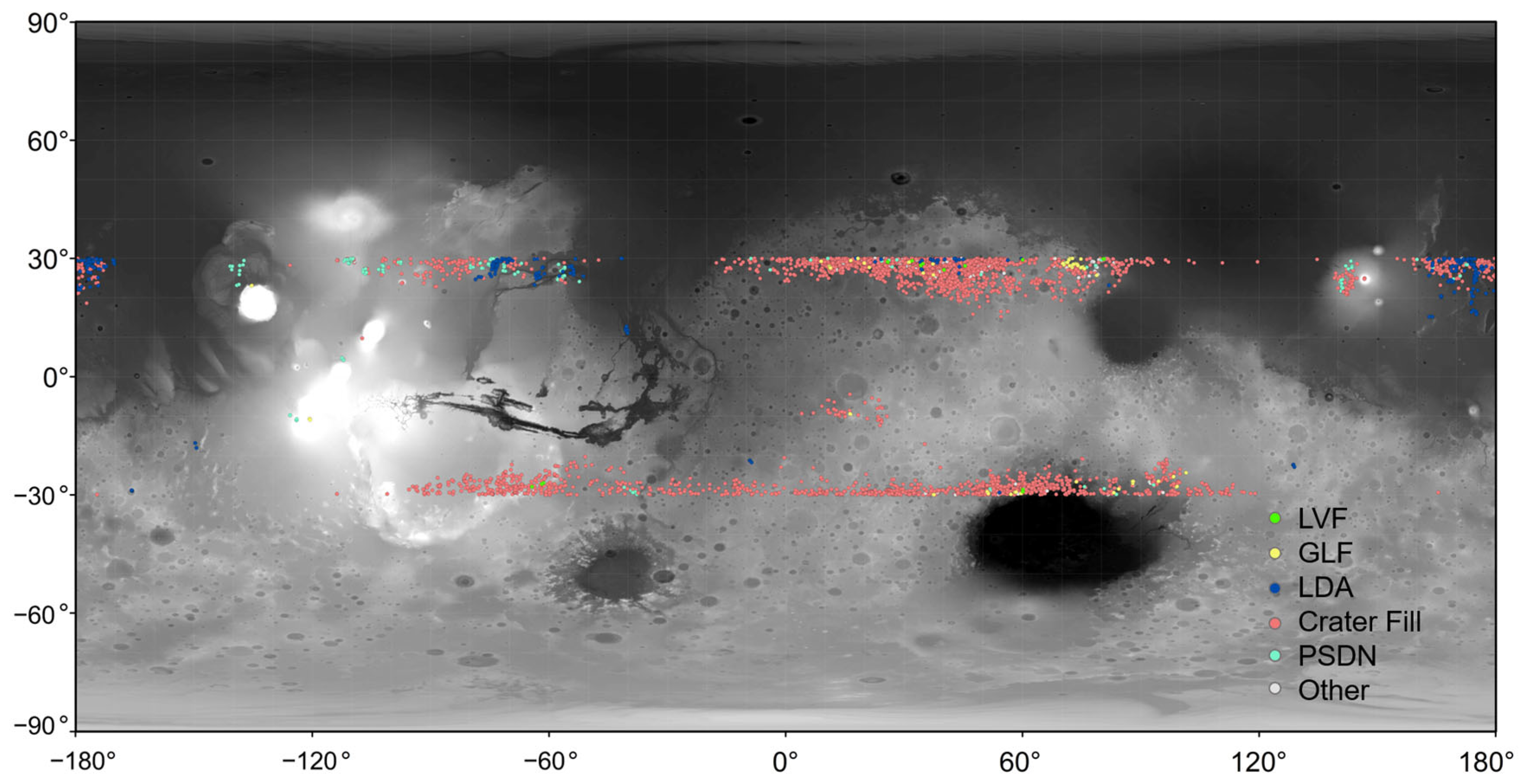
3.1. Characteristics and Global Distribution of Ice-Related Landforms at Low Latitudes

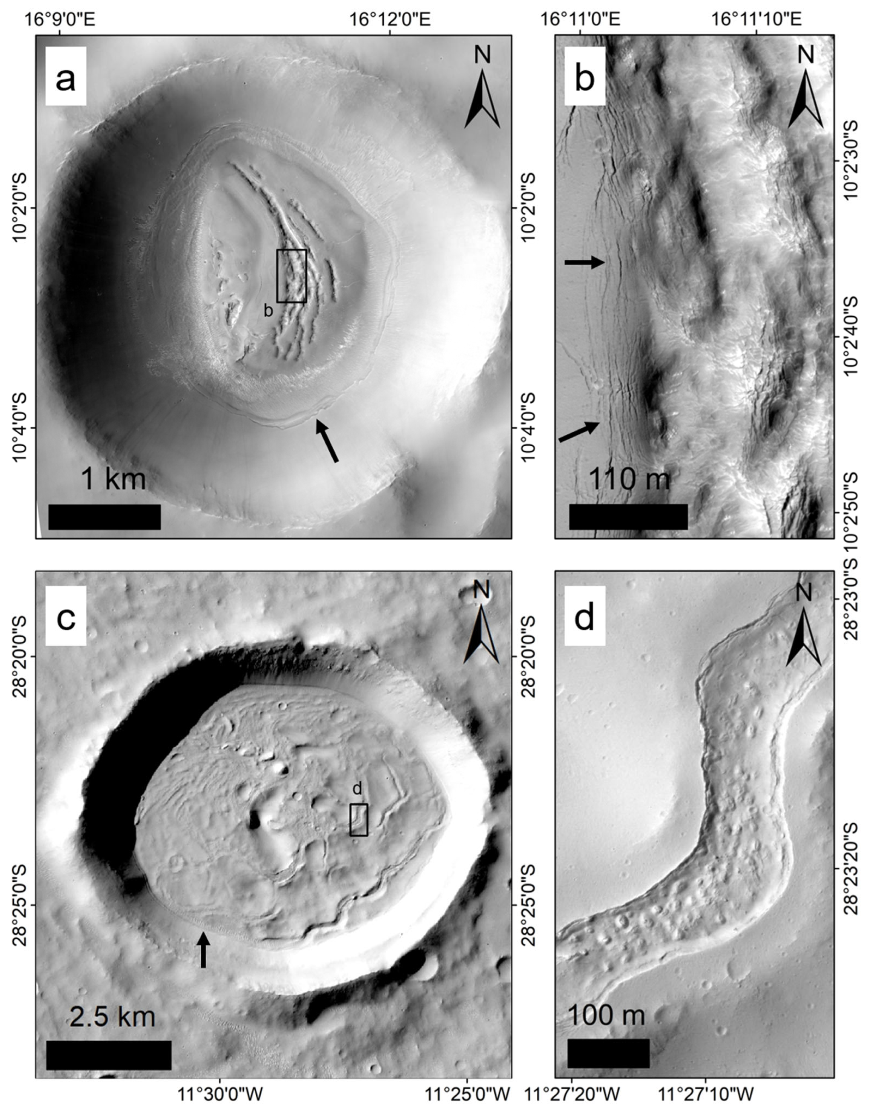
3.1.1. Crater Fill (CF)

Crater fill (CF) features are the most abundant ice-related landforms in the lower latitudes of Mars, accounting for approximately 85% of the 4307 mapped features across the surveyed low-latitude regions of Mars. We classify CFs into four types on the basis of their morphology: concentric crater fill (CCF) (Figure 2), crater irregular fill (Figure 3), crater directional fill (Figure 4), and crater depression (Figure 5).
CCFs at low latitudes resemble those at mid-latitudes, with the crater floors displaying concentric rings or linear structures (Figure 2). The surface features commonly include “brain-terrain” textures [15] and/or RMC morphologies [13] (Figure 2b,d). Crater irregular fills exhibit ice-related textures (Figure 3), often characterized by linear, ice flow-like patterns and pits, which are likely formed by the sublimation of near-surface ice (Figure 3b). In addition, depressions and scarps near the crater floor edges resemble talus deposits, indicative of glacial retreat [6]. Unique features on the crater floors include circular mesas, degraded craters, and RMCs, although linear or “brain-terrain” textures are less common (Figure 3d). Circular mesas are generally considered erosional remnants, potentially shaped by wind or water-related processes, and, in some cases, may also be linked to sublimation-induced collapse in ice-rich terrains. On Earth, these landforms are part of a morphological continuum, akin to terrestrial plateaus, mesas, and buttes, distinguished by their size. RMCs are present on the surface of the deposited material, with cracks observed on the central mesa (Figure 3e), and a network of polygonal cracks is visible on smooth deposited surfaces (Figure 3c,e). Crater directional fills display the occurrence of deposits on the walls of polar-facing craters (Figure 4). For example, Figure 4a shows the directional filling within the interior of a double-layer ejecta rampart crater in Sabaea Terra. Crack networks are distributed across the depositional surface on the crater floor (Figure 4b). Crater depressions are widespread at low latitudes and exhibit a ring of talus, steep scarps parallel to the crater rim, linear depressions composed of pits, and linear cracks (Figure 5, Figure A1 and Figure A2). These materials are thicker near the crater center and thinner toward the rim (Figure A3). Newly observed ice-rich materials are located near 47°E, 15°N (Figure A1e).
CF features are mostly concentrated in Arabia Terra and northern Syrtis Major Planum in the northern hemisphere, as well as around northern Hellas in the southern hemisphere (Figure 6). In the northern hemisphere (15°–30° latitude), the number of CFs increases significantly with the latitude, and the types become more diverse. The CFs are also distributed west of Elysium, northwest of Amazonis Planitia, near Tartarus Colles, and around the northern edge of Hellas, with additional scattered occurrences in the southern highlands near the 30° latitude across longitudes −90° to 90°. Owing to the dichotomy of Martian north–south topography, the mean elevation of the CFs in the northern hemisphere (−1165 m) is significantly lower than that in the southern hemisphere (552 m). In the northern hemisphere, most CFs occur at negative elevations, referring specifically to the height of the deposit surface measured below the Martian datum (0 m), except in areas such as Ceraunius Fossae, parts of Syrtis Major Planum, and Elysium, where the elevations are positive. In the southern hemisphere, CFs near Uzboi Vallis and north of Hellas are generally below 0 m, whereas the CFs in other areas at similar latitudes tend to occur above 0 m, particularly north of Thaumasia, where elevations exceed 1700 m.
The majority of CCFs are concentrated in central Arabia Terra and Tartarus Colles, near the 30°N latitude in the northern hemisphere, and are also locally observed in northern Hellas in the southern hemisphere. Crater irregular fill and crater directional fill are distributed across similar latitudes, with additional occurrences between Uranius Fossae and Labeatis Fossae in the northern hemisphere. In the southern hemisphere, these types of crater fill are found south of Coprates, including eastern Solis Planum, Thaumasia Planum, and parts of Noachis Terra. In contrast, crater depressions are more abundant and geographically widespread than other crater fill types. They typically occur closer to the Martian equator, near 13°N and 19°S. In the northern hemisphere, prominent occurrences are found around Uranius Mons, localized areas of Ceraunius Fossae, the North Kasei Channel, and the Elysium Mons. In the southern hemisphere, crater depressions are most densely clustered between longitudes −95° and 110°, notably within the Sinus Sabaeus region [34]. A distinct spatial transition in crater fill morphology is observed from equatorial to mid-latitude regions, progressing from crater depressions to directional fills, then to irregular fills, and culminating in concentric crater fills at higher latitudes. This pattern may reflect latitudinal variations in climate-related ice deposition and degradation processes.

3.1.2. Lobate Debris Aprons (LDAs)

LDAs, the second largest category, account for approximately 6.6% of the total identified features and are almost exclusively distributed in the northern hemisphere (Figure 7). The morphology of LDAs at low latitudes differs somewhat from that at mid-latitudes, as their formation is constrained by specific geographical environments, possibly indicating distinct formation mechanisms. LDAs are located primarily in northwestern Amazonis Planitia, Kasei Valles, Arabia Terra, and northeastern Elysium Planitia.
In the northeastern Elysium Planitia and northwestern Amazonis Planitia, particularly around Tartarus Colles and Phlegra Dorsa, the surface morphology of LDAs becomes increasingly similar to that of mid-latitude LDAs as they approach the 30°N latitude. These LDAs exhibit an apron-like form, uniformly scattered around mesas or knolls (Figure 7a,b,d). Closer to the equator, the volume and number of LDAs decrease significantly, as shown in Figure 7c. On the western side of Orcus Patera, the apron-like morphology nearly disappears, leaving only the outermost ridge, as indicated by the black arrow in Figure 7e,f.
In Kasei Valles, LDAs exhibit topographic depressions, also known as moats, which encircle mesas or run parallel to hillocks (Figure 7g,h). Hauber et al. [52] interpreted these features as remnants of former LDAs, possibly eroded flood materials, lava flows, or debris flows analogous to volcanic mudflows, which solidified at the front edge of the LDAs. Owing to climate change, these features retreated and formed depressions over time (Figure 7g,h). In Arabia Terra, we identified outwardly parallel ridges on the inner walls of certain craters, extending from the crater rim to the base of the cliffs, and categorized them as LDAs (indicated by black arrows in Figure 7i,j), which is consistent with the classification used in the GIS datasets [11,22].
In the southern hemisphere, LDA-like features are sparse and sporadic, including moat-like structures around hills and ridges at their outermost edges (Figure A4). Possible sublimation lag deposits (Figure A4a,b) occur in the Mangala Valles [53]. In the Peta Crater and nearby craters (Figure A4c), former ice flow or sliding is suggested to have formed ridges [54,55]. This limited distribution may be due to the generally higher elevations of the southern highlands, which reduce the potential for ice accumulation and preservation compared with similar latitudes in the north.

3.1.3. Possible Sublimation Depressions (Non-Crater) (PSDNs)

In addition to crater-associated depressions, we identified depressions outside craters that may have formed due to the sublimation of near-surface ice. The surface of the area is characterized by linear depressions, which are termed “possible sublimation depressions (non-crater)” (PSDNs), based on their morphological features and spatial distribution.
The PSDNs include two subtypes: (1) linear depressions and/or steep scarps, which are typically located within valleys (Figure 8b,d,e,h), and (2) depressions, which exhibit concentric patterns and circular ridges (Figure 8f,g). The latter, as noted by Levy et al. [56], may have resulted from interactions between volcanic activity and subsurface ice. Additionally, staggered and continuous depressions are observed in Lycus Sulci, which are located near hills (Figure 8a). In Ceraunius Fossae, viscous flow material is present within graben floors, with surfaces covered by ice-rich material and ring-mold craters (Figure 8b,c). Valley-associated depressions represent the most common type of PSDNs (Figure 8b,d,e,h). These features are predominantly concentrated in the northern hemisphere, particularly near Lycus Sulci, Ceraunius Fossae, Kasei Valles, and Elysium Mons. In contrast, distinctive concentric depressions with circular ridges are rare, sparsely distributed, and found only in a few isolated locations (Figure 8f,g). No additional morphological subtypes indicative of ice-related processes were identified within the PSDN category, based on the available imagery and mapping resolution.

3.1.4. Glacier-like Form (GLF)

The surface morphology of GLFs at low latitudes is similar to that at mid-latitudes, with textures that flow along topographic gradients (Figure 9). For instance, the boundaries of GLFs are well-defined and terminate in distinct moraine-like ridges (Figure 9a,c,e,i; indicated by the black arrow). In contrast, Figure 9g,h shows less clearly defined boundaries, although the surface textures still exhibit flow patterns, aligned with the topographic gradient.
In the northern hemisphere, GLFs are predominantly distributed at an average latitude of 28.12°. They generally have small volumes and are confined within alcoves strongly influenced by the topography, primarily occurring on north-facing slopes. In the southern hemisphere, GLFs are distributed at an average latitude of 25.12°, tend to have large volumes, and are found mainly on southeast-facing slopes, along the inner or outer walls of craters (Figure 9e,f,I,j). While GLFs are slightly more abundant than LVFs, they remain relatively rare overall.
GLFs are more common in the northern hemisphere than in the southern hemisphere and are sprinkled near Olympus Mons (Figure 9a), where the broad glacial deposits have not yet been fully mapped, although individual GLFs have been identified. They are also observed in central Arabia Terra (Figure 9b) and near the north–south dichotomy of Syrtis Major, possibly indicating multiple glacial events northwest of Nili Fossae (Figure 9c,d). In the southern hemisphere, GLFs are predominantly found around northern Hellas (Figure 9e–j). Examples include moraine-like ridges in the Isil Crater [57,58] (Figure 9e), steep scarps and trim lines formed by glacial sublimation retreat and contraction in the Nako Crater [59] (Figure 9g), and craters on the northwest edge of the Terby Crater [60] (Figure 9h).

3.1.5. Lineated Valley Fills (LVFs)

At low latitudes, the morphology of LVFs resembles that observed in mid-latitude regions, with flow characteristics aligned parallel to the valley walls (Figure 10). However, the linear features on the surface of the LVFs in low-latitude regions are less distinct than those in mid-latitude areas. The occurrence of LVFs at low latitudes is extremely limited, with an average distribution near 28.3° north and south latitudes. LVFs are slightly more prevalent in the northern hemisphere than in the southern hemisphere. In the southern hemisphere, LVFs more clearly exhibit tightly spaced or folded linear features on their surfaces (Figure 10e,g,h). In the northern hemisphere, LVFs are primarily concentrated in Arabia Terra and some valleys to the east, such as the lower reaches of Auqakuh Vallis [61] (Figure 10f). In the southern hemisphere, LVFs are distributed mainly in Thaumasia Planum (Figure 10e,g,h) and the northern part of the Hellas Basin (Figure 10i,j).

3.1.6. Elevation Distribution of Ice-Related Landforms at Low Latitudes

The global mapping results are shown in Figure 11. A total of 4307 features were identified: 3653 crater fills (CFs; 84.82%), 284 LDAs (6.59%), 139 PSDNs (3.23%), 137 other types (3.18%), 79 GLFs (1.83%), and 15 LVFs (0.35%).
We analyzed the elevation distributions of these landforms via MOLA and HRSC blended DEM data, calculated the mean elevation for each 5° longitude interval (Figure A5a) and generated elevation maps for the low-latitude regions (Figure A5b). From 150°E to 225°E (−135°E), the ice-related landforms are mostly confined to the northern hemisphere near −2000 m, with elevations ranging from −4246.81 m to 1529.24 m (average −3061.71 m). From −135°E to −55°E, the average elevation of the ice-related landforms is 1726.58 m, ranging from −3213.14 m to 14,911.33 m. From −55°E to 95°E, the elevation ranges from −6530.90 m to 3082.36 m, with a mean of −824.96 m. From 95°E to 150°W, the elevation ranges from −4631.43 m to 13,624.03 m, with an average of 876.37 m.
Most ice-related landforms occur in regions with negative elevations, such as the eastern Elysium Planitia, western Amazonis Planitia, parts of Kasei Valles, Arabia Terra, and northern Hellas Basin. Ice-related landforms in other areas occur primarily at positive elevations.

3.2. Crater Fills (CFs) in Low-Latitude Regions

3.2.1. Statistical Analysis of the CFs

The slope and aspect measurements are based on a blend of DEM data. The number of CFs is notably greater in the northern hemisphere than in the southern hemisphere (Figure A6a, Figure A7 and Figure A8), with CFs mainly distributed in regions characterized by gentle slopes, based on MOLA–HRSC blended DEM data at a 200 m/pixel resolution (Figure A6b). Furthermore, the majority of fill materials are concentrated in craters less than 20 km in diameter (Figure A6c). The orientation of the CFs is determined by the directionality of the three fill types, other than CCFs. At low latitudes, the orientation of CCFs is less distinct, possibly because of the smaller number of CCFs. Crater irregular fill and crater directional fill are symmetrically distributed across the different hemispheres: the northern hemisphere predominantly features north- and northeast-facing slopes, whereas the southern hemisphere has south- and southeast-facing slopes. On the other hand, crater depressions tend to exhibit fill movement toward the east and southeast, with a surface morphology characterized by depression-dominated crater floors.
The morphological characteristics and slope variations also differ among the fill types. CCFs are typically found in craters 2–15 km in diameter, with slopes not exceeding 4°. Crater irregular fill is observed in craters 2–10 km in diameter, with fill slopes up to 6°. Crater directional fill occurs in craters of all sizes (1–30 km diameter), with slopes ranging from 1° to 13°. Crater depressions are found in relatively flat regions within craters less than 20 km in diameter and with slopes of 12° or less (Figure A7 and Figure A8).

3.2.2. Total Volume of Identified CCFs at Low Latitudes

The volume of the CCF was estimated based on the described calculation method. The total volume of CCF deposits in low-latitude regions was calculated to be approximately 1048.98 km3. To estimate the ice content in these deposits, we considered two hypotheses regarding their origin [22]: glacial ice with 90% ice content [11] and pore ice with 30% ice content [62]. Based on these assumptions, the total ice inventory of low-latitude CCFs was estimated to be 944.08 km3 for glacial ice and 314.69 km3 for pore ice, corresponding to globally equivalent ice thicknesses of 65.1 mm and 21.7 mm, respectively. No error estimations are provided for the estimated volume and ice content in this study, due to inherent limitations in the resolution of the DEM data and uncertainties associated with interpolating the full dataset [22]. As a result, the volume estimate of 30% pore space is a reasonable minimum value for these landforms, following previous studies [22]. This estimate includes only concentric fills within craters, excluding irregular and directional fills. Consequently, the actual ice content in the low-latitude region of Mars is likely even greater than these calculated values.

3.2.3. Age Estimates for the CFs

We analyzed the CSFDs of different crater fill types to estimate their model ages (Table A1). The surveyed area covers approximately 140 km2, within which 291 small craters were identified on the crater fill surface for chronological analysis. The model ages of the CCFs (220 ± 20 Ma, 140 ± 50 Ma) (Figure 12a,b) are broadly consistent with the depositional ages (100 Ma−700 Ma) reported for mid-latitude viscous flow glacial features in previous studies [63,64]. However, the CSFDs of irregularly filled craters reveal variations in the model ages depending on their surface morphologies. Deposits with only RMCs on the surface, lacking any flow patterns (Figure 12c,d), exhibit older model ages in the late Hesperian (~3.4 Ga) and early Amazonian (~2.8 Ga) periods. For an impact crater within the Arabia Terra region (52.49°E, 23.98°N), we analyzed the model ages for the crater directional fill (Figure A9). Although accurately measuring the age of the deposits on the polar-facing interior wall was difficult, only the region on the crater floor was selected for counting, and its modal age (4.2 ± 0.8 Ma) suggests a relatively young depositional period.
However, owing to the limited number and small size of the craters superposed on the deposit surface, the modeled ages should be regarded as approximate estimates. Furthermore, dating results may also be subject to uncertainty due to many other factors. For example, candidate craters that are too small in diameter may lead to biased dating. In addition, the accuracy of diameter identification for some RMCs with heavily degraded boundaries may also affect the results.

4. Discussion

At the global low-latitude scale, ice-related features are primarily found up to 13°N in the northern hemisphere and 19°S in the southern hemisphere. The previously observed restriction of ice indicating features restricted to latitudes above 32°N in the northern hemisphere is no longer consistent, aligning with predicted ice accumulation in the low-latitude Thaumasia region (110°W–60°W) of the southern hemisphere [66]. Levrard et al. [67] predicted that surface water ice accumulation at 40° obliquity would primarily occur near the Tharsis Volcanic Province and the Schiaparelli Basin. In the Tharsis region, water ice is likely deposited on the windward sides of volcanoes under monsoon-like atmospheric circulation [33,68]. In addition, remnant deposition in Sinus Sabaeus most likely occurred due to past obliquity-driven climate change [34].
At low latitudes, ice-related landforms exhibit less pronounced surface textures and are fewer in number and distribution than those at mid-latitudes. This is primarily because current Martian climatic conditions are unfavorable for stable accumulation and long-term preservation of ice-rich materials in low-latitude regions. In addition, intense surface degradation processes, such as aeolian activity or erosion, are more active at lower latitudes and may obscure or erode ice-related features. In many cases, any near-surface ice that may exist is likely buried beneath the regolith layer, thereby limiting its geomorphic expression on the surface. Like the GLFs and LVFs, these features are sporadically distributed in Arabia Terra and Syrtis Major near the dichotomy boundary in the northern hemisphere and in Thaumasia Planum and northern Hellas in the southern hemisphere. LDAs, predominantly located in Tartarus Colles and Kasei Valles, with some occurrences in Arabia Terra, are interpreted as glacial remnants at low latitudes [52]. In contrast, the CFs and PSDNs extend closer to the equator and exhibit broader distributions. Ice-related landforms in the northern hemisphere generally occur at significantly lower elevations than those in the southern hemisphere and are likely influenced by the Mars global dichotomy and atmospheric circulation patterns, which suggests a link between the local topography and favorable conditions for glacial ice accumulation and preservation [69]. A detailed analysis of the CFs revealed that northeast-facing (northern hemisphere) and southeast-facing (southern hemisphere) orientations dominated at low latitudes. This orientation may reflect local climatic and insolation conditions, allowing ice to persist in colder crater regions [5,31,70].
Figure 13 integrates previously published datasets with our results, illustrating the distribution of ice-related landforms on Mars from mid-latitudes to the equator. The two columns on the right of the legend represent prior datasets [8,22,71], which focus primarily on glacial features between 30° and 60° north and south latitudes. Our study extends this mapping into low-latitude regions, addressing a significant data gap. The comparative analysis reveals that our low-latitude results align well with the previous mid-latitude data near 30°N and 30°S, indicating spatial continuity in the landform distribution. Importantly, we introduce newly defined subcategories of ice-related landforms in low-latitude regions. Within the crater fill (CF) category, three subtypes, excluding concentric crater fill (CCF), are newly proposed in this study, based on distinct morphological patterns not previously classified as glacial or periglacial features. In addition, the total number of ice-related landforms mapped at low latitudes in our dataset exceeds that reported in earlier works. These additions provide a more comprehensive and refined characterization of Martian glaciation at low latitudes, enhancing our understanding of the spatial and morphological diversity of ice-related processes beyond the traditionally studied mid-latitude zones. Our results also show uniform coverage across both hemispheres as the dataset extends toward the equator, particularly in regions such as Arabia Terra in the northern hemisphere and northern Hellas in the southern hemisphere, where crater fill features are dominant.
We compared our dataset with the ice consistency maps generated by the SWIM team, which represent the inferred burial depths of subsurface ice, categorized as 1–5 m and >5 m [44]. To facilitate the comparison, we mapped the geomorphological features (a), alongside SWIM-derived data indicating estimated depths to subsurface ice in the range of 1–5 m (b) and >5 m (c) (Figure 14). Good agreement between our dataset and the SWIM results was observed in several key regions. In the northern hemisphere, the key regions include Tartarus Colles (160°–185°E), Uranius Fossae to Tempe Mensa (270°–292°E), and Arabia Terra to Nili Fossae (10°–80°E). In the southern hemisphere, the key regions include the northern Argyre margins (298°–350°E) and northern Hellas margins (39°–100°E). In addition, our findings in the Sinus Sabaeus (3°–15°E) region align well with observations by Shean [34]. Several other blue regions near the equator, some of which are associated with the Medusa Fossae Formation, contain pedestal craters, a landform type not covered by the data in this study. In Figure 14b, the dust layer in certain areas may influence the ground radar signals [40]. We examined several landforms with distinct glacial/periglacial features, using publicly available SHARAD radar data; however, no subsurface reflections were detected. This may be attributed to factors such as steep crater walls or the small, discontinuous nature of the ice-related deposits, which can generate surface clutter that overwhelms the radar signal. Additionally, the absence of reflections may result from the loss of near-surface volatiles or the presence of ice-rich material that is too thin to be detected by SHARAD.
This study suggests that extensive glacial activity occurred in the low-latitude regions of Mars during past periods of high Martian obliquity, potentially preserving substantial subsurface ice within large crater deposits. The crater retention ages of concentric crater fills (CCFs) and other ice-related landforms range from as early as the late Hesperian (~3.4 Ga) to as recent as ~3 Ma, indicating multiple episodes of ice accumulation and reworking. Sinha and Vijayan [5] summarized and compared the geomorphic and topographic characteristics of four typical late Amazonian glacial/periglacial flow features (LVF/LDA, CCF, and VFF), along with their age estimates and obliquity considerations. The flow feature is interpreted to have formed during a period between ~10 and 100 Ma, under obliquity conditions (~30°–45°), similar to those associated with the formation of LDA and LVF landforms [5]. These settings are analogous to the crater directional fill observed in this study, particularly those preserved on pole-facing slopes, suggesting shared climatic control. The wide age range of low-latitude ice-related features may reflect episodic glacial activity linked to successive high-obliquity intervals during the Amazonian period, which is consistent with orbital simulations and stratigraphic correlations across Martian mid- and low-latitudes. However, further constraints, such as regional thermal models and crater degradation analyses, are needed to better resolve the timing, duration, and climatic thresholds of each glaciation episode.
Hauber et al. [52] suggested that LDAs at 25°−30°N formed at approximately 1 Ga, with the current landscapes representing glacial remnants. This aligns with models that predict Martian climatic evolution under relatively high obliquity [20]. Similarly, crater irregular fill features only RMCs on their sediment surfaces, without significant flow patterns, and likely formed during high-obliquity periods, hundreds of millions of years ago. The formation of CCF viscous flow features at low latitudes appears to have aligned temporally with mid-latitude glaciation events, which are estimated to have occurred between 100 Ma and 700 Ma [63,64]. The observed geomorphological features reflect a complex interplay between ice deposition and ice loss through both sublimation and glacial recession. For example, impact crater floor cracks and talus accumulations along crater edges [6] suggest extensive sublimation of near-surface ice. Moreover, the presence of ice-rich debris on crater sidewalls may indicate former glacial activity and downslope transport, indicating transitions between periods of ice accumulation and recession, likely driven by variations in Martian obliquity.
The modal age of polar-facing crater wall deposits (4.2 ± 0.8 Ma) corresponds to relatively recent glaciation during the late Amazonian period, comparable to the CSFDs of small VFFs in Nereidum Montes (2.7 ± 0.8 Ma) [71]. These sediments likely represent the outcomes of recent glacial activity and depositional processes. Our findings are consistent with those of previous analyses, supporting the hypothesis that multiple debris-covered glacial events occurred during the late Amazonian period on Mars. These observations emphasize the dynamic and episodic nature of Martian glaciation, which was driven by climatic changes over geologic timescales. The preservation of young, debris-covered deposits on pole-facing slopes suggests that Martian glaciers may share key similarities with terrestrial rock glaciers. It is likely that past glaciers on Mars contained more extensive clean ice, which progressively transitioned to debris-covered forms through sublimation and surface armoring. While the internal ice content of these flow-like landforms cannot yet be fully explained, their morphology and spatial context strongly indicate past ice activity during their formation and emplacement.
A 3D calculation was performed in regard to the residual glacial landforms (i.e., CCFs in this study) on Mars, with an estimated total volume of 1048.98 km3. Assuming an ice content of 90%, this corresponds to a global ice layer thickness of 65.1 mm; with an ice content of 30%, it corresponds to a global ice layer thickness of 21.7 mm. These estimates are provided as end-member scenarios, assuming ice contents of 90% and 30%, respectively. While the higher end of this range would support an interpretation involving glacial processes, the lower end may indicate debris-dominated rock glaciers or other forms of periglacial activity. However, due to the current lack of direct subsurface ice measurements at these locations, we cannot draw definitive conclusions regarding the dominant process type. The volume of glaciers at low latitudes is much smaller than that of glaciers in mid- to high-latitude areas. Note that we did not estimate the ice volumes of subcategories other than CCFs for several reasons. First, the distributions of GLFs and LVFs are sparse, and their boundaries are often indistinct, making precise definitions challenging. Second, some LDAs are remnants of glacier ice or features resulting from glacial retreat, exhibiting complex characteristics that complicate measurements. Additionally, the sublimation of ice can create depressions and cracks inside or outside craters, further complicating accurate mapping of terrain changes. As only the volume of CCFs was measured, other subcategories were excluded, suggesting that the actual ice content at low latitudes is likely underestimated.

5. Conclusions

In this study, we conducted a detailed visual survey of the entire Martian low-latitude (0°–±30°) region and identified a total of 4307 ice-related landforms in these regions. The identified features include 3653 crater fills (CFs; 84.82%), 284 lobate debris aprons (LDAs; 6.59%), 139 possible sublimation depressions (non-crater) (PSDNs; 3.23%), 79 glacier-like forms (GLFs; 1.83%), and 15 lineated valley fills (LVFs; 0.35%). The remaining 137 features (3.18%) were categorized as “others”, referring to potential ice deposits that may have occurred on plains. The crater fill features were further classified into four subtypes, namely concentric crater fill (CCF), crater irregular fill, crater directional fill, and crater depression. By mapping and analyzing these features, we have expanded the understanding of Martian glacial/periglacial processes, particularly in regions closer to the equator, that were previously underexplored. The key findings are summarized as follows:
  • Ice-related landforms in the lower latitudes of Mars are more extensive than previously thought. The latitudinal extent of ice-related remnants has extended equatorially to 13°N in the northern hemisphere and 19°S in the southern hemisphere, highlighting a broader range for ice-related landforms;
  • The identified ice-related landforms were formed during multiple episodes of Martian geologic history, indicating that Mars has experienced repeated glacial/periglacial processes. These findings support the hypothesis that surface ice extends closer to the equator during periods of high obliquity;
  • Evidence of a dynamic interplay between ice accumulation and ice loss (sublimation) has been observed at low latitudes. These regions had significantly higher ice contents in the past and have since undergone extensive sublimation and removal. Many ice-related remnants have been preserved;
  • Crater fills (CFs) are the most abundant type of ice-related landform at low latitudes, comprising approximately 85% of all the observed features. Among these, irregular fill is the most prevalent subtype. CFs in the northern hemisphere are at lower average elevations (−1165 m) than those in the southern hemisphere (552 m), but their numbers are significantly greater. The elevation contrast between the northern and southern CFs reflects both Martian hemispheric topography and possible differences in climate-driven ice stability. Directional fills are primarily found on the polar-facing walls of craters;
  • The total volume of CCFs at low latitudes on Mars was approximately 1.05 × 10³ km3. Assuming an ice content of 90%, this corresponds to a global equivalent ice layer thickness of 65.1 mm; based on a more conservative assumption of 30% ice content, the equivalent thickness is 21.7 mm. The ice content at low latitudes is likely higher than that suggested by previous studies, necessitating a revised estimate.

Author Contributions

Conceptualization, Y.-Y.S.Z.; investigation, Y.Z.; writing—original draft preparation, Y.Z. and Y.-Y.S.Z.; writing—review and editing, Y.Z., Y.-Y.S.Z., X.X. and Y.W.; visualization, Y.Z.; supervision, Y.-Y.S.Z., X.X. and Y.W.; funding acquisition, Y.-Y.S.Z. All authors have read and agreed to the published version of the manuscript.

Funding

This research was funded by the National Natural Science Foundation of China (Nos. 42441803; 42373042).

Data Availability Statement

All the data generated and analyzed during this study are included in this published article and Appendix A.

Acknowledgments

The authors thank Joseph Levy for his constructive comments and suggestions throughout the project. The authors sincerely thank the four anonymous reviewers for their thorough reviews and constructive comments, which greatly improved the quality and clarity of the manuscript.

Conflicts of Interest

The authors declare that there are no conflicts of interest.

Appendix A

The supporting information includes nine figures (Figure A1, Figure A2, Figure A3, Figure A4, Figure A5, Figure A6, Figure A7, Figure A8 and Figure A9) and one table (Table A1).
Figure A1. Representative examples of crater depressions in the northern hemisphere. The morphology of the features illustrated in (a,c,f,h) is similar to those described by Diot et al. (2015) [41] in Figure 10 and Figure 11, with circular rimless depressions. (a) J22_053229_2052_XN_25N175W; centered at −175.48°E, 25.25°N. (b) G22_026919_2066_XN_26N089W; centered at −90.02°E, 26.39°N. (c) D21_035490_2026_XI_22N088W; centered at −88.59°E, 22.85°N. (d) B01_009957_2030_XI_23N326W; centered at 33.65°E, 23.52°N. (e) Candidate ice-rich materials close to 47°E, 15°N. J01_045138_1954_XN_15N312W; centered at 47.42°E, 15.83°N. (f) N02_063256_1958_XI_15N303W; centered at 56.26°E, 16.54°N. (g) ESP_035261_2005_RED; centered at 43.64°E, 20.10°N. (h) ESP_044914_2000_RED; centered at 41.84°E, 19.73°N.
Remotesensing 17 01939 g0a1
Figure A2. Representative examples of crater depressions in the southern hemisphere. Circular linear textures on the crater floor edges parallel to the crater rims, as well as interspersed linear depressions present in the middle of the crater floor, are widespread at low latitudes. (a) ESP_020019_1700_RED; centered at 13.65°E, −10.04°N. (b) The surface morphology of this material ranges from smooth to dissected, exhibiting a number of pits, cracks, and ridges. These features are similar to those of the candidate ice-rich material within craters mentioned by Shean (2010) [34]. G10_022142_1744_XN_05S349W; centered at 10.93°E, −5.97°N. (c) ESP_024690_1520_RED; centered at −69.09°E, −27.83°N. (d) G23_027089_1558_XN_24S043W; centered at −44.13°E, −23.02°N. (e) U19_078531_1530_XN_27S013W; centered at −12.96°E, −26.31°N. (f) F03_036872_1534_XN_26S011W; centered at −11.47°E, −28.38°N. (g) U14_076562_1524_XN_27S263W; centered at 96.30°E, −26.02°N. (h) F08_039057_1488_XI_31S252W; centered at 107.69°E, −29.94°N.
Remotesensing 17 01939 g0a2
Figure A3. Elevation profiles of four representative types of crater fill based on MOLA shot data. The red dots on the left side of each panel represent different orbital tracks, and the corresponding elevation trend profiles are shown on the right. (a) Crater irregular fill (centered at 39.17°E, 26.28°N). (b) Crater directional fill (centered at 52.49°E, 23.98°N). (c) Crater irregular fill (centered at −31.19°E, −28.51°N). (d) Crater depression (centered at −11.33°E, −28.10°N).
Remotesensing 17 01939 g0a3
Figure A4. Examples of LDA-like characteristics in the southern hemisphere. All images shown are derived from CTX data. (a) LDA-like features in Mangala Valles (P05_002857_1629_XN_17S149W; centered at −149.72°E, −16.72°N). (b) Distinct ridges on the periphery of the pits in Mangala Valles (P05_002857_1629_XN_17S149W; centered at −149.43°E, −17.94°N). (c) Ring ridges in the Peta Crater, as indicated by the black arrows (U09_074601_1587_XI_21S009W; centered at −9.17°E, −21.69°N). (d) Ring of ridges around small hills (P13_006117_1584_XN_21S231W; centered at 128.90°E, −22.96°N).
Remotesensing 17 01939 g0a4
Figure A5. (a) Bar plot illustrating the mean elevation of the studied landforms across each 5° longitude interval. (b) Elevation map displaying all the studied landforms in the low-latitude regions of Mars. Different altitudes are represented by distinct colors, with red indicating higher elevations and blue representing lower elevations.
Remotesensing 17 01939 g0a5
Figure A6. Distributions in terms of elevation with latitude (a), slope (b), and crater diameter (c) for the CFs in the lower-latitude regions of Mars.
Remotesensing 17 01939 g0a6
Figure A7. Quantification of four crater fill subtypes (concentric crater fill, crater directional fill, crater irregular fill, and crater depression) in the low-latitude regions of Mars, categorized by slope (I), aspect (II), and crater diameter (III), for the northern hemisphere. In the aspect plot (II), the horizontal axis indicates the direction of the deposits (e.g., ES represents southeast facing).
Remotesensing 17 01939 g0a7
Figure A8. Quantification of four crater fill subtypes (concentric crater fill, crater directional fill, crater irregular fill, and crater depression) in the low-latitude regions of Mars, categorized by slope (I), aspect (II), and crater diameter (III), for the southern hemisphere. In the aspect plot (II), the horizontal axis indicates the direction of the deposits (e.g., ES represents southeast facing).
Remotesensing 17 01939 g0a8
Figure A9. Age estimates of ice-rich material within the crater directional fill (52.49°E, 23.98°N). (a) Blue contours indicate areas where craters were analyzed, with red outlines marking measured craters. The yellow box highlights the HiRISE detailed image. (b) Crater size-frequency distribution (SFD) for the crater floor depression region. The age estimations in the figures are based on the following references: epoch boundaries from Michael (2013) [65]; production function from Hartmann and Daubar (2016) [51]; and chronology functions from Hartmann (2005) [47] and Michael (2013) [65].
Remotesensing 17 01939 g0a9
Table A1. Summary of crater size–frequency measurements for crater fill landforms.
TypesSpecific ImagesArea SizeNumber of
Craters
Estimated Age
with Errors
Centric crater fillFigure 12a6.47 × 101 km2132220 ± 20 Ma
Crater irregular fill 1Figure 12b3.63 × 101 km26140 ± 50 Ma
Crater irregular fill 2Figure 12c3.81 × 100 km2142.8 + 0.4 Ga/2.8 − 0.7 Ga
Crater irregular fill 3Figure 12d2.62 × 101 km21133.4 + 0.05 Ga/3.4 − 0.07 Ga
Crater directional fillFigure A98.98 × 100 km2264.2 ± 0.8 Ma

References

  1. Carr, M.H. Mars Global Surveyor observations of Martian fretted terrain. J. Geophys. Res. Planets 2001, 106, 23571–23593. [Google Scholar] [CrossRef]
  2. Holt, J.W.; Safaeinili, A.; Plaut, J.J.; Head, J.W.; Phillips, R.J.; Seu, R.; Kempf, S.D.; Choudhary, P.; Young, D.A.; Putzig, N.E. Radar sounding evidence for buried glaciers in the southern mid-latitudes of Mars. Science 2008, 322, 1235–1238. [Google Scholar] [CrossRef]
  3. Sinha, R.K.; Ray, D. Extensive glaciation in the Erebus Montes region of Mars. Icarus 2021, 367, 114557. [Google Scholar] [CrossRef]
  4. Séjourné, A.; Costard, F.; Swirad, Z.M.; Łosiak, A.; Bouley, S.; Smith, I.; Balme, M.R.; Orgel, C.; Ramsdale, J.D.; Hauber, E. Grid mapping the Northern Plains of Mars: Using morphotype and distribution of ice-related landforms to understand multiple ice-rich deposits in Utopia Planitia. J. Geophys. Res. Planets 2019, 124, 483–503. [Google Scholar] [CrossRef]
  5. Sinha, R.K.; Vijayan, S. Geomorphic investigation of craters in Alba Mons, Mars: Implications for Late Amazonian glacial activity in the region. Planet. Space Sci. 2017, 144, 32–48. [Google Scholar] [CrossRef]
  6. Levy, J.S.; Head, J.W.; Marchant, D.R. Lineated valley fill and lobate debris apron stratigraphy in Nilosyrtis Mensae, Mars: Evidence for phases of glacial modification of the dichotomy boundary. J. Geophys. Res. Planets 2007, 112, E08004. [Google Scholar] [CrossRef]
  7. Mangold, N. Geomorphic analysis of lobate debris aprons on Mars at Mars Orbiter Camera scale: Evidence for ice sublimation initiated by fractures. J. Geophys. Res. Planets 2003, 108, 8021. [Google Scholar] [CrossRef]
  8. Souness, C.; Hubbard, B.; Milliken, R.E.; Quincey, D. An inventory and population-scale analysis of martian glacier-like forms. Icarus 2012, 217, 243–255. [Google Scholar] [CrossRef]
  9. Van Gasselt, S.; Hauber, E.; Neukum, G. Lineated valley fill at the Martian dichotomy boundary: Nature and history of degradation. J. Geophys. Res. Planets 2010, 115, E08003. [Google Scholar] [CrossRef]
  10. Baker, D.M.; Head, J.W.; Marchant, D.R. Flow patterns of lobate debris aprons and lineated valley fill north of Ismeniae Fossae, Mars: Evidence for extensive mid-latitude glaciation in the Late Amazonian. Icarus 2010, 207, 186–209. [Google Scholar] [CrossRef]
  11. Head, J.W.; Marchant, D.R.; Dickson, J.L.; Kress, A.M.; Baker, D.M. Northern mid-latitude glaciation in the Late Amazonian period of Mars: Criteria for the recognition of debris-covered glacier and valley glacier landsystem deposits. Earth Planet. Sci. Lett. 2010, 294, 306–320. [Google Scholar] [CrossRef]
  12. Plaut, J.J.; Picardi, G.; Safaeinili, A.; Ivanov, A.B.; Milkovich, S.M.; Cicchetti, A.; Kofman, W.; Mouginot, J.; Farrell, W.M.; Phillips, R.J. Subsurface radar sounding of the south polar layered deposits of Mars. Science 2007, 316, 92–95. [Google Scholar] [CrossRef] [PubMed]
  13. Kress, A.M.; Head, J.W. Ring-mold craters in lineated valley fill and lobate debris aprons on Mars: Evidence for subsurface glacial ice. Geophys. Res. Lett. 2008, 35, L23206. [Google Scholar] [CrossRef]
  14. Pedersen, G.B.M.; Head, J.W. Evidence of widespread degraded Amazonian-aged ice-rich deposits in the transition between Elysium Rise and Utopia Planitia, Mars: Guidelines for the recognition of degraded ice-rich materials. Planet. Space Sci. 2010, 58, 1953–1970. [Google Scholar] [CrossRef]
  15. Levy, J.S.; Head, J.W.; Marchant, D.R. Concentric crater fill in Utopia Planitia: History and interaction between glacial “brain terrain” and periglacial mantle processes. Icarus 2009, 202, 462–476. [Google Scholar] [CrossRef]
  16. Levy, J.; Head, J.; Marchant, D. Thermal contraction crack polygons on Mars: Classification, distribution, and climate implications from HiRISE observations. J. Geophys. Res. Planets 2009, 114, E01007. [Google Scholar] [CrossRef]
  17. Forget, F.; Haberle, R.M.; Montmessin, F.; Levrard, B.; Head, J.W. Formation of glaciers on Mars by atmospheric precipitation at high obliquity. Science 2006, 311, 368–371. [Google Scholar] [CrossRef]
  18. Jakosky, B.M.; Carr, M.H. Possible precipitation of ice at low latitudes of Mars during periods of high obliquity. Nature 1985, 315, 559–561. [Google Scholar] [CrossRef]
  19. Bina, A. The Periglacial Landscape of Mars: Insight into the ‘Decameter-scale Rimmed Depressions’ in Utopia Planitia. Master’s Thesis, The University of Western Ontario, London, ON, Canada, 2018. [Google Scholar]
  20. Laskar, J.; Correia, A.C.; Gastineau, M.; Joutel, F.; Levrard, B.; Robutel, P. Long term evolution and chaotic diffusion of the insolation quantities of Mars. Icarus 2004, 170, 343–364. [Google Scholar] [CrossRef]
  21. Madeleine, J.-B.; Forget, F.; Head, J.W.; Levrard, B.; Montmessin, F.; Millour, E. Amazonian northern mid-latitude glaciation on Mars: A proposed climate scenario. Icarus 2009, 203, 390–405. [Google Scholar] [CrossRef]
  22. Levy, J.S.; Fassett, C.I.; Head, J.W.; Schwartz, C.; Watters, J.L. Sequestered glacial ice contribution to the global Martian water budget: Geometric constraints on the volume of remnant, midlatitude debris-covered glaciers. J. Geophys. Res. Planets 2014, 119, 2188–2196. [Google Scholar] [CrossRef]
  23. Morgan, G.A.; Head III, J.W.; Marchant, D.R. Lineated valley fill (LVF) and lobate debris aprons (LDA) in the Deuteronilus Mensae northern dichotomy boundary region, Mars: Constraints on the extent, age and episodicity of Amazonian glacial events. Icarus 2009, 202, 22–38. [Google Scholar] [CrossRef]
  24. Brough, S.; Hubbard, B.; Hubbard, A. Area and volume of mid-latitude glacier-like forms on Mars. Earth Planet. Sci. Lett. 2019, 507, 10–20. [Google Scholar] [CrossRef]
  25. Hepburn, A.J.; Holt, T.; Hubbard, B.; Ng, F. Creating HiRISE digital elevation models for Mars using the open-source Ames Stereo Pipeline. Geosci. Instrum. Methods Data Syst. 2019, 8, 293–313. [Google Scholar] [CrossRef]
  26. Kadish, S.J.; Head, J.W.; Fastook, J.L.; Marchant, D.R. Middle to Late Amazonian tropical mountain glaciers on Mars: The ages of the Tharsis Montes fan-shaped deposits. Planet. Space Sci. 2014, 91, 52–59. [Google Scholar] [CrossRef]
  27. Shean, D.E.; Head, J.W.; Marchant, D.R. Origin and evolution of a cold-based tropical mountain glacier on Mars: The Pavonis Mons fan-shaped deposit. J. Geophys. Res. Planets 2005, 110, E05001. [Google Scholar] [CrossRef]
  28. Williams, J.M.; Scuderi, L.A.; Newsom, H.E. Numerical Analysis of Putative Rock Glaciers on Mount Sharp, Gale Crater, Mars. Remote Sens. 2022, 14, 1887. [Google Scholar] [CrossRef]
  29. Butcher, F.E.G. Water Ice at Mid-Latitudes on Mars. In Oxford Research Encyclopedia of Planetary Science; Oxford University Press: Oxford, UK, 2022. [Google Scholar]
  30. Chuang, F.C.; Crown, D.A. Surface characteristics and degradational history of debris aprons in the Tempe Terra/Mareotis fossae region of Mars. Icarus 2005, 179, 24–42. [Google Scholar] [CrossRef]
  31. Dickson, J.L.; Head, J.W.; Fassett, C.I. Patterns of accumulation and flow of ice in the mid-latitudes of Mars during the Amazonian. Icarus 2012, 219, 723–732. [Google Scholar] [CrossRef]
  32. Souness, C.; Hubbard, B. Mid-latitude glaciation on Mars. Prog. Phys. Geogr. 2012, 36, 238–261. [Google Scholar] [CrossRef]
  33. Neukum, G.; Jaumann, R.; Hoffmann, H.; Hauber, E.; Head, J.; Basilevsky, A.; Ivanov, B.; Werner, S.; Van Gasselt, S.; Murray, J. Recent and episodic volcanic and glacial activity on Mars revealed by the High Resolution Stereo Camera. Nature 2004, 432, 971–979. [Google Scholar] [CrossRef] [PubMed]
  34. Shean, D.E. Candidate ice-rich material within equatorial craters on Mars. Geophys. Res. Lett. 2010, 37, L24202. [Google Scholar] [CrossRef]
  35. Mitrofanov, I.; Malakhov, A.; Djachkova, M.; Golovin, D.; Litvak, M.; Mokrousov, M.; Sanin, A.; Svedhem, H.; Zelenyi, L. The evidence for unusually high hydrogen abundances in the central part of Valles Marineris on Mars. Icarus 2022, 374, 114805. [Google Scholar] [CrossRef]
  36. Malin, M.C.; Bell, J.F.; Cantor, B.A.; Caplinger, M.A.; Calvin, W.M.; Clancy, R.T.; Edgett, K.S.; Edwards, L.; Haberle, R.M.; James, P.B.; et al. Context Camera Investigation on board the Mars Reconnaissance Orbiter. J. Geophys. Res. Planets 2007, 112, E05S04. [Google Scholar] [CrossRef]
  37. McEwen, A.S.; Ojha, L.; Dundas, C.M.; Mattson, S.S.; Byrne, S.; Wray, J.J.; Cull, S.C.; Murchie, S.L.; Thomas, N.; Gulick, V.C. Seasonal flows on warm Martian slopes. Science 2011, 333, 740–743. [Google Scholar] [CrossRef]
  38. Fergason, R.L.; Hare, T.M.; Laura, J. HRSC and MOLA Blended Digital Elevation Model at 200m v2. Astrogeology PDS Annex, US Geological Survey. 2018. Available online: https://astrogeology.usgs.gov/search?target=&system=&p=1&accscope=&searchBar= (accessed on 19 July 2023).
  39. Smith, D.E.; Zuber, M.T.; Frey, H.V.; Garvin, J.B.; Head, J.W.; Muhleman, D.O.; Pettengill, G.H.; Phillips, R.J.; Solomon, S.C.; Zwally, H.J.; et al. Mars Orbiter Laser Altimeter: Experiment summary after the first year of global mapping of Mars. J. Geophys. Res. Planets 2001, 106, 23689–23722. [Google Scholar] [CrossRef]
  40. Head, J.W.; Nahm, A.L.; Marchant, D.R.; Neukum, G. Modification of the dichotomy boundary on Mars by Amazonian mid-latitude regional glaciation. Geophys. Res. Lett. 2006, 33, L08S03. [Google Scholar] [CrossRef]
  41. Diot, X.; El-Maarry, M.R.; Guallini, L.; Schlunegger, F.; Norton, K.P.; Thomas, N.; Sutton, S.; Grindrod, P.M. An ice-rich flow origin for the banded terrain in the Hellas basin, Mars. J. Geophys. Res. Planets 2015, 120, 2258–2276. [Google Scholar] [CrossRef]
  42. Adeli, S.; Hauber, E.; Kleinhans, M.; Le Deit, L.; Platz, T.; Fawdon, P.; Jaumann, R. Amazonian-aged fluvial system and associated ice-related features in Terra Cimmeria, Mars. Icarus 2016, 277, 286–299. [Google Scholar] [CrossRef]
  43. Robbins, S.J.; Hynek, B.M. A new global database of Mars impact craters ≥1 km: 1. Database creation, properties, and parameters. J. Geophys. Res. Planets 2012, 117, E05004. [Google Scholar] [CrossRef]
  44. Putzig, N.E.; Morgan, G.A.; Sizemore, H.G.; Hollibaugh Baker, D.M.; Petersen, E.I.; Pathare, A.V.; Dundas, C.M.; Bramson, A.M.; Courville, S.W.; Perry, M.R.; et al. Ice Resource Mapping on Mars. In Handbook of Space Resources; Springer: Cham, Switzerland, 2023; pp. 583–616. [Google Scholar]
  45. Garvin, J.; Sakimoto, S.; Frawley, J. Craters on Mars: Global geometric properties from gridded MOLA topography. In Proceedings of the Sixth International Conference on Mars, Pasadena, CA, USA, 20–25 July 2003. [Google Scholar]
  46. Hartmann, W.; Daubar, I. Martian cratering 11. Utilizing decameter scale crater populations to study Martian history. Meteorit. Planet. Sci. 2017, 52, 493–510. [Google Scholar] [CrossRef]
  47. Hartmann, W.K. Martian cratering 8: Isochron refinement and the chronology of Mars. Icarus 2005, 174, 294–320. [Google Scholar] [CrossRef]
  48. Kneissl, T.; van Gasselt, S.; Neukum, G. Map-projection-independent crater size-frequency determination in GIS environments—New software tool for ArcGIS. Planet. Space Sci. 2011, 59, 1243–1254. [Google Scholar] [CrossRef]
  49. Michael, G.; Neukum, G. Planetary surface dating from crater size–frequency distribution measurements: Partial resurfacing events and statistical age uncertainty. Earth Planet. Sci. Lett. 2010, 294, 223–229. [Google Scholar] [CrossRef]
  50. Wang, Y.R.; Zhuo, M.; Zhang, X.R. Automatic Crater Detection Tool for Moon, Mars, and Mercury [DS/OL]; Science Data Bank: Beijing, China, 2024. [Google Scholar]
  51. Hartmann, W.; Daubar, I. Utilizing Small Impact Craters to Clarify the History of Martian Surfaces. In Proceedings of the 79th Annual Meeting of the Meteoritical Society, Berkeley, CA, USA, 27–31 July 2016; p. 6435. [Google Scholar]
  52. Hauber, E.; van Gasselt, S.; Chapman, M.G.; Neukum, G. Geomorphic evidence for former lobate debris aprons at low latitudes on Mars: Indicators of the Martian paleoclimate. J. Geophys. Res. Planets 2008, 113, E02007. [Google Scholar] [CrossRef]
  53. Levy, J.S.; Head, J.W. Evidence for remnants of ancient ice-rich deposits: Mangala Valles outflow channel, Mars. Terra Nova 2005, 17, 503–509. [Google Scholar] [CrossRef]
  54. Guallini, L. Esker-Like Ring-Shaped Ridges in Peta, Novara and Two Other Unnamed Craters on Mars: Evidences of Ancient Glaciers? Space Sci. Rev. 2017, 110, 85–130. [Google Scholar]
  55. Parker, T. Sinuous Ridges in Peta Crater, Mars. In Proceedings of the 42nd Annual Lunar and Planetary Science Conference, The Woodlands, TX, USA, 7–11 March 2011; p. 2776. [Google Scholar]
  56. Levy, J.S.; Goudge, T.A.; Head, J.W.; Fassett, C.I. Candidate volcanic and impact-induced ice depressions on Mars. Icarus 2017, 285, 185–194. [Google Scholar] [CrossRef]
  57. Baliyan, S.; Hayne, P.; Vijayan, S. Isil Crater on Mars: Insights into Volcanic and Glacio-Fluivial Processes. LPI Contrib. 2024, 3007, 3384. [Google Scholar]
  58. Zhang, M.; Zhao, J.; Xiao, L.; Xu, Y.; Bugiolacchi, R.; Wang, J. Fan-shaped deposits in the northern Hellas region, Mars: Implications for the evolution of water reservoir and climate. Icarus 2023, 395, 115470. [Google Scholar] [CrossRef]
  59. Galofre, A.G.; Howard, A.D.; Morgan, A.M.; Wilson, S.A.; Moore, J.M. Glacial sculpting of a martian cratered landscape on the northeastern flank of the Hellas basin. Icarus 2024, 420, 116211. [Google Scholar] [CrossRef]
  60. Wilson, S.A.; Howard, A.D.; Moore, J.M.; Grant, J.A. Geomorphic and stratigraphic analysis of Crater Terby and layered deposits north of Hellas basin, Mars. J. Geophys. Res. Planets 2007, 112, E08009. [Google Scholar] [CrossRef]
  61. Moore, J.M. Nature of the mantling deposit in the heavily cratered terrain of northeastern Arabia, Mars. J. Geophys. Res. Solid Earth 1990, 95, 14279–14289. [Google Scholar] [CrossRef]
  62. Squyres, S.W.; Carr, M.H. Geomorphic evidence for the distribution of ground ice on Mars. Science 1986, 231, 249–252. [Google Scholar] [CrossRef]
  63. Fassett, C.I.; Levy, J.S.; Dickson, J.L.; Head, J.W. An extended period of episodic northern mid-latitude glaciation on Mars during the Middle to Late Amazonian: Implications for long-term obliquity history. Geology 2014, 42, 763–766. [Google Scholar] [CrossRef]
  64. Fastook, J.L.; Head, J.W. Amazonian mid-to high-latitude glaciation on Mars: Supply-limited ice sources, ice accumulation patterns, and concentric crater fill glacial flow and ice sequestration. Planet. Space Sci. 2014, 91, 60–76. [Google Scholar] [CrossRef]
  65. Michael, G. Planetary surface dating from crater size–frequency distribution measurements: Multiple resurfacing episodes and differential isochron fitting. Icarus 2013, 226, 885–890. [Google Scholar] [CrossRef]
  66. Vincendon, M.; Forget, F.; Mustard, J. Water ice at low to midlatitudes on Mars. J. Geophys. Res. Planets 2010, 115, E10001. [Google Scholar] [CrossRef]
  67. Levrard, B.; Forget, F.; Montmessin, F.; Laskar, J. Recent ice-rich deposits formed at high latitudes on Mars by sublimation of unstable equatorial ice during low obliquity. Nature 2004, 431, 1072–1075. [Google Scholar] [CrossRef]
  68. Montmessin, F.; Bertaux, J.-L.; Quémerais, E.; Korablev, O.; Rannou, P.; Forget, F.; Perrier, S.; Fussen, D.; Lebonnois, S.; Rébérac, A. Subvisible CO2 ice clouds detected in the mesosphere of Mars. Icarus 2006, 183, 403–410. [Google Scholar] [CrossRef]
  69. Mischna, M.A.; Richardson, M.I.; Wilson, R.J.; McCleese, D.J. On the orbital forcing of Martian water and CO2 cycles: A general circulation model study with simplified volatile schemes. J. Geophys. Res. Planets 2003, 108, 5062. [Google Scholar] [CrossRef]
  70. Head, J.W.; Mustard, J.F.; Kreslavsky, M.A.; Milliken, R.E.; Marchant, D.R. Recent ice ages on Mars. Nature 2003, 426, 797–802. [Google Scholar] [CrossRef] [PubMed]
  71. Berman, D.C.; Chuang, F.C.; Smith, I.B.; Crown, D.A. Ice-rich landforms of the southern mid-latitudes of Mars: A case study in Nereidum Montes. Icarus 2021, 355, 114170. [Google Scholar] [CrossRef]
Figure 1. (a) Context map of Mars Orbiter Laser Altimeter (MOLA/HRSC) DEM data superimposed on Blendshade. Red represents high elevation, and blue represents low elevation. The map represents the study area of this research (0°–±30°). To more accurately depict the locations of ice-related landforms, the place names of the regions are labeled on the map. (b) Example of concentric crater fill (37.88°N, 75.71°E). (c) Example of lobate debris apron (42.57°N, 17.26°E). (d) Example of a glacier-like form (−38.10°N, 113.12°E). (e) Example of a lineated valley fill (40.42°N, 42.02°E).
Remotesensing 17 01939 g001
Figure 2. Examples of CCFs at low latitudes on Mars, with the images on the right corresponding to the HiRISE magnified image within the box on the left. (a) CCF in Arabia Terra (B16_016062_2119_XI_31N320W; centered at 39.50°E, 29.68°N). (b) “Brain-terrain” texture on the CCF surface (ESP_054843_2100_RED). (c) Concentric filling pattern on the CCF surface (U23_080080_2106_XN_30N187W; centered at 172.47°E, 28.74°N). (d) CCF surfaces characterized by ring-mold craters (RMCs) (ESP_053981_2090_RED).
Remotesensing 17 01939 g002
Figure 3. Examples of crater irregular fill at low latitudes on Mars, with the two images on the right (b,c,e,f) corresponding to the HiRISE magnified image within the box on the left (a,d). (a) The fill material on the floor of this crater flows like icy surface features, and the surface of the overall floor exhibits linear, but nonconcentric, textures similar to CCFs (glacial flow features). Its surface also contains pits that may have been formed by sublimation of near-surface ice, as well as elongated depressions. Additionally, ice-rich material is present on the pole-facing slope of the crater (indicated by the white arrow in (a); J11_049028_2065_XN_26N320W; centered at 39.17°E, 26.28°N). On the floor edge of the crater, a ring of steep talus scarps, parallel to the crater rim, can be observed (black arrow). They are evidence of glacial sublimation and retreat. (b) Characterization of ice flow features on the floor of the crater (ESP_049028_2065_RED). (c) Depositional surface cluttered with polygon-like cracks (ESP_049028_2065_RED). (d) Morphological pattern of the crater irregular fill in Noachis Terra (G06_020535_1510_XI_29S031W; centered at −31.19°E, 28.51°N). The scarps are located on the floor edge of the crater (shown by the black arrow). Crater floors contain circular mesas, fresh bowl craters, ring-mold craters (RMCs), and degraded craters with “oyster shells”, a term referring to distinctive layered, curved surface textures that resemble the overlapping structure of oyster shells [7]. Uniquely, the surfaces of deposited materials rarely have a prominently linear or “brain-terrain” texture. (e) RMCs on the surface of the deposited material, with cracks appearing on the central mesa. Additionally, polygonal cracks are formed around the RMCs (ESP_020535_1510_RED). (f) A heavily degraded crater is visible in the upper part of the panel and is situated on the surface of a crater irregular fill deposit. The black arrows highlight cracks in the central highlands of the RMC and steep talus scarps along the crater walls (ESP_020535_1510_RED). Note that although irregular fills lack the organized tongue-shaped morphology of typical glacier-like forms, their ice flow textures, debris cover, and sublimation-related modifications are broadly consistent with the behavior of rock glaciers on Earth, where ice–debris mixtures undergo slow, ice-supported deformation, similar to those in periglacial settings.
Remotesensing 17 01939 g003
Figure 4. Examples of crater directional fill at low latitudes on Mars, with the two images on the right (b,c,e,f) corresponding to the HiRISE magnified image within the box on the left (a,d). (a) Directional filling of the interior of the double-layer ejecta rampart crater in Sabaea Terra (J04_046285_2044_XN_24N307W; centered at 52.49°E, 23.98°N). The scarps are located on the floor edge of the crater (shown by the white arrow). (b) Crack network on the deposited surface on the floor of the crater (ESP_046285_2045_RED). (c) Deposits on the walls of predominantly poleward-facing craters (ESP_046285_2045_RED). (d) Crater directional fill northwest of Hellas Planitia (ESP_034338_1520_RED; centered at 51.07°E, −27.55°N). (e) A shallow network of cracks on the deposited surface on the floor of the crater (ESP_034338_1520_RED). (f) The black arrows indicate the scarps located on the floor edge of the crater (ESP_034338_1520_RED). The crack networks in (b) are morphologically similar to terrestrial patterned ground commonly found in terrestrial permafrost regions, likely formed by thermal contraction in cold-climate regions.
Remotesensing 17 01939 g004
Figure 5. Examples of crater depression at low latitudes on Mars, with the images on the right corresponding to the HiRISE magnified image within the box on the left. (a) Crater depression in Sabaea Terra, classified as a subtype of crater fill (ESP_020019_1700_RED; centered at 13.65°E, −10.04°N). (b) The pits on the deposited surface have formed linear depressions. Closely spaced linear cracks are observed around the linear depressions (shown by the black arrow). (c) Crater depression at Noachis Terra (ESP_081643_1515_RED; centered at −11.47°E, −28.38°N). (d) Depression on the floor of the crater. The deposited surface around the depression was much smoother (ESP_081643_1515_RED).
Remotesensing 17 01939 g005
Figure 6. Spatial and elevation distribution analysis map of crater fill (CF). (a) Bar plot of the mean elevation of the CF landforms, based on a 5° longitude scale, in the northern hemisphere. Spatial distributions (b) and elevations (c) of various types of CFs in the low-latitude region of Mars. A total of 3653 CFs were mapped globally. (b) A spatial distribution map of 89 CCFs (purple dots; 2.44%), 368 crater directional fills (light blue dots; 10.07%), 1949 crater irregular fills (navy blue dots; 53.35%), and 1247 crater depressions (grass green dots; 34.14%). (c) Elevation distributions: dark red shading represents higher elevations, whereas dark blue shading indicates lower elevations. (d) Bar plot of the mean elevation of the CF landforms, based on a 5° longitude scale, in the southern hemisphere.
Remotesensing 17 01939 g006
Figure 7. Examples of LDAs (lobated debris aprons) at low latitudes on Mars. (a) LDA in northwestern Amazonis Planitia (N09_066021_2094_XN_29N186W; centered at 173.79°E, 29.17°N). (b) Apron-like form uniformly scattered around mesas or knolls in Tartarus Colles (J16_050961_2111_XN_31N175W; centered at −174.77°E, 29.90°N). (c) LDA in northwestern Amazonis Planitia (K04_054785_2049_XN_24N176W; centered at −176.61°E, 26.34°N). (d) The black arrow indicates the position of the LDA (G21_026355_2084_XN_28N172W; centered at −172,71°E, 27.69°N). (e) The LDA sublimated, leaving the outermost ridge on the western side of Orcus Patera (B19_016901_2053_XN_25N185W; centered at 174.77°E, 25.29°N). (f) The most distal ridge of the LDA remnant in the Tartarus Colles region (P22_009925_1977_XN_17N185W; centered at 174.94°E, 16.50°N). (g) The former extent of lobate debris aprons in northern Kasei Valles (P22_009609_1977_XN_17N185W; centered at −73.80°E, 27.79°N). (h) Remnants of former LDAs (D17_033735_2076_XN_27N054W; centered at −54.10°E, 27.54°N). (i) Parallel ridges extending outward from the inner wall of the crater in Arabia Terra (D17_033735_2076_XN_27N054W; centered at 34.67°E, 27.11°N). (j) Parallel ridges extending outward from the inner wall of the crater (J08_048026_2096_XN_29N322W; centered at 37.27°E, 29.34°N).
Remotesensing 17 01939 g007
Figure 8. Typical examples of possible sublimation depressions (non-crater) (PSDNs) at low latitudes. The black arrows indicate the locations of the depressions. (a) Staggered and continuous depressions in the vicinity of the hills in Lycus Sulci (F03_037127_2103_XI_30N141W; centered at −140.68°E, 28.01°N). (b) Very thin ice-rich deposits are present within graben floors in Ceraunius Fossae (K12_057882_2090_XI_29N111W; centered at −110.89°E, 28.93°N). (c) Magnification of the area framed by the black box in the principal panel, showing RMCs on the surface of the VFF. (d) Linear depression and steep scarps at the edge of the valley floor in Nilokeras Fossa (G01_018439_2053_XN_25N057W; centered at −57.42°E, 24.64°N). (e) Linear depressions on the valley graben floor (U16_077035_2041_XN_24N219W; centered at 140.77°E, 21.65°N). (f) Ringed ridges in Kasei Valles (ESP_074115_2090_RED; centered at −66.97°E, 28.71°N). (g) Depression with concentric features (ESP_052297_1515_RED; centered at 80.74°E, −28.40°N). (h) Linear depressions on the valley floor near Kasei Valles (ESP_050351_2085_RED; centered at −79.74°E, 28.06°N).
Remotesensing 17 01939 g008
Figure 9. Examples of GLFs (glacier-like forms) at low latitudes on Mars. The black arrows indicate the terminals of the GLF. (a) GLF in Olympus Mons (B17_016464_2034_XI_23N135W; −135.35°E, 23.06°N). (b) N08_065472_2047_XN_24N322W; 37.41°E, 25.80°N. (c) Evidence of possible multiple glacial events northwest of Nili Fossae (D21_035550_2073_XI_27N284W; centered at 75.27°E, 27.83°N). (d) GLF in the Nilosyrtis region (ESP_055132_2090_RED; centered at 70.31°E, 28.65°N). (e) GLF within the Isil Crater (D17_033730_1526_XI_27S272W; centered at 87.85°E, −26.61°N). (f) GLFs on the outer wall of a crater in the southern hemisphere (G16_024448_1519_XN_28S301W; centered at 58.24°E, −29.27°N). (g) GLF within the Nako Crater (D18_034139_1509_XN_29S277W; centered at 83.17°E, −29.42°N). (h) GLF in a crater on the northwest edge of the Terby Crater (D14_032557_1531_XI_26S286W; centered at 73.63°E, −26.69°N). (i) Example of GLFs (D15_033255_1551_XI_24S265W; centered at 94.53°E, −26.52°N). (j) The black arrows point to the moraine-like ridges of the GLF (P18_008109_1536_XI_26S261W; centered at 98.31°E, −25.47°N).
Remotesensing 17 01939 g009
Figure 10. Examples of LVFs at low latitudes on Mars. (e,gj) LVFs in the southern hemisphere with larger deposition volumes and more pronounced linear features on their surfaces than those in the northern hemisphere (ad,f). (a) Example of LVF in the northern hemisphere (P18_007940_2082_XI_28N334W; centered at 25.87°E, 29.03°N). (b) Magnified HiRISE view of the area within the black box in (a). A possible sublimation-induced linear depression is present at the terminal end of the LVF (ESP_052114_2095_RED; centered at 25.83°E, 29.16°N). (c) Example of LVF in the northern hemisphere (N10_066171_2068_XN_26N319W; centered at 40.17°E, 27.10°N). (d) LVF in Arabia Terra (B16_016075_2091_XN_29N314W; centered at 45.33°E, 28.00°N). (e) Linear features characterize the LVF in Thaumasia Planum (J07_047674_1519_XN_28S064W; centered at −64.27°E, −27.90°N). (f) Channel at the bottom of Auqakuh Vallis showing remnants interpreted as lobate debris flow (LVF) deposits (P08_003970_2091_XI_29N299W; centered at 60.18°E, 29.90°N). While a fluvial origin (e.g., terrace formation) cannot be ruled out, the morphology and regional context favor a glacial interpretation. (g) Linear features characterize the LVF in Thaumasia Planum (B02_010620_1529_XI_27S061W; centered at −61.41°E, −26.96°N). (h) Linear features characterize the LVF in the southern hemisphere (G11_022659_1527_XN_27S061W; centered at −61.82°E, −27.23°N). (i) ESP_030461_1505_RED; centered at 60.10°E, −29.17°N. (j) ESP_016378_1510_RED; centered at 60.12°E, −28.65°N.
Remotesensing 17 01939 g010
Figure 11. Spatial distribution of ice-related landforms in the low-latitude regions of Mars identified in this study. The legend indicates the color corresponding to each landform type. The base map is a 10° × 10° grid, based on the MOLA dataset.
Remotesensing 17 01939 g011
Figure 12. Age estimation of ice-rich material in impact craters. The blue outline indicates regions where impact craters were counted, whereas the red outline marks the measured craters. (a) Centered at 172.47°E, 28.74°N; (b) centered at 89.03°E, 29.39°N; (c) centered at −30.99°E, −29.27°N; and (d) centered at −31.19°E, −28.51°N. The age estimations in the figures are based on the following references: epoch boundaries from Michael (2013) [65]; production function from Hartmann and Daubar (2016) [51]; and chronology functions from Hartmann (2005) [47] and Michael (2013) [65].
Remotesensing 17 01939 g012
Figure 13. Integration with previously published datasets reveals ice-related landforms extending from the mid-latitudes to the equator on Mars. Figure legends for LVF, GLF, LDA, crater fill, PSDN, and other represent data from this study for low-latitude regions (±30°), whereas LVF-M, GLF-M, LDA-M, CCF-M, and VFFs-M represent previously published data for mid-latitude regions. Data sources for mid-latitudes: GLF-M [8]; LVF-M, LDA-M, CCF-M [22]; VFFs-M [71].
Remotesensing 17 01939 g013
Figure 14. Integrated ice consistency maps, published by the SWIM team, with our data, including geomorphology (a) and subsurface ice depth categories of 1–5 m (b) and >5 m (c), representing the inferred burial depth of ground ice. The darker the blue color is, the strong the glacial/periglacial signal. Data sources: pink dots (data from this study); blue dots (ground ice distribution from the SWIM team) [44].
Remotesensing 17 01939 g014
Disclaimer/Publisher’s Note: The statements, opinions and data contained in all publications are solely those of the individual author(s) and contributor(s) and not of MDPI and/or the editor(s). MDPI and/or the editor(s) disclaim responsibility for any injury to people or property resulting from any ideas, methods, instructions or products referred to in the content.

