

Mapping Ecosystem Functional Groups in the Republic of Korea Based on the IUCN Global Ecosystem Typology


Abstract
:1. Introduction
2. Materials and Methods
2.1. Study Area
2.2. Data Acquisition and EFG Map Development
2.3. Landsat 8–9 Satellite Imagry
2.4. Random Forest Modeling
3. Results
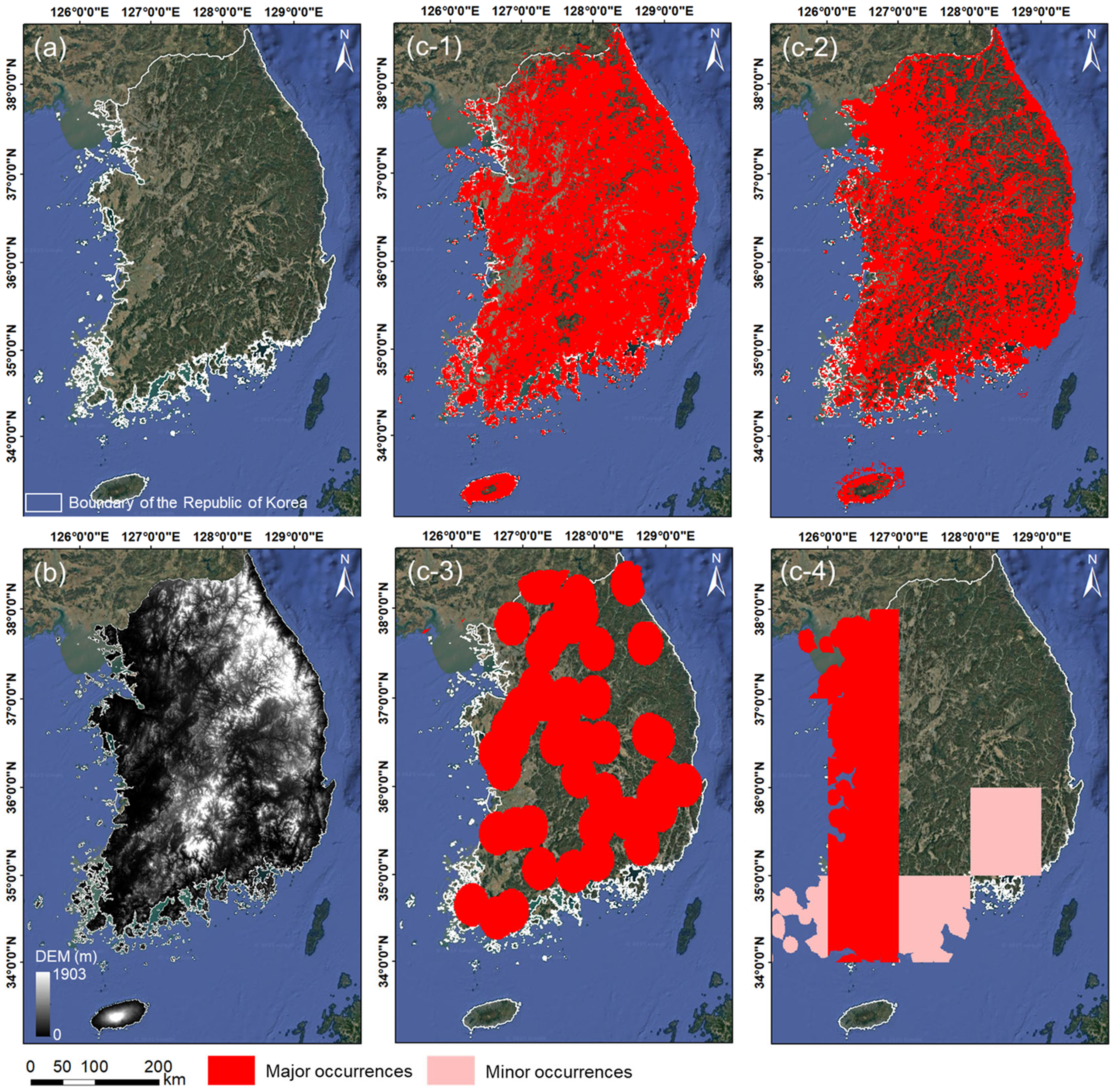
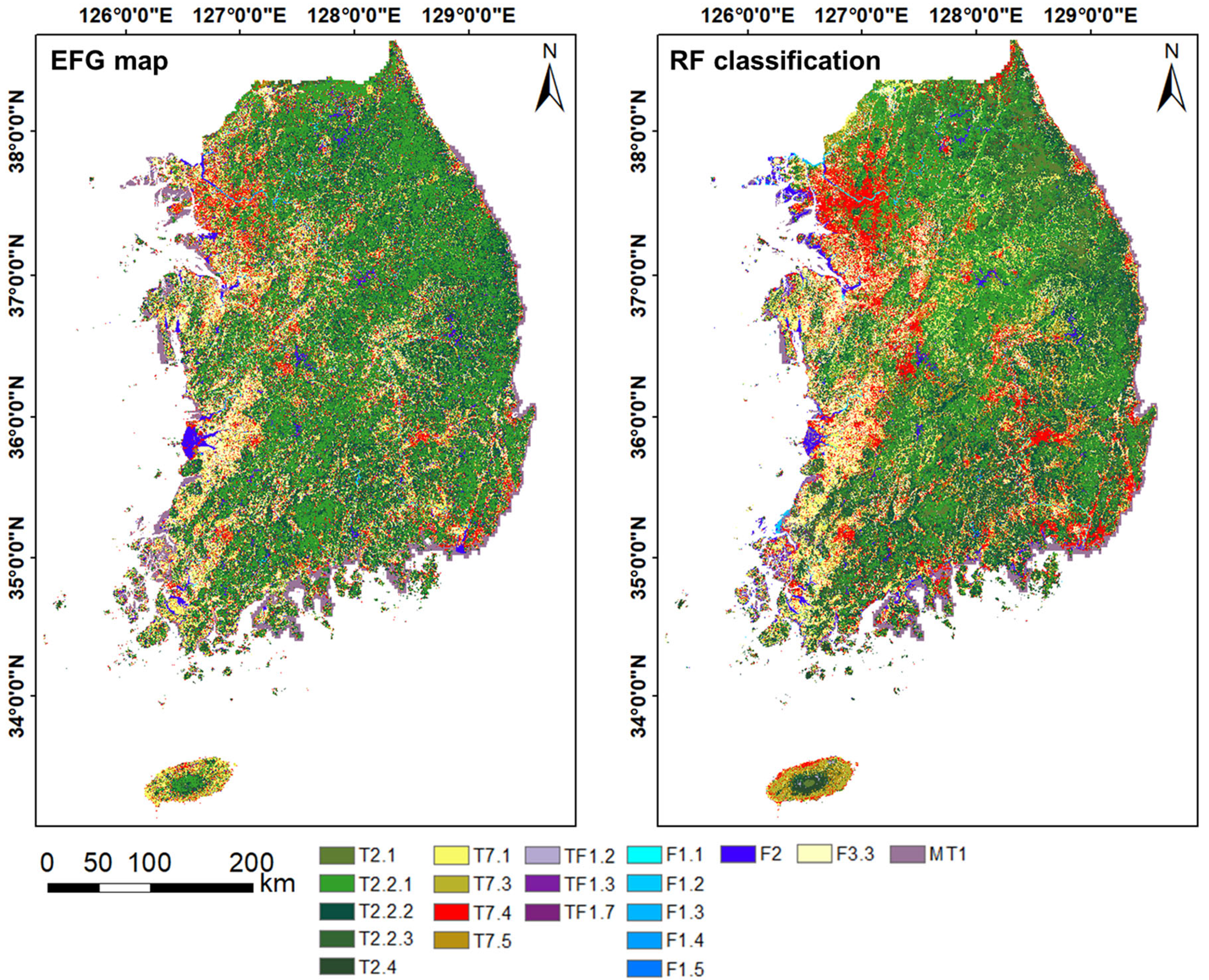
3.1. Result of EFG Map Development for the Republic of Korea
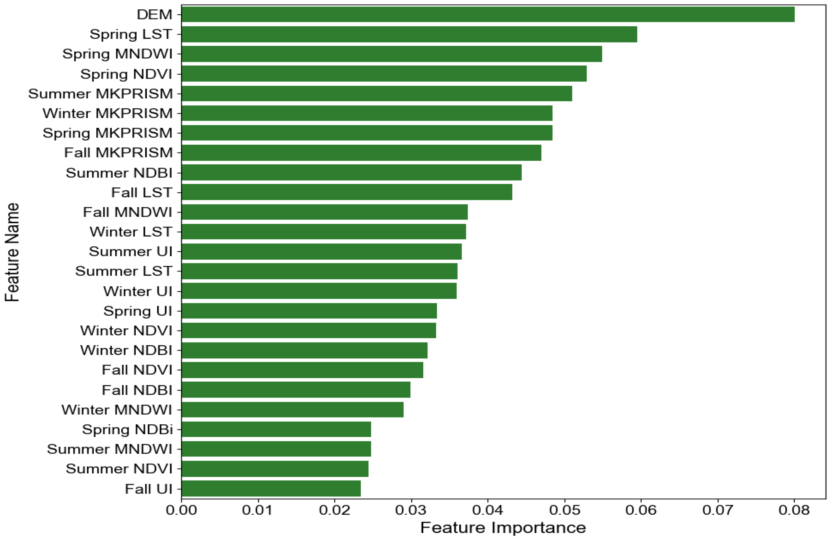
3.2. Classification Results
3.3. Mapping Results
4. Discussion
4.1. Integration of National Data with the IUCN GET Framework
4.2. Key Predictors and Ecological Relevance
4.3. Limitations and Future Work
5. Conclusions
Author Contributions
Funding
Data Availability Statement
Conflicts of Interest
Appendix A

| Major Class | Code | Subdivision Class | Criteria |
|---|---|---|---|
| Used Area | 111 | Detached Residential Area | Areas primarily consisting of single-family houses, excluding apartments, villas, and row houses |
| 112 | Multi-family Residential Area | Areas dominated by apartments, villas, and row houses | |
| 121 | Industrial Facility | Areas designated for manufacturing and processing industries | |
| 131 | Commercial Facility | Areas for retail, wholesale, offices, and services | |
| 132 | Mixed-use Area | Areas where residential, commercial, and industrial facilities coexist | |
| 141 | Cultural, Sports, and Recreational Facilities | Areas designated for cultural, sports, and recreational activities | |
| 151 | Airport | Facilities for air transportation, including runways, terminals, and hangars | |
| 152 | Port | Facilities for maritime transportation, including docks, warehouses, and breakwaters | |
| 153 | Railway | Rail tracks and associated facilities like stations and maintenance areas | |
| 154 | Road | Paved roads and bridges, including highways and local roads | |
| 155 | Other Transportation and Communication Facility | Facilities not classified under other transportation categories, such as helipads and broadcasting stations | |
| 161 | Environmental Infrastructure Facility | Facilities for environmental protection and waste management, including treatment plants and recycling centers | |
| 162 | Educational and Administrative Facility | Schools, universities, government offices, and related facilities | |
| 163 | Other Public Facility | Public facilities not classified elsewhere, such as religious sites, correctional facilities, and military bases | |
| Agricultural Areas | 211 | Paddy Field (Leveled) | Leveled fields used for rice cultivation |
| 212 | Paddy Field (Unleveled) | Unleveled fields used for rice cultivation | |
| 221 | Upland Field (Leveled) | Leveled fields used for cultivating crops other than rice | |
| 222 | Upland Field (Unleveled) | Unleveled fields used for cultivating crops other than rice | |
| 231 | Facility Cultivation Area | Areas with greenhouses or other structures for plant cultivation | |
| 241 | Orchard | Areas planted with fruit-bearing trees | |
| 251 | Ranch and Aquaculture Area | Areas used for livestock grazing and aquaculture activities | |
| 252 | Other Cultivated Area | Areas used for horticulture, landscaping, and nurseries | |
| Forest | 311 | Deciduous Forest | Forests dominated by deciduous trees |
| 321 | Coniferous Forest | Forests dominated by coniferous trees | |
| 331 | Mixed Forest | Forests with a mix of deciduous and coniferous trees | |
| Grass | 411 | Natural Grassland | Naturally occurring grass-covered areas |
| 421 | Golf Course | Areas designated for golf, including fairways and greens | |
| 422 | Cemetery | Areas designated for burial purposes | |
| 423 | Other Grassland | Grass-covered areas not classified elsewhere, including buffer zones and slopes | |
| Wet Land | 511 | Inland Wetland | Areas with saturated soil conditions, including marshes and swamps |
| 521 | Mudflat | Coastal wetlands exposed during low tide | |
| 522 | Salt Pan | Areas used for salt production through evaporation | |
| Barren | 611 | Beach | Sandy or pebbly shorelines along bodies of water |
| 612 | Riverbank | Areas adjacent to rivers, often with exposed soil or vegetation | |
| 613 | Cliff and Rock | Areas with exposed rock formations or steep slopes | |
| 621 | Mining Area | Areas where mineral extraction activities occur | |
| 622 | Sports Ground | Open areas designated for sports activities, typically with bare soil | |
| 623 | Other Bare Land | Areas with little to no vegetation, including construction sites and cleared lands | |
| Water | 711 | River | Natural flowing watercourses |
| 712 | Lake | Inland bodies of standing water, including reservoirs | |
| 721 | Ocean Water | Marine areas beyond the coastline |

References
- Matias, M.G.; Combe, M.; Barbera, C.; Mouquet, N. Ecological strategies shape the insurance potential of biodiversity. Front. Microbiol. 2013, 3, 432. [Google Scholar] [CrossRef] [PubMed]
- Parks, L.; Tsioumani, E. Transforming biodiversity governance? Indigenous peoples’ contributions to the Convention on Biological Diversity. Biol. Conserv. 2023, 280, 109933. [Google Scholar] [CrossRef]
- Hák, T.; Janoušková, S.; Moldan, B. Sustainable Development Goals: A need for relevant indicators. Ecol. Indic. 2016, 60, 565–573. [Google Scholar] [CrossRef]
- Yao, Y.; Zhang, D.; Nan, Y.; Jin, S.; Sun, Y. Environmental degradation in the Korean Peninsula: Evidence from the environmental degradation index. Ecol. Indic. 2024, 158, 111503. [Google Scholar] [CrossRef]
- Hansen, A.J.; Noble, B.P.; Veneros, J.; East, A.; Goetz, S.J.; Supples, C.; Watson, J.E.M.; Jantz, P.A.; Pillay, R.; Jetz, W.; et al. Toward monitoring forest ecosystem integrity within the post-2020 Global Biodiversity Framework. Conserv. Lett. 2021, 14, e12822. [Google Scholar] [CrossRef]
- Bland, L.M.; Nicholson, E.; Miller, R.M.; Andrade, A.; Carré, A.; Etter, A.; Ferrer-Paris, J.R.; Herrera, B.; Kontula, T.; Lindgaard, A.; et al. Impacts of the IUCN Red List of Ecosystems on conservation policy and practice. Conserv. Lett. 2019, 12, e12666. [Google Scholar] [CrossRef]
- Rodríguez, J.P.; Keith, D.A.; Rodríguez-Clark, K.M.; Murray, N.J.; Nicholson, E.; Regan, T.J.; Miller, R.M.; Barrow, E.G.; Bland, L.M.; Boe, K.; et al. A practical guide to the application of the IUCN Red List of Ecosystems criteria. Philos. Trans. R. Soc. B Biol. Sci. 2015, 370, 20140003. [Google Scholar] [CrossRef]
- Andreatta, D.; Gianelle, D.; Scotton, M.; Dalponte, M. Estimating grassland vegetation cover with remote sensing: A comparison between Landsat-8, Sentinel-2 and PlanetScope imagery. Ecol. Indic. 2022, 141, 109102. [Google Scholar] [CrossRef]
- Capotorti, G.; Del Vico, E.; Copiz, R.; Facioni, L.; Zavattero, L.; Bonacquisti, S.; Paolanti, M.; Blasi, C. Ecosystems of Italy. Updated mapping and typology for the implementation of national and international biodiversity-related policies. Plant Biosyst. 2023, 157, 1248–1258. [Google Scholar] [CrossRef]
- García-Pardo, K.A.; Moreno-Rangel, D.; Domínguez-Amarillo, S.; García-Chávez, J.R. Remote sensing for the assessment of ecosystem services provided by urban vegetation: A review of the methods applied. Urban For. Urban Green. 2022, 74, 127636. [Google Scholar] [CrossRef]
- Murray, N.J.; Keith, D.A.; Bland, L.M.; Ferrari, R.; Lyons, M.B.; Lucas, R.; Pettorelli, N.; Nicholson, E. The role of satellite remote sensing in structured ecosystem risk assessments. Sci. Total Environ. 2018, 619, 249–257. [Google Scholar] [CrossRef] [PubMed]
- Grabska, E.; Frantz, D.; Ostapowicz, K. Evaluation of machine learning algorithms for forest stand species mapping using Sentinel-2 imagery and environmental data in the Polish Carpathians. Remote Sens. Environ. 2020, 251, 112103. [Google Scholar] [CrossRef]
- Hemmerling, J.; Pflugmacher, D.; Hostert, P. Mapping temperate forest tree species using dense Sentinel-2 time series. Remote Sens. Environ. 2021, 267, 112743. [Google Scholar] [CrossRef]
- James, K.; Bradshaw, K. Detecting plant species in the field with deep learning and drone technology. Methods Ecol. Evol. 2020, 11, 1509–1519. [Google Scholar] [CrossRef]
- Melichar, M.; Didan, K.; Barreto-Muñoz, A.; Duberstein, J.N.; Jiménez Hernández, E.; Crimmins, T.; Li, H.; Traphagen, M.; Thomas, K.A.; Nagler, P.L. Random forest classification of multitemporal Landsat 8 spectral data and phenology metrics for land cover mapping in the Sonoran and Mojave deserts. Remote Sens. 2023, 15, 1266. [Google Scholar] [CrossRef]
- Pizarro, S.E.; Pricope, N.G.; Vargas-Machuca, D.; Huanca, O.; Ñaupari, J. Mapping land cover types for highland Andean ecosystems in Peru using google earth engine. Remote Sens. 2022, 14, 1562. [Google Scholar] [CrossRef]
- Keith, D.A.; Ferrer-Paris, J.R.; Nicholson, E.; Bishop, M.J.; Polidoro, B.A.; Ramirez-Llodra, E.; Tozer, M.G.; Nel, J.L.; Mac Nally, R.; Gregr, E.J.; et al. A function-based typology for Earth’s ecosystems. Nature 2022, 610, 513–518. [Google Scholar] [CrossRef]
- Keith, D.A.; Ferrer-Paris, J.R.; Nicholson, E.; Kingsford, R.T. IUCN Global Ecosystem Typology 2.0: Descriptive Profiles for Biomes and Ecosystem Functional Groups; IUCN: Gland, Switzerland, 2020. [Google Scholar] [CrossRef]
- Keith, D.A.; Ferrer-Paris, J.R.; Ghoraba, S.M.M.; Henriksen, S.; Monyeki, M.; Murray, N.J.; Nicholson, E.; Rowland, J.; Skowno, A.; Slingsby, J.A.; et al. Guidelines for the Application of IUCN Red List of Ecosystems Categories and Criteria: Version 2.0; IUCN: Gland, Switzerland, 2024. [Google Scholar] [CrossRef]
- Sohn, H.J.; Won, S.Y.; Jeon, J.E.; Park, E.H.; Kim, D.H.; Han, S.H.; Song, Y.K. A study on the application of IUCN Global Ecosystem Typology using land cover map in Korea. Korean J. Environ. Ecol. 2023, 37, 209–220. [Google Scholar] [CrossRef]
- Hong, M.; Song, C.; Kim, M.; Kraxner, F.; Ko, Y.; Son, J.; Lee, W.K. Realizing climate resilient development pathways in forestry: A focus on carbon management in Republic of Korea. Environ. Impact Assess. Rev. 2025, 110, 107665. [Google Scholar] [CrossRef]
- Lee, K.; Sung, H.C.; Seo, J.Y.; Yoo, Y.; Kim, Y.; Kook, J.H.; Jeon, S.W. The integration of remote sensing and field surveys to detect ecologically damaged areas for restoration in South Korea. Remote Sens. 2020, 12, 3687. [Google Scholar] [CrossRef]
- Kim, T.S.; Dhakal, T.; Kim, S.H.; Lee, J.H.; Kim, S.J.; Jang, G.S. Examining village characteristics for forest management using self-and geographic self-organizing maps: A case from the Baekdudaegan mountain range network in Korea. Ecol. Indic. 2023, 148, 110070. [Google Scholar] [CrossRef]
- Seong, S.; Chang, A.; Mo, J.; Na, S.; Ahn, H.; Oh, J.; Choi, J. Crop classification in South Korea for multitemporal PlanetScope imagery using SFC-DenseNet-AM. Int. J. Appl. Earth Obs. Geoinf. 2024, 126, 103619. [Google Scholar] [CrossRef]
- Park, M. Analysis of the characteristics and evaluation of ecological functions of local wetlands distributed in Chungcheongnam-do, Rep. of Korea. Ecol. Eng. 2024, 208, 107381. [Google Scholar] [CrossRef]
- Pekel, J.F.; Cottam, A.; Gorelick, N.; Belward, A.S. High-resolution mapping of global surface water and its long-term changes. Nature 2016, 540, 418–422. [Google Scholar] [CrossRef]
- Lehner, B.; Grill, G. Global river hydrography and network routing: Baseline data and new approaches to study the world’s large river systems. Hydrol. Process. 2013, 27, 2171–2186. [Google Scholar] [CrossRef]
- Park, J.; Jang, D.H. Application of MK-PRISM for interpolation of wind speed and comparison with co-kriging in South Korea. GISci. Remote Sens. 2016, 53, 421–443. [Google Scholar] [CrossRef]
- Kim, B.H.; Kim, Y.O.; Kam, J. Hyper-resolution naturalized streamflow data for Geum River in South Korea (1951–2020). Sci. Data 2025, 12, 210. [Google Scholar] [CrossRef]
- Berra, E.F.; Fontana, D.C.; Yin, F.; Breunig, F.M. Harmonized Landsat and Sentinel-2 Data with Google Earth Engine. Remote Sens. 2024, 16, 2695. [Google Scholar] [CrossRef]
- Dong, P.; Gao, L.; Zhan, W.; Liu, Z.; Li, J.; Lai, J.; Li, H.; Huang, F.; Tamang, S.K.; Zhao, L. Global comparison of diverse scaling factors and regression models for downscaling Landsat-8 thermal data. ISPRS J. Photogramm. Remote Sens. 2020, 169, 44–56. [Google Scholar] [CrossRef]
- Zheng, Y.; Tang, L.; Wang, H. An improved approach for monitoring urban built-up areas by combining NPP-VIIRS nighttime light, NDVI, NDWI, and NDBI. J. Clean. Prod. 2021, 328, 129488. [Google Scholar] [CrossRef]
- Lee, K.; Kim, B.; Park, S. Evaluating the potential of burn severity mapping and transferability of Copernicus EMS data using Sentinel-2 imagery and machine learning approaches. GISci. Remote Sens. 2023, 60, 2192157. [Google Scholar] [CrossRef]
- Obata, S.; Cieszewski, C.J.; Lowe, R.C., III; Bettinger, P. Random forest regression model for estimation of the growing stock volumes in Georgia, USA, using dense Landsat time series and FIA dataset. Remote Sens. 2021, 13, 218. [Google Scholar] [CrossRef]
- Pande, C.B.; Srivastava, A.; Moharir, K.N.; Radwan, N.; Mohd Sidek, L.; Alshehri, F.; Pal, S.C.; Tolche, A.D.; Zhran, M. Characterizing land use/land cover change dynamics by an enhanced random forest machine learning model: A Google Earth Engine implementation. Environ. Sci. Eur. 2024, 36, 84. [Google Scholar] [CrossRef]
- Pham, Q.B.; Ali, S.A.; Parvin, F.; Van On, V.; Sidek, L.M.; Đurin, B.; Cetl, V.; Šamanović, S.; Minh, N.N. Multi-spectral remote sensing and GIS-based analysis for decadal land use land cover changes and future prediction using random forest tree and artificial neural network. Adv. Space Res. 2024, 74, 17–47. [Google Scholar] [CrossRef]
- Breiman, L. Random forests. Mach. Learn. 2001, 45, 5–32. [Google Scholar] [CrossRef]
- Archer, K.J.; Kimes, R.V. Empirical characterization of random forest variable importance measures. Comput. Stat. Data Anal. 2008, 52, 2249–2260. [Google Scholar] [CrossRef]
- Benkendorf, D.J.; Hawkins, C.P. Effects of sample size and network depth on a deep learning approach to species distribution modeling. Ecol. Inform. 2020, 60, 101137. [Google Scholar] [CrossRef]
- Taufik, A.; Ahmad, S.S.S. Land cover classification of Landsat 8 satellite data based on Fuzzy Logic approach. IOP Conf. Ser. Earth Environ. Sci. 2016, 37, 012062. [Google Scholar] [CrossRef]
- Avtar, R.; Kouser, A.; Kumar, A.; Singh, D.; Misra, P.; Gupta, A.; Yunus, A.P.; Kumar, P.; Johnson, B.A.; Dasgupta, R.; et al. Remote sensing for international peace and security: Its role and implications. Remote Sens. 2021, 13, 439. [Google Scholar] [CrossRef]
- Szantoi, Z.; Geller, G.N.; Tsendbazar, N.E.; See, L.; Griffiths, P.; Fritz, S.; Gong, P.; Herold, M.; Mora, B.; Obregón, A. Addressing the need for improved land cover map products for policy support. Environ. Sci. Policy 2020, 112, 28–35. [Google Scholar] [CrossRef]
- Ibrahim, S.A.; Balzter, H.; Tansey, K. Machine learning feature importance selection for predicting aboveground biomass in African savannah with Landsat 8 and ALOS PALSAR data. Mach. Learn. Appl. 2024, 16, 100561. [Google Scholar] [CrossRef]
- Celebrezze, J.V.; Alegbeleye, O.M.; Glavich, D.A.; Shipley, L.A.; Meddens, A.J. Classifying Rocky Land Cover Using Random Forest Modeling: Lessons Learned and Potential Applications in Washington, USA. Remote Sens. 2025, 17, 915. [Google Scholar] [CrossRef]
- Lim, C.H.; Yoo, S.; Choi, Y.; Jeon, S.W.; Son, Y.; Lee, W.K. Assessing climate change impact on forest habitat suitability and diversity in the Korean Peninsula. Forests 2018, 9, 259. [Google Scholar] [CrossRef]
- Richter, R.; Hutengs, C.; Wirth, C.; Bannehr, L.; Vohland, M. Detecting tree species effects on forest canopy temperatures with thermal remote sensing: The role of spatial resolution. Remote Sens. 2021, 13, 135. [Google Scholar] [CrossRef]
| Application | Dataset | Description | Creator | Extent | Time | Sources | Reference |
|---|---|---|---|---|---|---|---|
| Spatial classification | Land-cover map | Nationwide land-cover data classified into 41 classes | ME | ROK | 2022 | https://egis.me.go.kr (accessed on 15 May 2024) | [22] |
| Forest-type map | Spatial distribution of forests by type, origin, and other attributes | KFS | ROK | 2022 | https://map.forest.go.kr (accessed on 16 May 2024) | [23] | |
| Farm map | Spatial distribution of farmlands by type | MAFRA | ROK | 2022 | https://agis.epis.or.kr (accessed on 1 June 2024) | [24] | |
| Wetland inventory | Spatial distribution of wetlands by type | NIE | ROK | 2022 | https://www.data.go.kr/en/index.do (accessed on 16 May 2024) | [25] | |
| Functional classification | JRC global surface water | Information on surface water occurrence and seasonality | JRC | Global | 2021 | https://global-surface-water.appspot.com/ (accessed on 21 May 2024) | [26] |
| HydroRIVERS | Information on river geometry and order | WWF | Global | 2020 | https://www.hydrosheds.org/ (accessed on 21 May 2024) | [27] | |
| MK-PRISM | Nationwide gridded mean air temperature | KMA | ROK | 2015–2019 | http://www.climate.go.kr/ (accessed on 16 May 2024) | [28] | |
| DEM | Nationwide gridded surface elevation | NGII | ROK | 2022 | https://www.data.go.kr/data/15059920/fileData.do (accessed on 16 May 2024) | [29] |
| ID | Ecosystem Functional Group | Criteria |
|---|---|---|
| T2.1 | Boreal and temperate montane forests and woodlands | Vegetation areas based on land-cover map 1–3 non-consecutive months averaging above 10 °C based on 5-year MK-PRISM data Elevation above 1000 m based on DEM |
| T2.2.1 | Broadleaved Temperate Forests | Broadleaved forests based on forest type map Winter mean temperature below 1 °C, summer mean temperature at or below 22 °C, and 4–6 non-consecutive months averaging above 10 °C based on 5-year MK-PRISM data Elevation below 1000 m based on DEM |
| T2.2.2 | Coniferous temperate forests | Coniferous forests based on forest-type map Winter mean temperature below 1 °C, summer mean temperature at or below 22 °C, and 4–6 non-consecutive months averaging above 10 °C based on 5-year MK-PRISM data Elevation below 1000 m based on DEM |
| T2.2.3 | Mixed temperate forests | Mixed forests based on forest-type map Winter mean temperature below 1 °C, summer mean temperature at or below 22 °C, and 4–6 non-consecutive months averaging above 10 °C based on 5-year MK-PRISM data Elevation below 1000 m based on DEM |
| T2.4 | Warm temperate laurophyll forests | Evergreen broadleaved forest based on forest type map 6–8 non-consecutive months averaging above 10 °C based on 5-year MK-PRISM data Elevation below 1000 m based on DEM |
| T7.1 | Annual croplands | Fields based on farm map |
| T7.3 | Plantations | Orchards based on farm map |
| T7.4 | Urban and industrial ecosystems | Built-up areas and artificial bare areas based on land-cover map |
| T7.5 | Derived semi-natural pastures and old fields | Natural and artificial grassland based on land-cover map |
| TF1.2 | Subtropical–temperate forested wetlands | Inland wetlands based on land-cover map Woody vegetation area based on wetland inventory |
| TF1.3 | Permanent marshes | Lakes, rivers, and wetlands smaller than 8 hectares based on wetland inventory |
| TF1.7 | Boreal and temperate fens | Inland wetlands based on land-cover map Herbaceous vegetation area based on wetland inventory |
| F1.1 | Permanent upland streams | Rivers based on land-cover map 1st- to 3rd-order rivers based on HydroRIVERS Permanent water based on JRC global surface water |
| F1.2 | Permanent lowland rivers | Rivers based on land-cover map 4th- to 9th-order rivers based on HydroRIVERS Permanent water based on JRC global surface water |
| F1.3 | Freeze–thaw rivers and streams | Rivers based on land-cover map Winter mean temperature below 0 °C based on 5-year MK-PRISM data |
| F1.4 | Seasonal upland streams | Rivers based on land-cover map 1st- to 4th-order rivers based on HydroRIVERS Seasonal water based on JRC global surface water |
| F1.5 | Seasonal lowland rivers | Rivers based on land-cover map 5th- to 9th-order rivers based on HydroRIVERS Seasonal water based on JRC global surface water |
| F2 | Lakes | Lakes based on land-cover map |
| F3.3 | Rice paddies | Rice paddies based on farm map |
| MT1 | Shorelines | Areas between marine waters based on the land-cover map and inland boundaries |
| Indices | Formula |
|---|---|
| Normalized Difference Vegetation Index (NDVI) | |
| Modified Normalized Difference Water Index (MNDWI) | |
| Normalized Difference Built-up Index (NDBI) | |
| Urban Index (UI) | |
| Land Surface Temperature (LST) |
| Approach | Formula |
|---|---|
| Overall accuracy | T/(T + F) |
| Precision | TP/(TP + FP) |
| Recall | TP/(TP + FN) |
| F1-score | (2 × precision × recall)/ (precision + recall) |
| ID | Ecosystem Functional Group | IUCN GET (km2) | EFG Map (km2) | Relative Difference (%) |
|---|---|---|---|---|
| T2.1 | Boreal and temperate montane forests and woodlands | 3195.06 | 19.48 | −99.39 |
| T2.2.1 | Broadleaved Temperate forests | 46,114.35 | 32,076.05 | +29.67 |
| T2.2.2 | Coniferous temperate forests | 20,964.80 | ||
| T2.2.3 | Mixed temperate forests | 6755.47 | ||
| T2.4 | Warm temperate laurophyll forests | 13,838.58 | 142.68 | −98.97 |
| T7.1 | Annual croplands | 30,683.18 | 11,235.81 | −63.38 |
| T7.3 | Plantations | 79,767.46 | 1268.27 | −98.41 |
| T7.4 | Urban and industrial ecosystems | 61,680.09 | 9918.62 | −83.92 |
| T7.5 | Derived semi-natural pastures and old fields | 36,347.7 | 4666.41 | −87.16 |
| TF1.2 | Subtropical–temperate forested wetlands | 42,663.56 | 3.12 | −99.99 |
| TF1.3 | Permanent marshes | NA | 24.23 | NA |
| TF1.7 | Boreal and temperate fens | NA | 1.45 | NA |
| F1.1 | Permanent upland streams | 7279.39 | 172.41 | −97.63 |
| F1.2 | Permanent lowland rivers | NA | 210.50 | NA |
| F1.3 | Freeze–thaw rivers and streams | 11,998.11 | 290.53 | −97.58 |
| F1.4 | Seasonal upland streams | 18,313.1 | 171.72 | −99.06 |
| F1.5 | Seasonal lowland rivers | 2178.58 | 31.11 | −98.57 |
| F2 | Lakes | 1753.99 | 3387.31 | +93.12 |
| F3.3 | Rice paddies | 44,601.29 | 9974.73 | −77.64 |
| MT1 | Shorelines | 13,843.88 | 4370.31 | −68.43 |
| Total | 414,258.32 | 105,684.97 | −74.49 | |
| Division | Precision | Recall | F1-Score |
|---|---|---|---|
| T2.1 | 0.98 | 0.95 | 0.96 |
| T2.2.1 | 0.76 | 0.91 | 0.83 |
| T2.2.2 | 0.74 | 0.89 | 0.80 |
| T2.2.3 | 0.81 | 0.89 | 0.84 |
| T2.4 | 0.98 | 0.87 | 0.92 |
| T7.1 | 0.70 | 0.90 | 0.79 |
| T7.3 | 0.83 | 0.80 | 0.82 |
| T7.4 | 0.53 | 0.84 | 0.65 |
| T7.5 | 0.73 | 0.59 | 0.65 |
| TF1.2 | 1.00 | 0.67 | 0.80 |
| TF1.3 | 1.00 | 0.45 | 0.62 |
| TF1.7 | 0.91 | 0.32 | 0.47 |
| F1.1 | 0.99 | 0.95 | 0.97 |
| F1.2 | 0.92 | 0.92 | 0.92 |
| F1.3 | 0.79 | 0.15 | 0.25 |
| F1.4 | 0.78 | 0.63 | 0.70 |
| F1.5 | 0.89 | 0.74 | 0.81 |
| F2 | 0.93 | 0.97 | 0.95 |
| F3.3 | 0.75 | 0.97 | 0.85 |
| MT1 | 0.96 | 0.97 | 0.97 |
| Overall accuracy | 0.80 | ||
| True Color | EFG Map | RF Mapping | |
|---|---|---|---|
| Case A |  |  | 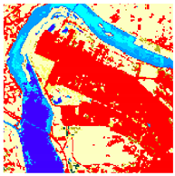 |
| Case B | 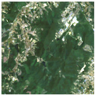 | 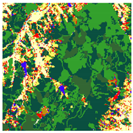 | 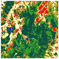 |
Disclaimer/Publisher’s Note: The statements, opinions and data contained in all publications are solely those of the individual author(s) and contributor(s) and not of MDPI and/or the editor(s). MDPI and/or the editor(s) disclaim responsibility for any injury to people or property resulting from any ideas, methods, instructions or products referred to in the content. |
© 2025 by the authors. Licensee MDPI, Basel, Switzerland. This article is an open access article distributed under the terms and conditions of the Creative Commons Attribution (CC BY) license (https://creativecommons.org/licenses/by/4.0/).
Share and Cite
Lee, K.; Baek, H.; Choi, C.-H.; Han, S.-H.; Park, S. Mapping Ecosystem Functional Groups in the Republic of Korea Based on the IUCN Global Ecosystem Typology. Remote Sens. 2025, 17, 1659. https://doi.org/10.3390/rs17101659
Lee K, Baek H, Choi C-H, Han S-H, Park S. Mapping Ecosystem Functional Groups in the Republic of Korea Based on the IUCN Global Ecosystem Typology. Remote Sensing. 2025; 17(10):1659. https://doi.org/10.3390/rs17101659
Chicago/Turabian StyleLee, Kyungil, Haedam Baek, Chul-Hyun Choi, Sang-Hak Han, and Seonyoung Park. 2025. "Mapping Ecosystem Functional Groups in the Republic of Korea Based on the IUCN Global Ecosystem Typology" Remote Sensing 17, no. 10: 1659. https://doi.org/10.3390/rs17101659
APA StyleLee, K., Baek, H., Choi, C.-H., Han, S.-H., & Park, S. (2025). Mapping Ecosystem Functional Groups in the Republic of Korea Based on the IUCN Global Ecosystem Typology. Remote Sensing, 17(10), 1659. https://doi.org/10.3390/rs17101659