Integrating Artificial Intelligence and UAV-Acquired Multispectral Imagery for the Mapping of Invasive Plant Species in Complex Natural Environments

 ,
,  , ,
, ,
Abstract
1. Introduction
Existing Studies
2. Methodology
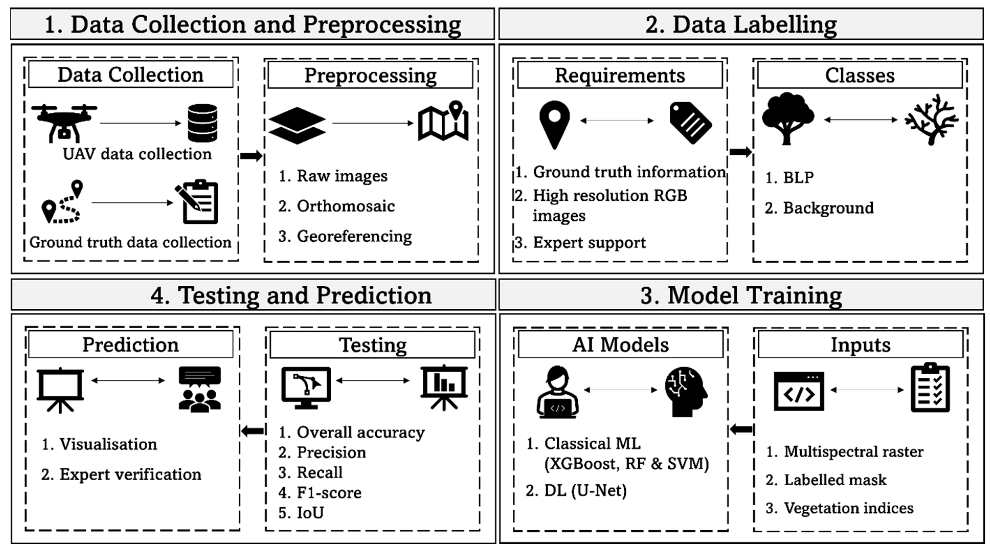
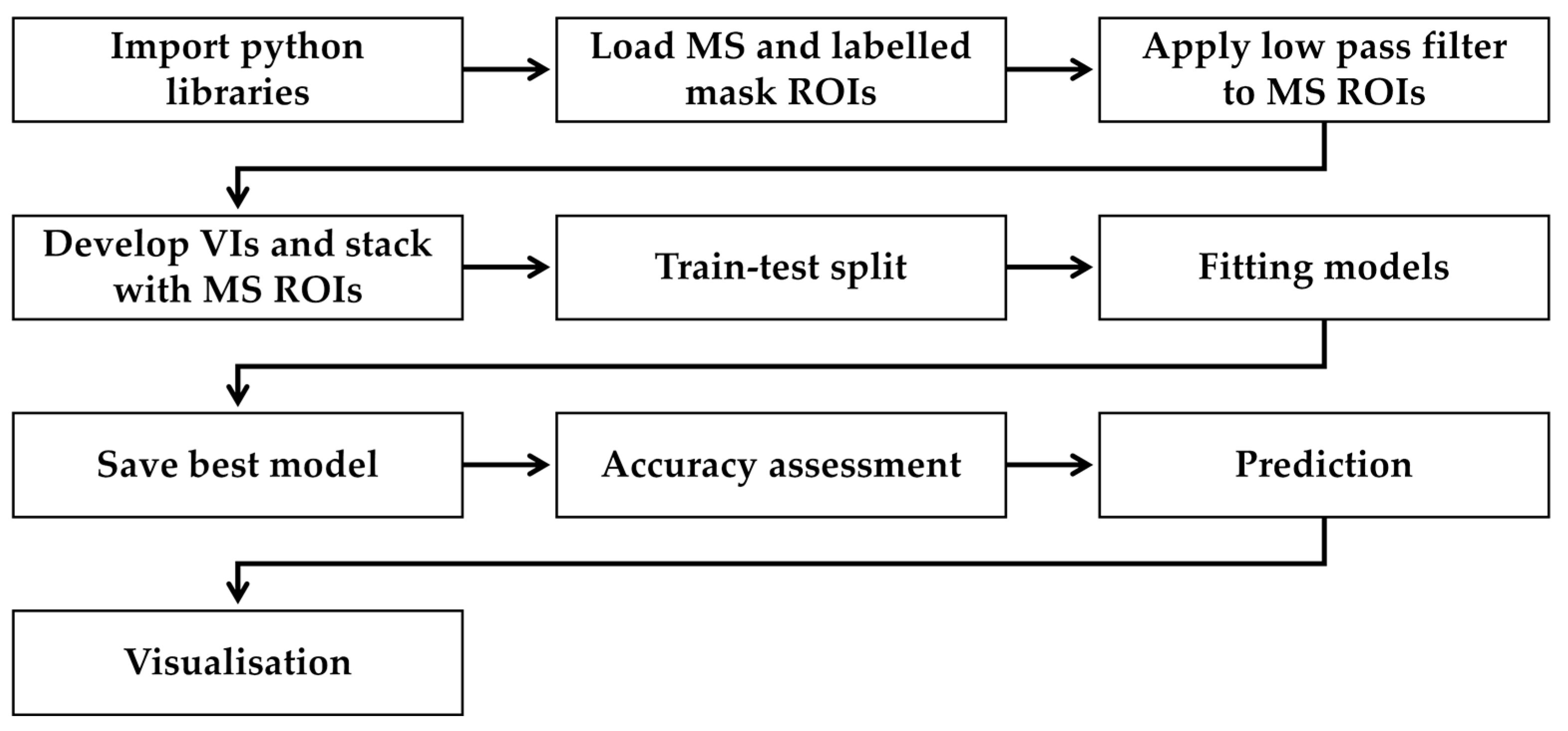
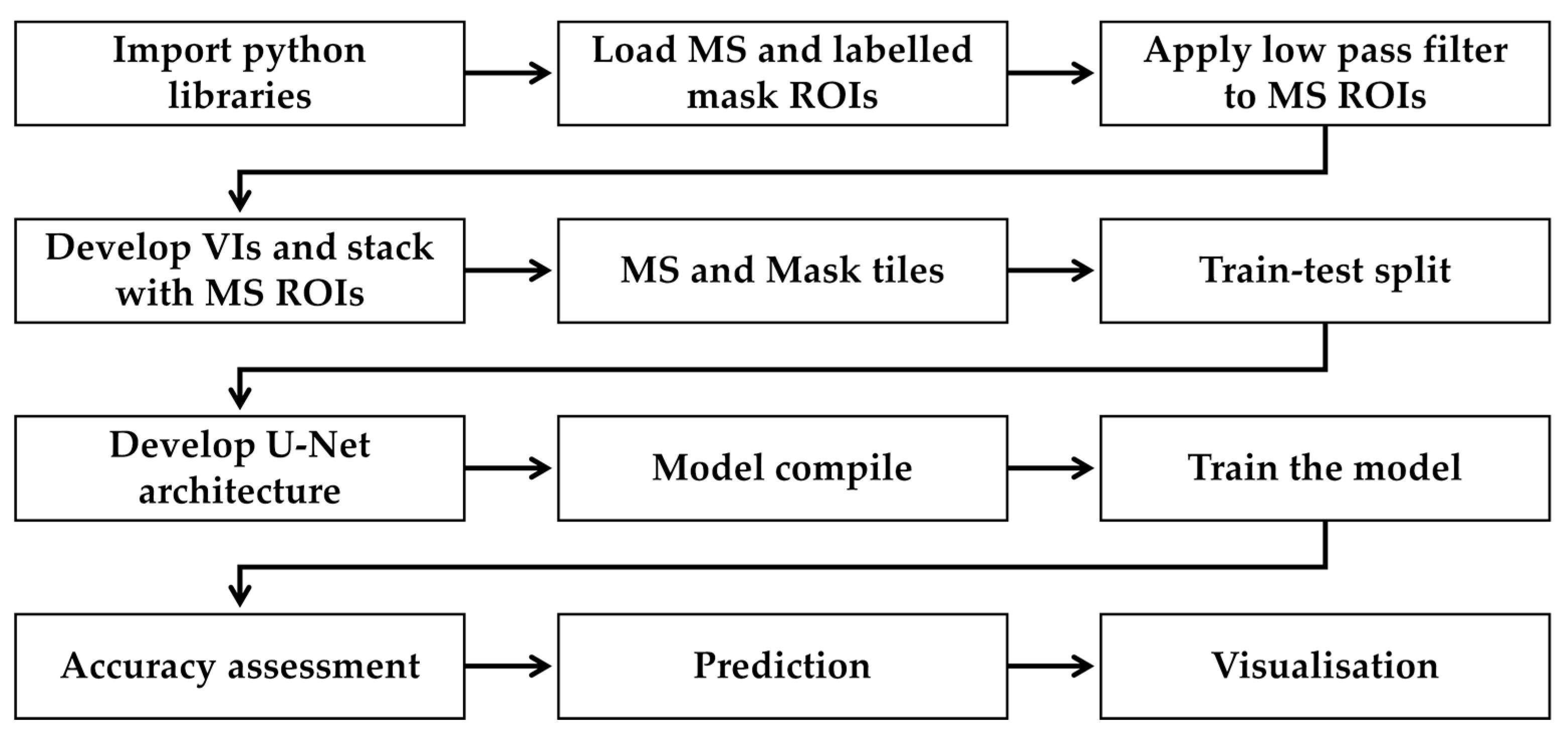
2.1. Processing Pipeline
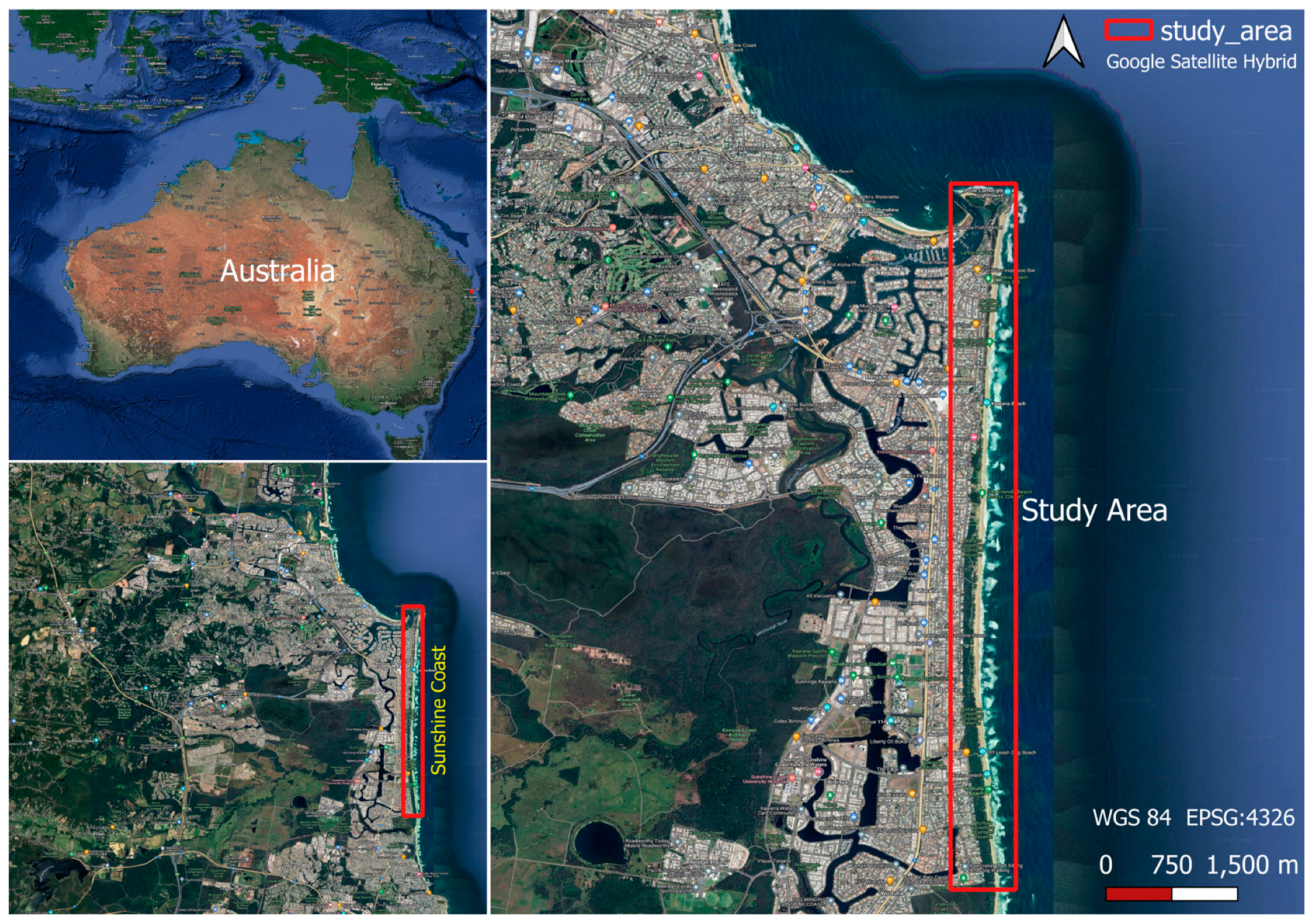
2.2. Study Location
2.3. Data Collection
UAV Data Collection
2.4. Ground Truth Data Collection
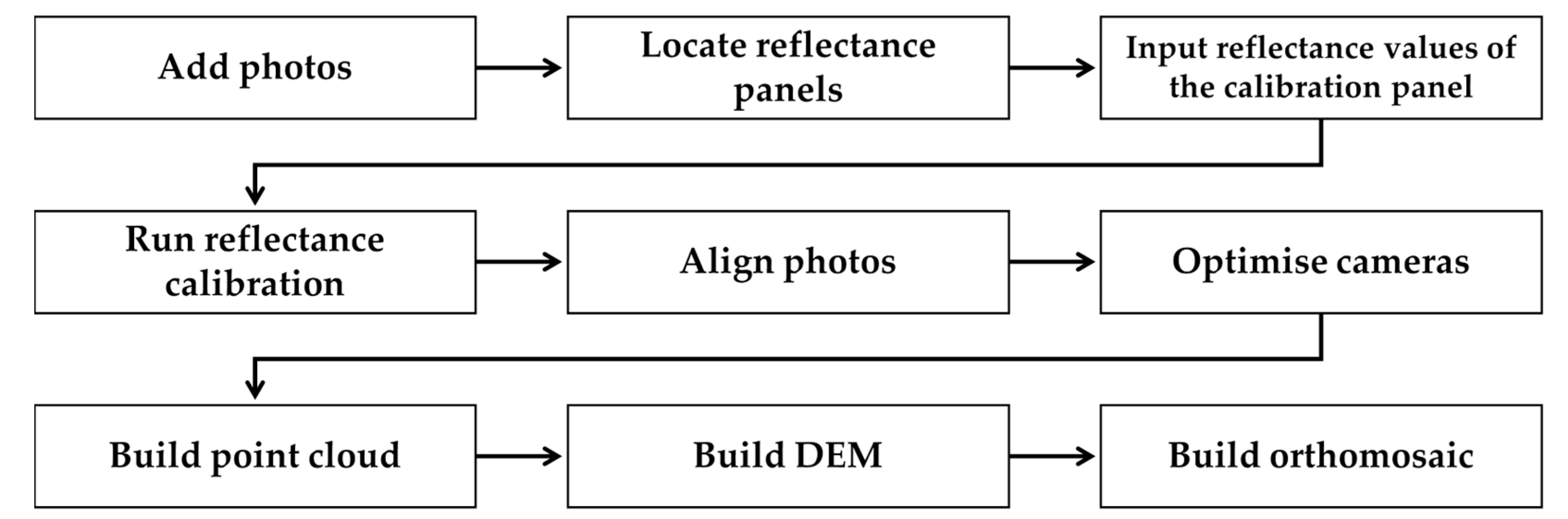
2.5. Preprocessing of UAV Imagery
Georeferencing
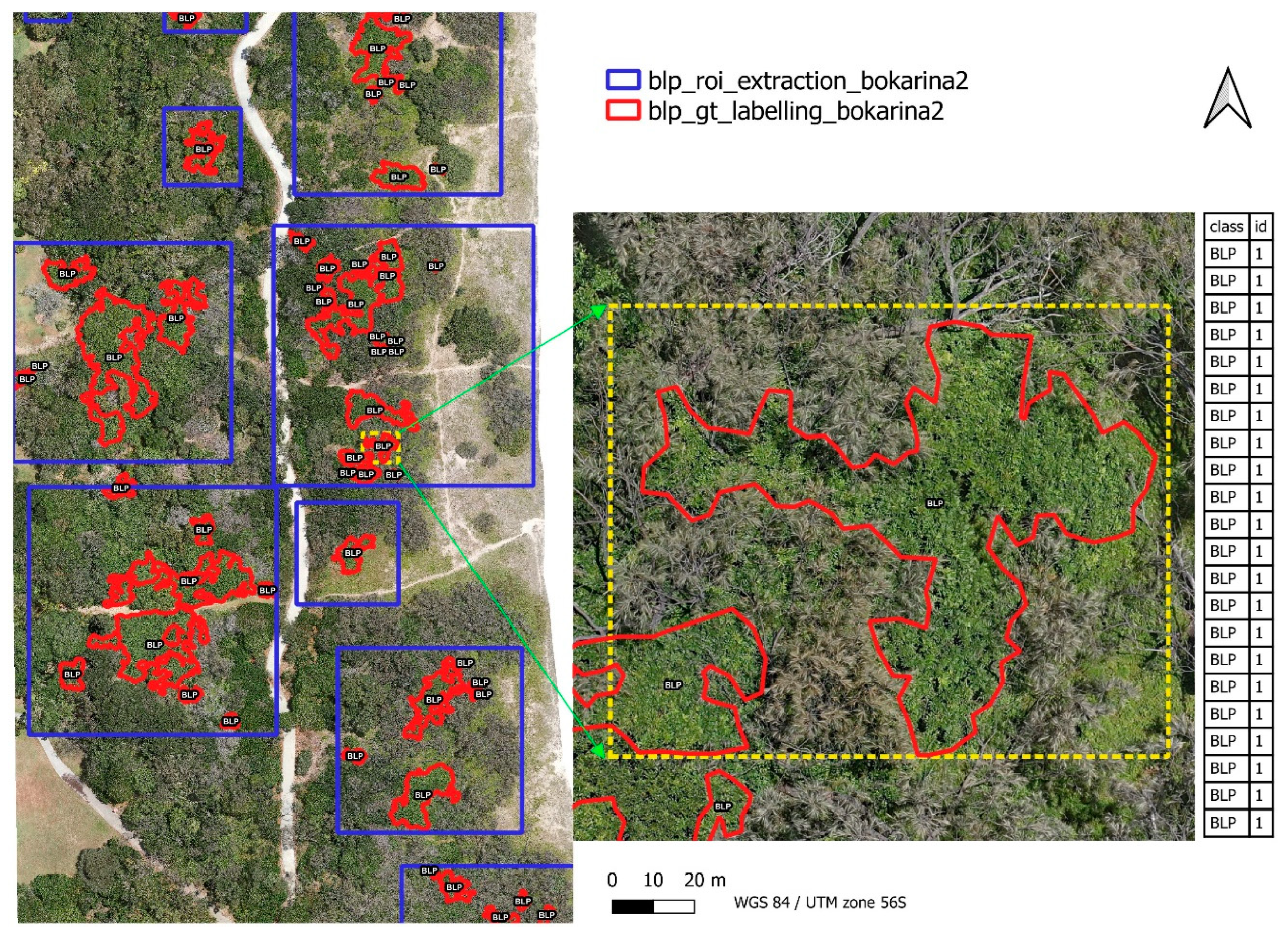
2.6. Data Labelling and Extraction of Region of Interest
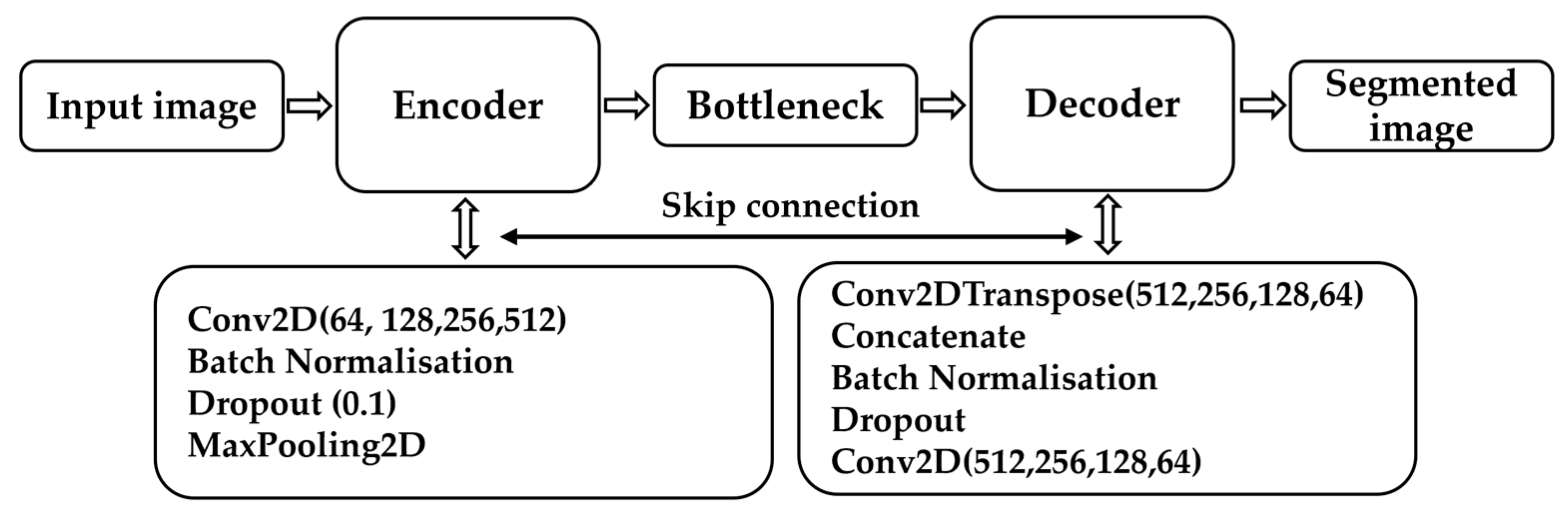
2.7. Machine Learning for BLP Semantic Segmentation
Estimation of Vegetation Indices and Feature Selection
2.8. Machine Learning Model Training
2.9. Parameter Tunning for Model Improvement
2.10. Model Testing
2.11. Model Prediction and Segmentation Map
3. Results
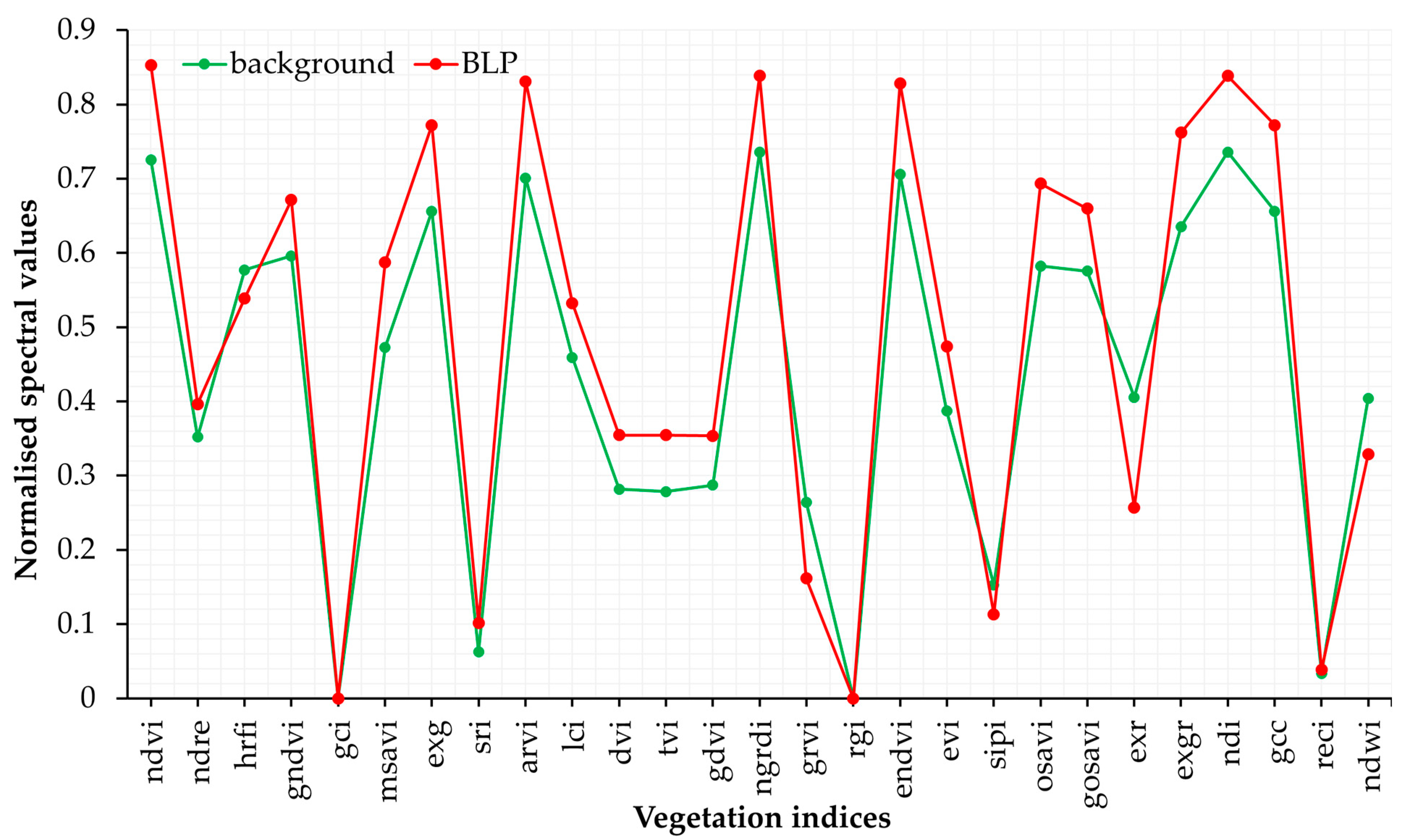
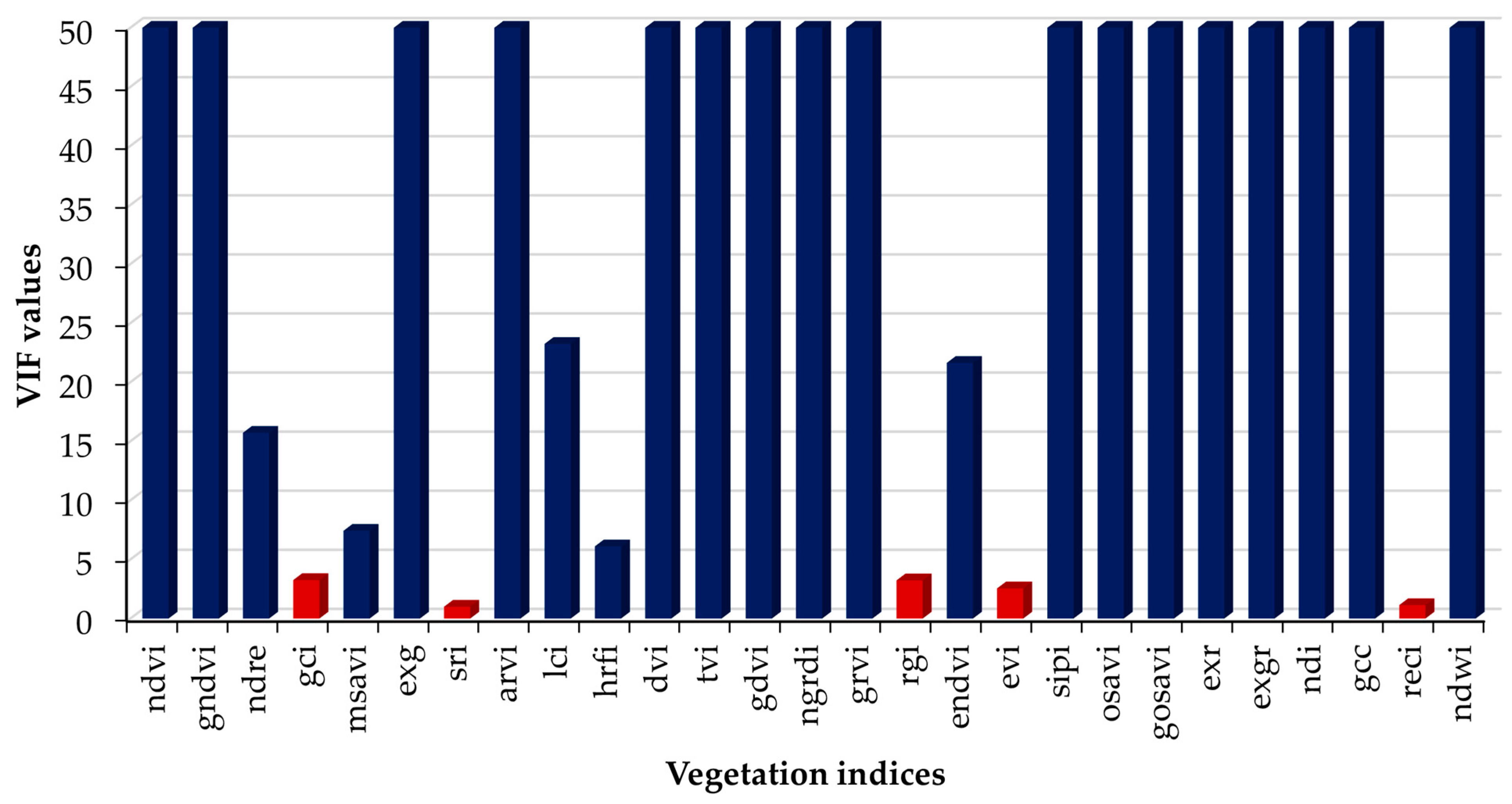
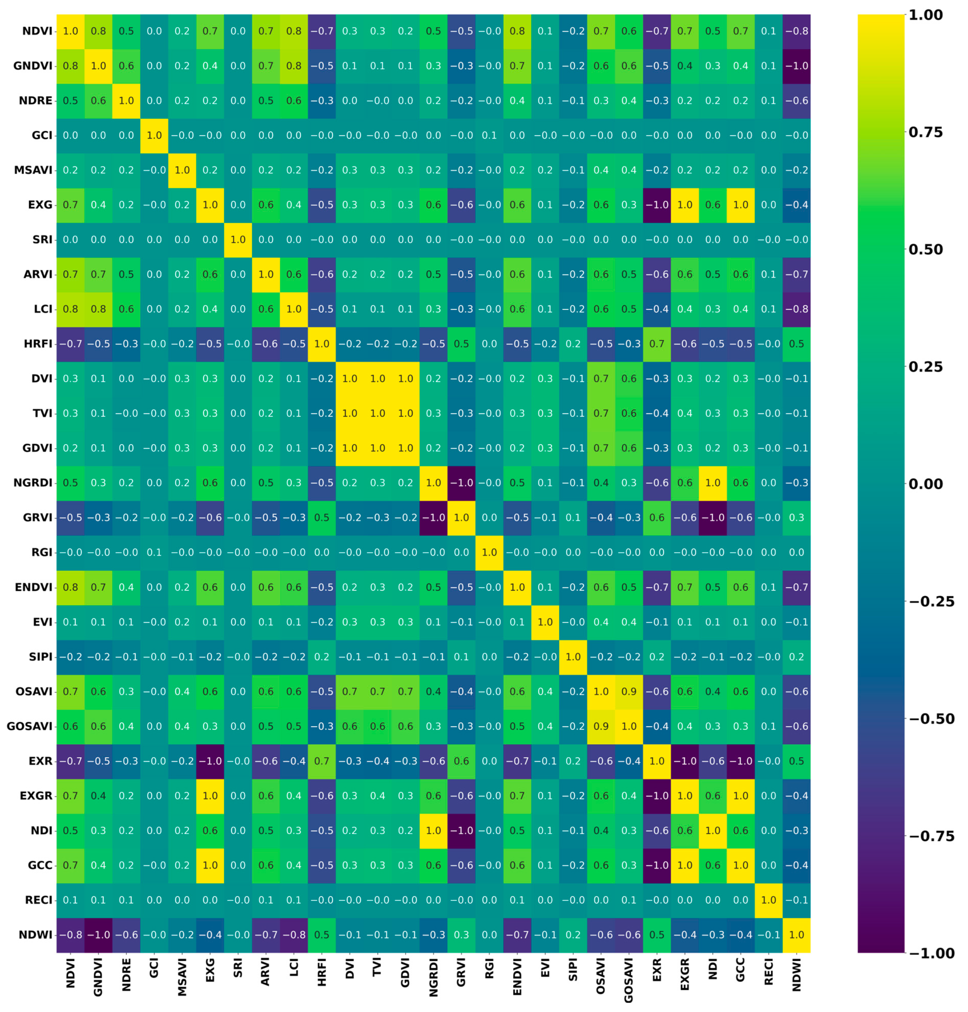
3.1. Selection of Vegetation Indices
3.2. Performance of Classical Machine Learning Models
3.3. Performance of U-Net Model
3.4. Training Plots
3.5. Cross Validation
3.6. Prediction of Multispectral ROIs from Testing Dataset
3.7. Visualisation of Prediction Maps
4. Discussion
5. Limitations of the Study
6. Conclusions and Recommendations
Author Contributions
Funding
Data Availability Statement
Acknowledgments
Conflicts of Interest
References
- Bolch, E.A.; Hestir, E.L.; Khanna, S. Performance and Feasibility of Drone-Mounted Imaging Spectroscopy for Invasive Aquatic Vegetation Detection. Remote Sens. 2021, 13, 582. [Google Scholar] [CrossRef] [Scilit]
- Abeysinghe, T.; Milas, A.S.; Arend, K.; Hohman, B.; Reil, P.; Gregory, A.; Vázquez-Ortega, A. Mapping Invasive Phragmites Australis in the Old Woman Creek Estuary Using UAV Remote Sensing and Machine Learning Classifiers. Remote Sens. 2019, 11, 1380. [Google Scholar] [CrossRef] [Scilit]
- da Silva, S.D.P.; Eugenio, F.C.; Fantinel, R.A.; Amaral, L.d.P.; dos Santos, A.R.; Mallmann, C.L.; dos Santos, F.D.; Pereira, R.S.; Ruoso, R. Modeling and Detection of Invasive Trees Using UAV Image and Machine Learning in a Subtropical Forest in Brazil. Ecol. Inform. 2023, 74, 101989. [Google Scholar] [CrossRef] [Scilit]
- Li, X.; Ba, Y.; Zhang, S.; Nong, M.; Zhang, M.; Wang, C. Sugarcane Nitrogen and Irrigation Level Prediction Based on UAV-Captured Multispectral Images at the Elongation Stage. bioRxiv 2020. [Google Scholar] [CrossRef] [Scilit]
- Hoffrén, R.; Lamelas, M.T.; de la Riva, J. UAV-Derived Photogrammetric Point Clouds and Multispectral Indices for Fuel Estimation in Mediterranean Forests. Remote Sens. Appl. 2023, 31, 100997. [Google Scholar] [CrossRef] [Scilit]
- Arnold, T.; De Biasio, M.; Fritz, A.; Leitner, R. UAV-Based Multispectral Environmental Monitoring. In SENSORS, 2010 IEEE; IEEE: Piscataway, NJ, USA, 2010; pp. 995–998. [Google Scholar] [CrossRef] [Scilit]
- Nebiker, S.; Annen, A.; Scherrer, M.; Oesch, D. A Light-Weight Multispectral Sensor for Micro UAV—Opportunities for Very High Resolution Airborne Remote Sensing. Int. Arch. Photogramm. Remote Sens. Spat. Inf. Sci. 2008, 37, 1193–1200. [Google Scholar]
- Diez, Y.; Kentsch, S.; Fukuda, M.; Caceres, M.L.L.; Moritake, K.; Cabezas, M. Deep Learning in Forestry Using Uav-Acquired Rgb Data: A Practical Review. Remote Sens. 2021, 13, 2837. [Google Scholar] [CrossRef] [Scilit]
- Zheng, J.Y.; Hao, Y.Y.; Wang, Y.C.; Zhou, S.Q.; Wu, W.B.; Yuan, Q.; Gao, Y.; Guo, H.Q.; Cai, X.X.; Zhao, B. Coastal Wetland Vegetation Classification Using Pixel-Based, Object-Based and Deep Learning Methods Based on RGB-UAV. Land 2022, 11, 2039. [Google Scholar] [CrossRef] [Scilit]
- Amarasingam, N.; Gonzalez, F.; Salgadoe, A.S.A.; Sandino, J.; Powell, K. Detection of White Leaf Disease in Sugarcane Crops Using UAV-Derived RGB Imagery with Existing Deep Learning Models. Remote Sens. 2022, 14, 6137. [Google Scholar] [CrossRef] [Scilit]
- Lucena, F.; Breunig, F.M.; Kux, H. The Combined Use of UAV-Based RGB and DEM Images for the Detection and Delineation of Orange Tree Crowns with Mask R-CNN: An Approach of Labeling and Unified Framework. Future Internet 2022, 14, 275. [Google Scholar] [CrossRef] [Scilit]
- Sun, Z.; Wang, X.; Wang, Z.; Yang, L.; Xie, Y.; Huang, Y. UAVs as Remote Sensing Platforms in Plant Ecology: Review of Applications and Challenges. J. Plant Ecol. 2021, 14, 1003–1023. [Google Scholar] [CrossRef] [Scilit]
- Khanal, S.; Kushal, K.C.; Fulton, J.P.; Shearer, S.; Ozkan, E. Remote Sensing in Agriculture—Accomplishments, Limitations, and Opportunities. Remote Sens. 2020, 12, 3783. [Google Scholar] [CrossRef] [Scilit]
- Hardin, P.J.; Lulla, V.; Jensen, R.R.; Jensen, J.R. Small Unmanned Aerial Systems (SUAS) for Environmental Remote Sensing: Challenges and Opportunities Revisited. GISci. Remote Sens. 2019, 56, 309–322. [Google Scholar] [CrossRef] [Scilit]
- Hardin, P.; Jensen, R. Small-Scale Unmanned Aerial Vehicles in Environmental Remote Sensing: Challenges and Opportunities. GISci. Remote Sens. 2011, 48, 99–111. [Google Scholar] [CrossRef] [Scilit]
- Amarasingam, N.; Ashan Salgadoe, A.S.; Powell, K.; Gonzalez, L.F.; Natarajan, S. A Review of UAV Platforms, Sensors, and Applications for Monitoring of Sugarcane Crops. Remote Sens. Appl. 2022, 26, 100712. [Google Scholar] [CrossRef] [Scilit]
- Berni, J.A.J.; Zarco-Tejada, P.J.; Suárez, L.; González-Dugo, V.; Fereres, E. Remote Sensing of Vegetation from UAV Platforms Using Lightweight Multispectral and Thermal Imaging Sensors. Int. Arch. Photogramm. Remote Sens. Spat. Inf. Sci. 2009, 38, 6. [Google Scholar]
- Alexandridis, T.K.; Tamouridou, A.A.; Pantazi, X.E.; Lagopodi, A.L.; Kashefi, J.; Ovakoglou, G.; Polychronos, V.; Moshou, D. Novelty Detection Classifiers in Weed Mapping: Silybum Marianum Detection on UAV Multispectral Images. Sensors 2017, 17, 2007. [Google Scholar] [CrossRef] [Scilit]
- Zhang, T.; Yang, Z.; Xu, Z.; Li, J. Wheat Yellow Rust Severity Detection by Efficient DF-UNet and UAV Multispectral Imagery. IEEE Sens. J. 2022, 22, 9057–9068. [Google Scholar] [CrossRef] [Scilit]
- Cruz, C.; McGuinness, K.; Perrin, P.M.; O’Connell, J.; Martin, J.R.; Connolly, J. Improving the Mapping of Coastal Invasive Species Using UAV Imagery and Deep Learning. Int. J. Remote Sens. 2023, 44, 5713–5735. [Google Scholar] [CrossRef] [Scilit]
- Samiappan, S.; Turnage, G.; Hathcock, L.A.; Moorhead, R. Mapping of Invasive Phragmites (Common Reed) in Gulf of Mexico Coastal Wetlands Using Multispectral Imagery and Small Unmanned Aerial Systems. Int. J. Remote Sens. 2017, 38, 2861–2882. [Google Scholar] [CrossRef] [Scilit]
- Di Gennaro, S.F.; Rizza, F.; Badeck, F.W.; Berton, A.; Delbono, S.; Gioli, B.; Toscano, P.; Zaldei, A.; Matese, A. UAV-Based High-Throughput Phenotyping to Discriminate Barley Vigour with Visible and near-Infrared Vegetation Indices. Int. J. Remote Sens. 2018, 39, 5330–5344. [Google Scholar] [CrossRef] [Scilit]
- Hill, D.J.; Tarasoff, C.; Whitworth, G.E.; Baron, J.; Bradshaw, J.L.; Church, J.S. Utility of Unmanned Aerial Vehicles for Mapping Invasive Plant Species: A Case Study on Yellow Flag Iris (Iris pseudacorus L.). Int. J. Remote Sens. 2017, 38, 2083–2105. [Google Scholar] [CrossRef] [Scilit]
- Tamouridou, A.A.; Alexandridis, T.K.; Pantazi, X.E.; Lagopodi, A.L.; Kashefi, J.; Moshou, D. Evaluation of UAV Imagery for Mapping Silybum Marianum Weed Patches. Int. J. Remote Sens. 2017, 38, 2246–2259. [Google Scholar] [CrossRef] [Scilit]
- Ahmed, O.S.; Shemrock, A.; Chabot, D.; Dillon, C.; Williams, G.; Wasson, R.; Franklin, S.E. Hierarchical Land Cover and Vegetation Classification Using Multispectral Data Acquired from an Unmanned Aerial Vehicle. Int. J. Remote Sens. 2017, 38, 2037–2052. [Google Scholar] [CrossRef] [Scilit]
- Tlebaldinova, A.; Karmenova, M.; Ponkina, E.; Bondarovich, A. CNN-Based Approaches for Weed Detection. In Proceedings of the 2022 10th International Scientific Conference on Computer Science, COMSCI 2022-Proceedings, Sofia, Bulgaria, 30 May–2 June 2022; Institute of Electrical and Electronics Engineers Inc.: Piscataway, NJ, USA, 2022. [Google Scholar]
- Sievers, O. CNN-Based Methods for Tree Species Detection in UAV Images; Linköping University: Linköping, Sweden, 2022. [Google Scholar]
- Zheng, Q.; Tian, X.; Yu, Z.; Jiang, N.; Elhanashi, A.; Saponara, S.; Yu, R. Application of Wavelet-Packet Transform Driven Deep Learning Method in PM2.5 Concentration Prediction: A Case Study of Qingdao, China. Sustain. Cities Soc. 2023, 92, 104486. [Google Scholar] [CrossRef] [Scilit]
- Zhao, X.; Yuan, Y.; Song, M.; Ding, Y.; Lin, F.; Liang, D.; Zhang, D. Use of Unmanned Aerial Vehicle Imagery and Deep Learning Unet to Extract Rice Lodging. Sensors 2019, 19, 3859. [Google Scholar] [CrossRef] [Scilit]
- Arun, R.A.; Umamaheswari, S.; Jain, A.V. Reduced U-Net Architecture for Classifying Crop and Weed Using Pixel-Wise Segmentation. In Proceedings of the 2020 IEEE International Conference for Innovation in Technology, INOCON 2020, Bengaluru, India, 6 November 2020; Institute of Electrical and Electronics Engineers Inc.: Piscataway, NJ, USA, 2020. [Google Scholar]
- Ye, W.; Lao, J.; Liu, Y.; Chang, C.C.; Zhang, Z.; Li, H.; Zhou, H. Pine Pest Detection Using Remote Sensing Satellite Images Combined with a Multi-Scale Attention-UNet Model. Ecol. Inform. 2022, 72, 101906. [Google Scholar] [CrossRef] [Scilit]
- Ronneberger, O.; Fischer, P.; Brox, T. U-Net: Convolutional Networks for Biomedical Image Segmentation. In Proceedings of the Medical Image Computing and Computer-Assisted Intervention–MICCAI 2015: 18th International Conference, Munich, Germany, 5–9 October 2015; Springer: Berlin/Heidelberg, Germany, 2015. [Google Scholar]
- He, Y.; Zhang, X.; Zhang, Z.; Fang, H. Automated Detection of Boundary Line in Paddy Field Using MobileV2-UNet and RANSAC. Comput. Electron. Agric. 2022, 194, 106697. [Google Scholar] [CrossRef] [Scilit]
- Yu, H.; Men, Z.; Bi, C.; Liu, H. Research on Field Soybean Weed Identification Based on an Improved UNet Model Combined With a Channel Attention Mechanism. Front. Plant Sci. 2022, 13, 890051. [Google Scholar] [CrossRef] [Scilit]
- Boyina, L.; Sandhya, G.; Vasavi, S.; Koneru, L.; Koushik, V. Weed Detection in Broad Leaves Using Invariant U-Net Model. In Proceedings of the ICCISc 2021—2021 International Conference on Communication, Control and Information Sciences, Proceedings, Idukki, India, 16–18 June 2021; Institute of Electrical and Electronics Engineers Inc.: Piscataway, NJ, USA, 2021. [Google Scholar]
- Sahin, H.M.; Miftahushudur, T.; Grieve, B.; Yin, H. Segmentation of Weeds and Crops Using Multispectral Imaging and CRF-Enhanced U-Net. Comput. Electron. Agric. 2023, 211, 107956. [Google Scholar] [CrossRef] [Scilit]
- Department of Agriculture and Fisheries. Broad-Leaved Pepper Tree Fact Sheet; Department of Agriculture and Fisheries: Canberra ACT, Australia, 2020.
- Xu, Z.; Shen, X.; Cao, L.; Coops, N.C.; Goodbody, T.R.H.; Zhong, T.; Zhao, W.; Sun, Q.; Ba, S.; Zhang, Z.; et al. Tree Species Classification Using UAS-Based Digital Aerial Photogrammetry Point Clouds and Multispectral Imageries in Subtropical Natural Forests. Int. J. Appl. Earth Obs. Geoinf. 2020, 92, 102173. [Google Scholar] [CrossRef] [Scilit]
- Hartling, S.; Sagan, V.; Maimaitijiang, M. Urban Tree Species Classification Using UAV-Based Multi-Sensor Data Fusion and Machine Learning. GIsci. Remote Sens. 2021, 58, 1250–1275. [Google Scholar] [CrossRef] [Scilit]
- Sivanandam, P.; Lucieer, A. Tree Detection and Species Classification in a Mixed Species Forest Using Unoccupied Aircraft System (UAS) RGB and Multispectral Imagery. Remote Sens. 2022, 14, 4963. [Google Scholar] [CrossRef] [Scilit]
- Dash, J.P.; Watt, M.S.; Paul, T.S.H.; Morgenroth, J.; Pearse, G.D. Early Detection of Invasive Exotic Trees Using UAV and Manned Aircraft Multispectral and LiDAR Data. Remote Sens. 2019, 11, 1812. [Google Scholar] [CrossRef] [Scilit]
- Otsu, K.; Pla, M.; Duane, A.; Cardil, A.; Brotons, L. Estimating the Threshold of Detection on Tree Crown Defoliation Using Vegetation Indices from Uas Multispectral Imagery. Drones 2019, 3, 80. [Google Scholar] [CrossRef] [Scilit]
- Franklin, S.E.; Ahmed, O.S.; Williams, G. Northern Conifer Forest Species Classification Using Multispectral Data Acquired from an Unmanned Aerial Vehicle. Photogramm. Eng. Remote Sens. 2017, 83, 501–507. [Google Scholar] [CrossRef] [Scilit]
- Abdollahnejad, A.; Panagiotidis, D. Tree Species Classification and Health Status Assessment for a Mixed Broadleaf-Conifer Forest with Uas Multispectral Imaging. Remote Sens. 2020, 12, 3722. [Google Scholar] [CrossRef] [Scilit]
- Sothe, C.; Dalponte, M.; de Almeida, C.M.; Schimalski, M.B.; Lima, C.L.; Liesenberg, V.; Miyoshi, G.T.; Tommaselli, A.M.G. Tree Species Classification in a Highly Diverse Subtropical Forest Integrating UAV-Based Photogrammetric Point Cloud and Hyperspectral Data. Remote Sens. 2019, 11, 1338. [Google Scholar] [CrossRef] [Scilit]
- Onishi, M.; Ise, T. Explainable Identification and Mapping of Trees Using UAV RGB Image and Deep Learning. Sci. Rep. 2021, 11, 903. [Google Scholar] [CrossRef] [Scilit]
- Kentsch, S.; Caceres, M.L.L.; Serrano, D.; Roure, F.; Diez, Y. Computer Vision and Deep Learning Techniques for the Analysis of Drone-Acquired Forest Images, a Transfer Learning Study. Remote Sens. 2020, 12, 1287. [Google Scholar] [CrossRef] [Scilit]
- Schiefer, F.; Kattenborn, T.; Frick, A.; Frey, J.; Schall, P.; Koch, B.; Schmidtlein, S. Mapping Forest Tree Species in High Resolution UAV-Based RGB-Imagery by Means of Convolutional Neural Networks. ISPRS J. Photogramm. Remote Sens. 2020, 170, 205–215. [Google Scholar] [CrossRef] [Scilit]
- Zou, K.; Chen, X.; Wang, Y.; Zhang, C.; Zhang, F. A Modified U-Net with a Specific Data Argumentation Method for Semantic Segmentation of Weed Images in the Field. Comput. Electron. Agric. 2021, 187, 106242. [Google Scholar] [CrossRef] [Scilit]
- Torres, D.L.; Feitosa, R.Q.; Happ, P.N.; La Rosa, L.E.C.; Junior, J.M.; Martins, J.; Bressan, P.O.; Gonçalves, W.N.; Liesenberg, V. Applying Fully Convolutional Architectures for Semantic Segmentation of a Single Tree Species in Urban Environment on High Resolution UAV Optical Imagery. Sensors 2020, 20, 563. [Google Scholar] [CrossRef] [Scilit] [PubMed]
- Wagner, F.H.; Sanchez, A.; Tarabalka, Y.; Lotte, R.G.; Ferreira, M.P.; Aidar, M.P.M.; Gloor, E.; Phillips, O.L.; Aragão, L.E.O.C. Using the U-Net Convolutional Network to Map Forest Types and Disturbance in the Atlantic Rainforest with Very High Resolution Images. Remote Sens. Ecol. Conserv. 2019, 5, 360–375. [Google Scholar] [CrossRef] [Scilit]
- Kattenborn, T.; Eichel, J.; Fassnacht, F.E. Convolutional Neural Networks Enable Efficient, Accurate and Fine-Grained Segmentation of Plant Species and Communities from High-Resolution UAV Imagery. Sci. Rep. 2019, 9, 17656. [Google Scholar] [CrossRef] [Scilit] [PubMed]
- Hamdi, Z.M.; Brandmeier, M.; Straub, C. Forest Damage Assessment Using Deep Learning on High Resolution Remote Sensing Data. Remote Sens. 2019, 11, 1976. [Google Scholar] [CrossRef] [Scilit]
- Freudenberg, M.; Nölke, N.; Agostini, A.; Urban, K.; Wörgötter, F.; Kleinn, C. Large Scale Palm Tree Detection in High Resolution Satellite Images Using U-Net. Remote Sens. 2019, 11, 312. [Google Scholar] [CrossRef] [Scilit]
- Imran, A.B.; Khan, K.; Ali, N.; Ahmad, N.; Ali, A.; Shah, K. Narrow Band Based and Broadband Derived Vegetation Indices Using Sentinel-2 Imagery to Estimate Vegetation Biomass. Glob. J. Environ. Sci. Manag. 2020, 6, 97–108. [Google Scholar] [CrossRef] [Scilit]
- Marcial-Pablo, M.d.J.; Gonzalez-Sanchez, A.; Jimenez-Jimenez, S.I.; Ontiveros-Capurata, R.E.; Ojeda-Bustamante, W. Estimation of Vegetation Fraction Using RGB and Multispectral Images from UAV. Int. J. Remote Sens. 2019, 40, 420–438. [Google Scholar] [CrossRef] [Scilit]
- Boiarskii, B. Comparison of NDVI and NDRE Indices to Detect Differences in Vegetation and Chlorophyll Content. J. Mech. Contin. Math. Sci. 2019, 4, 20–29. [Google Scholar] [CrossRef] [Scilit]
- Yu, R.; Luo, Y.; Zhou, Q.; Zhang, X.; Wu, D.; Ren, L. Early Detection of Pine Wilt Disease Using Deep Learning Algorithms and UAV-Based Multispectral Imagery. For. Ecol. Manag. 2021, 497, 119493. [Google Scholar] [CrossRef] [Scilit]
- Haboudane, D.; Miller, J.R.; Pattey, E.; Zarco-Tejada, P.J.; Strachan, I.B. Hyperspectral Vegetation Indices and Novel Algorithms for Predicting Green LAI of Crop Canopies: Modeling and Validation in the Context of Precision Agriculture. Remote Sens. Environ. 2004, 90, 337–352. [Google Scholar] [CrossRef] [Scilit]
- Kumar, V.; Sharma, A.; Bhardwaj, R.; Thukral, A.K. Comparison of Different Reflectance Indices for Vegetation Analysis Using Landsat-TM Data. Remote Sens. Appl. 2018, 12, 70–77. [Google Scholar] [CrossRef] [Scilit]
- Scher, C.L.; Karimi, N.; Glasenhardt, M.C.; Tuffin, A.; Cannon, C.H.; Scharenbroch, B.C.; Hipp, A.L. Application of Remote Sensing Technology to Estimate Productivity and Assess Phylogenetic Heritability. Appl. Plant Sci. 2020, 8, e11401. [Google Scholar] [CrossRef] [Scilit] [PubMed]
- Avola, G.; Di Gennaro, S.F.; Cantini, C.; Riggi, E.; Muratore, F.; Tornambè, C.; Matese, A. Remotely Sensed Vegetation Indices to Discriminate Field-Grown Olive Cultivars. Remote Sens. 2019, 11, 1242. [Google Scholar] [CrossRef] [Scilit]
- Xue, J.; Su, B. Significant Remote Sensing Vegetation Indices: A Review of Developments and Applications. J. Sens. 2017, 2017, 1353691. [Google Scholar] [CrossRef] [Scilit]
- Susantoro, T.M.; Wikantika, K.; Saepuloh, A.; Harsolumakso, A.H. Selection of Vegetation Indices for Mapping the Sugarcane Condition around the Oil and Gas Field of North West Java Basin, Indonesia. IOP Conf. Ser. Earth Environ. Sci. 2018, 149, 012001. [Google Scholar] [CrossRef] [Scilit]
- Capolupo, A.; Monterisi, C.; Tarantino, E. Landsat Images Classification Algorithm (LICA) to Automatically Extract Land Cover Information in Google Earth Engine Environment. Remote Sens. 2020, 12, 1201. [Google Scholar] [CrossRef] [Scilit]
- Kerkech, M.; Hafiane, A.; Canals, R. Deep Leaning Approach with Colorimetric Spaces and Vegetation Indices for Vine Diseases Detection in UAV Images. Comput. Electron. Agric. 2018, 155, 237–243. [Google Scholar] [CrossRef] [Scilit]
- Melillos, G.; Hadjimitsis, D.G. Using Simple Ratio (SR) Vegetation Index to Detect Deep Man-Made Infrastructures in Cyprus. In Detection and Sensing of Mines, Explosive Objects, and Obscured Targets XXV; SPIE: Bellingham, WA, USA, 2020; p. 22. [Google Scholar]
- Guo, Y.; Fu, Y.H.; Chen, S.; Robin Bryant, C.; Li, X.; Senthilnath, J.; Sun, H.; Wang, S.; Wu, Z.; de Beurs, K. Integrating Spectral and Textural Information for Identifying the Tasseling Date of Summer Maize Using UAV Based RGB Images. Int. J. Appl. Earth Obs. Geoinf. 2021, 102, 102435. [Google Scholar] [CrossRef] [Scilit]
- Alabi, T.R.; Abebe, A.T.; Chigeza, G.; Fowobaje, K.R. Estimation of Soybean Grain Yield from Multispectral High-Resolution UAV Data with Machine Learning Models in West Africa. Remote Sens. Appl. 2022, 27, 100782. [Google Scholar] [CrossRef] [Scilit]
- Effiom, A.E.; van Leeuwen, L.M.; Nyktas, P.; Okojie, J.A.; Erdbrügger, J. Combining Unmanned Aerial Vehicle and Multispectral Pleiades Data for Tree Species Identification, a Prerequisite for Accurate Carbon Estimation. J. Appl. Remote Sens. 2019, 13, 1. [Google Scholar] [CrossRef] [Scilit]
- Kampen, M.; Mund, J.-P.; Lederbauer, S.; Immitzer, M. UAV-Based Multispectral Data for Tree Species Classification and Tree Vitality Analysis; Dreiländertagung der DGPF, der OVG und der SGPF: Wien, Österreich, 2019. [Google Scholar]
- Guo, Q.; Zhang, J.; Guo, S.; Ye, Z.; Deng, H.; Hou, X.; Zhang, H. Urban Tree Classification Based on Object-Oriented Approach and Random Forest Algorithm Using Unmanned Aerial Vehicle (UAV) Multispectral Imagery. Remote Sens. 2022, 14, 3885. [Google Scholar] [CrossRef] [Scilit]
- Tu, Y.H.; Johansen, K.; Phinn, S.; Robson, A. Measuring Canopy Structure and Condition Using Multi-Spectral UAS Imagery in a Horticultural Environment. Remote Sens. 2019, 11, 269. [Google Scholar] [CrossRef] [Scilit]
- Kislov, D.E.; Korznikov, K.A. Automatic Windthrow Detection Using Very-High-Resolution Satellite Imagery and Deep Learning. Remote Sens. 2020, 12, 1145. [Google Scholar] [CrossRef] [Scilit]
- Chen, X.; Shen, X.; Cao, L. Tree Species Classification in Subtropical Natural Forests Using High-Resolution UAV RGB and SuperView-1 Multispectral Imageries Based on Deep Learning Network Approaches: A Case Study within the Baima Snow Mountain National Nature Reserve, China. Remote Sens. 2023, 15, 2697. [Google Scholar] [CrossRef] [Scilit]
- Voitik, A.; Kravchenko, V.; Pushka, O.; Kutkovetska, T.; Shchur, T.; Kocira, S. Comparison of NDVI, NDRE, MSAVI and NDSI Indices for Early Diagnosis of Crop Problems. Agric. Eng. 2023, 27, 47–57. [Google Scholar] [CrossRef] [Scilit]
- Gurung, R.B.; Breidt, F.J.; Dutin, A.; Ogle, S.M. Predicting Enhanced Vegetation Index (EVI) Curves for Ecosystem Modeling Applications. Remote Sens. Environ. 2009, 113, 2186–2193. [Google Scholar] [CrossRef] [Scilit]
- Rondeaux, G.; Steven, M.; Baret, F. Optimization of Soil-Adjusted Vegetation Indices. Remote Sens. Environ. 1996, 55, 95–107. [Google Scholar] [CrossRef] [Scilit]
- Xu, Z.Y.; Sun, B.; Zhang, W.F.; Li, Y.F.; Yan, Z.Y.; Yue, W.; Teng, S.H. An Evaluation of a Remote Sensing Method Based on Optimized Triangular Vegetation Index TVI for Aboveground Shrub Biomass Estimation in Shrub-Encroached Grassland. Acta Prataculturae Sin. 2023, 32, 1. [Google Scholar]
- Naji, T.A.H. Study of Vegetation Cover Distribution Using DVI, PVI, WDVI Indices with 2D-Space Plot. Proc. J. Phys. Conf. Ser. 2018, 1003, 012083. [Google Scholar] [CrossRef] [Scilit]
- Gunathilaka, M.D.K.L. Modelling the Behavior of DVI and IPVI Vegetation Indices Using Multi-Temporal Remotely Sensed Data. Int. J. Environ. Eng. Educ. 2021, 3, 9–16. [Google Scholar] [CrossRef] [Scilit]







| Specification | MicaSense Altum-PT |
|---|---|
| Weight | 577 g |
| Spectral Bands | Blue (475 nm center, 32 nm bandwidth), Green (560 nm center, 27 nm bandwidth), Red (668 nm center, 14 nm bandwidth), Red-edge (717 nm center, 12 nm bandwidth), and Near-IR (842 nm center, 57 nm bandwidth) |
| Sensor Resolution | 2064 × 1544 (3.2 MP per MS band) 4112 × 3008 (12 MP panchromatic band) 320 × 256 thermal infrared |
| Field of View | 50° HFOV × 38° VFOV (MS) 46° HFOV × 35° VFOV (panchromatic) 48° × 40° (thermal) |
| Image | UAV | Sensor | AGL | GSD | Speed | Front Overlap | Side Overlap |
|---|---|---|---|---|---|---|---|
| RGB | DJI Matrice 300 | DJI Zenmuse–P1 | 45 m | 0.57 cm/pixel | 6.1 ms−1 | 80% | 70% |
| MS | DJI Matrice 300 | MicaSense Altum–PT | 45 m–50 m | 2.59–2.88 cm/pixel | 5.9 ms−1 | 80% | 80% |
| Mapping Area | Date of UAV Data Collation | |
|---|---|---|
| RGB | Multispectral | |
| Pt Cartwright | 24 October 2022, 7 November 2022, 9 November 2022 | 14 November 2022, 22 November 2022 |
| Buddina | 26 October 2022, 7 November 2022 | 15 November 2022 |
| Warana | 9 November 2022 | 17 November 2022 |
| Bokarina | 28 November 2022 | 18 November 2022, 21 November 2022 |
| Wurtulla | 28 November 2022 | 21 November 2022, 22 November 2022 |
| Mapping Area | Time Taken | Date of Ground Truth Data Collection |
|---|---|---|
| Pt Cartwright | 2:00 | 23 March 2023 |
| Buddina (BA 201–202, BA 211–212) | 2:00 | 23 March 2023 |
| Warana 237–238 | 7:00 | 16 March 2023 |
| Warana 233–234 | 6:30 | 27 March 2023 |
| Bokarina 242–243 | 11:00 | 16 March 2023, 3 April 2023 |
| Bokarina 245–246 | 3:00 | 3 April 2023 |
| Wurtulla 248–249 | 11:00 | 31 March 2023 |
| Wurtulla 251–252 | 5:00 | 31 March 2023 |
| Total | 47.5 h |
| Vegetation Indices | Formula | References |
|---|---|---|
| Normalised Difference Vegetation Index (NDVI) | [55] | |
| Green Normalised Difference Vegetation Index (GNDVI) | [56] | |
| Normalised Difference Red Edge Index (NDRE) | NDRE = | [57] |
| Leaf Chlorophyll Index (LCI) | LCI = | [58] |
| Difference Vegetation Index (DVI) | DVI = NIR − R | [59] |
| Enhanced Vegetation Index (EVI) | EVI = | [58] |
| Triangular Vegetation Index (TVI) | TVI = 60(NIR − G) − 100(R − G) | [58] |
| Green Chlorophyll Index (GCI) | [60] | |
| Green Difference Vegetation Index (GDVI) | [61] | |
| Normalised Green Red Difference Index (NGRDI) | [62] | |
| Modified Soil-Adjusted Vegetation Index (MSAVI) | MASVI = | [63] |
| Atmospherically Resistant Vegetation Index (ARVI) | [63] | |
| Structure Insensitive Pigment Index (SIPI) | [64] | |
| Optimised Soil-Adjusted Vegetation Index (OSAVI) | OSAVI = | [65] |
| Green Optimised Soil Adjusted Vegetation Index (GOSAVI) | GOSAVI = | [65] |
| Excess Green (ExG) | [66] | |
| Excess Red (ExR) | [66] | |
| Excess Green Red (ExGR) | [66] | |
| Green, Red Vegetation Index (GRVI) | [66] | |
| Normalised Difference Index (NDI) | [66] | |
| Red Green Index (RGI) | [66] | |
| Enhanced Normalised Difference Vegetation Index (ENDVI) | [64] | |
| Simple Ratio Index (SRI) | [67] | |
| Green Chromatic Coordinate (GCC) | [68] | |
| Red edge chlorophyll Index (RECI) | [69] | |
| Normalised Difference Water Index (NDWI) | [69] |
| Processing Stages | Key Parameters | Configurations |
|---|---|---|
| Pre processing | Bands | Without bands, 5 bands, Top 2 bands |
| Vegetation indices (VIs) | Without VIs, Top 5 VIs, Top 3 VIs | |
| Patch size | 32, 64, 128, 256, 512 | |
| Low pass filter | Without filter, 3 × 3, 5 × 5 | |
| Gaussian blur filter | Without filter, 3 × 3, 5 × 5 | |
| Train test split | 20%, 25%, 30%, 40% | |
| Model Architecture | Convolution layers | 32–024, 64–1024, 128–1024, 16–512, 32–512, 16–256, 32–256 |
| Dropout | 0.1, 0.2 | |
| Model compile and Training | Learning rate | 0.1, 0.01, 0.001, 0.0001 |
| Batch size | 10, 15, 20, 25, 30, 35, 40, 45 | |
| Epochs | 50, 75, 100, 150, 200, 250, 300, 400, 500, 600 |
| Spectral Signature | VIF | Correlation Matrix | PCA |
|---|---|---|---|
| MSAVI | SRI | GCI | GOSAVI |
| EVI | RECI | SRI | NGRDI |
| OSAVI | EVI | RGI | GRVI |
| TVI | GCI | OSAVI | EVI |
| DVI | RGI | RECI | RECI |
| Class | XGBoost | RF | SVM | |||||||||
|---|---|---|---|---|---|---|---|---|---|---|---|---|
| Training and Validation | Training and Validation | Training and Validation | ||||||||||
| P | R | F1 | OA | P | R | F1 | OA | P | R | F1 | OA | |
| Background | 94% | 95% | 94% | 91% | 95% | 92% | 93% | 93% | 86% | 62% | 72% | 76% |
| BLP | 74% | 68% | 71% | 92% | 95% | 94% | 70% | 90% | 79% | |||
| Class | Testing | Testing | Testing | |||||||||
| P | R | F1 | OA | P | R | F1 | OA | P | R | F1 | OA | |
| Background | 86% | 90% | 88% | 80% | 91% | 81% | 85% | 77% | 96% | 55% | 70% | 62% |
| BLP | 45% | 35% | 39% | 43% | 64% | 51% | 32% | 90% | 47% | |||
| Feature Sets | Matrix | Training and Validation | Testing | ||
|---|---|---|---|---|---|
| Background | BLP | Background | BLP | ||
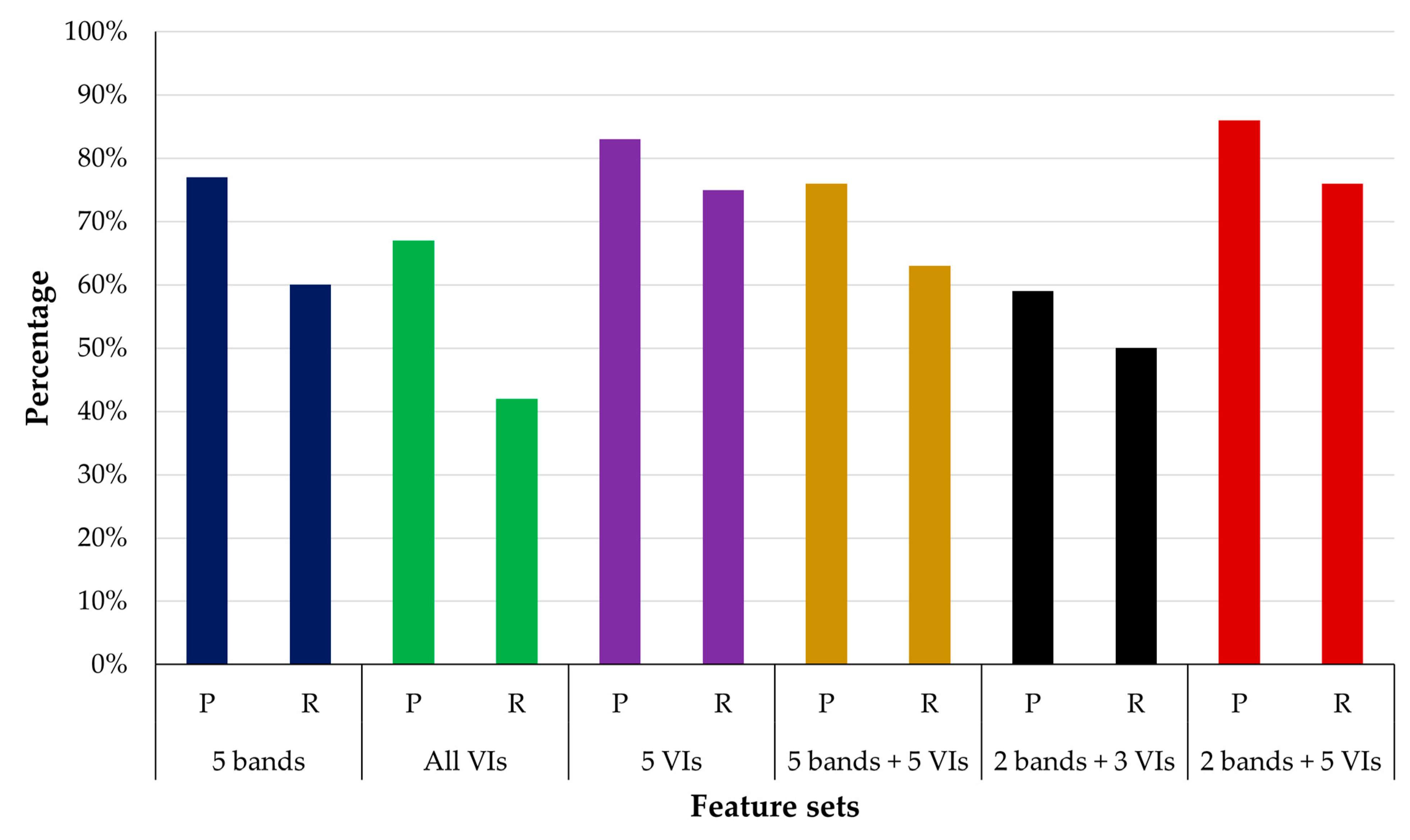
| 5 bands (Blue, Green, Red, NIR, and Red-edge) only | P | 94% | 89% | 92% | 77% |
| R | 96% | 85% | 96% | 60% | |
| F1 | 95% | 87% | 94% | 68% | |
| IoU | 90% | 76% | 88% | 51% | |
| All VIs (27) | P | 95% | 61% | 92% | 67% |
| R | 93% | 68% | 97% | 42% | |
| F1 | 94% | 64% | 94% | 52% | |
| IoU | 89% | 47% | 89% | 35% | |
| Feature Sets | Matrix | Training and Validation | Testing | ||
|---|---|---|---|---|---|
| Background | BLP | Background | BLP | ||
| 5 VIs from spectral signature plot (MSAVI, EVI, OSAVI, TVI, DVI) only | P | 96% | 82% | 88% | 83% |
| R | 93% | 87% | 92% | 75% | |
| F1 | 94% | 85% | 90% | 79% | |
| IoU | 90% | 81% | 81% | 65% | |
| 5 VIs from VIF (SRI, RECI, EVI, GCI, RGI) | P | 69% | 49% | 70% | 84% |
| R | 83% | 31% | 97% | 24% | |
| F1 | 75% | 38% | 82% | 38% | |
| IoU | 60% | 23% | 69% | 23% | |
| 5 VIs from correlation (GCI, SRI, RGI, OSAVI, RECI) | P | 90% | 68% | 83% | 83% |
| R | 78% | 84% | 93% | 64% | |
| F1 | 83% | 75% | 87% | 72% | |
| IoU | 72% | 66% | 78% | 56% | |
| 5 VIs from PCA (GOSAVI, NGRDI, GRVI, EVI, RECI) | P | 81% | 83% | 70% | 71% |
| R | 93% | 59% | 94% | 25% | |
| F1 | 87% | 69% | 80% | 37% | |
| IoU | 76% | 52% | 67% | 23% | |
| Feature Sets | Matrix | Training and Validation | Testing | ||
|---|---|---|---|---|---|
| Background | BLP | Background | BLP | ||
| 2 bands (NIR, and Red-edge) and 3 VIs (MSAVI, EVI, OSAVI) | P | 94% | 53% | 92% | 59% |
| R | 92% | 61% | 94% | 50% | |
| F1 | 93% | 57% | 93% | 54% | |
| IoU | 87% | 39% | 87% | 37% | |
| 2 bands (NIR, and Red-edge) and 5 VIs from spectral signature plot ((MSAVI, EVI, OSAVI, TVI, DVI)) | P | 94% | 83% | 88% | 86% |
| R | 95% | 81% | 93% | 76% | |
| F1 | 94% | 82% | 90% | 81% | |
| IoU | 89% | 89% | 82% | 68% | |
Disclaimer/Publisher’s Note: The statements, opinions and data contained in all publications are solely those of the individual author(s) and contributor(s) and not of MDPI and/or the editor(s). MDPI and/or the editor(s) disclaim responsibility for any injury to people or property resulting from any ideas, methods, instructions or products referred to in the content. |
© 2024 by the authors. Licensee MDPI, Basel, Switzerland. This article is an open access article distributed under the terms and conditions of the Creative Commons Attribution (CC BY) license (https://creativecommons.org/licenses/by/4.0/).
Share and Cite
Amarasingam, N.; Vanegas, F.; Hele, M.; Warfield, A.; Gonzalez, F. Integrating Artificial Intelligence and UAV-Acquired Multispectral Imagery for the Mapping of Invasive Plant Species in Complex Natural Environments. Remote Sens. 2024, 16, 1582. https://doi.org/10.3390/rs16091582
Amarasingam N, Vanegas F, Hele M, Warfield A, Gonzalez F. Integrating Artificial Intelligence and UAV-Acquired Multispectral Imagery for the Mapping of Invasive Plant Species in Complex Natural Environments. Remote Sensing. 2024; 16(9):1582. https://doi.org/10.3390/rs16091582
Chicago/Turabian StyleAmarasingam, Narmilan, Fernando Vanegas, Melissa Hele, Angus Warfield, and Felipe Gonzalez. 2024. "Integrating Artificial Intelligence and UAV-Acquired Multispectral Imagery for the Mapping of Invasive Plant Species in Complex Natural Environments" Remote Sensing 16, no. 9: 1582. https://doi.org/10.3390/rs16091582
APA StyleAmarasingam, N., Vanegas, F., Hele, M., Warfield, A., & Gonzalez, F. (2024). Integrating Artificial Intelligence and UAV-Acquired Multispectral Imagery for the Mapping of Invasive Plant Species in Complex Natural Environments. Remote Sensing, 16(9), 1582. https://doi.org/10.3390/rs16091582