Article

Integrating Artificial Intelligence and UAV-Acquired Multispectral Imagery for the Mapping of Invasive Plant Species in Complex Natural Environments


1
QUT Centre for Robotics, School of Electrical Engineering and Robotics, Faculty of Engineering, Queensland University of Technology (QUT), 2 George Street, Brisbane City, QLD 4000, Australia
2
Department of Biosystems Technology, Faculty of Technology, South Eastern University of Sri Lanka, University Park, Oluvil 32360, Sri Lanka
3
Sunshine Coast Regional Council, Sunshine Coast, QLD 4560, Australia
*
Author to whom correspondence should be addressed.
Remote Sens. 2024, 16(9), 1582; https://doi.org/10.3390/rs16091582
Submission received: 19 March 2024 / Revised: 22 April 2024 / Accepted: 26 April 2024 / Published: 29 April 2024
(This article belongs to the Special Issue Remote Sensing for Management of Invasive Species)

Abstract

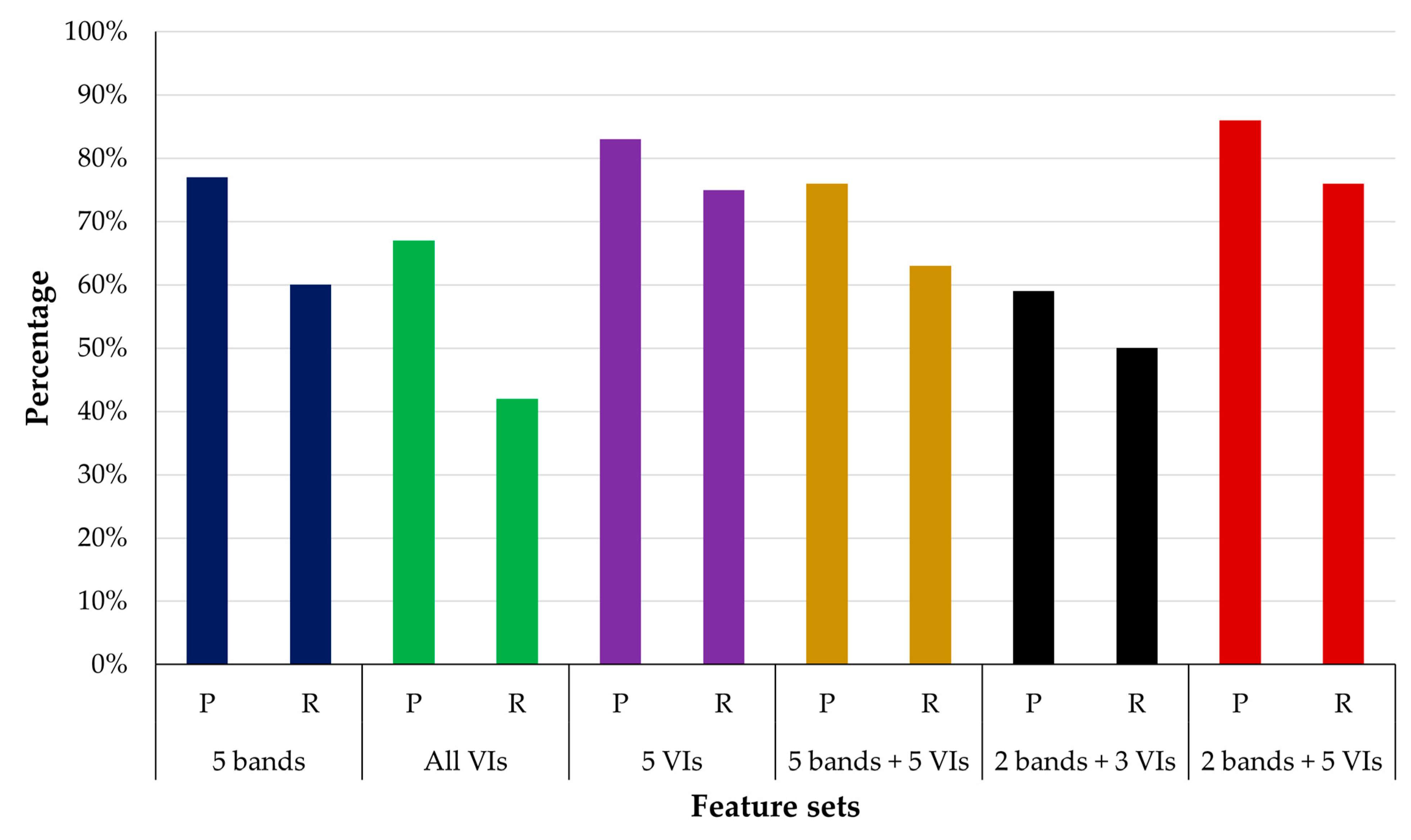
The proliferation of invasive plant species poses a significant ecological threat, necessitating effective mapping strategies for control and conservation efforts. Existing studies employing unmanned aerial vehicles (UAVs) and multispectral (MS) sensors in complex natural environments have predominantly relied on classical machine learning (ML) models for mapping plant species in natural environments. However, a critical gap exists in the literature regarding the use of deep learning (DL) techniques that integrate MS data and vegetation indices (VIs) with different feature extraction techniques to map invasive species in complex natural environments. This research addresses this gap by focusing on mapping the distribution of the Broad-leaved pepper (BLP) along the coastal strip in the Sunshine Coast region of Southern Queensland in Australia. The methodology employs a dual approach, utilising classical ML models including Random Forest (RF), eXtreme Gradient Boosting (XGBoost), and Support Vector Machine (SVM) in conjunction with the U-Net DL model. This comparative analysis allows for an in-depth evaluation of the performance and effectiveness of both classical ML and advanced DL techniques in mapping the distribution of BLP along the coastal strip. Results indicate that the DL U-Net model outperforms classical ML models, achieving a precision of 83%, recall of 81%, and F1–score of 82% for BLP classification during training and validation. The DL U-Net model attains a precision of 86%, recall of 76%, and F1–score of 81% for BLP classification, along with an Intersection over Union (IoU) of 68% on the separate test dataset not used for training. These findings contribute valuable insights to environmental conservation efforts, emphasising the significance of integrating MS data with DL techniques for the accurate mapping of invasive plant species.
Keywords: broad-leaved pepper; convolutional neural network; deep learning; drone; machine learning; remote sensing broad-leaved pepper; convolutional neural network; deep learning; drone; machine learning; remote sensing