Article

Multidecadal Changes in the Flow Velocity and Mass Balance of the Hailuogou Glacier in Mount Gongga, Southeastern Tibetan Plateau

1
School of Resource, Environment and Safety Engineering, Hunan University of Science and Technology, Xiangtan 411201, China
2
School of Physical Education, Hunan University of Science and Technology, Xiangtan 411201, China
*
Author to whom correspondence should be addressed.
Remote Sens. 2024, 16(3), 571; https://doi.org/10.3390/rs16030571
Submission received: 22 December 2023 / Revised: 30 January 2024 / Accepted: 31 January 2024 / Published: 2 February 2024
(This article belongs to the Section Environmental Remote Sensing)

Abstract

:
Maritime glaciers in the southeastern Tibetan Plateau (TP) have experienced important changes in mass and dynamics over the past decades, challenging the regional water supply and glacier-related hazards. However, knowledge about long-term variations in the surface velocity and mass balance of maritime glaciers remains incomplete due to the lack of representative observations in the southeastern TP. In this study, offset tracking is employed to measure spatiotemporal variation in the surface velocity of the Hailuogou Glacier (HLG) in Mount Gongga of the southeastern TP using Sentinel-1A imagery, while the time series of the HLG mass balance is reconstructed since 1950 by a physically based energy–mass balance model. Our satellite-based results find that HLG surface velocity shows significant spatial heterogeneity with a double-peak pattern along the flow line, and sustained slowdown below the icefall zone has been observed during the past nearly 40 years, although the icefall zone and the area above it have become relatively active. Our modeling indicates a persistent increase in mass loss over the last seven decades with an average rate of −0.58 m water equivalent (w.e.) year−1, which has accelerated in the past two decades. Sustained slowdown on the glacier is concomitant with pronounced negative mass balance, thereby enhancing glacier wastage in recent decades. The long-term trend in HLG mass loss is mainly driven by an increase in positive air temperature that decreases surface albedo and solid precipitation ratio and increases longwave incoming radiation, besides the influence of supraglacial debris cover. Large-scale atmospheric circulation patterns in the Eurasian region provide important implications for regional-to-local climate variability, unsustainably intensifying the trend of the negative mass balance of the HLG in the southeastern TP in the past two decades.

1. Introduction

Glaciers on the Tibetan Plateau (TP) are classified into three types according to climate and thermal properties, which are maritime, subcontinental, and extremely continental glaciers [1]. These glaciers serve as water towers, playing an important role in modulating the hydrology of the TP and its surroundings [2,3,4,5,6]. Among the three types of glaciers, maritime glaciers are mainly concentrated in the southeastern TP, which are characterized by intense ablation, high ice temperature (at or close to the melting point), and fast flow [1,7,8,9,10]. In particular, the ablation zones of many maritime glaciers are mantled by supraglacial debris cover with an inhomogeneous thickness that markedly influences the ice melting rate and its spatial pattern [7,8,9,11]. With continuous climate warming, ground-surveyed and satellite-based observations confirm that maritime glaciers have experienced the most dramatic mass loss among glacierized regions in the TP over the past decades, and this trend has accelerated in recent decades [2,12,13,14,15,16]. Such accelerated mass loss of these maritime glaciers markedly affects the seasonal and interannual variation in river runoff [17,18,19] and increases the risk of glacier-related hazards in the southeastern TP [20,21,22,23].
Glacier mass change and its spatiotemporal pattern are directly and closely related to climate change, significantly affecting a series of physical characteristics of a glacier, such as surface velocity, ice formation, and ice thickness [24]. Recent studies demonstrate that there is a consistency in mass change of maritime glaciers over the period 2000–2020 at a regional scale, where the average mass loss rate varies between −0.61 and −0.66 m w.e. year−1 [12,15,16,19]. In response to glacier mass change, several studies reveal that the ice flow for maritime glaciers in Nyainqêntanglha Mountain shows a sustained slowdown at a regional scale [25,26,27]. It is noted that changes in ice flow cause mass redistribution by transferring ice mass from the accumulation zone to the ablation zone, which compensates for the ice consumed by melting in the ablation zone [24]. Furthermore, glacier-related hazards, such as glacial debris flow, glacier-related landslide, and glacial lake outburst floods, have become increasingly frequent in the southeastern TP during recent decades [20,21,22,23,28], and these processes are closely related to the active movement of the glacier surface [29,30]. However, the flow response of glaciers to mass change is complicated, and little is known about their interaction compared with other glacier processes in the southeastern TP. Therefore, understanding multidecadal changes in the mass and dynamics of maritime glaciers is a crucial issue to better investigate glacier changes and their responses to ongoing climate warming in the southeastern TP, with important consequences for assessing water resource availability and hazard occurrence in the region.
Such studies remain challenging due to a lack of representative data in the southeastern TP, where the frequent cloud cover and complex geological and topographic conditions make it difficult to conduct long-term observations of flow velocity and mass balance on maritime glaciers, especially at higher elevations. In situ measurements of glacier surface velocity have been conducted only on a few glaciers in the southeastern TP over different periods due to logistically challenging [9,31,32,33]. With the increasing development of remote sensing techniques, synthetic aperture radar (SAR) images are the most appropriate for analyzing surface velocity variation of maritime glaciers due to high spatiotemporal resolution under all-weather conditions [34,35,36,37]. Recent studies have confirmed the suitability of SAR data for investigating long-term variations in the surface velocity of glaciers that are not routinely monitored [36,38,39,40]. Like glacier surface velocity, satellite-based mass balance observations can provide valuable insights into the overall mass change of maritime glaciers in the southeastern TP, but this analysis over broad regional and temporal scales could obscure substantial variability and the associated drivers of accelerated mass loss of these glaciers. Thus, the application of glacier mass balance models may provide the opportunity to explore glacier mass change and its associated drivers in improved detail across several decades [10,41,42,43], which can bridge the gap between decadal satellite-based observations and field survey data over different periods.
In this study, we attempt to conduct a multidecadal study of changes in the ice flow velocity and mass balance of Hailuogou Glacier (hereafter, HLG), a typical maritime glacier with extensive supraglacial debris in Mount Gongga on the southeastern edge of the TP. Our study region is not frequently covered in recent studies of glacier ice flow and mass changes in the southeastern TP [16,25,26,27,43], which mostly focus on Nyainqêntanglha Mountain and the surrounding regions. Therefore, we first produce a time series of the surface velocity of the HLG using the offset tracking approach based on Sentinel-1A SAR images collected between 2015 and 2019. Second, we conduct a multidecadal mass balance reconstruction of the HLG by applying a physically based energy–mass balance model that especially considers the spatial pattern of debris thickness. Finally, we investigate the long-term changes in ice flow velocity and mass balance of the HLG and discuss their interaction and the underlying drivers of the recent mass changes of the glacier. This study provides a benchmark for understanding the status of maritime glaciers and their future evolutions in the southeastern edge of the TP, as well as assessing the future vulnerability of regional water resources and glacier-related hazards.

2. Study Area and Datasets

2.1. Study Area

HLG is a debris-covered maritime glacier, which is located on the eastern slope of Mount Gongga in the southeastern edge of the TP (Figure 1a). The glacier covers an area of 25.7 km2 [7] and flows from 7556 m a.s.l. to 2990 m a.s.l. HLG has an icefall in the upper part of the ablation zone with an altitude range of 3650–4980 m a.s.l. (Figure 1c), which has the features of frequent avalanches and steep surfaces [7]. Below the icefall, most of the ablation zone is covered by supraglacial debris [7,8], where the debris-covered surface accounts for about 6.4% of the total glacier area [11]. In situ measurements on the glacier indicate that the thickness of the supraglacial debris cover increases from very thin (<0.01 m) in the upper part of the ablation area to extremely thick (>1.0 m) near the terminus [8].
HLG is located at the climatic intersection zone of the southeastern edge of the TP, which is mainly influenced by the southeast monsoon in summer and westerly circulation in winter [7]. Meteorological observations have been observed since 1988 when the Gongga Alpine Ecosystem Observation and Research Station (hereafter, GAEORS) was set up at 3000 m a.s.l., 2 km to HLG terminus (Figure 1b). The mean annual temperature observed at the GAEORS during 1988–2020 is about 4.6 °C (Supplementary Figure S1), whereas the mean annual precipitation is about 1881 mm. According to GAEORS records, approximately 87% of annual precipitation mainly falls in April–October, while the precipitation is relatively low in November–January due to the monsoon withdrawal.

2.2. Datasets

Data used in this study mainly include Sentinel-1A images, glacier information and surface velocity, daily meteorological datasets, the thermal resistance of the debris layer, mass balance datasets, and a digital elevation model (DEM). We describe the detailed characteristics of these datasets below.
Sentinel-1A consists of two polar-orbiting satellites sharing the same orbital plane and carries a C-band sensor, which was launched by the European Aperture Space Agency (ESA) in April 2014. Sentinel-1A provides images with a temporal gap of 12 days in all-day and all-weather conditions. In this study, we collected 118 Sentinel-1A images with 5 m × 20 m resolution to monitor the seasonal and annual glacier surface displacement from 2015 to 2019. The images used in this study are shown in Supplementary Table S1. To analyze the multidecadal variation in glacier surface velocity, we collected glacier surface velocity datasets obtained during the periods of 1981–1983 [7], 1990–1994 [44], 2007–2011 [45], and 2014–2018 [45]. The dataset from Liu et al. (2019) [45] shows mean annual surface velocities for the periods of 2007–2011 and 2014–2018, which were estimated from ALOS PALSAR images using the feature-tracking approach. The datasets from Li and Su (1996) [7] and Su et al. (1996) [44] show mean annual surface velocities of the ablation area below the icefall for the periods of 1981–1983 and 1990–1994, which were estimated through calculating the relative displacement of the ablation stake acquired using Zeiss optical theodolite. We also collected summer surface velocities below the icefall observed in 1981 [7], 1991 [44], and 2008 [31].
The observed and bias-corrected daily meteorological datasets are used to reconstruct the time series of glacier mass balance and analyze the associated possible drivers. The observed meteorological data obtained from the GAEORS (Figure 1) records air temperature, precipitation, wind speed, relative humidity, and solar radiation for the period of 1988–2020, while the bias-corrected dataset of air temperature and precipitation for the period 1950–1987 were generated by Zhang et al. (2012) [41] based on the global climate data derived from Hirabayashi et al. (2008) [46] and Yatagai et al. (2009) [47]. The comparison between GAEORS observations and the bias-corrected dataset shows good agreement [41], which confirms that the bias-corrected meteorological dataset can be sufficiently used as forcing data for HLG mass balance simulations.
To consider the influence of spatially distributed debris cover on ice melting and mass balance, the dataset of the thermal resistance of the debris layer is used to map the spatial pattern of debris thickness in the ablation zone and force the mass balance simulation. This dataset is taken from the study of Zhang et al. (2016) [11], which is estimated from the visible, near-infrared, and thermal infrared bands of ASTER images. To account for temporal changes in glacier area in the mass balance reconstruction, glacier outlines in 1966, 1975, 1994, 2007, and 2017 are used to calculate glacier area in the corresponding period. These glacier outlines were produced from remote sensing data and topographic maps [48,49]. Information on the altitude and area of each elevation band of the glacier is derived from glacier outlines and the Shuttle Radar Topography Mission (SRTM) DEM (https://gdex.cr.usgs.gov/gdex/, accessed on 12 May 2021). The SRTM DEM is generated from interferometric synthetic aperture radar data from 11 to 22 February 2000 with a spatial resolution of 30 m [50].
Furthermore, we collected two datasets to validate the model performance, which include a ten-year series of glacier mass balance and mean mass changes over different periods. The dataset of glacier mass balance from 1988 to 1997 is estimated using the maximum entropy method and GAEORS meteorological observations [51]. The mean mass change datasets are derived from previous articles [51,52,53,54,55,56], which are estimated from the hydrological approach to the geodetic method over different periods. To analyze the spatial heterogeneity of glacier sensitivity to climate change, the climate sensitivities of 19 glaciers across the TP were collected. The details of these glacier climate sensitivities and related information are shown in Supplementary Table S2.
To explore the influence of macroscale atmospheric circulation on glacier mass balance, we use the monthly mean geopotential height/wind speed field at the 500 hPa levels during the monsoonal season (June–September) for the period of 1988–2019. The dataset is obtained from the European Centre for Medium-Range Weather Forecasts (ERA5) with 0.25° × 0.25° resolution [57].

3. Methods

3.1. Offset Tracking and Its Uncertainty Analysis

To derive glacier surface velocity, the offset tracking technique of the GAMMA software ver. 2018 [58] is applied to Sentinel-1A SAR images. This approach is widely used to effectively estimate glacier surface movement [27,40,58], in which the offset fields are generated with a normalized cross-correction of image patches of detected real-valued SAR intensity images, and the maximum two-dimension cross-correlation function between two images is defined as the image offset [58]. Then, slant-range and azimuth displacements are combined to estimate horizontal surface velocity, and signal-to-noise ratio (SNR) is used to assess the quality of the measure. Finally, the surface velocity is geocoded using the SRTM DEM and re-sampled to the 100 m resolution raster. Here, search window is set to 256 × 64 pixels, and the correlation coefficient threshold is set to 0.05.
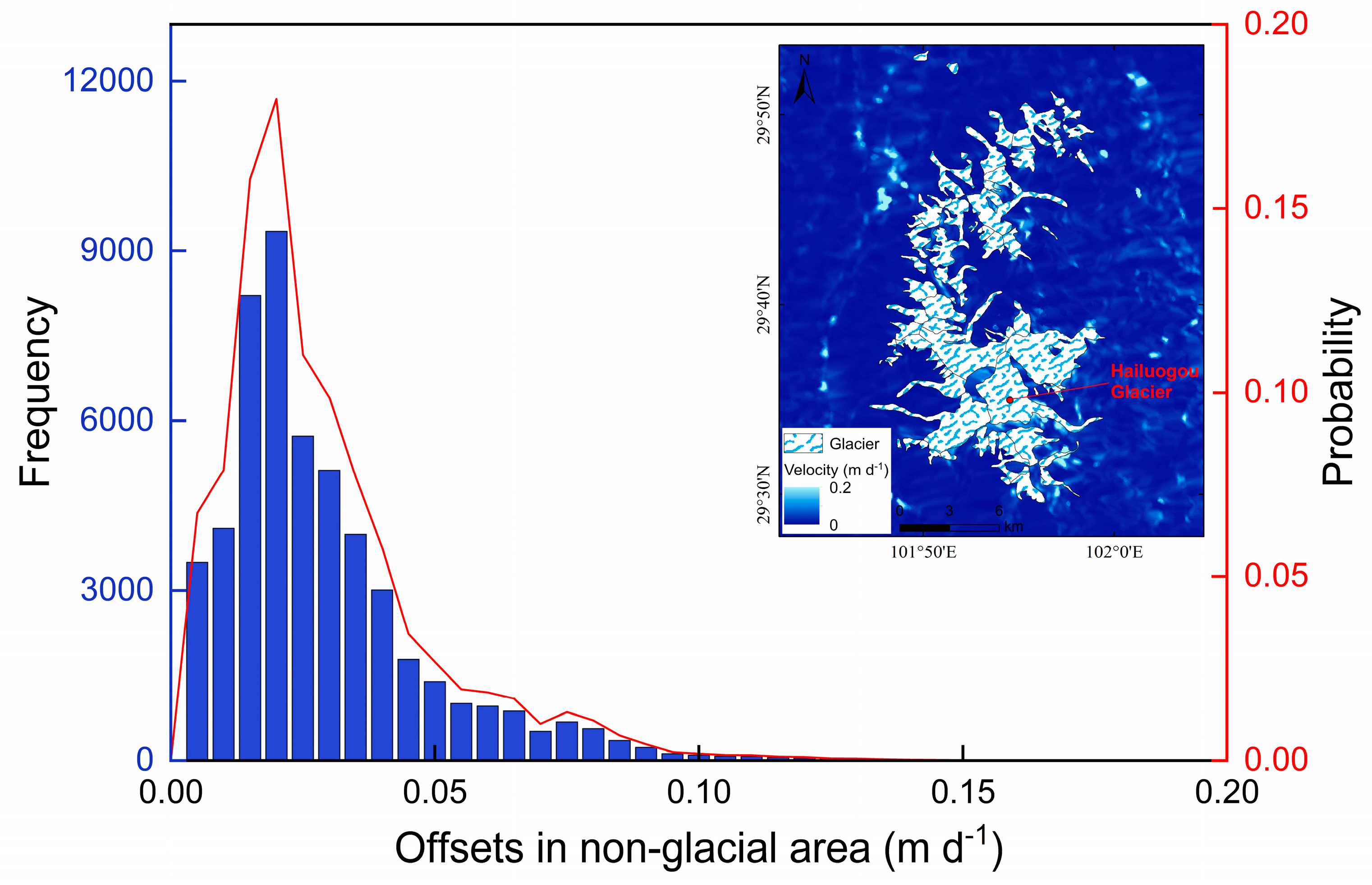
Uncertainty in velocity measurement by using the offset-tracking approach is evaluated by investigating final residual displacement of the non-glacier region. The error of the registration algorithm of the GAMMA software is controlled within 0.01 pixels, and the corresponding slant-range and azimuth offset estimation errors of Sentinel-1A image are 0.018 m and 0.009 m, respectively. The relative error is expressed by the absolute error divided by the observation period [58]. Then, an average uncertainty of surface velocity is about 0.011 m d−1, which can be negligible for the surface movement of maritime glaciers. Figure 2 shows offsets in non-glacier region, which indicates the stable variation. This confirms that the surface displacement estimates using the offset-tracking approach are robust.

3.2. Surface Energy–Mass Balance Model

To investigate the interdecadal variation in surface mass balance of HLG, we conducted a physically based energy–mass balance model to reconstruct HLG surface mass balance over the past 70 years. The model considers all components of the energy balance on different glacier surfaces (snow, debris-free, and debris-covered surfaces), which particularly accounts for the spatial pattern of supraglacial debris cover on the ablation zone and treatment processes occurring in the subsurface after meltwater percolates in the underlying layers [41]. For the model, we divide the glacier into a set of elevation bands at intervals of 50 m, in which glacier surface is classified into debris-free and debris-covered ice surfaces based on the spatial distribution of the thermal resistance of the debris layer. The value of debris thermal resistance greater than 0 indicates the debris-covered surface, while the value less than or equal to 0 indicates the debris-free surface.
The present model is forced with the best combination of the GAEORS observed and bias-corrected meteorological data from 1950 to 2020 to calculate the specific mass balance (the sum of snow accumulation, glacier melt, and refreezing) for each 50 m elevation band at a time step of one day. In the simulation, we use glacier outlines generated in 1966, 1975, 1994, 2007, and 2017 to account for temporal changes in glacier area. The areas of each elevation band over different periods are calculated from glacier outlines and SRTM DEM. More details on the surface energy–mass balance model and related parameters are presented in Supplementary Section S1.
Due to the lack of observed mass balance data for HLG, a multilayer procedure is used to validate the model results based on all available mass change datasets of the glacier. We first validate the model results against the estimated ten-year glacier mass balance. Then, the model results are compared to the estimated mean mass changes over different periods, during which our model calculates the mean mass balance corresponding to mass change periods. These datasets are completely independent from our model results. Although these datasets only cover a short-term time series of HLG mass change, this integrative cross-validation can allow us to evaluate the model’s ability to realistically capture the controlling processes of glacier mass budget.

4. Results

4.1. Glacier Surface Velocity during 2015–2019

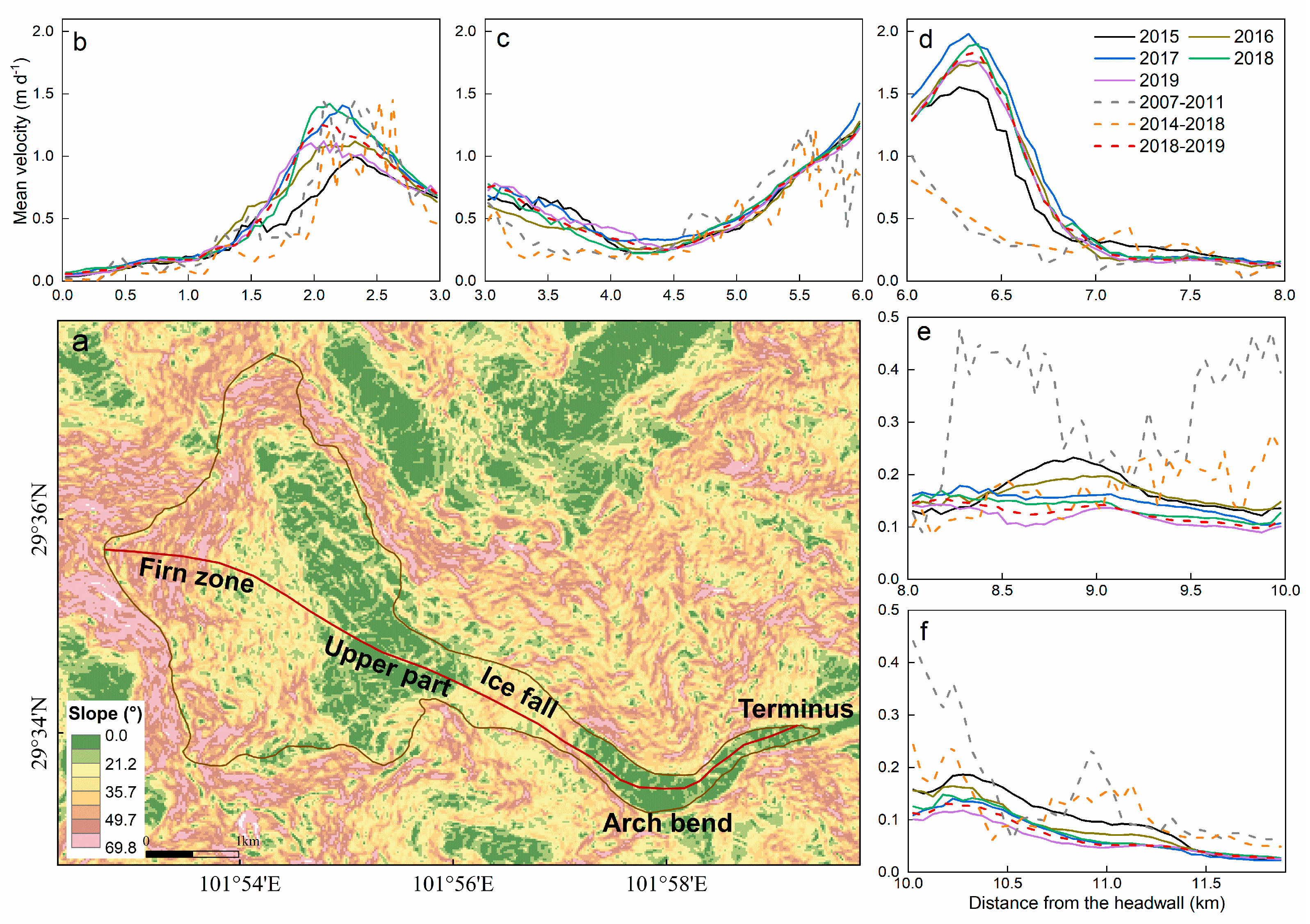
To investigate changes in HLG surface velocity, we divide the glacier into five parts along the central flow line according to glacier surface characteristics [7]. The five parts of the HLG are the firn zone, the upper part of the icefall, the icefall zone, the arch bend, and the terminus (Figure 3). Among the five parts (Figure 3a), the firn zone and the icefall zone are relatively steep, with slopes exceeding 30°, while the rest are relatively flat. Based on satellite-derived estimates from 2015 to 2019, we examine variations in the surface velocity for each part of the glacier. The average surface velocity along the glacier flow line was approximately 0.42 m d−1 during 2015–2019. The maximum surface velocity of the HLG is about 1.78 m d−1, which occurs in the icefall zone, while the minimum surface velocity is about 0.08 m d−1, which occurs at the glacier terminus.
Our results reveal significant spatial heterogeneity in glacier surface velocity, which exhibits a double-peak pattern (Figure 3 and Figure 4a). The surface velocity increases with the altitude from the glacier terminus and reaches the maximum in the icefall zone. Subsequently, the surface velocity gradually decreases in the upper part of the icefall and then increases with increasing altitude, and the second peak of the surface velocity appears in the firn zone (Figure 3). According to our average estimates during 2015–2019, it is found that the zones of the arch bend and the terminus experienced a pronounced slowdown overall, while a contrasting trend is observed in the firn zone, the upper part of the icefall, and the icefall zone. As shown in Figure 4b, the surface velocity of the HLG changes significantly with seasons. Glacier flow velocity in winter is slower compared with other seasons, with an average decrease of about 7.0–11.0%. The maximum flow velocity of the HLG is observed between May and June.

4.2. Multidecadal Changes in Glacier Surface Velocity

Analysis of glacier surface velocities during three periods of 2007–2011, 2014–2018, and 2018–2019 indicates that compared with the period 2007–2011, the overall surface velocity of the glacier decreased slightly during 2014–2018 and then increased during 2018–2019 (Figure 3). On average, glacier surface velocity increased slightly by approximately 11.3% in 2018–2019 compared to 2007–2011. This reveals that HLG surface movement has become relatively active in recent years, especially in the icefall zone and the area above it.
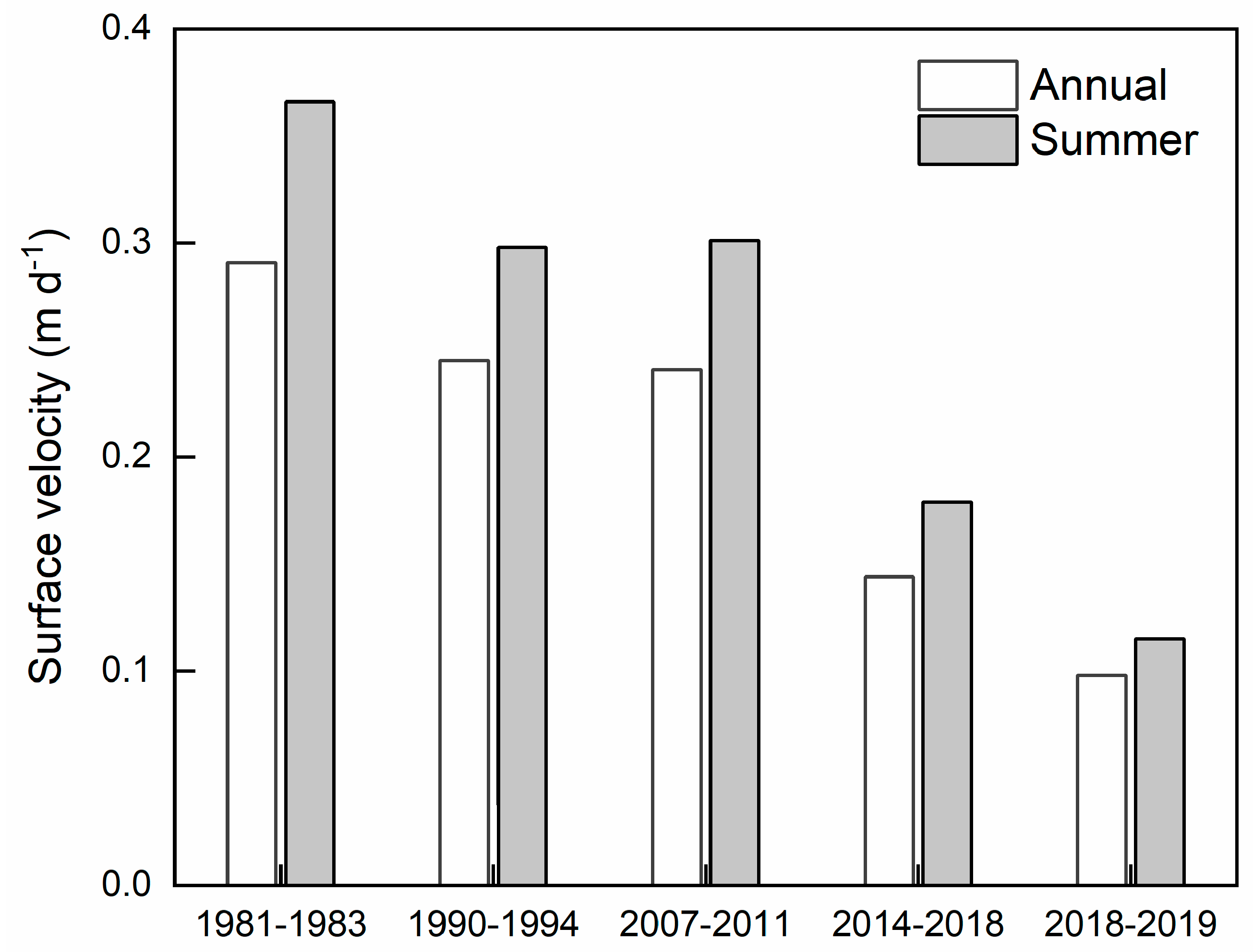
The results show that the largest surface velocity changes occur in the icefall zone for the period 2007–2019, followed by the zones of the arch bend and the terminus (Figure 3), while smaller surface velocity changes occur in the firn zone and the upper part of the icefall. Among the five parts of the glacier, the icefall zone, the upper part of the icefall, and the firn zone experienced speedup during 2007–2019, with a decrease in the speedup amplitude towards the high elevation zone. In particular, the surface velocity in the icefall zone during 2018–2019 has more than doubled compared to 2007–2011. In contrast, the zones of arch bend and glacier terminus, that is, the zone below the icefall, have experienced a steady and continuous slowdown since the 1980s (Figure 3 and Figure 5). A slight slowdown is observed in the zones below the icefall before 2010 (−5.7% decade−1), while a significant slowdown is observed after 2010 (−17.4% decade−1) (Figure 5). Likewise, summer surface velocity in the zones below the icefall was reduced by approximately 68.6% from 1981 to 2019 (Figure 5).

4.3. Multidecadal Glacier Mass Balance

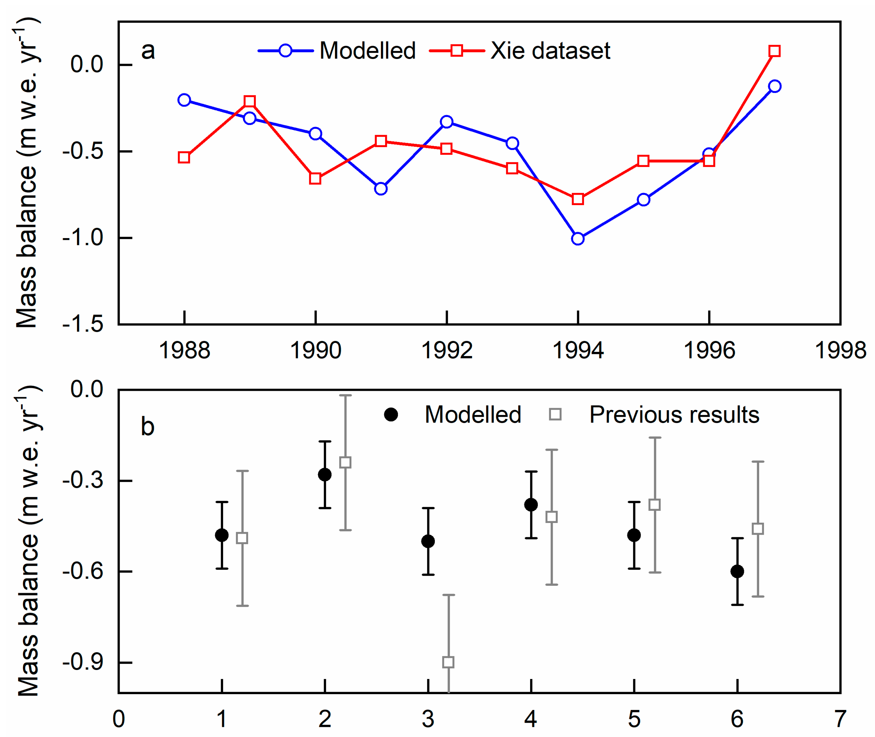
The time series of the HLG surface mass balance is calculated from 1950 to 2019 by combining observed and bias-corrected meteorological datasets. We first systematically evaluate the model results using available mass change datasets on HLG. A comparison between simulated glacier mass balance and previous mass balance estimates over the period 1988–1997 is shown in Figure 6a. Our results reveal close agreement with previous estimates during 1988–1997. The magnitude of the model results is consistent with the variation in previous estimates, which is very important, as the area-integrated glacier mass balance is the main focus of our study. Overall, the average modeled mass balance for the period 1988–1997 (−0.48 m w.e. year−1) shows an almost match with that of previous estimates (−0.47 m w.e. year−1). Figure 6b shows a comparison between our simulations and previous results estimated by different methods that are completely independent of our modeling approach. Our model results show a satisfactory fit with the results from these independent approaches over the corresponding period. The only discrepancy in Figure 6b indicates that the modeled glacier mass balance is more negative compared to the previous result. Overall, our modeling approach has a good capability to reproduce previous estimates. In particular, the results from different independent approaches show close agreement, providing confidence in applying the modeling approach to reconstruct the long time series of mass balance on HLG.
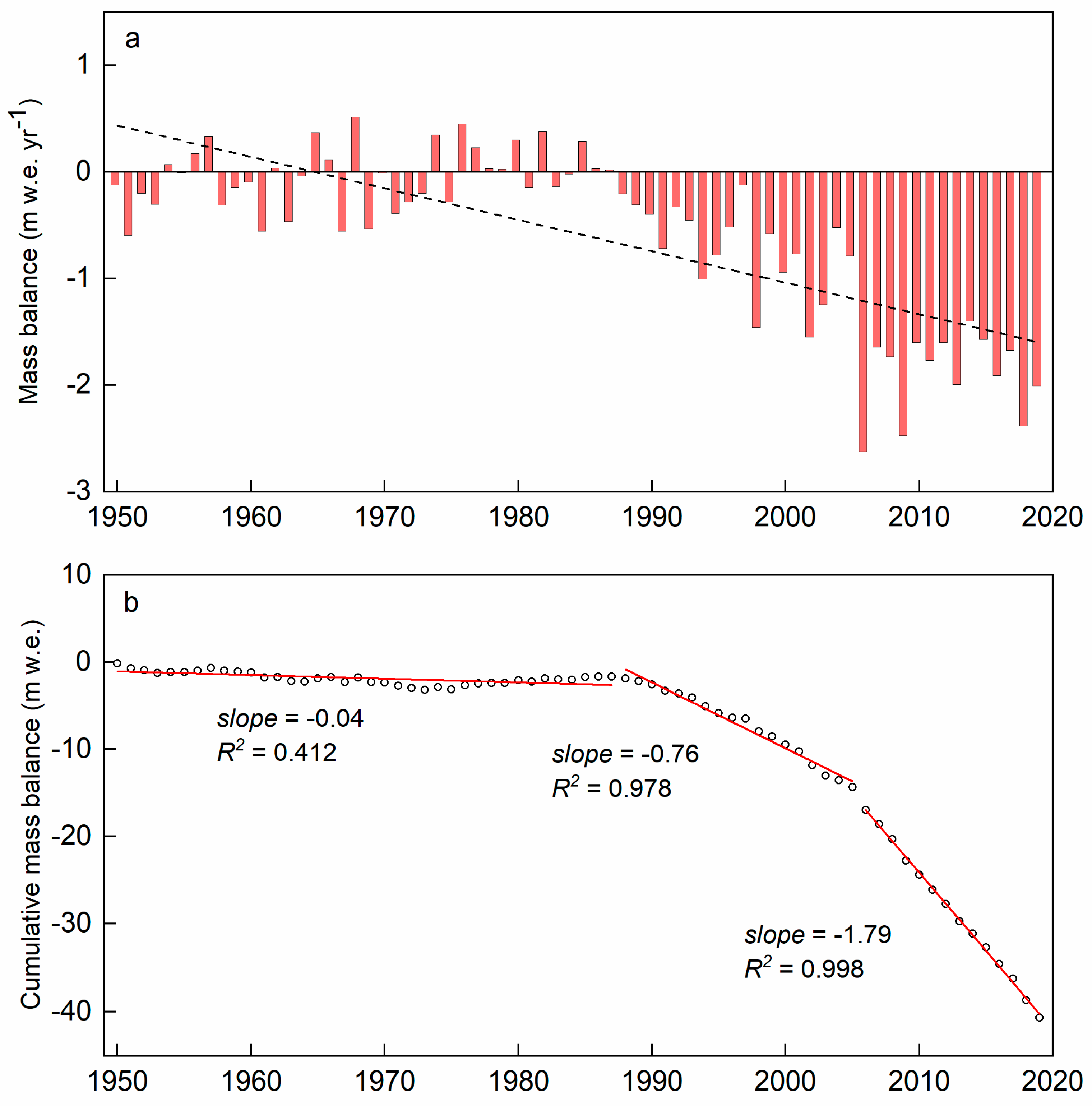
According to the HLG mass balance simulation, we find an imbalanced condition of the glacier for the period of 1950–2019 with a large interannual mass balance variation (Figure 7). The mean annual mass balance of the HLG is about −0.58 m w.e. year−1 during the past 70 years, of which about 80% years show a negative mass balance. During the study period, three distinct periods of the time series of the HLG mass balance are detected (Figure 7a). The glacier has a nearly balanced budget during the 1950–1987 period, with an average mass balance rate of −0.04 m w.e. year−1. The maximum positive mass balance (0.52 m w.e. year−1) is observed in the mass balance year of 1968. Then, glacier mass balance gradually becomes negative during the 1988–2005 period, with the mean mass balance of −0.70 m w.e. year−1. From 2006 onward, the mean annual glacier mass loss has intensified, and the average mass balance rate is about −1.88 m w.e. year−1, which is more than two times as much as the mean value over the period 1988–2005.
A similar variation in the cumulative glacier mass balance is observed for the study period (Figure 7b). The cumulative mass balance of the glacier is about −1.67 m w.e. for the period 1950–1987, which only represents about 4% of the total cumulative mass loss for the period 1950–2019. By contrast, about 65% of the total cumulative mass loss is observed during 2006–2019, especially in the recent decade (44%). This reveals that HLG has undergone largely accelerated mass loss since 2006 (Figure 7).

5. Discussion

5.1. HLG Status Revealed by Multidecadal Surface Velocity and Mass Balance

Glaciers in the southeastern TP have experienced considerably heterogeneous trends in surface velocity and mass change over the past decades [15,16,25,26,27]. Surface mass balance, the combination of mass gains and mass losses on the glacier, is most closely related to climate change [24], and its sensitivity combines with ice flow to cause glacier surface thinning or thickening. In particular, glacier surface velocity variation is strongly correlated with glacier-wide mass balance [26,31,59]. This indicates that changes in glacier velocity and mass balance can be used as the proxy for glacier status at multidecadal scales [24,26]. Therefore, knowledge of glacier surface velocity and mass balance is vital for understanding glacier status and associated drivers.
Our results show that HLG surface movement has become relatively active in recent years (Figure 3), especially in the icefall zone and the area above it. Based on the icefall zone, HLG surface movement is divided into two different trends during 2007–2019: significant speedup in the icefall zone and the area above it (39.1% decade−1) and sustained slowdown below the icefall zone (−44.1% decade−1). With the icefall zone and the area above it becoming quite active, a large amount of ice mass may move downglacier from the accumulation zone of the HLG. When the ice moves to the icefall zone, which is characterized by a steep surface (Figure 3a) and frequent avalanches [7], the glacier ice breaks and mixes again in this zone and then collapses at the foot of the icefall, which becomes a discontinuous part of the glacier [7]. As a result, the amount of ice mass transferred from the accumulation zone cannot fully move to the ablation zone. This process is completely different from other glaciers without icefall, where ice masses are directly transferred from the accumulation zone to the ablation zone to compensate for the ice loss caused by melting in this zone. This shows that the presence of the icefall with an altitude difference of more than 1000 m reduces the amount of ice mass transferring from the accumulation zone to the ablation zone, which cannot fully compensate for ice consumed by melting in this zone.
Based on model simulations reconstructing surface mass balance over the last 70 years, it is found that HLG has undergone a significant and continuous mass loss since the late 1980s (Figure 7). Ablation observations conducted in different periods confirm that the ice melt rate in the ablation zone has been increasing rapidly since the 1980s [17,31]. In particular, the inhomogeneous distribution of debris cover in most of the zone below the icefall strongly enhances mass loss and promotes the formation and development of ice cliffs, ice crevasses, and supraglacial ponds [8,11]. As glacier mass loss accelerates, surface runoff increases, and ice crevasses develop significantly, leading to more surface meltwater infiltrating into ice crevasses to reach the glacier base. As a result, the ice melting of both sides of ice crevasses is dramatically enhanced, and the crevasses open from top to bottom, which changes englacial and subglacial drainage systems and associated thermohydraulic properties [24]. Consequently, HLG becomes largely unstable overall, especially in the zone below the icefall, causing the glacier to retreat rapidly (Figure 1b). HLG terminus retreat has accelerated from 12.7 m year−1 during 1966–1989 to 27.4 m year−1 during 1998–2008 [48,55], especially between 2016 and 2020, when the terminus retreat exceeds approximately 54.0 m year−1 [49]. Analysis of the HLG surface velocity from 1981 to 2019 indicates that the zone below the icefall has experienced a sustained slowdown since the 1980s (Figure 5). On average, the surface velocity of this zone has been reduced by approximately 66.2% over the past nearly 40 years. It is noteworthy that changes in HLG surface velocity and mass loss have intensified since the late 2000s (Figure 5 and Figure 7). Consequently, enhanced mass loss and sustained slowdown drive accelerated surface thinning in the zone below the icefall. Using a geodetic method based on DEMs, it is estimated that the mean rate of surface elevation change in the zone below the icefall is about −0.67 m a−1 for the period 1966–1989, while the rate is about −1.61 m a−1 from 1989 onward [31,49]. Such a trend in accelerated surface thinning of the HLG has been observed during the last two decades [8,31,49], especially near the glacier terminus, where the maximum surface thinning rate reaches −2.2 m a−1 [49].
Apparently, sustained surface deceleration is concomitant with a marked mass loss on HLG, thereby affecting the redistribution of ice mass on the glacier. Especially the presence of the icefall gradually weakens the dynamic connection between accumulation and ablation zones of the HLG, significantly reducing the direct ice flux transport. These processes together markedly accelerate surface thinning and shrinkage of the HLG in recent decades.

5.2. HLG Sensitivity

As reported in recent studies [12,13,16,60], the average rate of mass loss for maritime glaciers is more than half a meter of water equivalent per year during the past two decades. Especially for the glaciers in the Hengduan Mountains of the southeastern TP, the mass loss rate is approximately −1.29 m w.e. year−1 over the period 2000–2019 [16]. In situ mass balance measurements on a glacier in Yulong Snow Mountain, located in the southwestern part of our study region, show a pronounced mass loss with a rate of −1.54 m w.e. year−1 for the period 2008–2020 [61]. HLG mass balance estimates indicate that the mass loss rate is approximately −1.60 m w.e. year−1 during 2000–2019, which is slightly negative compared to recently reported results in adjacent regions [2,10,16,60].
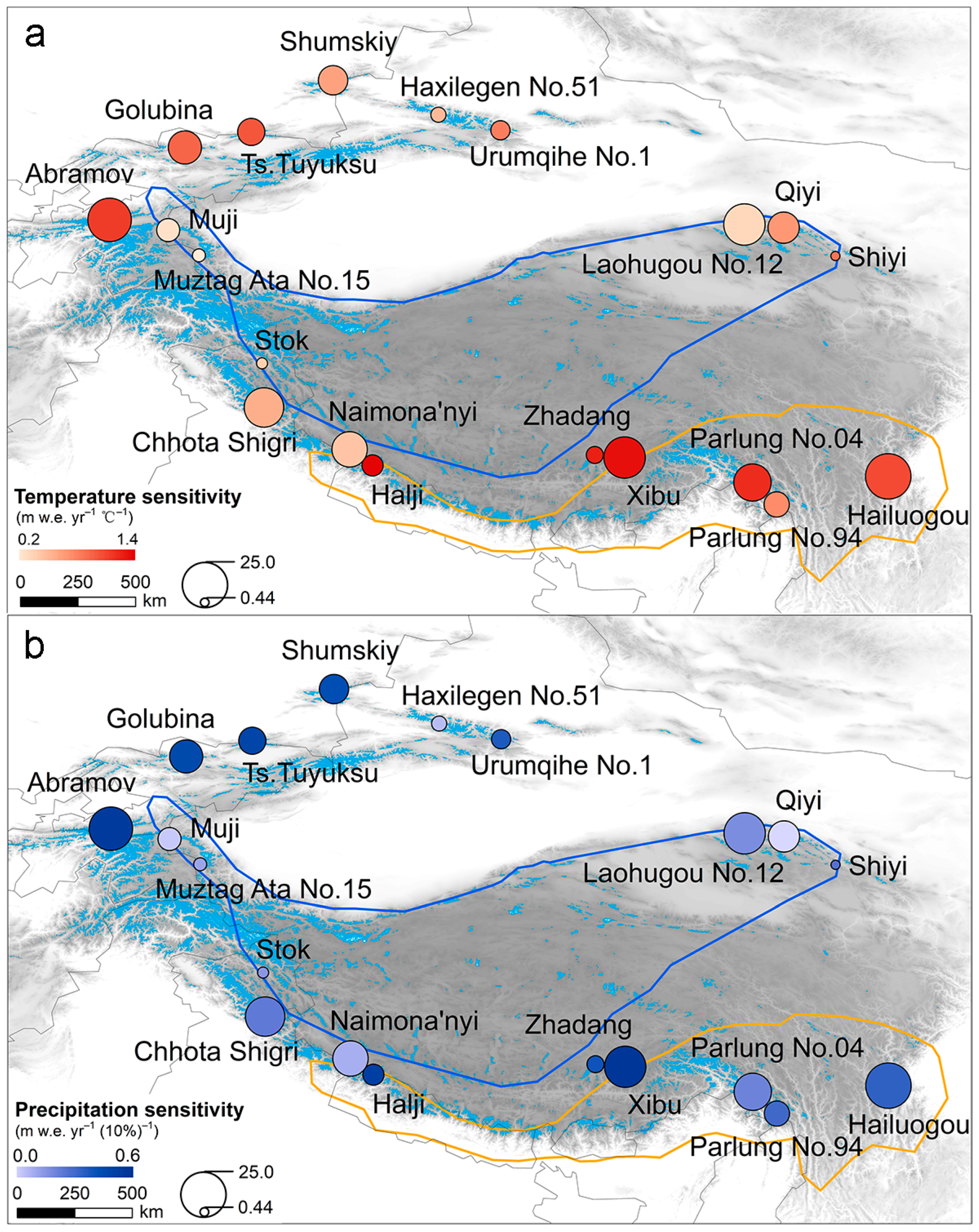
To investigate the climate sensitivity of the HLG, we conducted an experiment to estimate mass balance sensitivities to 1 °C temperature rise and a 10% precipitation increase, respectively, based on our modeling approach. The experiment results show that HLG mass balance sensitivity to a 1 °C-temperature rise is about −0.99 m w.e. year−1 °C−1, whereas the sensitivity to a 10% precipitation increase is about +0.22 m w.e. year−1 (10%)−1. Figure 8 shows the spatial pattern in mass balance sensitivities to temperature and precipitation changes for 19 glaciers covering major mountain ranges in the TP and surroundings, indicating a strong variability in glacier mass balance sensitivity. HLG mass balance sensitivity to temperature change is similar to other maritime glaciers and is significantly higher than those of subcontinental and extremely continental glaciers (Figure 8a). By contrast, the mass balance sensitivity of TP glaciers to precipitation change shows complicated variability (Figure 8b), varying between 0.03 m w.e. year−1 (10%)−1 and 0.55 m w.e. year−1 (10%)−1. HLG precipitation sensitivity is smaller than that of subcontinental glaciers and slightly higher than that of extremely continental glaciers (Figure 8b).
A comparison of relative differences in mass balance sensitivity confirms that HLG is most sensitive to temperature perturbations due to its active ice mass movement and high summer precipitation ratio [1,7,31]. Sensitivity experiments reveal that the increase in precipitation can compensate for the mass loss induced by temperature increases (approximately 22.2%), but a 10% change in precipitation is insufficient, which cannot fully offset the impact of a 1 °C temperature rise on the ablation and accumulation regimes of the HLG.

5.3. Potential Drivers of Multidecadal Change in HLG Mass Loss from Local to Macroscale

One of the remarkable features of the HLG is that the ablation zone is covered by extensive supraglacial debris cover, where debris thickness increases downglacier with considerable variability at each elevation [8,11]. The heterogeneous distribution of debris cover on the glacier strongly affects ice melting and its spatial pattern [8,11], as well as the formation and development of ice cliffs and supraglacial ponds in the ablation area [62]. For HLG, approximately 67.0% of the zone below the icefall has experienced accelerated melting compared to the climatically equivalent clean-ice surface, while approximately 19.0% has undergone suppressed melting [8]. An experiment on the glacier reveals that the ice melting from the debris-covered condition, especially the surface below 3600 m, is enhanced by 24.0% compared to that in the assumed no-debris surface in the ablation area [18]. Such an ice melting pattern leads to a reversed ablation gradient in the ablation area, thereby affecting the altitude structure of glacier mass balance [8,11]. More importantly, the spatial distribution of debris cover, especially the coexisting of thin debris, ice cliffs, and supraglacial ponds, markedly accelerates the mass loss of the HLG [8,11,41].
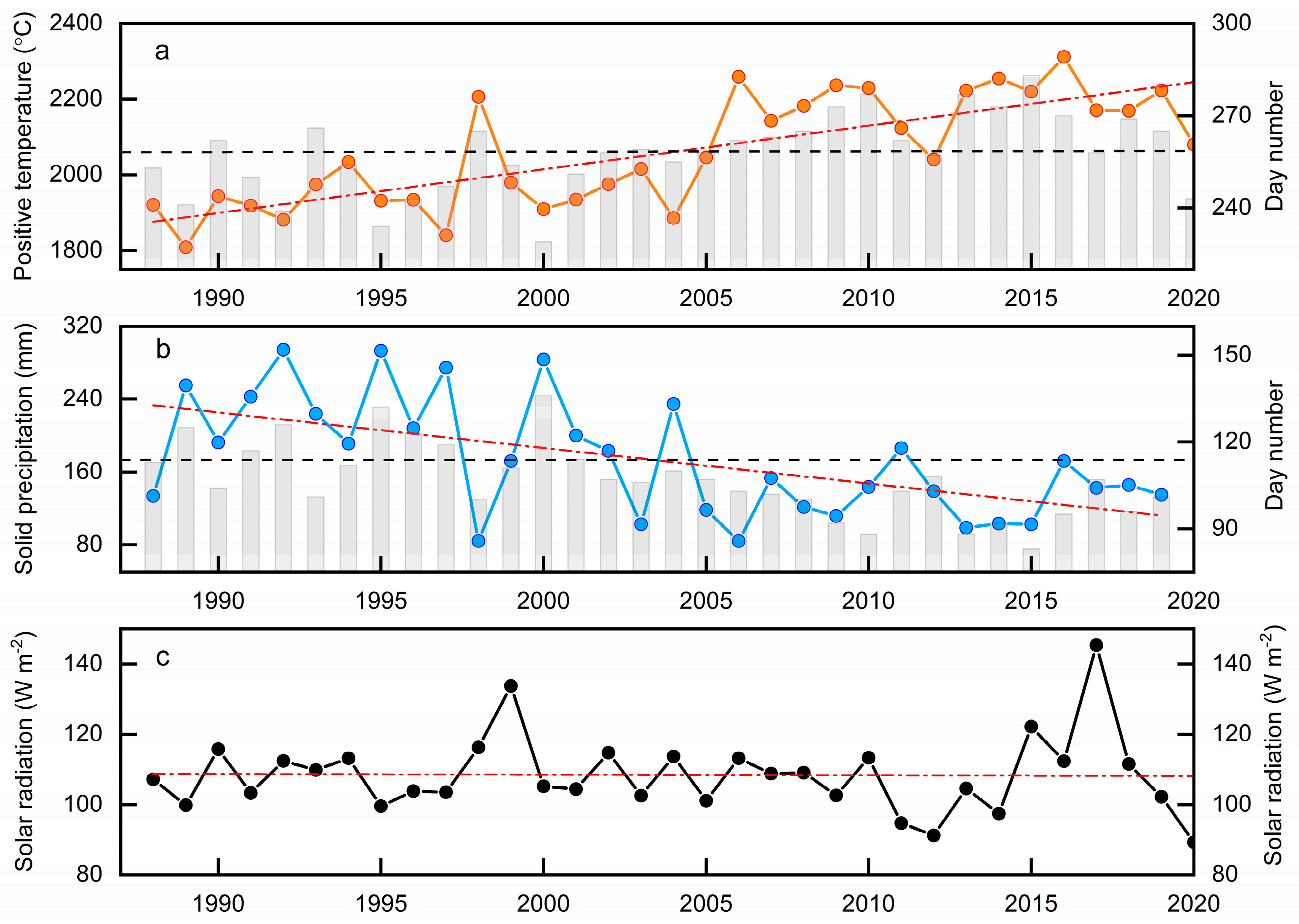
Besides the influence of debris cover on glacier mass loss, we focus on exploring the relationship between glacier mass balance and climate variables observed at the GAEORS near the glacier terminus for the period 1988–2020. It is certain that glacier ablation is strongly related to air temperature, which is generally expressed in the form of positive temperatures [63,64,65]. Thus, we calculate the positive air temperature sum using the temperature threshold of 0 °C for the period 1988–2020 (Figure 9), as well as solid precipitation (snowfall). Our analysis reveals that the annual mass balance of the HLG demonstrates a markedly negative correlation with the positive air temperature sum and a positive correlation with solid precipitation, yielding correlation coefficients of −0.87 and 0.67 (p < 0.001), respectively. According to GAEORS records, we find that the annual positive air temperature experiences a remarkable increasing trend with a rate of 12.5 °C year−1 over the period 1988–2020, and the days with the air temperature above 0 °C increase markedly (Figure 9a). The mean annual positive air temperature for the period 2006–2020 increased by 13.0% compared to that during 1988–2005, whereas the days with the air temperature above 0 °C increased by 7.0%. In particular, the mean positive air temperature in the cold season (November–April) during 2006–2020 increased by 36.2% compared to that during 1988–2005, while the days with the air temperature above 0 °C increased by 24.3%. This directly causes the ablation season to become longer and leads to a reduction of snow ratio through decreasing the precipitation falling as snow, which further reduces snow accumulation and surface albedo that enhances the absorption of solar radiation and ice melting. Figure 9b indicates that the annual solid precipitation shows a slightly decreasing trend with a rate of 3.9 mm year−1 for the period 1988–2020, and the days with solid precipitation decrease markedly, especially after 2005. The mean annual solid precipitation for the period 2006–2020 reduced by about 36.0% compared to that during 1988–2005, whereas the days with solid precipitation decreased by 18.0%. This trend is consistent with the snow depth variation in Mount Gongga reconstructed based on the subalpine tree-ring width and stable carbon isotope [66], which showed that extremely higher snow depth is observed during the period around 1990, and then snow depth gradually decreases in the following years.
Furthermore, the air temperature change strongly influences the longwave incoming radiation and sensible heat flux on the glacier [64]. Compared to longwave radiation, the influence of the air temperature on the sensible heat flux is slightly limited, and the sensible heat flux is less important, even in the ablation area [8,64,67]. Thus, the air temperature information is transferred to the glacier surface mainly via the incoming longwave radiation [64], which is the main energy source for glacier melting together with the shortwave radiation on HLG [7,8]. Observations at the GAEORS indicate that the shortwave radiation shows an insignificant fluctuation for the period 1988–2020 (Figure 9c). The mean annual shortwave radiation during the 2006–2020 period is no significant change compared to that during 1988–2005. Consequently, higher air temperature leads to a dramatic increase in the longwave incoming radiation and sensible heat flux on HLG for the period 2006–2020 compared to 1988–2005.
From the local perspective, the multidecadal change in mass loss of the HLG is mainly driven by the positive air temperature increase and snowfall decrease from 1988–2005 to 2006–2020, as well as the spatial distribution of debris cover. These processes on the glacier mentioned above, especially increased temperature, profoundly influence surface albedo, the longwave incoming radiation, and sensible heat flux, causing ablation acceleration and accumulation reduction, which is the primary reason for the higher negative mass balance on HLG over the period 2006–2019 compared to that during 1988–2005.
Previous studies have found that large-scale atmospheric circulation patterns have an important influence on TP glacier mass change [10,42,68,69,70]. However, our knowledge of the link between HLG mass balance and atmospheric circulation patterns is poor. Here, we calculate the differences in circulation patterns (geopotential height and wind fields at 500 hPa levels) between the periods of 1988–2005 and 2006–2019 during the monsoonal season (June–September) to investigate the influence of large-scale atmospheric circulations on interannual variation in HLG mass balance. Figure 10 shows a zonal wavy variation in the 500 hPa geopotential height and wind fields extended from Europe to Asia. Compared to 1988–2005, the 500 hPa geopotential height increases markedly in Europe and northern Asia for 2006–2019, while it shows a decreasing trend in northern Africa and southwestern and southern Asia. In the TP and surroundings, the eastern part is characterized by the positive geopotential height anomaly, while the negative geopotential height anomaly is observed in the western part. Meanwhile, the anticyclonic circulation is observed in central Europe and northern Asia, while the cyclonic circulation occurs in north Africa and southwest Asia (Figure 10).
Such atmospheric circulation patterns can transfer the perturbation energy from Europe to eastern Asia, which is associated with the jet stream [10,42,68,69]. In this vein, it may play an important role in regional temperature and precipitation variations in the southeastern TP. Previous studies underlined that as the distance from the center of a cyclonic anomaly in the east over central Asia increases, where the southerlies encounter the expansion zone of southern Asia. High, warm-air advection favors regional warming across the eastern TP [69,71]. Meanwhile, an anticyclonic circulation is formed in southern Asia, which, coupled with weakened southwesterlies, is not conducive to the delivery of water vapor flux into the southeastern TP, with important consequences for regional precipitation decreasing [10]. Under spatial patterns of atmospheric circulation (Figure 10), the seasonal variation in the air temperature observed at the terminus of the HLG indicates that the mean air temperature of all months in 2006–2020 is significantly higher than that in 1988–2005 (Supplementary Figure S1a). On the other hand, the monthly precipitation in the monsoonal season during the same period decreases considerably (Supplementary Figure S1b). Our findings are in agreement with previous studies, which revealed that atmospheric circulation patterns with an anticyclonic anomaly across Europe and a cyclonic anomaly across Asia lead to temperature increasing in the eastern TP [42,69,70] and precipitation decreasing in the southeastern TP [10].

5.4. Implications for Water Supply and Glacier-Related Hazards

Our satellite-based results reveal that the icefall zone and the area above it have become quite active, especially in the icefall zone, which experienced significant speedup during 2007–2019. As a result, the frequency of ice/snow avalanches has increased significantly in recent years. This phenomenon has been observed on different glaciers in the southeastern TP [43,48]. Previous studies indicate that river runoff observed near the HLG terminus shows a consistent trend with reconstructed glacier runoff during the past three decades [17,18]. Variation in glacier runoff principally depends on changes in glacier mass change and the associated response to ongoing warming [24]. Our results show that HLG has experienced a continuously negative mass balance since the late 1980s, especially from 2006 onward, in which the mean annual glacier mass loss has intensified. This implies that as HLG mass loss accelerates, the glacier releases much more water from long-term storage, thereby contributing to river runoff increasing and affecting its seasonality and magnitude. Therefore, future development of planned hydropower and water diversion projects in this region should carefully consider both hazards and changing water resources.

6. Conclusions

We investigate the trends in surface velocity and mass balance of the HLG in the southeast TP during the past several decades and explore possible causes of glacier mass dynamic change. Our results find that HLG surface velocity shows considerable spatial heterogeneity between 2015 and 2019, with complicated seasonal and interannual variability, especially in the zone below the icefall, where surface velocity has experienced a sustained slowdown over the past nearly 40 years, with an average deceleration of 66.2% compared to in situ observations in 1981–1983. Our modeling demonstrates an overall downward trend in glacier mass balance over the period 1950–2019 and an accelerating mass loss trend with a mean rate of −1.60 m w.e. year−1 in the past two decades.
In addition to the influence of debris cover, the dramatic negative mass balance of the HLG is primarily related to the positive air temperature increase, which causes ablation acceleration and accumulation reduction by affecting the longwave incoming radiation, surface albedo, and snowfall ratio. Also, we find that such interannual changes in glacier mass balance have a close connection with large-scale atmospheric circulation patterns in the Eurasian region by influencing regional-to-local climate variability. These spatiotemporal characteristics of glacier mass and dynamic changes will be valuable for understanding the maritime glacier response to environmental forces and assessing water supply and glacier-related hazards in the southeastern TP, as well as their linkages with local and remote drivers.

Supplementary Materials

The following supporting information can be downloaded at: https://www.mdpi.com/article/10.3390/rs16030571/s1, Figure S1: Monthly mean air temperature (a) and precipitation (b) observed at the GAEORS near the glacier terminus for the periods 1988–2005 and 2006–2020; Table S1: Overview of satellite images used for glacier surface velocity; Table S2: Mass balance sensitivity to 1 °C temperature rise (m w.e. °C−1) and 10% precipitation increase (m w.e. (10%)−1) of different glaciers across the Tibetan Plateau [72,73,74,75,76,77,78,79,80,81,82,83,84,85,86,87,88]. Section S1: Surface energy-mass balance model.

Author Contributions

Conceptualization, Y.Z.; methodology, Y.Z.; software, X.L., Z.J. and X.W.; validation, H.W.; formal analysis, Y.Z.; investigation, J.G.; data curation, J.G.; writing—original draft preparation, Y.Z. and J.G.; writing—review and editing, Y.Z.; visualization, J.W.; supervision, H.W.; project administration, X.L., Z.J. and X.W.; funding acquisition, Y.Z. All authors have read and agreed to the published version of the manuscript.

Funding

This research was supported by the National Natural Science Foundation of China (Grant Nos. 42171134, 41671057, and 41761144075) and the Natural Science Foundation of Hunan Province (Grant No. 2021JJ30247).

Data Availability Statement

Data will be made available on request.

Acknowledgments

We acknowledge the Gongga Alpine Ecosystem Observation and Research Station of the Chinese Ecological Research Network for providing meteorological data and the ESA for providing Sentinel-1A data.

Conflicts of Interest

The authors declare no conflicts of interest.

References

  1. Shi, Y.; Liu, S. Estimation on the response of glaciers in China to the global warming in the 21st century. Chin. Sci. Bull. 2000, 45, 668–672. [Google Scholar] [CrossRef]
  2. Yao, T.; Thompson, L.; Yang, W.; Yu, W.; Gao, Y.; Guo, X.; Yang, X.; Duan, K.; Zhao, H.; Xu, B.; et al. Different glacier status with atmospheric circulations in Tibetan Plateau and surroundings. Nat. Clim. Chang. 2012, 2, 663–667. [Google Scholar] [CrossRef]
  3. Zhang, Y.; Enomoto, H.; Ohata, T.; Kitabata, H.; Kadota, T.; Hirabayashi, Y. Glacier mass balance and its potential impacts in the Altai Mountains over the period 1990–2011. J. Hydrol. 2017, 553, 662–677. [Google Scholar] [CrossRef]
  4. Pritchard, H.D. Asia’s shrinking glaciers protect large populations from drought stress. Nature 2019, 569, 649–654. [Google Scholar] [CrossRef]
  5. Immerzeel, W.W.; Lutz, A.; Andrade, M.; Bahl, A.; Biemans, H.; Bolch, T.; Hyde, S.; Brumby, S.; Davies, B.; Elmore, A. Importance and vulnerability of the world’s water towers. Nature 2020, 577, 364–369. [Google Scholar] [CrossRef]
  6. Azam, M.F.; Kargel, J.S.; Shea, J.M.; Nepal, S.; Haritashya, U.K.; Srivastava, S.; Maussion, F.; Qazi, N.; Chevallier, P.; Dimri, A. Glaciohydrology of the himalaya-karakoram. Science 2021, 373, eabf3668. [Google Scholar] [CrossRef]
  7. Li, J.; Su, Z. Glaciers in the Hengduan Mountains; Science Press: Beijing, China, 1996. (In Chinese) [Google Scholar]
  8. Zhang, Y.; Fujita, K.; Liu, S.; Liu, Q.; Nuimura, T. Distribution of debris thickness and its effect on ice melt at Hailuogou glacier, southeastern Tibetan Plateau, using in situ surveys and ASTER imagery. J. Glaciol. 2011, 57, 1147–1157. [Google Scholar] [CrossRef]
  9. Yang, W.; Yao, T.; Guo, X.; Zhu, M.; Li, S.; Kattel, D.B. Mass balance of a maritime glacier on the southeast Tibetan Plateau and its climatic sensitivity. J. Geophys. Res. Atmos. 2013, 118, 9579–9594. [Google Scholar] [CrossRef]
  10. Yang, W.; Guo, X.; Yao, T.; Zhu, M.; Wang, Y. Recent accelerating mass loss of southeast Tibetan glaciers and the relationship with changes in macroscale atmospheric circulations. Clim. Dyn. 2016, 47, 805–815. [Google Scholar] [CrossRef]
  11. Zhang, Y.; Hirabayashi, Y.; Fujita, K.; Liu, S.; Liu, Q. Heterogeneity in supraglacial debris thickness and its role in glacier mass changes of the Mount Gongga. Sci. China Earth Sci. 2016, 59, 170–184. [Google Scholar] [CrossRef]
  12. Brun, F.; Berthier, E.; Wagnon, P.; Kääb, A.; Treichler, D. A spatially resolved estimate of High Mountain Asia glacier mass balances from 2000 to 2016. Nat. Geosci. 2017, 10, 668–673. [Google Scholar] [CrossRef] [PubMed]
  13. Shean, D.E.; Bhushan, S.; Montesano, P.; Rounce, D.R.; Arendt, A.; Osmanoglu, B. A systematic, regional assessment of high mountain Asia glacier mass balance. Front. Earth Sci. 2020, 7, 363. [Google Scholar] [CrossRef]
  14. Jakob, L.; Gourmelen, N.; Ewart, M.; Plummer, S. Spatially and temporally resolved ice loss in High Mountain Asia and the Gulf of Alaska observed by CryoSat-2 swath altimetry between 2010 and 2019. Cryosphere 2021, 15, 1845–1862. [Google Scholar] [CrossRef]
  15. Miles, E.; Mccarthy, M.; Dehecq, A.; Kneib, M.; Fugger, S.; Pellicciotti, F. Health and sustainability of glaciers in High Mountain Asia. Nat. Commun. 2021, 12, 2868. [Google Scholar] [CrossRef] [PubMed]
  16. Zhao, F.; Long, D.; Li, X.; Huang, Q.; Han, P. Rapid glacier mass loss in the Southeastern Tibetan Plateau since the year 2000 from satellite observations. Remote Sens. Environ 2022, 270, 112853. [Google Scholar] [CrossRef]
  17. Zhang, Y.; Hirabayashi, Y.; Liu, Q.; Liu, S. Glacier runoff and its impact in a highly glacierized catchment in the southeastern Tibetan Plateau: Past and future trends. J. Glaciol. 2015, 61, 713–730. [Google Scholar] [CrossRef]
  18. Zhang, Y.; Liu, S.; Liu, Q.; Wang, X.; Jiang, Z.; Wei, J. The role of debris covers in catchment runoff: A case study of the Hailuogou catchment, south-eastern Tibetan plateau. Water 2019, 11, 2601. [Google Scholar] [CrossRef]
  19. Yi, S.; Song, C.; Heki, K.; Kang, S.; Wang, Q.; Chang, L. Satellite-observed monthly glacier and snow mass changes in southeast Tibet: Implication for substantial meltwater contribution to the Brahmaputra. Cryosphere 2020, 14, 2267–2281. [Google Scholar] [CrossRef]
  20. Liu, J.; Zhang, J.; Gao, B.; Li, Y.; Li, M.; Wu, J.D.; Zhou, L. An overview of glacial lake outburst flood in Tibet, China. J. Glaciol. Geocryol. 2019, 41, 1335–1347. [Google Scholar]
  21. Chen, C.; Zhang, L.; Xiao, T.; He, J. Barrier Lake bursting and flood routing in the Yarlung Tsangpo Grand Canyon in October 2018. J. Hydrol. 2020, 583, 124603. [Google Scholar] [CrossRef]
  22. An, B.; Wang, W.; Yang, W.; Wu, G.; Guo, Y.; Zhu, H.; Gao, Y.; Bai, L.; Zhang, F.; Zeng, C. Process, mechanisms, and early warning of glacier collapse-induced river blocking disasters in the Yarlung Tsangpo Grand Canyon, southeastern Tibetan Plateau. Sci. Total Environ. 2022, 816, 151652. [Google Scholar] [CrossRef] [PubMed]
  23. Ding, Y.; Mu, C.; Wu, T.; Hu, G.; Zou, D.; Wang, D.; Li, W.; Wu, X. Increasing cryospheric hazards in a warming climate. Earth Sci. Rev. 2021, 213, 103500. [Google Scholar] [CrossRef]
  24. Cuffey, K.M.; Paterson, W.S.B. The Physics of Glaciers; Academic Press: Cambridge, MA, USA, 2010. [Google Scholar]
  25. Neckel, N.; Loibl, D.; Rankl, M. Recent slowdown and thinning of debris-covered glaciers in south-eastern Tibet. Earth Planet Sci. Lett. 2017, 464, 95–102. [Google Scholar] [CrossRef]
  26. Dehecq, A.; Gourmelen, N.; Gardner, A.S.; Brun, F.; Goldberg, D.; Nienow, P.W.; Berthier, E.; Vincent, C.; Wagnon, P.; Trouvé, E. Twenty-first century glacier slowdown driven by mass loss in High Mountain Asia. Nat. Geosci. 2019, 12, 22–27. [Google Scholar] [CrossRef]
  27. Wu, K.; Liu, S.; Zhu, Y.; Liu, Q.; Jiang, Z. Dynamics of glacier surface velocity and ice thickness for maritime glaciers in the southeastern Tibetan Plateau. J. Hydrol. 2020, 590, 125527. [Google Scholar] [CrossRef]
  28. Fan, J.; An, C.; Zhang, X.; Li, X.; Tan, J. Hazard assessment of glacial lake outburst floods in Southeast Tibet based on RS and GIS technologies. Int. J. Remote Sens. 2019, 40, 4955–4979. [Google Scholar] [CrossRef]
  29. Kääb, A.; Leinss, S.; Gilbert, A.; Bühler, Y.; Gascoin, S.; Evans, S.G.; Bartelt, P.; Berthier, E.; Brun, F.; Chao, W.A. Massive collapse of two glaciers in western Tibet in 2016 after surge-like instability. Nat. Geosci. 2018, 11, 114–120. [Google Scholar] [CrossRef]
  30. Veh, G.; Korup, O.; von Specht, S.; Roessner, S.; Walz, A. Unchanged frequency of moraine-dammed glacial lake outburst floods in the Himalaya. Nat. Clim. Chang. 2019, 9, 379–383. [Google Scholar] [CrossRef]
  31. Zhang, Y.; Fujita, K.; Liu, S.; Liu, Q.; Wang, X. Multi-decadal ice-velocity and elevation changes of a monsoonal maritime glacier: Hailuogou glacier, China. J. Glaciol. 2010, 56, 65–74. [Google Scholar] [CrossRef]
  32. Yan, S.; Li, Y.; Ruan, Z.; Lv, M.; Liu, G.; Deng, K. Wavelet-Based Topographic Effect Compensation in Accurate Mountain Glacier Velocity Extraction: A Case Study of the Muztagh Ata Region, Eastern Pamir. Remote Sens. 2017, 9, 697. [Google Scholar] [CrossRef]
  33. Guan, Y.; Cui, W.; Liu, J.; Lu, H.; Jiang, Y.; Xue, Y.; Heiskanen, J. Observed Changes of Köppen Climate Zones Based on High-Resolution Data Sets in the Qinghai-Tibet Plateau. Geophys. Res. Lett. 2021, 48, e2021GL096159. [Google Scholar] [CrossRef]
  34. Mohr, J.J.; Reeh, N.; Madsen, S.N. Three-dimensional glacial flow and surface elevation measured with radar interferometry. Nature 1998, 391, 273–276. [Google Scholar] [CrossRef]
  35. Rignot, E. Mass balance of East Antarctic glaciers and ice shelves from satellite data. Ann. Glaciol. 2002, 34, 217–227. [Google Scholar] [CrossRef]
  36. Huang, L.; Li, Z.; Zhou, J.; Tian, B. Glacier Change Monitoring Using SAR: An Overview. Sci. China Earth Sci. 2014, 29, 985–994, (In Chinese with English Abstract). [Google Scholar]
  37. Satyabala, S. Spatiotemporal variations in surface velocity of the Gangotri glacier, Garhwal Himalaya, India: Study using synthetic aperture radar data. Remote Sens. Environ. 2016, 181, 151–161. [Google Scholar] [CrossRef]
  38. Rignot, E.; Echelmeyer, K.; Krabill, W. Penetration depth of interferometric synthetic-aperture radar signals in snow and ice. Geophys. Res. Lett. 2001, 28, 3501–3504. [Google Scholar] [CrossRef]
  39. Fallourd, R.; Harant, O.; Trouvé, E.; Nicolas, J.M.; Gay, M.; Walpersdorf, A.; Mugnier, J.L.; Serafini, J.; Rosu, D.; Bombrun, L. Monitoring temperate glacier displacement by multi-temporal TerraSAR-X images and continuous GPS measurements. IEEE J. Sel. Top. Appl. Earth Obs. Remote Sens. 2011, 4, 372–386. [Google Scholar] [CrossRef]
  40. Jiang, Z.; Wu, K.; Liu, S.; Wang, X.; Zhang, Y.; Tahir, A.A.; Long, S. Surging dynamics of South Rimo Glacier, Eastern Karakoram. Environ. Res. Lett. 2021, 16, 114044. [Google Scholar] [CrossRef]
  41. Zhang, Y.; Hirabayashi, Y.; Liu, S. Catchment-scale reconstruction of glacier mass balance using observations and global climate data: Case study of the Hailuogou catchment, south-eastern Tibetan Plateau. J. Hydrol. 2012, 444–445, 146–160. [Google Scholar] [CrossRef]
  42. Zhu, M.; Yao, T.; Yang, W.; Xu, B.; Wu, G.; Wang, X. Differences in mass balance behavior for three glaciers from different climatic regions on the Tibetan Plateau. Clim. Dyn. 2018, 50, 3457–3484. [Google Scholar] [CrossRef]
  43. Jouberton, A.; Shaw, T.E.; Miles, E.; McCarthy, M.; Fugger, S.; Ren, S.; Dehecq, A.; Yang, W.; Pellicciotti, F. Warming-induced monsoon precipitation phase change intensifies glacier mass loss in the southeastern Tibetan Plateau. Proc. Natl. Acad. Sci. USA 2022, 119, e2109796119. [Google Scholar] [CrossRef]
  44. Su, Z.; Song, G.; Cao, Z. Maritime characteristics of Hailuogou glacier in the Gongga Mountains. J. Glaciol. Geocryol. 1996, 18, 51–59, (In Chinese with English Summary). [Google Scholar]
  45. Liu, G.; Zhang, B.; Zhang, R.; Cai, J.; Fu, Y.; Liu, Q.; Yu, B.; Li, Z. Monitoring Dynamics of Hailuogou Glacier and the Secondary Landslide Disasters Based on Combination of Satellite SAR and Ground-Based SAR. Geo. Inf. Sci. Wuhan Univ. 2019, 44, 980–995, (In Chinese with English Abstract). [Google Scholar]
  46. Hirabayashi, Y.; Kanae, S.; Motoya, K.; Masuda, K.; Döll, P. A 59-year (1948–2006) global near-surface meteorological data set for land surface models. Part I: Development of daily forcing and assessment of precipitation intensity. Hydrol. Res. Lett. 2008, 2, 36–40. [Google Scholar] [CrossRef]
  47. Yatagai, A.; Arakawa, O.; Kamiguchi, K.; Kawamoto, H.; Nodzu, M.I.; Hamada, A. A 44-year daily gridded precipitation dataset for Asia based on a dense network of rain gauges. Sola 2009, 5, 137–140. [Google Scholar] [CrossRef]
  48. Liu, Q.; Liu, S.; Zhang, Y.; Wang, X.; Zhang, Y.; Guo, W.; Xu, J. Recent shrinkage and hydrological response of Hailuogou glacier, a monsoon temperate glacier on the east slope of Mount Gongga, China. J. Glaciol. 2010, 56, 215–224. [Google Scholar] [CrossRef]
  49. Zhong, Y.; Liu, Q.; Westoby, M.; Nie, Y.; Pellicciotti, F.; Zhang, B.; Cai, J.; Liu, G.; Liao, H.; Lu, X. Intensified paraglacial slope failures due to accelerating downwasting of a temperate glacier in Mt. Gongga, southeastern Tibetan Plateau. Earth Surf. Dyn. 2022, 10, 23–42. [Google Scholar] [CrossRef]
  50. Farr, T.G.; Rosen, P.A.; Caro, E.; Crippen, R.; Duren, R.; Hensley, S.; Kobrick, M.; Paller, M.; Rodriguez, E.; Roth, L. The shuttle radar topography mission. Rev. Geophys. 2007, 45, RG2004. [Google Scholar] [CrossRef]
  51. Xie, Z.; Su, Z.; Shen, Y.; Feng, Q. Mass balance and water exchange of Hailuoguo glacier in Mount Gongga and their influence on glacial melt runoff. J. Glaciol. Geocryol. 2001, 23, 7–15, (In Chinese with English Abstract). [Google Scholar]
  52. Xie, Z.; Su, Z.; Cao, Z. Water and mass balance in the Gongga mountain. In Researches on Evolution, Environment Change and Ecosystems of Tibet Plateau; Expert Committee on Qinghai-Xizang Project, Ed.; Science Press: Beijing, China, 1995; pp. 340–346. (In Chinese) [Google Scholar]
  53. Li, Z.; He, Y.; Jia, W.; Pang, H.; He, X.; Wang, S.; Zhang, N.; Zhang, W.; Liu, Q.; Xin, H. Changes in Hailuogou Glacier during the recent 100 years under global warming. J. Glaciol. Geocryol. 2009, 31, 75–81, (In Chinese with English Abstract). [Google Scholar]
  54. Li, Z.; He, Y.; Pu, T.; Jia, W.; He, X.; Pang, H.; Zhang, N.; Liu, Q.; Wang, S.; Zhu, G.; et al. Changes of climate, glaciers and runoff in China’s monsoonal temperate glacier region during the last several decades. Quat. Int. 2010, 218, 13–28. [Google Scholar]
  55. Zhang, G.; Pan, B.; Cao, B.; Wang, J.; Cui, H.; Cao, X. Elevation changes measured during 1966–2010 on the monsoonal temperate glaciers’ ablation region, Gongga Mountains, China. Quat. Int. 2015, 371, 49–57. [Google Scholar] [CrossRef]
  56. Cao, B.; Pan, B.; Guan, W.; Wen, Z.; Wang, J. Changes in glacier volume on Mt. Gongga, southeastern Tibetan Plateau, based on the analysis of multi-temporal DEMs from 1966 to 2015. J. Glaciol. 2019, 65, 366–375. [Google Scholar] [CrossRef]
  57. Hoffmann, L.; Günther, G.; Li, D.; Stein, O.; Wu, X.; Griessbach, S.; Heng, Y.; Konopka, P.; Müller, R.; Vogel, B. From ERA-Interim to ERA5: The considerable impact of ECMWF’s next-generation reanalysis on Lagrangian transport simulations. Atmos. Chem. Phys. 2019, 19, 3097–3124. [Google Scholar] [CrossRef]
  58. Strozzi, T.; Luckman, A.; Murray, T.; Wegmuller, U.; Werner, C.L. Glacier motion estimation using SAR offset-tracking procedures. IEEE Trans. Geosci. Remote Sens. 2002, 40, 2384–2391. [Google Scholar] [CrossRef]
  59. Zhou, Y.; Chen, J.; Cheng, X. Glacier Velocity Changes in the Himalayas in Relation to Ice Mass Balance. Remote Sens. 2021, 13, 3825. [Google Scholar] [CrossRef]
  60. Yan, X.; Ma, J.; Ma, X.; Wang, S.; Chen, P.; He, Y. Accelerated glacier mass loss with atmospheric changes on Mt. Yulong, Southeastern Tibetan Plateau. J. Hydrol. 2021, 603, 126931. [Google Scholar] [CrossRef]
  61. Shi, Y.; Liu, C.; Wang, Z.; Liu, S.; Ye, B. A Concise China Glacier Inventory; Shanghai Science Popularization Press: Shanghai, China, 2005. (In Chinese) [Google Scholar]
  62. Benn, D.I.; Bolch, T.; Hands, K.; Gulley, J.; Luckman, A.; Nicholson, L.I.; Quincey, D.; Thompson, S.; Toumi, R.; Wiseman, S. Response of debris-covered glaciers in the Mount Everest region to recent warming, and implications for outburst flood hazards. Earth Sci. Rev. 2012, 114, 156–174. [Google Scholar] [CrossRef]
  63. Braithwaite, R.J.; Olesen, O.B. Calculation of glacier ablation from air temperature, West Greenland. In Glacier Fluctuations and Climatic Change; Oerlemans, J., Ed.; Springer: Dordrecht, The Netherlands, 1989; pp. 219–233. [Google Scholar]
  64. Ohmura, A. Physical basis for the temperature-based melt-index method. J. Appl. Meteorol. Climatol. 2001, 40, 753–761. [Google Scholar] [CrossRef]
  65. Hock, R. Temperature index melt modelling in mountain areas. J. Hydrol. 2003, 282, 104–115. [Google Scholar] [CrossRef]
  66. Liu, X.; Zhao, L.; Chen, T.; Shao, X.; Liu, Q.; Hou, S.; Qin, D.; An, W. Combined tree-ring width and δ13C to reconstruct snowpack depth: A pilot study in the Gongga Mountain, west China. Theor. Appl. Climatol. 2011, 103, 133–144. [Google Scholar] [CrossRef]
  67. Mölg, T.; Maussion, F.; Yang, W.; Scherer, D. The footprint of Asian monsoon dynamics in the mass and energy balance of a Tibetan glacier. Cryosphere 2012, 6, 1445–1461. [Google Scholar] [CrossRef]
  68. Mölg, T.; Maussion, F.; Scherer, D. Mid-latitude westerlies as a driver of glacier variability in monsoonal High Asia. Nat. Clim. Chang. 2014, 4, 68–73. [Google Scholar] [CrossRef]
  69. Mölg, T.; Maussion, F.; Collier, E.; Chiang, J.C.; Scherer, D. Prominent midlatitude circulation signature in high Asia’s surface climate during monsoon. J. Geophys. Res. Atmos. 2017, 122, 12702–12712. [Google Scholar] [CrossRef]
  70. Zhang, H.; Li, Z.; Zhou, P. Mass balance reconstruction for Shiyi Glacier in the Qilian Mountains, Northeastern Tibetan Plateau, and its climatic drivers. Clim. Dyn. 2021, 56, 969–984. [Google Scholar] [CrossRef]
  71. Wei, W.; Zhang, R.; Wen, M.; Yang, S. Relationship between the Asian westerly jet stream and summer rainfall over central Asia and North China: Roles of the Indian monsoon and the South Asian high. J. Clim. 2017, 30, 537–552. [Google Scholar] [CrossRef]
  72. Arndt, A.; Scherer, D.; Schneider, C. Atmosphere Driven Mass-Balance Sensitivity of Halji Glacier, Himalayas. Atmosphere 2021, 12, 426. [Google Scholar] [CrossRef]
  73. Azam, M.F.; Wagnon, P.; Vincent, C.; Ramanathan, A.; Linda, A.; Singh, V.B. Reconstruction of the annual mass balance of Chhota Shigri glacier, Western Himalaya, India, since 1969. Ann. Glaciol. 2014, 55, 69–80. [Google Scholar] [CrossRef]
  74. Caidong, C.; Sorteberg, A. Modelled mass balance of Xibu glacier, Tibetan Plateau: Sensitivity to climate change. J. Glaciol. 2010, 56, 235–248. [Google Scholar] [CrossRef]
  75. Chen, J.; Kang, S.; Qin, X.; Du, W.; Sun, W.; Liu, Y. The mass-balance characteristics and sensitivities to climate variables of Laohugou Glacier No. 12, western Qilian Mountains, China. Sci. Cold Arid. Reg. 2018, 9, 543–553. [Google Scholar]
  76. Fujita, K. Effect of dust event timing on glacier runoff: Sensitivity analysis for a Tibetan glacier. Hydrol. Process. 2007, 21, 2892–2896. [Google Scholar] [CrossRef]
  77. Fujita, K.; Ageta, Y. Effect of summer accumulation on glacier mass balance on the Tibetan Plateau revealed by mass-balance model. J. Glaciol. 2000, 46, 244–252. [Google Scholar] [CrossRef]
  78. Kondo, J. Meteorology of Water Environment; Asakura: Tokyo, Japan, 1994. (In Japanese) [Google Scholar]
  79. Li, B.; Acharya, K.; Yu, Z.; Liang, Z.; Su, F. The mass and energy exchange of a Tibetan glacier: Distributed modeling and climate sensitivity. J. Am. Water Resour. Assoc. 2015, 51, 1088–1100. [Google Scholar] [CrossRef]
  80. Liu, Q.; Liu, S. Response of glacier mass balance to climate change in the Tianshan Mountains during the second half of the twentieth century. Clim. Dyn. 2016, 46, 303–316. [Google Scholar] [CrossRef]
  81. Liu, S.; Xie, Z.; Wang, N.; Ye, B. Mass balance sensitivity to climate change: A case study of Glacier No. 1 at Urumqi Riverhead, Tianshan Mountains., China. Chin. Geogr. Sci. 1999, 9, 134–140. [Google Scholar] [CrossRef]
  82. Soheb, M.; Ramanathan, A.; Angchuk, T.; Mandal, A.; Kumar, N.; Lotus, S. Mass-balance observation, reconstruction and sensitivity of Stok glacier, Ladakh region, India, between 1978 and 2019. J. Glaciol. 2020, 66, 627–642. [Google Scholar] [CrossRef]
  83. Sun, W.; Qin, X.; Wang, Y.; Chen, J.; Du, W.; Zhang, T.; Huai, B. The response of surface mass and energy balance of a continental glacier to climate variability, western Qilian Mountains, China. Clim. Dyn. 2018, 50, 3557–3570. [Google Scholar] [CrossRef]
  84. Wang, S.; Pu, J.; Wang, N. Study on mass balance and sensitivity to climate change in summer on the Qiyi Glacier, Qilian Mountains. Sci. Cold Arid Regions 2012, 4, 281–287. [Google Scholar]
  85. Zhang, H.; Li, Z.; Zhou, P.; Zhu, X.; Wang, L. Mass-balance observations and reconstruction for Haxilegen Glacier No. 51, eastern Tien Shan, from 1999 to 2015. J. Glaciol. 2018, 64, 689–699. [Google Scholar] [CrossRef]
  86. Zhu, M.; Yang, W.; Yao, T.; Tian, L.; Thompson, L.G.; Zhao, H. The Influence of Key Climate Variables on Mass Balance of Naimona’nyi Glacier on a North-Facing Slope in the Western Himalayas. J. Geophys. Res. Atmos. 2021, 126, e2020JD033956. [Google Scholar] [CrossRef]
  87. Zhu, M.; Zhu, M.; Yao, T.; Yao, T.; Xie, Y.; Xu, B.; Yang, W.; Yang, S. Mass balance of Muji Glacier, northeastern Pamir, and its controlling climate factors. J. Hydrol. 2020, 590, 125447. [Google Scholar] [CrossRef]
  88. Zhu, M.; Zhu, M.; Yao, T.; Yang, W.; Xu, B.; Wu, G.; Wang, X.; Xie, Y. Reconstruction of the mass balance of Muztag Ata No. 15 glacier, eastern Pamir, and its climatic drivers. J. Glaciol. 2018, 64, 259–274. [Google Scholar] [CrossRef]
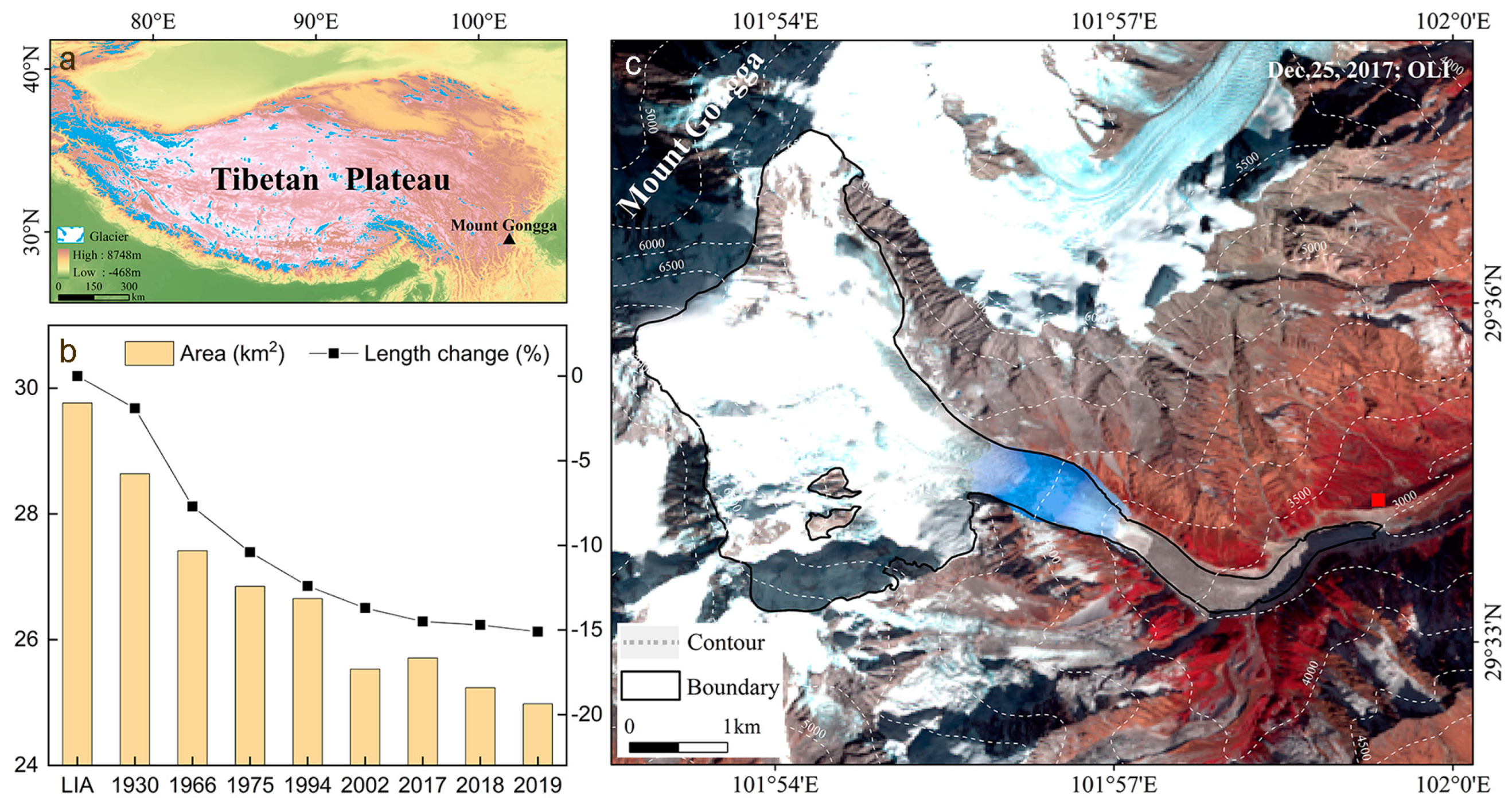
Figure 1. Location of HLG on the eastern slope of Mount Gongga (black triangle) in the southeastern edge of the TP (a), changes in glacier area and length since the Little Ice Age (LIA) (b), and HLG (c) based on Landsat-8 image acquired on 25 December 2017. Red square in (c) denotes the location of GAEORS, and blue color in (c) shows the icefall.
Remotesensing 16 00571 g001
Figure 2. Offset in non-glacier area. The thematic map shows the non-glacier area, and its background shows the average velocity from 18 April 2017 to 12 May 2017.
Remotesensing 16 00571 g002
Figure 3. Glacier central flow line (a) and surface velocity variations of the firn zone (b), the upper part of the icefall (c), the icefall zone (d), the arch bend (e), and the terminus (f) from 2007 to 2019. The background in (a) shows the slope of HLG and its surroundings. Datasets for 2007–2011 and 2014–2018 are from Liu et al. (2019) [45].
Remotesensing 16 00571 g003
Figure 4. Annual (a) and monthly (b) variations in HLG surface velocity along the central flow line during 2015–2019.
Remotesensing 16 00571 g004
Figure 5. Annual and summer surface velocities in the ablation zone below the icefall observed during different periods. Annual datasets for the periods of 1981–1983, 1990–1994, 2007–2011, and 2014–2018 are from Li and Su (1996) [7], Su et al. (1996) [44], Liu et al. (2019) [45], and Liu et al. (2019) [45], respectively, while summer datasets were observed in 1981 [7], 1991 [44], and 2008 [31].
Remotesensing 16 00571 g005
Figure 6. Comparison of time series of modeled mass balance and previous estimates of Xie et al. (2001) [51] (termed Xie dataset) for the period 1988–1997 (a) and mean modeled mass balances and previously estimated values over different periods (b). Error bar in (b) indicates standard error. The number order of 1–6 in (b) denotes the results from Xie et al. (2001) [51], Li et al. (2009) [54], Zhang et al. (2015) [55], Zhang et al. (2012) [41], Li et al. (2010) [54], and Cao et al. (2019) [56], respectively.
Remotesensing 16 00571 g006
Figure 7. Time series of the modeled annual mass balance (a) and cumulative annual mass balance (b) of HLG during the period of 1950–2019.
Remotesensing 16 00571 g007
Figure 8. Spatially variability in mass balance sensitivities of TP glaciers to 1 °C temperature increase (a) and 10% precipitation increase (b). Blue and yellow lines denote the boundaries of maritime and extremely continental glaciers, which are from Shi et al. (2005) [61]. Circle size denotes glacier area size. The details of glaciers in figure and their climate sensitivities can be found in Supplementary Table S2.
Remotesensing 16 00571 g008
Figure 9. Variations in positive temperature sum (a), solid precipitation (b), and shortwave radiation (c) observed at the GAEORS near the glacier terminus for the period 1988–2020. The histograms in (a,b) represent the day with the air temperature above 0 °C and solid precipitation, respectively. Black dash lines indicate the average value of the day number for the period 1988–2020, and red dash dot lines denote the linear fit.
Remotesensing 16 00571 g009
Figure 10. Differences in the mean 500 hPa geopotential heights and wind speed field between the periods of 1988–2005 and 2006–2019 during the monsoonal season (June–September). The red triangle denotes the location of Hailuogou Glacier. Difference is 2006–2019 minus 1988–2005.
Remotesensing 16 00571 g010
Disclaimer/Publisher’s Note: The statements, opinions and data contained in all publications are solely those of the individual author(s) and contributor(s) and not of MDPI and/or the editor(s). MDPI and/or the editor(s) disclaim responsibility for any injury to people or property resulting from any ideas, methods, instructions or products referred to in the content.