Abstract
In arid and semi-arid regions, irrigation is crucial to mitigate water stress and yield loss. However, the overexploitation of water resources by the agricultural sector together with the climate change effects can lead to water scarcity. Effective regional water management depends on estimating irrigation demand using maps of irrigable areas or national and regional statistics of irrigated areas. These statistical data are not always of reliable quality because they generally do not reflect the updated spatial distribution of irrigated and rainfed fields. In this context, remote sensing provides reliable methods for gathering useful agricultural information from derived records. The combined use of optical and radar Earth Observation data enhances the probability of detecting irrigation events, which can improve the accuracy of irrigation mapping. Hence, we aimed to utilize Sentinel-1 (VV and VH) and Sentinel-2 (NDVI) data to classify irrigated fruit trees and rainfed ones in a study area located in the Castilla La-Mancha region in Spain. To obtain these time-series data from Sentinel-1 and Sentinel-2, which constitute the input data for the classification algorithms, a tool has been developed for automating the download from the Sentinel Hub. This tool downloads products organized by tiles for the region of interest and for the entire required time-series, ensuring the spatial repeatability of each pixel across all products and dates. The classification of irrigated plots was carried out by SVM Support Vector Machine. The employed methodology displayed promising results, with an overall accuracy of 88.4%, indicating the methodology’s ability to detect irrigation over orchards that were declared as non-irrigated. These results were evaluated by applying the change detection method of the backscattering coefficient at plot scale.
Keywords:
Sentinel-1; Sentinel-2; irrigation detection; Sentinel hub; classification; SVM; fruit tree orchards; NDVI; VV; VH 1. Introduction
In arid and semi-arid regions, irrigation is crucial to mitigating yield loss caused by drought and water stress [1,2,3]. However, managing water resources is increasingly challenging due to climate change impacts [4,5,6], including rising temperatures and reduced rainfall [7,8,9]. Despite shrinking water supplies, the demand for irrigation has risen as a climate adaptation strategy for farmers [10,11]. Nevertheless, water scarcity often results from overexploitation, particularly in agriculture [11]. To address this, irrigation strategies and policies are essential to save water and ensure equitable distribution [12].
In this context, remote sensing provides reliable methods for retrieving useful agricultural information from their derived records. Among these methods, we can highlight the contextual methods [13] which include the classification application (pixel-based [14], plot-based [15]) and segmentation methods (Object-Based Image Analysis OBIA [16])) established for land use and land cover mapping at several scales (regional or global). This approach exploits the spatial and temporal properties detected in remote sensing images, which can be very helpful for the acquisition of the updated distribution of irrigated and rainfed areas [17]. Hence, classification application-based remote sensing information is used to map irrigated areas and can offer useful tools for optimal irrigation and water resource management.
Detecting irrigated areas has been approached from various perspectives: (i) utilizing different remote sensing products, such as optical-only [18,19,20], microwave-only [21,22], and a combination of both data [23,24], (ii) assessing the impact of different metrics derived from remote sensing data, including the mean, standard deviation, correlation length, and fractal dimension [24,25], and (iii) selecting appropriate machine learning algorithms to differentiate between irrigated and non-irrigated fields, such as Support Vector Machine (SVM) [24,25,26], Random Forest (RF) [18,19,20,27], and K-means clustering [21]. While most of these studies have primarily focused on herbaceous crops, some have included fruit tree classes within the ground truth data [21,24,25,27]. However, as of our current knowledge, there has not been an exclusive study dedicated to the separation of irrigated fruit tree fields from rainfed ones. This gap highlights the need for a specialized investigation in regions experiencing fruit tree field expansion. This dedicated study would address specific challenges, including: (i) the sparse soil cover of these crop types like the trellis-planted vineyards, (ii) the intense vegetative growth of rainfed fruit trees (e.g., almond or pistachio) during summer, potentially complicating the use of optical satellite remote sensing information that can be easily mistaken for irrigated fields, and (iii) the influence of irrigation methods on the irrigation detection, especially when using microwave remote sensing data. Irrigation systems like sprinkler and surface methods exhibit strong microwave signals due to substantial soil moisture, whereas drip irrigation, commonly used for fruit tree crops, involves minimal water usage, making it difficult to detect [28].
In the Castilla-La Mancha region of Spain, there has been a notable increase in fruit orchard surfaces like vines, almonds, and pistachios, which collectively occupied about 31% of the total irrigated field area in 2021 [29]. Particularly in 2021, almond and pistachio cultivation experienced significant growth, witnessing an expansion of around 3.180 hectares compared to that in 2019 [29]. Indeed, over the past decade, a trend of replacing crops has emerged, leading to the transformation of numerous cereal fields into almond tree orchards. This shift has resulted in a rise in almond tree-covered land area, escalating from 411.587 hectares to 625.421 hectares. The driving force behind this expansion is the increased value of almonds in contrast to the lower prices of cereals in the global market. However, this expansion has also brought about the emergence of illicit irrigation practices that must be identified to ensure effective water resource management.
Previous studies have highlighted that the synergistic use of both optical and radar Earth Observation (EO) data enhances the likelihood of detecting irrigation events, consequently improving the precision of irrigation mapping [30,31]. Additionally, achieving accurate irrigation detection demands the utilization of time-series data from high-resolution satellites, which aids in effectively distinguishing between irrigated and rainfed fields. This drives our focus on using Copernicus Sentinel Missions’ Sentinel-1 (radar) and Sentinel-2 (optical) data to classify irrigated fruit trees versus rainfed ones. Nevertheless, implementing this approach presents significant challenges related to Big Data: (i) the substantial volume of EO data that requires downloading, processing, and management [32,33], and (ii) the difficulty of working with data from different sensors [34], entailing handling different spatial, spectral, temporal, and radiometric resolutions, as well as distinct acquisition and processing methods. Consequently, to overcome these constraints, a tool that allows for downloading analysis-ready data (ARD) from the cloud-based Sentinel Hub platform in a user-friendly manner [35] was developed. This tool ensures efficient data management and can perform the classification process. Therefore, the main objective of this study is to detect irrigated fruit orchards in a wide area such as that located in Castilla-La Mancha using public remote sensing (Sentinel 1 and 2) and agricultural information (available GIS information).
2. Materials and Methods
2.1. Study Site
This study was performed over Fuente Alamo, of a surface area of about 133 km2, located in the province of Albacete within the autonomous community of Castilla-La Mancha, Spain, as presented in Figure 1. The area is characterized by a typical Mediterranean semiarid climate with hot and dry summers and daily maximum summer temperatures close to 40 °C, mainly in July and August [36]. Based on the data gathered in the study [37] during the two-year study period (2019–2020) in Fuente Alamo, the annual precipitation fluctuated within the range of 550 mm to 553 mm. The reference evapotranspiration (ET0) exhibited variations between 1270 mm in 2019 and 1185 mm in 2020. Specifically, during the growing season (April to September), rainfall ranged from 400 mm in 2019 to 166 mm in 2020, while ET0 varied from 879 mm in 2019 to 853 mm in 2020. The types of crops that are developed in the area are very diverse, varrying from the traditional base of cereals and corn to the great rise of woody crops such as vines or almond trees. Also, there are vegetables such as garlic, onion, lettuce, and broccoli and industrial crops such as opium poppy [29].
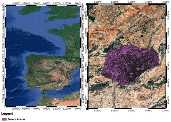
Figure 1.
Presentation of the study area.
2.2. Ground Truth Data
The Geographic Information System for Agricultural Parcels (SIGPAC) data were acquired over the study area and were used for the calibration and validation of the machine learning algorithm. The SIGPAC system, which is a public source of information in Spain, provides both geographical boundaries and alphanumeric information for individual land plots. This includes essential details such as unique identification codes, surface areas, annual updates on land use, irrigation codes indicating whether the land is irrigated (100) or rainfed (0), average slope, and other relevant attributes. The obtained ground truth dataset included a total of 7297 orchards, categorized into rainfed and irrigated fields, as detailed in Table 1. The calibration of the algorithm was carried out by 70% of the data, and the remaining 30% were used to test the trained model. The Table 1 presents the distribution of the orchards across different types, specifying the count for both rainfed and irrigated fields.

Table 1.
Number of Orchards of the Ground Truth Data.
2.3. Acquisition of Sentinel-1 and Sentinel-2 Data
To obtain time series of derived indices from Sentinel-1 and Sentinel-2 satellite missions, the developed tool has been established to automate the use of Sentinel Hub API. It was used to download the EO products organized by tiles for the Fuente Alamo study area and for the entire time series within the timeframe from 1 June 2020 to 31 September 2020, ensuring the spatial repeatability of each pixel across all products and dates. Sentinel Hub offers a useful platform for generating ARD, managing predefined processing scripts and a diverse array of processing choices [35]. This service involves various subscription plans that include features such as data retrieval, the visualization of satellite imagery, scripting capabilities for tasks, and computing vegetation indices [38]. The Sentinel Hub Python package enables the downloading and manipulation of satellite images within Python scripts by employing this framework; users gain access to spatial data, metadata, and processing functionalities. In this work, the used Python scripts were commands for downloading processed bands of NDVI, VV, and VH for the period June 2020–September 2020: 36 acquisition dates for VV and VH from Sentinel-1 and 18 acquisition dates for NDVI Sentinel-2 scenes. Both remote sensing datasets have a spatial resolution of 10 m and were configured to have a temporal resolution of 7 days. In terms of temporal arrangement, the aim was to acquire weekly information from both remote sensing sources and use this information in an integrated manner. It is noteworthy that the normal coverage (temporal resolution) of Sentinel-2 over the study area is typically 3–4 days, while for Sentinel-1, it is 6 days. Consequently, for Sentinel-1, the weekly information requirement is met. However, for Sentinel-2, a filtering process was implemented. This involved selecting the appropriate Sentinel-2 scene based on two criteria: (i) having a date within the required temporal resolution (in this case, within a week) and (ii) the absence of cloud coverage over the study area. It is important to highlight that the application of these criteria and the download of these EO data were specific to the study area, meaning not all the scenes of the selected date were downloaded but rather only the specific portion that corresponds to the study area. This operation was executed using a strategy where special spatial regions (called Tuplekeys) were created within a local nested grid, as was explained in more detail in [34].
In this study case, VH and VV backscattering bands of Sentinel-1 were considered. The mean of these features was computed by averaging the backscattering coefficient sigma nought across all pixels within each plot (plot-based approach) for each date within the selected time series. Regarding Sentinel-2 optical data, the mean NDVI (Normalized Difference Vegetation Index) was calculated based on downloaded NDVI scenes for each available date in the Sentinel-2 time series.
2.4. Meteorological Data
The used meteorological data, specifically rainfall data, were obtained from SiAR (https://servicio.mapa.gob.es/websiar/ accessed on 27 March 2023). The Spanish Ministry of Agriculture and Fisheries, Food, and the Environment, through the General Sub-directorate for Irrigation and Rural Infrastructures, makes all the information collected through the SiAR Network of agrometeorological stations available to users free of charge. The rainfall information obtained from the SiAR Network of the agrometeorological station closest to Fuente Alamo was used to complement the results of the validation of classification. This was included with the graphs representing the validation of classification results through the change detection of at plot scales. These visualizations enable an understanding of how precipitation may influence the variation in the VV SAR value . For instances where no obvious precipitation is recorded, the observed increase in the SAR value between successive VV SAR acquisition dates may signify a possible irrigation event. Therefore, the integration of rainfall data serves as accompanying data in interpreting the validation of the classification results, providing knowledge of the conditions affecting the observed variations in the SAR signal.
2.5. Overview of Irrigation Detection Methodology
To differentiate between irrigated fruit orchards and rainfed ones, a classification approach was used based on analyzing satellite image time series—a method commonly used in such contexts. However, managing time-series from diverse satellite sensors, such as Sentinel-1 (SAR) and Sentinel-2 (optical), presented challenges in handling the extensive data volume, including download, processing, and management. To overcome this, the developed tool facilitated the download of a subset of ARD images specific to the study area from the Sentinel-hub platform. Operating with the zonal statistics embedded in this tool enabled obtaining the mean of NDVI, as well as VV and VH, at the plot scale for each available date of the time-series dataset. The output of this step served as training data for calibrating the selected machine learning algorithm, which was the linear Support Vector Machine. Therefore, when the machine learning model was calibrated and was tested to detect the irrigated fruit fields that were designated as non-irrigated in the SIGPAC database, they were probably being irrigated. The confusion matrix, as well as the classic performance indicators (overall accuracy (OA), producer’s accuracy (PA), and user’s accuracy (UA)), were calculated. These were the main steps of the classification methodology, as outlined in Figure 2.

Figure 2.
General workflow.
2.6. Validation of Classification Results: Change Detection of the Sigma Nought at the Plot Scale
In order to assess the output results of the developed tool, which are the fields that were labeled as non-irrigated but were detected as being irrigated, we decided to apply the proposed method described in detail in [31] and based on detecting the change in the sigma nought backscattering coefficient at the plot scale. This method is grounded in the fact that if there is an increase in the SAR value between two successive SAR acquisition dates, then an irrigation event may have occurred [39]. Also, the insignificant decrease in values between these two dates or the stability may possibly be related to an irrigation. Otherwise, a decrease in between the successive times time and time , during the spring and summer seasons means that there was no irrigation event.
The method [31] proposed calculating, at each VV acquisition, the difference in the plot scale between successive SAR acquisition dates. Therefore, the at the plot scale was calculated as follows:
where is the in VV polarization at the present SAR date and is the in VV polarization at the previous date.
For possible irrigation events of the fruit orchard, we suggest three main thresholds for the value:
The first threshold, if is less than or equals −0.5 dB, corresponds to no possible irrigation events: a low irrigation probability.
The second threshold, if the is greater than or equal to 0.5 dB, corresponds to possible irrigation events: a high irrigation probability.
The third threshold, if the is between −0.5 dB and 0.5 dB, corresponds to a stabilization or a slight decrease, which also means a possible irrigation event: a medium irrigation probability.
By applying the thresholds predefined by the method [31], we found that it is necessary to reduce the maximum threshold of high and medium irrigation probability from 1 dB to 0.5 dB because in the case of woody crops, the proportion of bare soil is higher than in herbaceous crops; hence, there is a higher rate of evaporation. Therefore, we cannot observe a considerable increase in SAR backscattering signals.
3. Results
3.1. Exploratory Data Analysis for the Machine Learning Algorithm: Visualization of Time Series for Trend Analysis
Figure 3, Figure 4 and Figure 5 represent the VV, VH, and NDVI time series, irrigated and non-irrigated, of both vineyard and almond orchards for the period March–August. It is important to note that the classification was carried out using time-series data only for the period June–September, which aligns with the typical irrigation season based on the climate conditions of the study area. However, Figure 3, Figure 4 and Figure 5 provide a presentation of these time-series ranging from March to September. This extended timeframe allows for observing the behavior of VV and VH data, during periods when potential rain events may occur. The analysis of the temporal variation in the selected features is the first step to possibly separating the two types of classes. Additionally, the purpose of displaying these figures was to demonstrate the difference between these irrigated and non-irrigated crops. Indeed, in observing these temporal signature dynamics, it is noticeable that there is a remarkable difference between them and those for both the almond and vineyard orchards. Indeed, irrigated plots present a higher backscattering coefficient then the non-irrigated plots.

Figure 3.
VV temporal signatures of irrigated and non-irrigated vineyard and almond plots.

Figure 4.
VH temporal signatures of irrigated and non-irrigated vineyard and almond plots.
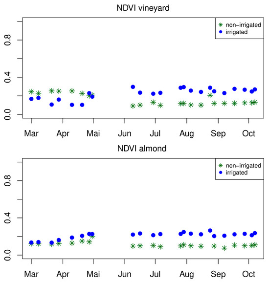
Figure 5.
NDVI temporal signatures of irrigated and non-irrigated vineyard and almond plots.
In Figure 3, for vineyard crops, we can observe that during the irrigation period (June–August), the VV curve of the irrigated plot presented alternations between highs and lows, which can be explained by the sensitivity of VV to the variation in the water content of the land surface due to irrigation [40,41,42,43,44,45]. However, the VV of non-irrigated plots was more or less steady during the same period. Concerning almond plots, we can notice that out of the irrigation period (March–April), the difference between irrigated and non-irrigated plots is barely noticeable; even in some dates in April, the backscattering coefficient of non-irrigated orchards was higher than the backscattering coefficient of the irrigated ones.
For VH polarization, in Figure 4, it can be observed that the irrigated plots have higher backscatter coefficient values than the non-irrigated ones, for both crop types. Although VH is less sensitive to the soil moisture, in the case of woody crops, there is a predominance of soil backscatter due to the open spaces between, for example, vine trees, but the irrigation impact is well reflected by the vegetation density. Indeed, the irrigated trees normally have a higher density than the non-irrigated ones, which can be observed by the vegetation development which affects the backscatter coefficient for VH polarization.
In Figure 5, the same observation was made for VV and VH polarizations: irrigated plots have higher NDVI values than the non-irrigated ones, especially during the summer period. The time-series of NDVI of the irrigated almond plot demonstrated a similar pattern [46]. Moreover, the observed NDVI temporal behavior of the vine during the period of June–August, ranging between 0.2 and 0.4, can be considered as a normal development of the grapevine canopy in typical Mediterranean weather conditions [46].
3.2. Feature Importance Analysis
The importance of the various features utilized (NDVI, VV, and VH) for each date within the selected classification period (1 June 2020 to 31 September 2020) was determined through the application of the Random Forest model, employing the Out-of-Bag (OOB) permutation feature importance technique, as presented in Figure 6. This approach employed the OOB samples to determine the influence of each feature by introducing random permutations to its values, while keeping other predictors unchanged. The determination of feature importance was based on the degree of modification in the model’s accuracy or error. Features that led to a pronounced decline in the model’s means have important contributions to the model’s predictive ability. Afterward, these computed importance scores were employed to arrange the features in descending order of their influence on the model’s performance. For instance, as is shown by Figure 5, the VH values acquired on 14 July 2020 have an importance value equal to 1.5, meaning that permuting the values of that predictor resulted in a performance decrease of 1.5 units on average across the ensemble of trees. This drop in performance indicates that this feature is contributing significantly to the model’s accuracy or error, making it the most important feature for making accurate predictions. Figure 5 reveals that the three most important predictors were based on VH observations (acquired on 14 July 2020, 28 July 2020, and 29 September 2020), demonstrating the importance of SAR imagery during the key periods of the summer season in detecting irrigation over fruit fields. This observation provides support to the notion that irrigated trees exhibit a higher backscatter coefficient for VH polarization, explained by the augmented vegetation density resulting from irrigation. Consequently, VH emerges as the principal variable for distinguishing between irrigated and rainfed trees.

Figure 6.
Feature importance for the discrimination between irrigated and rainfed fruit tree orchards, sorted by date.
3.3. Irrigation Detection Results
In the Fuente Alamo study area, the methodology previously described was applied utilizing data from the SIGPAC database within the timeframe from 1 June 2020 to 31 September 2020. The primary objective of this work was to rigorously evaluate the effectiveness of our tool in identifying plots that were designated as non-irrigated yet, probably, were being irrigated. It is imperative to underscore that the selected study period has been meticulously aligned with the region’s characteristics—a semi-arid locale characterized by a dry summer. This selection is particularly significant, as the preponderance of irrigation activities typically occurs during the summer months, extending from June through September. The overall accuracy (OA) of the integrated algorithm within our developed tool, the Support Vector Machine (SVM), was equal to 88.4%. Table 2 presents the confusion matrix of the classification performed by the Linear SVM. It shows the number of cases predicted for each class (rainfed and irrigated) compared to the actual number. For example, 1854 rainfed orchards were correctly predicted, but 31 were incorrectly predicted as irrigated. On the other hand, 249 irrigated fields were incorrectly predicted as rainfed, and 98 instances of irrigated ones were correctly predicted.
Table 2.
Confusion matrix.
Figure 7 displayed some examples of plots, each associated with its corresponding SIGPAC ID code, that were identified as irrigated despite being labeled as non-irrigated in the SIGPAC database. Moreover, as part of the analysis, the precipitation graph with each suspicious plot was incorporated. These graphs enable visually realizing the potential impact of rainfall on the VV backscattering signal. Conversely, in cases where no discernible precipitation is present, the increase in the SAR value between successive VV SAR acquisition dates may potentially indicate the occurrence of an irrigation event. Among these fourteen plots, one is dedicated to almond cultivation, two host olive cultures, and the remaining plots are vineyards. Furthermore, Figure 7 presents the outcomes of the validation methodology based on change detection. In this visualization, the blue, green, and red points are possible irrigation points spotted on the VV backscattering signal with high, medium, and low certainty, respectively. Evaluating these classification–validation outcomes showed that out of the fourteen detected plots, four stand out as particularly suspicious. These four plots, denoted as (a), (b), (c), and (d) in Figure 7, displayed the highest instances of “high-probability irrigation” as depicted by the blue points. It is important to mention that these plots do not have the same crop: (a) and (b) are occupied by vines, (c) have olive trees, and (d) have fruit trees. Figure 8 shows the spatial distribution of these fourteen detected plots, with spatial zoom on the most suspicious plots denoted as (a), (b), (c), and (d), as in Figure 7.


Figure 7.
The detected irrigated fields that have been declared non-irrigated: (a) the field with plot ID 861051808, (b) the field with plot ID 861053581, (c) the field with plot ID 1268234036, and (d) the field with plot ID 1289046307, (e) the field with plot ID 1158332486 , (f) the field with plot ID 1200493165, (g) the field with plot ID 861065401, (h) the field with plot ID 1268234046, (i) the field with plot ID 1268234047, (j) the field with plot ID 1268234086, (k) the field with plot ID 1116185623, (l) the field with plot ID 1290915269, (m) the field with plot ID 1388489254, (n) the field with plot ID 1617271892.

Figure 8.
The spatial distribution of the fourteen detected plots, with zoom on (a) the field with plot ID 861051808, (b) the field with plot ID 861053581, (c) the field with plot ID 1268234036, and (d) the field with plot ID 1289046307.
4. Discussion
The methodology of the developed tool was conceived to surround two main constraints: (i) the complexity of exploiting time-series data acquired from different sensors [33] (for example: different acquisition and processing approaches and different spatial, spectral, temporal, and radiometric resolutions), and (ii) the management of the volume of these data [32] (for example: exceeding the memory, storage, and processing capacities of personal computers). That is why it was based on the combination of the advantages of the Sentinel Hub cloud-based platform technology and the Tuplekeys strategy. The developed tool allowed for the automatic acquisition of time-series of Analysis-Ready Data (ARD) Sentinel-1 and Sentinel-2 data from the Sentinel Hub API. This automated process not only saves time but also ensures the systematic organization of a substantial volume of remote sensing products obtained from two different sources. The data are structured by tiles for the specified region of interest and for the entire timeseries, ensuring the spatial repeatability for each pixel across all products and dates. Furthermore, the tool incorporates a zonal statistic function, enabling the automatic extraction of the mean of derived indices from selected remote sensing data for each plot and available time-series date, as in [47]. This functionality significantly simplifies a typically time-consuming process if performed manually. Additionally, the remaining steps of the classification process are also automated.
Examining the three features used (NDVI, VH, and VV) for discerning between irrigated and rainfed fruit tree orchards, the conducted test revealed VH as the most important variable. VV was found in the second place, which is expected given its sensitivity to the variation in the water content of the land surface due to irrigation. Concerning NDVI, it ranked as the least influential feature in this classification process. Consequently, depending on the classification purpose, a feature can be more important than another [48]. The linear SVM model, overall, performed well, achieving an accuracy of 88.4%. Indeed it was proven that SVM is suitable when combining the use of optical and SAR data, as stated in [49]. It accurately predicts rainfed orchards, reflected in good User and Producer Accuracy values. However, the model’s accuracy for irrigated orchards is not as strong as for rainfed ones, though the Producer Accuracy remains acceptable. This difference may be explained by (i) the fact that the water rights for irrigating these types of crops is really low (around 1000 m3 ha−1), which makes it difficult to detect the irrigation events (few irrigation events and with low doses), and (ii) the imbalance between the number of rainfed and irrigated fields. Nevertheless, we cannot change the fact that the ground truth data present a higher number of rainfed fields than irrigated ones. This means that we do need to perform further analysis and improve the potential of the machine learning model with the objective to increase the accuracy of the classification results and their indicators.
Analyzing these fourteen plots, all of them have a relatively high mean slope, ranging from 17% to 52%. This observation carries significant implications in interpreting the obtained results. As highlighted in the study by [25], where they found that the non-irrigated fields that were wrongly classified into irrigated crops were high, with a percentage of 14.5%, most of them are located in the mountainous areas, where they may be influenced by topography. However, to mitigate the impact of topography, a potential solution lies in the application of a “cosine correction”. This correction seeks to minimize the repercussions of backscatter variations across the swath due to varying incidence angles. Additionally, for more precise values, local slope information is essential, which can often be obtained through a digital elevation model (DEM). This process, known as radiometric normalization, enables the normalization of an SAR image to a local incidence angle, a projected local incidence angle, or an incidence angle derived from an ellipsoid.
The SIGPAC database served as the ground truth data for training and validating the machine learning algorithm. However, it is important to note that not all data within the SIGPAC were verified. As outlined in the study [21], the SIGPAC database classifies fields as either irrigated or non-irrigated based on their potential to be connected to an irrigation network. This classification does not necessarily guarantee that a field is actively irrigated, as instances may arise where the irrigation infrastructure is not yet established. Therefore, for our future work, an additional validation step is imperative. This secondary validation should be conducted by the additional verification of the training information to ensure the algorithm’s calibration is accurate and dependable.
5. Conclusions
In conclusion, this study has addressed the critical issue of accurate irrigation detection in semi-arid regions, where water scarcity and an increasing demand for irrigation present significant challenges. The utilization of remote sensing methods, specifically the synergy between optical and radar EO data, has demonstrated its efficacy in detecting irrigation events through the implementation of a classification methodology based on time-series analysis. The automatic acquisition of the time-series of derived indices extracted from Sentinel-1 and Sentinel-2 data was performed via a specialized tool that has been developed to acquire the remote sensing from Sentinel Hub. This tool guarantees the spatial repeatability of each pixel across all products and dates, as well as the automatic process of the classification steps.
The obtained results after the application of the explained methodology over the study area were promising, with an overall accuracy of 88.4% of the calibrated SVM, indicating the possible methodology’s ability to detect irrigated plots that were misclassified as non-irrigated in the SIGPAC database. Furthermore, among the three features utilized (NDVI, VH, and VV), the conducted test for determining the most important factor in discriminating between irrigated and rainfed fruit tree orchards revealed that VH stands out as the primary variable.
The consideration of topographical factors in the interpretation of classification results highlighted the need for additional correction techniques to account for the impact of slope variations. However, it is imperative to acknowledge the limitations of the SIGPAC database in terms of the complete verification of its data. This emphasizes the necessity of a secondary validation step to ensure the accuracy of the machine learning algorithm’s calibration. Future research should focus on refining the methodology by integrating more verified ground truth data and additional SAR image correction to mitigate the impact of topography.
Author Contributions
Conceptualization, D.H.-L., M.A.M. and R.B.; methodology, A.C.; software, D.H.-L. and M.A.M.; validation, A.C.; formal analysis, A.C.; investigation, A.C., D.H.-L. and M.A.M.; resources, R.B. and M.A.M.; data curation, D.H.-L., M.A.M. and A.C.; writing—original draft preparation, A.C.; writing—review and editing, A.C. and M.A.M.; visualization, A.C.; supervision, M.A.M. and R.B.; project administration, R.B.; funding acquisition, R.B. and M.A.M. All authors have read and agreed to the published version of the manuscript.
Funding
This research was funded by the Spanish Ministry of Science and Innovation, grant number PID2020-115998RB-C22 (Co-funded by FEDER), and by EU HORIZON-CL6-2021 GOVERNANCE-01 CALL Project CHAMELEON 101060529.
Data Availability Statement
Data are contained within the article.
Conflicts of Interest
The authors declare no conflicts of interest.
References
- Howell, T.A.; Hiler, E.A.; Reddell, D.L. Optimization of Water Use Efficiency Under High Frequency Irrigation—2. System Simulation and Dynamic Programming. Trans. ASAE 1974, 18, 879–887. [Google Scholar] [CrossRef]
- Hanks, R.J. Model or Predicting Plant Yield as Influenced by Water Use. Agron. J. 1974, 66, 660–665. [Google Scholar] [CrossRef]
- Pejić, B.; Maksimović, L.; Škorić, D.; Milić, S.; Stričević, R.; Ćupina, B. Effect of Water Stress on Yield and Evapotranspiration of Sunwlower. Helia 2009, 32, 19–32. [Google Scholar] [CrossRef]
- Luo, P.; Sun, Y.; Wang, S.; Wang, S.; Lyu, J.; Zhou, M.; Nakagami, K.; Takara, K.; Nover, D. Historical Assessment and Future Sustainability Challenges of Egyptian Water Resources Management. J. Clean. Prod. 2020, 263, 121154. [Google Scholar] [CrossRef]
- Tzanakakis, V.A.; Angelakis, A.N.; Paranychianakis, N.V.; Dialynas, Y.G.; Tchobanoglous, G. Challenges and Opportunities for Sustainable Management of Water Resources in the Island of Crete, Greece. Water 2022, 14, 1024. [Google Scholar] [CrossRef]
- Calicioglu, O.; Flammini, A.; Bracco, S.; Bellù, L.; Sims, R. The Future Challenges of Food and Agriculture: An Integrated Analysis of Trends and Solutions. Sustainability 2019, 11, 222. [Google Scholar] [CrossRef]
- Zhang, Q.; Xu, C.Y.; Zhang, Z.; Chen, Y.D.; Liu, C.; Lin, H. Spatial and Temporal Variability of Precipitation Maxima during 1960–2005 in the Yangtze River Basin and Possible Association with Large-Scale Circulation. J. Hydrol. 2008, 353, 215–227. [Google Scholar] [CrossRef]
- Zhang, Q.; Xu, C.Y.; Tao, H.; Jiang, T.; Chen, Y.D. Climate Changes and Their Impacts on Water Resources in the Arid Regions: A Case Study of the Tarim River Basin, China. Stoch. Environ. Res. Risk Assess. 2010, 24, 349–358. [Google Scholar] [CrossRef]
- Jamali, M.; Gohari, A.; Motamedi, A.; Haghighi, A.T. Spatiotemporal Changes in Air Temperature and Precipitation Extremes over Iran. Water 2022, 14, 3465. [Google Scholar] [CrossRef]
- Tramblay, Y.; Koutroulis, A.; Samaniego, L.; Vicente-Serrano, S.M.; Volaire, F.; Boone, A.; Le Page, M.; Llasat, M.C.; Albergel, C.; Burak, S.; et al. Challenges for Drought Assessment in the Mediterranean Region under Future Climate Scenarios. Earth-Sci. Rev. 2020, 210, 103348. [Google Scholar] [CrossRef]
- Ferguson, C.R.; Pan, M.; Oki, T. The Effect of Global Warming on Future Water Availability: CMIP5 Synthesis. Water Resour. Res. 2018, 54, 7791–7819. [Google Scholar] [CrossRef]
- Russo, T.; Alfredo, K.; Fisher, J. Sustainable Water Management in Urban, Agricultural, and Natural Systems. Water 2014, 6, 3934–3956. [Google Scholar] [CrossRef]
- Weiss, M.; Jacob, F.; Duveiller, G. Remote Sensing for Agricultural Applications: A Meta-Review. Remote Sens. Environ. 2019, 236, 111402. [Google Scholar] [CrossRef]
- Piedelobo, L.; Hernández-López, D.; Ballesteros, R.; Chakhar, A.; Del Pozo, S.; González-Aguilera, D.; Moreno, M.A. Scalable Pixel-Based Crop Classification Combining Sentinel-2 and Landsat-8 Data Time Series: Case Study of the Duero River Basin. Agric. Syst. 2019, 171, 36–50. [Google Scholar] [CrossRef]
- Kussul, N.; Lemoine, G.; Gallego, F.J.; Skakun, S.V.; Lavreniuk, M.; Shelestov, A.Y. Parcel-Based Crop Classification in Ukraine Using Landsat-8 Data and Sentinel-1A Data. IEEE J. Sel. Top. Appl. Earth Obs. Remote Sens. 2016, 9, 2500–2508. [Google Scholar] [CrossRef]
- Hossain, M.D.; Chen, D. Segmentation for Object-Based Image Analysis (OBIA): A Review of Algorithms and Challenges from Remote Sensing Perspective. ISPRS J. Photogramm. Remote Sens. 2019, 150, 115–134. [Google Scholar] [CrossRef]
- Velpuri, N.M.; Thenkabail, P.S.; Gumma, M.K.; Biradar, C.; Dheeravath, V.; Noojipady, P.; Yuanjie, L. Influence of Resolution in Irrigated Area Mapping and Area Estimation. Photogramm. Eng. Remote Sens. 2009, 75, 1383–1395. [Google Scholar] [CrossRef]
- Deines, J.M.; Kendall, A.D.; Crowley, M.A.; Rapp, J.; Cardille, J.A.; Hyndman, D.W. Mapping Three Decades of Annual Irrigation across the US High Plains Aquifer Using Landsat and Google Earth Engine. Remote Sens. Environ. 2019, 233, 111400. [Google Scholar] [CrossRef]
- Xie, Y.; Lark, T.J.; Brown, J.F.; Gibbs, H.K. Mapping Irrigated Cropland Extent across the Conterminous United States at 30 m Resolution Using a Semi-Automatic Training Approach on Google Earth Engine. ISPRS J. Photogramm. Remote Sens. 2019, 155, 136–149. [Google Scholar] [CrossRef]
- Zurqani, H.A.; Allen, J.S.; Post, C.J.; Pellett, C.A.; Walker, T.C. Mapping and Quantifying Agricultural Irrigation in Heterogeneous Landscapes Using Google Earth Engine. Remote Sens. Appl. Soc. Environ. 2021, 23, 100590. [Google Scholar] [CrossRef]
- Dari, J.; Quintana-Seguí, P.; Escorihuela, M.J.; Stefan, V.; Brocca, L.; Morbidelli, R. Detecting and Mapping Irrigated Areas in a Mediterranean Environment by Using Remote Sensing Soil Moisture and a Land Surface Model. J. Hydrol. 2021, 596, 126129. [Google Scholar] [CrossRef]
- Lawston, P.M.; Santanello, J.A.; Kumar, S.V. Irrigation Signals Detected From SMAP Soil Moisture Retrievals. Geophys. Res. Lett. 2017, 44, 11860–11867. [Google Scholar] [CrossRef]
- Gao, H.; Wang, C.; Wang, G.; Zhu, J.; Tang, Y.; Shen, P.; Zhu, Z. A Crop Classification Method Integrating GF-3 PolSAR and Sentinel-2A Optical Data in the Dongting Lake Basin. Sensors 2018, 18, 3139. [Google Scholar] [CrossRef]
- Elwan, E.; Page, M.L.; Jarlan, L.; Baghdadi, N.; Brocca, L.; Modanesi, S.; Dari, J.; Segui, P.Q.; Zribi, M. Irrigation Mapping on Two Contrasted Climatic Contexts Using Sentinel-1 and Sentinel-2 Data. Water 2022, 14, 804. [Google Scholar] [CrossRef]
- Gao, Q.; Zribi, M.; Escorihuela, M.J.; Baghdadi, N.; Segui, P.Q. Irrigation Mapping Using Sentinel-1 Time Series at Field Scale. Remote Sens. 2018, 10, 1495. [Google Scholar] [CrossRef]
- Bousbih, S.; Zribi, M.; Hajj, M.E.; Baghdadi, N.; Lili-Chabaane, Z.; Gao, Q.; Fanise, P. Soil Moisture and Irrigation Mapping in a Semi-Arid Region, Based on the Synergetic Use of Sentinel-1 and Sentinel-2 Data. Remote Sens. 2018, 10, 1953. [Google Scholar] [CrossRef]
- Lu, Y.; Song, W.; Su, Z.; Lü, J.; Liu, Y.; Li, M. Mapping Irrigated Areas Using Random Forest Based on GF-1 Multi-Spectral Data. Int. Arch. Photogramm. Remote Sens. Spat. Inf. Sci.-ISPRS Arch. 2020, 43, 697–702. [Google Scholar] [CrossRef]
- Massari, C.; Modanesi, S.; Dari, J.; Gruber, A.; De Lannoy, G.J.M.; Girotto, M.; Quintana-Seguí, P.; Le Page, M.; Jarlan, L.; Zribi, M.; et al. A Review of Irrigation Information Retrievals from Space and Their Utility for Users. Remote Sens. 2021, 13, 4112. [Google Scholar] [CrossRef]
- JCRMO Memoria 2020–2021. 2021. Available online: http://jcrmo.org/wp-content/uploads/2022/05/memoria-jcrmo-2020-2021.pdf (accessed on 27 March 2023).
- Bazzi, H.; Baghdadi, N.; Amin, G.; Fayad, I.; Zribi, M.; Demarez, V.; Belhouchette, H. An Operational Framework for Mapping Irrigated Areas at Plot Scale Using Sentinel-1 and Sentinel-2 Data. Remote Sens. 2021, 13, 2584. [Google Scholar] [CrossRef]
- Bazzi, H.; Baghdadi, N.; Fayad, I.; Zribi, M.; Belhouchette, H.; Demarez, V. Near Real-Time Irrigation Detection at Plot Scale Using Sentinel-1 Data. Remote Sens. 2020, 12, 1456. [Google Scholar] [CrossRef]
- Benediktsson, A.; Ieee, F.; Sun, Z.; Shen, J.; Zhu, Y. Big Data for Remote Sensing : Challenges and Opportunities. Proc. IEEE 2016, 104, 2207–2219. [Google Scholar]
- Ma, Y.; Wu, H.; Wang, L.; Huang, B.; Ranjan, R.; Zomaya, A. Remote Sensing Big Data Computing : Challenges and Opportunities. Futur. Gener. Comput. Syst. 2015, 51, 47–60. [Google Scholar] [CrossRef]
- Hernández-López, D.; Piedelobo, L.; Moreno, M.A.; Chakhar, A.; Ortega-Terol, D.; González-Aguilera, D. Design of a Local Nested Grid for the Optimal Combined Use of Landsat 8 and Sentinel 2 Data. Remote Sens. 2021, 13, 1546. [Google Scholar] [CrossRef]
- Milcinski, G.; Kolaric, P. Sentinel Hub—Federated on-Demand ARD Generation. In Proceedings of the EGU General Assembly 2023, Vienna, Austria, 24–28 April 2023. EGU23-4160. [Google Scholar] [CrossRef]
- Climate Zones. National Geographic Institute (NGI). Available online: https://www.ign.es/espmap/mapas_clima_bach/pdf/%0AClima_Mapa_1_2texto.pdf (accessed on 20 March 2022).
- López-García, P.; Ortega, J.F.; Pérez-Álvarez, E.P.; Moreno, M.A.; Ramírez, J.M.; Intrigliolo, D.S.; Ballesteros, R. Yield Estimations in a Vineyard Based on High-Resolution Spatial Imagery Acquired by a UAV. Biosyst. Eng. 2022, 224, 227–245. [Google Scholar] [CrossRef]
- Dyke, G.; Rosenqvist, A.; Killough, B.; Yuan, F. Intercomparison of Sentinel-1 Datasets From Google Earth Engine and the Sinergise Sentinel Hub Card4L Tool. In Proceedings of the 2021 IEEE International Geoscience and Remote Sensing Symposium IGARSS, Brussels, Belgium, 11–16 July 2021; pp. 1796–1799. [Google Scholar] [CrossRef]
- El Hajj, M.; Baghdadi, N.; Belaud, G.; Zribi, M.; Cheviron, B.; Courault, D.; Hagolle, O.; Charron, F. Irrigated Grassland Monitoring Using a Time Series of TerraSAR-X and COSMO-SkyMed X-Band SAR Data. Remote Sens. 2014, 6, 10002–10032. [Google Scholar] [CrossRef]
- Dobson, M.C.; Ulaby, F. Microwave Backscatter Dependence on Surface Roughness, Soil Moisture, and Soil Texture: Part III—Soil Tension. IEEE Trans. Geosci. Remote Sens. 1981, GE-19, 51–61. [Google Scholar] [CrossRef]
- Ulaby, F.T.; Moore, R.K.; Fung, A.K. Microwave Remote Sensing: Active and Passive. Volume 1—Microwave Remote Sensing Fundamentals and Radiometry; Artech House, Ed.; Artech House: Boston, MA, USA, 1986. [Google Scholar]
- Baghdadi, N.; Gherboudj, I.; Zribi, M.; Sahebi, M.; King, C. Semi-Empirical Calibration of the IEM Backscattering Model Using Radar Images and Moisture and Roughness Field Measurements. Int. J. Remote Sens. 2004, 25, 3593–3623. [Google Scholar] [CrossRef]
- Ulaby, F.T.; Razani, M.; Dobson, M.C. Effects of Vegetation Cover on the Microwave Radiometric Sensitivity to Soil Moisture. IEEE Trans. Geosci. Remote Sens. 1983, GE-21, 51–61. [Google Scholar] [CrossRef]
- Hallikainen, M.T.; Ulaby, F.T.; Dobson, M.C.; El-Rayes, M.A.; Wu, L.-K. Microwave Dielectric Behavior of Wet Soil-Part I: Empirical Models. IEEE Trans. Geosci. Remote Sens. 1985, GE-23, 25–34. [Google Scholar] [CrossRef]
- Oh, Y.; Sarabandi, K.; Ulaby, F.T. An Empirical Model and an Inversion Technique for Radar Scattering from Bare Soil Surfaces. IEEE Trans. Geosci. Remote Sens. 1992, 30, 370–381. [Google Scholar] [CrossRef]
- González-Gómez, L.; Intrigliolo, D.S.; Rubio-Asensio, J.S.; Buesa, I.; Ramírez-Cuesta, J.M. Assessing Almond Response to Irrigation and Soil Management Practices Using Vegetation Indexes Time-Series and Plant Water Status Measurements. Agric. Ecosyst. Environ. 2022, 339, 108124. [Google Scholar] [CrossRef]
- Chakhar, A.; Hernández-López, D.; Zitouna-Chebbi, R.; Mahjoub, I.; Ballesteros, R.; Moreno, M.A. Optimized Software Tools to Generate Large Spatio-Temporal Data Using the Datacubes Concept: Application to Crop Classification in Cap Bon, Tunisia. Remote Sens. 2022, 14, 5013. [Google Scholar] [CrossRef]
- Zhang, H.; Wang, Y.; Shang, J.; Liu, M.; Li, Q. Investigating the Impact of Classification Features and Classifiers on Crop Mapping Performance in Heterogeneous Agricultural Landscapes. Int. J. Appl. Earth Obs. Geoinf. 2021, 102, 102388. [Google Scholar] [CrossRef]
- Chachondhia, P.; Shakya, A.; Kumar, G. Performance Evaluation of Machine Learning Algorithms Using Optical and Microwave Data for LULC Classification. Remote Sens. Appl. Soc. Environ. 2021, 23, 100599. [Google Scholar] [CrossRef]
Disclaimer/Publisher’s Note: The statements, opinions and data contained in all publications are solely those of the individual author(s) and contributor(s) and not of MDPI and/or the editor(s). MDPI and/or the editor(s) disclaim responsibility for any injury to people or property resulting from any ideas, methods, instructions or products referred to in the content. |
© 2024 by the authors. Licensee MDPI, Basel, Switzerland. This article is an open access article distributed under the terms and conditions of the Creative Commons Attribution (CC BY) license (https://creativecommons.org/licenses/by/4.0/).