Abstract
Urbanization in South and Southeast Asia is accelerating due to economic growth, industrialization, and rural-to-urban migration, with megacities like Mumbai, Delhi, and Jakarta leading the trend. By analyzing VIIRS nighttime satellite data from 323 cities across 17 countries, we investigated the relationship between nighttime light (NTL) brightness and population density at varying distances from city centers. Our findings reveal a significant distance-decay effect, with both the intensity of NTL brightness and the strength of the NTL-population density relationship decreasing as the distance from city centers increases. A clear negative exponential relationship with the highest R2 was observed between NTL brightness and the distance from the city center. Our analysis indicates that a 105 km radius most effectively captures the extent of major metropolitan areas, showing a peak correlation between NTL brightness and population density. Cities like Delhi and Bangkok exhibit high NTL brightness, reflecting advanced infrastructure, while mountainous or desert cities such as Kabul and Thimphu show lower brightness due to geographical constraints. These results highlight the importance of adaptive urban planning, infrastructure development, and sustainability practices in managing urbanization challenges in South and Southeast Asia.
1. Introduction
Urbanization in South and Southeast Asian countries is occurring rapidly, driven by economic growth, industrialization, and rural-to-urban migration [1]. These countries are home to some of the world’s most densely populated and fastest-growing cities, which play a crucial role in the global economy. The region boasts several megacities, defined as cities with populations exceeding 10 million. Examples include Mumbai, Delhi, Dhaka, Karachi, Manila, and Jakarta [2,3]. These megacities often extend into vast metropolitan regions, incorporating surrounding towns and peri-urban areas, i.e., regions transitioning from rural to urban settings. Also, several cities in Asia are reported to have unplanned and haphazard urban sprawl, resulting in informal settlements, inadequate infrastructure, and environmental degradation [4,5,6,7]. Managing urban sprawl is a critical challenge for city planners in several South and Southeast Asian countries as the unplanned expansion and the proliferation of informal settlements and slums are common. The surge in informal settlements exacerbates issues of inadequate access to basic services like clean water, sanitation, and electricity [8,9,10]. Additionally, the region grapples with severe traffic congestion issues stemming from insufficient public transportation systems and a rapid rise in private vehicle ownership, which worsens air pollution impacting both air quality and health [11]. To address these concerns, the continuous mapping and monitoring of urban areas is important. For the same, satellite remote sensing offers unique solutions due to its multi-temporal, multi-spectral, synoptic, and repetitive coverage capabilities.
Most importantly, nighttime lights mapped from satellites have become a valuable tool for researchers to study urbanization [12]. The use of nighttime lights as a surrogate indicator of urbanization stems from the strong correlation between illuminated areas and human activities [13,14]. Urban areas, characterized by a high population density and extensive infrastructure, tend to emit more artificial light compared to rural or undeveloped regions. By analyzing satellite imagery of nighttime lights, researchers can infer the extent and intensity of urban development, providing a proxy measure for urbanization levels. Some of the earlier studies documented nighttime lights as a proxy for studying urbanization and population distribution [15,16,17,18,19]. However, many of these have focused on China, relating NTL with population proxies [20,21]. Outside of Asia, other studies applied a similar technique elsewhere to identify and estimate the population of settlements in the Brazilian Amazon [22], and one even attempted to estimate the entire population of Earth based on NTL measurements and proportional urban population estimates [23]. Some infer that the population–nighttime relationship is multifaceted, influencing and being influenced by urban infrastructure, economic activities, public health, social behaviors, environmental concerns, and technological advancements [24,25]. Understanding this relationship is crucial for policymakers, urban planners, and community leaders to create safe, vibrant, and sustainable nighttime environments. Specific to urban planning and infrastructure, several studies suggest that areas with mixed-use development, combining residential, commercial, and entertainment facilities, tend to have more vibrant nighttime economies [26,27]. Similarly, the nighttime lights can also be an indicator of vibrant economy [28] that encompasses businesses that primarily operate during the evening and night, such as restaurants, bars, clubs, theaters, 24-h stores, etc. The economic impact of these activities extends beyond direct revenue generation, as they also contribute to the overall vibrancy and appeal of cities. In addition to entertainment and leisure industries, certain sectors require round-the-clock operations, leading to a significant portion of the population working night shifts. Industries like healthcare, manufacturing, and transportation rely on nighttime labor to maintain continuous operations. This demand for nighttime workers not only drives economic activity but also necessitates services and infrastructure that cater to the needs of night shift employees, in essence more rapid economic development. Nighttime lights can also contribute to public safety, as certain types of crime, including assaults and thefts, are more prevalent at night. In general, urban areas with higher populations typically exhibit greater economic activity, which in turn requires more artificial lighting for commercial, industrial, and residential purposes. This increased lighting is captured by satellite imagery, reflecting the concentration of people and economic activities.
Compared to some of the important benefits of nighttime lights and activities, nighttime lights can also have some environmental implications. For example, excessive artificial lighting, for instance, can lead to light pollution, disrupting ecosystems and affecting wildlife [29]. Nocturnal animals, such as bats and certain insects, are particularly affected by nighttime lights, as it interferes with their ability to hunt and avoid predators. Additionally, increased nighttime activities contribute to higher energy consumption, raising concerns about sustainability and the environmental impact of constant energy use [30]. Cities must adopt energy-efficient practices and technologies to mitigate these effects and promote environmental sustainability. For this, the mapping, monitoring, and impact assessment of nighttime lights on the environment is important.
Several studies assume a linear relationship between nightlight intensity and population levels that facilitates the use of satellite imagery to estimate urban development and demographic trends [18,24,31,32]. However, such a relationship can be challenging due to various reasons. For example, in a highly urbanized areas, the intensity of nighttime lights may reach a saturation point where additional increases in population do not correspond to proportional increases in light intensity. This can lead to an underestimation of population levels in densely populated regions. Variability in lighting practices can also impact the population–nightlight relationship. Different regions and cultures have varying practices regarding artificial lighting. For example, some areas may use more energy-efficient lighting or have regulations limiting light pollution, which can affect the intensity of nighttime lights captured by satellites. Also, as cities in South/Southeast Asia are growing rapidly and sometimes haphazardly, formal boundaries often fail to account for urban sprawl. Furthermore, changes in energy consumption patterns [33] and variations in population distribution and aerosol optical depth [34,35,36,37,38] can also the impact the relationship. To mitigate such affects, instead of relying on these city boundaries, urban characteristics can be measured varying with the circular radii of various sizes centered on the city.
In this study, we specifically focus on the distance-decay effect, which refers to the diminishing nighttime lights intensity and population density as one moves further from the city center. Understanding this effect is important for identifying the thresholds at which the linear relationship between nighttime lights and population density saturates. Additionally, comprehending this phenomenon is crucial for urban planning and policy-making, as it highlights a specific radius around the city where urban development decreases, necessitating different levels of infrastructure investment and service provision. For instance, suburban and peri-urban areas might need more focused development efforts to balance growth across the metropolitan region. Specifically, we analyzed VIIRS nighttime satellite data from over 323 different cities covering seventeen different countries in South and Southeast Asia (Figure 1) to identify the scale of the distance-decay relationship. The implications of the results were discussed in the context of urbanization, policy, planning, infrastructure development, and sustainability.
Figure 1.
Countries and cities in South/Southeast Asia. A total of 323 cities spread across 17 different countries were studied to analyze population and nighttime light brightness patterns. Map lines delineate study areas and do not necessarily depict accepted national boundaries.
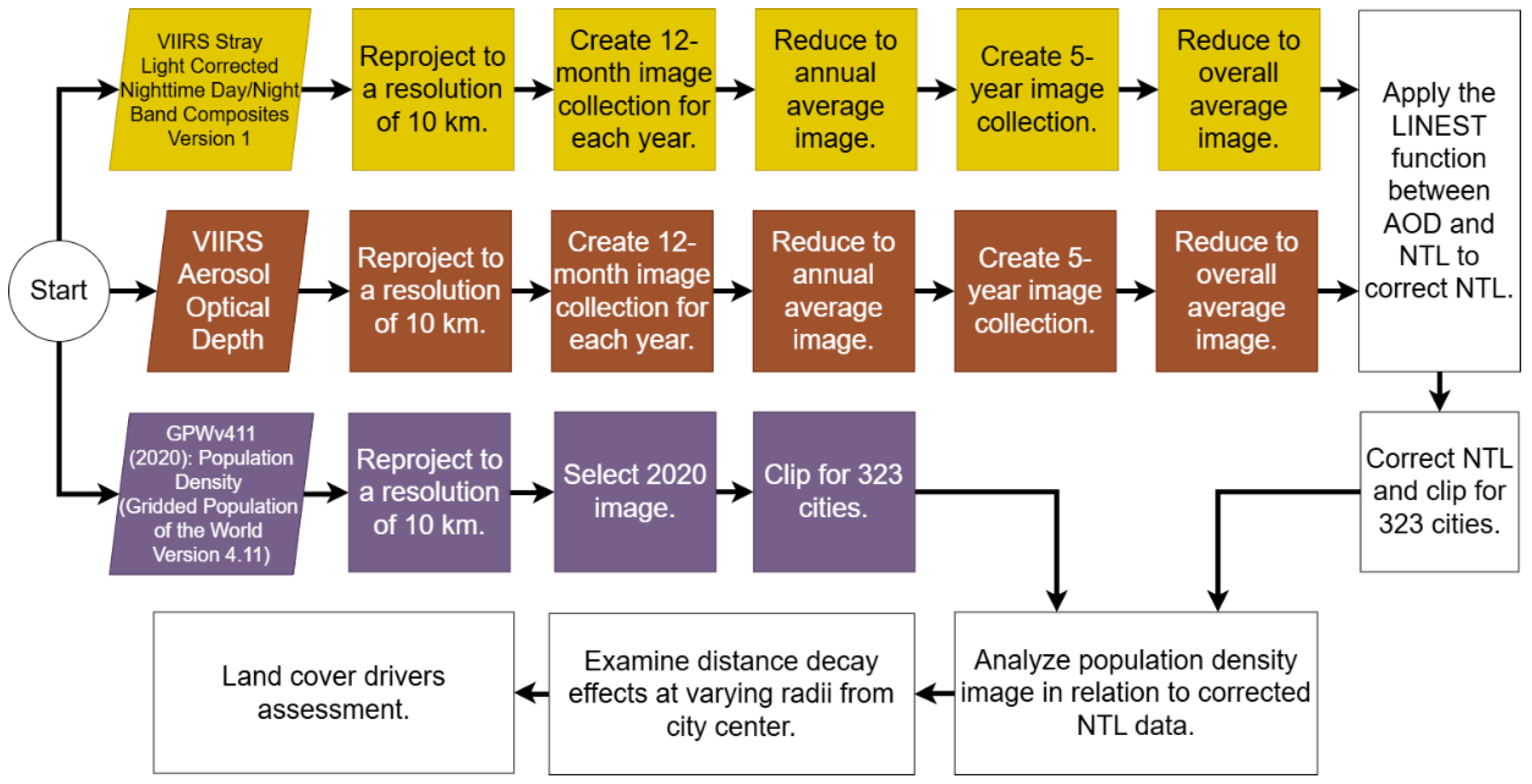
2. Materials and Methods
2.1. World Cities
The list of 323 cities was obtained from the World Cities dataset available online through the ArcGIS Hub. The full dataset contains over two thousand cities around the world, each represented by a point feature at the city’s approximate geographic center. This dataset was downloaded from the online ArcGIS Hub, uploaded to GEE (v0.1.383), and filtered to 323 cities located in South/Southeast Asia. All mentions of the centers of cities in this paper refer to the location of a city’s corresponding point in this dataset; as such, these points were also the centers of all circular radii. The full list of cities and some associated data can be found in Appendix A.
2.2. VIIRS Nightttime Lights
We used the nighttime lights product that is derived from monthly average radiance composite images using nighttime data from the Visible Infrared Imaging Radiometer Suite (VIIRS). VIIRS has 22 channels, with a nominal spatial resolution of 375 m in the 5 imagery bands (I-bands) and 750 m in 16 moderate-resolution bands (M-bands), covering a spectral range from 0.412 μm to 12.01 μm. The VIIRS instrument includes two distinct sets of multi-spectral channels, offering complete worldwide coverage at nominal resolutions of 375 m and 750 m every 12 h or less, depending on the latitude. The VIIRS low-light channel, also called as day–night band or DNB, provides a nighttime image of reflected and emitted light, but with the resolution of day-time visible imagery. In the VIIRS nighttime light product, cloud cover is determined using the VIIRS Cloud Mask product (VCM). This product is an alternative configuration of the VIIRS DNB using a procedure to correct for stray light. The correction procedure extends visible areas closer to the poles and improves dynamic range [26]. We temporally composited and averaged the nightlight images for five years from 2012 to 2020 to avoid further contamination for the clouds and also to match the population data year. In the nightlight product, the electric lights are the brightest and most constant light sources and are the most concentrated in urban areas. As a result, the intensity of the lights within a given region is usable as a proxy for the extent of urbanization therein. Furthermore, while using the NTL data, we averaged the NTL data over different months and years across larger spatial areas with varying city radii, effectively smoothing out local variations, including any potential zenith angle effects.
2.3. VIIRS Aerosol Optical Depth (AOD)
Before the nighttime light (NTL) data could be used, it needed to be corrected to account for the brightness-dampening effects of air pollution. In general, aerosol optical depth (AOD) tends to reduce NTL intensity due to the absorption and scattering of artificial light by aerosols in the atmosphere. When aerosol concentrations are high, light emitted from urban or industrial sources is scattered or absorbed before reaching satellite sensors, leading to a reduction in the amount of light detected, and thus a decrease in NTL intensity. The correction was made using AOD data from the SUOMI-NPP VIIRS AOD product, provided by NOAA’s National Environmental Satellite, Data, and Information Service. Initially, the AOD data were a collection of netCDF images, with each composite representing a single month’s observations. These netCDF files were converted to GeoTIFF format, uploaded to Google Earth Engine (GEE), and processed in a similar manner to the NTL data. The remainder of the correction process was performed outside of GEE. For each city, we processed the average NTL and AOD data by first developing a linear regression model. Using the measured NTL brightness as f(x), the slope (Beta) as m, and the measured AOD as x, we solved for the y-intercept (b), which represents the true NTL brightness—the value that would have been recorded if aerosols had not blocked the light. Using this model, we subtracted the estimated AOD influence from the original nightlight data to obtain corrected values, represented by the equation: Corrected NTL = Original NTL—B × AOD. Furthermore, while analyzing 323 cities, we observed that larger cities tended to be more polluted and thus had a higher AOD compared to smaller cities. The scatterplots of AOD and NTL brightness revealed a dense cluster of cities with relatively low values for both variables, distinctly separated from a more dispersed pattern at higher values. To address this, we applied an iterative correction rather than a one-time adjustment based on the overall slope of the AOD-NTL relationship. This approach minimized the risk of overcorrection and ensured consistency in NTL brightness values across all cities. The difference between the corrected versus uncorrected NTL data for different buffer radii are shown below (Figure 2).
Figure 2.
The average nighttime light brightness of the corrected cities at different buffer sizes, before and after AOD correction was applied.
2.4. Gridded Population of the World (GPW)
It is a widely utilized dataset in urbanization and demographic research for understanding the population characteristics in different cities [39]. The data provide spatially explicit information on human population distribution across the globe at a fine resolution. GPW 4.11 incorporates census data, satellite imagery, and other geospatial datasets to estimate population distribution, making it valuable for understanding urban sprawl and its impacts on urban areas. The GPW (4.11) dataset consist of estimates of human population density (number of persons per square kilometer) based on counts for the years of 2000, 2005, 2010, 2015, and 2020. The dataset is based on a proportional allocation gridding algorithm that utilizes approximately 13.5 million national and sub-national administrative units to assign population counts to 30 arc-second grid cells. The population density rasters were created by dividing the population count raster for a given target year by the land area raster [39]. The data files were produced as global rasters at 30 arc-second (~1 km at the equator) resolution and also aggregated at different resolutions (2.5 arc-minute, 15 arc-minute, 30 arc-minute, and 1-degree rasters) for faster processing. In this study, we used the year 2000 GPW (4.11) product.
We also used the World Cities location files, a set of point features representing thousands of cities worldwide, obtained from Esri’s ArcGIS hub. For this project, the dataset was filtered to only the cities located in South/Southeast Asia.
We processed the aforementioned datasets, namely nighttime lights and population data, using Google Earth Engine (GEE). Initially, we employed filterBounds to exclude images that did not cover any part of South or Southeast Asian countries from the collection. Subsequently, the collection was reprojected to a resolution of 10 km, the minimum resolution at which image reduction and exportation tasks could be successfully performed over areas of these countries’ size and shape. Using a filterDate loop, we segregated the collection into multiple smaller collections, each containing images captured during a single month, and created a 12-month image compilation spanning five years from 2019 to 2023. To mitigate cloud interference, we averaged the data over these five years. Following this, the image data was clipped to the boundaries of various regions of interest, specifically circles of various sizes surrounding cities in South and Southeast Asia, before being exported to spreadsheets for further analysis. The 2020 GPW data corresponding to nighttime lights required minimal additional processing beyond filterBounds, reprojection to 10 km, and exporting.
2.5. MODIS Land Cover
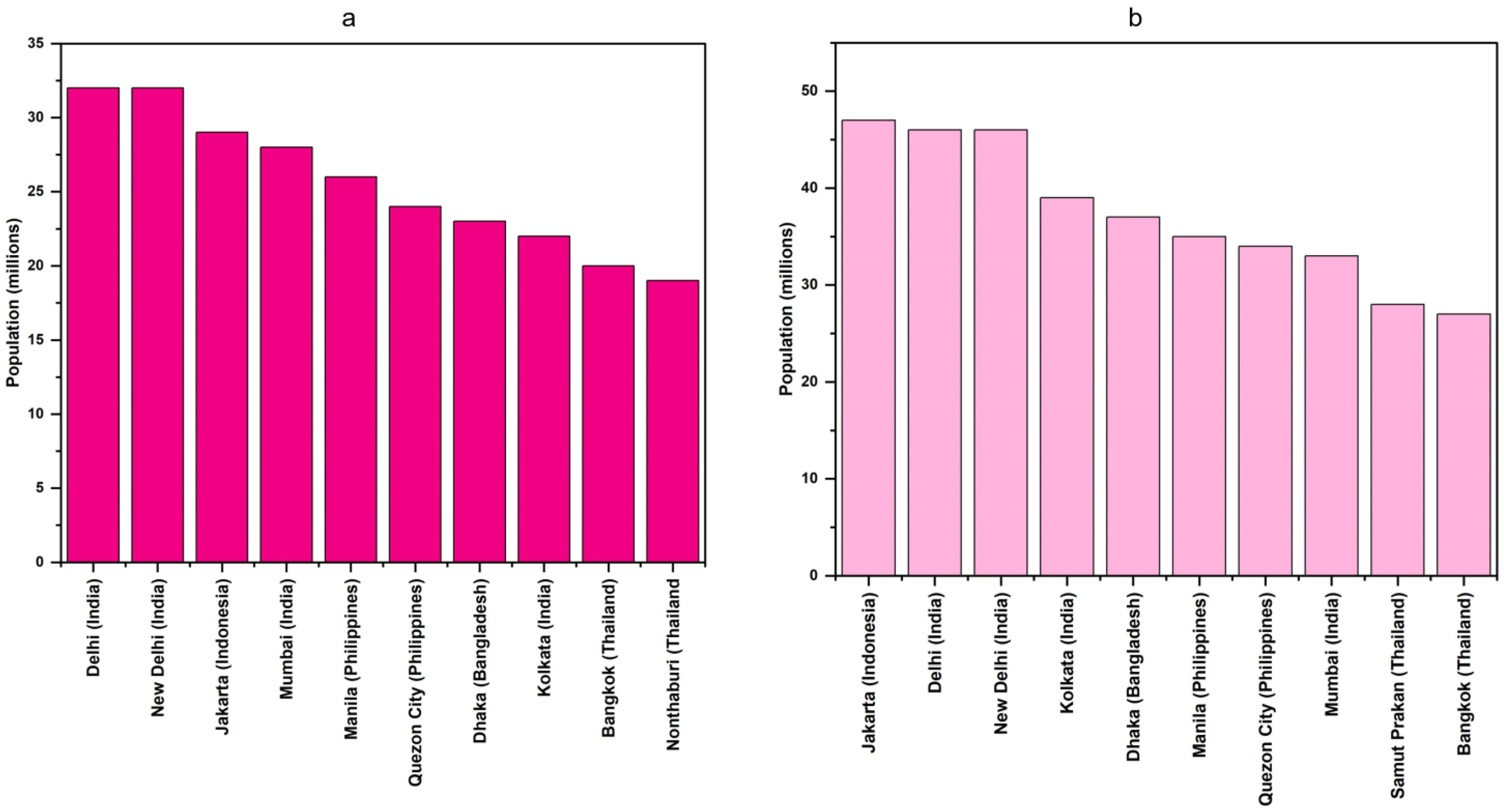
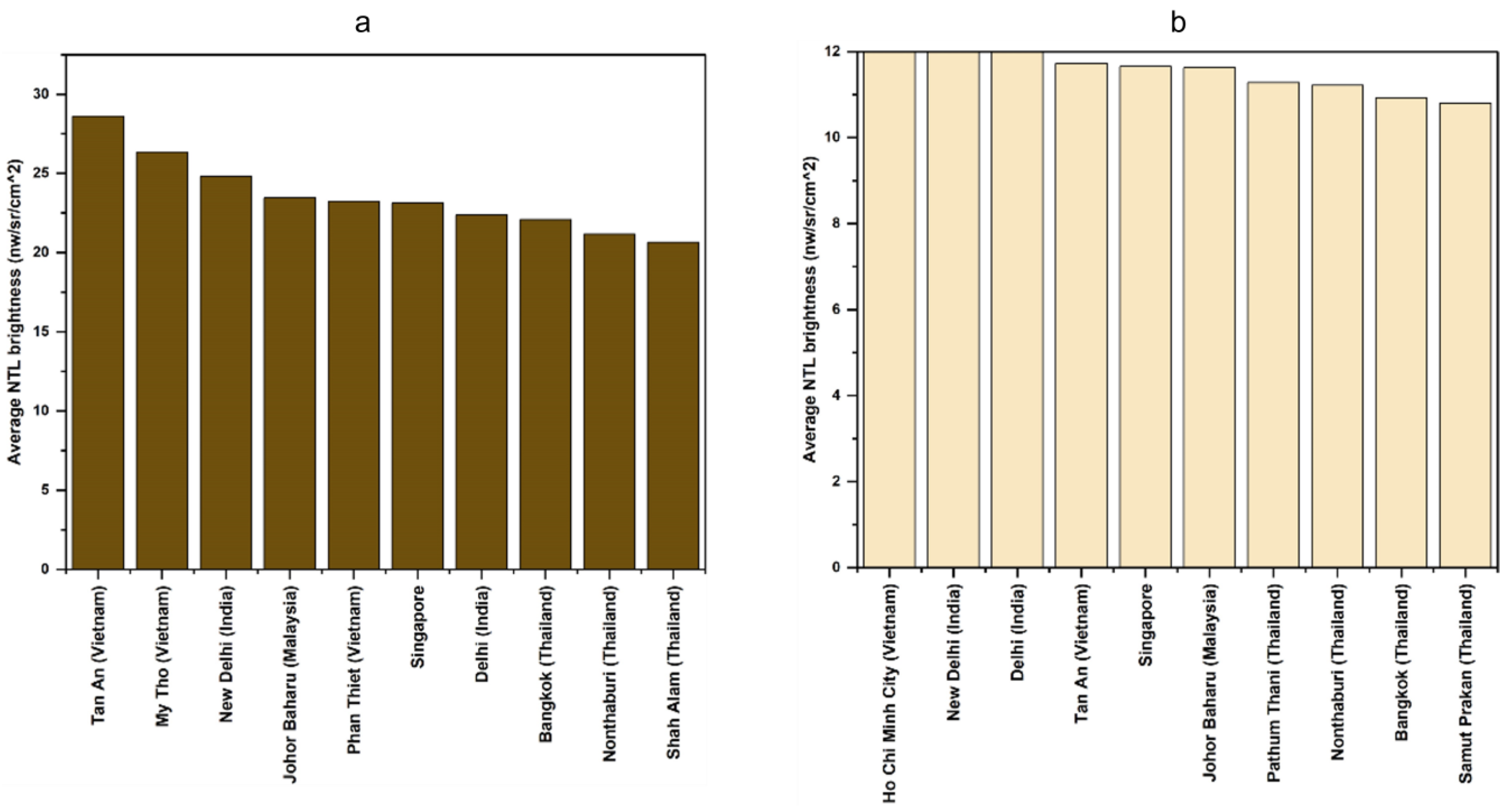
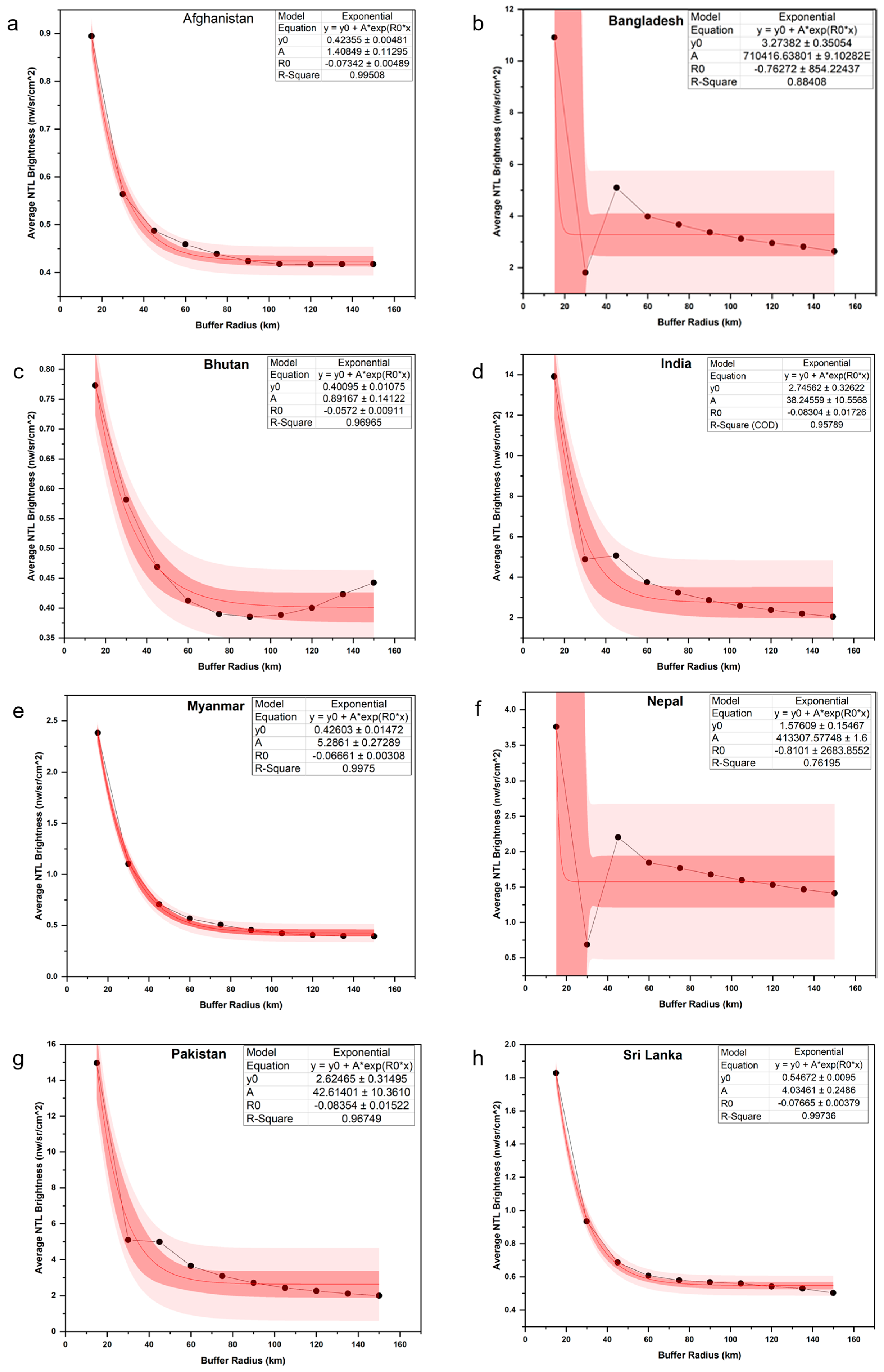
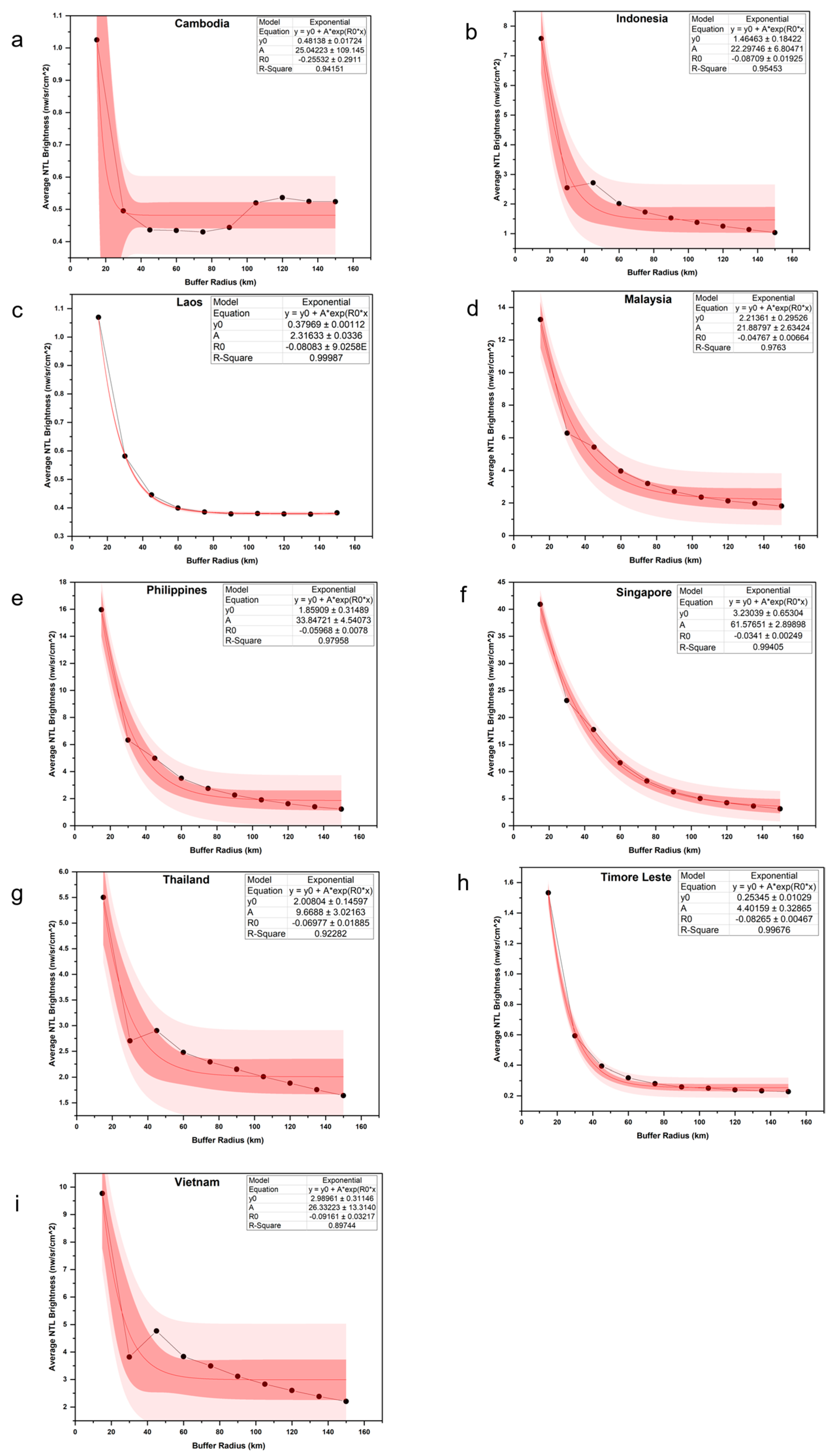
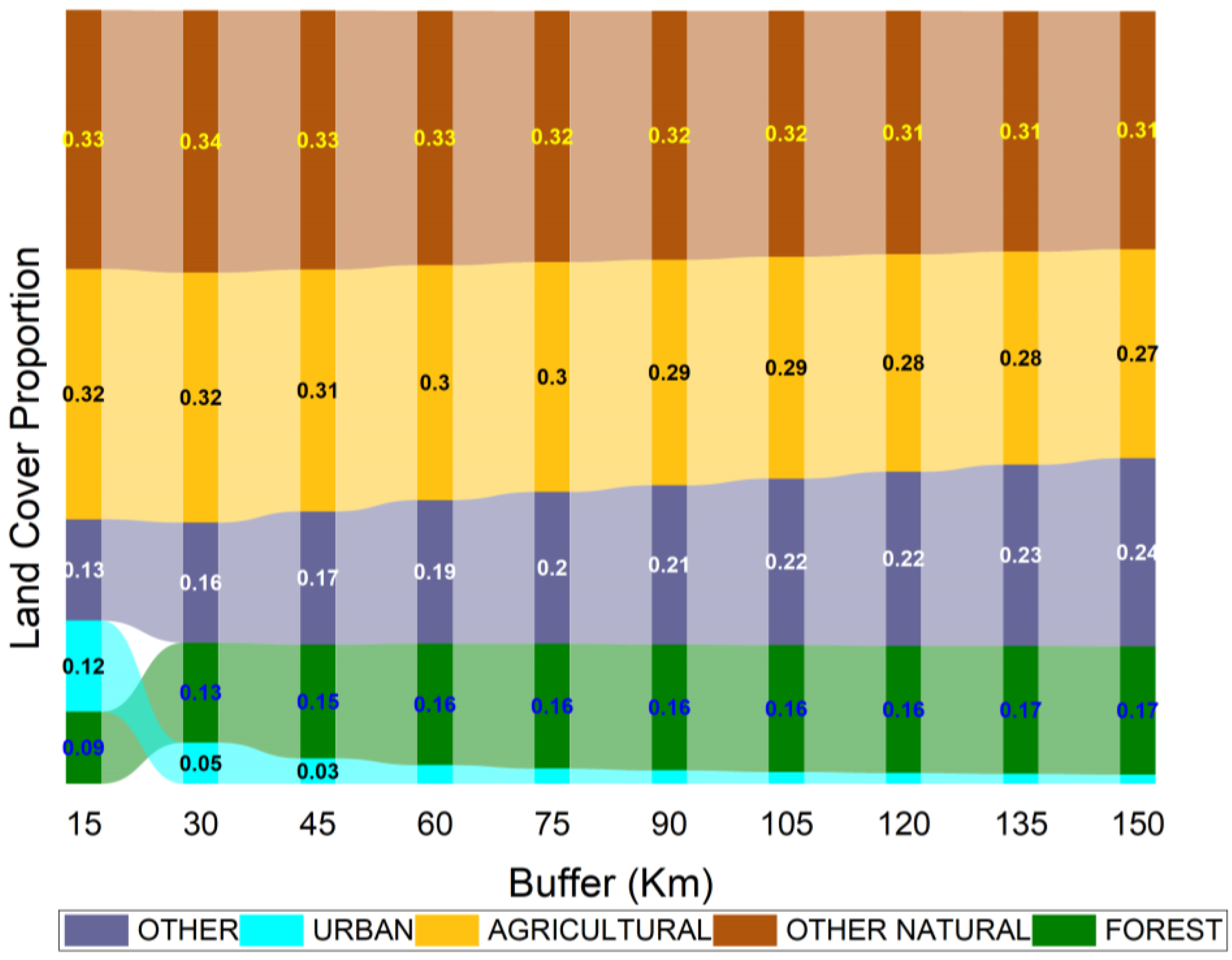
To assess the drivers of NTL variations, we used MODIS land cover data (MCD12Q1) at different buffer radii around 323 cities to infer its influence. This was achieved by reclassifying the MODIS land cover image into five land cover (LC) categories from the original 21 classes, following the International Geosphere-Biosphere Programme (IGBP) classification. The categories were: forest (LC types 1–5, including all evergreen, deciduous, broadleaf, needleleaf, and mixed forests), other natural vegetation (LC types 6–11, including shrublands, savannas, grasslands, and wetlands), agricultural area (LC types 12 and 14, representing cropland and cropland/natural vegetation mosaics), urban (LC type 13), and other (LC types 15, 16, and 17, representing permanent snow/ice, barren land, and open water, respectively). All processing was conducted in Google Earth Engine (GEE). Specifically, using the Image.reduceToVectors, Feature.geometry, and Geometry.area functions, we calculated the percentage of each buffer area occupied by each land cover type, assigned it as a property to a feature, and exported the data. The flowchart of the methodology followed in this study is shown in Figure 3.
Figure 3.
Flowchart summarizing the data processing workflow.
With these datasets, we investigated the central question focusing on the distance-decay effect, which examines the diminishing intensity of nighttime lights (a proxy for urbanization) and population density as one moves away from the city center across many cities in South and Southeast Asia. By assessing the correlation between nighttime light intensity and population density across varying radii, we characterized how this correlation changes with the distance from the city center. Our hypothesis posited that, nearer to the city center, both nighttime light intensity and population density would be higher, indicative of the core urban area. As the radii size expanded, suggesting movement towards suburban and peri-urban regions affected by urban sprawl, the correlation between nighttime light intensity and population density exhibited fluctuations, reflecting diverse levels of urban development and spatial patterns among different cities. Additionally, we anticipated regional distinctions; for instance, cities in South Asia would differ from those in Southeast Asia due to varying population sizes and infrastructure development levels. These findings highlight the significance of employing dynamic spatial metrics, such as variable distance from the city center, to accurately capture the intricacies of urbanization and its spatial extent. Such insights are invaluable for informing urban planning strategies and policy formulation in rapidly growing regions.
3. Results
We studied a total of 323 cities across 17 countries (Figure 1). According to UN population figures from 2018, the cities of Delhi, Mumbai, Dhaka, Karachi, Kolkata, Manila, Lahore, Bangalore, Jakarta, Chennai, and Bangkok are classified as megacities, meaning they have 10 million or more people.
Figure 4 shows the top ten most populous cities in South and Southeast Asia, as calculated within 30 km (Figure 4a) and 60 km (Figure 4b) radii from the city center. At both radii, the top three cities included Delhi (India), New Delhi (India), and Jakarta (Indonesia), followed by others.
Figure 4.
The top ten most populous cities in South and Southeast Asian countries within 30 km (a) and 60 km (b) radii from the city center.
Figure 5 lists the top ten cities by nighttime light (NTL) brightness in South and Southeast Asian countries as calculated at 30 km (Figure 5a) and 60 km (Figure 5b) radii from the city center. At a 30 km radius, the brightest cities included Tan An (Vietnam), My Tho (Vietnam), and New Delhi (India), while at a 60 km radius, the brightest cities were Ho Chi Minh City (Vietnam), New Delhi (India), and Delhi (India), followed by others.
Figure 5.
Top ten cities in nighttime light brightness in South and Southeast Asian countries at 30 (a) and 60 km (b) radii from the city center.
Figure 6 highlights the landscape heterogeneity in different cities of South and Southeast Asia within a 60 km radius from the city center. Significant variations in city size and green cover are evident. For example, desert cities like Kabul (Figure 6a) or mountainous ones like Thimphu (Figure 6b) are typically much smaller than other cities due to the limitations imposed by the surrounding harsh terrain. Additionally, an uneven distribution of green space can be seen in Delhi (Figure 6c), Dhaka (Figure 6d), and Ho Chi Minh City (Figure 6e). The cities of Singapore (Figure 6f), Kuala Lumpur (Figure 6g), and Bangkok (Figure 6h) border the ocean within a 60 km radius. Consequently, we predicted that changes in radius from the city center have extreme and erratic effects on NTL-population correlation coefficients. Thus, we compared several different radii, starting with a radius of 15 km and increasing in 15 km steps until reaching the largest size of 150 km. Nighttime light brightness variations with varying radius from the city center in different capital cities of South and Southeast Asia are shown in Figure 7. Delhi (India), Singapore, and Bangkok (Thailand) had the highest NTL brightness, while Dili (Timor-Leste) and Thimphu (Bhutan) had the least NTL brightness. As expected, the average nighttime light (NTL) brightness within the different radii tended to vary inversely with its size. In most cases, the values steeply dropped off for the first few steps, and then settled into a much more gradual and consistent decrease around the 45 km or 60 km mark. This result suggests that such radii are the minimum at which the largest metropolitan areas are fully encompassed. Some discrepancies where NTL increases away from the city centers were noted. The NTL in such cases be attributed to new industrial zones, business parks, or satellite cities that are often developed on the outskirts of large metropolitan areas. Additionally, large airports are typically located outside city centers and require significant lighting for runways, terminals, and related facilities. This concentrated lighting around airports is detectable by NTL sensors, leading to increased brightness at a distance from the city. Similarly, logistics hubs, truck stops, and transport centers can also contribute to NTL increases. In some cases, large-scale agricultural operations generate substantial nighttime light, even in rural areas.
Figure 6.
Landscape heterogeneity in different cities of South/Southeast Asia with a 60 km radius from the city center. Significant variations in city size and green cover are evident. The mountainous cities of Kabul (a) and Thimpu (b) are typically much smaller than the other cities, due to the external limitations of the surrounding harsh terrain. An uneven distribution of green space can be seen in Delhi (c), Dhaka (d), and Ho Chi Minh City (e). The cities of Singapore (f), Kuala Lumpur (g), and Bangkok (h) border the ocean within a 60 km radius.
Figure 7.
Nighttime light brightness variations with buffer radius from the city center in different capital cities of South/Southeast Asia as retrieved from the VIIRS instrument on the Suomi-NPP satellite. New Delhi, Singapore, and Bangkok had the highest NTL brightness, and Timor-Leste and Bhutan had the lowest NTL brightness.
We also conducted a country-wide analysis of nighttime light brightness variations in different cities across both South (Figure 8) and Southeast Asia (Figure 9). Data from various cities in respective countries were aggregated. In South Asia, a relatively higher brightness was found in India and Pakistan compared to other countries. In Southeast Asia, relatively higher brightness was observed in Singapore, the Philippines, and Malaysia compared to other countries. A clear negative exponential decrease can be observed in nighttime light brightness with the increase in the distance from the city center. The model parameters are also provided in the individual figures.
Figure 8.
(a–h) Nighttime light brightness variations from the city center in different countries of South Asia, as retrieved from the VIIRS Suomi-NPP. The original data are shown as a black dotted line. A relatively higher brightness can be observed for India (d) and Pakistan (g) compared to other countries. A clear negative exponential relationship can be observed in the nighttime light brightness with the increase in the distance from the city center (fitted line in dark red). In the equation, * denotes multiplication. The plot also shows confidence (dark red) and prediction (light red) bands of the data with 95% confidence.
Figure 9.
(a–i) Nighttime light brightness variations with buffer radius from the city center in different countries of Southeast Asia, as retrieved from the VIIRS Suomi-NPP. The original data are shown as a black dotted line. Relatively higher brightness can be observed in Malaysia (d), the Philippines (e), and Singapore (f) compared to other countries. A clear negative exponential relationship can be seen in the nighttime light brightness with the increase in the distance from the city center (fitted line in dark red). In the equation, * denotes multiplication. The plot also shows confidence (dark red) and prediction (light red) bands of the data with 95% confidence.
Figure 10 shows NTL brightness versus total population correlations at different radii from the city center for all South and Southeast Asian countries. As anticipated, the strength of the correlation (R2) between NTL and population varied with radii. When looking at individual countries, there was little consistency regarding which radius produced the strongest correlations; some countries attained their maximum R2 at 30 km or 45 km, while others reached it at much larger or smaller sizes. For instance, India’s R2 was strongest at 45 km, which was the same radius at which Afghanistan’s R2 was weakest. The results became clearer when analyzed across all 323 cities collectively. Of the resulting scatterplots (Figure 10), R2 increased from 15 km (Figure 10a), peaked at a 105 km (Figure 10d) radius, and gradually declined as the size continued to increase. To confirm the validity of the 105 km radius, ArcGIS Pro 3.2.0 was used for visual comparison. Circles of varying sizes were drawn around select elements from the World Cities dataset, mimicking the process performed in Google Earth Engine. These circles were displayed against the Earthstar Geographics Satellite Imagery base map, where urban developed areas are visually distinguishable from their natural surroundings.
Figure 10.
(a–j) Nighttime light brightness versus total population correlations at different buffer radii from the city center for all South/Southeast Asian countries. The original data are shown as blue dots and the linear fit as a red line. A relatively higher correlation can be found at a 60 km radius. The plot also shows confidence (light red) and prediction (light green) bands of the data with 95% confidence.
As anticipated and supported by the results, the 105 km radius was large enough to encompass the densest areas of visible development in all major regional cities. These results were also compared with the World Urban Areas dataset to ensure that the formal boundaries of all cities fit within the radii; they universally did, as most cities’ formal boundaries are substantially smaller than the full metropolitan area (see Figure 6). From these findings, we concluded that 105 km is the ideal radii when processing raster data over a large number of cities in the South and Southeast Asia region. However, the ideal radius size might vary for more specific applications. Although the 105 km radius is the smallest that can encircle the largest cities (Delhi, Manila, and Jakarta), many countries in the region—especially those where urban growth is limited by harsh terrain such as deserts (Afghanistan) or mountains (Bhutan, Nepal)—do not have cities of such large sizes. In such countries, the trend of decreasing average NTL brightness with the increase in size stabilizes before reaching the 105 km mark, often at 45 km or even 30 km.
We also assessed the land cover variations at different buffer radii. The NTL variations mentioned above were assessed in relation to MODIS land cover data. As expected, the percentage of urban areas within a buffer radii decreases rapidly as the buffer expands (Figure 11). In all countries, the urban percentage is the highest at 15 km, but it shrinks rapidly at 30 km and then dwindles to a barely visible line on the graph as the proportions of other land cover types increase. In most countries, most non-urban areas consist of agricultural land or non-forest types of natural vegetation. Coastal countries show a significant portion of “other” land cover types, primarily ocean; Afghanistan also has a large amount of land in the “other” category, which is mostly desert. Bhutan’s urban area is minimal with “other” areas dominating, such as barren slopes and snow-capped mountains.
Figure 11.
Changing proportion of land cover types as buffer radius increases. The forest includes all evergreen, deciduous, broadleaf, needle leaf, and mixed forests; other natural vegetation includes shrublands, savannahs, grasslands, and wetlands; agricultural area designates cropland and mosaics of cropland and natural vegetation; urban refers to built areas; and other denotes permanent snow/ice, barren land, and/or open water.
4. Discussion
Urbanization in South and Southeast Asia is a dynamic and complex phenomenon driven by rapid population growth and economic development [2,5,9]. Our study of 323 cities across 17 countries reveals notable patterns and challenges related to urban growth, infrastructure, and sustainability. Specific to urbanization and population dynamics, the distinction between mega-cities and other large urban areas is evident in this region. Cities like Delhi, Mumbai, Dhaka, and Jakarta, which surpass 10 million people, face unique challenges and opportunities. These mega-cities experience intense pressure on infrastructure, resources, and services due to their size and density. This urban pressure often results in significant variations in city size, green cover, and nighttime light (NTL) brightness. For example, cities like Delhi and Jakarta exhibit high NTL brightness and extensive urban areas, reflecting their substantial economic and social activities. Also, the cities with significant variations in green space, such as Delhi, Dhaka, and Ho Chi Minh City, can have an impact on urban livability. Effective urban planning policies should prioritize the integration of green spaces within urban areas to enhance the quality of life and environmental sustainability [3,8]. The NTL data can provide useful information on the spatial patterns of brightness indicating various levels of urbanization characteristics and can aid in urban planning and managing urban growth [12,28]. Our analysis reveals that cities like Delhi and Bangkok, with high NTL brightness, have more developed infrastructure to support their large populations. Conversely, cities in mountainous regions, such as Kabul and Thimphu, face external limitations due to their terrain, which constrains infrastructure development and urban expansion. This disparity highlights the need for tailored infrastructure solutions that consider geographical and environmental constraints.
Sustainability remains a significant challenge in rapidly urbanizing regions, not just within core urban areas but also extending to peri-urban and rural areas [5]. Peri-urban areas especially often face unique sustainability challenges. These areas are characterized by their proximity to major urban centers and typically experience rapid changes in land use and development pressures. The negative exponential relationship observed in NTL brightness with increasing distance from the city center can also provide information on the peri-urban regions. As cities expand outward, peri-urban areas can become hotspots for urban sprawl, leading to several issues. For example, peri-urban areas often experience a mismatch between rapid population growth and the availability of infrastructure and services. The demand for housing, transportation, and utilities can outpace the development of necessary infrastructure, leading to inadequate provision of services and reduced quality of life. Similarly, the expansion of urban areas into peri-urban regions can lead to significant environmental degradation. This includes the loss of agricultural land, increased pollution, and disruption of local ecosystems. Sustainable planning practices are essential to mitigate these impacts, focusing on integrating green spaces, managing land use efficiently, and protecting natural resources. For the same, the data on NTL can be a useful indicator of urbanization including peri-urban development. Our findings also highlight that 105 km radius from the city center is ideal for characterizing the densest areas of urban development. This radius captures the full extent of major metropolitan areas while providing a comprehensive view of urban dynamics. However, the ideal radius may vary based on specific city characteristics and applications. For instance, in countries with harsh terrains, such as Afghanistan and Bhutan, smaller radii sizes to study urbanization patterns may be more appropriate due to the limitations imposed by the landscape. Thus, effective policies should also consider the urban morphology and neighboring landscape characteristics to address the diverse needs of urban areas, considering their unique challenges and opportunities. Sustainable urban development strategies, coupled with tailored infrastructure solutions, are essential for fostering resilient and livable cities in this rapidly evolving region.
5. Conclusions
Our study of 323 cities across 17 South and Southeast Asian countries reveals key patterns in urbanization as evident from satellite-derived nighttime light data. Nighttime light brightness variations with radii from the city center in different capital cities of South and Southeast Asia varied inversely with their size. In most cases, the values steeply dropped off for the first few steps, and then settled into a much more gradual and consistent decrease around the 105 km mark. This result suggests that such radii are the minimum at which the largest metropolitan areas are fully encompassed in South/Southeast Asia. Mega-cities like Delhi, Mumbai, and Jakarta face significant infrastructure and resource pressures, while mountainous and desert cities such as Kabul and Thimphu struggle with development constraints due to the surrounding terrain. Variations in green space, evident in cities like Delhi and Dhaka, highlight the need for better urban planning to enhance livability and environmental sustainability. Peri-urban and rural areas, which are transitioning from rural to urban settings, face unique challenges including inadequate infrastructure and environmental degradation. The negative exponential relationship between nighttime light (NTL) brightness and radius from the city center captured in this study indicates that peri-urban regions are increasingly affected by urban sprawl as cities expand. Our findings suggest that a 105 km radius effectively captures the extent of major metropolitan areas. However, the radius size should be adjusted based on the study area to account for specific city characteristics and environmental constraints. Sustainable urban development requires tailored solutions to address local challenges and foster resilient, livable cities in this rapidly evolving region.
Author Contributions
Conceptualization, G.M. and K.P.V.; methodology, G.M. and K.P.V.; software, G.M. and K.P.V.; validation, G.M. and K.P.V.; formal analysis, G.M. and K.P.V.; investigation, G.M. and K.P.V.; resources, K.P.V.; data curation, G.M.; writing—original draft preparation, K.P.V.; writing—review and editing, G.M. and K.P.V.; visualization, K.P.V.; supervision, K.P.V.; project administration, K.P.V.; funding acquisition, K.P.V. All authors have read and agreed to the published version of the manuscript.
Funding
This research was funded by NASA Land Cover/Land Use Change Program (Fund code: SCEX22023D under the South/Southeast Asia Research Initiative (SARI), including the APC.
Data Availability Statement
The original contributions presented in the study are included in the article, further inquiries can be directed to the corresponding author.
Conflicts of Interest
The authors declare no conflicts of interest. The funders had no role in the design of the study; in the collection, analyses, or interpretation of data; in the writing of the manuscript; or in the decision to publish the results.
Appendix A
This table contains the full list of 323 cities and their nighttime light brightness values, calculated over a 105-km-radius circular buffer.
| City | Country | Corrected NTL—Average of 5 Years (Nanowatts/Steradian/cm2) |
| Asadabad | Afghanistan | 0.501834863 |
| Aybak | Afghanistan | 0.426534121 |
| Baghlan | Afghanistan | 0.397758707 |
| Bamian | Afghanistan | 0.361914916 |
| Baraki Barak | Afghanistan | 0.462130676 |
| Chaghcharan | Afghanistan | 0.350743321 |
| Charikar | Afghanistan | 0.535865428 |
| Farah | Afghanistan | 0.31904953 |
| Feyzabad | Afghanistan | 0.397201593 |
| Gardez | Afghanistan | 0.399662902 |
| Ghazni | Afghanistan | 0.355678697 |
| Herat | Afghanistan | 0.368470734 |
| Jalabad | Afghanistan | 0.425522793 |
| Kabul | Afghanistan | 0.533968339 |
| Kandahar | Afghanistan | 0.378633147 |
| Konduz | Afghanistan | 0.431714003 |
| Lashkar Gah | Afghanistan | 0.343657309 |
| Mahmud-E Eraqi | Afghanistan | 0.536301135 |
| Mayda Shahr | Afghanistan | 0.530743884 |
| Mazar-E Sharif | Afghanistan | 0.495839474 |
| Mehtar Lam | Afghanistan | 0.537215143 |
| Meymaneh | Afghanistan | 0.359015844 |
| Qal eh-ye | Afghanistan | 0.359184324 |
| Qalat | Afghanistan | 0.329947827 |
| Sheberghan | Afghanistan | 0.393649087 |
| Taloqan | Afghanistan | 0.405271221 |
| Tarin Kowt | Afghanistan | 0.330927979 |
| Zaranj | Afghanistan | 0.505832693 |
| Zareh Sharan | Afghanistan | 0.337497598 |
| Barisal | Bangladesh | 2.994081559 |
| Chittagong | Bangladesh | 2.571990951 |
| Dhaka | Bangladesh | 3.633371151 |
| Khulna | Bangladesh | 3.110419123 |
| Rajshahi | Bangladesh | 3.319693888 |
| Paro | Bhutan | 0.416465136 |
| Punakha | Bhutan | 0.360700381 |
| Thimphu | Bhutan | 0.395505629 |
| Wangdue Prodrang | Bhutan | 0.38189671 |
| Batdambang | Cambodia | 0.34695648 |
| Kampong Cham | Cambodia | 0.513905924 |
| Kampong Chnang | Cambodia | 0.473379942 |
| Kampong Spoe | Cambodia | 0.517357304 |
| Kampong Thum | Cambodia | 0.265932348 |
| Kampot | Cambodia | 0.506196023 |
| Kracheh | Cambodia | 0.296868465 |
| Krong Kaoh Kong | Cambodia | 0.321757985 |
| Lumphat | Cambodia | 0.277420591 |
| Phnom Penh | Cambodia | 0.527623932 |
| Phnum Tbeng Meanchey | Cambodia | 0.270374375 |
| Pouthisat | Cambodia | 0.288849628 |
| Prey Veng | Cambodia | 0.616284759 |
| Senmonorom | Cambodia | 0.409964171 |
| Siemreab | Cambodia | 0.286193981 |
| Stoeng Treng | Cambodia | 0.261870197 |
| Svay Rieng | Cambodia | 2.555274761 |
| Takev | Cambodia | 0.623874891 |
| Agartala | India | 3.332949371 |
| Ahmadabad | India | 3.526194786 |
| Aizawl | India | 0.353174233 |
| Amritsar | India | 4.371004931 |
| Bangalore | India | 3.567667549 |
| Bhopal | India | 2.700780431 |
| Bhubaneshwar | India | 3.210367798 |
| Chandigarh | India | 3.543067681 |
| Chennai | India | 2.84864068 |
| Cochin | India | 2.395581693 |
| Daman | India | 2.849545801 |
| Delhi | India | 6.684726443 |
| Dispur | India | 2.521181796 |
| Gandhinagar | India | 3.398419827 |
| Gangtok | India | 0.555443125 |
| Hyderabad | India | 3.68406559 |
| Imphal | India | 0.423221228 |
| Itanagar | India | 0.478727645 |
| Jaipur | India | 2.889972411 |
| Kanpur | India | 3.875339078 |
| Kavaratti | India | 0.231517573 |
| Kohima | India | 0.506387392 |
| Kolkata | India | 4.47528418 |
| Lucknow | India | 4.020021702 |
| Madurai | India | 0.858952331 |
| Mangalore | India | 2.186418994 |
| Mumbai | India | 3.553312207 |
| Nagpur | India | 2.733629968 |
| New Delhi | India | 6.627792327 |
| Panaji | India | 2.298713841 |
| Patna | India | 4.570497286 |
| Pondicherry | India | 0.886790759 |
| Port Blair | India | 0.21553754 |
| Pune | India | 3.323350205 |
| Shillong | India | 0.609181188 |
| Silvassa | India | 2.792435543 |
| Simla | India | 1.233389943 |
| Srinagar | India | 0.626480315 |
| Trivandrum | India | 0.666754684 |
| Varanasi | India | 3.716690848 |
| Vishakhapatnam | India | 2.330531638 |
| Ambon | Indonesia | 0.225208333 |
| Balikpapan | Indonesia | 0.611580981 |
| Banda Aceh | Indonesia | 0.27850532 |
| Bandjermasin | Indonesia | 0.423258184 |
| Bandung | Indonesia | 3.617200196 |
| Bengkulu | Indonesia | 0.278085185 |
| Denpasar | Indonesia | 0.492534159 |
| Jakarta | Indonesia | 4.606163432 |
| Jambi | Indonesia | 2.63107119 |
| Jayapura | Indonesia | 0.22897585 |
| Kendari | Indonesia | 0.302029248 |
| Kupang | Indonesia | 0.266981015 |
| Makassar | Indonesia | 0.565833817 |
| Manado | Indonesia | 0.300815963 |
| Mataram | Indonesia | 0.4886469 |
| Medan | Indonesia | 2.520011727 |
| Padang | Indonesia | 0.391949054 |
| Palangkaraya | Indonesia | 1.99679264 |
| Palembang | Indonesia | 2.580498976 |
| Palu | Indonesia | 0.257447713 |
| Pekanbaru | Indonesia | 2.813161692 |
| Pontianak | Indonesia | 0.428487782 |
| Samarinda | Indonesia | 0.710672472 |
| Semarang | Indonesia | 2.975540109 |
| Surabaja | Indonesia | 3.602080552 |
| Tanjungkarang-Telukbetung | Indonesia | 2.418158958 |
| Yogyakarta | Indonesia | 1.254816366 |
| Attapu | Laos | 0.264930241 |
| Champasak | Laos | 0.33278625 |
| Louang Namtha | Laos | 0.317338021 |
| Louangphrabang | Laos | 0.306698823 |
| Muang Khammouan | Laos | 0.521855442 |
| Muang Xaignabouri | Laos | 0.353102191 |
| Phongsali | Laos | 0.308264924 |
| Saravan | Laos | 0.268980707 |
| Savannakhet | Laos | 0.627448988 |
| Vientiane | Laos | 0.669892607 |
| Xam Nua | Laos | 0.283144296 |
| Xiangkhoang | Laos | 0.304311679 |
| Alor Setar | Malaysia | 1.486407129 |
| Ipoh | Malaysia | 2.779358307 |
| Johor Baharu | Malaysia | 5.218487253 |
| Kangar | Malaysia | 1.121721982 |
| Kemaman Harbor | Malaysia | 2.161516783 |
| Kota Baharu | Malaysia | 0.690158314 |
| Kota Kinabalu | Malaysia | 0.568632301 |
| Kuala Lipis | Malaysia | 0.672954462 |
| Kuala Lumpur | Malaysia | 4.794306115 |
| Kuala Terengganu | Malaysia | 0.809582811 |
| Kuantan New Port | Malaysia | 0.916700056 |
| Kuching | Malaysia | 0.490305881 |
| Melaka | Malaysia | 3.551569873 |
| Pinang | Malaysia | 2.633249759 |
| Seremban | Malaysia | 5.118857682 |
| Shah Alam | Malaysia | 4.672258961 |
| Bassein | Myanmar | 0.28329036 |
| Haka | Myanmar | 0.321703914 |
| Loikaw | Myanmar | 0.351829397 |
| Magway | Myanmar | 0.351325631 |
| Mandalay | Myanmar | 0.598226044 |
| Moulmein | Myanmar | 0.319032164 |
| Myitkyina | Myanmar | 0.301426637 |
| Nay Pyi Taw | Myanmar | 0.436893129 |
| Pa-an | Myanmar | 0.335153579 |
| Pegu | Myanmar | 0.682521197 |
| Rangoon | Myanmar | 0.665905635 |
| Sagaing | Myanmar | 0.613928892 |
| Sittwe | Myanmar | 0.284812428 |
| Taunggyi | Myanmar | 0.368853253 |
| Tavoy | Myanmar | 0.423384454 |
| Baglung | Nepal | 0.425344226 |
| Bhairawa | Nepal | 2.744404472 |
| Bhimphedi | Nepal | 2.419248779 |
| Biratnagar | Nepal | 3.156090121 |
| Dandeldhura | Nepal | 0.499294377 |
| Dhangarhi | Nepal | 2.445147032 |
| Ilam | Nepal | 2.657345921 |
| Jumla | Nepal | 0.337201736 |
| Kathmandu | Nepal | 0.550297464 |
| Nepalganj | Nepal | 2.480609789 |
| Pokhara | Nepal | 0.419181274 |
| Rajbiraj | Nepal | 3.156456628 |
| Ramechhap | Nepal | 0.598822036 |
| Sallyan | Nepal | 0.46632913 |
| Faisalabad | Pakistan | 3.189889238 |
| Hyderabad | Pakistan | 2.488276614 |
| Islamabad | Pakistan | 2.581693269 |
| Karachi | Pakistan | 3.15232476 |
| Lahore | Pakistan | 4.201932543 |
| Peshawar | Pakistan | 0.728032235 |
| Quetta | Pakistan | 0.508590763 |
| Rawalpindi | Pakistan | 2.605245645 |
| Davao | Philippines | 0.391645439 |
| Manila | Philippines | 2.671170687 |
| Quezon City | Philippines | 2.668340612 |
| Singapore | Singapore | 5.034060023 |
| Anuradhapura | Sri Lanka | 0.417243634 |
| Badulla | Sri Lanka | 0.46678717 |
| Colombo | Sri Lanka | 0.733881868 |
| Galle | Sri Lanka | 0.48239586 |
| Kandy | Sri Lanka | 0.779656057 |
| Puttalan | Sri Lanka | 0.45913315 |
| Ratnapura | Sri Lanka | 0.80853522 |
| Trincomalee | Sri Lanka | 0.330142575 |
| Ang Thong | Thailand | 5.108640828 |
| Bangkok | Thailand | 6.509538307 |
| Buriram | Thailand | 0.736347767 |
| Chachoengsao | Thailand | 6.224405863 |
| Chainat | Thailand | 1.204993253 |
| Chaiyaphum | Thailand | 0.8827879 |
| Chang Rai | Thailand | 0.581054933 |
| Chanthaburi | Thailand | 0.913366488 |
| Chiang Mai | Thailand | 0.798435964 |
| Chon Buri | Thailand | 6.327393562 |
| Chumphon | Thailand | 0.491405575 |
| Kalasin | Thailand | 0.849344289 |
| Kamphaeng Phet | Thailand | 0.852753094 |
| Kanchanaburi | Thailand | 1.683249833 |
| Khon Kaen | Thailand | 0.941055898 |
| Krabi | Thailand | 0.781686388 |
| Lampang | Thailand | 0.893104953 |
| Lamphun | Thailand | 0.811953597 |
| Loei | Thailand | 0.515143315 |
| Mae Hong Son | Thailand | 0.364734766 |
| Maha Sarakham | Thailand | 0.888395033 |
| Nakhom Phanom | Thailand | 0.539613482 |
| Nakhon Nayok | Thailand | 5.372188751 |
| Nakhon Pathom | Thailand | 5.613717058 |
| Nakhon Ratchasima | Thailand | 0.874364229 |
| Nakhon Sawan | Thailand | 0.894664337 |
| Nakhon Si Thammarat | Thailand | 0.598978154 |
| Nan | Thailand | 0.440993651 |
| Narathiwat | Thailand | 0.780793274 |
| Nong Khai | Thailand | 0.688758589 |
| Nonthaburi | Thailand | 6.441815104 |
| Pathum Thani | Thailand | 6.278512679 |
| Pattani | Thailand | 0.805695319 |
| Phangnga | Thailand | 0.723600498 |
| Phatthalung | Thailand | 0.902022812 |
| Phayao | Thailand | 0.745676906 |
| Phet Buri | Thailand | 2.369226142 |
| Phetchabun | Thailand | 0.621947403 |
| Phichit | Thailand | 0.957743083 |
| Phitsanulok | Thailand | 0.900903738 |
| Phra Nakhon Si Ayutthaya | Thailand | 5.867776541 |
| Phrae | Thailand | 0.652760019 |
| Phuket | Thailand | 0.653923373 |
| Prachin Buri | Thailand | 4.981624097 |
| Prachuap Khiri Khan | Thailand | 0.580768438 |
| Ranong | Thailand | 0.476408913 |
| Ratchaburi | Thailand | 4.91654018 |
| Rayong | Thailand | 3.466403696 |
| Roi Et | Thailand | 0.847052662 |
| Sakon Nakhon | Thailand | 0.673018963 |
| Samut Prakan | Thailand | 6.510148467 |
| Samut Sakhon | Thailand | 6.099650526 |
| Samut Songkhram | Thailand | 5.031557648 |
| Saraburi | Thailand | 5.033594601 |
| Satun | Thailand | 1.004712407 |
| Sing Buri | Thailand | 3.502835519 |
| Sisaket | Thailand | 0.679358014 |
| Songkhla | Thailand | 0.972149394 |
| Sukhothai | Thailand | 0.877478418 |
| Supham Buri | Thailand | 5.235095204 |
| Surat Thani | Thailand | 0.538593529 |
| Surin | Thailand | 0.633148845 |
| Tak | Thailand | 0.639247055 |
| Thahanbok Lop Buri | Thailand | 3.81977191 |
| Trang | Thailand | 0.797748199 |
| Trat | Thailand | 0.474535035 |
| Ubon Ratchathani | Thailand | 0.628145834 |
| Udon Thani | Thailand | 0.79413847 |
| Uthai Thani | Thailand | 0.988632353 |
| Uttaradit | Thailand | 0.822499139 |
| Yala | Thailand | 0.792157355 |
| Yasothon | Thailand | 0.77820524 |
| Dili | Timor-Leste | 0.250933478 |
| Bac Lieu | Vietnam | 0.710913679 |
| Bien Hoa | Vietnam | 5.856280907 |
| Buon Me Thuot | Vietnam | 0.542828922 |
| Can Tho | Vietnam | 4.657171402 |
| Cao Bang | Vietnam | 2.397475384 |
| Cao Lanh | Vietnam | 4.553742055 |
| Da Lat | Vietnam | 1.195878767 |
| Da Nang | Vietnam | 0.910441549 |
| Dong Ha | Vietnam | 0.6387689 |
| Dong Hoi | Vietnam | 0.708360631 |
| Ha Giang | Vietnam | 2.232376748 |
| Ha Tinh | Vietnam | 0.67015196 |
| Hai Duong | Vietnam | 4.515468558 |
| Haiphong | Vietnam | 4.159434809 |
| Hanoi | Vietnam | 4.384535973 |
| Ho Chi Minh City | Vietnam | 5.814788184 |
| Hoa Binh | Vietnam | 3.792762887 |
| Hon Gai | Vietnam | 3.268890847 |
| Hue | Vietnam | 0.812801239 |
| Kon Tum | Vietnam | 0.367764179 |
| Lang Son | Vietnam | 3.004242536 |
| Lao Cai | Vietnam | 2.098737945 |
| Long Xuyen | Vietnam | 2.736512284 |
| Luan Chau | Vietnam | 0.300359266 |
| My Tho | Vietnam | 5.828252477 |
| Nha Trang | Vietnam | 0.796089025 |
| Ninh Binh | Vietnam | 3.847269756 |
| Phan Thiet | Vietnam | 4.425096558 |
| Phu Lang Thuong | Vietnam | 4.393866873 |
| Play Cu | Vietnam | 0.378089612 |
| Quang Ngai | Vietnam | 0.644954431 |
| Qui Nhon | Vietnam | 0.535158018 |
| Rach Gia | Vietnam | 0.78445472 |
| Soc Trang | Vietnam | 1.207912232 |
| Son La | Vietnam | 0.302425467 |
| Tan An | Vietnam | 5.891021854 |
| Tay Ninh | Vietnam | 4.298750485 |
| Thai Binh | Vietnam | 4.193960734 |
| Thai Nguyen | Vietnam | 3.949878921 |
| Thanh Hoa | Vietnam | 2.922536321 |
| Thu Dau Mot | Vietnam | 5.807484397 |
| Tra Vinh | Vietnam | 4.755772995 |
| Truc Giang | Vietnam | 5.679545273 |
| Tuy Hoa | Vietnam | 0.631766508 |
| Tuyen Quang | Vietnam | 3.069973241 |
| Viet Tri | Vietnam | 3.836101696 |
| Vinh | Vietnam | 2.314661487 |
| Vinh Long | Vietnam | 5.167370007 |
| Yen Bai | Vietnam | 2.726762594 |
References
- Kanbur, R.; Zhuang, J. Urbanization and inequality in Asia. Asian Dev. Rev. 2013, 30, 131–147. [Google Scholar] [CrossRef]
- Brennan, E.M.; Richardson, H.W. Asian megacity characteristics, problems, and policies. Int. Reg. Sci. Rev. 1989, 12, 117–129. [Google Scholar] [CrossRef]
- Singh, R.B. Urban Development Challenges, Risks and Resilience in Asian Mega Cities; Springer: Berlin/Heidelberg, Germany, 2015. [Google Scholar]
- Goldblum, C.; Wong, T.-C. Growth, crisis and Spatial Change: A study of haphazard urbanisation in Jakarta, Indonesia. Land Use Policy 2000, 17, 29–37. [Google Scholar] [CrossRef]
- Linden, E. The Exploding Cities of the Developing World; Foreign Affairs: New York, NY, USA, 1996. [Google Scholar]
- Hu, R. Routledge Handbook of Asian Cities; Routledge: Abingdon, UK, 2023. [Google Scholar]
- Poudel, D.P.; Blackburn, S.; Manandhar, R.; Adhikari, B.; Ensor, J.; Shrestha, A.; Timsina, N.P. The urban political ecology of ‘haphazard urbanisation’ and disaster risk creation in the Kathmandu Valley, Nepal. Int. J. Disaster Risk Reduct. 2023, 96, 103924. [Google Scholar] [CrossRef]
- Ooi, G.L. Challenges of sustainability for Asian urbanisation. Curr. Opin. Environ. Sustain. 2009, 1, 187–191. [Google Scholar] [CrossRef]
- Lehmann, S. Implementing the urban nexus approach for improved resource-efficiency of developing cities in southeast-Asia. City Cult. Soc. 2018, 13, 46–56. [Google Scholar] [CrossRef]
- Thinh, N.K.; Kamalipour, H.; Gao, Y. Mapping the emerging forms of informality: A comparative morphogenesis of villages-in-the-city in Vietnam. Habitat Int. 2023, 138, 102864. [Google Scholar] [CrossRef]
- Regmi, M.B. Governance of urban mobility policies and plans in Asian cities. Transp. Policy 2024, 149, 108–121. [Google Scholar] [CrossRef]
- Elvidge, C.D.; Li, X.; Zhou, Y.; Cao, C.; Warner, T.A. (Eds.) Remote Sensing of Night-Time Light; Routledge: Abingdon, UK, 2022. [Google Scholar]
- Zhou, Y.; Smith, S.J.; Zhao, K.; Imhoff, M.; Thomson, A.; Bond-Lamberty, B.; Asrar, G.R.; Zhang, X.; He, C.; Elvidge, C.D. A global map of urban extent from Nightlights. Environ. Res. Lett. 2015, 10, 054011. [Google Scholar] [CrossRef]
- Li, X.; Zhou, Y. Urban mapping using DMSP/OLS stable night-time light: A Review. Int. J. Remote Sens. 2017, 38, 6030–6046. [Google Scholar] [CrossRef]
- Cauwels, P.; Pestalozzi, N.; Sornette, D. Dynamics and spatial distribution of Global Nighttime Lights. EPJ Data Sci. 2014, 3, 1–26. [Google Scholar] [CrossRef]
- Tripathy, B.R.; Tiwari, V.; Pandey, V.; Elvidge, C.D.; Rawat, J.S.; Sharma, M.P.; Prawasi, R.; Kumar, P. Estimation of urban population dynamics using DMSP-ols night-time lights time series sensors data. IEEE Sens. J. 2017, 17, 1013–1020. [Google Scholar] [CrossRef]
- Yu, S.; Zhang, Z.; Liu, F. Monitoring population evolution in China using time-series DMSP/OLS nightlight imagery. Remote Sens. 2018, 10, 194. [Google Scholar] [CrossRef]
- Bagan, H.; Yamagata, Y. Analysis of urban growth and estimating population density using satellite images of nighttime lights and land-use and population data. GIScience Remote Sens. 2015, 52, 765–780. [Google Scholar] [CrossRef]
- Zhao, M.; Zhou, Y.; Li, X.; Cheng, W.; Zhou, C.; Ma, T.; Li, M.; Huang, K. Mapping Urban Dynamics (1992–2018) in Southeast Asia using consistent nighttime light data from DMSP and Viirs. Remote Sens. Environ. 2020, 248, 111980. [Google Scholar] [CrossRef]
- Lo, C.P. Modeling the population of China using DMSP operational linescan system nighttime data. Photogramm. Eng. Remote Sens. 2001, 67, 1037–1047. [Google Scholar]
- Zeng, C.; Zhou, Y.; Wang, S.; Yan, F.; Zhao, Q. Population spatialization in China based on night-time imagery and Land Use Data. Int. J. Remote Sens. 2011, 32, 9599–9620. [Google Scholar] [CrossRef]
- Amaral, S.; Monteiro, A.M.; Camara, G.; Quintanilha, J.A. DMSP/OLS night-time light imagery for urban population estimates in the Brazilian Amazon. Int. J. Remote Sens. 2007, 27, 855–870. [Google Scholar] [CrossRef]
- Sutton, P.; Roberts, D.; Elvidge, C.; Baugh, K. Census from heaven: An estimate of the global human population using night-time satellite imagery. Int. J. Remote Sens. 2001, 22, 3061–3076. [Google Scholar] [CrossRef]
- Levin, N.; Zhang, Q. A global analysis of factors controlling viirs nighttime light levels from densely populated areas. Remote Sens. Environ. 2017, 190, 366–382. [Google Scholar] [CrossRef]
- Weidmann, N.B.; Theunissen, G. Estimating local inequality from Nighttime Lights. Remote Sens. 2021, 13, 4624. [Google Scholar] [CrossRef]
- Ivan, K.; Holobâcă, I.-H.; Benedek, J.; Török, I. Potential of night-time lights to measure regional inequality. Remote Sens. 2019, 12, 33. [Google Scholar] [CrossRef]
- Cheon, S.; Kim, J.-A. Quantifying the influence of urban sources on night light emissions. Landsc. Urban Plan. 2020, 204, 103936. [Google Scholar] [CrossRef]
- Dingel, J.I.; Miscio, A.; Davis, D.R. Cities, lights, and skills in developing economies. J. Urban Econ. 2021, 125, 103174. [Google Scholar] [CrossRef]
- Ditmer, M.A.; Stoner, D.C.; Francis, C.D.; Barber, J.R.; Forester, J.D.; Choate, D.M.; Ironside, K.E.; Longshore, K.M.; Hersey, K.R.; Larsen, R.T.; et al. Artificial nightlight alters the predator–prey dynamics of an apex carnivore. Ecography 2020, 44, 149–161. [Google Scholar] [CrossRef]
- Townsend, A.C.; Bruce, D.A. The use of night-time lights satellite imagery as a measure of Australia’s regional electricity consumption and population distribution. Int. J. Remote Sens. 2010, 31, 4459–4480. [Google Scholar] [CrossRef]
- Chen, X. Nighttime Lights and population migration: Revisiting classic demographic perspectives with an analysis of recent European Data. Remote Sens. 2020, 12, 169. [Google Scholar] [CrossRef]
- Han, P.; Huang, J.; Li, R.; Wang, L.; Hu, Y.; Wang, J.; Huang, W. Monitoring trends in light pollution in China based on nighttime satellite imagery. Remote Sens. 2014, 6, 5541–5558. [Google Scholar] [CrossRef]
- Kocifaj, M.; Kómar, L.; Lamphar, H.; Wallner, S. Are population-based models advantageous in estimating the lumen outputs from light-pollution sources? Mon. Not. R. Astron. Soc. Lett. 2020, 496, L138–L141. [Google Scholar] [CrossRef]
- Korras-Carraca, M.B.; Gkikas, A.; Matsoukas, C.; Hatzianastassiou, N. Global clear-sky aerosol speciated direct radiative effects over 40 years (1980–2019). Atmosphere 2021, 12, 1254. [Google Scholar] [CrossRef]
- Wang, Y.; Yuan, Q.; Li, T.; Shen, H.; Zheng, L.; Zhang, L. Large-scale MODIS AOD products recovery: Spatial-temporal hybrid fusion considering 1aerosol variation mitigation. ISPRS J. Photogramm. Remote Sens. 2019, 157, 1–12. [Google Scholar] [CrossRef]
- Qin, W.; Fang, H.; Wang, L.; Wei, J.; Zhang, M.; Su, X.; Bilal, M.; Liang, X. MODIS high-resolution MAIAC aerosol product: Global validation and analysis. Atmos. Environ. 2021, 264, 118684. [Google Scholar] [CrossRef]
- Shikwambana, L.; Sivakumar, V. Global distribution of aerosol optical depth in 2015 using CALIPSO level 3 data. J. Atmos. Sol.-Terr. Phys. 2018, 173, 150–159. [Google Scholar] [CrossRef]
- Jasiński, T. Modeling electricity consumption using nighttime light images and Artificial Neural Networks. Energy 2019, 179, 831–842. [Google Scholar] [CrossRef]
- Center For International Earth Science Information Network-CIESIN-Columbia University. Gridded Population of the World, Version 4 (GPWv4): Population Density, Revision 11 [Dataset]; Socioeconomic Data and Applications Center (SEDAC): Palisades, NY, USA, 2017. [Google Scholar] [CrossRef]
Disclaimer/Publisher’s Note: The statements, opinions and data contained in all publications are solely those of the individual author(s) and contributor(s) and not of MDPI and/or the editor(s). MDPI and/or the editor(s) disclaim responsibility for any injury to people or property resulting from any ideas, methods, instructions or products referred to in the content. |
© 2024 by the authors. Licensee MDPI, Basel, Switzerland. This article is an open access article distributed under the terms and conditions of the Creative Commons Attribution (CC BY) license (https://creativecommons.org/licenses/by/4.0/).