Article

Multitemporal Monitoring of Rocky Walls Using Robotic Total Station Surveying and Persistent Scatterer Interferometry

Department of Physical Sciences, Earth and Environment and Centre of Geotechnologies CGT, University of Siena, Via Vetri Vecchi 34, 52027 San Giovanni Valdarno, Arezzo, Italy
*
Author to whom correspondence should be addressed.
Remote Sens. 2024, 16(20), 3848; https://doi.org/10.3390/rs16203848
Submission received: 5 September 2024 / Revised: 8 October 2024 / Accepted: 10 October 2024 / Published: 16 October 2024

Abstract

:
Rockfall phenomena are considered highly dangerous due to their rapid evolution and difficult prediction without applying preventive monitoring and mitigation actions. This research investigates a hazardous site in the Municipality of Vecchiano (Province of Pisa, Italy), characterized by vertical rock walls prone to instability due to heavy fracturing and karst phenomena. The presence of anthropical structures and a public road at the bottom of the slopes increases the vulnerability of the site and the site’s risk. To create a comprehensive geological model of the area, Unmanned Aircraft System (UAS) photogrammetric surveys were conducted to create a 3D model useful in photointerpretation. In accessible and safe areas for personnel, engineering–geological surveys were carried out to characterize the rock mass and to define the portion of rock walls to be monitored. Results from nine multitemporal Robotic Total Station (RTS) measurement campaigns show that no monitoring prisms recorded significant displacement trends, both on the horizontal and vertical plane and in differential slope distance. Additionally, satellite Persistent Scatterer Interferometry (PSI) analysis indicates that the slopes were stable over the two years of study. The integration of these analysis techniques has proven to be an efficient solution for assessing slope stability in this specific rockfall-prone area.

Graphical Abstract

1. Introduction

Rockfalls are geological phenomena characterized by the sudden and rapid free failure, leaping, bounding, or rolling of rock material from a steep slope or cliff. They result from various geological processes and can occur in several landscapes when triggered by factors such as gravity, weathering, freeze–thaw cycles, and seismic and human activities [1,2,3].
The combination of geological setting and environmental factors increases the likelihood of instability in prone areas. The consequences of rockfalls range from localized to landscape damage, and they can affect public and private properties and transportation routes and pose potential threats to human lives.
The danger posed by rockfalls, in general, is related to their quick and unpredictable evolution, which does not allow for forecasting them without clear precursors. Therefore, understanding the dynamics of rockfalls is fundamental for mitigating the associated risks and ensuring the safety of the population and infrastructures located in susceptible areas. Efficient monitoring of rockfall-prone areas is essential for early detection, risk assessment, and the development of effective mitigation strategies.
Before the 90s, within the landslide category, rockfalls were the less studied phenomenon, but after the 2000s, the research has increased consistently, proving the growing international interest and the availability of new technologies [4]. In fact, traditional monitoring methods often fall short in providing comprehensive and high-resolution data needed to understand the complex dynamics of rockfall events. As a result, there is a growing need for advanced technologies and methodologies, or their coupling with more traditional ones, that improve multitemporal monitoring capabilities [4]. In order to assess and monitor rockfall-prone areas, it is nowadays possible to utilize (i) remote sensing techniques (e.g., photogrammetry from satellite, aerial and UAS—Unmanned Aerial System, aerial LiDAR—Light Detection and Ranging, and satellite interferometry) [5,6,7,8,9,10,11,12], (ii) ground-based monitoring systems (e.g., ground-based LiDAR, ground-based interferometry, Doppler radar, RTS—Robotic Total Station surveying, distributed optical fiber sensors, geotechnical sensors) [13,14,15,16,17,18,19,20,21,22,23,24,25,26,27,28,29,30,31,32], (iii) data processing in GIS—Geographic Information Systems environment [33,34,35,36,37,38,39,40], and (iv) numerical modeling [41,42,43,44,45,46,47,48]. These techniques allow for carrying out both multitemporal and continuous monitoring, as well as data analysis, depending on site characteristics and monitoring budget. Additionally, when the scenario is considered highly dangerous, it is possible to include a remote alert system.
In the present case study, multitemporal monitoring involves an area characterized by several vertical rocky walls whose height reaches up to 80 m for a length of about 200 m. The fracturing and rock weathering are considered heavy and pervasive due to the karst phenomena involving the local calcareous lithology. Due to previous failures, the area was classified by the Local Authority as having high and very high geomorphological hazards. Moreover, the presence of a public road and private/public buildings in the proximal bottom area made it necessary to organize long-term monitoring to verify the possibility of future rockfall events.
The methods chosen for the multitemporal monitoring of the present case study were RTS surveying and satellite PSI—Persistent Scatterer Interferometry. The selection of methods was based on the following factors: (i) measurement accuracy (higher than other remote sensing techniques, such as digital photogrammetry or LiDAR); (ii) the characteristics of the study area, with irregularly shaped outcrops not suitable for distributed optical fiber sensors; (iii) the relatively low cost of the techniques and tools used (lower than for ground-based interferometry, Doppler radar, and geotechnical sensors).
The area was first surveyed by UAS, with nadiral and frontal image acquisition, whose processing allowed for the creation of a 3D point cloud of the rock walls necessary to build the DDEM—Digital Dense Elevation Model—of the slopes. The latter was used for the geological photointerpretation of joints, blocks, and portions of walls that were considered unstable and were to be either monitored, removed, or secured with metal bolts and protection nets. In areas considered safe and accessible for personnel, traditional engineering–geological surveys were conducted to characterize the rock mass and to perform the slope kinematic stability analysis.
These studies were preparatory for setting the multitemporal monitoring system. The position of the prisms to be measured and, consequently, the location of the RTS were chosen following the results of the engineering–geological data, with particular attention to security: their positioning on the rock walls was planned according to optimum visibility from the RTS and scarce human influence and interaction. The RTS was placed in a public space owned by the local administration, with limited access allowed only for specific personnel. Utilizing laser and optical technology, RTS allowed for the high-precision point-wise monitoring of specific locations on slopes prone to rockfalls.
However, it must be mentioned that the spatial coverage of RTS is limited, emphasizing the need for complementary technologies. In fact, a PSI analysis was performed by an open-source satellite imagery workflow to evaluate possible ground displacements at the top of the slopes in areas not visible from the RTS. PSI is a remote sensing technique that leverages SAR—Synthetic Aperture Radar—data to detect and monitor ground deformations over large areas. The technique provides a broad spatial coverage, making it suitable for identifying and tracking long-term slope instability trends. The technology’s ability to analyze multiple SAR images over time enables the detection of displacements of objects characterized by strong and constant reflectance (i.e., persistent scatterers) that may identify rockfall events that occurred either between the interval of RTS measurements or in areas where prisms are not installed. In addition, by PSI analysis, it is possible to evaluate the stability of the area where the RTS is installed, allowing for more precise data interpretation.
Hence, while both RTS and PSI offer unique advantages in monitoring rockfall-prone areas, their integration may provide a more comprehensive understanding of the site rockfall phenomenon. The high precision of RTS complements the broad spatial coverage of PSI, creating a synergistic approach to multitemporal monitoring.
Through a combination of high-precision point-wise measurements and broad-scale deformation analysis, the research aims to advance our understanding of the site rockfall hazard and contribute to the development of proactive and effective hazard mitigation strategies.

2. Geological Setting

The study area is in the eastern part of the Vecchiano Municipality (Province of Pisa, Italy—Figure 1). The rocky walls are located on the southwestern side of Monti d’Oltre Serchio and are made of limestones referable to the “Calcare Massiccio” Formation (Hettangian–Lower Sinemurian p.p. [49,50,51,52,53]. This formation exhibits a maximum thickness of 200 m of light grey, white, and pink limestones, and it is conventionally divided into two main microfacies belonging to a carbonatic platform paleoenvironment [52].
The Monti d’Oltre Serchio tectonic structure is the result of a prolonged interaction between the continental Adria microplate and the Corso-Sardinian block [54]. They are characterized by the outcropping of formations belonging to the non-metamorphic Tuscan nappe (Upper Triassic–Upper Oligocene, Figure 1B) detached from its original metamorphic basement.
The geological lineaments present in the Vecchiano area (Figure 1C) are related to the synthetic extensional faults, NW-SE oriented, that developed between the Middle Pliocene and the Upper Pleistocene [55]. These are responsible for the morphology characterized by a 200-meter average steep slope with NNW-SSE orientation that divides the somital part of the slope from the alluvial plain (Figure 1C) [55].
In addition, karst phenomena (i.e., dolines and sinkholes) heavily affect the landscape and the groundwater circulation [54].

3. Materials and Methods

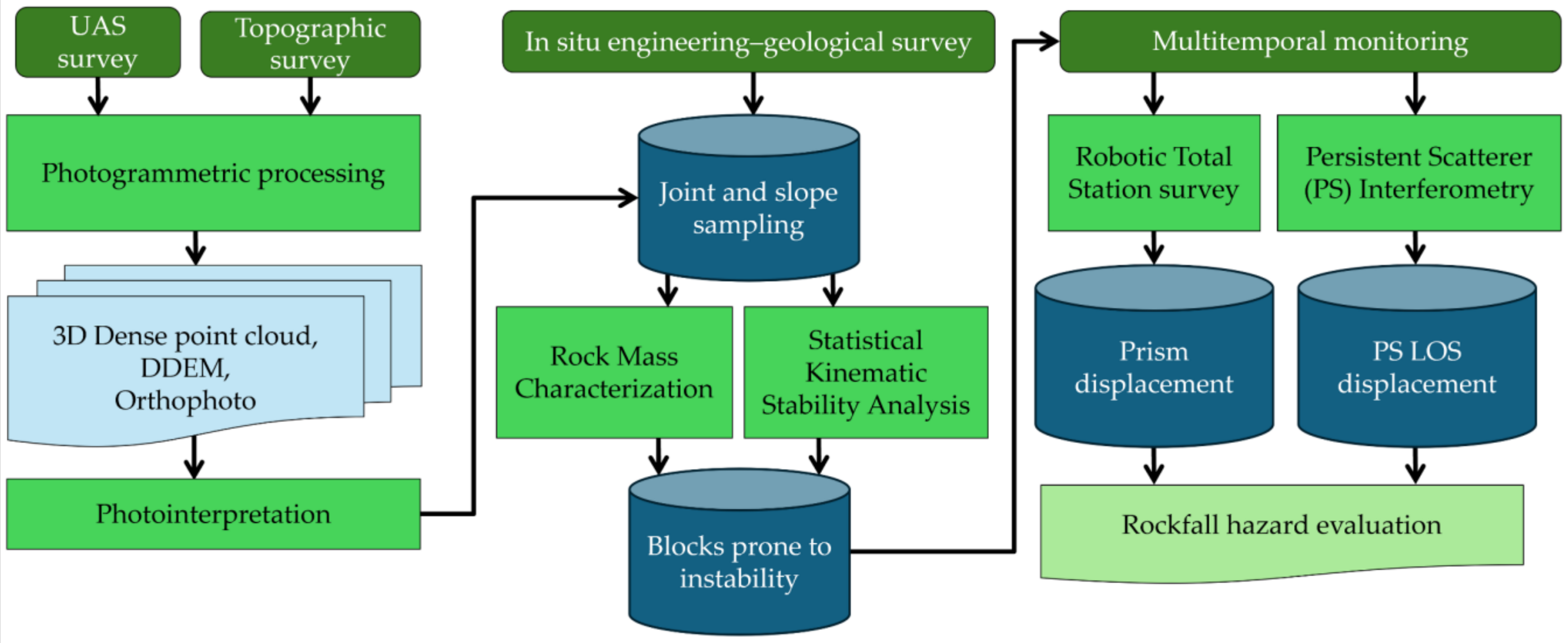
The comprehensive analysis of the present case study includes geological survey and multitemporal monitoring methods: the first was carried out by topographic, photogrammetric, and in situ engineering–geological surveys, slope geological photointerpretation, rock mass characterization, and statistical kinematic stability analysis (Section 3.1, Section 3.2, Secton 3.3 and Section 3.4). The multitemporal monitoring was performed through RTS surveys and PSI analysis (Section 3.5 and Section 3.6). Figure 2 shows the overall methodology flowchart.
The topographic and photogrammetric surveys aimed at creating a 3D model output that is useful not only for identifying elements prone to instability but also for characterizing the discontinuity systems for a wider area. These data, together with results from the engineering–geological surveys, were utilized to perform the subsequent slope kinematic stability analysis. Moreover, data from the geological surveys allowed us to define rock blocks, wall portions, and pinnacles prone to instability that were chosen for the installation of the monitoring prisms, as explained in Section 3.5. The multitemporal monitoring, which was carried out for a time span of 2 years, was conducted periodically in accordance with the Tuscany and Umbria Regional Directorate of the State Property Agency, which funded the research. The PSI analysis was performed to evaluate possible displacements at the top of the slopes in areas not visible from the RTS and, possibly, to validate some results facing along the rock walls.

3.1. Topographic Survey

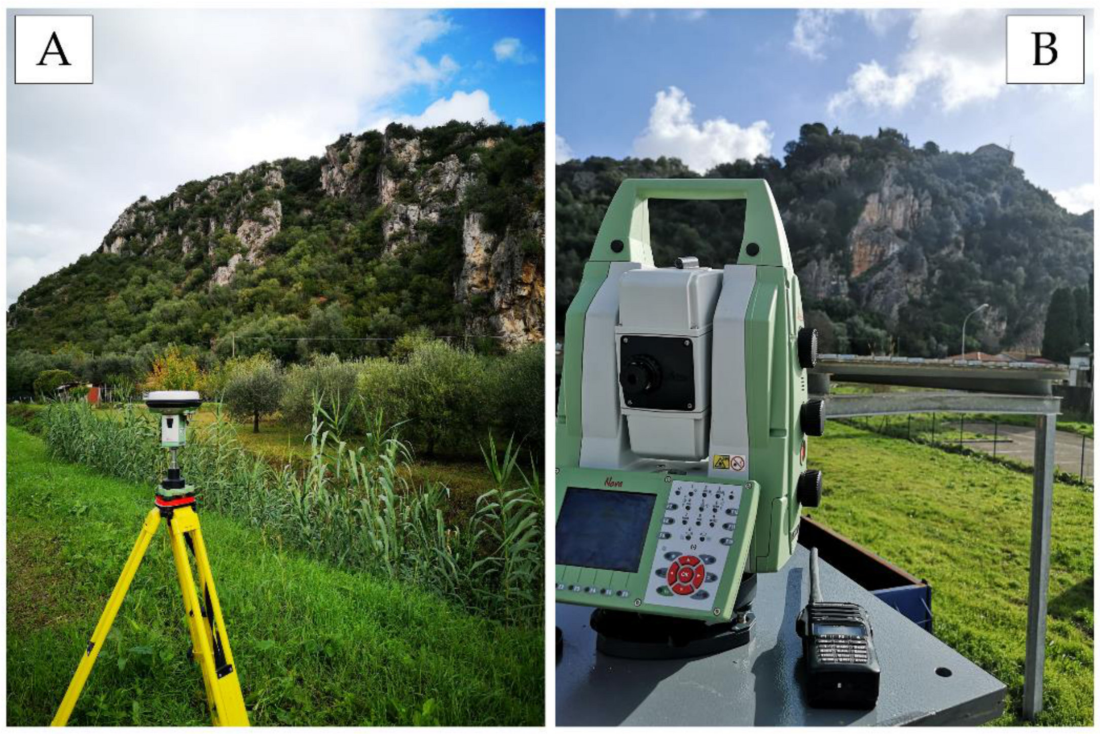
The topographic survey was carried out utilizing a LeicaTM Viva GS15 dual-frequency geodetic GNSS receiver and a LeicaTM Nova MS50 RTS (Figure 3). The latter has an angular accuracy of 1″ for both horizontal and vertical measurements and a 1 mm + 1.5 ppm (parts per million) accuracy for distance measurements.
The GNSS topographic survey was aimed at georeferencing artificial markers utilized for the exterior orientation of images acquired by the UAS photogrammetric survey. Real-Time Kinematic (RTK) positioning was adopted with a minimum acquisition time of 30 s per marker at 1 s of observation rate. The orthometric height of all the measured markers was later calculated by using ConverGo software (version 2.04) [56].
Moreover, to georeference the whole RTS monitoring system, the absolute coordinates of two temporary reference points were measured in areas proximal to the RTS base location. The GNSS absolute coordinates of these two temporary points were measured in static modality for a period of approximately 3 h. Then, they were processed using Leica Geosystems™ Infinity software (version 3.4.2) [57] and differential methods by combining simultaneous records from permanent GNSS stations of the Leica Geosystems™ SmartNet ItalPos national network. This procedure allowed sub-centimetric accuracy for the two GNSS temporary points, later utilized to shift and rotate the whole RTS survey and make it georeferenced. The georeferencing of the RTS survey was solely used for visualization purposes since the monitoring was conducted in a local coordinate system.
Prior to conducting the topographic survey, a careful inspection process was undertaken in accordance with the Tuscany and Umbria Regional Directorate of the State Property Agency to identify the optimal site for installing the RTS reference base. Therefore, a pivotal position was strategically chosen at the bottom of the rock slope in such a way as to have a clear view of the prisms to be installed on the slope without obstructions and obstacles along the line of sight (Figure 3B).

3.2. UAS Photogrammetric Survey

The aerophotogrammetric survey covered an area of about 18 ha, and it was conducted utilizing a DJITM Mavic 2 PRO equipped with a Hasselblad L1D-20C camera (1-inch sensor, 20-megapixel resolution, 10.26 mm lens).
The area was surveyed by 6 manual frontal flights due to the complex morphology and one nadiral flight in automatic mission using the UgCS software (version 4.18) for flight planning [58]. During these flights, a total of 426 high-spatial-resolution images (i.e., GSD—Ground Sampling Distance—of 2.8 cm) were acquired.
Images were externally oriented through the SfM—Structure from Motion—and MVS—Multi-View Stereo—techniques by using the Agisoft MetashapeTM software (version 2.0) [59]. The alignment was conducted utilizing 9 Ground Control Points (GCPs) and 4 Check Points (CPs) materialized by artificial markers. Among GCPs, 5 natural points were measured by the RTS on vertical rock walls.

3.3. Engineering–Geological Survey and Rock Mass Characterization

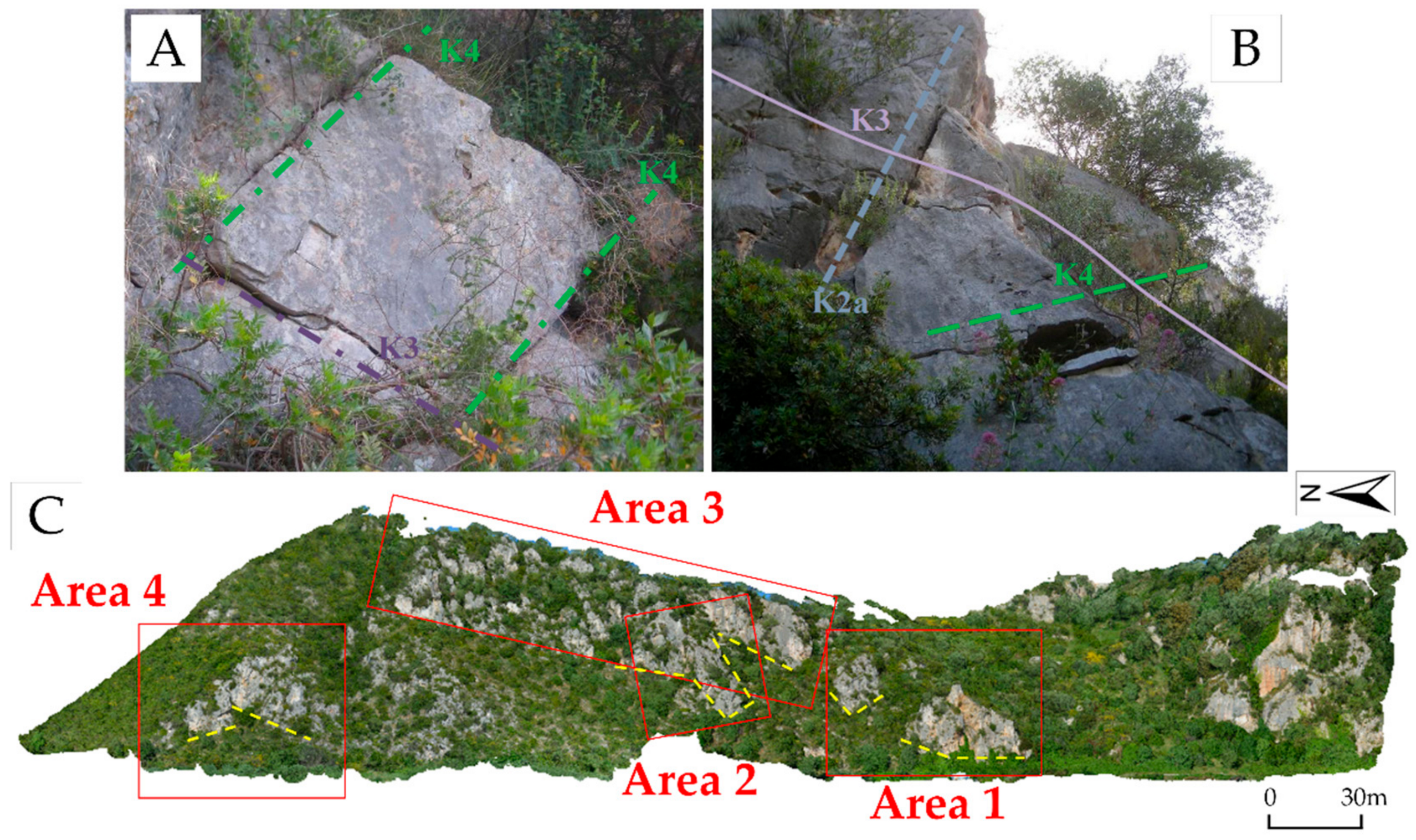
The in situ engineering–geological survey was carried out in safe and accessible areas along the rock walls (some examples are shown in Figure 4A,B). In addition to the traditional survey, further sampling of joints was carried out on the textured 3D point cloud by a tailored tool in CloudCompare software (version 2) [60]. Figure 4C shows the areas on the slope where this additional selection and measurement of joints was done.
The final dataset, available for rock mass classification and statistical kinematic stability analysis, is represented by a total of 237 joints.
The data collected from the in situ engineering–geological survey includes information such as discontinuity orientation, spacing, persistence, aperture, type and thickness of infilling, roughness and JRC—Joint Roughness Coefficient (derived from profilometer tests), weathering, humidity, and indirect uniaxial compressive strength (derived from the Schmidt hammer rebound tests).
The data were analyzed according to the Rock Mass Rating—RMR—method proposed by Bieniawski [61] and the Slope Mass Rating—SMR—method proposed by Romana [62]. These two methodologies consider the computation of a rating utilizing the data collected on the discontinuity systems; the resulting rating corresponds to a specific rock mass or slope mass quality range that also defines the possible necessity for supports or reinforcements. It was chosen to consider both methodologies to have a more complete characterization of the site, considering both the rock mass quality and the geometries influencing its stability. In fact, the SMR method, starting from the RMR basic value (RMRb), is designed for assessing rock slope stability, taking into account further parameters like the slope and joint attitudes and their relation. The slopes considered for the application of the SMR method were defined by analyzing the 3D point cloud obtained by the aerophotogrammetric survey.

3.4. Statistical Kinematic Stability Analysis

The kinematic stability analysis delves into the geometric relationships and potential failure of individual rock blocks or masses within a slope. This type of analysis is crucial in geotechnical engineering when evaluating the stability of natural and engineered slopes. The blocks are defined by discontinuities or planes of weakness, which could be joints, faults, bedding planes, or other geological features.
The methodology allows for the identification of potential failure mechanisms by assessing the kinematics of blocks. The method considers possible failure surfaces along which sliding or rotation may occur. By examining the geometry of these surfaces, potential failure modes and the conditions under which slope instability might occur can be predicted.
The analysis was carried out by utilizing the stereonet visualization proposed by Markland [63] and revised by Hoek and Bray [64]. The kinematic mechanisms that can be highlighted by this method are planar sliding, wedge sliding, and toppling (direct, oblique, and flexural). The failure possibility is not only related to joint systems and slope interaction but also to exceeding the rock mass friction angle (φ) value.
For the present case study, the data collected by the engineering–geological in situ survey, together with those from the photointerpretation of images acquired by the UAS, were utilized to identify and characterize joints to be used for the stability analysis performed using RocscienceTM Dips software (version 8.022) [65].

3.5. Multitemporal Monitoring through RTS

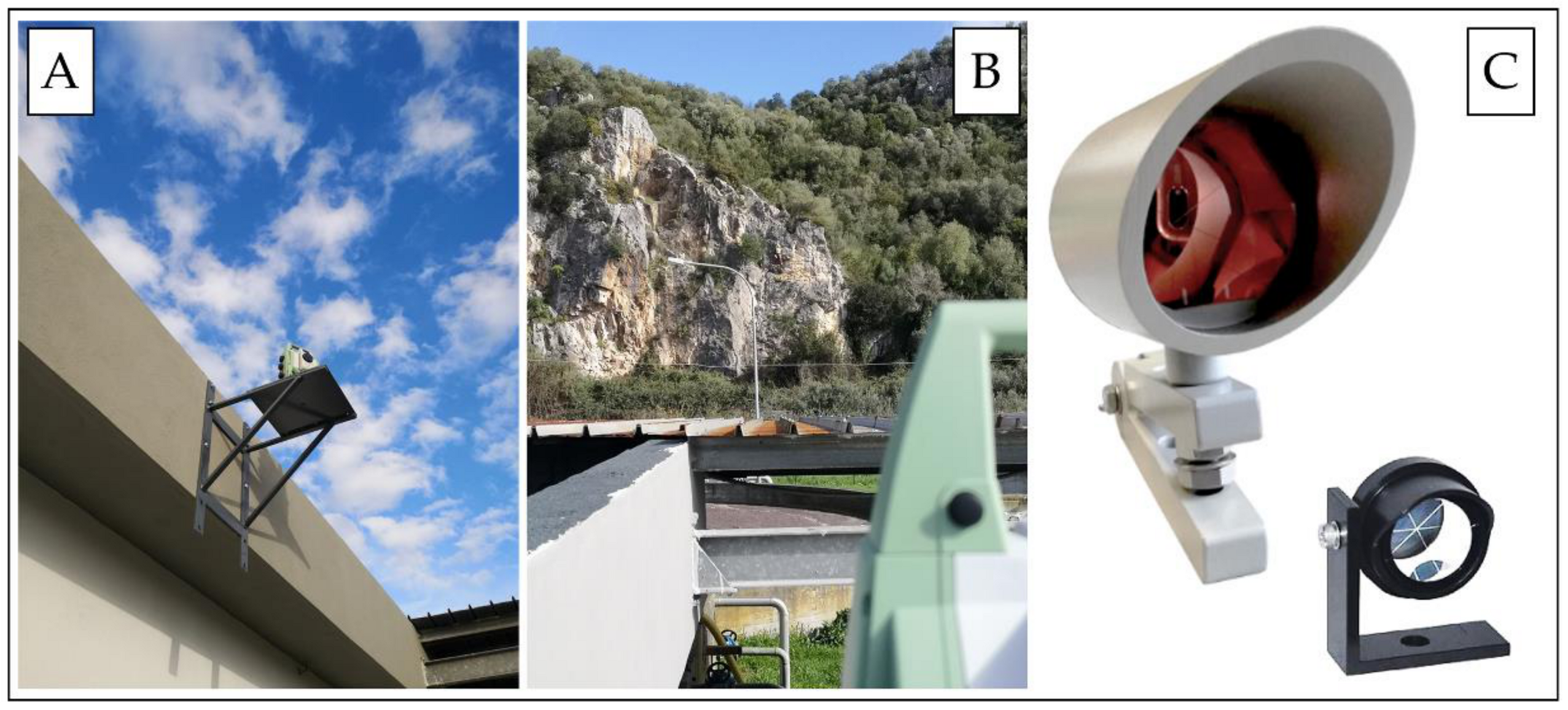
The multitemporal monitoring was carried out through eight RTS surveys plus the initial one, which was named “Survey n.0”, covering a time span of about 2 years. The RTS monitoring surveys started in February 2020 before the pandemic, and the following activities were planned in accordance with the health guidelines. The point of origin for the monitoring system was set up on an iron plate designed to support the weight of the RTS and anchored to a reinforced concrete curb of a masonry building present in the area (Figure 5A). To monitor blocks or rocky wall portions considered prone to instabilities, rounded optical prisms were installed on rocky walls and on buildings. The choice of prism size was related to the distance from the “base”: microprisms were utilized for distances below 200 m, while macroprisms were selected when the distance exceeded 200 m (Figure 5C). The difference between the two prisms is related to their reflecting crystal diameter (25.4 mm and 63 mm for microprisms and macroprisms, respectively) and precision (lower than 3″ and 5″ for microprisms and macroprisms, respectively).
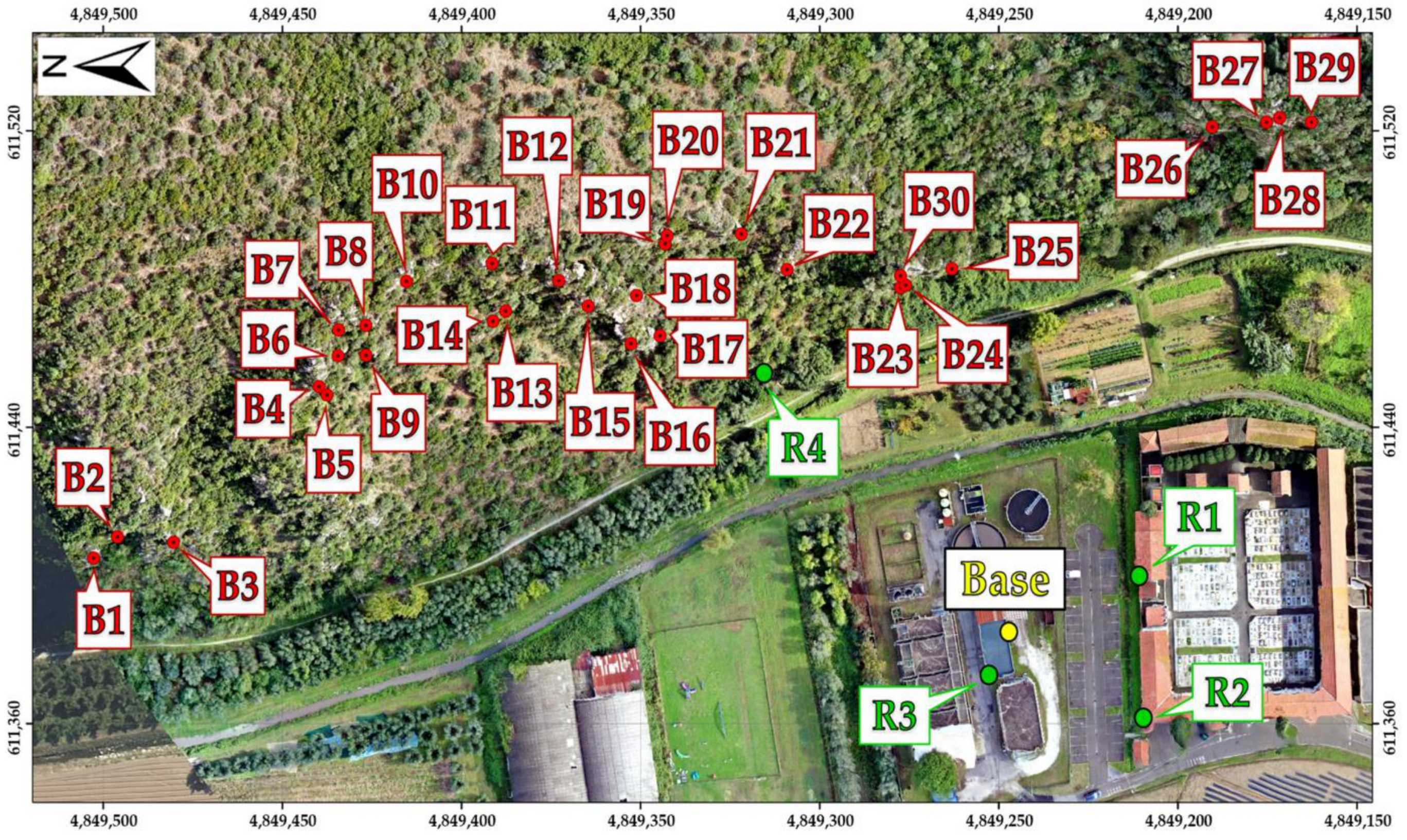
Based on results from the engineering–geological survey and kinematic stability analysis, 34 prisms were placed (Figure 6). Among them, 30 were considered monitoring prisms (B1, B2, …, B30) and installed on the rock walls by specialized climbers. The remaining ones were considered as reference prisms and installed on buildings nearby the “base” origin of the survey (R1, R2, and R3) and on a rock outcrop at the base of the slope to be monitored (R4), far and hardly accessible to hikers or climbers. The reference prisms were set up in such a way as to have the same RTS orientation for each individual survey and to know the errors connected to every positioning phase.
During every single survey, the RTS was set to collect 10 measurements in a double-sided configuration for each prism and to average them. The double-sided measurement, also known as “two-faces” measurement, allows for measuring a prism the first time with the normal face of the RTS and the second time with the back face. In this way, some of the instrumental errors are eliminated by averaging the angles from both faces. This technique was employed to enhance the accuracy and reliability of results by reducing the noise and interference, adjusting the systematic error, detecting errors caused by temporary obstruction, and improving the statistical confidence.
The precision of the executed measurements was assessed after every single survey, and the obtained results are shown in Section 4.5.
Before processing the monitoring data, it was necessary to analyze the instrumental initial uncertainties related to the used RTS and prisms, as well as other possible sources of error. This study included the definition of uncertainty thresholds below which certain conclusions cannot be drawn.
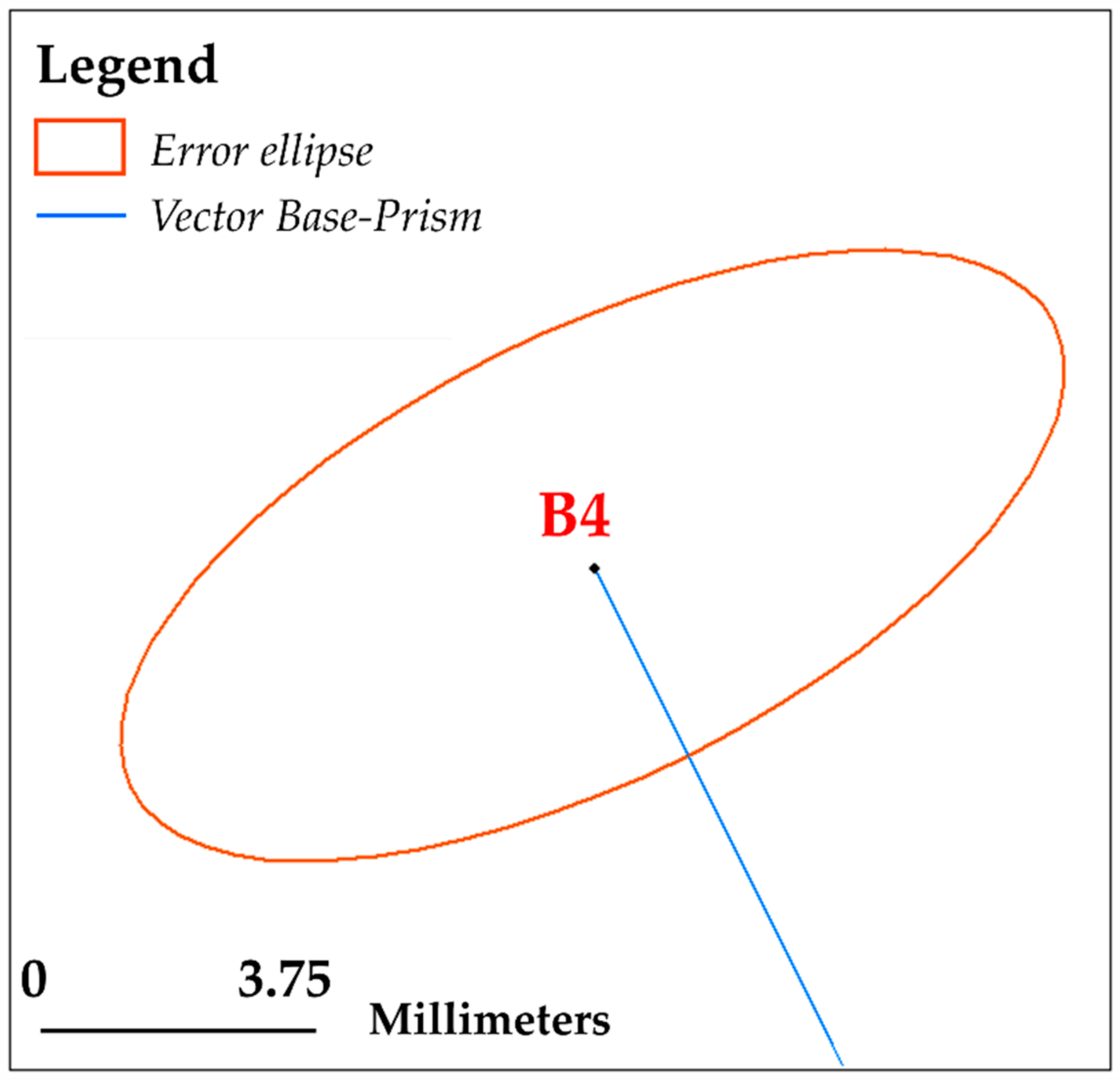
The first aspect that was considered is the RTS instrumental accuracy, as mentioned in Section 3.1. Since the instrumental precision is 1” for angular measurements and ±1 mm (+1.5 ppm) for distance measurements, the theoretical instrumental uncertainty varies from point to point and differs for angular and distance measurements. This requires the definition of an error ellipse centered on every single point to be monitored. Considering the distance from each prism to the RTS, as reported in Table 1, the major axis of the error ellipse is orthogonal to the vector connecting the monitoring prism to the base, while the minor axis is parallel to the latter.
The angular uncertainty calculation was performed by applying the following formula:
A n g u l a r   U n c e r t a i n t y ± m m = t a n 1 3600 p r i s m   d i s t a n c e
Conversely, to compute the uncertainty in distance for each prism, the following formula was utilized:
D i s t a n c e   U n c e r t a i n t y ± m m = 1 + 1.5 p r i s m   d i s t a n c e 1000,000
Additionally, it was necessary to consider the contribution of the monitoring prisms, which introduces further uncertainty. Since the error contribution of individual prisms is complex, and the use of algebraic methods for rigorous analysis can result in challenges due to atmospheric conditions that could affect the modulated near-infrared RTS signal delays, a precautionary estimate was performed. It was decided to assess the contribution of the prisms with an additional ±1.5 mm, both for angular and distance uncertainty. Still evaluating further sources for uncertainty, it was decided to consider variable atmospheric conditions, such as humidity, pressure, and temperature; the thermal expansion of materials during specific periods of the year; lighting conditions; and other types of accidental errors of various natures. Some of these errors can be mitigated through multiple averaged measurements, but others are not easily estimable and are challenging to eliminate.
In each single survey, the prisms were measured in 10 distinct and consecutive cycles in a double-sided configuration, and the obtained results were averaged. Assuming that no movements were recorded in the period between the first and last measurement of a single session (the entire procedure lasts a maximum of 60 min), it was possible to directly assess the standard deviation of measurements. The in-depth analysis of the 10 measurement cycles allowed us to obtain realistic uncertainty values on the single survey, separately for each prism. These uncertainty values (then rounded up since sub-millimetric values have no topographical significance) include both instrumental and environmental uncertainties due to the peculiarities of the site where the base of the monitoring system is installed (alluvial plain of the Serchio River) and the adopted measuring method (i.e., multitemporal survey instead of continuous monitoring). When the standard deviation of measurements was found to be lower than the instrumental one, the latter was precautionarily taken as a reference.
Table 1 presents the final uncertainty values as obtained considering RTS and prism theoretical instrumental errors plus the environmental contribution.
Figure 7 shows, as an example, the graphical representation created in the GIS environment of the planimetric error ellipse for the B4 monitoring prism.
According to this approach, planimetric and elevation contributions were analyzed separately. The adopted method allows us to evaluate the presence of possible displacement trends of prisms, even if they are contained within the error ellipse of uncertainty, and, eventually, to adopt any precautionary measures aimed at counteracting rock collapses. On the contrary, in the case of a stationary prism, apparent positive and negative displacements result in a random distribution around the Survey n.0 value, and no further interventions are needed.

3.6. Persistent Scatterer Interferometry

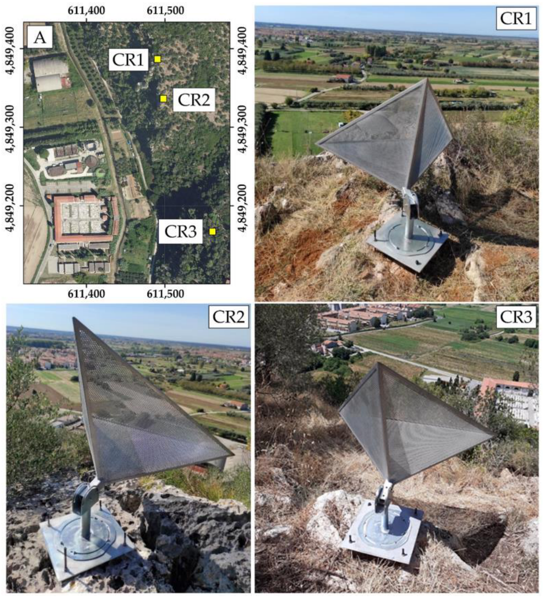
The interferometric analysis was carried out with the aim of assessing the stability at the top of the slopes in areas not visible from the RTS. Traditional DInSAR—Differential Interferometric Synthetic Aperture Radar—techniques compare radar images from different times to detect millimeter-scale changes by analyzing the phase differences in radar signals. DInSAR has limitations in the case of non-linear strain rates and high time interval observations that cause the decorrelation of phase information [66]. Therefore, to characterize non-linear strain rates over long time intervals, particular interferometric techniques have been developed over the last few years; such techniques use a huge dataset of radar images and their relative phase differences. Among these techniques, PSI—Persistent Scatterer Interferometry—analyzes the amplitude and phase information of isolated pixels, defined as Persistent Scatterers (PSs), which are characterized by high values of the temporal stability of the back-scattered signal [66]. Either anthropic features (e.g., buildings and metal structures) or natural elements with high signal coherence (e.g., rocky outcrops, bare land) can play the role of PSs. In this work, three artificial targets (i.e., corner reflectors) were properly built and installed to be used, hopefully, as PSs (Figure 8) according to guidelines reported in [67]. The reason behind their installation is the possibility of verifying displacements at the rocky wall’s top edge, and their location was strategically chosen in non-vegetated areas, while their orientation follows the look direction of the satellite that was used.
Many algorithms were developed over time for the PSI technique. In the present case study, the algorithm developed by Hooper et al. [68] was used. The algorithm allows us to create interferograms through the combination of a single reference image and several secondary scenes, considering the phase difference over a certain time span. Compared to other methodologies, the utilized algorithm allows us to consider low-amplitude natural targets on the ground without requiring a deformation model. To elaborate a great amount of data, Foumelis et al. [69] proposed a particular integrated processing workflow that is named SNAP—StaMPS (SeNtinel Application Platform—Stanford Method for Persistent Scatterers). The workflow is based on the SNAP software (version 7.00) developed by ESA [70] and the StaMPS algorithm of Hooper et al. [71]. By this technique, a PS candidate for the evaluation of ground deformation is initially identified by calculating the ADI—Amplitude Dispersion Index—for each pixel. Subsequently, by analyzing the phase stability over time, the method establishes whether a pixel can be a scatterer candidate. The PS density varies depending on the land use and morphology. In general, for SAR images, the highest densities are reached in urban or anthropized areas with artificial elements, while they are almost completely absent in vegetated and agricultural lands [72,73,74].
In the present case study, Sentinel-1A and -1B radar images were downloaded from the ASF Alaska Data Search platform [75]. The chosen scenes have the following characteristics: ascending acquisition orbit, Single Look Complex (SLC) format, Interferometric Width (IW) swath acquisition mode, and dual polarization (VV+VH).
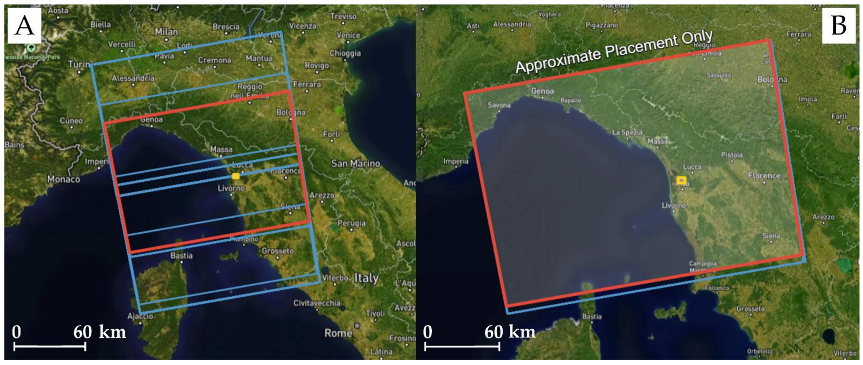
Figure 9A shows the images covering the area of interest, while Figure 9B indicates, as an example, two scenes chosen for their spatial correspondence; if one or more images exceed a certain spatial offset, as in Figure 9A, the analysis stops during the processing. On the contrary, high spatial and temporal coherence among scenes belonging to the same path and frame number guarantees a successful analysis. For this reason, the dataset of Sentinel images in descending orbit acquisition was not used since their spatial correspondence was not satisfactory for PSI analysis.
Table 2 summarizes the information for the dataset utilized during the interferometric analysis comprising the satellite, the considered time span (first and last scene date), the acquisition orbit, the path and frame number, and the number of utilized images.

4. Results

4.1. UAS Photogrammetry

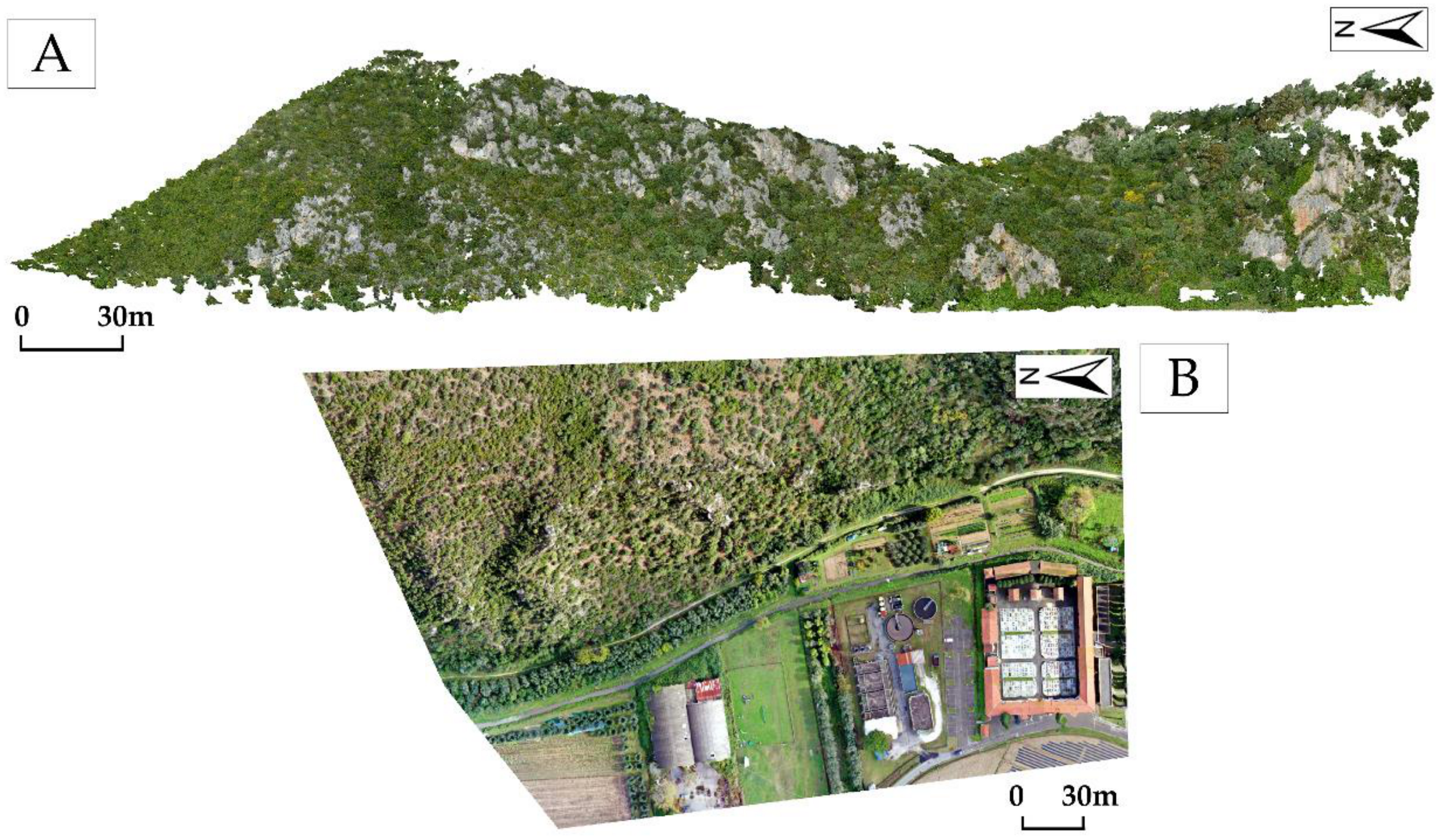
The images acquired during the UAS aerophotogrammetric surveys were aligned utilizing 3.4 million recognizable tie points, GCPs, and CPs that were processed within the Agisoft MetashapeTM software (version 2.0) [59]. The Root Mean Square Error (RMSE) resulting from the processing is 9.84 cm for GCPs and 8.50 cm for CPs, respectively. Subsequently, a global 3D point cloud of about 114 million points was created; it was downsampled to 80 million, focusing only on the morphologies of the areas of interest (Figure 10A). From the DDEM, created from the 3D point cloud interpolation, the nadiral orthophotomosaic of the study area was produced at a GSD of 5 cm/pixel (Figure 10B). All the output refers to the ETRF2000/UTM32N geodetic system. This process is particularly important since the availability of georeferenced products can allow future surveys and analysis. Moreover, the DDEM and the orthophotomosaic aided in mapping rocky blocks and discontinuities and in planning the installation of monitoring prisms.

4.2. Engineering–Geological Survey

The data collected during the in situ engineering–geological survey and photointerpreted on the global 3D point cloud, DDEM, and orthophotomosaic were merged to create a database of joints comprising 237 orientation measurements.
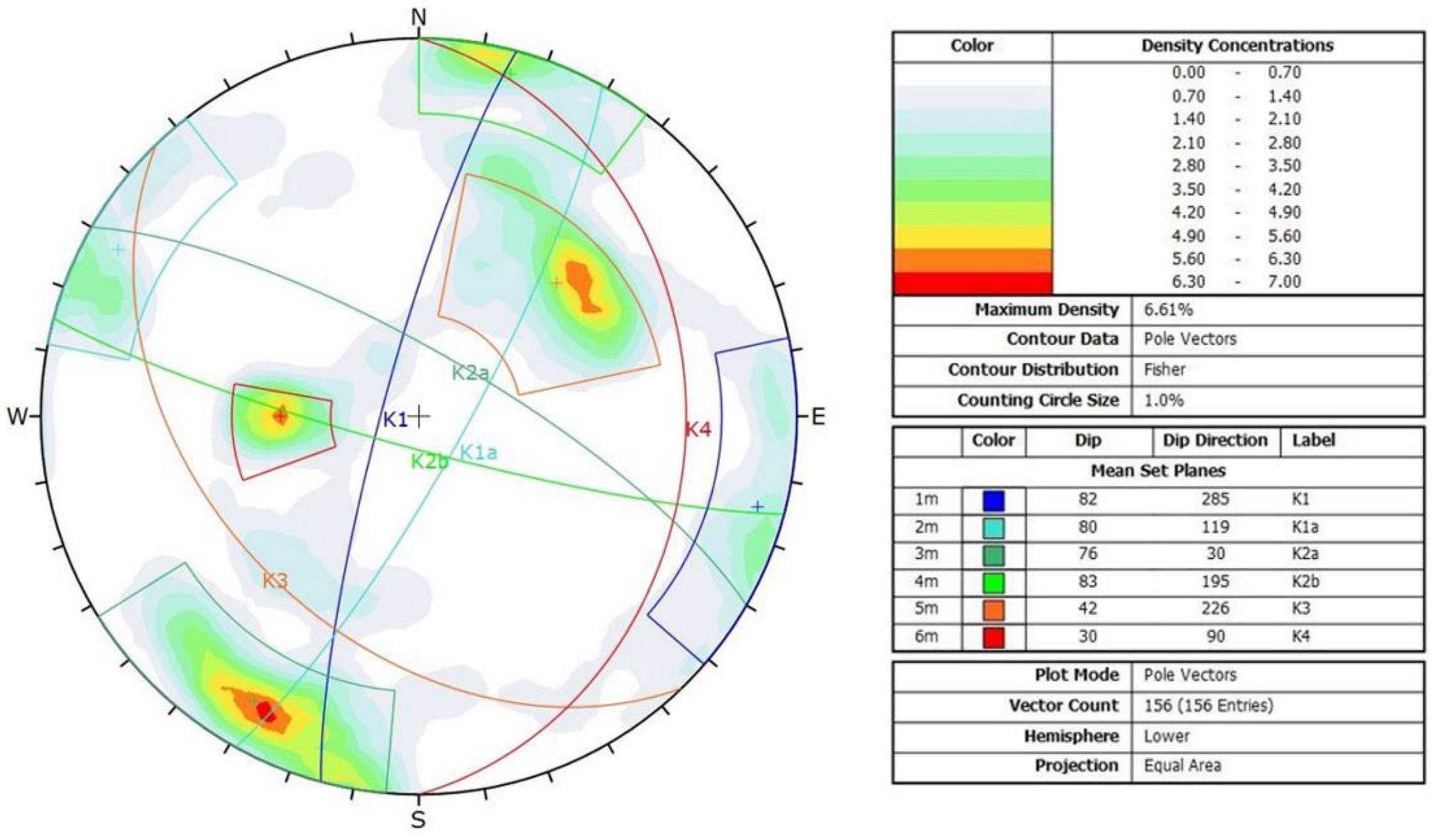
To verify the actual correspondence between the accuracy and reliability of these two survey methodologies, results were first plotted on stereonet graphics. Figure 11 shows the analysis of the 81 measurements conducted through the in situ survey on safe and accessible outcrops at the base of the rocky walls (Figure 4); Figure 12 shows the analysis of the 156 joints interpreted on the 3D point cloud.
Figure 11 and Figure 12 demonstrate the coherence of results from the in situ data collection and the 3D point cloud photointerpretation with mean difference values of dip and dip direction of 3° and 14°, respectively. The latter is highly influenced by the maximum observed difference, which is related to the low dip direction value of the K4 joint set (i.e., 42°) measured in different locations; the in situ collection was conducted at the bottom of safe rocky walls, and meanwhile, the 3D point cloud sampling was performed in areas not accessible by personnel (i.e., rocky wall edges and higher vertical surfaces).
The data from the two surveys were merged and utilized to fully characterize the discontinuity systems affecting the whole rock mass. Table 3 summarizes the characteristics of discontinuities as collected through the in situ engineering–geological surveys with attitudes averaged with those from the 3D point cloud photointerpretation.
The collected data, which were considered satisfactory both in quantitative and qualitative terms, were subsequently utilized to characterize the rock mass and to evaluate the kinematic stability phenomena that could affect the rock walls.

4.3. Rock Mass Classification

4.3.1. RMR Method

The RMRb value obtained for the whole rock mass is equal to 72, meaning that it can be considered of “good” quality. In addition, in Bieniawski [61], some empirical formulas are proposed to indicatively estimate the rock mass friction angle (φ), cohesion (c), and deformation modulus (E). The values obtained for this case study are the following: friction angle (φ—degrees) equal to 41, cohesion (c—MPa) equal to 0.36, and deformation modulus (E—Gpa) equal to 44. The rock mass friction angle was utilized for statistical kinematic stability analysis, as later described in Section 4.4.

4.3.2. Romana Method

The application of the Romana method [62] allowed us to further characterize the rock mass considering the RMRb obtained value plus the interaction between discontinuities and slopes identified as fundamental for the stability analysis. The common mechanisms of planar, toppling, and wedge failure were considered. The SMR method was applied to six representative slopes, for which dip directions and dips were sampled utilizing the 3D point cloud. In order to consider the natural variations of dip angles, slopes V5 and V6 were included in the analysis with a decreased value (i.e., 65°) with respect to V1 and V2. Figure 13 shows the location of the most representative slopes encountered in the study area.
Based on the discontinuity systems summarized in Table 3 and the six representative slopes of Figure 13, the SMR values were computed, and their results are shown in Table 4.
The obtained results show SMR values indicating a rock mass of “good” (Class II) or “very good” (Class I) quality. Block failures are unexpected, and occasional supporting methodologies (e.g., scaling) can rarely be considered. The minimum values, equal to 45 (Class III—normal quality) and 36 (Class IV—bad quality), refer only to planar sliding and correspond to the interactions of the K1 (288/82) discontinuity system with slope V1 (280/88) and K3 (227/40) with slope V6 (280/65), respectively. In these cases, the rock mass quality is comprised within the classes “normal” and “bad”, indicating partially unstable or unstable slopes with the need to provide supports and reinforcements.

4.4. Statistical Kinematic Stability Analysis

The kinematic stability analysis was performed considering the six representative slopes using the rock mass friction angle (φ) equal to 41°. Table 5 summarizes the obtained results.

4.5. Multitemporal Monitoring through RTS

Before showing the results obtained by multitemporal monitoring, and in order to demonstrate the reliability of measurements, Table 6 shows the average precision value estimated for each RTS monitoring survey. The slope distance precision is expressed in mm, and it varies from 0.1 to 0.2 mm. The angle precision is expressed in seconds (”), and it ranges from 1.1 to 4.2 for the azimuthal angle and from 0.9 to 1.5 for the zenithal angle.
These values are largely consistent with the final uncertainty threshold values for each monitoring prism, as reported in Table 1.
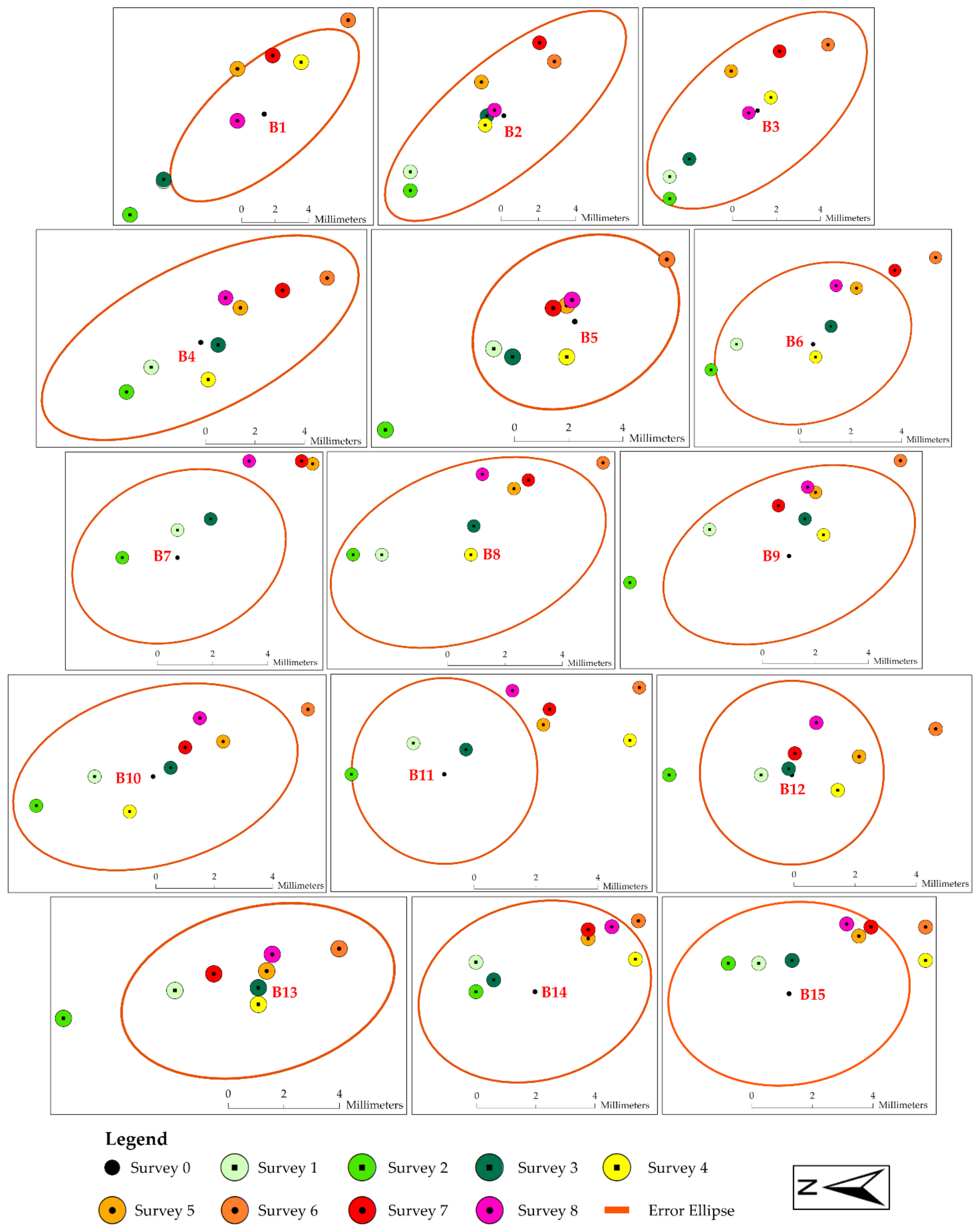
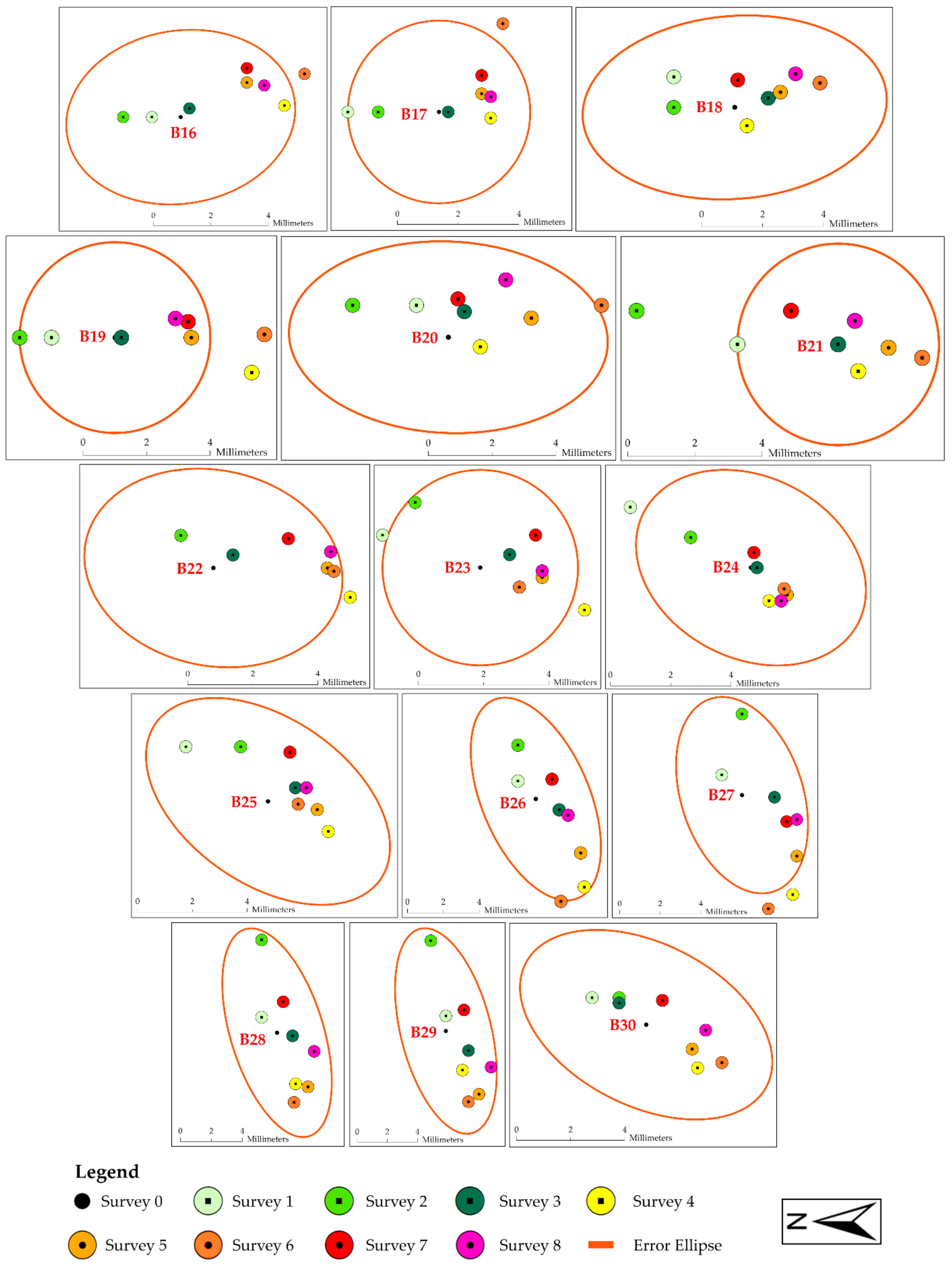
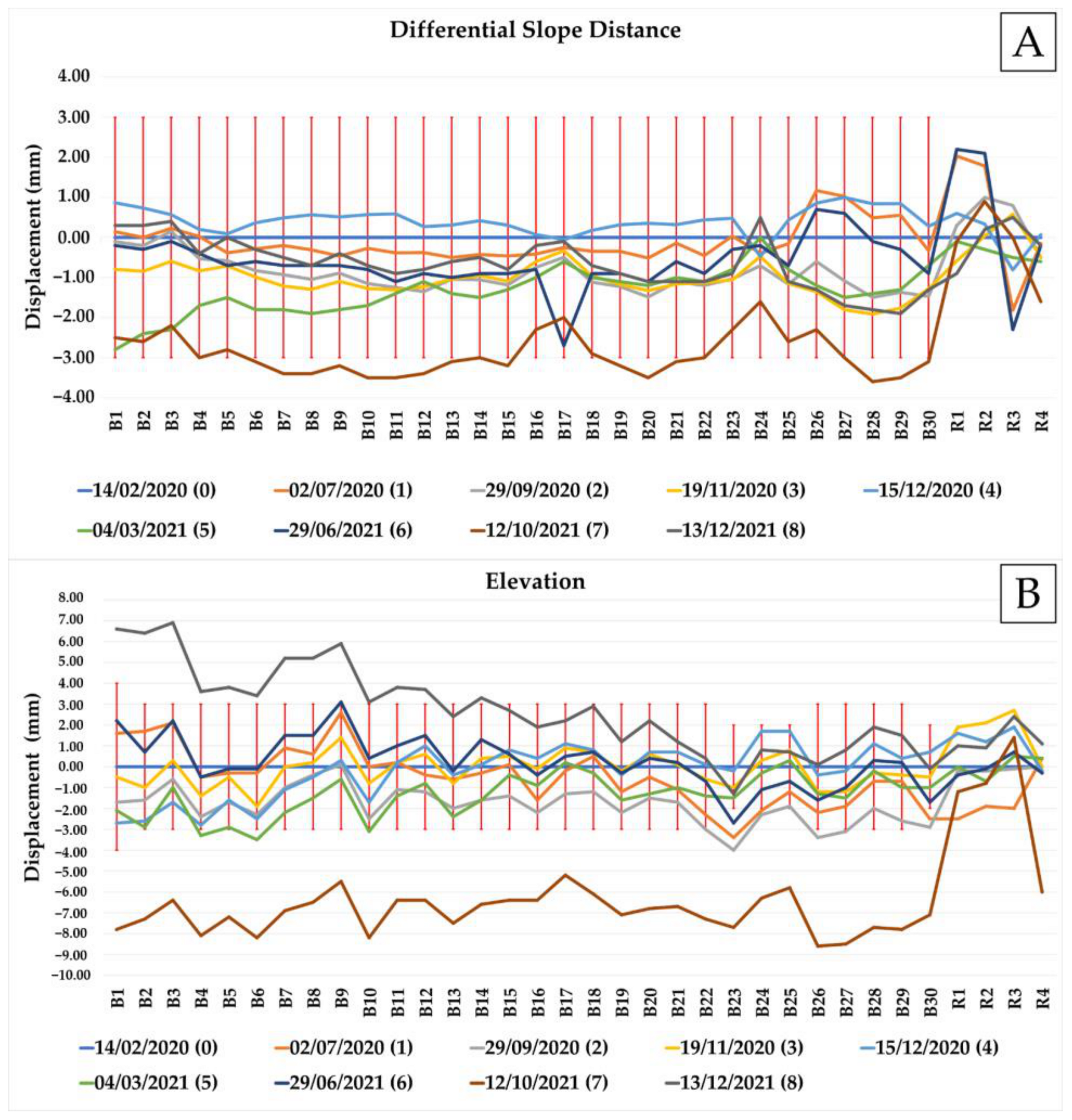
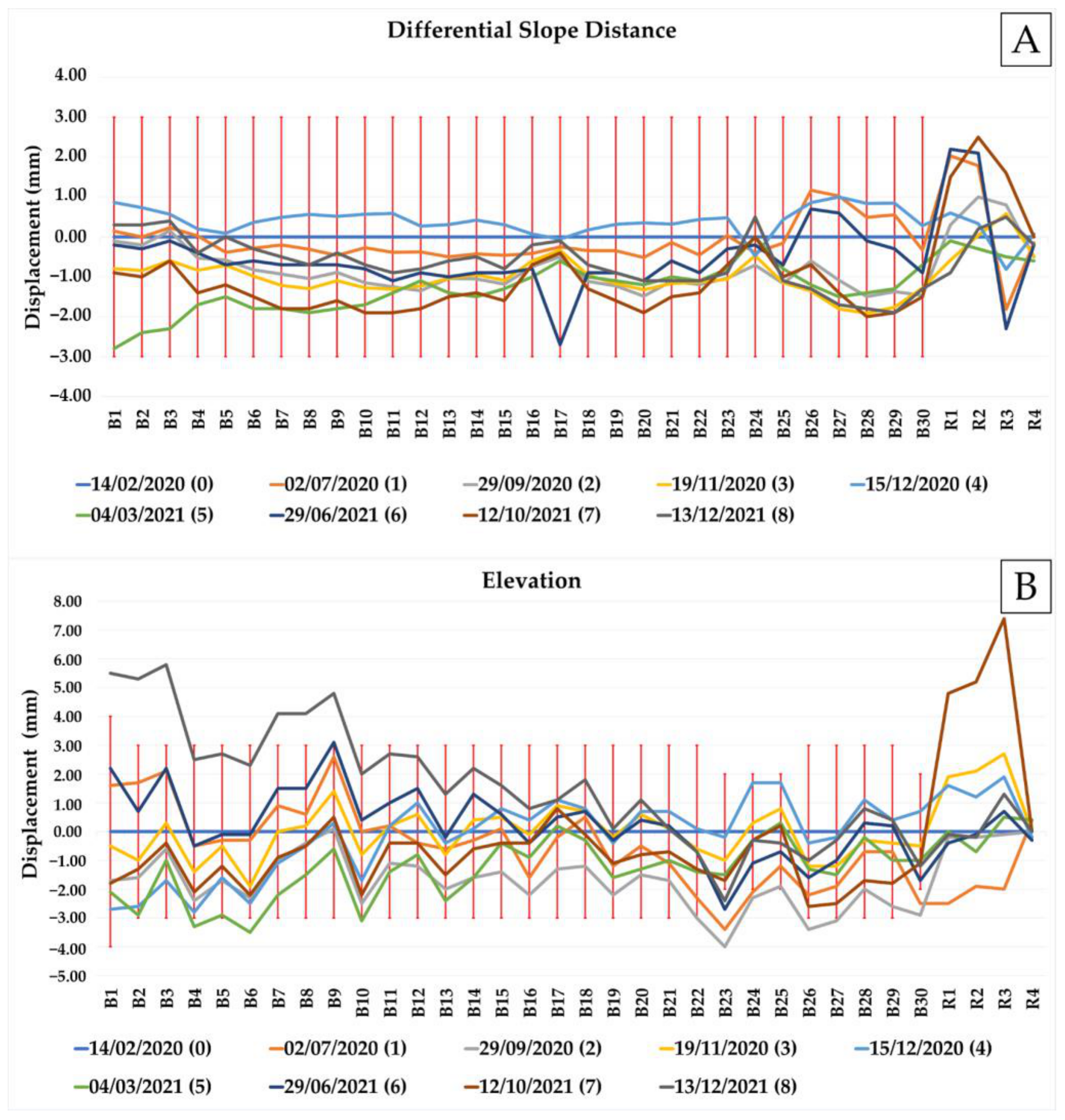
The results obtained by the multitemporal monitoring, comprising also the initial survey (i.e., Survey n.0) that was considered as reference, are shown in two steps: firstly, results are shown through the planimetric error ellipses (Figure 14 and Figure 15), and then, their trends are shown through diagrams (prism ID versus displacements) in terms of differential slope distance (i.e., distance between the base and each prism; Figure 16A) and elevation (Figure 16B). The red vertical bars in both the diagrams of Figure 16 represent the slope distance and elevation uncertainty thresholds, respectively, for which the calculation is explained in Section 3.5.
The results of Figure 14 and Figure 15 allow us to exclude the presence of any trend regarding instability and show a random distribution. In particular, the monitoring prisms B2, B3, B4, B18, B25, B28, B29, and B30 show values always within the ellipse area (8 out of 30). All the other prisms, even if during the time span they are sometimes out of the planimetric error ellipses, are always still recognizable by the RTS at the end of the survey (i.e., December 2021), indicating general stability of the rock walls.
In the diagrams of Figure 16, no evident trends might be highlighted except for the last two surveys, namely, the seventh and eighth RTS monitoring surveys (respectively, in brown, dated 12 October 2021, and dark grey, dated 13 December 2021). The differential slope distance of monitoring prisms in Figure 16A shows values at the limit of the uncertainty thresholds only for the seventh monitoring survey; meanwhile, the values for the eighth are fully within the thresholds. The elevation displacements (Figure 16B), instead, are far beyond the thresholds for both monitoring surveys.
In particular, the anomaly of the seventh monitoring survey led to the need for additional analysis to assess the reason behind it. Then, it was decided to proceed in two ways: (i) deepen the study on the reference prisms and the RTS position and (ii) analyze the results of the PSI analysis to verify possible additional land displacements through the methods described in Section 3.6.
During the seventh RTS survey, measurements of the monitoring prisms show coherent shifts between them, suggesting that critical issues can be attributable to vertical displacements of the base and the multitemporal nature and type of the survey. To assess this hypothesis, the differential slope distances and vertical displacements of Figure 16 were newly computed only with respect to the R4 reference prism, which is installed on a stable rock outcrop (Figure 17). This choice was related to the fact that R1, R2, and R3 are installed on buildings located in the alluvial plain, which could potentially be affected by natural vertical displacements. Moreover, some monitoring prisms, among the farthest from the total station, exhibited vertical displacements out of the instrumental tolerances or close to them during the eighth RTS survey (e.g., B1–B12 and B14 in Figure 16B). In particular, these results imply that these monitoring prisms moved up along the vertical direction. Similarly to what was applied to the seventh survey, values of the eighth survey were computed considering R4 as stable in terms of vertical displacements. Results of Figure 17 indicate that differential slope distances and vertical displacements are always within the uncertainty thresholds for all the measurement prisms. Only the reference prisms R1, R2, and R3 fell out of the elevation uncertainty limits during the seventh RTS survey. Instead, the eighth survey results show how only the farthest prisms are still beyond the thresholds (i.e., B1–B3, B7–B9) or right at the limit (i.e., B4–B6).
To explain the behaviors of these reference and monitoring prisms that exceeded the tolerance values, we resorted to the PSI analysis, for which the results are presented in the following Section 4.6.

4.6. Persistent Scatterer Interferometry

The area under study is quite complex to be studied by satellite PSI analysis for the presence of mixed vegetation (i.e., trees and bushes) at the top and the bottom of slopes, vertical rocky walls, and agricultural lands in the area where the RTS is installed. As mentioned in Section 3.6, vegetation and agricultural fields have a strong influence on the PSs’ visibility over time, and due to their high seasonal variability, it is common to have few or no scatterers in these zones. For this reason, to overcome these criticalities, the artificial corner reflectors shown in Figure 8 were installed at the top of the rocky slopes.
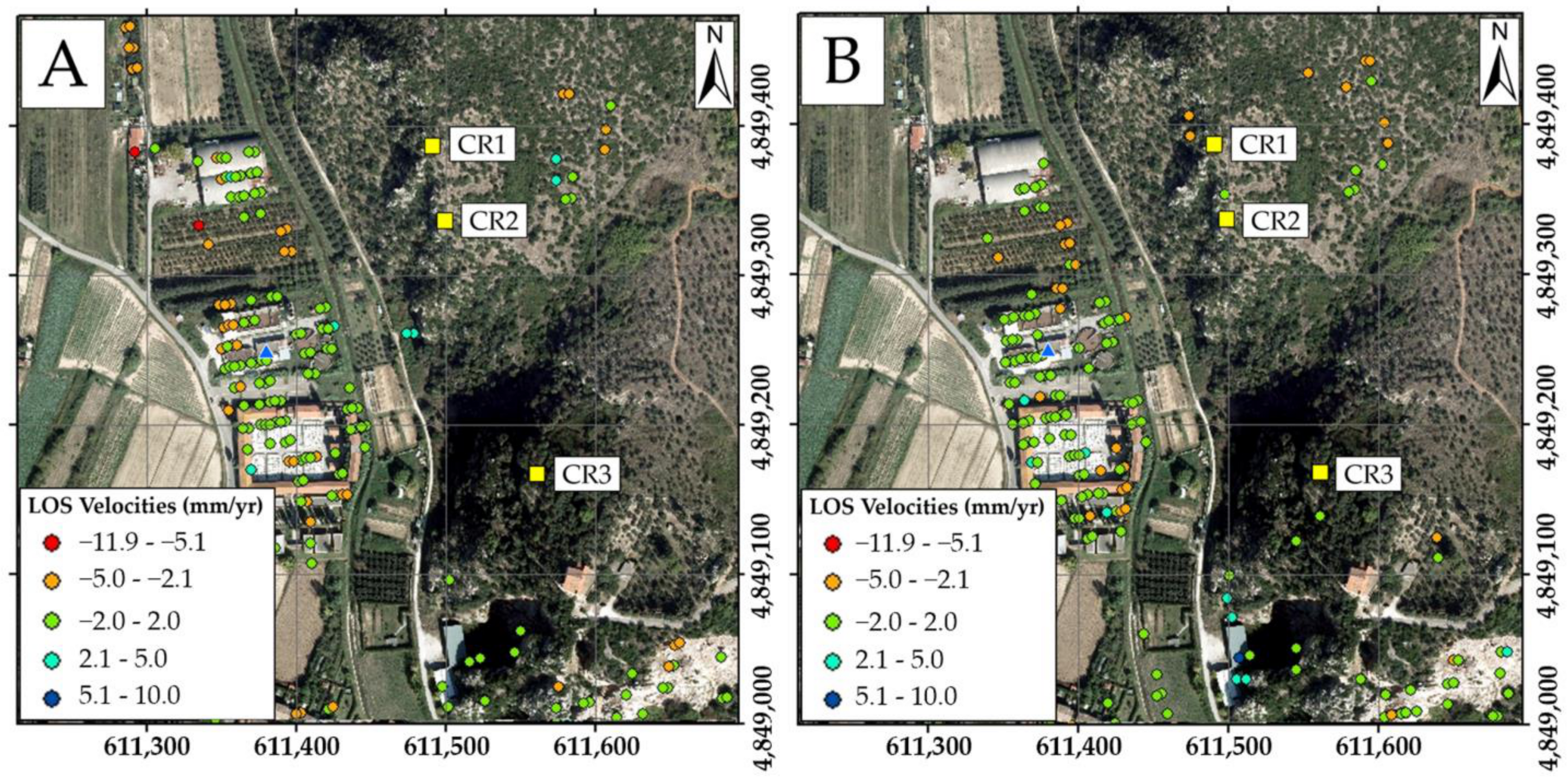
Figure 18A shows the results obtained by processing the satellite imagery related to the Sentinel-1A data; meanwhile, Figure 18B shows the results related to Sentinel-1B. The PSs are differentiated by color in relation to their velocity (mm/year) along the Line of Sight (LOS) from the satellite to the ground. These intervals are based on the common ranges utilized by PSI analysis and also proposed by the regional LaMMa (Laboratorio di Monitoraggio e Modellistica ambientale) interferometric service [76]. In this way, it is also possible to compare the results obtained by the present research with the ones published by the LaMMa service for the same study area.
In both figures, the alluvial plain area where the RTS is installed is characterized by LOS velocities indicating stability (i.e., −2.0–2.0 mm/yr., green dots) or light subsidence (i.e., −5.0–−2.1 mm/yr, orange dots). It must be remembered that the velocities represent the average values calculated for the whole considered time (i.e., first scene to last scene), and they are referred to as displacements along the LOS. A separation of vertical and planimetric components of the LOS was not possible in this work because of the lack of suitable Sentinel-1 descending orbit data in the same time span.
Thus, the analyzed trend can be interpreted as a tendency to subsidence rather than uplifting because the negative vertical component tends to be more significative. The subsidence could be related to the presence of (i) great seasonal fluctuations of the aquifer in an area characterized by alluvial and detrital material and/or (ii) several public and private pumping water wells.
As a support, our results were then compared with those published by the regional LaMMa interferometric service [76] for the same time span and satellite imagery dataset. The data shown in Figure 19 refer to the PSs identified by the LaMMa service; the point identified by ID “FV6XKKY” is near the RTS. The diagram below the map in Figure 19 shows the trend of this PS LOS velocity considering the interval of the RTS monitoring time span (i.e., from Survey n.0, dated 14 February 2020, to Survey n.8, dated 13 December 2021).
In correspondence with the seventh RTS survey, October 2021, the LOS velocities of Figure 19 show a negative trend, meaning that the PS has increased its distance and, therefore, has moderately subsided. Conversely, when observing the trend during the eighth RTS survey, December 2021, the LOS velocity changes towards positive values, indicating moderate uplifting.
These observations suggest possible seasonal vertical fluctuations of the alluvial plain of both natural and anthropic origin related to pumping well activity. This behavior is confirmed by the charts in Figure 17, where we tested the elimination of the subsidence by referring the RTS data processing only to the R4 reference prism, which is installed on a stable rock outcrop. It must be noted how the displacements of prisms B1 to B30 in Figure 17A remain within the uncertainty thresholds, while the other reference prisms (i.e., R1–R3), also located in the alluvial plain like the RTS, highlight positive anomalies, particularly in terms of elevation but also as differential slope distance, confirming their tendency to subside.
The uncertainty about the vertical stability of the area where the RTS is installed, as demonstrated by PSI, also justifies the behavior of some prisms in the eighth RTS survey, which exceed the tolerance values in elevation, especially at the highest distances from the “base”.
Last but not least, the obtained results allow us to exclude falls of rocky blocks during the investigated time span since, at the bottom of the rocky walls, there are no indications of possible material accumulation, and all the prisms are still visible by the RTS. The presence of two isolated PSs, in light blue color in Figure 18A, can hardly be considered material accumulations since the velocity range is too low (i.e., 2.1–5.0 mm/yr).

5. Discussion

The present multitemporal monitoring, performed for a time span of 2 years, has investigated the possible rock fall hazard along steep rocky walls where limestones that are affected by karst phenomena outcrop.
The interpretation of results obtained by comparing the nine RTS monitoring measurement campaigns leads us to conclude that no monitoring prism has recorded significant displacements, nor were trends observed, both in terms of elevation and differential slope distance.
In the second-to-last survey (i.e., seventh survey), anomalous behaviors were observed in the elevation measurements of some prisms, attributable to vertical displacements of the Serchio River alluvial plain where the “base” and the reference prisms R1, R2, and R3 are installed. Additionally, some monitoring prisms exhibited weak planimetric displacements within instrumental tolerances or close to them. The points that sporadically exceeded the thresholds by a few millimeters are the farthest from the total station, although it is worth noting that they tend to return within the expected tolerances in subsequent measurements. The vertical displacements of the alluvial plain must be related to the seasonal piezometric excursions of the local aquifer and/or to the public/private pumping well effect.
The analysis of results leads us to exclude significant and alarming displacements on the rocky walls.
Nevertheless, small anomalies in results observed during the observation period can also be attributed to the multitemporal nature of the survey (not continuous over time) and to differences in the positioning of the RTS, which must be placed every time; only the iron plate is permanent on the building wall, as well as the RTS basement, which was always found leveled. However, despite precautions taken, this is not a guarantee that each RTS survey is perfectly identical to the others since inevitable minimal deviations in alignment can affect measurements. In fact, the corrected slope distances along the line of sight of every measurement present both seasonal and daily oscillations due to refraction errors related to atmospheric parameters. These errors can increase when the terrain is characterized by evident elevation differences or when very accurate EDMs (Electronic Distance Meters) are used. The distance corrections could be better estimated if the observation numbers and the atmospheric parameters are available for a period of at least one year based on a monitoring layout with one or more stable reference points and a microclimate model of the study area [77].
Despite the plate being made of material resistant to thermal excursions, it may undergo minimal variations in response to external temperatures (expansion in summer and contraction in winter) that can influence the RTS initialization every time [78].
Moreover, the proximity of the azimuthal orientation point R4 to the base, less than 100 m, is due to site-specific characteristics, but it must be considered that it can lead to angular measurement errors, especially when the measurement prisms are farther from the RTS. In fact, at a similar distance, instrumental accuracies can cause azimuthal orientation errors of a few seconds, which are sufficient to generate apparent displacements in the farthest measurement points. With the aim of reducing this and knowing that it is not possible to completely eliminate it, redundancy in measurements was adopted during each survey [79].
Then, considering the significant impact of the vertical RTS angular reading, the uncertainty in centering individual prisms, and the distance from the RTS to the prisms, the distance and azimuthal uncertainty values presented in Table 1 were adopted for each individual monitoring point.
The results of the satellite PSI analysis show that the slopes are generally stable, with LOS velocities typically within the tolerances of the technique (±2 mm/yr) or slightly beyond (i.e., -5.0–5.0 mm/yr).
The presence of sporadic PSs along natural rock walls hinders the derivation of highly reliable information through monitoring. In this study, an attempt was made to supplement this information by installing three artificial corner reflectors at the top edge of the slope with the aim of increasing the number of coherent points and improving the accuracy of displacement estimates [80,81]. Their visibility in a SAR image, expressed by the SCR—Signal to Clutter Ratio—depends on many factors (i.e., terrain type, vegetation density, soil moisture) to be considered prior to their installation [82,83]. The visibility of the metallic corner reflectors in this work was not entirely guaranteed due to various concurrent factors, such as their proximity to the nearly vertical rock walls composed of highly reflective material (i.e., limestones of the “Calcare Massiccio” Formation), the presence of various and non-uniform vegetation types (i.e., trees and bushes), and the imagery spatial resolution and accuracy. Only a longer observation and analysis period, maybe flanked by the use of SAR imagery at a higher spatial resolution, will allow for the verification of their effective visibility and functionality at that moment, which were not totally verified.
Furthermore, it is important to note that displacements highlighted by PSI, both along the slopes and within the alluvial plain, are computed along the LOS, and their vertical and horizontal components would be differentiated by using additional remote sensing techniques and Sentinel-1 data in descending orbit (not available for the analyzed time span due to their unsuitability in terms of spatial correspondence). Theoretically, the availability of high-precision geometric leveling data in the alluvial plain would have validated the subsidence phenomenon more than the PSI analysis [84,85,86].
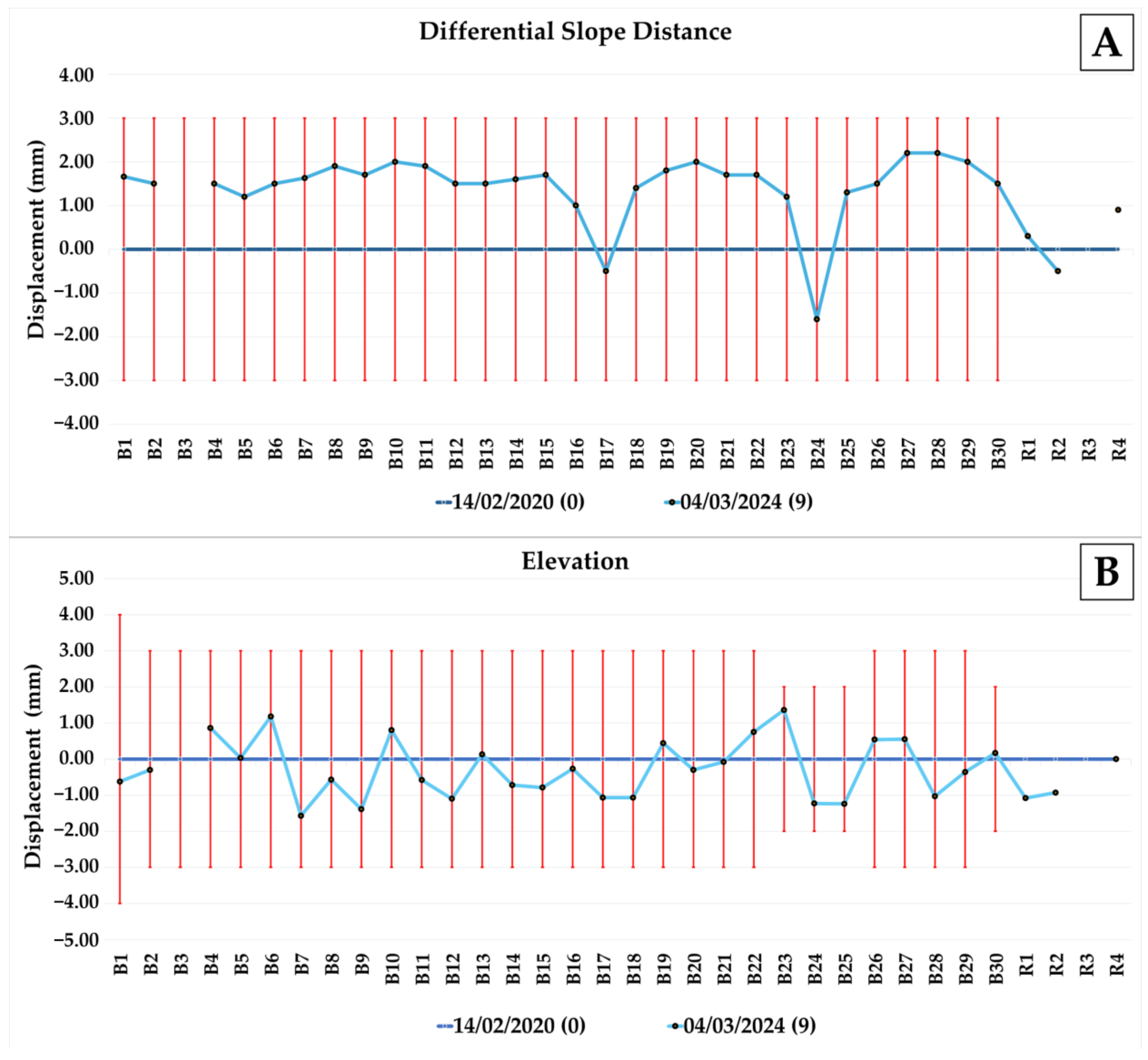
Finally, to validate the results obtained by this multitemporal monitoring, which was carried out from February 2020 to December 2021, on 4 March 2024, after two and a half years, a new RTS measurement campaign was carried out using the same settings and prisms. Figure 20 shows the results of this additional survey in terms of differential slope distance (Figure 20A) and elevation displacement (Figure 20B) as computed with respect to Survey n.0.
This additional measurement represents further proof of the stability of the monitoring prisms and, therefore, of the rock walls. The diagrams in Figure 20 show that the monitoring prism B3 and the reference prism R3 were not measured by the RTS. For the latter, there is not a valid and proven explanation of what causes this because the prism is clearly visible from the RTS, and it is not damaged or moved, while the monitoring prism B3 is hampered by the growth of natural vegetation within the line of sight from the RTS.
In light of the obtained results, a few limitations can also be pointed out: (i) the choice of the monitoring system, RTS surveys, provides precise measurements investigating only specific points and makes it hard to detect rock mass movements across the whole slope; (ii) the multitemporal nature of the data collection implies some events could be possibly missed between surveys; (iii) operational errors may occur in multitemporal RTS setup; (iv) environmental factors, like changing weather conditions, can affect the RTS measurement accuracy, particularly for more distant prisms. Finally, the PSI analysis, despite its help in monitoring areas at the top of the slope edge not visible from the RTS base, struggles in vegetated areas characterized by complex morphology.

6. Conclusions

The synergistic integration of RTS surveys and PSI analysis in this work has been proven as a powerful and comprehensive approach to slope stability monitoring in rockfall-prone areas. RTS excels in providing high-precision point measurements, enabling the accurate surveillance of specific locations and structures. PSI complements RTS by offering frequent and regular temporal monitoring, allowing for the detection of subtle changes over time and providing expansive coverage for monitoring large-scale ground deformations across large areas, including phenomena such as subsidence and slope deformations.
The automation capabilities inherent in both RTS and PSI could further enhance the efficiency of land deformation monitoring, reducing the need for manual intervention in data collection and enabling more frequent and consistent observations. The association of traditional engineering–geological surveys, UAS photogrammetry, slope stability analysis, RTS multitemporal surveys, and PSI analysis results in a holistic and dynamic monitoring framework that leverages the unique strengths of each method. This comprehensive approach not only ensures the accuracy of single-point measurements but also captures the nuanced temporal changes and large-scale deformations crucial for a thorough understanding of the monitored area that is classified by the Local Authority as high and very high rockfall hazard: thanks to this work’s results, the process of reducing the hazard level has started.
Successful implementation requires careful consideration of the specific characteristics of the monitoring site and the objectives of the study. The optimization of these technologies involves a thoughtful balance harnessing the precision of RTS and the temporal and spatial coverage of PSI to address the diverse challenges posed by ground deformations. As we navigate the evolving landscape of geodetic monitoring, the coupling of traditional methods with advanced technologies marks a significant stride towards achieving a more robust and insightful understanding of deformation processes, thereby contributing to the resilience and sustainable management of our built and natural environments.

Author Contributions

Conceptualization, L.B., A.R., C.V. and R.S.; methodology, L.B., A.R., C.V. and R.S.; software, L.B., A.R. and C.V.; validation, L.B., A.R. and R.S.; formal analysis, L.B., A.R., C.V. and R.S.; investigation, L.B., A.R., C.V. and R.S.; resources, R.S.; data curation, L.B., A.R., C.V. and R.S.; writing—original draft preparation, L.B. and R.S.; writing—review and editing, L.B., A.R. and R.S.; visualization, L.B. and R.S.; supervision, R.S.; project administration, R.S.; funding acquisition, R.S. All authors have read and agreed to the published version of the manuscript.

Funding

This research was funded by the Tuscany and Umbria Regional Directorate of the State Property Agency.

Data Availability Statement

The original contributions presented in the study are included in the article, further inquiries can be directed to the corresponding author.

Acknowledgments

We would like to thank the Tuscany and Umbria Regional Directorate of the Italian Public Property Agency for the authorization of data publication and the Società Acque SpA for allowing the installation of the RTS platform on their building. In addition, we would also like to thank Lorenzoni V. for support during the engineering–geological survey and De Lucia V., Ermini A., Giovannini R., and Silvestri D. for their support of the research.

Conflicts of Interest

The authors declare no conflicts of interest.

References

  1. Varnes, D.J. Slope movement types and processes. In Special Report 176: Landslides: Analysis and Control; Schuster, R.L., Krizek, R.J., Eds.; TRB, National Research Council: Washington, DC, USA, 1978; pp. 11–33. [Google Scholar]
  2. Cruden, D.M.; Varnes, D.J. Landslide types and processes. In Landslides, Investigation and Mitigation; Turner, A.K., Schuster, R.L., Eds.; Transport Research Board, National Research Council: Washington, DC, USA, 1996. [Google Scholar]
  3. Hungr, O.; Leroueil, S.; Picarelli, L. The Varnes classification of landslide types, an update. Landslides 2014, 11, 167–194. [Google Scholar] [CrossRef]
  4. Briones-Bitar, J.; Carrión-Mero, P.; Montalván-Burbano, N.; Morante-Carballo, F. Rockfall Research: A Bibliometric Analysis and Future Trends. Geosciences 2020, 10, 403. [Google Scholar] [CrossRef]
  5. Wang, M.; Cao, X.; Qiao, L. Comprehensive analysis of hazardous rock mass and simulation of potential rockfall processes using 3D terrain model: A case study of the high cut slope near damsite of a hydropower station in southern China. Chin. J. Geol. Hazard Control. 2023, 34, 86–96. [Google Scholar]
  6. Konsolaki, A.; Vassilakis, E.; Kotsi, E.; Diakakis, M.; Mavroulis, S.; Petrakis, S.; Filis, C.; Lekkas, E. A Time-Series Analysis of Rockfall Evolution in a Coastal Region Using Remote Sensing Data. In Proceedings of the EGU General Assembly 2024, Vienna, Austria, 14–19 April 2024. [Google Scholar] [CrossRef]
  7. Caliò, D.; Mineo, S.; Pappalardo, G. Digital Rock Mass Analysis for the Evaluation of Rockfall Magnitude at Poorly Accessible Cliffs. Remote Sens. 2023, 15, 1515. [Google Scholar] [CrossRef]
  8. Schilirò, L.; Robiati, C.; Smeraglia, L.; Vinci, F.; Iannace, A.; Parente, M.; Tavani, S. An Integrated Approach for the Reconstruction of Rockfall Scenarios from UAV and Satellite-Based Data in the Sorrento Peninsula (Southern Italy). Eng. Geol. 2022, 308, 106795. [Google Scholar] [CrossRef]
  9. Notti, D.; Guenzi, D.; Lasaponara, R.; Giordan, D. Merging Historical Archives with Remote Sensing Data: A Methodology to Improve Rockfall Mitigation Strategy for Small Communities. Land 2022, 11, 1951. [Google Scholar] [CrossRef]
  10. Zhan, J.; Yu, Z.; Lv, Y.; Peng, J.; Song, S.; Yao, Z. Rockfall Hazard Assessment in the Taihang Grand Canyon Scenic Area Integrating Regional-Scale Identification of Potential Rockfall Sources. Remote Sens. 2022, 14, 3021. [Google Scholar] [CrossRef]
  11. Vanneschi, C.; Rindinella, A.; Salvini, R. Hazard Assessment of Rocky Slopes: An Integrated Photogrammetry—GIS Approach Including Fracture Density and Probability of Failure Data. Remote Sens. 2022, 14, 1438. [Google Scholar] [CrossRef]
  12. Robiati, C.; Eyre, M.; Vanneschi, C.; Francioni, M.; Venn, A.; Coggan, J. Application of Remote Sensing Data for Evaluation of Rockfall Potential within a Quarry Slope. ISPRS Int. J. Geo-Inf. 2019, 8, 367. [Google Scholar] [CrossRef]
  13. Pasternak, G.; Zaczek-Peplinska, J.; Pasternak, K.; Jóźwiak, J.; Pasik, M.; Koda, E.; Vaverková, M.D. Surface Monitoring of an MSW Landfill Based on Linear and Angular Measurements, TLS, and LIDAR UAV. Sensors 2023, 23, 1847. [Google Scholar] [CrossRef]
  14. Carlà, T.; Gigli, G.; Lombardi, L.; Nocentini, M.; Meier, L.; Schmid, L.; Wahlen, S.; Casagli, N. Real-Time Detection and Management of Rockfall Hazards by Ground-Based Doppler Radar. Landslides 2024, 21, 155–163. [Google Scholar] [CrossRef]
  15. Miles, C.; Gomez, F.; Rosenblad, B.L.; Fulks, J.; Loehr, J.E. Quantifying Measurement Capabilities of Ground-Based Interferometric Radar for Rockfall Hazard Applications. Geotech. Test. J. 2020, 43, 985–1002. [Google Scholar] [CrossRef]
  16. Janeras, M.; Lantada, N.; Núñez-Andrés, M.A.; Hantz, D.; Pedraza, O.; Cornejo, R.; Guinau, M.; García-Sellés, D.; Blanco, L.; Gili, J.A.; et al. Rockfall Magnitude-Frequency Relationship Based on Multi-Source Data from Monitoring and Inventory. Remote Sens. 2023, 15, 1981. [Google Scholar] [CrossRef]
  17. Romeo, S.; Cosentino, A.; Giani, F.; Mastrantoni, G.; Mazzanti, P. Combining Ground Based Remote Sensing Tools for Rockfalls Assessment and Monitoring: The Poggio Baldi Landslide Natural Laboratory. Sensors 2021, 21, 2632. [Google Scholar] [CrossRef]
  18. Chen, J.; Li, H.; Jiang, N.; Chen, Q.; Zhou, J. A Method for Automatic Assessment of Rockfall Susceptibility Based on High-Resolution Point Clouds. Rock Mech. Rock Eng. 2024, 57, 1717–1733. [Google Scholar] [CrossRef]
  19. Giacomini, A.; Thoeni, K.; Santise, M.; Diotri, F.; Booth, S.; Fityus, S.; Roncella, R. Temporal-Spatial Frequency Rockfall Data from Open-Pit Highwalls Using a Low-Cost Monitoring System. Remote Sens. 2020, 12, 2459. [Google Scholar] [CrossRef]
  20. Minardo, A.; Coscetta, A.; Porcaro, G.; Giannetta, D.; Bernini, R.; Zeni, L. Distributed optical fiber sensors for integrated monitoring of railway infrastructures. Struct. Monit. Maint. 2014, 1, 173–182. [Google Scholar] [CrossRef]
  21. Lalam, N.; Ng, W.P.; Dai, X.; Wu, Q.; Fu, Q. Analysis of Brillouin Frequency Shift in Distributed Optical Fiber Sensor System for Strain and Temperature Monitoring. In Proceedings of the 4th International Conference on Photonics, Optics and Laser Technology (PHOTOPTICS), Rome, Italy, 27–29 February 2016. [Google Scholar]
  22. Barrias, A.; Casas, J.R.; Villalba, S. A Review of Distributed Optical Fiber Sensors for Civil Engineering Applications. Sensors 2016, 16, 748. [Google Scholar] [CrossRef] [PubMed]
  23. Carlino, S.; Mirabile, M.; Troise, C.; Sacchi, M.; Zeni, L.; Minardo, A.; Caccavale, M.; Darányi, V.; De Natale, G.; Mcgonigle, A.; et al. Distributed-Temperature-Sensing Using Optical Methods: A First Application in the Offshore Area of Campi Flegrei Caldera (Southern Italy) for Volcano Monitoring. Remote Sens. 2016, 8, 674. [Google Scholar] [CrossRef]
  24. Minardo, A.; Catalano, E.; Coscetta, A.; Zeni, G.; Zhang, L.; Di Maio, C.; Vassallo, R.; Coviello, R.; Macchia, G.; Picarelli, L.; et al. Distributed Fiber Optic Sensors for the Monitoring of a Tunnel Crossing a Landslide. Remote Sens. 2018, 10, 1291. [Google Scholar] [CrossRef]
  25. Zhenglin, Z.; Gao, L.; Sun, Y.; Zhang, Q.; Zeng, P. Strain Transfer Law of Distributed Optical Fiber Sensor. Chin. J. Lasers 2019, 46, 0410001. [Google Scholar] [CrossRef]
  26. Lanciano, C.; Salvini, R. Monitoring of Strain and Temperature in an Open Pit Using Brillouin Distributed Optical Fiber Sensors. Sensors 2020, 20, 1924. [Google Scholar] [CrossRef] [PubMed]
  27. Lanciano, C.; Vanneschi, C.; Tufarolo, E.; Salvini, R. Distributed Optical Fiber Sensors and Terrestrial Laser Scanner Surveys for the Monitoring of an Underground Marble Quarry. Ital. J. Eng. Geol. Environ. 2021, 1, 117–125. [Google Scholar] [CrossRef]
  28. Salvini, R.; Vanneschi, C.; Riccucci, S.; Francioni, M.; Gullì, D. Application of an Integrated Geotechnical and Topographic Monitoring System in the Lorano Marble Quarry (Apuan Alps, Italy). Geomorphology 2015, 241, 209–223. [Google Scholar] [CrossRef]
  29. Racek, O.; Blahůt, J.; Hartvich, F. Observation of the Rock Slope Thermal Regime, Coupled with Crackmeter Stability Monitoring: Initial Results from Three Different Sites in Czechia (Central Europe). Geosci. Instrum. Methods Data Syst. 2021, 10, 203–218. [Google Scholar] [CrossRef]
  30. Auflič, M.J.; Herrera, G.; Mateos, R.M.; Poyiadji, E.; Quental, L.; Severine, B.; Peternel, T.; Podolszki, L.; Calcaterra, S.; Kociu, A.; et al. Landslide Monitoring Techniques in the Geological Surveys of Europe. Landslides 2023, 20, 951–965. [Google Scholar] [CrossRef]
  31. Blahůt, J.; Racek, O. Modern Methods of Rock Mass Characterisation and Rockfall Monitoring: A Review. In Landslides: Detection, Prediction and Monitoring; Springer eBooks: Berlin/Heidelberg, Germany, 2023; pp. 1–38. [Google Scholar] [CrossRef]
  32. Souza, B.; Benoît, J. Rockfall Motion Using a Smart Rock Sensor. Can. Geotech. J. 2024, 61, 802–819. [Google Scholar] [CrossRef]
  33. Dematteis, N.; Wrzesniak, A.; Allasia, P.; Bertolo, D.; Giordan, D. Integration of Robotic Total Station and Digital Image Correlation to Assess the Three-Dimensional Surface Kinematics of a Landslide. Eng. Geol. 2022, 303, 106655. [Google Scholar] [CrossRef]
  34. Çelik, M.A.; Gülersoy, A.E. Evaluation of Rock Fall Risk in Kilis (Turkey) City by Using GIS and Remote Sensing. Int. J. Comput. Exp. Sci. Eng. 2017, 3, 1–4. [Google Scholar]
  35. Castelli, M.; Torsello, G.; Vallero, G. Preliminary Modeling of Rockfall Runout: Definition of the Input Parameters for the QGIS Plugin QPROTO. Geosciences 2021, 11, 88. [Google Scholar] [CrossRef]
  36. Depountis, N.; Nikolakopoulos, K.; Kavoura, K.; Sabatakakis, N. Description of a GIS-Based Rockfall Hazard Assessment Methodology and Its Application in Mountainous Sites. Bull. Eng. Geol. Environ. 2019, 79, 645–658. [Google Scholar] [CrossRef]
  37. Wang, X.; Liu, H.; Sun, J. A New Approach for Identification of Potential Rockfall Source Areas Controlled by Rock Mass Strength at a Regional Scale. Remote Sens. 2021, 13, 938. [Google Scholar] [CrossRef]
  38. Wohlers, A.; Damm, B. Rockfall Vulnerability of a Rural Road Network—A Methodological Approach in the Harz Mountains, Germany. Geosciences 2022, 12, 170. [Google Scholar] [CrossRef]
  39. Pinto Santos, P.; Reyes-Carmona, C.; Pereira, S.; Sarro, R.; Martínez-Corbella, M.; Coll-Ramis, M.A.; Zêzere, J.L.; Mateos, R.M. Seasonal Rockfall Risk Analysis in a Touristic Island: Application to the Tramuntana Range (Mallorca, Spain). Int. J. Disaster Risk Reduct. 2024, 101, 104264. [Google Scholar] [CrossRef]
  40. El Miloudi, Y.; El Kharim, Y.; Bounab, A.; El Hamdouni, R. Effect of Rockfall Spatial Representation on the Accuracy and Reliability of Susceptibility Models (The Case of the Haouz Dorsale Calcaire, Morocco). Land 2024, 13, 176. [Google Scholar] [CrossRef]
  41. Mahmood, S.; Atique, F.; Rehman, A.; Mayo, S.M.; Ahamad, M.I. Rockfall Susceptibility Assessment along M-2 Motorway in Salt Range, Pakistan. J. Appl. Geophys. 2024, 222, 105312. [Google Scholar] [CrossRef]
  42. Peng, H.; Xie, Q.; Chen, B.; Tan, K.; Cao, Z.; Wu, B. Failure Mode of the Hazardous Diaozui Rock Mass of the Qutang Gorge in the Three Gorges Reservoir Area Based on a Three-Dimensional Numerical Analysis. Bull. Eng. Geol. Environ. 2024, 83, 100. [Google Scholar] [CrossRef]
  43. Massaro, L.; Forte, G.; De Falco, M.; Rauseo, F.; Santo, A. Rockfall Source Identification and Trajectory Analysis from UAV-Based Data in Volcano-Tectonic Areas: A Case Study from Ischia Island, Southern Italy. Bull. Eng. Geol. Environ. 2024, 83, 75. [Google Scholar] [CrossRef]
  44. Noël, F.; Nordang, S.F.; Jaboyedoff, M.; Digout, M.; Guerin, A.; Locat, J.; Matasci, B. Comparing Flow-R, Rockyfor3D and RAMMS to Rockfalls from the Mel de la Niva Mountain: A Benchmarking Exercise. Geosciences 2023, 13, 200. [Google Scholar] [CrossRef]
  45. Yuen, T.Y.P.; Weng, M.-C.; Fu, Y.-Y.; Lu, G.-T.; Shiu, W.-J.; Lu, C.-A.; Liu, C.-Y.; Chiu, C.-C.; Wen, T.-H. Assessing the impact of rockfall on a bridge by using hybrid DEM/FEM analysis: A case study in Central Taiwan. Eng. Geol. 2023, 314, 107000. [Google Scholar] [CrossRef]
  46. Angın, Z.; Karahasan, O.Ş. Evaluation of the Performance of Gabion Walls as a High-Energy Rockfall Protection System Using 3D Numerical Analysis: A Case Study. Appl. Sci. 2024, 14, 2360. [Google Scholar] [CrossRef]
  47. Agliardi, F.; Frattini, P.; Stock, G.M.; Tosi, T.; Lanfranconi, C.; Collins, B.D. Probabilistic rockfall hazard and risk analysis along the El Portal Road in Yosemite National Park (California, USA). In Proceedings of the EGU General Assembly 2024, Vienna, Austria, 14–19 April 2024. EGU24-9085. [Google Scholar] [CrossRef]
  48. Liu, G.; Zhong, Z.; Ma, K.; Bo, W.; Zhao, P.; Li, Y.; Zhang, Z.; Zhang, P. Field Experimental Verifications of 3D DDA and Its Applications to Kinematic Evolutions of Rockfalls. Int. J. Rock Mech. Min. Sci. 2024, 175, 105687. [Google Scholar] [CrossRef]
  49. Merla, G. Geologia dell’Appennino Settentrionale. Boll. Soc. Geol. Ital. 1952, 70, 95–382. [Google Scholar]
  50. Giannini, E.; Nardi, R. Geologia della zona nord—occidentale del Monte Pisano e dei Monti d’Oltre Serchio (prov. di Pisa e Lucca). Boll. Soc. Geol. Ital. 1965, 84, 198–270. [Google Scholar]
  51. Rau, A.; Tongiorgi, M. Il lembo mesozoico di Caprona- Uliveto Treme sul margine meridionale dei Monti Pisani: Tettonica e cenni di stratigrafia. Mem. Soc. Geol. Ital. 1969, 7, 1–24. [Google Scholar]
  52. Boccaletti, M.; Ficcarelli, G.; Manetti, P.; Turi, A. Analisi stratigrafiche, sedimentologiche e petrografiche delle formazioni mesozoiche della Val di Lima (Prov. di Lucca). Mem. Soc. Geol. Ital. 1969, 8, 847–922. [Google Scholar]
  53. Rau, A.; Tongiorgi, M. Geologia dei Monti Pisani a Sud-Est della valle del Guappero. Mem. Soc. Geol. Ital. 1974, 13, 227–408. [Google Scholar]
  54. Carosi, R.; Montomoli, C.; Pertusati, P.C.; Sarti, G.; Frassi, C.; Leoni, L. Note Illustrative della Carta Geologica d’Italia alla scala 1:50.000 Foglio 273—Pisa; LAC: Florence, Italy, 2021. (In Italian) [Google Scholar]
  55. D’Amato Avanzi, G.; Nardi, I. Indizi di neotettonica nei Monti d’Oltre Serchio: Faglie distensive recenti al bordo della pianura pisana e depositi ciottolosi a quota 170 metri. Boll. Soc. Geol. Ital. 1993, 112, 601–614. [Google Scholar]
  56. CISIS. ConveRgo, Version 2.04; CISIS: Rome, Italy, 2012; Available online: https://www.cisis.it/?page_id=3214 (accessed on 31 May 2024).
  57. Leica Geosystems AG. Leica Infinity, Version 3.4.2; Leica Geosystems AG—Part of Hexagon. 2021. Available online: https://leica-geosystems.com/products/gnss-systems/software/leica-infinity (accessed on 31 May 2024).
  58. SPH Engineering. UgCSTM Professional Desktop Drone Flight Planning Software, Version 4.18; Latvia. 2023. Available online: https://www.sphengineering.com/support (accessed on 31 May 2024).
  59. Agisoft LLC. Agisoft Metashape ProfessionalTM, Version 2.0.; Agisoft LLC: St. Petersburg, Russia, 2023; Available online: https://www.agisoft.com/ (accessed on 31 May 2024).
  60. CloudCompare. Version 2. 2021. Available online: http://www.cloudcompare.org/ (accessed on 31 May 2024).
  61. Bieniawski, Z.T. Engineering Rock Mass Classification; John Wiley and Sons: New York, NY, USA, 1989; p. 251. [Google Scholar]
  62. Romana, M. New adjustment ratings for application of Bieniawski classification to slopes. In Proceedings of the International Symposium on the Role of Rock Mechanics in Excavations for Mining and Civil Works. International Society of Rock Mechanics, Zacatecas, Mexico, 2–4 September 1985; pp. 49–53. [Google Scholar]
  63. Markland, J.T. A Useful Technique for Estimating the Stability of Rock Slopes When the Rigid Wedge Slide Type of Failure Is Expected; Interdepartmental Rock Mechanics Project, Imperial College of Science and Technology: London, UK, 1972; Volume 19, p. 10. [Google Scholar]
  64. Hoek, E.; Bray, J.W. Rock Slope Engineering, 3rd ed.; The Institution of Mining and Metallurgy: London, UK, 1981; pp. 257–270. [Google Scholar]
  65. Rocscience DipsTM: Graphical and Statistical Analysis of Orientation Data, Version 8.022. Available online: https://www.rocscience.com/software/dips (accessed on 31 May 2024).
  66. Crosetto, M.; Monserrat, O.; Cuevas-González, M.; Devanthéry, N.; Crippa, B. Persistent Scatterer Interferometry: A Review. ISPRS J. Photogramm. Remote Sens. 2016, 115, 78–89. [Google Scholar] [CrossRef]
  67. Garthwaite, M.C.; Nancarrow, S.; Hislop, A.; Thankappan, M.; Dawson, J.H.; Lawrie, S. The Design of Radar Corner Reflectors for the Australian Geophysical Observing System: A Single Design Suitable for InSAR Deformation Monitoring and SAR Calibration at Multiple Microwave Frequency Bands; Geoscience Australia: Symonston, ACT, Australia, 2015. [CrossRef]
  68. Hooper, A.; Zebker, H.; Segall, P.; Kampes, B. A New Method for Measuring Deformation on Volcanoes and Other Natural Terrains Using InSAR Persistent Scatterers. Geophys. Res. Lett. 2004, 31, L23611. [Google Scholar] [CrossRef]
  69. Foumelis, M.; Delgado Blasco, J.M.; Desnos, Y.-L.; Engdahl, M.; Fernandez, D.; Veci, L.; Lu, J.; Wong, C. Esa Snap—Stamps Integrated Processing for Sentinel-1 Persistent Scatterer Interferometry. In Proceedings of the IGARSS 2018—2018 IEEE International Geoscience and Remote Sensing Symposium, Valencia, Spain, 22–27 July 2018. [Google Scholar] [CrossRef]
  70. SNAP-ESA Sentinel Application Platform, Version v7.0.0. Available online: http://step.esa.int (accessed on 22 January 2022).
  71. Hooper, A. A Multitemporal InSAR Method Incorporating Both Persistent Scatterer and Small Baseline Approaches. Geophys. Res. Lett. 2008, 35, L16302. [Google Scholar] [CrossRef]
  72. Zhao, C.; Lu, Z.; Zhang, Q.; de la Fuente, J. Large-Area Landslide Detection and Monitoring with ALOS/PALSAR Imagery Data over Northern California and Southern Oregon, USA. Remote Sens. Environ. 2012, 124, 348–359. [Google Scholar] [CrossRef]
  73. Scaioni, M.; Longoni, L.; Melillo, V.; Papini, M. Remote Sensing for Landslide Investigations: An Overview of Recent Achievements and Perspectives. Remote Sens. 2014, 6, 9600–9652. [Google Scholar] [CrossRef]
  74. Fárová, K.; Jelének, J.; Kopačková-Strnadová, V.; Kycl, P. Comparing DInSAR and PSI Techniques Employed to Sentinel-1 Data to Monitor Highway Stability: A Case Study of a Massive Dobkovičky Landslide, Czech Republic. Remote Sens. 2019, 11, 2670. [Google Scholar] [CrossRef]
  75. ASF Data Search. search.asf.alaska.edu. Available online: https://search.asf.alaska.edu/#/ (accessed on 31 May 2024).
  76. Consorzio LaMMA. Geoportale della Difesa del Suolo della Regione Toscana. Available online: https://geoportale.lamma.rete.toscana.it/difesa_suolo/#/viewer/326 (accessed on 31 May 2024).
  77. Artese, S.; Perrelli, M. Monitoring a Landslide with High Accuracy by Total Station: A DTM Based Model to Correct for the Atmospheric Effects. Geosciences 2018, 8, 46. [Google Scholar] [CrossRef]
  78. Carvill, J. Mechanical Engineer’s Data Handbook; Butterworth-Heinemann: Oxford, UK, 1993. [Google Scholar]
  79. Afeni, T.B.; Cawood, F.T. Slope Monitoring using Total Station: What are the Challenges and How Should These be Mitigated? S. Afr. J. Geomat. 2013, 2, 41–53. [Google Scholar]
  80. Strozzi, T.; Teatini, P.; Tosi, L.; Wegmüller, U.; Werner, C. Land subsidence of natural transitional environments by satellite radar interferometry on artificial reflectors. J. Geophys. Res. Earth Surf. 2013, 118, 1177–1191. [Google Scholar] [CrossRef]
  81. Ferretti, A.; Savio, G.; Barzaghi, R.; Borghi, A.; Musazzi, S.; Novali, F.; Prati, C.; Rocca, F. Submillimeter accuracy of InSAR time series: Experimental validation. IEEE Trans. Geosci. Remote Sens. 2007, 45, 1142–1153. [Google Scholar] [CrossRef]
  82. Garthwaite, M.C. On the Design of Radar Corner Reflectors for Deformation Monitoring in Multi-Frequency InSAR. Remote Sens. 2017, 9, 648. [Google Scholar] [CrossRef]
  83. Czikhardt, R.; Van Der Marel, H.; van Leijen, F.J.; Hanssen, R.F. Estimating Signal-To-Clutter Ratio of InSAR Corner Reflectors from SAR Time Series. IEEE Geosci. Remote Sens. Lett. 2022, 19, 4012605. [Google Scholar] [CrossRef]
  84. Zerbini, S.; Richter, B.; Rocca, F.; Bordas, S.; Matonti, F. A Combination of Space and Terrestrial Geodetic Techniques to Monitor Land Subsidence: Case Study, the Southeastern Po Plain, Italy. J. Geophys. Res. Solid Earth 2007, 112, B05401. [Google Scholar] [CrossRef]
  85. Cigna, F.; Esquivel Ramírez, R.; Tapete, D. Accuracy of Sentinel-1 PSI and SBAS InSAR Displacement Velocities against GNSS and Geodetic Leveling Monitoring Data. Remote Sens. 2021, 13, 4800. [Google Scholar] [CrossRef]
  86. Shi, X.; Zhang, S.; Jiang, M.; Pei, Y.; Qu, T.; Xu, J.; Yang, C. Spatial and Temporal Subsidence Characteristics in Wuhan (China), during 2015–2019, Inferred from Sentinel-1 Synthetic Aperture Radar (SAR) Interferometry. Nat. Hazards Earth Syst. Sci. 2021, 21, 2285–2297. [Google Scholar] [CrossRef]
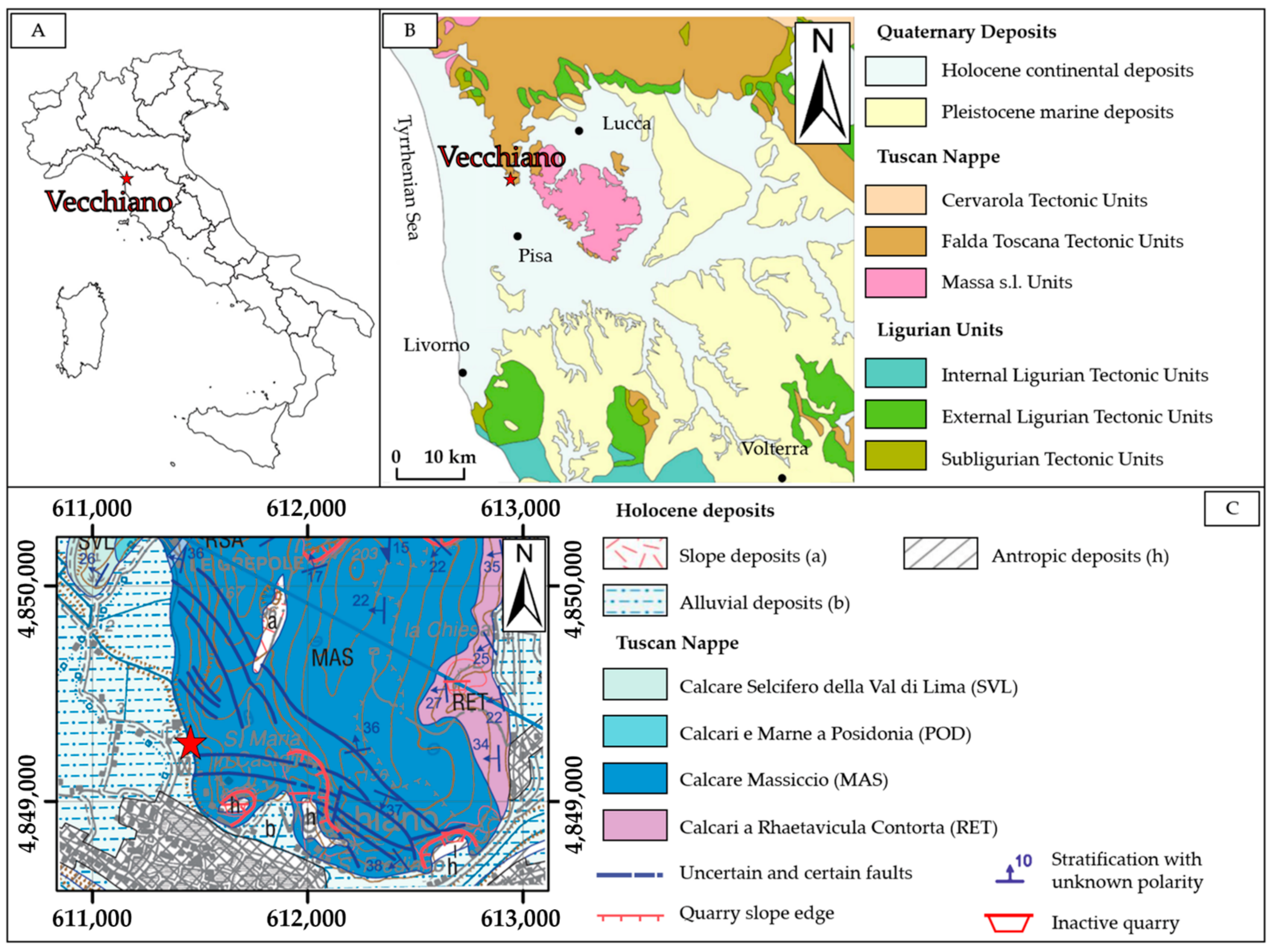
Figure 1. Geological framework of the study site. (A) The site location in Italy; (B) the regional geological framework (Sheet n.273 “Pisa”) modified from [54]; (C) a subset of the geological map n.273 “Pisa” [54]; the red star in (C) indicates the precise location of the study area.
Remotesensing 16 03848 g001
Figure 2. Overall methodology flowchart.
Remotesensing 16 03848 g002
Figure 3. Stages of the GNSS (A) and RTS surveys (B).
Remotesensing 16 03848 g003
Figure 4. Photos in (A,B) show some examples of outcrops selected for the in situ engineering–geological survey; the yellow dashed lines in (C) indicate the location of scanlines along the slope; the red boxes in (C) show the areas where discontinuity sampling was performed through CloudCompare software (version 2).
Remotesensing 16 03848 g004
Figure 5. Robotic Total Station (RTS) on the iron plate anchored to a reinforced concrete curb (A); view of the rock walls to be monitored from the RTS position (B); macroprism and microprism utilized for the RTS multitemporal surveys (C).
Remotesensing 16 03848 g005
Figure 6. Location of RTS base (in yellow) and prisms; green colors indicate the reference prisms utilized to orient the monitoring system; red colors indicate the monitoring prisms periodically measured during the nine surveys.
Remotesensing 16 03848 g006
Figure 7. Example of error ellipse for the B4 monitoring prism.
Remotesensing 16 03848 g007
Figure 8. Metallic corner reflectors installed on the top edge above the rocky walls: location of corner reflectors in the study area (A). Photos in CR1, CR2, and CR3 show detailed images of the corner reflectors.
Remotesensing 16 03848 g008
Figure 9. Satellite imagery covering the area of interest (A); satellite imagery spatially corresponding to the same area of interest (B). The yellow square shows the area of interest.
Remotesensing 16 03848 g009
Figure 10. Perspective view of the georeferenced and scaled 3D point cloud of the rocky walls; the scale bar only applies to (A). Georeferenced orthophotomosaic of the rocky walls and the alluvial plain (B).
Remotesensing 16 03848 g010
Figure 11. Stereographic projection (Schmidt equal-area method—lower hemisphere) of data collected during the in situ engineering–geological survey.
Remotesensing 16 03848 g011
Figure 12. Stereographic projection (Schmidt equal-area method—lower hemisphere) of data interpreted on the 3D point cloud.
Remotesensing 16 03848 g012
Figure 13. Slopes considered for the application of the SMR method and the following statistical kinematic stability analysis (Section 4.4). The stereographic projections (Wulff equal-angle method—lower hemisphere) show an example of the executed kinematic analysis (ex., wedge sliding).
Remotesensing 16 03848 g013
Figure 14. Planimetric representation of multitemporal monitoring results (monitoring prisms from B1 to B15). The error ellipses for the monitoring prisms are indicated in orange. The points, differentiated by color, indicate the 9 multitemporal surveys.
Remotesensing 16 03848 g014
Figure 15. Planimetric representation of multitemporal monitoring results (monitoring prisms from B16 to B30). The error ellipses for the monitoring prisms are indicated in orange. The points, differentiated by color, indicate the 9 multitemporal surveys.
Remotesensing 16 03848 g015
Figure 16. Differential slope distance (A) and elevation displacement (B) of each prism measured in all the RTS surveys. The uncertainty thresholds for each prism are indicated by the red vertical bars.
Remotesensing 16 03848 g016
Figure 17. Differential slope distance (A) and elevation displacement (B) of each prism as computed with respect to R4. The uncertainty thresholds for each prism are indicated by the red vertical bars.
Remotesensing 16 03848 g017
Figure 18. Results of the PSI analysis in terms of LOS velocities (mm/yr) for the Sentinel-1A (A) and Sentinel-1B data (B). The yellow squares represent the position of the artificial corner reflectors installed at the top of the rocky slopes in this work. The blue triangle indicates the building where the RTS is installed.
Remotesensing 16 03848 g018
Figure 19. PSs identified by the regional LaMMa interferometric service for the study area. The red circle identifies the point FV6XKKY located near the RTS. The diagram at the bottom of the map shows the trend of this PS LOS velocity (mm/yr) considering the same interval of the RTS monitoring time span. The light blue ellipses indicate the acquisition dates of the 7th and 8th RTS surveys.
Remotesensing 16 03848 g019
Figure 20. Differential slope distance (A) and elevation displacement (B) of each prism as measured during the survey carried out on 4 March 2024.
Remotesensing 16 03848 g020
Table 1. Summary of the final uncertainty threshold values for each monitoring prism.
Prism IDRTS to Prism Distance (m)Distance Uncertainty (±mm)Azimuthal Uncertainty (±mm)Elevation Uncertainty (±mm)
B1257374
B2252383
B3235363
B4212373
B5207343
B6209343
B7213343
B8207353
B9200353
B10203353
B11186333
B12167333
B13171353
B14172343
B15153343
B16133343
B17128333
B18143353
B19149333
B20152353
B21135333
B22119343
B2398332
B2499342
B25100352
B26149363
B27159353
B28164373
B29167373
B30103352
Table 2. Information on the SAR data utilized in the PSI analysis.
SatelliteFirst and Last Scene DateAcquisition OrbitPath nr.Frame nr.Utilized Images
Sentinel-1A30 July 2020–21 January 2022Ascending1513944
Sentinel-1B5 August 2020–22 December 2021Ascending1513737
Table 3. Engineering–geological parameters of the identified discontinuity systems.
SystemK1K1aK2aK2bK3K4
Dip direction/Dip (°)288/82124/7832/79203/82227/4069/30
Aperture (mm)>5>5>5>51–51–5
Length (m)3–103–101–31–3<1<1
Spacing (m)1.21.2<1<10.800.50/1
Surface weatheringSlightly
weathered
Slightly
weathered
Un-weatheredUn-weatheredSlightly
weathered
Un-weathered
Filling (type)CleanCleanCleanCleanCleanSoft filling
RoughnessRoughRoughRoughRoughRoughSlightly rough
JRC16–1816–1810–1214–1610–126–8
HumidityDryDryDryDryDryDry
R-value (intact rock)474749495354
Table 4. Results of the SMR method application with reference to the six analyzed slopes, as shown in Figure 13. (P = planar failure, W = wedge failure, and T = toppling).
Discontinuity SystemV1V2V3
Failure TypePWTPWTPWT
K1 288/8245 *7883808083678083
K1a 124/78807877807883808666
K2a 32/79807883807883807883
K2b 203/82808083808083808083
K3 227/40798183678683797983
K4 69/30838686838681838686
Discontinuity SystemV4V5V6
Failure TypePWTPWTPWT
K1 288/82808166878083878383
K1a 124/78676383877883878177
K2a 32/79808083878083877883
K2b 203/82808083876783876283
K3 227/4079818367838736 *7987
K4 69/30838686838687638687
* Superscript stars indicate the minimum resulting values.
Table 5. Results obtained from the statistical kinematic stability analysis.
Slope Planar SlidingWedge SlidingDirect TopplingFlexural Toppling
Critical PlaneCritical IntersectionCritical Intersection
280/88K1–K2b–K3K1/K2b–K1/K2a–K1/K3 (on K3)–
K1/K1a (on K1)–K1a/K3 (on K1a)
K1a/K2a–K2a/K4–K2b/K4–K2a/K2b–
K1a/K2b (Oblique Toppling)
250/88K1–K2b–K3K1/K2b–K1/K3 (on K3)–K1/K1a (on K1a)–K1a/K3 (on K1a)K1a/K2a–
K1/K1a–K1a/K2b (Oblique Topping)
310/85K1–K3K1/K2a–K1/K2b–K1/K4 (on K1)K1a/K2b–K2a/K2b–K2a/K4–K2b/K4–K3/K4–
K1a/K2a (Oblique Toppling)
K1a
100/85K1a–K2aK1a/K2a–K1a/K2b–K1a/K4 (on K1a)K2b/K3–
K1/K2a–K1/K2b (Oblique Toppling)
K1
250/65K3K1a/K3 (on K1a)–K1/K3–K1/K1a (on K1)K1a/K2a–
K1/K2a–K1a/K2b (Oblique Toppling)
280/65K3 K1a/K2a–K2a/K2b–
K1a/K2b (Oblique Toppling)
Table 6. Summary of the average precision values for each RTS monitoring survey.
RTS SurveySlope Distance Precision (±mm)Azimuthal Angle Precision (±″)Zenithal Angle Precision (±″)
00.21.81.5
10.12.20.9
20.22.51.1
30.11.61.0
40.13.71.3
50.13.11.5
60.24.21.1
70.24.11.1
80.11.11.1
Disclaimer/Publisher’s Note: The statements, opinions and data contained in all publications are solely those of the individual author(s) and contributor(s) and not of MDPI and/or the editor(s). MDPI and/or the editor(s) disclaim responsibility for any injury to people or property resulting from any ideas, methods, instructions or products referred to in the content.