Article

Estimating Grassland Carrying Capacity in the Source Area of Nujiang River and Selinco Lake, Tibetan Plateau (2001–2020) Based on Multisource Remote Sensing

1
College of Earth and Environmental Sciences, Lanzhou University, Lanzhou 730000, China
2
Center for Remote Sensing of Ecological Environments in Cold and Arid Regions, Lanzhou University, Lanzhou 730000, China
3
State Key Laboratory of Efficient Utilization of Arid and Semi-Arid Arable Land in Northern China, Institute of Agricultural Resources and Regional Planning, Chinese Academy of Agricultural Sciences, Beijing 100081, China
*
Author to whom correspondence should be addressed.
Remote Sens. 2024, 16(20), 3790; https://doi.org/10.3390/rs16203790
Submission received: 27 August 2024 / Revised: 9 October 2024 / Accepted: 10 October 2024 / Published: 12 October 2024
(This article belongs to the Section Ecological Remote Sensing)

Abstract

:
Estimating the spatiotemporal variations in natural grassland carrying capacity is crucial for maintaining the balance between grasslands and livestock. However, accurately assessing this capacity presents significant challenges due to the high costs of biomass measurement and the impact of human activities. In this study, we propose a novel method to estimate grassland carrying capacity based on potential net primary productivity (NPP), applied to the source area of the Nujiang River and Selinco Lake on the Tibetan Plateau. Initially, we utilize multisource remote sensing data—including soil, topography, and climate information—and employ the random forest regression algorithm to model potential NPP in areas where grazing is banned. The construction of the random forest model involves rigorous feature selection and hyperparameter optimization, enhancing the model’s accuracy. Next, we apply this trained model to areas with grazing, ensuring a more accurate estimation of grassland carrying capacity. Finally, we analyze the spatiotemporal variations in grassland carrying capacity. The main results showed that the model achieved a high level of precision, with a root mean square error (RMSE) of 4.89, indicating reliable predictions of grassland carrying capacity. From 2001 to 2020, the average carrying capacity was estimated at 9.44 SU/km2, demonstrating a spatial distribution that decreases from southeast to northwest. A slight overall increase in carrying capacity was observed, with 65.7% of the area exhibiting an increasing trend, suggesting that climate change has a modest positive effect on the recovery of grassland carrying capacity. Most of the grassland carrying capacity is found in areas below 5000 m in altitude, with alpine meadows and alpine meadow steppes below 4750 m being particularly suitable for grazing. Given that the overall grassland carrying capacity remains low, it is crucial to strictly control local grazing intensity to mitigate the adverse impacts of human activities. This study provides a solid scientific foundation for developing targeted grassland management and protection policies.

1. Introduction

Grassland, a vital component of terrestrial ecosystems, is crucial for biodiversity conservation, global carbon sequestration, water retention, and soil preservation [1,2]. Additionally, grassland serves as a crucial area for grazing and food production, offering significant material support for the advancement of agriculture and livestock management [3,4]. Alpine grassland on the Tibetan Plateau is widely distributed and constitutes the largest alpine grassland system in the world. Due to the harsh alpine conditions, grassland ecosystems are exceptionally sensitive and fragile [5,6]. Climate change, land use alterations, and localized overgrazing have profoundly jeopardized the integrity and stability of grassland ecosystems in the region, leading to varying degrees of degradation of previously fragile landscapes [7,8]. The source area of Nujiang River and Selinco Lake (the Selinco Region) exemplifies the alpine grassland of the Tibetan Plateau. As a central component of the Asian Water Tower, the Selinco Region is not only a vital expanse of pristine pasture on the Tibetan Plateau but also a crucial area in the construction of ecological security barriers across the Tibetan Plateau [9]. A healthy and stable grassland ecosystem in this area will significantly benefit the sustainable development of the regional economy and the preservation of ecological security on the Tibetan Plateau.
Grassland carrying capacity forms the cornerstone of grassland conservation. Accurate and reasonable estimation of this capacity is crucial for addressing issues of grass-livestock imbalance, ensuring sustainable grassland use, and maintaining the health and stability of grassland ecosystems. Currently, grassland carrying capacity is primarily assessed based on the reasonable livestock capacity, which represents the maximum number of animals that the grassland can support without compromising the stability of the ecosystem [10,11]. The standard “Calculation of Reasonable Livestock Carrying Capacity of Natural Grassland” (NY/T6352015) [12], proposed by the Department of Animal Husbandry, Ministry of Agriculture of China, outlines the method for calculating the reasonable livestock carrying capacity of natural grassland in China. It details crucial parameters such as edible pasture yield, optimal grassland utilization rate, and sheep units, serving as pivotal metrics for determining the carrying capacity of Chinese grasslands, particularly for small-scale sample areas. In previous studies, the primary methods for estimating grassland carrying capacity include field measurements and remote sensing simulation. The measured method, which entails ground-based measurements of forage production in small areas [13], is known for its accuracy but requires significant time, effort, and financial resources. In recent years, the enhanced availability and quality of optical time series data streams have driven their widespread use in monitoring vegetation productivity metrics, such as NPP and NDVI [14]. Remote sensing methods that utilize these indices to model grassland carrying capacity provide high spatiotemporal resolution, enabling precise estimates over extensive temporal and spatial scales [15,16]. This approach has gained broad adoption, highlighting its utility in capturing detailed insights into vegetation dynamics and ecosystem health. The NDVI estimation method requires establishing a regression relationship between measured sample point data and vegetation indices like NDVI to simulate grassland carrying capacity in a region. This method often demands a large number of representative sample points across both time and space to ensure accuracy. Conversely, NPP is a key indicator of ecosystem productivity and quality [17,18,19]. The NPP estimation method simplifies the process by using the empirical relationship between NPP and biomass to estimate grassland carrying capacity, ensuring accuracy while significantly reducing complexity. This method is particularly suited for grassland carrying capacity research in areas where obtaining extensive sample points is challenging.
As the direct impacts of human activities on natural ecosystems become increasingly pronounced, distinguishing between the effects of climate change and those of human activities has become more challenging. Most studies on grassland carrying capacity rely on actual NPP, which reflects the combined influences of climate change and human activities. Few studies, however, isolate the effects of climate change from those of human activities [16]. Isolating the impacts of human activities on grassland carrying capacity provides a more accurate assessment of the grassland carrying capacity under natural conditions. This approach also facilitates more precise predictions of how grassland carrying capacity may evolve under future climate scenarios. Recent evidence shows that the Tibetan Plateau has experienced more pronounced climate changes compared to other regions of China [20]. Furthermore, the Tibetan Plateau has warmed at a rate more than twice the global average [21] and has seen a modest increase in precipitation [22]. In light of these changes, it is crucial to conduct a thorough investigation into the specific effects of climate change on the grassland carrying capacity of the Tibetan Plateau. A comprehensive analysis of these impacts will provide valuable insights into how climate change influences grassland carrying capacity. Potential natural vegetation (PNV) is defined as vegetation that develops under natural succession processes without direct human intervention. It provides a reliable depiction of the relationship between climate and vegetation [23,24]. Potential NPP refers to the maximum productivity of vegetation under optimal growth conditions, where factors such as soil, nutrients, and carbon dioxide are at ideal levels, with light, heat, and water being the only limiting factors [25]. Potential NPP serves as an indicator of the efficient use of climate resources [26] and is crucial for forecasting future vegetation growth and productivity constraints [27]. Simulating the spatial and temporal patterns of potential vegetation NPP under climate change and assessing the corresponding changes in grassland carrying capacity can facilitate adaptation strategies and the development of targeted management policies for grassland ecosystems.
Estimating grassland carrying capacity is challenging in areas that are already subjected to grazing. Observed NPP in such areas reflects the actual biomass, which may be significantly lower than the potential biomass due to overgrazing. Therefore, using observed NPP directly can lead to an underestimation of the true carrying capacity. To address this issue, this study uses the Selinco Region on the Tibetan Plateau as a case study to propose a novel method for estimating grassland carrying capacity. We model potential NPP in areas where grazing is banned and then apply this trained model to areas with grazing, ensuring a more accurate estimation of grassland carrying capacity. The aim is to assess the spatial-temporal distribution of grassland carrying capacity under natural conditions, based on potential vegetation and potential NPP. This research provides a scientific basis for assessing the impact of climate change on grassland carrying capacity. It also contributes to the development of targeted adaptation strategies to protect and restore grassland ecosystems in the Selinco Region, promoting sustainable development of pastoralism while effectively utilizing climate resources.

2. Data and Processing

2.1. Study Area

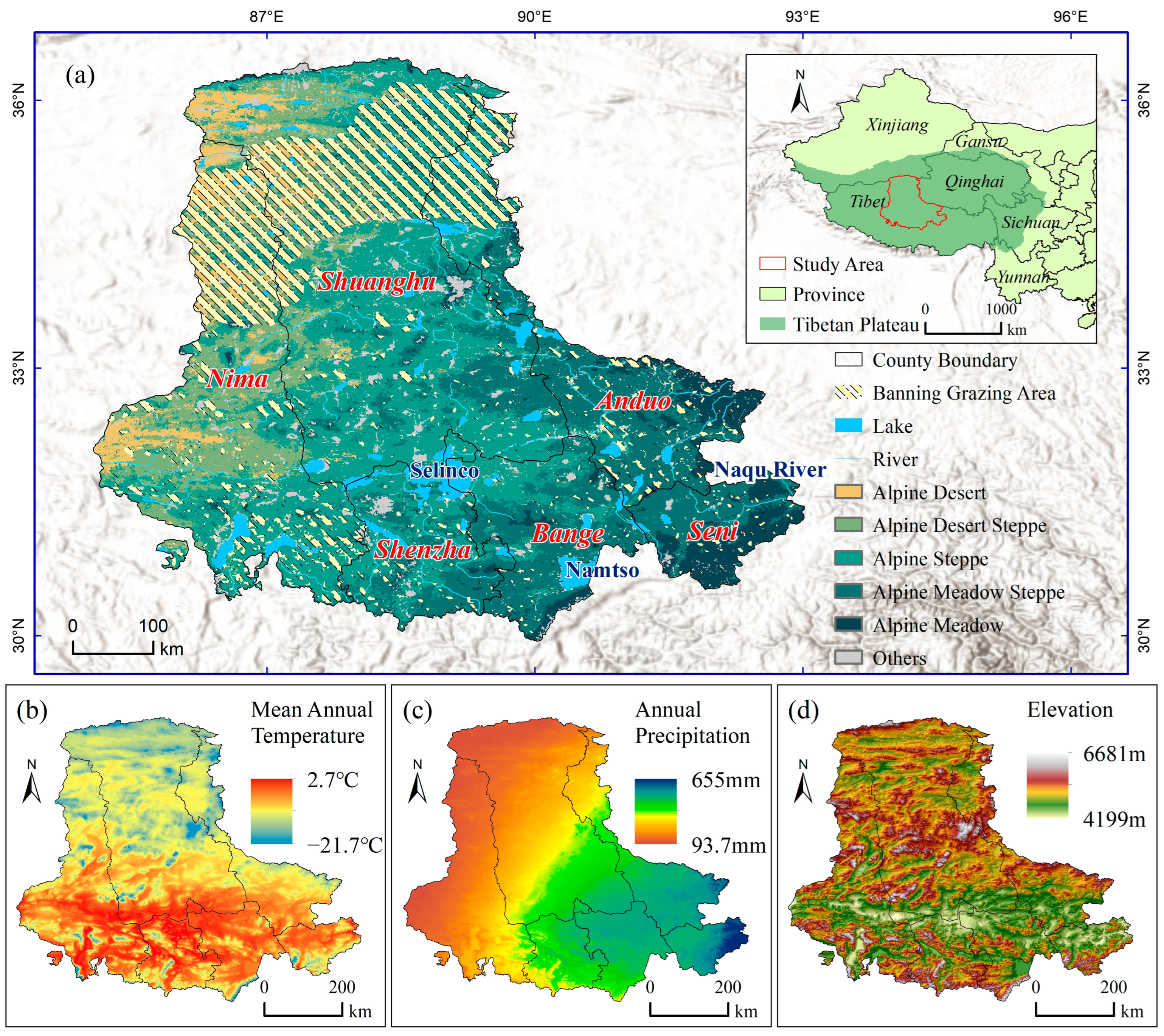
The Selinco Region, situated in the hinterland of the Tibetan Plateau (Figure 1), is both the origin of the internationally significant Nujiang (Salween) River and the site of Tibet’s largest saline lake, Selinco Lake. This region, positioned between 85°03′ and 93°01′E longitude and 29°56′ and 36°29′N latitude, spans an area of 303,600 km2. It encompasses six counties in the western part of Naqu city: Seni, Anduo, Shenzha, Bange, Nima, and Shuanghu [28]. The region is located between the Kunlun Mountains, Nyainqntangla Mountains and Kailas Range, with an average elevation of more than 4500 m. The total elevation gradually increases from southeast to northwest, and a unique geomorphological pattern of alpine and upland plains and hills has been formed by a long period of crustal movement and wind and rain erosion [29]. The overall climate of the region is cold and dry, with the average temperature of the warmest month below 10 °C, the average temperature of the coldest month below −10 °C in most areas, and the average monthly temperature below 0 °C for more than six months of the year. Average annual precipitation ranges from 100 to 500 mm, with precipitation concentrated mainly in May to September, and precipitation decreases as the region gradually transitions from the humid and semi-humid zone in the southeast to the arid zone in the northwest. The main vegetation type in the region is natural grassland. Grazing is the most dominant human activity in the region [30], which profoundly influences the socio-economic development of the region and the construction of the regional ecological environment.

2.2. Data

To accurately estimate grassland carrying capacity, this study employed a comprehensive dataset encompassing vegetation, climate, topography, soils, and land use. This integrated approach enhances the precision of estimating potential NPP and determining the optimal livestock carrying capacity.

2.2.1. NPP Data

The NPP data selected for this study are derived from the Terra MODIS satellite, which is known for its ability to monitor large-scale environmental changes and vegetation dynamics. We specifically utilized the MOD17A3HGF data product, which effectively captures the spatial and temporal characteristics of NPP across various biota. This dataset is recognized for its high spatial resolution, timeliness, and accessibility [31] and has demonstrated reliability in estimating carrying capacity [11,32]. The MOD17A3HGF annual NPP data integrates cumulative 8-day values at a 500 m resolution, calculated based on the radiation use efficiency principle, representing the difference between Gross Primary Production (GPP) and maintenance respiration. Notably, compared to the MOD17A3 data product, MOD17A3HGF employs a blank-filling methodology that significantly enhances data quality by mitigating contamination and employing linear interpolation for improved accuracy [33].
In this study, annual NPP data at 500 m resolution from 2010 to 2020 were resampled to 1 km to ensure consistency with the majority of the feature variables used in the potential NPP simulation and subsequently filtered using the banned grazing area data. These areas include the core zones of the Qiangtang National Nature Reserve and other areas designated by local government departments [29], where human activities are severely restricted. It is assumed in this study that vegetation in the banned grazing area is minimally affected by human disturbance, making the observed NPP (ONPP) closely approximate the potential NPP.

2.2.2. Climate Data

Temperature, precipitation, solar radiation, air dryness, and humidity are major climatic factors influencing vegetation growth. It has been demonstrated that temperature, precipitation, and photosynthetically active radiation serve as the energy bases for terrestrial ecosystems and are primary drivers of vegetation change [34]. Drought is identified as a key factor limiting productivity in the alpine meadow of the northern Qinghai-Tibetan Plateau [35], while climatic variability rather than grazing activity predominantly influences vegetation changes on the Tibetan Plateau.
Therefore, in this study, we selected 10 climate factors to simulate the potential NPP from 2001 to 2020. These factors include mean temperature, maximum temperature, minimum temperature, cumulative precipitation, relative humidity, potential evapotranspiration, solar downward shortwave radiation, the Palmer drought severity index, and the vapor pressure deficit. The data were resampled to 1 km resolution using datasets from the China Meteorological Data Center (http://www.geodata.cn, accessed on 20 February 2024) and the University of Idaho’s gridded surface meteorological dataset available in Google Earth Engine (IDAHO_EPSCOR/GRIDMET) [36].

2.2.3. Terrain Data

On a localized scale, topography significantly influences the spatial distribution of vegetation [37]. We utilized the Shuttle Radar Topography Mission (SRTM) digital elevation data provided by NASA JPL with a spatial resolution of 30 m. Using the Google Earth Engine platform, we computed slope and aspect based on the SRTM data, resampling them to 1 km resolution. These calculations served as inputs for topographic features in potential NPP simulations.

2.2.4. Soil Data

Soil serves as the foundation for vegetation growth, providing water and nutrients [38,39]. In this study, we selected 12 soil physicochemical properties at 1 km resolution, including shallow soil bulk density, pH, organic carbon content, clay content, silt content, sand content, total potassium, total nitrogen, total phosphorus, available potassium, available nitrogen, and available phosphorus. These data were sourced from the National Center for Earth System Science Data (http://www.geodata.cn, accessed on 25 February 2024) and the Sun Yat-sen University Land–Air Interaction Research Group (http://globalchange.bnu.edu.cn/research/data, accessed on 24 February 2024).
Soil temperature and soil moisture, which can have a greater impact on vegetation than meteorological factors [40,41], were also included in this study. Data at 0.1° × 0.1° resolution were resampled to 1 km to complement soil properties. These datasets were obtained from the European Centre for Medium-Range Weather Forecasts Fifth-Generation Land Surface Reanalysis Dataset (ERA5-Land).

2.2.5. Land-Use Data

In this study, multi-period 1-km resolution land use data were used to delineate the spatial distribution of grassland. The dataset used, named the China Multi-period Land Use Remote Sensing Monitoring Dataset (CNLUCC), is derived from Landsat satellite imagery and is constructed through visual interpretation by the Chinese Academy of Sciences. The dataset was sourced from the Resource and Environmental Science Data Center (http://www.resdc.cn/DOI, accessed on 22 February 2023). Previous studies have demonstrated that the overall accuracy of this land use classification exceeds 93% [42,43].
The data list is presented in Table 1.
The resolution of 1 km is appropriate for the spatial and temporal distribution studies of our study area. We used 1 km resampling for different types of data to ensure consistency in data resolution, which helps maintain the reliability and comparability of various datasets.

3. Methodology

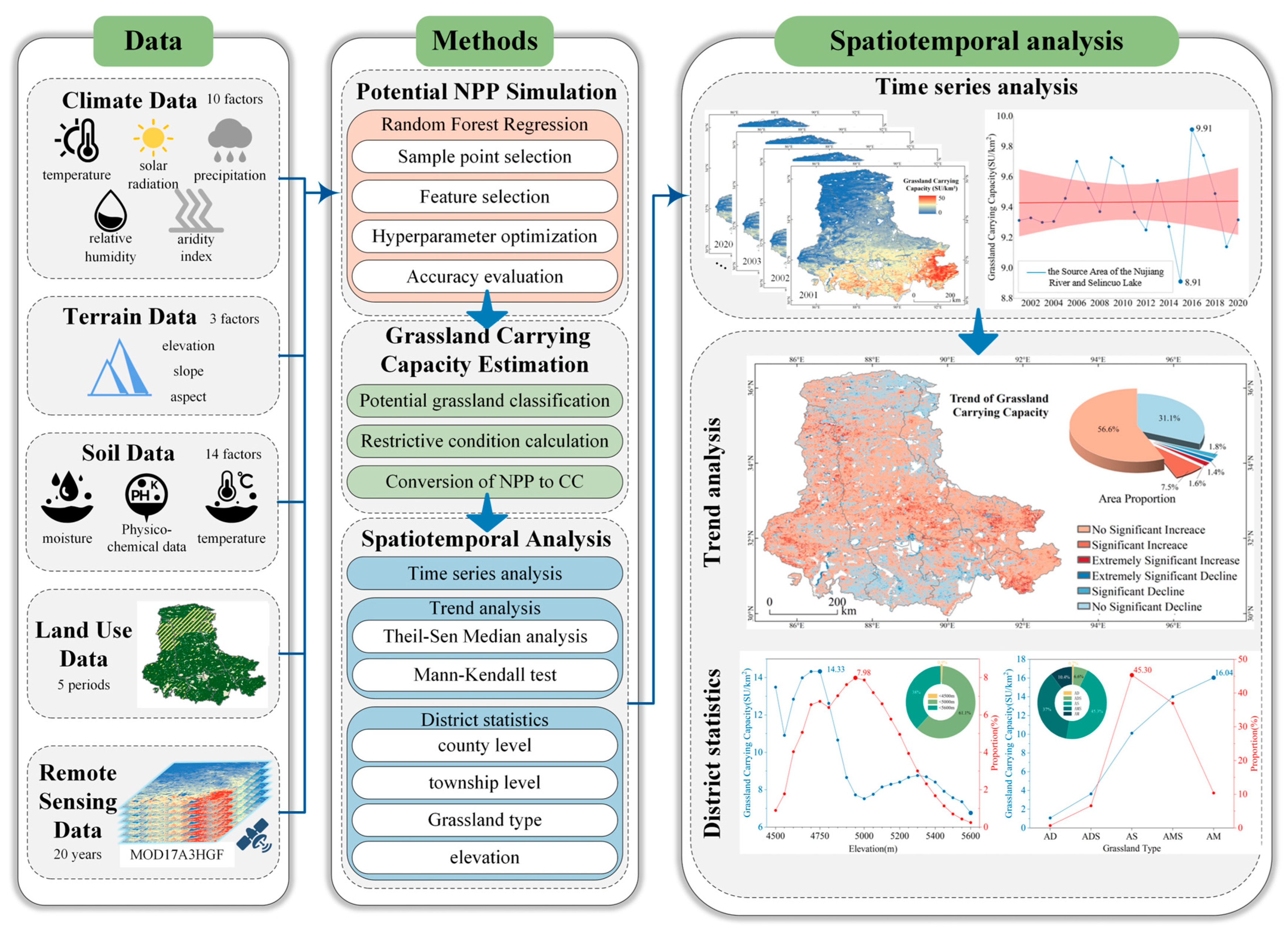
The general research process is illustrated in Figure 2. Initially, the key natural factors influencing vegetation growth were identified, and the potential NPP in banning grazing area from MODIS remote sensing data was modeled as a function of these key natural factors using an optimized random forest regression algorithm. This trained model was then applied to grazed areas to estimate their potential NPP, avoiding inconsistencies between MODIS observations and potential NPP in grazing areas and ensuring that human grazing activities do not distort the estimation of grassland carrying capacity. Subsequently, potential grassland distributions were modeled, and various factors limiting grassland carrying capacity were evaluated. Finally, grassland carrying capacity was estimated and subjected to spatiotemporal analysis to reveal its patterns of variation over time and space.

3.1. Classification of Potential Grassland

The Chinese Vegetation-Habitat Grassland Classification uses a combination of grassland vegetation characteristics and multi-habitat factors as the grassland classification standard, which was formally recognized as the “Standard for the Classification of Grassland Types and the Classification System of Grassland Types in China”, and classifies grassland in China into 18 categories, including alpine meadow, alpine meadow steppe, alpine typical grassland, alpine desert grassland, and alpine desert grassland [44], which were harmonized with the grassland types in “NY/T6352015”. “NY/T6352015” includes parameters for calculating the carrying capacity of different grassland types, making it essential for our grassland classification to align with the grassland types specified in the standard. The grassland classification standard and classification system used the thermal condition and moisture status to classify the grassland types. The moisture status was quantified by Ivanov’s wetness index [44]. The formula for calculating Ivanov’s wetness and its correspondence with grassland types (Table 2) are shown below:
K = 1 12 i R i E i = 1 12 i R i 0.0018 × ( 25 + T i ) 2 × ( 100 F i ) .
where K is the Ivanov wetness, R is the average monthly precipitation, E is the average monthly evaporation, T is the average monthly air temperature, and F is the average monthly relative humidity.
Since the Selinco Region is one of the highest-altitude regions in the world, with elevations exceeding 4000 m, and experiences cold temperatures year-round, this study classifies the grasslands in the Selinco Region into five categories: alpine desert, alpine desert steppe, alpine steppe, alpine meadow steppe, and alpine meadow.
To address the significant volatility in the wetness indicator over time and to reduce the impact of annual fluctuations, this study applied a 20-year averaging window to determine Ivanov’s wetness for the period from 2001 to 2020. Based on this smoothed data, we generated a distribution map of potential grassland classifications for the specified time frame (Figure 1a).

3.2. Potential NPP Simulation

The process of constructing a potential NPP model using random forest regression involves several key steps: sample point selection, feature selection and processing, model building, and accuracy evaluation. For this study, samples were annually collected from the banned grazing area between 2010 and 2020, resulting in approximately 96,000 samples. These were randomly split, with 80% used for training and the remaining 20% for testing the model.
To avoid information redundancy and noise, which can increase computational costs and affect model accuracy, it is crucial to perform feature selection and processing before training multi-feature models. Table 3 lists the original 27 model input features. In this study, we employed the forward feature selection method to select the features. Initially, features were ranked based on their importance in the random forest model. Subsequently, features were added gradually to an empty set, and model performance was evaluated at each step until optimal model performance was achieved.
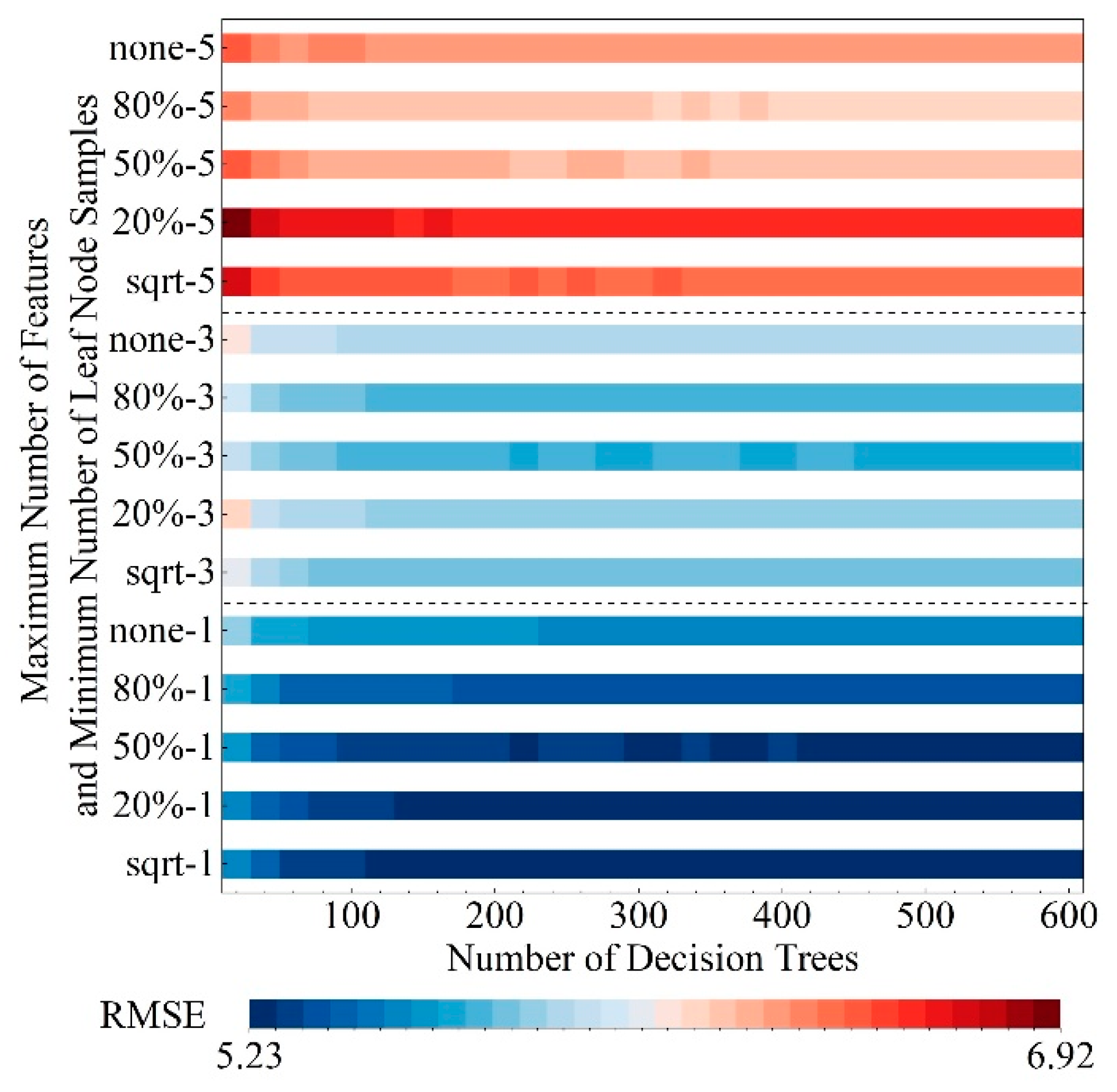
Hyperparameters such as the number of decision trees, minimum number of leaf node samples, and maximum number of features play pivotal roles in determining the model’s performance and generalization capacity. In this study, the hyperparameters include the number of trees ranging from 0 to 600 with a step of 20; the minimum number of samples required for splitting an internal node is set to 1, 3, or 5; and for selecting the best split, the maximum number of features considered is either the square root of the total, 20%, 50%, 80% of the total, or none (indicating all features). These hyperparameters were optimized using a 5-fold cross-validation and grid search method to identify the optimal configuration.
To assess the accuracy of the potential NPP model, evaluation metrics including root mean square error (RMSE), coefficient of determination (R2), and relative root mean square error (rRMSE) were utilized. The formula used for evaluation is:
O N P P m = 1 n × i = 1 n O N P P .
R M S E = 1 n i = 1 n O N P P P N P P 2 .
R 2 = 1 i = 1 n O N P P P N P P 2 i = 1 n O N P P O N P P m 2 .
r R M S E = R M S E O N P P m .
where ONPPm is the mean of the NPP observations, ONPP is the NPP observations, and PNPP is the predicted values of the potential NPP model.
The random forest regression model established in this study was implemented using the scikit-learn library in Python 3.11. This library supports feature importance calculation, hyperparameter tuning, cross-validation and accuracy computation.

3.3. Estimation of Grassland Carrying Capacity

This study utilized potential NPP as a basis, incorporating factors such as the aboveground and belowground biomass ratio of vegetation, optimal grassland utilization, grass palatability, accessibility, and livestock food consumption to estimate grassland carrying capacity.
Aboveground biomass (AGB) was estimated using potential NPP as shown in the following equation:
A G B = P N P P × T C M R 1 × ( 1 + R 2 ) .
The conversion ratio R1 between NPP and biomass has been estimated at 0.45 [45]. While this value is commonly used in studies, its applicability across different grassland types and geographic regions remains uncertain. The ratio R2, which denotes the conversion of below-ground biomass to above-ground biomass, varies depending on grassland type [45,46,47], as detailed in Table 4. TCM stands for the canopy multiplier, representing the proportion of NPP allocated to tree biomass [10]. In the Selinco Region, where tree survival is challenging, this value is set to 1.
Not all aboveground biomass is accessible to livestock. The available forage yield is influenced by several factors. The condition of grassland can improve with reasonable utilization but deteriorate with overgrazing. Maintaining the balance and stability of grassland ecosystems requires setting appropriate grazing utilization rates, though determining these rates remains contentious. In this study, we referenced “NY/T635-2015” to establish reasonable utilization rates for different grassland types. To account for poisonous and inedible grasses, we included the proportion of edible pasture to reflect their edibility. Considering the impact of elevation and slope on grassland carrying capacity, we also incorporated an accessibility index. By integrating these considerations, we calculated the available forage yield using the following formula:
A F Y = A G B × C 1 × C 2 × A C I .
A C I = 1 R S 100 ,   D E M < 5600 0 , D E M 5600 .
R S = 0.0093 × S 2 + 1.0409 × S , 0 S 60 100 , S > 60 .
where AFY is the available forage yield, C1 is the reasonable utilization rate of grassland (see Table 4 for details), and C2 is the proportion of edible pasture, taking the value of 80% [48]. The value of the proportion of edible pasture is an empirical value, and this study does not deny that the idealization of this value ignores the spatial heterogeneity of the edible nature of the real grassland. ACI is the accessibility index of grassland. When the elevation is greater than 5600 m, it is unsuitable for grazing [49]. RS is the reduction factor due to different slope steepness [10]—the larger the slope the lower the ACI—and when the slope is greater than 60°, the grassland is not accessible.
The final formula for estimating grassland carrying capacity is as follows:
C C = A F Y L P C × D A Y S .
In the formula, CC is grassland carrying capacity. LPC is the amount of pasture consumed by livestock per day. The value of LPC depends on the size and species of livestock and the quality of pasture. This study refers to “NY/T6352015” to select the standard hay consumed by the adult sheep weighing 45kg per day as the value of LPC, and the value is taken to be 1.8kg. DAYS is the number of grazing days per year, and the value was taken as 365.
The calculations of aboveground biomass, available forage yield and grassland carrying capacity were all conducted using Python 2.7 and Python 3.11.

4. Results

4.1. Potential NPP Simulation Accuracy

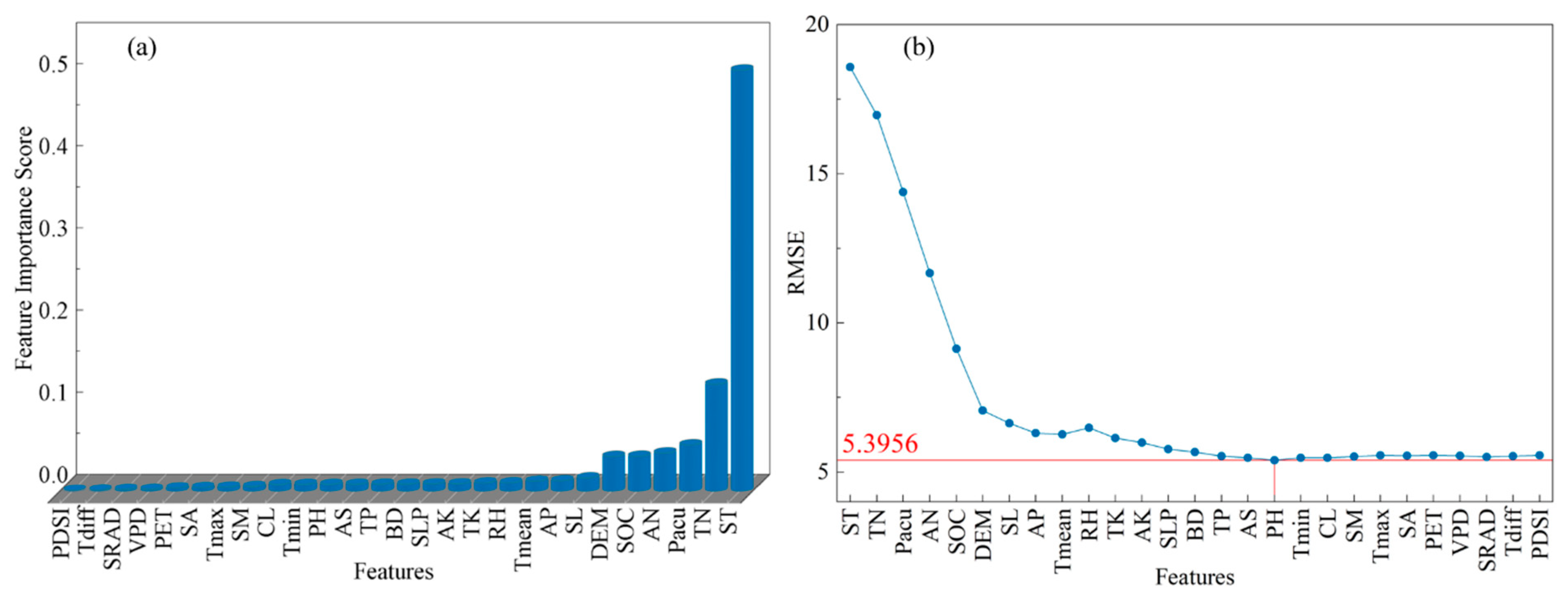
Based on the random forest feature importance scores and the forward feature selection algorithm, the original 27 input features for the random forest potential NPP model were screened. The 17 most important features, including soil temperature, mean annual temperature, cumulative annual precipitation, and mean annual relative humidity, were selected as the optimal input feature set for the model (Figure 3). Results from the cross-validation grid search (Figure 4) identified three critical hyperparameters, and their combination was used as the optimal hyperparameter set for the model. The results of hyperparameter selection are as follows: the number of decision trees is 540, the minimum number of leaf node samples is one, and the maximum number of features is the square root of the total.
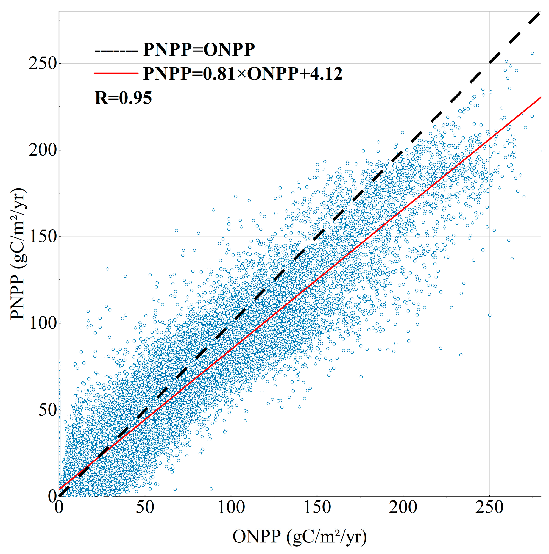
The performance of the model with this optimal feature set and hyperparameter set is shown in Table 5. The model demonstrates high accuracy. Additionally, a linear fit of the simulated potential NPP versus the observed potential NPP was conducted (Figure 5). The correlation coefficient and slope are close to 1, indicating that the model has a high fitting capability [30] and meets the requirements for spatiotemporal simulation of potential NPP effectively.

4.2. Spatial and Temporal Distribution of Grassland Carrying Capacity

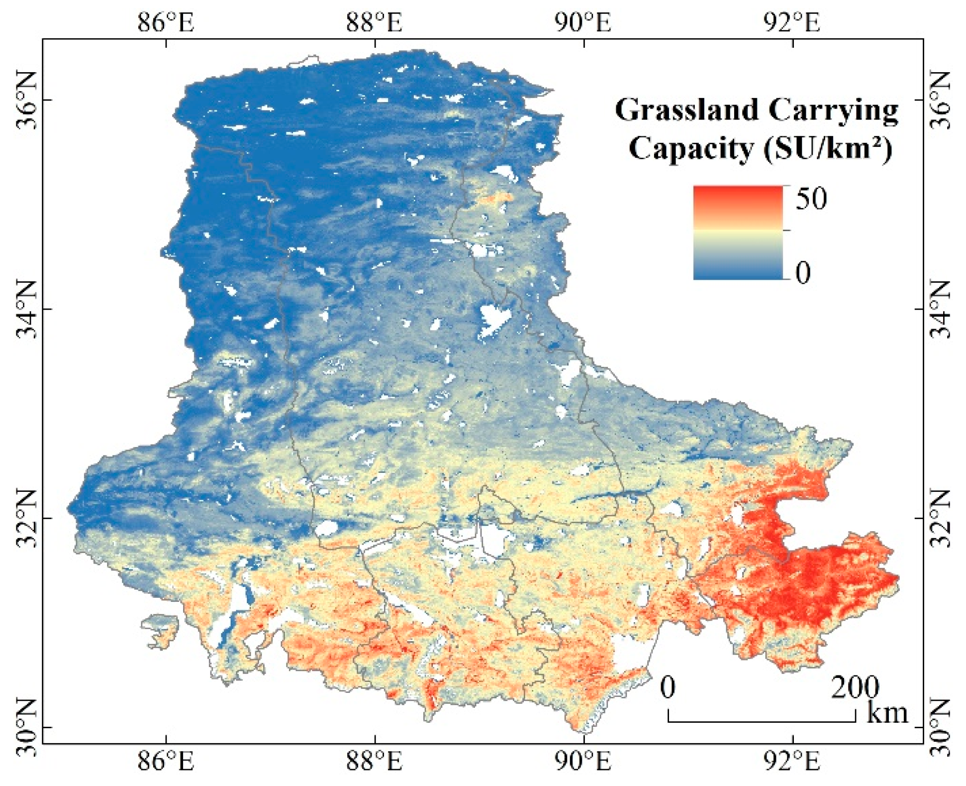
From 2001 to 2020, the average annual grassland carrying capacity in the Selinco Region ranged between 0 and 50 SU/km2 (Figure 6), with a mean of 9.44 SU/km2. Excluding forbidden grazing areas, the average increased to 10.84 SU/km2. The grassland carrying capacity exhibits significant spatial variations characterized by a gradual decrease from southeast to northwest. Specifically, the region is roughly divided into two parts by the 33° N latitude line, with 10 SU/km2 marking the boundary. South of the Tanggula Mountains and east of Selinco Lake, the grassland carrying capacity exceeds 10 SU/km2, encompassing most areas of Seni, southern Anduo, southern Bange, and some southeastern areas of Shenzha. Conversely, the area between the Kunlun Mountains and Hoh Xil Mountains exhibits extremely low grassland carrying capacity, less than 5 SU/km2, including northern Shuanghu, northern Nima, and parts of northern Anduo.
In terms of county administrative divisions (Figure 7), Nima and Shuanghu exhibit the lowest grassland carrying capacity, ranging between 5 and 10 SU/km2. Anduo ranges from 10 and 15 SU/km2, while Shenzha and Bange range between 15 and 20 SU/km2. Seni boasts the highest carrying capacity, exceeding 20 SU/km2, which is three to four times greater than that of Shuanghu.
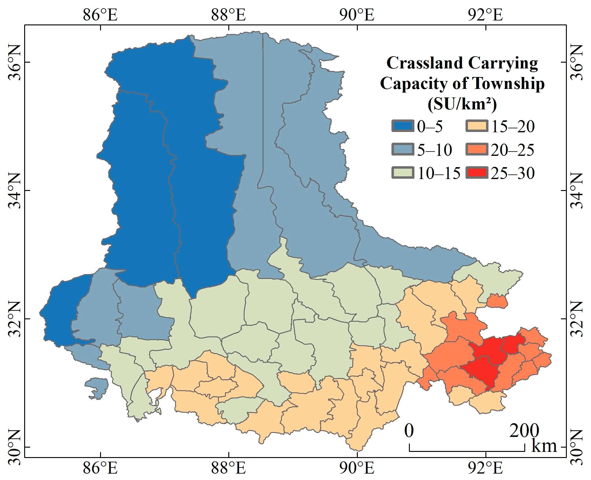
At the township level (Table 6 and Figure 8), townships with high grassland carrying capacity are predominantly concentrated in the southeastern region, with the highest capacity exceeding 25 SU/km2. Conversely, townships with lower capacity are mainly found in the northern and northwestern regions, some dropping below 5 SU/km2. The majority of townships, comprising 37 out of 59, exhibit a carrying capacity between 10 and 20 SU/km2. It is noteworthy that although fewer than one-sixth of the total townships, specifically nine, have a capacity below 10 SU/km2, these areas cover more than half of the entire study area. This underscores the significant spatial distribution and variation in grassland carrying capacity.
Figure 9 illustrates the annual changes in grassland carrying capacity in the Selinco Region from 2001 to 2020. Overall, the grassland carrying capacity fluctuates between 8.91 and 9.91 SU/km2. The lowest and highest years are observed in 2015 and 2016, respectively. This phenomenon may be related to the occurrence of the super El Niño event in 2015/2016, which significantly reduced precipitation in the Selinco Region. Compared to 2001, the grassland carrying capacity in 2020 increases by less than 0.01 SU/km2, representing a growth rate of 0.04%. Over a 5-year cycle, the grassland carrying capacity shows a pattern of increase, decrease, and subsequent increase. From 2001 to 2005, the carrying capacity remains relatively stable at a low level with an average of 9.34 SU/km2. Over the next 15 years, the carrying capacity starts to vary more significantly. It peaks at 9.60 SU/km2 from 2006 to 2010 and drops to its lowest point at 9.28 SU/km2 from 2011 to 2015. The average carrying capacity in the last 5 years is 9.52 SU/km2, showing significant improvement compared to 2001–2005, with an increase of 0.24 SU/km2 and a growth rate of 2.59%. The results indicate that climate changes in the Selinco Region contribute to the fluctuating grassland carrying capacity during 2001–2020. However, the increasing year-to-year variability highlights the need for flexible livestock management to prevent overgrazing during low-capacity periods, which could lead to an increased risk of grassland degradation. Additionally, slight increases in carrying capacity are observed in Seni, Anduo, Nima, and Shuanghu, while Bange and Shenzha show slight declines.

4.3. Spatial and Temporal Trends and Significance Tests for Grassland Carrying Capacity

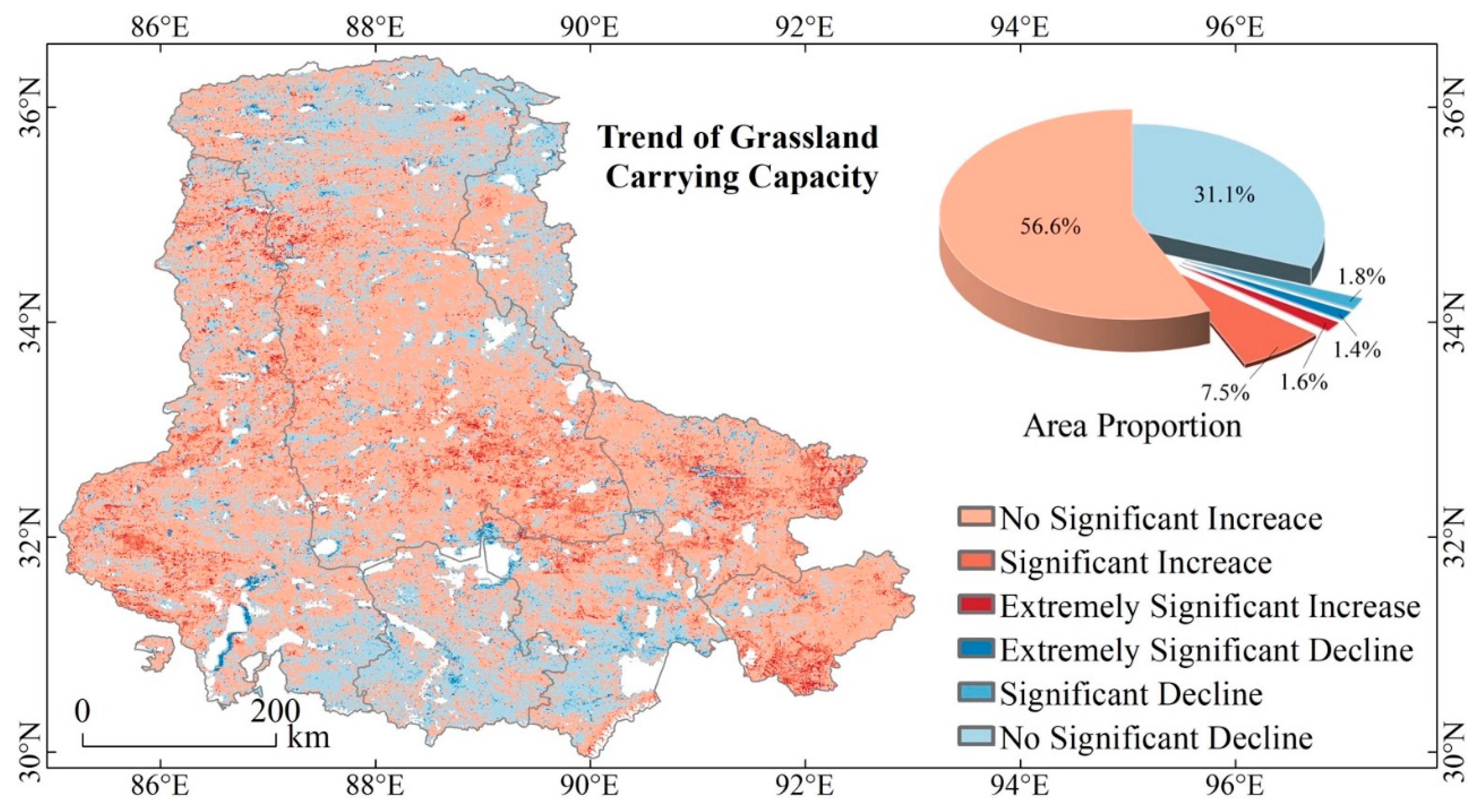
In this study, the combination of the Theil–Sen Median method and the Mann–Kendall test [50] was employed to analyze spatiotemporal variations in grassland carrying capacity. Based on identified trends and significance levels, changes were categorized into six classes (see Table 7 and Figure 10). The majority of the study area shows no significant increase or decline in grassland carrying capacity, accounting for 87.70% of the total. Areas with no significant decline are primarily concentrated within the region encompassed by Tangra Yumco Lake, Selinco Lake, Namtso Lake, and Nyainqntanglha Mountains, as well as the northern part of the Qiangtang National Nature Reserve. A significant or extremely significant increase is less prevalent, comprising less than 10% of the total and mainly scattered in southern Seni, Anduo, Shuanghu, as well as the western and northern parts of Nima. Areas exhibiting a significant or extremely significant decline are sporadic, making up less than 5% of the total. The ratio of areas showing an increase in grassland carrying capacity to those showing a decline is 1.91:1, highlighting a prevailing trend towards enhanced carrying capacity.

4.4. Grassland Carrying Capacity across Different Grassland Types and Terrain Conditions

Grasslands respond differently to climate across various types and topographic conditions [51,52]. To better understand grassland carrying capacity across different elevation zones and grassland types, this study conducted a detailed analysis.
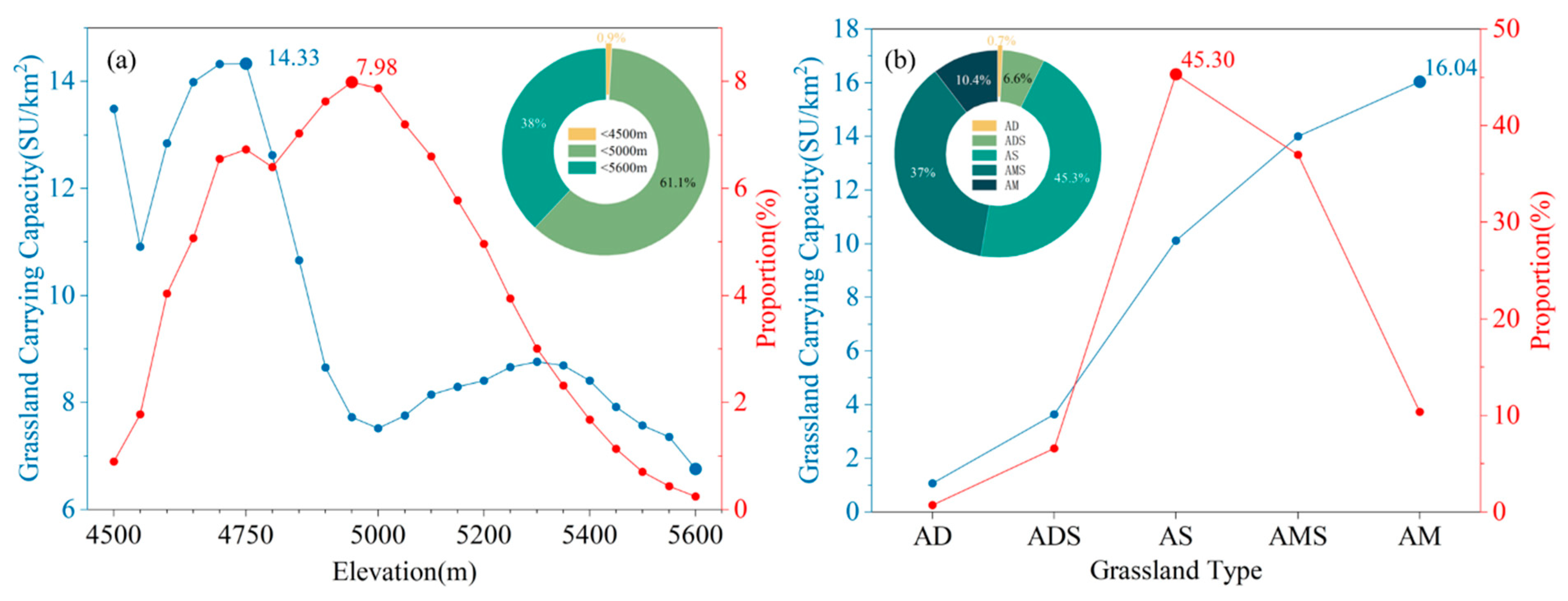
The variation in grassland carrying capacity with elevation in the study area can be divided into three main parts (Figure 11a):
  • Areas below 4500 m, which have high grassland carrying capacity but constitute less than 1% of the total area, limiting their representativeness.
  • Areas between 4500 and 5000 m, accounting for approximately 46% of the total area and about 61% of the overall carrying capacity. Within this range, carrying capacity increases rapidly to a peak of 14.33 SU/km2 at 4700–4750 m, then declines sharply to 7.52 SU/km2 at 4950–5000 m.
  • Areas above 5000 m, where the carrying capacity gradually increases and then decreases with elevation changes, generally remaining at a lower level.
In terms of grassland types (Figure 11b), the grassland carrying capacity per unit area increases sequentially from alpine desert, alpine desert steppe, alpine steppe, alpine meadow steppe to alpine meadow, with alpine meadow having more than 15 times the carrying capacity of alpine desert. Alpine steppe and alpine meadow steppe, due to their higher carrying capacity and larger areas, account for 45.30% and 37.01% of the total carrying capacity, respectively.
Overall, areas below 4750 m elevation, including alpine meadow and alpine meadow steppe, are more suitable for grazing. These areas, combined with those below 5000 m elevation, including alpine meadow, alpine meadow steppe and alpine steppe encompass the majority of the grassland carrying capacity in the study area and should be emphasized as primary grazing zones. This finding aligns with the high-altitude ecological relocation in Naqu in 2019: the harsh ecological conditions in high-altitude areas of northern Tibet result in extremely low grassland carrying capacity, making them unsuitable for both human and livestock habitation.

5. Discussions

5.1. The Feasibility and Limitations of Potential NPP Modeling and Grassland Carrying Capacity Estimation Method

In this study, accurate estimation of potential NPP is crucial for assessing grassland carrying capacity. Currently, there is no uniform, mature, and systematic method for estimating potential NPP on a large scale over a long time series. Estimation often relies on real NPP models, such as the improved light energy utilization model and the enhanced climate model [53,54,55,56]. This is because potential NPP represents vegetation growth under natural conditions, unaffected by human activities [57]. Unlike actual NPP, potential NPP simulation methods lack real reference and validation data, and the limited number of influencing factors and empirical parameters in the models may affect their generalizability.
In the study area, characterized by a cold climate and high altitude, the unique geographical environment complicates the relationship among environmental factors, making it challenging to apply existing models. To address this problem, our study employs advanced modeling techniques including banned grazing areas and random forest regression to estimate potential NPP. The feasibility of our approach is demonstrated through three key aspects: complex natural environment factors, random forest algorithm, and training sample quality and size.
Vegetation growth is influenced by a myriad of natural environmental factors, with complex interrelationships among these factors affecting vegetation [52,58,59,60,61,62]. In the study area, the key natural factors influencing vegetation growth and their interactions are not fully understood. To address this, we included 27 potential influencing factors related to climate, soil, and topography in our potential NPP model, aiming to capture the full extent of natural environmental impacts on vegetation growth.
Random forest is effective in handling complex, multimodal data with multiple features [63,64]. They effectively address issues such as overfitting and multicollinearity [65,66] and accurately model nonlinear and complex relationships between NPP and environmental factors [67]. By using feature importance and forward feature selection, we identified the most critical factors affecting vegetation growth in the study area, removed redundant and noisy data, and rigorously optimized model hyperparameters to construct the optimal potential NPP model.
The accuracy of the model is significantly influenced by the quality and quantity of training samples, often more so than the choice of the algorithm itself [68]. The relatively uniform distribution of forbidden grazing areas in the study area and the 11-year time span of our data enhance the representation of potential NPP changes in both spatial and temporal dimensions, thereby improving model accuracy.
Although this study considered numerous natural elements, it did not account for the impact of wildlife, rodents, and insect pests on grassland depletion due to a lack of reliable data on these factors [45,69,70]. This omission may lead to an underestimation of potential NPP. While soil and climate factors are key for potential NPP simulation in this study, there are limitations to the data used: soil physicochemical data were static, the resolution of soil temperature data was coarse, and the cumulative and lagged effects of climate on grass growth were not considered [60,71,72]. These factors introduce a degree of uncertainty into the potential NPP simulation.
In this study, we reviewed literature on grassland carrying capacity from various study areas over the past 20 years [10,11,69,73,74,75] and applied strict constraints based on “NY/T6352015” to estimate the grassland carrying capacity in the study area. Despite a comprehensive consideration of factors such as potential grassland distribution, aboveground biomass percentage, grass utilization, the proportion of palatable forage, slope, forest cover, and livestock feed demand, several limitations remain.
The quality of forage significantly affects grassland carrying capacity [76]. For instance, forage from artificial grasslands generally has higher nutritional value and palatability and is less prone to contamination by poisonous weeds.
Seasonal and grazing factors also play a crucial role. This study primarily considers total annual grass production, which is only one aspect of grassland carrying capacity. It does not account for the uneven seasonal distribution of pasture production [77] or the effects of nomadic and rotational grazing practices by herders. Additionally, the shortage of foraging during long non-growing seasons further limits the number of livestock that the grassland can support [11].

5.2. Interpretations of Grassland Carrying Capacity Estimation Results: Insights and Implications

We analyzed the spatial and temporal dynamics of grassland carrying capacity in the Selinco Region from 2001 to 2020. Our findings offer new insights into the historical and future grassland carrying capacity on the Tibetan Plateau. The results enhance our understanding of the spatial and temporal distribution of grassland carrying capacity across the Tibetan Plateau and lay a solid foundation for future grassland management and conservation. This understanding is crucial for achieving sustainable grassland utilization and regional development in the face of climate and environmental changes.
From 2001 to 2020, the grassland carrying capacity in the study area remained relatively stable, exhibiting a slow upward trend. This suggests that climate change has a beneficial effect on enhancing grassland carrying capacity, although the overall improvement is limited. This finding aligns with previous research on the entire Qinghai-Tibetan Plateau from 2001 to 2015 [11]. Despite this slight increase, grassland carrying capacity continues to be low, emphasizing the necessity of maintaining a balance between grasses and livestock. Effective management strategies must adapt to local conditions and account for the comprehensive impacts of climate, soil, and topography on different types of grasslands, as well as the interannual fluctuations in grassland carrying capacity. Tailored management can facilitate the recovery of degraded grasslands and mitigate the grass–livestock imbalance. Additionally, our study demonstrates that random forest regression models and multisource remote sensing are valuable tools for assessing grassland carrying capacity, providing a framework for similar assessments in other ecologically fragile regions. Moving forward, we will conduct further research on actual livestock carrying capacity, comparing it with grassland carrying capacity and offering more precise management recommendations based on the degree of grassland degradation.
Due to differences in natural environments such as climate and topography, vegetation growth exhibits spatial heterogeneity, which reduces the accuracy of livestock carrying capacity assessments [45]. Most studies on grassland carrying capacity on the Tibetan Plateau have focused on either the entire plateau or the source region of the Three Rivers [69,75,78], with no research specifically targeting the Selinco Region. Compared to the Tibetan Plateau as a whole or other regions [10,73,74,79], the harsh climatic environment of the Selinco Region results in much lower grassland carrying capacity, particularly in the Qiangtang National Nature Reserve in the northern part of the study area, where it is extremely low. Therefore, it is understandable that our study finds the grassland carrying capacity consistently remains at a low level.
In the study area, the overall spatial distribution trend of grassland carrying capacity is higher in the southeast and lower in the northwest, which corresponds with the distribution patterns of NDVI, EVI, and FVC [30,52,80]. These indicators are the same as the carrying capacity in that they both reflect vegetation growth conditions, confirming that the spatial distribution pattern of grassland carrying capacity estimated in this study is reasonable.
Extensive research indicates that climate change significantly impacts vegetation on the Tibetan Plateau [81,82,83], particularly through alterations in temperature and precipitation that directly influence grassland productivity [84]. A recent study suggests that the widespread greening in the Selinco Region may be linked to climatic warming and increased humidity [80]. However, the responses of grassland ecosystems to temperature and precipitation variations vary with geographical location. Rising temperatures can enhance evaporation and transpiration, thereby limiting soil moisture availability and suppressing the NPP of grassland [85], while increased precipitation can promote NPP [86]. High-latitude and high-altitude regions are more sensitive to rising temperatures, while arid areas are particularly vulnerable to changes in precipitation [87].
Based on the results from feature selection of the random forest model, Tmean and Pacu emerge as key factors influencing grassland carrying capacity. We consider these two variables alongside ST and TN, which ranked highest in importance, to analyze the spatiotemporal distribution of grassland carrying capacity. A comparative analysis of Figure 8 and Figure 12b,d reveals that grassland carrying capacity in the Selinco Region is primarily constrained by Pacu and TN, generally increasing with their rise. However, in certain regions, ST and Tmean emerge as dominant factors. Region I experiences higher Pacu than Region II but exhibits lower grassland carrying capacity, likely due to elevated ST and Tmean coupled with lower TN. This imbalance of high temperatures and low precipitation limits vegetation growth. Meanwhile, Region III displays a spatial distribution of carrying capacity that is high in the center and lower at the edges, aligning with temperature distributions. This pattern may be attributed to saturation in Pacu and TN, coupled with favorable thermal conditions that enhance grassland growth.
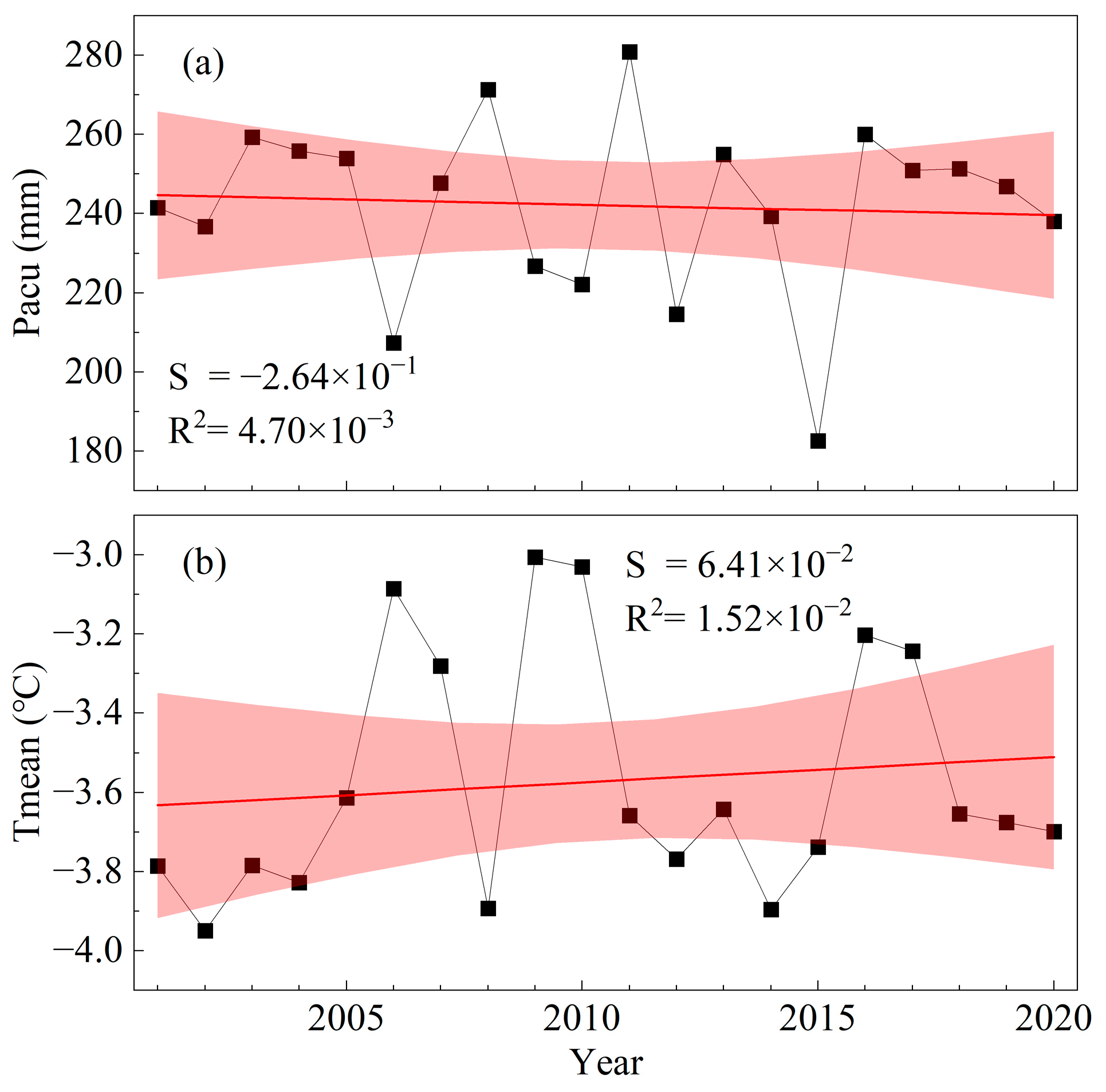
Figure 13 illustrates the changes in Tmean and Pacu over the past two decades in the Selinco Region: Tmean shows a slight increase, while Pacu shows a slight decline. When comparing this with Figure 8 and integrating our previous analyses, the slight increase in temperature may account for the insignificant decline in grassland carrying capacity in Regions I and II, while Region III shows an insignificant increase. Furthermore, the slight decline in precipitation may help explain the insignificant decline in grassland carrying capacity observed in the northeastern part of the Selinco Region.

6. Conclusions

This study introduces a framework for estimating grassland carrying capacity based on potential vegetation NPP and conducts a comprehensive analysis of the spatial and temporal dynamics of grassland carrying capacity in the Selinco Region on the Tibetan Plateau from 2001 to 2020. The findings provide crucial insights into the region’s ecological sustainability potential and serve as a reference for estimating grassland carrying capacity in similarly ecologically fragile areas. By isolating the direct impacts of human activities on vegetation, the study highlights the effects of climate change on grassland carrying capacity, offering valuable guidance for precise grassland management and conservation strategies in response to future climate variability.
The results reveal that the average grassland carrying capacity in the study area from 2001 to 2020 was 9.44 SU/km2, with notable spatial variation and a distribution pattern decreasing from southeast to northwest. Over the past two decades, the grassland carrying capacity has exhibited a slight upward trend that was not significant, and fluctuation tended to expand from year to year. Areas below 5000 m in altitude account for most of the grassland carrying capacity, with alpine meadow and alpine meadow steppe below 4750 m proving most suitable for grazing.
Despite the favorable impact of climate change on the grassland carrying capacity, it remains at a low level. Therefore, stringent control of local grazing intensity is essential. Additionally, the development of animal husbandry should be adjusted according to the spatial and temporal patterns of carrying capacity to better align with local conditions.
Author Contributions

Conceptualization, F.J. and Y.X.; Methodology, F.J., G.X. and Z.G.; Validation, F.J.; Formal analysis, F.J. and G.X.; Resources, F.J.; Data curation, F.J. and C.M.; Writing—original draft, F.J.; Writing—review & editing, F.J., G.X., X.Z. and H.Z.; Visualization, F.J. and H.H.; Supervision, F.J.; Project administration, Y.X.; Funding acquisition, Y.X. All authors have read and agreed to the published version of the manuscript.

Funding

We gratefully acknowledge the support provided by the Second Tibetan Plateau Scientific Expedition and Research Program (STEP) [2019QZKK0603], the National Key Research and Development Program of China [2018YFA0606404-03], and the Strategic Priority Research Program of the Chinese Academy of Sciences, Pan-Third Pole Environment Study for a Green Silk Road (Pan-TPE) [XDA2009000001].

Data Availability Statement

The data utilized in this study are detailed in the data section of the article.

Conflicts of Interest

The authors declare no conflicts of interest.

References

  1. Savage, J.; Woodcock, B.A.; Bullock, J.M.; Nowakowski, M.; Tallowin, J.R.B.; Pywell, R.F. Management to Support Multiple Ecosystem Services from Productive Grasslands. Sustainability 2021, 13, 6263. [Google Scholar] [CrossRef]
  2. Wang, Q.; Peng, X.; Watanabe, M.; Batkhishig, O.; Okadera, T.; Saito, Y. Carbon Budget in Permafrost and Non-Permafrost Regions and Its Controlling Factors in the Grassland Ecosystems of Mongolia. Glob. Ecol. Conserv. 2023, 41, e02373. [Google Scholar] [CrossRef]
  3. Ali, I.; Cawkwell, F.; Dwyer, E.; Barrett, B.; Green, S. Satellite Remote Sensing of Grasslands: From Observation to Management. J. Plant Ecol. 2016, 9, 649–671. [Google Scholar] [CrossRef]
  4. Herrero, M.; Havlík, P.; Valin, H.; Notenbaert, A.; Rufino, M.C.; Thornton, P.K.; Blümmel, M.; Weiss, F.; Grace, D.; Obersteiner, M. Biomass Use, Production, Feed Efficiencies, and Greenhouse Gas Emissions from Global Livestock Systems. Proc. Natl. Acad. Sci. USA 2013, 110, 20888–20893. [Google Scholar] [CrossRef] [PubMed]
  5. Li, H.; Song, W. Spatiotemporal Distribution and Influencing Factors of Ecosystem Vulnerability on Qinghai-Tibet Plateau. Int. J. Environ. Res. Public Health 2021, 18, 6508. [Google Scholar] [CrossRef]
  6. Li, M.; Zhang, X.; He, Y.; Niu, B.; Wu, J. Assessment of the Vulnerability of Alpine Grasslands on the Qinghai-Tibetan Plateau. PeerJ 2020, 8, e8513. [Google Scholar] [CrossRef]
  7. Zhu, Q.; Chen, H.; Peng, C.; Liu, J.; Piao, S.; He, J.-S.; Wang, S.; Zhao, X.; Zhang, J.; Fang, X.; et al. An Early Warning Signal for Grassland Degradation on the Qinghai-Tibetan Plateau. Nat. Commun. 2023, 14, 6406. [Google Scholar] [CrossRef]
  8. Harris, R.B. Rangeland Degradation on the Qinghai-Tibetan Plateau: A Review of the Evidence of Its Magnitude and Causes. J. Arid. Environ. 2010, 74, 1–12. [Google Scholar] [CrossRef]
  9. Sun, H.; Zheng, D.; Yao, T.; Zhang, Y. Protection and Construction of the National Ecological Security Shelter Zone on Tibetan Plateau. Acta Geogr. Sin. 2012, 67, 3–12. [Google Scholar]
  10. Wang, Q.; Okadera, T.; Nakayama, T.; Batkhishig, O.; Bayarsaikhan, U. Estimation of the Carrying Capacity and Relative Stocking Density of Mongolian Grasslands under Various Adaptation Scenarios. Sci. Total Environ. 2024, 913, 169772. [Google Scholar] [CrossRef]
  11. Piipponen, J.; Jalava, M.; de Leeuw, J.; Rizayeva, A.; Godde, C.; Cramer, G.; Herrero, M.; Kummu, M. Global Trends in Grassland Carrying Capacity and Relative Stocking Density of Livestock. Glob. Chang. Biol. 2022, 28, 3902–3919. [Google Scholar] [CrossRef] [PubMed]
  12. NY/T6352015; Calculation of Rangeland Carrying Capacity. Ministry of Agriculture of the People’s Republic of China: Beijing, China, 2015.
  13. Scarnecchia, D. Concepts of Carrying-Capacity and Substitution Ratios—A Systems Viewpoint. J. Range Manag. 1990, 43, 553–555. [Google Scholar] [CrossRef]
  14. Kooistra, L.; Berger, K.; Brede, B.; Graf, L.V.; Aasen, H.; Roujean, J.-L.; Machwitz, M.; Schlerf, M.; Atzberger, C.; Prikaziuk, E.; et al. Reviews and Syntheses: Remotely Sensed Optical Time Series for Monitoring Vegetation Productivity. Biogeosciences 2024, 21, 473–511. [Google Scholar] [CrossRef]
  15. Liu, H.; Zhang, A.; Zhao, Y.; Zhao, A.; Wang, D. Spatial Scale Transformation-Based Estimation Model for Fresh Grass Yield: A Case Study of the Xilingol Grassland, Inner Mongolia, China. Environ. Sci. Pollut. Res. 2023, 30, 1085–1095. [Google Scholar] [CrossRef]
  16. Qian, S.; Wang, L.Y.; Gong, X.F. Climate Change and Its Effects on Grassland Productivity and Carrying Capacity of Livestock in the Main Grasslands of China. Rangel. J. 2012, 34, 341–347. [Google Scholar] [CrossRef]
  17. Cao, D.; Zhang, J.; Xun, L.; Yang, S.; Wang, J.; Yao, F. Spatiotemporal Variations of Global Terrestrial Vegetation Climate Potential Productivity under Climate Change. Sci. Total Environ. 2021, 770, 145320. [Google Scholar] [CrossRef]
  18. Jiang, C.; Ryu, Y. Multi-Scale Evaluation of Global Gross Primary Productivity and Evapotranspiration Products Derived from Breathing Earth System Simulator (BESS). Remote Sens. Environ. 2016, 186, 528–547. [Google Scholar] [CrossRef]
  19. Fang, J.; Yu, G.; Liu, L.; Hu, S.; Chapin, F.S. Climate Change, Human Impacts, and Carbon Sequestration in China INTRODUCTION. Proc. Natl. Acad. Sci. USA 2018, 115, 4015–4020. [Google Scholar] [CrossRef]
  20. Chen, X.; Su, Z.; Ma, Y.; Liu, S.; Yu, Q.; Xu, Z. Development of a 10-Year (2001–2010) 0.1° Data Set of Land-Surface Energy Balance for Mainland China. Atmos. Chem. Phys. 2014, 14, 13097–13117. [Google Scholar] [CrossRef]
  21. Chen, H.; Zhu, Q.; Peng, C.; Wu, N.; Wang, Y.; Fang, X.; Gao, Y.; Zhu, D.; Yang, G.; Tian, J.; et al. The Impacts of Climate Change and Human Activities on Biogeochemical Cycles on the Qinghai-Tibetan Plateau. Glob. Chang. Biol. 2013, 19, 2940–2955. [Google Scholar] [CrossRef]
  22. Yu, H.; Ding, Q.; Meng, B.; Lv, Y.; Liu, C.; Zhang, X.; Sun, Y.; Li, M.; Yi, S. The Relative Contributions of Climate and Grazing on the Dynamics of Grassland NPP and PUE on the Qinghai-Tibet Plateau. Remote Sens. 2021, 13, 3424. [Google Scholar] [CrossRef]
  23. Zhang, S.; Hao, X.; Zhao, Z.; Zhang, J.; Fan, X.; Li, X. Natural Vegetation Succession Under Climate Change and the Combined Effects on Net Primary Productivity. Earth Future 2023, 11, e2023EF003903. [Google Scholar] [CrossRef]
  24. Chiarucci, A.; Araújo, M.B.; Decocq, G.; Beierkuhnlein, C.; Fernández-Palacios, J.M. The Concept of Potential Natural Vegetation: An Epitaph?: The Concept of Potential Natural Vegetation. J. Veg. Sci. 2010, 21, 1172–1178. [Google Scholar] [CrossRef]
  25. Qin, Y.; Liu, J.; Shi, W.; Tao, F.; Yan, H. Spatial-Temporal Changes of Cropland and Climate Potential Productivity in Northern China during 1990–2010. Food Sec. 2013, 5, 499–512. [Google Scholar] [CrossRef]
  26. Liu, Y.; Wang, Q.; Zhang, Z.; Tong, L.; Wang, Z.; Li, J. Grassland Dynamics in Responses to Climate Variation and Human Activities in China from 2000 to 2013. Sci. Total Environ. 2019, 690, 27–39. [Google Scholar] [CrossRef]
  27. Cao, D.; Zhang, J.; Zhang, T.; Yao, F.; Ji, R.; Zi, S.; Li, H.; Cheng, Q. Spatiotemporal Variations and Driving Factors of Global Terrestrial Vegetation Productivity Gap under the Changing of Climate, CO2, Landcover and N Deposition. Sci. Total Environ. 2023, 880, 162753. [Google Scholar] [CrossRef]
  28. Xi, G.; Ma, C.; Xie, Y.; Guo, Z.; Bao, T.; Zhang, X.; Liu, Y.; Wang, H. Spatialization Method of Monitoring Grazing Intensity: A Case-study of the Tibet Selinco Basin, Qinghai-Tibet Plateau. Land Degrad. Dev. 2023, 34, 1311–1322. [Google Scholar] [CrossRef]
  29. Ma, C.; Xie, Y.; Duan, S.-B.; Qin, W.; Guo, Z.; Xi, G.; Zhang, X.; Bie, Q.; Duan, H.; He, L. Characterization of Spatio-Temporal Patterns of Grassland Utilization Intensity in the Selinco Watershed of the Qinghai-Tibetan Plateau from 2001 to 2019 Based on Multisource Remote Sensing and Artificial Intelligence Algorithms. GIScience Remote Sens. 2022, 59, 2217–2246. [Google Scholar] [CrossRef]
  30. Ma, C.; Xie, Y.; Duan, H.; Wang, X.; Bie, Q.; Guo, Z.; He, L.; Qin, W. Spatial Quantification Method of Grassland Utilization Intensity on the Qinghai-Tibetan Plateau: A Case Study on the Selinco Basin. J. Environ. Manag. 2022, 302, 114073. [Google Scholar] [CrossRef]
  31. Zhou, J.; Lu, T. Relative Contributions of Climate Change and Human Activities on Vegetation Productivity Variation in National Nature Reserves on the Qinghai-Tibetan Plateau. Remote Sens. 2022, 14, 4626. [Google Scholar] [CrossRef]
  32. De Leeuw, J.; Rizayeva, A.; Namazov, E.; Bayramov, E.; Marshall, M.T.; Etzold, J.; Neudert, R. Application of the MODIS MOD 17 Net Primary Production Product in Grassland Carrying Capacity Assessment. Int. J. Appl. Earth Obs. Geoinf. 2019, 78, 66–76. [Google Scholar] [CrossRef]
  33. Ge, W.; Deng, L.; Wang, F.; Han, J. Quantifying the Contributions of Human Activities and Climate Change to Vegetation Net Primary Productivity Dynamics in China from 2001 to 2016. Sci. Total Environ. 2021, 773, 145648. [Google Scholar] [CrossRef] [PubMed]
  34. Zhao, J.; Ji, G.; Tian, Y.; Chen, Y.; Wang, Z. Environmental Vulnerability Assessment for Mainland China Based on Entropy Method. Ecol. Indic. 2018, 91, 410–422. [Google Scholar] [CrossRef]
  35. Xu, M.; Zhang, T.; Zhang, Y.; Chen, N.; Zhu, J.; He, Y.; Zhao, T.; Yu, G. Drought Limits Alpine Meadow Productivity in Northern Tibet. Agric. For. Meteorol. 2021, 303, 108371. [Google Scholar] [CrossRef]
  36. Abatzoglou, J.T. Development of Gridded Surface Meteorological Data for Ecological Applications and Modelling. Int. J. Climatol. 2013, 33, 121–131. [Google Scholar] [CrossRef]
  37. Cantón, Y.; Del Barrio, G.; Solé-Benet, A.; Lázaro, R. Topographic Controls on the Spatial Distribution of Ground Cover in the Tabemas Badlands of SE Spain. Catena 2004, 55, 341–365. [Google Scholar] [CrossRef]
  38. Luo, Y.; Peng, Q.; Li, K.; Gong, Y.; Liu, Y.; Han, W. Patterns of Nitrogen and Phosphorus Stoichiometry among Leaf, Stem and Root of Desert Plants and Responses to Climate and Soil Factors in Xinjiang, China. Catena 2021, 199, 105100. [Google Scholar] [CrossRef]
  39. Fayiah, M.; Dong, S.; Li, Y.; Xu, Y.; Gao, X.; Li, S.; Shen, H.; Xiao, J.; Yang, Y.; Wessell, K. The Relationships between Plant Diversity, Plant Cover, Plant Biomass and Soil Fertility Vary with Grassland Type on Qinghai-Tibetan Plateau. Agric. Ecosyst. Environ. 2019, 286, 106659. [Google Scholar] [CrossRef]
  40. Li, C.; De Jong, R.; Schmid, B.; Wulf, H.; Schaepman, M.E. Spatial Variation of Human Influences on Grassland Biomass on the Qinghai-Tibetan Plateau. Sci. Total Environ. 2019, 665, 678–689. [Google Scholar] [CrossRef]
  41. Wang, Z.; Luo, T.; Li, R.; Tang, Y.; Du, M. Causes for the Unimodal Pattern of Biomass and Productivity in Alpine Grasslands along a Large Altitudinal Gradient in Semi-arid Regions. J Veg. Sci. 2013, 24, 189–201. [Google Scholar] [CrossRef]
  42. Liu, J.; Kuang, W.; Zhang, Z.; Xu, X.; Qin, Y.; Ning, J.; Zhou, W.; Zhang, S.; Li, R.; Yan, C.; et al. Spatiotemporal Characteristics, Patterns, and Causes of Land-Use Changes in China since the Late 1980s. J. Geogr. Sci. 2014, 24, 195–210. [Google Scholar] [CrossRef]
  43. Ning, J.; Liu, J.; Kuang, W.; Xu, X.; Zhang, S.; Yan, C.; Li, R.; Wu, S.; Hu, Y.; Du, G.; et al. Spatiotemporal Patterns and Characteristics of Land-Use Change in China during 2010–2015. J. Geogr. Sci. 2018, 28, 547–562. [Google Scholar] [CrossRef]
  44. Su, D. The Compilation and Study of the Grassland Resource Map of China on the Scale of 1:1000000. J. Nat. Resour. 1996, 11, 75–83. [Google Scholar]
  45. Cai, Z.; Song, P.; Wang, J.; Jiang, F.; Liang, C.; Zhang, J.; Gao, H.; Zhang, T. Grazing Pressure Index Considering Both Wildlife and Livestock in Three-River Headwaters, Qinghai-Tibetan Plateau. Ecol. Indic. 2022, 143, 109338. [Google Scholar] [CrossRef]
  46. Piao, S.; Fang, J.; He, J.; Xiao, Y. Spatial Distrution of Grassland Biomass in China. Chin. J. Plant Ecol. 2004, 28, 491–498. [Google Scholar]
  47. Chen, S.; Wang, S.; Zhou, Y. Estimation of Chinese grassland productivity using remote sensing. Trans. Chin. Soc. Agric. Eng. 2008, 24, 208–212. [Google Scholar]
  48. Zhang, H.; Fan, J.; Wang, J.; Cao, W.; Harris, W. Spatial and Temporal Variability of Grassland Yield and Its Response to Climate Change and Anthropogenic Activities on the Tibetan Plateau from 1988 to 2013. Ecol. Indic. 2018, 95, 141–151. [Google Scholar] [CrossRef]
  49. Zhou, J.; Niu, J.; Wu, N.; Lu, T. Annual High-Resolution Grazing Intensity Maps on the Qinghai-Tibet Plateau from 1990 to 2020. Earth Syst. Sci. Data 2023, 1–21. [Google Scholar] [CrossRef]
  50. Jiang, W.; Yuan, L.; Wang, W.; Cao, R.; Zhang, Y.; Shen, W. Spatio-Temporal Analysis of Vegetation Variation in the Yellow River Basin. Ecol. Indic. 2015, 51, 117–126. [Google Scholar] [CrossRef]
  51. Guo, D.; Song, X.; Hu, R.; Cai, S.; Zhu, X.; Hao, Y. Grassland Type-Dependent Spatiotemporal Characteristics of Productivity in Inner Mongolia and Its Response to Climate Factors. Sci. Total Environ. 2021, 775, 145644. [Google Scholar] [CrossRef]
  52. Huang, H.; Xi, G.; Ji, F.; Liu, Y.; Wang, H.; Xie, Y. Spatial and Temporal Variation in Vegetation Cover and Its Response to Topography in the Selinco Region of the Qinghai-Tibet Plateau. Remote Sens. 2023, 15, 4101. [Google Scholar] [CrossRef]
  53. Xu, B.; Feng, Z.; Chen, Y.; Zhou, Y.; Shao, Y.; Wang, Z. Assessing the Distribution and Driving Effects of Net Primary Productivity along an Elevation Gradient in Subtropical Regions of China. Forests 2024, 15, 340. [Google Scholar] [CrossRef]
  54. Liu, Y.; Zhang, Z.; Tong, L.; Khalifa, M.; Wang, Q.; Gang, C.; Wang, Z.; Li, J.; Sun, Z. Assessing the Effects of Climate Variation and Human Activities on Grassland Degradation and Restoration across the Globe. Ecol. Indic. 2019, 106, 105504. [Google Scholar] [CrossRef]
  55. Mu, S.; Zhou, S.; Chen, Y.; Li, J.; Ju, W.; Odeh, I.O.A. Assessing the Impact of Restoration-Induced Land Conversion and Management Alternatives on Net Primary Productivity in Inner Mongolian Grassland, China. Glob. Planet. Chang. 2013, 108, 29–41. [Google Scholar] [CrossRef]
  56. Chen, T.; Bao, A.; Jiapaer, G.; Guo, H.; Zheng, G.; Jiang, L.; Chang, C.; Tuerhanjiang, L. Disentangling the Relative Impacts of Climate Change and Human Activities on Arid and Semiarid Grasslands in Central Asia during 1982-2015. Sci. Total Environ. 2019, 653, 1311–1325. [Google Scholar] [CrossRef]
  57. Yuan, Q.; Wu, S.; Dai, E.; Zhao, D.; Ren, P.; Zhang, X. NPP Vulnerability of the Potential Vegetation of China to Climate Change in the Past and Future. J. Geogr. Sci. 2017, 27, 131–142. [Google Scholar] [CrossRef]
  58. Wang, Y.; Lv, W.; Xue, K.; Wang, S.; Zhang, L.; Hu, R.; Zeng, H.; Xu, X.; Li, Y.; Jiang, L.; et al. Grassland Changes and Adaptive Management on the Qinghai-Tibetan Plateau. Nat. Rev. Earth Environ. 2022, 3, 668–683. [Google Scholar] [CrossRef]
  59. Huang, K.; Zhang, Y.; Zhu, J.; Liu, Y.; Zu, J.; Zhang, J. The Influences of Climate Change and Human Activities on Vegetation Dynamics in the Qinghai-Tibet Plateau. Remote Sens. 2016, 8, 876. [Google Scholar] [CrossRef]
  60. Zhang, Q.; Kong, D.; Shi, P.; Singh, V.P.; Sun, P. Vegetation Phenology on the Qinghai-Tibetan Plateau and Its Response to Climate Change (1982–2013). Agric. For. Meteorol. 2018, 248, 408–417. [Google Scholar] [CrossRef]
  61. Kaisermann, A.; de Vries, F.T.; Griffiths, R.I.; Bardgett, R.D. Legacy Effects of Drought on Plant-Soil Feedbacks and Plant-Plant Interactions. New Phytol. 2017, 215, 1413–1424. [Google Scholar] [CrossRef]
  62. Sun, H.; Chen, Y.; Xiong, J.; Ye, C.; Yong, Z.; Wang, Y.; He, D.; Xu, S. Relationships between Climate Change, Phenology, Edaphic Factors, and Net Primary Productivity across the Tibetan Plateau. Int. J. Appl. Earth Obs. Geoinf. 2022, 107, 102708. [Google Scholar] [CrossRef]
  63. Loozen, Y.; Rebel, K.T.; de Jong, S.M.; Lu, M.; Ollinger, S.V.; Wassen, M.J.; Karssenberg, D. Mapping Canopy Nitrogen in European Forests Using Remote Sensing and Environmental Variables with the Random Forests Method. Remote Sens. Environ. 2020, 247, 111933. [Google Scholar] [CrossRef]
  64. Moreno-Martínez, Á.; Camps-Valls, G.; Kattge, J.; Robinson, N.; Reichstein, M.; van Bodegom, P.; Kramer, K.; Cornelissen, J.H.C.; Reich, P.; Bahn, M.; et al. A Methodology to Derive Global Maps of Leaf Traits Using Remote Sensing and Climate Data. Remote Sens. Environn. 2018, 218, 69–88. [Google Scholar] [CrossRef]
  65. Xue, S.; Ma, B.; Wang, C.; Li, Z. Identifying Key Landscape Pattern Indices Influencing the NPP: A Case Study of the Upper and Middle Reaches of the Yellow River. Ecol. Modell. 2023, 484, 110457. [Google Scholar] [CrossRef]
  66. Smith, W.K.; Dannenberg, M.P.; Yan, D.; Herrmann, S.; Barnes, M.L.; Barron-Gafford, G.A.; Biederman, J.A.; Ferrenberg, S.; Fox, A.M.; Hudson, A.; et al. Remote Sensing of Dryland Ecosystem Structure and Function: Progress, Challenges, and Opportunities. Remote Sens. Environ. 2019, 233, 111401. [Google Scholar] [CrossRef]
  67. Zhou, T.; Hou, Y.; Yang, Z.; Laffitte, B.; Luo, K.; Luo, X.; Liao, D.; Tang, X. Reducing Spatial Resolution Increased Net Primary Productivity Prediction of Terrestrial Ecosystems: A Random Forest Approach. Sci. Total Environ. 2023, 897, 165134. [Google Scholar] [CrossRef]
  68. Millard, K.; Richardson, M. On the Importance of Training Data Sample Selection in Random Forest Image Classification: A Case Study in Peatland Ecosystem Mapping. Remote Sens. 2015, 7, 8489–8515. [Google Scholar] [CrossRef]
  69. Yu, H.; Liu, B.; Wang, G.; Zhang, T.; Yang, Y.; Lu, Y.; Xu, Y.; Huang, M.; Yang, Y.; Zhang, L. Grass-Livestock Balance Based Grassland Ecological Carrying Capability and Sustainable Strategy in the Yellow River Source National Park, Tibet Plateau, China. J. Mt. Sci. 2021, 18, 2201–2211. [Google Scholar] [CrossRef]
  70. Ren, Y.; Zhu, Y.; Baldan, D.; Fu, M.; Wang, B.; Li, J.; Chen, A. Optimizing Livestock Carrying Capacity for Wild Ungulate-Livestock Coexistence in a Qinghai-Tibet Plateau Grassland. Sci. Rep. 2021, 11, 3635. [Google Scholar] [CrossRef]
  71. Ding, Y.; Li, Z.; Peng, S. Global Analysis of Time-Lag and -Accumulation Effects of Climate on Vegetation Growth. Int. J. Appl. Earth Obs. Geoinf. 2020, 92, 102179. [Google Scholar] [CrossRef]
  72. Wei, X.; He, W.; Zhou, Y.; Ju, W.; Xiao, J.; Li, X.; Liu, Y.; Xu, S.; Bi, W.; Zhang, X.; et al. Global Assessment of Lagged and Cumulative Effects of Drought on Grassland Gross Primary Production. Ecol. Indic. 2022, 136, 108646. [Google Scholar] [CrossRef]
  73. Umuhoza, J.; Jiapaer, G.; Yin, H.; Mind’je, R.; Gasirabo, A.; Nzabarinda, V.; Umwali, E.D. The Analysis of Grassland Carrying Capacity and Its Impact Factors in Typical Mountain Areas in Central Asia—A Case of Kyrgyzstan and Tajikistan. Ecol. Indic. 2021, 131, 108129. [Google Scholar] [CrossRef]
  74. Guo, C.; Song, S.; Zhao, D.; Luo, S.; Yang, L.; Xie, G. Quantifying the Ecological Carrying Capacity of Grasslands in Inner Mongolia. PLoS ONE 2023, 18, e0291381. [Google Scholar] [CrossRef] [PubMed]
  75. Yang, Y.; Zhao, D.; Chen, H. Full Title: Quantifying the Ecological Carrying Capacity of Alpine Grasslands on the Qinghai-Tibet Plateau. Ecol. Indic. 2022, 136, 108634. [Google Scholar] [CrossRef]
  76. Ren, H.; Han, G.; Schönbach, P.; Gierus, M.; Taube, F. Forage Nutritional Characteristics and Yield Dynamics in a Grazed Semiarid Steppe Ecosystem of Inner Mongolia, China. Ecol. Indic. 2016, 60, 460–469. [Google Scholar] [CrossRef]
  77. Yu, H.; Xu, J.; Okuto, E.; Luedeling, E. Seasonal Response of Grasslands to Climate Change on the Tibetan Plateau. PLoS ONE 2012, 7, e49230. [Google Scholar] [CrossRef]
  78. Fang, Y.; Zhu, F.; Yi, S.; Qiu, X.; Ding, Y. Ecological Carrying Capacity of Alpine Grassland in the Qinghai-Tibet Plateau Based on the Structural Dynamics Method. Environ. Dev. Sustain. 2021, 23, 12550–12578. [Google Scholar] [CrossRef]
  79. Zhang, Y.J.; Zhang, X.Q.; Wang, X.Y.; Liu, N.; Kan, H.M. Establishing the Carrying Capacity of the Grasslands of China: A Review. Rangel. J. 2014, 36, 1–9. [Google Scholar] [CrossRef]
  80. Liu, Y.; Xie, Y.; Guo, Z.; Xi, G. Effects of Climate Variability and Human Activities on Vegetation Dynamics across the Qinghai–Tibet Plateau from 1982 to 2020. Remote Sens. 2023, 15, 4988. [Google Scholar] [CrossRef]
  81. Peng, S.; Piao, S.; Ciais, P.; Myneni, R.B.; Chen, A.; Chevallier, F.; Dolman, A.J.; Janssens, I.A.; Peñuelas, J.; Zhang, G.; et al. Asymmetric Effects of Daytime and Night-Time Warming on Northern Hemisphere Vegetation. Nature 2013, 501, 88–92. [Google Scholar] [CrossRef]
  82. Li, M.; Zhang, X.; Wu, J.; Ding, Q.; Niu, B.; He, Y. Declining Human Activity Intensity on Alpine Grasslands of the Tibetan Plateau. J. Environ. Manag. 2021, 296, 113198. [Google Scholar] [CrossRef]
  83. Yao, T.; Thompson, L.; Yang, W.; Yu, W.; Gao, Y.; Guo, X.; Yang, X.; Duan, K.; Zhao, H.; Xu, B.; et al. Different Glacier Status with Atmospheric Circulations in Tibetan Plateau and Surroundings. Nat. Clim. Chang. 2012, 2, 663–667. [Google Scholar] [CrossRef]
  84. Li, X.; Long, D.; Scanlon, B.R.; Mann, M.E.; Li, X.; Tian, F.; Sun, Z.; Wang, G. Climate Change Threatens Terrestrial Water Storage over the Tibetan Plateau. Nat. Clim. Chang. 2022, 12, 801–807. [Google Scholar] [CrossRef]
  85. Zhao, M.; Running, S.W. Drought-Induced Reduction in Global Terrestrial Net Primary Production from 2000 Through 2009. Science 2010, 329, 940–943. [Google Scholar] [CrossRef]
  86. Sun, C.; Zhong, X.; Chen, C.; Gu, T.; Chen, W. Evaluating the Grassland Net Primary Productivity of Southern China from 2000 to 2011 Using a New Climate Productivity Model. J. Integr. Agric. 2016, 15, 1638–1644. [Google Scholar] [CrossRef]
  87. Cong, N.; Shen, M.; Yang, W.; Yang, Z.; Zhang, G.; Piao, S. Varying Responses of Vegetation Activity to Climate Changes on the Tibetan Plateau Grassland. Int. J. Biometeorol. 2017, 61, 1433–1444. [Google Scholar] [CrossRef]
Figure 1. Overview of the study area. (a) Study area location and land cover types; (b) mean annual temperature; (c) annual precipitation; (d) elevation. The land cover data processing is detailed in Section 2.2.5 and Section 3.1. Banned grazing area data are sourced from local government departments, as detailed in Section 2.2.1. Temperature and precipitation data sources are detailed in Section 2.2.2. Elevation data sources are detailed in Section 2.2.3.
Remotesensing 16 03790 g001
Figure 2. Overall research process. It shows the overall process of data collection, processing, and spatiotemporal analysis. The flowchart outlines the steps of transforming raw data into analytical results, aiding in understanding the comprehensive methods and steps of data analysis.
Remotesensing 16 03790 g002
Figure 3. Results of the random forest feature importance scores (a) and the forward feature selection (b). The results of feature selection include the following variables: ST, TN, Pacu, AN, SOC, DEM, SL, AP, Tmean, RH, TK, AK, SLP, BD, TP, AS, and PH.
Remotesensing 16 03790 g003
Figure 4. Hyperparameter selection based on 5-fold cross validation and grid search. The selection results: the number of decision trees is 540, minimum number of leaf node samples is 1, and maximum number of features is sqrt.
Remotesensing 16 03790 g004
Figure 5. The fit performance of potential NPP model (2020 as an example).
Remotesensing 16 03790 g005
Figure 6. Spatial distribution pattern of grassland carrying capacity in the Selinco Region from 2001 to 2020. This figure is generated by overlaying the annual grassland carrying capacity over the 20-year period and calculating the mean using cell statistics (Mean Value Composites).
Remotesensing 16 03790 g006
Figure 7. Spatial distribution pattern of grassland carrying capacity at the county level.
Remotesensing 16 03790 g007
Figure 8. Spatial distribution pattern of grassland carrying capacity at the township level.
Remotesensing 16 03790 g008
Figure 9. Annual grassland carrying capacity statistics of the Selinco Region (a), Seni (b), Bange (c), Shenzha (d), Anduo (e), Nima (f) and Shuanghu (g).
Remotesensing 16 03790 g009
Figure 10. Spatial distribution pattern of interannual trends.
Remotesensing 16 03790 g010
Figure 11. Statistics of grassland carrying capacity across different elevation zones (a) and grassland types (b).
Remotesensing 16 03790 g011
Figure 12. Spatial distribution pattern of ST (a), TN (b), Tmean (c), and Pacu (d) at the township level. Region I−III are the three typical zones used for the discussion.
Remotesensing 16 03790 g012
Figure 13. Interannual variation in Tmean (a) and Pacu (b) in the Selinco Region from 2001 to 2020.
Remotesensing 16 03790 g013
Table 1. Resolution, time range and sources of data used in this study.
DataResolutionTime RangeSource
NPP500 m2001–2020https://developers.google.cn/earth-engine/datasets, accessed on 15 February 2024
Temperature1000 m2001–2020http://www.geodata.cn, accessed on 20 February 2024
Precipitation
Relative humidity
Potential evapotranspiration
Solar radiation4000 m2001–2020https://developers.google.cn/earth-engine/datasets, accessed on 20 February 2024
Palmer drought severity index
Vapor pressure deficit
Terrain30 mN/Ahttps://developers.google.cn/earth-engine/datasets, accessed on 20 February 2024
Soil physicochemical properties1000 mTwo periods: 1980s and 2010–2018http://www.geodata.cn, accessed on 25 February 2024; http://globalchange.bnu.edu.cn/research/data, accessed on 24 February 2024
Soil temperature and soil moisture0.1° × 0.1°2001–2020https://developers.google.cn/earth-engine/datasets, accessed on 20 February 2024
Land use1000 mFive periods: 2000, 2005, 2010, 2015 and 2020http://www.resdc.cn/DOI, accessed on 22 February 2023
Banned grazing areaN/A2011–2020local government departments
Table 2. Grassland classification indicators.
Grassland TypeMoisture StatusIvanov’s Wetness (K)
DesertExtremely arid<0.20
Desert steppeArid0.20~0.30
SteppeSemi-arid0.30~0.60
Meadow steppeSemi-humid0.60~1.00
MeadowHumid>1.00
Table 3. Input features and abbreviation.
FeatureAbbreviationFeatureAbbreviation
Mean annual temperatureTmeanAvailable nitrogenAN
Mean annual maximum temperatureTmaxAvailable phosphorusAP
Mean annual minimum temperatureTminTotal potassiumTK
Mean annual temperature differenceTdiffTotal nitrogenTN
Cumulative annual precipitationPacuTotal phosphorusTP
Mean annual relative humidityRHPotential of hydrogenPH
Potential evapotranspirationPETSoil organic carbonSOC
Solar downward shortwave radiationSRADSoil bulk densityBD
Palmer drought severity indexPDSIClay contentCL
Vapor pressure deficitVPDSand contentSA
ElevationDEMSilt contentSL
SlopeSLPSoil temperatureST
AspectASSoil moistureSM
Available potassiumAK
Table 4. Key parameters for estimating grassland carrying capacity across different grassland types.
Grassland TypeR1R2C1C2
Alpine desert0.457.895%80%
Alpine desert steppe0.457.8935%80%
Alpine steppe0.454.2540%80%
Alpine meadow steppe0.457.9145%80%
Alpine meadow0.457.9250%80%
Table 5. Simulation accuracy of potential NPP based on random forest model.
RMSER2rRMSE
Model accuracy4.890.980.16
Table 6. Grassland carrying capacity statistics. TLCC indicates the total livestock carrying capacity, calculated by multiplying CC by the total grassland area within a region.
CountyTownshipCC (SU/km2)TLCC (SU)CountyTownshipCC (SU/km2)TLCC (SU)
SeniGulu18.5814,554.68ShuanghuLuoma11.8473,042.02
Luoma25.4943,891.19Gacuo4.52115,680.9
Nima23.4417,628.72Qiangma3.28128,116.8
Daqian22.4817,207.76Xiede12.1772,064.82
Nameqie21.5456,696.3Duoma12.3671,650.7
Naqu26.0342,231.82Baling11.7361,523.65
Dasa23.5940,897.89Yaqu5.88143,621.8
Youqia16.4323,643.86ShenzhaKaxiang1530,593.54
Sexiong22.2211,787.37Bazha15.7141,999.87
Xiangmao20.9839,236.91Taerma16.2478,786.69
Kongma25.6121,405.29Xiaguo17.8128,795.65
Laomai21.5417,100.23Maiba14.922,548.23
BangeBeila17.0937,737.59Shenzha14.9446,001.72
Jiaqiong14.5332,922.82Xiongmei13.6649,520.22
Deqing17.5446,418.61Mayue13.2341,840.57
Xinji16.2452,435.9NimaZhuowa18.1324,839.17
Pubao15.8137,802.03Jiwa18.3750,580.5
Qinglong17.2631,395.85Rongma2.8878,911.06
Nima20.5512,774.5Asuo5.7439,517.25
Mendang13.4679,938.35Shenya17.0626,598.11
Maqian13.4529,189.73Daguo11.7118,268.5
Baoji16.8823,647.71Jiagu18.0921,875.62
AnduoCuoma15.7554,223.95Zhuoni15.2827,666.1
Zhaqu10.3129,388.53Laiduo14.7439,990.32
Tandui23.113,065.87Zhongcang4.9827,129.15
Qiangma15.6861,230.16Nima12.4587,291.48
Bangmai12.7844,799.48Ejiu6.6640,010.78
Zharen23.952,722.33Juncang9.8721,336.98
Pana17.3233,232.07Wenbu11.1621,794.87
Gangni6.54153,189.2
Table 7. Area statistics for interannual trends of grassland carrying capacity.
Slopep ValueTrendArea Proportion
<0>0.05No significant decline31.09%
<00.01~0.05Significant decline1.77%
<0<0.01Extremely significant decline1.44%
>0<0.01Extremely significant increase1.60%
>00.01~0.05Significant increase7.49%
>0>0.05No significant increase56.61%
Disclaimer/Publisher’s Note: The statements, opinions and data contained in all publications are solely those of the individual author(s) and contributor(s) and not of MDPI and/or the editor(s). MDPI and/or the editor(s) disclaim responsibility for any injury to people or property resulting from any ideas, methods, instructions or products referred to in the content.