Article

Coupled Effects of High Temperatures and Droughts on Forest Fires in Northeast China

by
Bing Ma
1,2,
Xingpeng Liu
1,2,3,*,
Zhijun Tong
1,2,
Jiquan Zhang
1,2,3 and
Xiao Wang
4
1
College of Environment, Northeast Normal University, Changchun 130024, China
2
Department of Environment, Institute of Natural Hazards, Northeast Normal University, Changchun 130024, China
3
Key Laboratory of Vegetation Ecology, Ministry of Education, Changchun 130024, China
4
Ningxia Hui Autonomous Region Soil and Water Conservation Monitoring Station, Yinchuan 750001, China
*
Author to whom correspondence should be addressed.
Remote Sens. 2024, 16(20), 3784; https://doi.org/10.3390/rs16203784
Submission received: 28 August 2024 / Revised: 7 October 2024 / Accepted: 9 October 2024 / Published: 11 October 2024
(This article belongs to the Special Issue Remote Sensing of Extreme Weather Events: Monitoring and Modeling)

Abstract

:
High temperatures and droughts are two natural disasters that cause forest fires. During climate change, the frequent occurrence of high temperatures, droughts, and their coupled effects significantly increase the forest fire risk. To reveal the seasonal and spatial differences in the coupled effects of high temperatures and droughts on forest fires, this study used the Copula method and proposed the compound extremely high-temperature and drought event index ( CTDI ). The results indicated that the study area was subject to frequent forest fires in spring (71.56%), and the burned areas were mainly located in forests (40.83%) and the transition zone between farmland and forests (36.91%). The probability of forest fires in summer increased with high temperatures and drought intensity, with high temperatures playing a dominant role. The highest forest fire hazard occurred in summer (>0.98). The probability of a forest fire occurring under extreme meteorological conditions in summer and fall was more than twice as high as that in the same zone under non-extreme conditions. Droughts play a significant role in the occurrence and spread of forest fires during fall. These results can provide decision-making support for forest fire warnings and fire fighting in the Northeast China forest zone.

1. Introduction

Forest fires are extreme events that affect the global vegetation ecosystem and climate. Additionally, they release carbon fixed in the land into the atmosphere, affecting the carbon cycle and changing the structural characteristics of ecosystem vegetation [1,2,3]. In addition, as a natural hazard, they disrupt the species balance and the stability of forest ecosystems [2,4]. In recent decades, climate change has led to an increase in the frequency of extreme weather events, which has also led to an increase in climate-driven disasters such as forest fires [5]. This also amplifies the losses during a disaster, even on a global scale [6,7,8].
Forest fires have been recognized as being closely linked to weather and climate change. In the context of climate change, global warming and land degradation have increased global temperatures and caused drought events around the world. Other studies have shown that the frequent occurrence of high temperatures can affect the distribution of human activities and fire sources, while high temperatures can also lengthen the fire hazard period and increase the likelihood of forest fires [9,10,11]. Several additional studies proved that global warming has extended the fire risk season and caused lightning fires in the Daxing’an region of China [10]; global warming of 2 °C will increase the size of the burned area caused by wildfires in Europe by 50% [11]. Meanwhile, several other studies have revealed that more than one-third of forest wildfires in China are drought-related [12]. Droughts can affect forest stands and stems and thus the community structure [13], and also change the water balance by exacerbating evaporation during fires, thus affecting the recovery of ecosystems [14].
Increased wildfire activity has upset the vegetation structure, with implications for forest ecology and habitat availability [15,16,17]. This may also change the forest stand structure [18]. Aridity has increased the rates of evaporation and transpiration in Asian forests in the warm season, leading to an increase in the frequency and scale of wildfires. This then causes the release of forest-stored carbon sinks into the environment, which exacerbates global warming, thus forming a vicious cycle [19]. From 2010 to 2020, forest fires were widely distributed, and their number increased significantly in Northeast China [20].
In the context of climate change, some meteorological disaster-related compound events promote forest fire dangers, which in turn lead to serious ecological and socio–economic losses [21,22]. High temperatures and droughts affect the moisture content, growth patterns, and community evolution of forest vegetation, ultimately affecting the distribution of forest fires [14,23,24]. Several other studies have proved that significantly more instances of combined extremely high temperatures and droughts have occurred since 2010 in China, which may reduce the resilience of forest ecosystems after fire [25]. The number of forest fires also increased considerably [26].
In previous studies, high temperatures and droughts have been studied to determine wildfire hazards [27]. Several additional studies have tested the effects of a drought on the moisture of forest fuels and flammability [28]. High temperatures and droughts can affect forest fires in different ways. High-temperature events accelerate the loss of fuel moisture content, and they also increase the average temperature, igniting fuel. Moreover, these two extreme weather events also affect human activities, causing man-made fires. Although these studies have recognized that extreme weather events and forest fires are closely related, their contribution to forest fires in different regions varies significantly [29,30,31]. While some studies have analyzed the effects of high temperatures or droughts on forest fires, they seldom analyze their coupled effects, and the regional spatial patterns of these extreme weather events and forest fires are not clear. In this study, we proposed a new way to analyze the relationship between extreme weather events and forest fires in Northeast China and then measured the spatial variability of extreme weather events in relation to forest fires. We provided a methodology and basis for the early warning and prediction of forest fires based on weather conditions. This study on fire-related extreme weather will have great significance for the prevention and control of forest fires in the future [22,32].

2. Study Area

The study area is located in Northeast China, including the Liaoning, Jilin, and Heilongjiang provinces, and the eastern part of Inner Mongolia (38°72′–53°33′N, 111°40′–135°05′E). This area has a temperate monsoon and continental climate from east to west. It straddles the moderate and cold temperate zones from south to north. It is warm and rainy in summer, and it is cold and dry in winter. The total annual precipitation decreases from 1000 mm to less than 300 mm from southeast to northwest, resulting in the change from a humid and semi-humid climate to a semi-arid one. The forest is widely distributed, including the eastern part of Inner Mongolia and the Daxing’an, Xiaoxing’an, and Changbai Mountain forest zones. The area has high forest cover and density. The majority of the forest types are coniferous, mixed coniferous, and broadleaf. They are mainly located in the surrounding mountains (Figure 1).
Forest fires occur so frequently in this area that it has become a key fire prevention region in China. There is much dead fuel under the forest in the Daxing’an, Xiaoxing’an, and Changbai Mountains. The terrain is complex, making it difficult to protect against fires, resulting in severe losses. A catastrophic forest fire occurred on 6 May 1987, in Daxing’an Mountain. A total of 17,000 km was burned, 2211 people were killed, and over 10,000 households were affected, which resulted in RMB 500 million directly lost. Another forest fire in Xiaoxing’an Mountain occurred on 25 April 2003. This fire burned for seven days, and 241 houses were destroyed. Another forest fire in Changbai Mountain Nature Reserve occurred on 29 May 2012, with 30 hectares burned. Fire prevention in this area is very serious.

3. Data and Methods

3.1. Data Sources

Meteorological, vegetation type, and fire data were used in this study. The meteorological data include the daily maximum surface temperature ( T max ), as well as the Keetch–Byram drought index ( KBDI ). The data sources are listed in Table 1. The following steps detail how the data were processed.
First, the meteorological data were preprocessed. The T max and KBDI were resampled and analyzed using bilinear interpolation with a raster resolution of 10 km.
Then, we processed the burned area data. A raster with a burned area of 300 × 300 m was defined as a unit. If two units occurring less than three days apart were spatially located in the same 1000 × 1000 m raster, they were considered two units of the same fire event. Based on this rule, we divided the burned area data into different fires. If the burned area contained at least one unit of a forest type, it was considered a forest fire. Using this rule, we extracted the forest fire-affected and burned areas for the period 2007–2020.
Finally, the resampling method was used to process land use data. Then, the rasters that contained more than 50% forest were defined as forests, and similarly, grass- and crop-filled areas were obtained. Due to the different locations and causes of forest fires, we divided forest fires into six zones. These zones and their definitions are shown in Table 2, and their spatial distribution is shown in Figure 1b.
Among them, Zones I and IV are mainly distributed between the junction of the Sanjiang and Songnen Plains and the forested regions of the Daxing’an, Xiaoxing’an, and Changbai Mountains, which are fertile and densely populated. Zones II and V mainly contain the core forested regions of the Daxing’an, Xiaoxing’an, and Changbai Mountains, where fires may have a stronger correlation with high temperatures and droughts. Zone III is mainly distributed along the west side of Daxing’an Mountain and Inner Mongolia, which has the highest average high temperature and quantity of droughts. Zone VI is dispersed at the intersection of Zones IV, V, and II. It contains many settlements and has the richest land, which encourages the formation and spread of fires.

3.2. Methods

In this study, the Pair-Copula and Vine Copula methods were used to analyze the correlation between high temperatures, droughts, and forest fires in terms of their spatial and temporal distribution. Then, the forest fire hazards caused by the high-temperature and drought events were analyzed separately. Finally, the CTDI was proposed to analyze the dependence of extremely high-temperature–drought events and wildfires. Copula correlation analysis was performed using the ‘Vine Copula’ method [33,34].

3.2.1. Pair-Copula Model

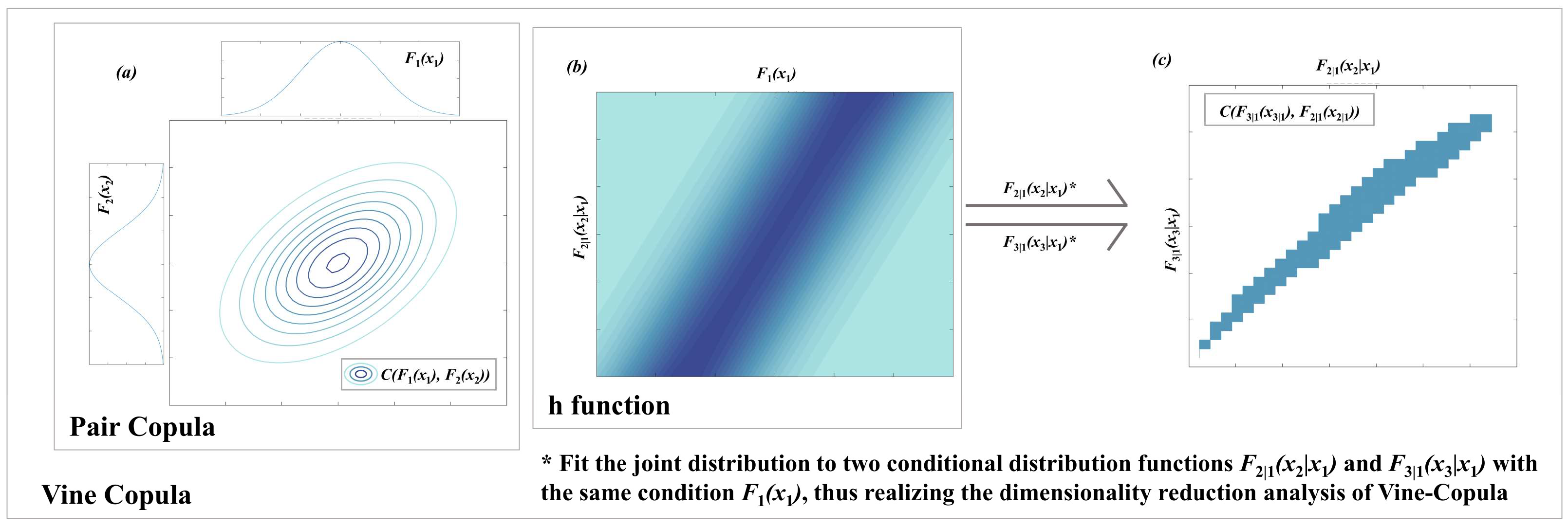
Copula is a multi-dimensional joint distribution function that connects multivariate and univariate marginal distribution in the unit. The multivariate cumulative distribution functions obtained using the Copula operations can model the dependencies between the variables with different marginal distributions. Therefore, Copula can assess the changes in relationships between the variables in a joint distribution (Figure 2a). Based on Sklar’s theorem [35,36], the Copula function can construct the multivariate cumulative distribution function of a uniform marginal distribution function on [0, 1]. Thus, the joint cumulative distribution function can be expressed as follows:
F x 1 , , x n = C F 1 x 1 , , F n x n , θ
where F n x n represents the marginal distribution function of F n on [0, 1]; C denotes an n-dimensional Copula function; and θ stands for a Copula parameter that specifies the degree of dependence between marginal distribution functions. If the marginal distribution function F n x n is continuous, C will be unique. When n = 2, it is called a Pair-Copula model.
In the analysis of Pair-Copula, we constructed the edge distribution density function using the pseudo maximum likelihood method and created an optimal Copula distribution model for each raster point location in the study area. The correlation between the binary variables and the Kendall rank correlation coefficient was determined by using the Akaike information (AIC) and Bayesian information criteria (BIC) and independence test, goodness-of-fit test, and correlation tests. The Copula function distributions of the parameters were also obtained by fitting for subsequent Vine Copula analysis.

3.2.2. AIC Test

The Akaike information criterion (AIC) test is a standard for measuring the goodness of fit of a statistical model and weighs the complexity and accuracy of a model.
A I C = 2 I n L i + 2 k
where k represents the number of parameters, n stands for the sample size, and Li denotes the likelihood function. A large Li value indicates a small AIC value, indicating the good fit of the model. Based on the results of the AIC test, we selected optimal fitting for the Pair-Copula and Vine Copula models.

3.2.3. Kendall’s Rank Correlation Coefficient

Kendall’s rank correlation coefficient [37] is a method for assessing the correlation between two random variables based on the rank of the data objects. When the tau value ( τ ) is equal to 0, the two sets of data are independently distributed; positive correlation refers to when it is greater than 0, and negative correlation denotes when it is less than 0. The expression is
τ = P { X 1 X 2 Y 1 Y 2 > 0 } P { X 1 X 2 Y 1 Y 2 < 0 }
where P { X 1 X 2 Y 1 Y 2 > 0 } represents the consistency between variables, and P { X 1 X 2 Y 1 Y 2 < 0 } denotes the inconsistency between variables. Different Copula families have specific corresponding Kendall rank functions that correlate with the parameters. Therefore, the Kendall rank correlation coefficient was chosen to represent inter-variate dependence.

3.2.4. Vine Copula Model

Vine Copula was first proposed by Joe [36] and then further developed by Aas [33]. It can decompose multi-dimensional joint probability distribution functions into conditional Pair-Copula models and is widely used in non-linear multivariate analysis (Figure 2c). It is expressed as follows:
h x , v , θ = F ( x | v ) = C x v F x , F v F v
f x 1 , x 2 , x 3 = f X 1 x 1 · f X 2 x 2 · f X 3 x 3 Margin   distribution   c X 1 ,   X 3 u X 1 , u X 3 · c X 2 ,   X 3 u X 2 , u X 3           Tree   1       c X 1 , X 2 | X 3 u X 1 | X 3 , u X 2 | X 3           Tree   2
where h x represents the h function (Figure 2b), f x denotes the probability density distribution function, u = F x stands for the cumulative distribution function, and c portrays the density function of the joint distribution function. The joint distribution function for Tree2 can be expressed as follows:
F ( x 1 , x 2 | x 3 ) = C F 1 | 3 x 1 | 3 , F 2 | 3 x 2 | 3 , θ
where F 1 | 3 x 1 | 3 and F 2 | 3 x 2 | 3 represent the conditional marginal distribution functions of the areas subjected to fires and droughts on [0, 1] as a condition of high temperatures. This joint distribution function can represent the correlation between forest fires and drought intensity based on temperature.

3.2.5. Compound Event and the Forest Fire Correlation Index

A compound event refers to two or more adverse episodes that occur simultaneously in the same space and have a specific impact on a social or ecological system. In this study, based on high-temperature and drought events, we proposed a fire hazard index P during compound events. This can be expressed as follows:
F ( FF | T , D ) = C FF , D | T ( u ( F | T ) , u ( D | T ) ) u ( D | T )
P ( F > = 1 | T = t , D = d ) = 1 P F < 1 | T = t , D = d
P F < 1 | T = t , D = d = F ( F | t , d )
where F F , T , and D indicate the units of forest fires, high temperatures, and droughts; t and d denote the values of T and D for different high-temperature and drought scenarios. This method was mainly applied to analyze the correlation between high temperatures, droughts, and forest fires in the study area; it does not apply to extreme events. Therefore, we constructed a new index to analyze the correlation between forest fires and extreme weather events.

3.2.6. Constructing Extremely High Temperature and Drought Indicator

A relative threshold approach was used to construct the extremely high-temperature indicator [38]. We rearranged T max and obtained the   series   { X }. The probability P X that a random value is less than or equal to the rank of that value X m is
P X = m 0.31 / N + 0.38
where m represents the number obtained after rearrangement, and N denotes the number of series { X }.
Let P = 90%, 95%, and 99% in the above equation to obtain m. Xm1 and Xm2, corresponding to the adjacent positive integers m1 and m2 on either side of m, were selected for linear interpolation analysis. The X value represents the corresponding threshold. The data above the 90% threshold were then defined as extremely high temperatures. Extremely high temperatures were classified as Low (value = 1), Medium (value = 2), or High (value = 10) according to the 90%, 95%, and 99% thresholds, and the data below the 90% threshold were considered non-extreme and denoted by 0. Extreme drought was defined in the same way as extremely high temperatures, and three extreme drought levels were calculated and obtained.

3.2.7. Constructing Compound Extreme Event Indicator

The CTDI was constructed from the cumulative distribution function of a single extreme event and a correlation coefficient with the forest fire to represent the degree of danger caused by a composite extreme event [39,40]. This is expressed as follows:
P T = ( P T ) / ( P T + P D )
P D = ( P D ) / ( P T + P D )
CTDI = P T C T , F + P D C D , F
where PT and PD denote the probability densities of the cumulative distribution functions of high temperatures and droughts at the corresponding levels, and they are used to represent the probability of the occurrence of drought and high-temperature events, respectively. C T , F and C D , F denote the Pair-Copula correlation coefficients between high-temperature and drought events and forest fires at the corresponding raster point locations, respectively. They indicate the weights of the correlation between high temperatures, drought events, and forest fires, respectively. Then, the types of compound extreme events were classified according to the range of values. This is expressed as follows:
CTDI l = 0 CTDI 0.2
CTDI m = 0.2 < CTDI 0.7
CTDI h = 0.7 < CTDI 1.0
where C T D I l denotes a compound non-extreme event, C T D I m represents a compound moderately extreme event, and C T D I h stands for a compound highly extreme event. This study analyzed the effects of high temperatures and intense droughts on forest fires in three ways: (1) the effects of high temperatures on forest fires, (2) the effects of drought intensity on forest fires, and (3) the effects of coupled high temperatures and intense droughts on forest fires. The Multivariate Copula Analysis Toolbox [41] of Matlab and the Vine Copula package of R were used for data analysis.

4. Results

4.1. Spatial and Temporal Distribution Characteristics of Forest Fires in Northeast China

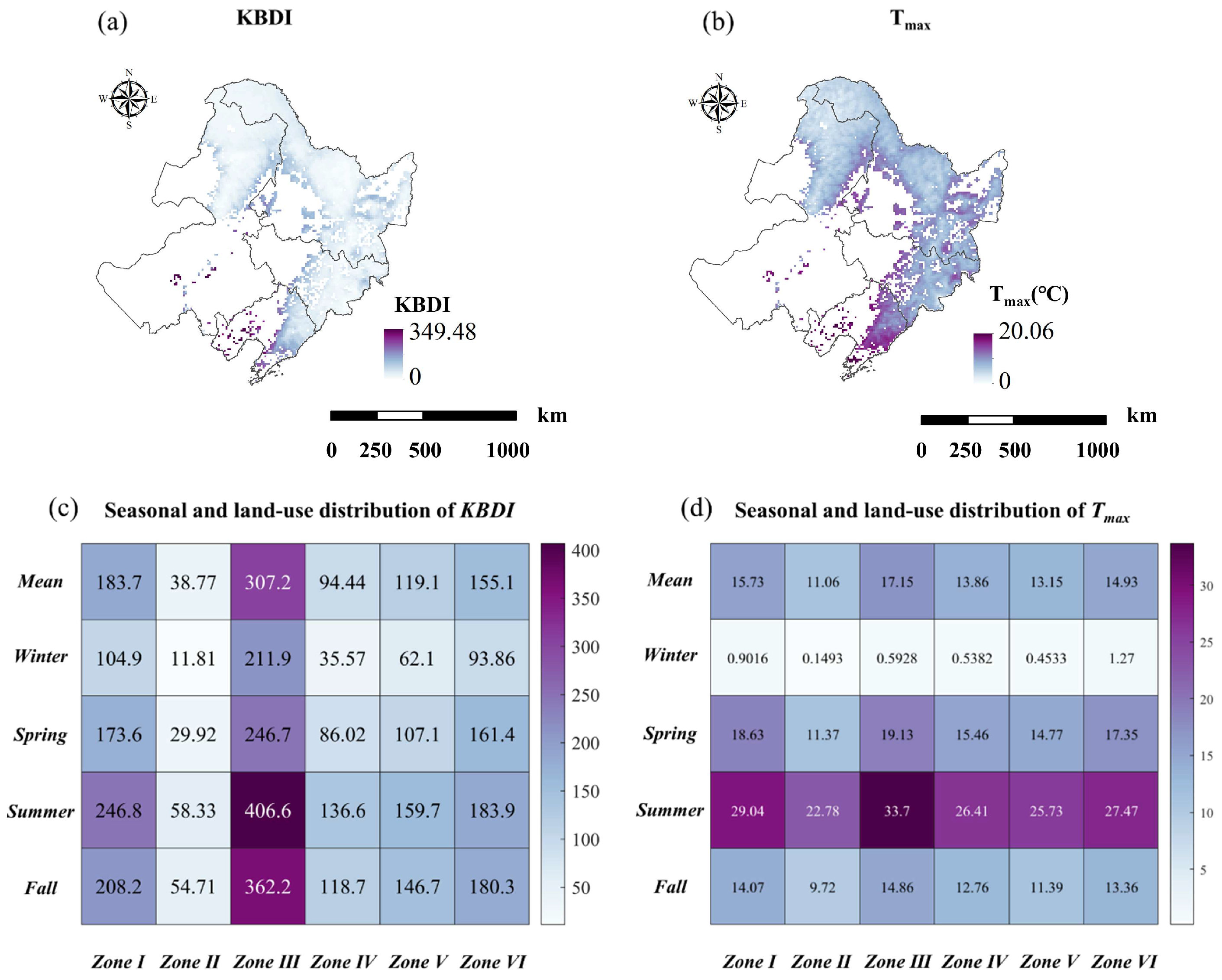
The study area is located in a temperate monsoon climate zone and is highly susceptible to droughts and high-temperature events. Based on meteorological data from the study area (Figure 3a,b), both T max and KBDI show obvious spatial distributional differences, and their frequency varies considerably across the different zones. To further reveal the spatial and temporal distribution characteristics of intense droughts and high temperatures, this study statistically analyzed the seasonal mean values of T max and KBDI in the different zones from 2007 to 2020, as shown in Figure 3c,d.

4.1.1. Temporal and Spatial Analyses of Droughts

In Figure 3c, the maximum value of drought intensity in Zone III occurred in summer at 406.6. However, the minimum value occurred in winter. Meanwhile, the drought intensity in summer and fall was greater than the annual mean value. This means that forest fires in the fall have a strong correlation with droughts. For the transition zone, the highest value of drought intensity occurred in Zone VI, while Zone IV had a lower drought intensity than that of Zone V. This means that the forest fires in Zone V had a strong correlation with drought intensity.

4.1.2. Temporal and Spatial Analyses of High Temperatures

In Figure 3d, the highest temperature in Zone III of 33.7 °C occurred in summer. However, the minimum value occurred in winter. Meanwhile, the highest temperature in spring and summer was greater than the annual mean value. This means that forest fires in spring have a strong correlation with high temperatures. For the transition zone, the highest temperature occurred in Zone VI, while Zone IV had a higher temperature than that in Zone V. This means that the forest fires in Zone IV had a strong correlation with high temperatures.

4.1.3. Temporal and Spatial Analyses of Forest Fires

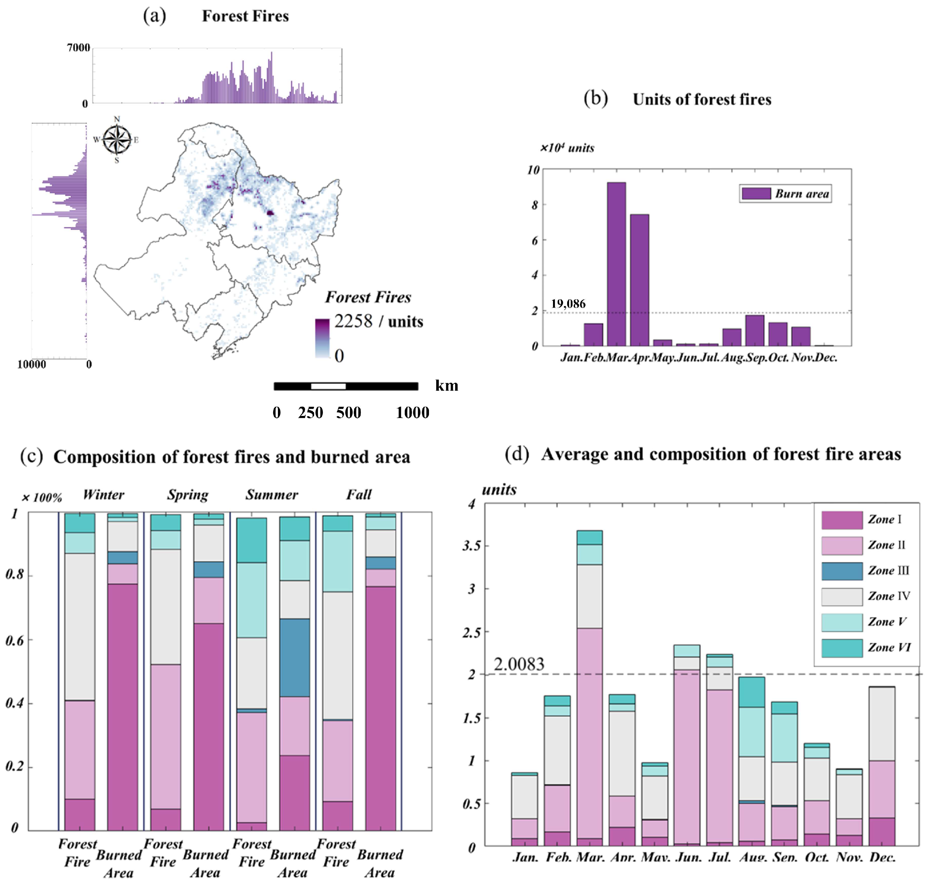
Based on burned area data, this study extracted and analyzed the characteristics of forest fires in Northeast China from 2007 to 2020 (Figure 4). Figure 4c shows the differences in the composition of the forest fire-affected and burned areas. Zones I and III contain more than 50% of the burned areas, which represent less than 10% in the forest fire-affected areas. The largest burned area was 2258 units (203.22 km2), with lots of damage (Figure 4a). The burned areas were mainly concentrated in or around the boundaries of farmland, grassland, and forests rather than in the core of the forest. The eastern boundary of the Daxing’an Mountain forest zone was subjected to more severe forest fires than the western part. This may be caused by the industrial patterns of “east farming and west herding” in the Daxing’an Mountains. The population density and intensity of human activities are high, and man-made forest fires are frequent on the eastern boundary. Moreover, Figure 4b shows that the monthly mean burned area is 19,806 units, with extreme damage, especially in March and April; the total areas both exceed 70,000 units. Conversely, the burned area is close to the mean value in fall and covers the least units in summer.
According to Figure 4b–d, the mean burned area totals 2.0083 units (0.1807 km2). The largest value is more than 3.5 units (0.3150 km2) in March, accounting for 50% of Zone II. In contrast, though the burned area is also large in April, the mean is small, less than one, and Zones I and II account for more than 50%. This indicates that forest fires in April are easily influenced by human activities. The differences in March and April also combine to characterize spring forest fires. Forest fires in June and July show a large, burned area exceeding the mean value, with over 80% of the forest zones. This indicates a high risk of summer forest fires. The burned area in August and September is less than the mean value, accounting for more than 40% of Zone III, suggesting that fall forest fires may be prominent in grassland and grass–forest transition areas. The burned area in winter is smaller than the mean value, composed of more than 50% of Zone I, indicating that winter forest fires are mainly affected by human activities.

4.2. Copula Correlation between High Temperatures, Drought Intensity, and Forest Fires in Northeast China

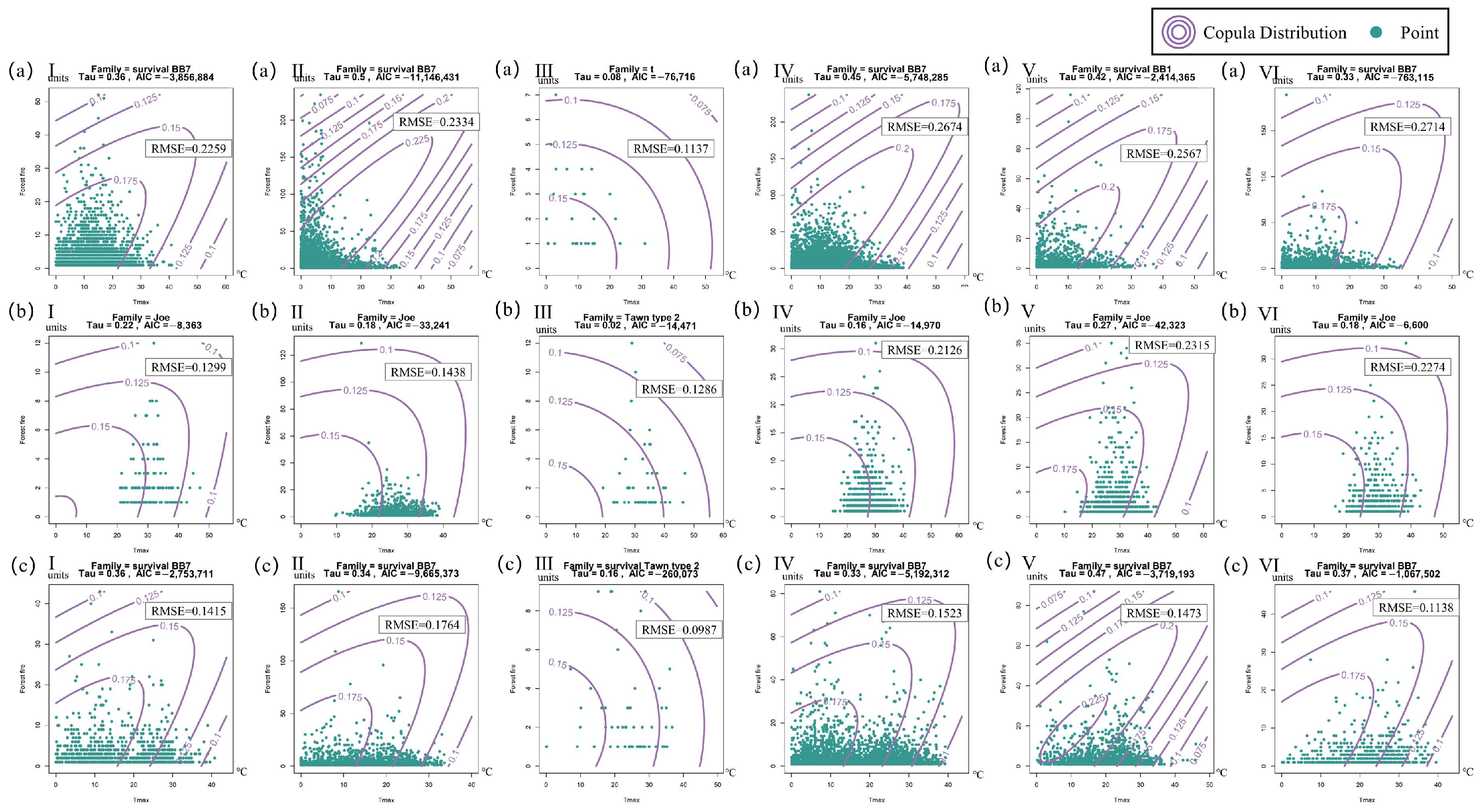
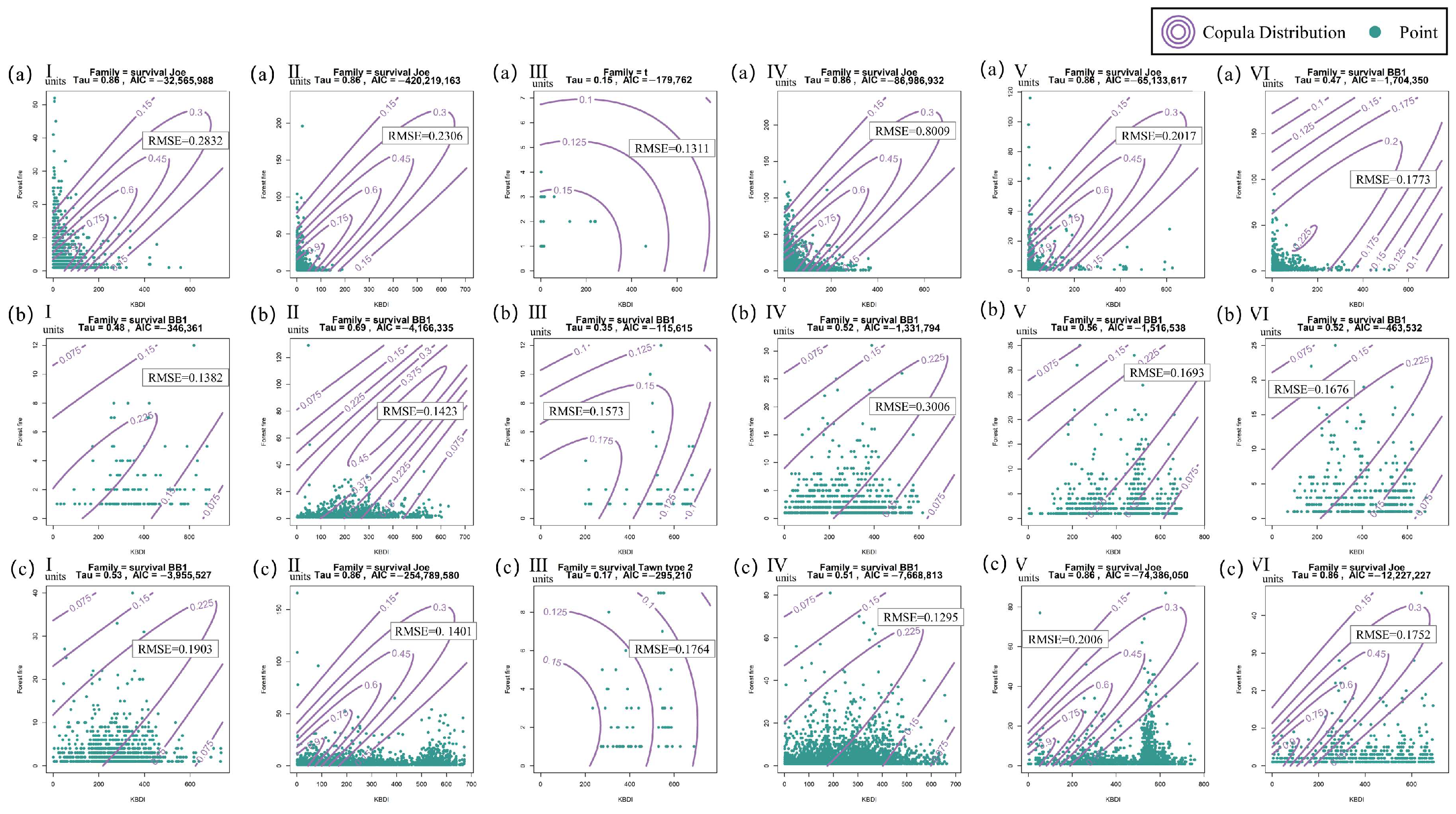
The Copula correlation of high temperatures and drought intensity with the forest fires is shown in Figure 5 and Figure 6. The AIC test and RMSE values are reasonable, and the p-values are less than 0.01, indicating reliability, goodness of fit, and predictive accuracy. Meanwhile, the tau values are all greater than 0, indicating a positive correlation between high temperatures, intense droughts, and forest fires in all the scenarios. A high tau value represents a strong positive correlation. The large value of the contour indicates numerous extreme events that are concentrated in the center; the dense contours indicate the concentrated distribution of extreme events. The scatter plots in Figure 5 and Figure 6 represent the distribution of high temperatures and intense droughts corresponding to forest fires during different seasons and in all the zones, respectively. Because of the poor correlation of forest fires with high temperatures and droughts in winter, no further discussion between these three factors will follow.
As shown in Figure 5, the correlation between the burned areas and high temperatures is stronger in spring and fall than it is in summer, indicating that the forest fire danger rises with increasing temperatures in spring and fall. In contrast, due to the prevalent occurrence of high temperatures, there is no significant increase in forest fire danger in summer. As shown in Figure 6, the correlation between droughts and fires is stronger in the forested areas (Zones I, IV, V, and VI), and that in spring is generally stronger than that in summer and fall. Meanwhile, unlike those in summer and fall, forest fires in spring have strong positive correlations with high temperatures and droughts, and most of the largest areas were burned during periods of lower temperatures and fewer droughts. This suggests that forest fires with different ignition sources have different characteristics in spring.

4.3. Vine Copula Correlation between High Temperatures, Intense Droughts, and Forest Fires in Northeast China

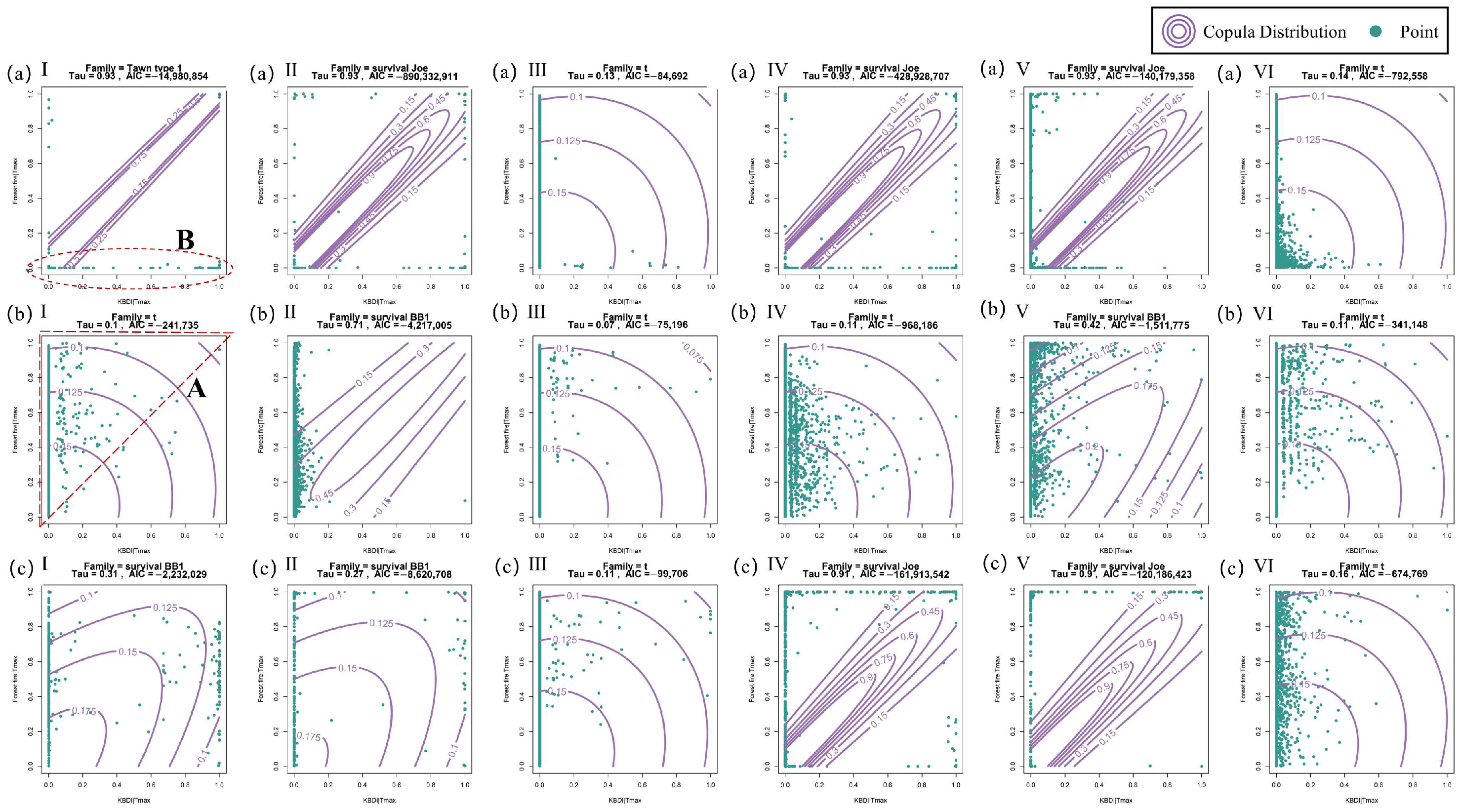
Pair-Copula could only analyze the 2D correlation between high temperatures or droughts and forest fires. This study used Vine Copula to analyze the 3D correlation between high temperatures, droughts, and forest fires. Figure 7 shows the Copula correlation between drought intensity and forest fires under high-temperature conditions. The AIC test values are reasonable, and the p-values are less than 0.01, indicating a reliable goodness of fit. Meanwhile, the tau values are all greater than 0, indicating that drought intensity and forest fires still maintain a positive correlation after removing the effect of high temperatures.
Compared with Figure 6b (Zone II), the forest fires in the different areas shown in Figure 7b (Zone II) are densely distributed with a low drought intensity, indicating that this factor did not lead to the forest fires after removing the effect of high temperatures. This means that the forest fires were dominated by high temperatures in summer.
As shown in Figure 7, the number of higher hazard events gradually increased during more droughts in summer and fall (A). In contrast, the different forest fires in spring show great variability. In addition to the type of forest fires mentioned above, low-risk forest fires do not have a significantly positive correlation with droughts (B). This suggests that low-risk forest fires are less affected by droughts and high temperatures in spring and are mainly caused by human activities and production.

4.4. Copula Correlation between Extremely High Temperatures, Intense Droughts, and Forest Fires in Northeast China

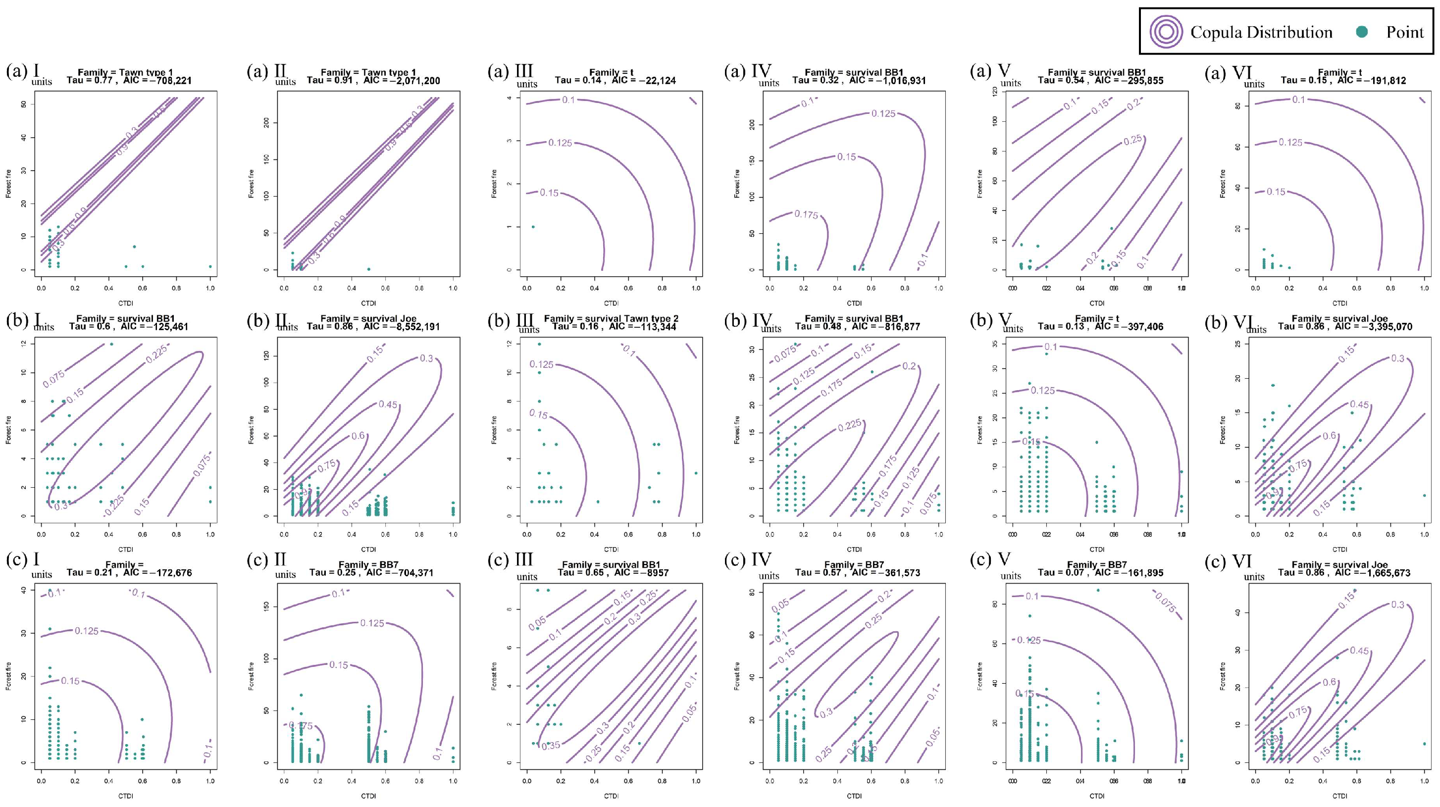
This section demonstrates the Copula correlation between the compound events of extremely high temperatures, intense droughts, and forest fires, and the results are shown in Figure 8. The AIC test values are reasonable, and the p-values are less than 0.01, indicating a reliable goodness of fit. Meanwhile, the tau values are all greater than 0, indicating that there is a positive correlation between the compound extreme events and the forest fires. As can be seen in Figure 8, the scatter plot extensions x are divided into three parts, representing low, medium, and high CTDI events, respectively.
Compared to Figure 5 and Figure 6, the forest fires during compound extreme events are generally smaller than those during non-extreme events. In spring, the largest forest fire during compound extreme events was less than 50 units, which is only a quarter of the size of that under non-extreme conditions, while in summer and fall, the value during compound extreme events is half of that under non-extreme conditions. It is speculated that summer and fall have the highest seasonal forest fire risks.

5. Discussion

5.1. The Forest Fire Hazard under High-Temperature and Drought Conditions

Through the above analysis, this study analyzed the forest fire hazard under intense drought and high-temperature scenarios in different seasons. As shown in Figure 9a (I–VI), spring forest fire hazards over 0.5 were widely distributed in the study area, while they were mainly distributed in the regions with high temperatures and droughts with hazards below 0.5 and 0.1. The low- and high-hazard forest fires in spring had similar distribution characteristics and occurred more in the areas with more cropland and grassland. This is due to the fact that spring is the planting season, so human activities are more frequent, resulting in an increase in mobile fires [42]. At the same time, in areas with less forested land, the environment is drier, and the moisture content of combustible materials is lower, which is conducive to the occurrence and spread of fires, and this makes it easy for high-risk fires to occur [43]. In Zones III and VI, spring low-risk forest fires were also distributed during extreme droughts, which showed hazard values for seasonal droughts above 0.7 and high temperatures over 0.8. This indicates that another type of forest fire in spring occurs in regions with extreme droughts and relatively minimal human activities. This also suggests that the extremely high temperatures in spring can also lead to an increase in the risk of fire, especially in areas with lots of grassland. This is because high temperatures cause water evaporation, so the moisture content of the environment decreases, and grasslands are the driest in the spring, which is conducive to the formation and spread of fires [43,44].
As shown in Figure 9b (I–VI), the summer forest fire hazards first increase and then decrease with rising temperatures. The relationship between drought intensity and the forest fire hazard is weak in the same zone, but a high risk is present in severe drought-afflicted areas in different zones. This indicates a strong correlation between summer droughts, high temperatures, and forest fires, and the effect is obvious under the influence of high temperatures. On the one hand, high temperatures in the summer can lead to combustibles catching fire and promote evaporation, making them drier and more flammable [43]; on the other hand, despite more precipitation during summer, high temperatures in summer are generally of a continuous nature, and the interaction of sustained high temperature and droughts can further exacerbate the hazard of forest fire [42].
As shown in Figure 9c (I–VI), the forest fire hazard in autumn is very similar to that in spring. Forest fire hazards below 0.5 were widely distributed under a high drought intensity, and those near 0.5 were more frequent than in spring. This indicates that compared with spring forest fires, fall forest fires were more affected by droughts, the hazards were more uniform, and there were fewer fires. However, the generally dry vegetation and windy environment in the study area in fall are conducive to the spread and formation of forest fires, including large ones [45].

5.2. Probability of Forest Fires under Compound High Temperatures and Droughts

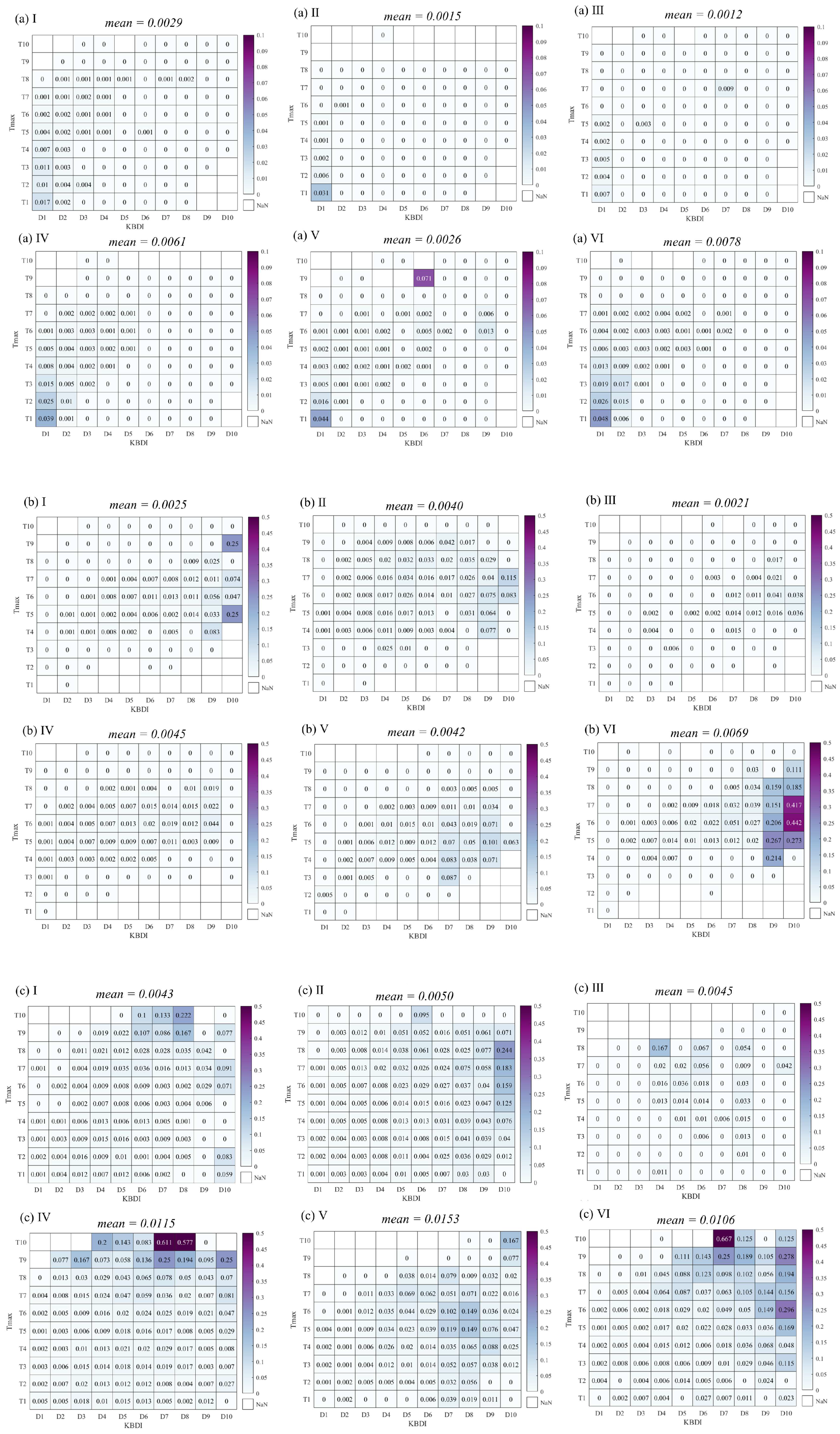
The probability of a forest fire during compound events is shown in Figure 9. D1–D10 and T1–T10, respectively, indicate the gradual intensification of droughts and high temperatures. In spring (Figure 9a (I–VI)), forest fires are more likely to occur in D1 and T1, and the relationship between drought intensity and high temperatures shows a sub-diagonal distribution. This indicates that the forest fire probability is greater than 0 under high temperatures and minor droughts. This means that the key affecting factor is temperature. Since there are fewer lightning strikes in spring, the rising temperatures in spring affect human activities, resulting in man-made fires [46]. In Zones III and V, the highest forest fire probability occurred during springtime extreme droughts and high temperatures in D7 and T7 and D6 and T9. This indicates that another category of forest fire occurs in spring during seasonal extreme droughts and high temperatures [47].
As shown in Figure 10b (I) and Figure 10c (VI), the correlation between forest fires and compound high temperatures and droughts was similar in summer and fall. They both had a high probability of occurring under these extreme conditions (D5, T5). The difference is that high temperatures have a large impact on forest fires in summer, while this is not significant in fall. Meanwhile, the highest probability in summer is 0.0069 in Zone VI, the minimum value is 0.0021 in Zone III, and the probability of forest fires in the forested land (Zones II, IV, V, and VI) is more than twice as high as that in the non-forested land. The highest probability in fall is 0.0153 in Zone V, the minimum value is 0.0043 in Zone I, and the probability of a forest fire in the junction area (Zones IV, V, and VI) is more than twice as high as that in a single area. This suggests that although the probability of forest fires in summer is relatively low, they exhibit a higher hazard in forested areas, with persistent high temperatures and droughts [43,47]. In contrast, forest fires in fall are likely to be more often the result of spreading. Therefore, fire prevention and management efforts need to be strengthened, especially during windy weather in areas where there is significantly more vegetation and grassland in fall.

5.3. Seasonal and Spatial Distribution of the Forest Fire Hazard

Additionally, this study further assessed the hazard based on historical fires in the study area from 2007 to 2020, and the results are shown in Figure 11. In Figure 11a, in spring, the areas of medium–high- and high-level fire hazards are primarily found in forests (85.96%) and the margin, accounting for Zones III (95.45%) and VI (96.85%). Additionally, the closer one goes to the core, the higher the risk is. This suggests that despite the excessive anthropogenic disturbance causing spring forest fires, droughts and high temperatures are still important influencing factors [42].
The risk is generally high in summer (Figure 11b), with medium–high- (66.59%) and high-level (10.27%) hazard areas distributed within each zone. However, the hazard in the core is lower than that in the margin. Sustained high temperatures during summer have a greater impact on the junction zones, and droughts caused by sustained high temperatures can pose a higher fire hazard in these zones [48].
In Figure 11c, the fall forest fire hazard is low as a whole. However, the medium–high- and high-level hazard areas are concentrated in the marginal areas of the forest, such as Zones I (99.83%) and III (95.45%). Fall environments are generally dry and windy, meaning that forest fires spread easily, so the figure shows a higher risk in these zones.

5.4. Probability of Forest Fires under Compound Extremely High Temperatures and Droughts

In terms of the results, 69.88% of the compound extreme events occurred in summer; 47.9% occurred in Zone III; and 32.25% in Zone I. At the same time, the compound extreme events occurred continuously. About 60% of the compound extreme events occurred within a day’s interval before or after another event. Additionally, the largest value is 65.22% in Zone III. This conclusion is also consistent with the results shown in Figure 3. However, the probability of forest fires is low in Zone III, as shown in Figure 12. This is because grassland fires spread easily and are less affected by high temperatures. In addition, grassland fires are more influenced by the water content of vegetation than by high temperatures [49].
On the one hand, the probability of forest fires in Zones I and IV is lower during compound extremes. On the other hand, compared with a non-extreme scenario, the probability of forest fires is significantly increased, with values of 29.73% and 155.56% in the same period in summer. This indicates that although the forest fires in these zones are mainly influenced by human production and life, on the other hand, the occurrence of compound extreme weather also increases the probability [42,43,44].
Compared with the results shown in Figure 10, the probability of forest fires in Zones II, V, and VI increased, especially in summer, when the probability was more than twice as high as that in a non-extreme scenario. Meanwhile, the probability of forest fires increases significantly with the increase in the severity of compound events. This indicates that extremely high temperatures and droughts further contribute to the occurrence of forest fires [47]. In the context of global warming, this effect will be further exacerbated as climate extremes intensify.

5.5. Perspectives and Limitations

From the analysis of this study, it is clear that there are significant differences between forest fires and high temperatures and droughts in various regions throughout seasons. Therefore, in fire management, we must focus on identifying and monitoring high-risk fire periods in different zones.
For Zone I, the forest fires mainly occur in spring, which is the period most affected by human activities. This is closely related to high temperatures, and there are a large number of areas where non-forest fires could start. Therefore, we need to pay special attention to human production and domestic fires in spring and carry out effective control to prevent the formation of forest fires. Zone II is the core forested area, which is minimally disturbed by human activities. When a fire occurs, it is difficult to control, so preventive work can be carried out in advance by removing surface combustibles and constructing firebreaks and other obstacles during the non-fire season. At the same time, there are many fires in spring and summer in this zone, which are the periods most affected by extreme compound events, so it is necessary to focus on the fire danger when extreme events occur. Zones III and V are less frequently affected by human activity and are susceptible to drought, which is conducive to the spread of fire. Here, there is a higher fire risk in the fall, requiring increased regulation during periods of sustained heat or droughts. Both these zones need to be monitored more closely during periods of sustained high temperature or droughts in fall. Zones IV and VI have experienced the highest number of fires per unit, 113.8 and 102.2, respectively. Both these zones are affected by more human activities, as well as significant climate change, and show a high fire risk in all three seasons. Therefore, these two regions need to be prioritized for fire prevention and control.
At the same time, our study also has certain limitations. On the one hand, the low spatial resolution could have hidden unique characteristics of regional fires [50]. For example, it is not possible to make an effective distinction between the origin and the spread of a fire, and the responses to them are somewhat different; on the other hand, the responses of different tree species to fire will also affect its size, scale, and the danger posed to some extent. These two points can be used as future research directions to explore the deep relationship between forest fires, the climate, and vegetation during climate change.

6. Conclusions

In this study, the spatial and temporal distribution patterns of high temperatures, droughts, and forest fires in the study area were obtained using daily T max , KBDI , and fire data sources. The Copula model and CTDI were used to analyze the correlation between high temperatures and droughts and forest fires. On this basis, the fire hazards in different zones during various seasonal composite events were assessed. The results of this study can provide a reference for government decision-making and disaster prevention and mitigation.
The conclusions are as follows:
  • In Northeast China, the proportion of forest fires in spring is 71.56%; in fall, it is 17.45%; in winter, it is 5.81%; and in summer, it is 5.18%. Meanwhile, forest fires burned in cropland, forest, grassland, and junction zones and showed different compositions in the different seasons, with most of them being dominated by Zones II (40.48%) and VI (36.59%).
  • In spring, summer, and fall, forest fires are more strongly correlated with droughts than high temperatures in all the zones. The maximum correlation values are 0.86 with droughts and 0.5 with high temperatures. The Copula correlations between high temperatures, droughts, and forest fires are stronger in fall than in spring in Zones III, V, and VI.
  • Between 2007 and 2020, forest fires occurred mainly during non-extreme climate events in Northeast China. They were subject to the combined effects of human activities and climate change. The fire events in Zone II were influenced by climate change throughout the spring, summer, and fall.
  • The forest fire probabilities during compound extreme events were low in spring and high in summer and fall. In the extreme scenario, the probability is higher in fall than it is in summer. However, compound extreme events were frequent and intense in summer. This is consistent with the trend of changing forest fire patterns and longer fire seasons in Northeast China under climate change.

Author Contributions

B.M. and X.L. designed the study, data preparation, data processing and analysis, and wrote the paper. J.Z., Z.T. and X.W. reviewed the manuscript and improved the English language. X.L. and B.M. provided the project design and the paper editing. All authors have read and agreed to the published version of the manuscript.

Funding

This work was funded by National Key R&D Program of China (2022YFC3003001).

Data Availability Statement

Data will be made available upon request.

Acknowledgments

Thanks to the anonymous reviewers for their helpful suggestions and comments.

Conflicts of Interest

The authors declare no conflicts of interest.

References

  1. Bowman, D.M.J.S.; Balch, J.K.; Artaxo, P.; Bond, W.J.; Carlson, J.M.; Cochrane, M.A.; D’Antonio, C.M.; Defries, R.S.; Doyle, J.C.; Harrison, S.P.; et al. Fire in the Earth System. Science 2009, 324, 481–484. [Google Scholar] [CrossRef] [PubMed]
  2. Sommers, W.T.; Loehman, R.A.; Hardy, C.C. Wildland fire emissions, carbon, and climate: Science overview and knowledge needs. Forest Ecol. Manag. 2014, 317, 1–8. [Google Scholar] [CrossRef]
  3. Luo, R.S.; Hui, D.F.; Miao, N.; Liang, C.; Wells, N. Global relationship of fire occurrence and fire intensity: A test of intermediate fire occurrence-intensity hypothesis. J. Geophys. Res.-Biogeosci. 2017, 122, 1123–1136. [Google Scholar] [CrossRef]
  4. Anderegg, W.R.L.; Kane, J.M.; Anderegg, L.D.L. Consequences of widespread tree Mortality triggered by drought and temperature stress. Nat. Clim. Chang. 2013, 3, 30–36. [Google Scholar] [CrossRef]
  5. Xu, X.Y.; Jia, G.S.; Zhang, X.Y.; Riley, W.J.; Xue, Y. Climate regime shift and forest loss amplify fire in Amazonian forests. Global Chang. Biol. 2020, 26, 10. [Google Scholar] [CrossRef]
  6. Abatzoglou, J.T.; Williams, A.P.; Barbero, R. Global Emergence of Anthropogenic Climate Change in Fire Weather Indices. Geophys. Res. Lett. 2019, 46, 326–336. [Google Scholar] [CrossRef]
  7. Chapman, S.; Syktus, J.; Trancoso, R.; Salazar, A.; Thatcher, M.; Watson, J.E.M.; Meijaard, E.; Sheil, D.; Dargusch, P.; McAlpine, C.A. Compounding impact of deforestation on Borneo’ s climate during El Niño events. Environ. Res. Lett. 2020, 15, 8. [Google Scholar] [CrossRef]
  8. Fan, J.; Liu, B.Y.; Ming, X.D.; Sun, Y.; Qin, L.J. The amplification effect of unreasonable human behaviours on natural disasters. Humanit. Soc. Sci. Commun. 2022, 9, 322. [Google Scholar] [CrossRef]
  9. Westerling, A.L.; Hidalgo, H.G.; Cayan, D.R.; Swetnam, T.W. Warming and earlier spring increase western U.S. forest wildfire activity. Science 2006, 313, 940–943. [Google Scholar] [CrossRef]
  10. Hu, H.Q.; Wei, S.J.; Wei, S.W. Effect of Fire Disturbance on Forest Ecosystem Carbon Cycle under the Background of Climate Warming. J. Catastrophol. 2012, 27, 37–41. [Google Scholar]
  11. Galizia, L.F.; Barbero, R.; Rodrigues, M.; Ruffault, J.; Pimont, F.; Curt, T. Global Warming Reshapes European Pyroregions. Earth’s Future 2023, 11, 5. [Google Scholar] [CrossRef]
  12. Yin, J.P.; He, B.B.; Fan, C.Q.; Chen, R.; Zhang, H.G.; Zhang, Y.R. Drought-related wildfire accounts for one-third of the forest wildfires in subtropical China. Agric. For. Meteorol. 2024, 346, 109893. [Google Scholar] [CrossRef]
  13. Ahmad, S.K.; Holmes, T.R.; Kumar, S.V.; Lahmers, T.M.; Liu, P.W.; Nie, W.S.; Getirana, A.; Orland, E.; Bindlish, R.; Guzman, A.; et al. Droughts impede water balance recovery from fires in the Western United States. Nat. Ecol. Evol. 2024, 8, 229–238. [Google Scholar] [CrossRef] [PubMed]
  14. Walden, L.; Fontaine, J.B.; Ruthrof, K.X.; Matusick, G.; Harper, R.J. Drought then wildfire reveals a compound disturbance in a resprouting forest. Ecol. Appl. 2023, 33, 2. [Google Scholar] [CrossRef]
  15. Fischer, E.M.; Sippel, S.; Knutti, R. Increasing probability of record-shattering climate extremes. Nat. Clim. Chang. 2021, 11, 689. [Google Scholar] [CrossRef]
  16. Ermitao, T.; Gouveia, C.M.; Bastos, A.; Russo, A.C. Interactions between hot and dry fuel conditions and vegetation dynamics in the 2017 fire season in Portugal. Environ. Res. Lett. 2022, 17, 9. [Google Scholar] [CrossRef]
  17. Whitman, E.; Parks, S.A.; Holsinger, L.M.; Parisien, M.A. Climate-induced fire regime amplification in Alberta, Canada. Environ. Res. Lett. 2022, 17, 5. [Google Scholar] [CrossRef]
  18. Slavskiy, V.; Litovchenko, D.; Matveev, S.; Sheshnitsan, S.; Larionov, M.V. Assessment of Biological and Environmental Factors Influence on Fire Hazard in Pine Forests: A Case Study in Central Forest-Steppe of the East European Plain. Land 2023, 12, 103. [Google Scholar] [CrossRef]
  19. Mansoor, S.; Farooq, I.; Kachroo, M.M.; Mahmoud, A.E.; Fawzy, M.; Popescu SMAlyemeni, M.N.; Sonne, C.; Rinklebe, J.; Ahmad, P. Elevation in wildfire frequencies with respect to the climate change. J. Environ. Manag. 2021, 301, 113769. [Google Scholar] [CrossRef]
  20. Wang, Y.N.; Wang, H.Q.; He, Y.M. Analysis on Temporal and Spatial Distribution and Influencing Factors of Forest Fire in China from 2010 to 2020. J. Shandong For. Sci. Technol. 2022, 5, 26–38. Available online: https://kns.cnki.net/kcms2/article/abstract?v=3uoqIhG8C44YLTlOAiTRKibYlV5Vjs7iJTKGjg9uTdeTsOI_ra5_XTqC0hXDTx9xa5GB3tQbB3i9a1Myw_mlEynbBDOKHzjL&uniplatform=NZKPT (accessed on 22 March 2023).
  21. Ridder, N.N.; Pitman, A.J.; Westra, S.; Ukkola, A.; Hong, X.D.; Bador, M.; Hirsch, A.L.; Evans, J.P.; Di Luca, A.; Zscheischler, J. Global hotspots for the occurrence of compound events. Nat. Commun. 2021, 11, 5956. [Google Scholar] [CrossRef] [PubMed]
  22. Zhou, X.; Yang, J.; Niu, K.L.; Zou, B.S.; Lu, M.J.; Wang, C.Y.; Wei JYLiu, W.; Yang, C.X.; Huang, H.L. Assessment of the Forest Fire Risk and Its Indicating Significances in Zhaoqing City Based on Landsat Time-Series Images. Forest 2023, 14, 327. [Google Scholar] [CrossRef]
  23. Salomón, R.L.; Peters, R.L.; Zweifel, R.; Sass-Klaassen, U.G.W.; Stegehuis, A.I.; Smiljanic, M.; Poyatos, R.; Babst, F.; Cienciala, E.; Fonti, P. The 2018 European heat wave led to stem dehydration but not to consistent growth reductions in forests. Nat. Commun. 2022, 13, 28. [Google Scholar] [CrossRef] [PubMed]
  24. Furniss, T.J.; Das, A.J.; Mantgem, P.J.; Stephenson, N.L.; Lutz, J.A. Crowding, climate, and the case for social distancing among trees. Ecol. Appl. 2022, 32, 2. [Google Scholar] [CrossRef]
  25. Forzieri, G.; Dakos, V.; McDowell, N.G.; Ramdane, A.; Cescatti, A. Emerging signals of declining forest resilience under climate change. Nature 2022, 608, 534. [Google Scholar] [CrossRef]
  26. Feng, Y.; Liu, W.B.; Sun, F.B.; Wang, H. Changes of compound hot and dry extremes on different land surface conditions in China during 1957–2018. Int. J. Climatol. 2020, 41, 1085–1099. [Google Scholar] [CrossRef]
  27. Szpakowski, D.M.; Jensen, J.L.R.; Butler, D.R.; Chow, T.E. A study of the relationship between fire hazard and burn severity in Grand Teton National Park, USA. Int. J. Appl. Earth Obs. 2021, 98, 102305. [Google Scholar] [CrossRef]
  28. Xu, K.; Huang, S.M.; He, F.L. Modeling fire hazards for the maintenance of long-term forest inventory plots in Alberta, Canada. Forest Ecol. Manag. 2021, 513, 120206. [Google Scholar] [CrossRef]
  29. Farrokhi, A.; Farzin, S.; Mousavi, S.F. Meteorological drought analysis in response to climate change conditions, based on combined four-dimensional vine copulas and data mining (VC-DM). J. Hydrol. 2021, 603, 127135. [Google Scholar] [CrossRef]
  30. Li, H.W.; Li, Y.P.; Huang, G.H.; Sun, J. Quantifying effects of compound dry-hot extremes on vegetation in Xinjiang (China) using a vine-copula conditional probability model. Agric. For. Meteorol. 2021, 311, 108658. [Google Scholar] [CrossRef]
  31. Wu, H.J.; Su, X.L.; Singh, V.P.; Feng, K.; Niu, J.P. Agricultural Drought Prediction Based on Conditional Distributions of Vine Copulas. Water Resour. Res. 2021, 57, 8. [Google Scholar] [CrossRef]
  32. Zhou, S.; Yu, B.F.; Zhang, Y. Global concurrent climate extremes exacerbated by anthropogenic climate change. Sci. Adv. 2023, 9, 10. [Google Scholar] [CrossRef] [PubMed]
  33. Aas, K.; Czado, C.; Frigessi, A.; Bakken, H. Pair-copula constructions of multiple dependence. Insur. Math. Econ. 2009, 44, 182–198. [Google Scholar] [CrossRef]
  34. Dissmann, J.; Brechmann, E.C.; Czado, C.; Kurowicka, D. Selecting and estimating regular vine copulae and application to financial returns. Comput. Stat. Data Anal. 2013, 59, 52–69. [Google Scholar] [CrossRef]
  35. Sklar, M. Fonctions de répartition à n dimensions et leurs marges. Publ. L’Institut Stat. L’Univ. Paris 1959, 8, 229–231. [Google Scholar]
  36. Joe, H. Multivariate Models and Dependence Concepts; Chapman and Hall: London, UK, 1997. [Google Scholar]
  37. Kendall, M. A new measure of rank correlation. Biometrika 1938, 30, 81–93. [Google Scholar] [CrossRef]
  38. Bonsal, B.R.; Zhang, X.; Vincent, L.A.; Hogg, W.D. Characteristics of daily and extreme temperatures over Canada. J. Clim. 2001, 14, 1959–1976. [Google Scholar] [CrossRef]
  39. Keetch, J.J.; Byram, G.M. A Drought Index for Forest Fire Control; USDA Forest Services Research: Washington, DC, USA, 1968; Volume 38, p. SE-38. Available online: https://www.srs.fs.usda.gov/pubs/rp/rp_se038.pdf (accessed on 22 March 2023).
  40. Wang, W.J.; Zhang, Y.Q.; Guo, B.; Ji, M.; Xu, Y. Compound Droughts and Heat Waves over the Huai River Basin of China: From a Perspective of the Magnitude Index. J. Hydrometeorol. 2022, 22, 3107–3119. [Google Scholar] [CrossRef]
  41. Mojtaba, S.; Elisa, R.; Amir, A. Multivariate Copula Analysis Toolbox (MvCAT): Describing dependence and underlying uncertainty using a Bayesian framework. Water Resour. Res. 2017, 53, 6. [Google Scholar] [CrossRef]
  42. Shi, Z.T.; Jiang, D.B.; Wang, Y.L. Spatiotemporal dependence of compound drought-heatwave and fire activity in China. Weather Clim. Extrem. 2024, 45, 100695. [Google Scholar] [CrossRef]
  43. Griebel, A.; Boer, M.M.; Blackman, C.; Choat, B.; Ellsworth, D.S.; Madden, P. Specific leaf area and vapour pressure deficit control live fuel moisture content. Funct. Ecol. 2023, 37, 719–731. [Google Scholar] [CrossRef]
  44. Canadell, J.G.; Meyer, C.P.; Cook, G.D.; Dowdy, A.; Briggs, P.R.; Knauer, J.; Pepler, A.; Haverd, V. Multi-decadal increase of forest burned area in Australia is linked to climate change. Nat. Commun. 2021, 12, 6921. [Google Scholar] [CrossRef] [PubMed]
  45. Arizpe, A.H.; Falk, D.A.; Woodhouse, C.A.; Swetnam, T.W. Widespread fire years in the US-Mexico Sky Islands are contingent on both winter and monsoon precipitation. Int. J. Wildland Fire 2020, 29, 1072–1087. [Google Scholar] [CrossRef]
  46. Li, W.K.; Shu, L.F.; Wang, M.Y.; Li, W.; Si, L.Q.; Zhao, F.J.; Li, X.X.; Zhou, N.Y. Occurrence Pattern and Changing Trend of Lightning Induced Fires and Human-caused Fires in Daxing’anling Forest Region of Heilongjiang Province. Sci. Silvae Sin. 2024, 4, 136–146. [Google Scholar]
  47. Libonati, R.; Geirinhas, J.L.; Silva, P.S.; Russo, A.; Rodrigues, J.A.; Belém, L.B.C.; Nogueira, J.; Roque, F.O.; DaCamara, C.C.; Nunes, A.M.B.; et al. Assessing the role of compound drought and heatwave events on unprecedented 2020 wildfires in the Pantanal. Environ. Res. Lett. 2022, 17, 015005. [Google Scholar] [CrossRef]
  48. Zhao, F.J.; Liu, Y.Q.; Shu, L.F. Change in the fire season pattern from bimodal to unimodal under climate change: The case of Daxing’anling in Northeast China. Agric. For. Meteorol. 2020, 291, 108075. [Google Scholar] [CrossRef]
  49. Wang, Z.; Huang, R.; Yao, Q.C.; Zong, X.Z.; Tian, X.R.; Zheng, B.; Trouet, V. Strong winds drive grassland fires in China. Environ. Res. Lett. 2023, 18, 015005. [Google Scholar] [CrossRef]
  50. Yan, Y.C.; Piao, S.L.; Hammond, W.M.; Chen, A.P.; Hong, S.B.; Xu, H.; Munson, S.M.; Myneni, R.B.; Allen, C.D. Climate-induced tree-mortality pulses are obscured by broad-scale and long-term greening. Nat. Ecol. Evol. 2024, 8, 912–923. [Google Scholar] [CrossRef]
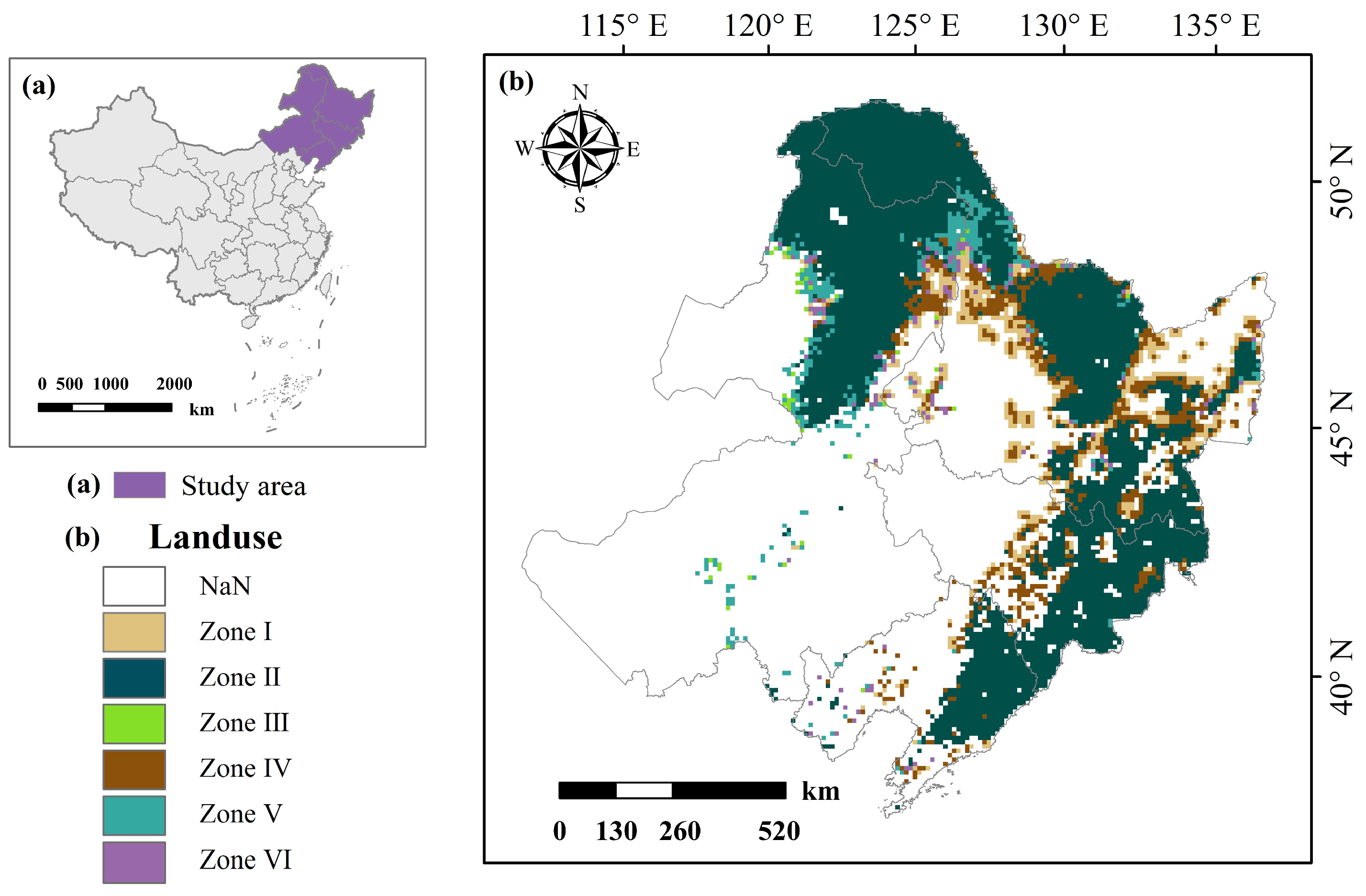
Figure 1. The study area. (a) The study area in China; (b) the spatial distribution of six zones in the study area.
Remotesensing 16 03784 g001
Figure 2. The Copula method; (a) the joint distribution function C(F1(x1), F2(x2)) for F1(x1) and F2(x2); (b) F2(x2)’s conditional distribution function F2|1(x2|x1) conditional on F1(x1); (c) the joint distribution function C(F3|1(x3|1), F2|1(x2|1)) for F2|1(x2|x1) and F3|1(x3|x1).
Remotesensing 16 03784 g002
Figure 3. Seasonal spatial distribution of intense droughts (a,c) and high temperatures (b,d) in Northeast China.
Remotesensing 16 03784 g003
Figure 4. Characteristics of forest fires in Northeast China. (a) The spatial distribution of forest fires; (b) the seasonal distribution of forest fires; (c) the composition of forest fires and burned areas; (d) the average and composition of forest fire areas.
Remotesensing 16 03784 g004
Figure 5. Copula correlation of high temperatures and forest fires (seasonal distribution in rows for (a) spring, (b) summer and (c) fall; zone distribution in columns for Zone I to Zone VI, p < 0.01).
Remotesensing 16 03784 g005
Figure 6. Copula correlation of droughts and forest fires (seasonal distribution in rows for (a) spring, (b) summer and (c) fall; zone distribution in columns for Zone I to Zone VI, p < 0.01).
Remotesensing 16 03784 g006
Figure 7. Copula correlation of drought intensity and forest fires under high-temperature condition (seasonal distribution in rows for (a) spring, (b) summer and (c) fall; zone distribution in columns for Zone I to Zone VI, p < 0.01).
Remotesensing 16 03784 g007
Figure 8. Copula correlation between extremely high−temperature and drought events and forest fires in Northeast China (seasonal distribution in rows for (a) spring, (b) summer and (c) fall; zone distribution in columns for Zone I to Zone VI, p < 0.01).
Remotesensing 16 03784 g008
Figure 9. The fire hazard of the study area during high temperatures and intense droughts in Northeast China ((a) spring, (b) summer and (c) fall; Zone I to Zone VI for I to VI).
Remotesensing 16 03784 g009
Figure 10. Probability of forest fires during compound high temperatures and droughts ((a) spring, (b) summer and (c) fall; Zone I to Zone VI for I to VI).
Remotesensing 16 03784 g010
Figure 11. The fire hazard of the study area in (a) spring, (b) summer, and (c) fall.
Remotesensing 16 03784 g011
Figure 12. The forest fire probability during compound extremely high temperatures and droughts.
Remotesensing 16 03784 g012
Table 1. Data sources.
Data TypePeriodData Sources
T max 2007–2020Global spatiotemporally continuous MODIS land surface temperature dataset, http://www.tpdc.ac.cn/, accessed on 26 November 2023
Fire2007–2020Google Earth Engine (GEE) GlobFire Daily Fire Dataset Based on MCD64A1, https://land.copernicus.eu/, accessed on 26 November 2023
KBDI 2007–2020Google Earth Engine (GEE) Keetch–Byram Drought Index, http://wtlab.iis.u-tokyo.ac.jp/DMEWS/, accessed on 26 November 2023
Land use2020GlobeLand30, https://shop.geospatial.com/product/AEN4SKCGYEGK446KDDB3BW5TM4/04-WDAY-AEN4-GlobeLand30-30-meter-Global-Land-Cover, accessed on 26 November 2023
Table 2. The forest fire zones and their definition.
ZonesDescription
Zone IFarmland is susceptible to being impacted by forest fires or triggering forest fires.
Zone IIForest.
Zone IIIGrassland is susceptible to being impacted by forest fires or triggering forest fires.
Zone IVThe transition zone between farmland and forest.
Zone VThe transition zone between grassland and forest.
Zone VIThe transition between farmland, grassland, and forest.
Disclaimer/Publisher’s Note: The statements, opinions and data contained in all publications are solely those of the individual author(s) and contributor(s) and not of MDPI and/or the editor(s). MDPI and/or the editor(s) disclaim responsibility for any injury to people or property resulting from any ideas, methods, instructions or products referred to in the content.