Article

The Characteristics of Precipitation with and without Bright Band in Summer Tibetan Plateau and Central-Eastern China

1
CMA-USTC Laboratory of Fengyun Remote Sensing, School of Earth and Space Sciences, University of Science and Technology of China, Hefei 230026, China
2
Hubei Key Laboratory for Heavy Rain Monitoring and Warning Research, Institute of Heavy Rain, China Meteorological Administration, Wuhan 430205, China
*
Author to whom correspondence should be addressed.
Remote Sens. 2024, 16(19), 3703; https://doi.org/10.3390/rs16193703
Submission received: 3 August 2024 / Revised: 30 September 2024 / Accepted: 30 September 2024 / Published: 5 October 2024

Abstract

:
The bright band (BB) is an important symbol of the ice–water transition zone in stratiform precipitation, and the presence or absence of BB will lead to different microphysical processes. In this paper, the characteristics of BB and precipitation characteristics with and without BB in summer at Tibetan Plateau (TP) as well as Central-eastern China (CEC) are analyzed by using Global Precipitation Measurement (GPM) and the fifth generation ECMWF atmospheric reanalysis of the global climates (ERA5) datasets. The results show the freezing level height and BB height in TP are 0.5 km higher than those in CEC. With the increase in rain rate, the BB height decreases in TP but increases in CEC. The BB width becomes wider with the increase in maximum radar reflectivity. Secondly, the maximum reflectivity factor and particle diameter of stratiform precipitation with BB appear at 5 km, while the maximum reflectivity factor of stratiform precipitation without BB and convective precipitation appear near the ground. The particle diameter first decreases and then increases from the cloud top to the ground. Thirdly, the land surface temperature of convective precipitation is about 2.5 °C higher than stratiform precipitation with BB, indicating higher land surface temperatures are more likely to trigger convection. Lastly, BB can lead to a decrease in brightness temperature and an increase in polarized difference at 89 GHZ and 166 GHZ in CEC, likely due to the increasing ice particles in stratiform precipitation with BB.

1. Introduction

Precipitation is mainly classified into convective precipitation and stratiform precipitation. For convective precipitation, the vertical air motion equals or exceeds the fall speeds of snow; the strong updraft brings more particles into the upper and middle atmosphere; these particles grow through collection; and radar echoes associated with active convection form vertical cores of maximum reflectivity [1]. For stratiform precipitation, the falling velocity of snow particles is much faster than the velocity of vertical air motion; particles grow mainly through water deposition, aggregation, and rimming. When these particles fall and begin to melt, the dielectric constant increases rapidly, showing Bright Band (BB) with intense radar reflectivity in a horizontal layer about 0.5 km just below the freezing level [2,3,4,5,6].
BB is the typical indicator of stratiform precipitation; both the Precipitation Radar (PR) of the Tropical Rainfall Measuring Mission (TRMM) and the Dual-Frequency Precipitation Radar (DPR) of Global Precipitation Measurement (GPM) detect stratiform precipitation by identifying BB [7,8]. BB reflects the obvious ice–water conversion process in stratiform precipitation; above the BB, particles are mainly in the ice phase; between the upper and lower boundaries of the BB, particles are mainly in the mixed phase; and below the BB, particles are mainly in the water phase. When the reflectivity factor of precipitation is contaminated by BB, the rain rate will be severely overestimated, so it is necessary to eliminate its impact and improve the accuracy of precipitation estimation [9,10,11,12]. In addition, systematic research on BB can also enhance the predictive ability of numerical weather forecasting models for stratiform precipitation.
Fabry and Zawadzki [13] found that with the increase in rain rate, the BB bottom height decreased and the BB thickness increased because the larger snowflakes associated with stronger precipitation fell faster and took more time to melt. Li et al. [14] discovered that the sagging BB is also related to ice particle riming; in moderate to heavy rainfall, riming may cause additional bright band sagging. However, the opposite effect is observed in light precipitation. Zafar et al. [15] compared the characteristics of BB parameters in different regions using TRMM data; they showed that the BB height and thickness in the western Pacific were higher than those in the eastern Pacific, but the thickness and sharpness index values of BB on land and ocean surfaces were relatively close. BB form at different altitudes and vary with latitude and season [16,17,18]. Okamoto et al. [19] analyzed the interannual, seasonal, and monthly variations of BB in tropical and subtropical regions. The results showed that in high latitude regions, the BB height varied greatly with the season, with the lowest height in winter and the highest height in summer. Moreover, the freezing level height in low latitude areas is closer to BB height, while the difference between the FLH and the BBH is larger in mid- and high-latitude areas.
The microphysical characteristics of precipitation clouds with and without BB are significantly different. Sumesh et al. [20] studied the microphysical processes of stratiform precipitation during the Indian monsoon by using microrain radar. They revealed that the shallow, stable cloud layer and the melting layer in the high altitude create seeder–feeder effects, which accelerate the growth of small- and moderate-sized raindrops that determine the drop size distribution of rain. The measurements from disdrometer and Doppler weather radar in northern California by Martner et al. [21] confirm that noBB rainfall has a smaller mean-volume diameter, smaller rain intensity, and a larger drop concentration than BB rainfall in winter. Above the BB peak in stratiform precipitation, the aggregation process is very important, and the aggregation starts to strengthen from the top of the BB (0.5 to 1 °C) because the melted particles are more sticky and easier to collect small particles [13,22]. Below the BB peak, the breakup and evaporation effects are more important. For convective precipitation, most particles continuously grow from the storm top to the ground, and the largest particle often appears near the ground [23].
Although the BB is only 0.5 to 1 km, its emission can be comparable to or even greater than that of the rain layers below, thus greatly affecting the passive microwave signal, which has been confirmed by many researchers through microwave radiation transfer simulation studies. The advanced melting scheme developed by Olson et al. [24] considers the effects of melting evaporation, particle interactions, and changes in particle density on radiation. The Single-Particle Melting Model was introduced by Johnson et al. [25] as an efficient method to simulate the melting of an arbitrarily shaped ice hydrometeor. They found there is a significant sensitivity of the computed extinction and scattering properties to the base hydrometeor shape and to the onset of melting. Battaglia et al. [26] used TRMM TMI and PR data to analyze the influence of winter East Pacific stratiform cloud BB on microwave signals. They found that at low frequency (10 and 19 GHZ), the brightness temperature of precipitation with BB was higher than that of precipitation without BB. However, at 19 and 37 GHZ, the difference in brightness temperature between BB and noBB precipitation decreases with the increase in rain rate, probably due to the saturation of the optical thickness and the greater importance of scattering. Galligani et al. [27] investigated the effect of particle phase transition on microwave polarization information, revealing that aggregation of snow particles around the freezing level produces large flakes that can significantly scatter, but the melting of the large flakes may not increase the scattering effects.
Previous studies on convective precipitation and stratiform precipitation have made significant progress, but researchers often neglect the fact that many stratiform precipitations do not have BB. Our understanding of BB parameters and the microphysical characteristics of stratiform precipitation with and without BB is still lacking due to the limitations of traditional observation methods. The DPR carried by GPM is more advanced and has higher vertical resolution than TRMM PR, which can provide more accurate information about BB and precipitation. Therefore, this paper uses GPM DPR data to compare the characteristics of BB and precipitation in different regions. Moreover, to analyze the influence of BB on passive microwave signals, we also use GPM Microwave Imager (GMI) data.
Tibetan Plateau (TP) has a high terrain and clean atmosphere; the microphysical characteristics of cloud and precipitation here are unique. Researchers discovered that the complex terrain of TP will greatly influence the cloud and precipitation. For example, the simulation results of the Weather Research and Forecasting Model (WRF) by Li et al. [28] showed that turbulent orographic form drag (TOFD) reduces the water vapor transport and decreases the precipitation over the valleys of the southeast TP (SETP) but increases the precipitation over the basin at the foot of the slope of SETP by enhancing low-level convergence and high-level divergence. Yan and Liu [29] showed that the topography of TP has both lifting and compressing effects on clouds. The cloud top height of TP is higher than that of surrounding areas, but the cloud thickness is smaller than surrounding areas. The study of Kukulies et al. [30] found that compared with low-altitude areas, the daily variation characteristic of precipitation in TP is more significant, with a strong peak occurring at 17:00 local time and a weaker peak at 23:00 local time. Although previous studies have made significant progress in cloud and precipitation over the TP, research on the characteristics of BB in the TP is still limited, and the influence of high terrain on BB parameters is also unknown. Therefore, this article conducts a detailed analysis of BB and related precipitation characteristics over the TP. In order to give prominence to the influence of terrain on BB, we also select Central-eastern China (CEC) as a comparison area.
This paper is organized as follows: Section 1 introduces the previous study, Section 2 describes the data and method used in this paper, and Section 3 shows the result. We first analyze the characteristics of precipitation parameters and BB parameters in TP as well as CEC and then compare the characteristics of vertical structure and microphysical processes for stratiform precipitation with BB, stratiform precipitation without BB, and convective precipitation. Lastly, the microwave brightness temperature is studied under BB and noBB conditions. Section 4 shows our conclusion.

2. Materials and Methods

The GPM mission is an international mission that uses satellites to observe rain and snowfall. The GPM satellite was launched by the National Aeronautics and Space Administration (NASA) and the Japan Aerospace Exploration Agency (JAXA) on 27 February 2014. As the successor of the TRMM satellite, the GPM satellite carries the first space-borne DPR, which consists of a Ku-band radar (KuPR, 13.6 GHZ) and a Ka-band radar (KaPR, 35.5 GHZ). KuPR has 49 footprints in a scan, and the footprint size is about 5 km in diameter. KaPR has two types of scans. Ka-Matched Scan (KaMS) and Ka High-Sensitivity Scan (KaHS). The beams of KaMS are matched to the central 25 beams of KuPR. The KaHS beams are interlaced within the scan pattern of the matched beams [31].
GPM 2ADPR data (version 6) from June to August during 2014–2021 are used in our study. The vertical resolution of 2ADPR is 125 m, providing 3D precipitation parameters such as reflectivity factor (RF) and drop size distribution (DSD) from the ground to 22 km. DSD parameters include drop concentration (dBN0) and effective diameter (D0). 2ADPR also provides 2D precipitation parameters such as rain type (RT), Echo Top Height (ETH), BB height (BBH), BB top height (BBTH), BB width (BBW), as well as environmental parameters such as freezing level height (FLH), which come from the Japan Meteorological Agency’s (JMA) Global Analysis (GANAL) and JMA’s forecast (FCST) data [31]. According to the definition of BB, BBTH is the height at which particles begin to melt, also known as the melting layer height (MLH). MLH usually appears at 500 m below the FLH. In this paper, we analyze the relationship between the MLH and FLH. To avoid the influence of the ground clutter, we only use data above the clutter-free bottom.
2ADPR classifies precipitation into convective precipitation, stratiform precipitation, and other precipitation, and the rain type classification process of 2ADPR is made up of the vertical profiling method (V-method), horizontal pattern method (H-method), and Dual Frequency Ratio method (DFRm-method). The V-method is used to detect BB near the freezing level (from 1 km above the FLH to 2 km below the FLH) through a spatial filter [7]. If BB is detected in the vertical direction, the pixel is almost considered stratiform precipitation [7,8,32]. The BB top height (BBTH), BB peak height (BBPH), and BB bottom height (BBBH) are calculated from the vertical profile of RF. In this paper, ice phase precipitation region (ice region) is defined as the region between ETH and BBTH, mixed-phase precipitation region 1 (mixed1 region) is defined as the region between BBTH and BBPH (with more ice particles), mixed-phase precipitation region 2 (mixed2 region) is defined as the region between BBPH and BBBH (with more water particles), and water phase precipitation region (water region) is defined as the region between the BBBH and near surface height (NSH). To understand the particle growth characteristics in these four regions, we define the difference in D0 (Z) between the ETH and the BBTH: ∆D0 (∆Z) = D 0 B B T H D 0 E T H ( Z B B T H Z E T H ), the difference in D0 (Z) between the BBTH and the BBPH: ∆D0 (∆Z) = D 0 B B P H D 0 B B T H ( Z B B P H Z B B T H ), the difference in D0 (Z) between the BBPH and the BBBH: ∆D0 (∆Z) = D 0 B B B H D 0 B B P H ( Z B B B H Z B B P H ), and the difference in D0 (Z) between the BBBH and the NSH: ∆D0(∆Z) = D 0 N S H D 0 B B B H ( Z N S H Z B B B H ). It is worth noting that the classification of rain type by DPR is a comprehensive process, and not all stratiform precipitation has BB. Therefore, according to the information of rain type and BB in DPR, we divide precipitation into three categories, including stratiform precipitation with BB (StraP−BB), stratiform precipitation without BB (StraP−noBB), and convective precipitation (ConvP). Here, ConvP excludes shallow convective pixels (pixels with ETH much lower than the FLH).
GPM GMI data provide brightness temperature (TB) and consist of 13 channels ranging from 10 GHZ to 183 GHZ, of which 10.65 GHZ, 18.7 GHZ, 36.5 GHZ, 89 GHZ, and 166 GHZ channels have V ( T B V ) and H ( T B H ) polarization. For low-frequency channels below 89 GHZ (including 89 GHZ), the scan swath is 885 km, but for high frequency channels, the scan swath becomes 835 km. In order to facilitate the comparison of measurements between low and high frequencies, the GMI L1C-R product is chosen instead of L1B in this study. Research has shown that polarization difference (PD) is sensitive to particle shape and orientation [33,34], so PD = T B V T B H is calculated at five channels: 10.65 GHZ, 18.7 GHZ, 36.5 GHZ, 89 GHZ, and 166 GHZ. To understand the relationship between RR and T B V (PD), we match the GMI data with DPR data by the nearest distance and time method.
The atmospheric parameters used in our study are provided by ERA5 data, including hourly analysis fields on pressure levels, from 1000 hPa to 1 hPa, with spatial resolution of 0.25° × 0.25°. Many researchers have evaluated and tested the variables in ERA5 [35,36,37]. The ERA5 grid point closest to each DPR pixel is selected for matching, thus obtaining the vertical profiles of vertical velocity, temperature, and specific humidity profiles for each precipitation pixel.

3. Results

3.1. Characteristics of Precipitation Parameters and BB Parameters

Two regions were selected for our research (as shown in the red box in Figure 1a), which are the TP and the CEC. The altitude and underlying surface are various in these two regions, and their thermal, dynamic, and water vapor characteristics show great difference.
Figure 1 shows the distribution of precipitation frequency and RR for StraP−BB, StraP−noBB, and ConvP from June to August during 2014–2021. It can be seen that in TP, the frequency of StraP−BB and ConvP is very small (<10%), while the frequency of StraP−noBB can reach over 70% (Figure 1a–c), which is quite different from that in CEC. The first reason is that the altitude of TP is close to the FLH in summer, making it difficult for DPR to detect BB in the vertical direction [38,39]. The second reason is that the intensity of convection is weak in TP because of a lack of water vapor, so it is hard to reach the convective threshold (40 dBZ) used in the DPR algorithm [39]. Consequently, the convective threshold should be adjusted in a unique region like TP. In CEC, StraP−noBB is the dominant precipitation type, accounting for 30% to 45%, followed by StraP−BB (20% to 35%); the frequency of ConvP is less than 15% (Figure 1a–c). In Figure 1d, the mean RR of StraP−BB in TP decreases from east to west, and the RR of StraP−BB in CEC decreases from southeast to northwest. Lastly (Figure 1d–f), the mean RR of ConvP is the largest (TP: from 3 to 5 mm/h, CEC: 5 to 15 mm/h), followed by StraP−BB (TP: from 0 to 2 mm/h, CEC: from 1.5 to 4 mm/h), while the mean RR of StraP−noBB is the smallest (TP: from 0 to 1 mm/h, CEC: from 1 to 2.5 mm/h).
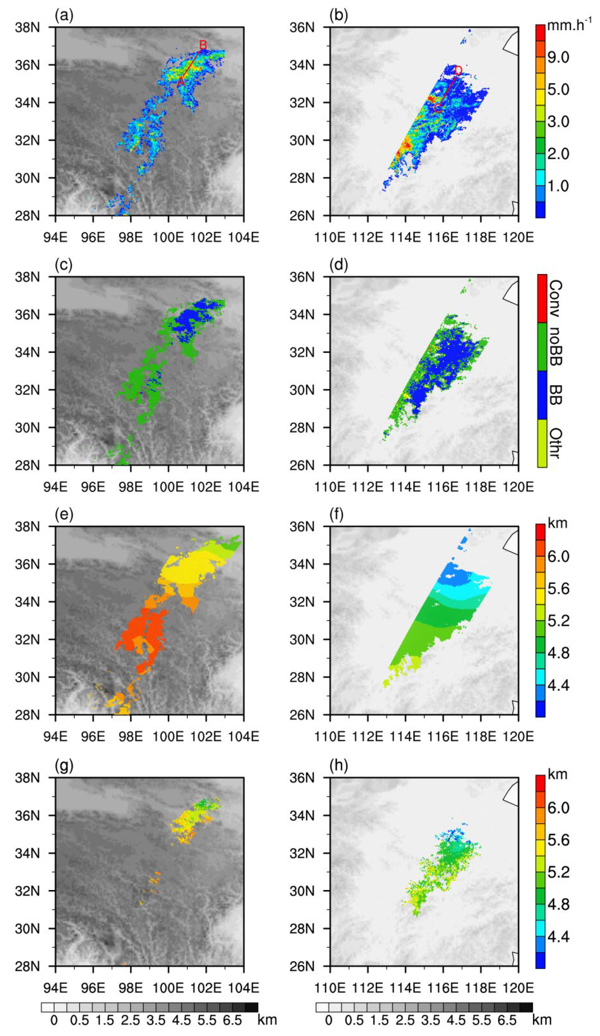
To further understand the differences in precipitation and BB parameters between the two regions, Figure 2 shows two precipitation cases measured by DPR in boreal summer, which are called Case A (occurred in TP) and Case B (occurred in CEC). Case A occurs in the eastern part of TP at an altitude of about 3 to 4 km. The RR in the northern rain belt is larger, ranging from 2 to 5 mm/h, while the RR in the southern rain belt is mostly less than 2 mm/h (Figure 2a). Case B occurs in eastern China with an altitude below 1.5 km. The precipitation area and RR of Case B are larger than those of Case A, with the maximum RR up to 11 mm/h, but there are also many pixels with RR less than 2 mm/h (Figure 2b). The northern rain belt of Case A is dominated by StraP−BB, while the southern rain belt is dominated by StraP−noBB (Figure 2c). Case B is mainly composed of StraP−BB, the area of StraP−noBB is relatively small, and StraP−noBB is mostly distributed in the outer orbit (Figure 2d). The study of Awaka et al. [8] showed that DPR’s ability to detect BB in the inner orbit is obviously stronger than that in the outer orbit. From Figure 2e,f, it can be seen that the FLH in Case A is distributed at 5.2 to 6.2 km, and the FLH gradually increases from the northeast to the southwest of the rain belt. The FLH in Case B is lower than that in Case A, distributed at 4.2 to 5.2 km, and the FLH in the southern part of the rain belt is higher, possibly because of the higher temperature. Figure 2g,h display the distribution of the MLH for StraP−BB, showing that the MLH is mostly distributed at 5.2 to 5.8 km in Case A, which is close to the FLH. The MLH in Case B varies from 4.4 to 5.6 km, which is also close to the FLH. In general, the TP has an obvious lifting effect on FLH, and the latitude distribution of temperature also causes the FLH to be higher in the south and lower in the north, but the MLH is close to the FLH no matter how the FLH changes.
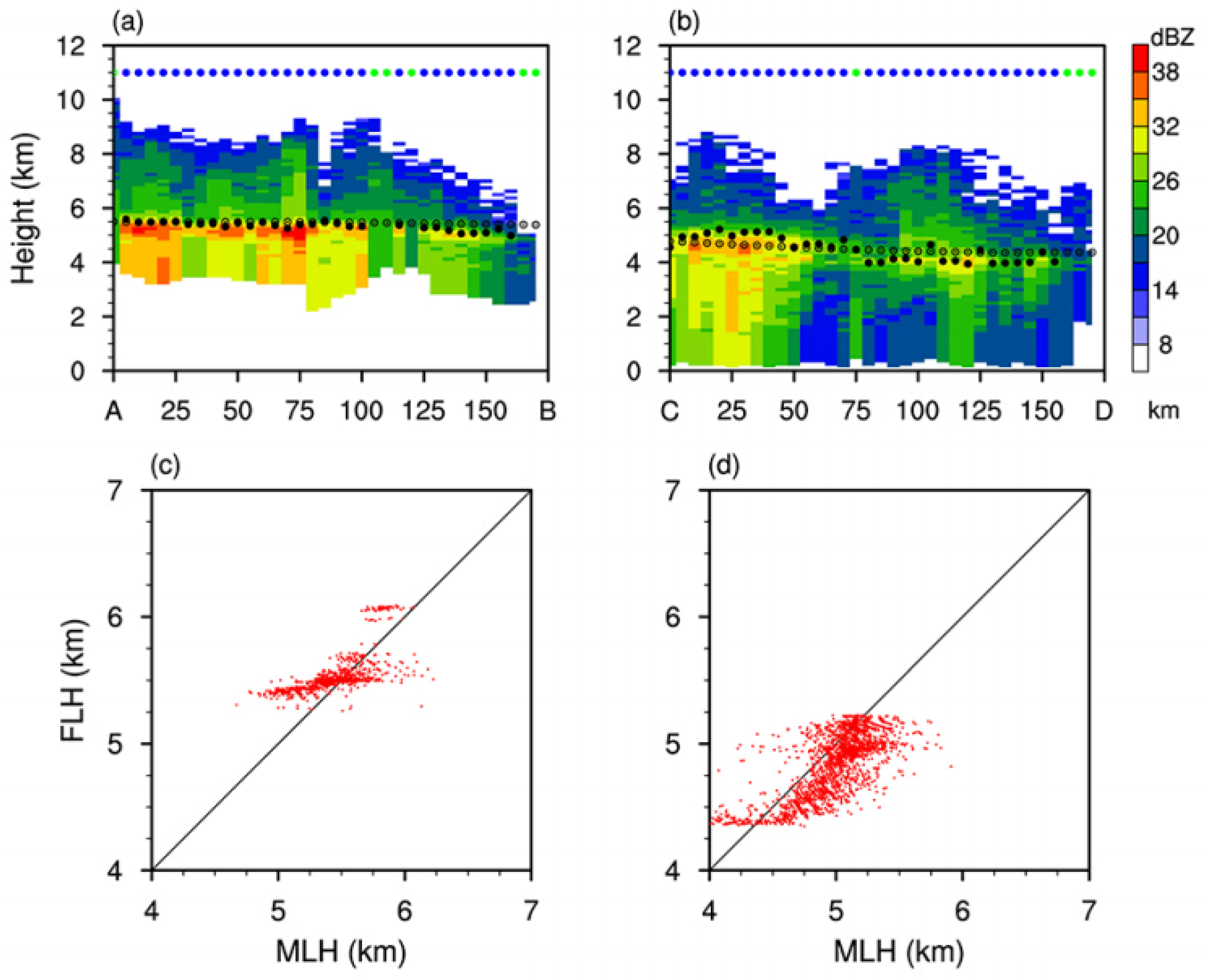
Figure 3a,b show the vertical cross sections of RF along the AB and CD lines. In Figure 2a,b, it can be seen that the two cross sections are mostly composed of StraP−BB, with strong radar echo occurring below the FLH and weaker echo occurring above the FLH. Compared with Case B, Case A shows weaker vertical extension of the echo column, reflecting the compression effect of the TP on rain clusters. In Figure 3a, the FLH is distributed at 5 km, which is either slightly higher than MLH or basically coincides with MLH. The maximum RF distributes slightly lower than the MLH, reaching about 38 dBZ. The FLH in Case B is generally close to 5 km, and the MLH in the strong RF area (left part of Figure 3b) is 100 to 500 m higher than the FLH. This may be because the FLH is provided by reanalysis data and cannot represent the real FLH in the precipitation cloud. The MLH in the weaker RF region (from the middle to the right part of Figure 3b) is about 100 to 500 m lower than the FLH, which basically conforms to the theory of cloud physics. The above explanation indicates there is an error in FLH provided by the reanalysis data; the FLH changes with the updraft inside the cloud and is not a constant value. Figure 3c,d show the scatter plot of the FLH and the MLH for StraP−BB in two cases. The FLH and MLH distribute at 5.2 to 6.2 km and 4.6 to 6.2 km in Case A, as well as 4.2 to 5.2 km and 4 to 6 km in Case B. Case A shows about two out of five precipitation pixels with MLH higher than FLH, while Case B shows about four out of five precipitation pixels with MLH higher than FLH.
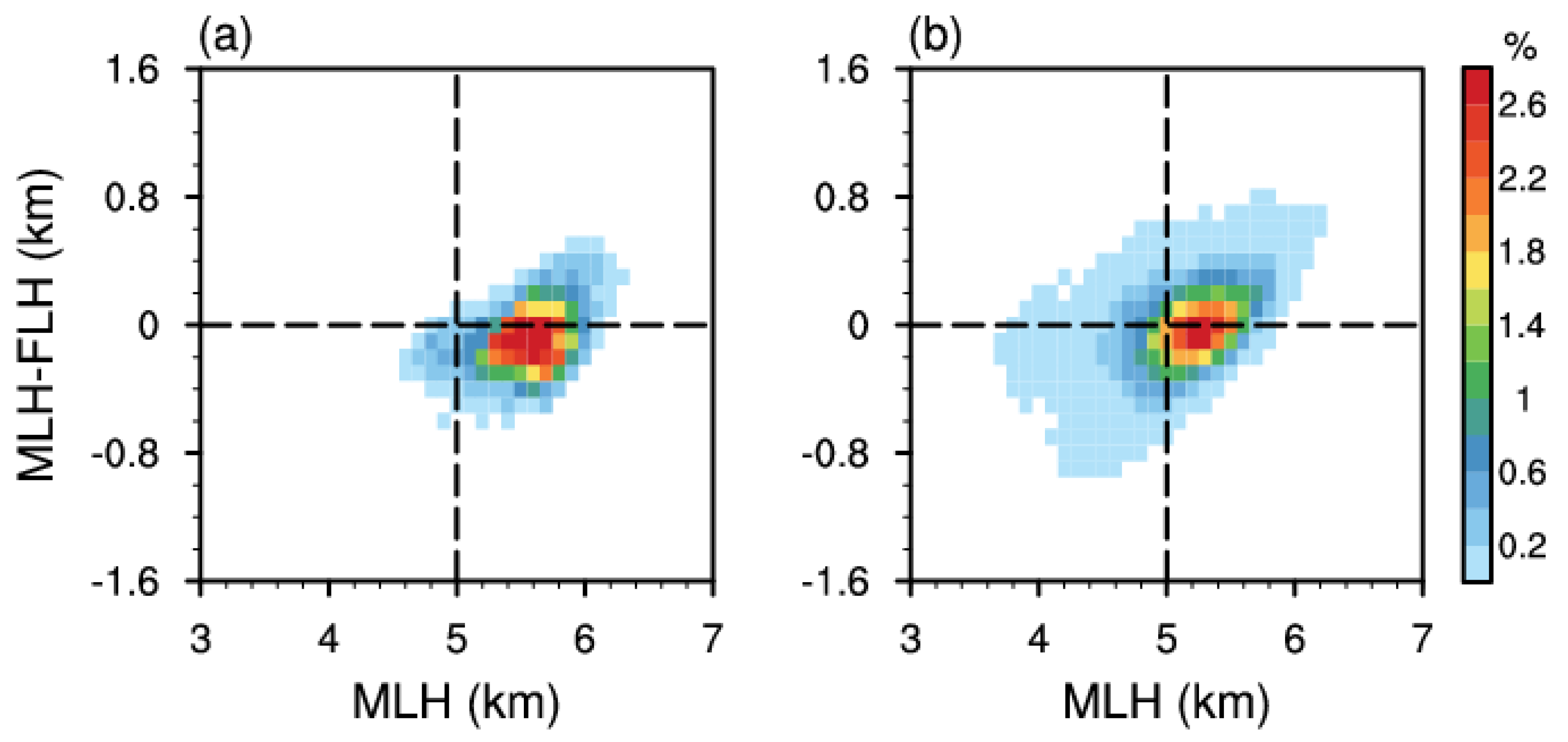
Although the FLH provided by 2ADPR is not completely accurate, it can show us some temperature characteristics inside the precipitation cloud. To explore the relationship between MLH and FLH in more detail, the two-dimensional probability density of MLH and ∆H (MLH−FLH) in summer is presented in Figure 4. As shown in Figure 4a,b, the higher value of MLH is the higher value of ∆H is, indicating the presence of strong warm updrafts, which is consistent with the previous study on the MLH in typhoons by Qiao et al. [40]. The MLH in TP is about 0.5 km higher than that in CEC; reflecting the high terrain of TP will influence the vertical structure of precipitation, and this may also be related to the stronger solar radiation received by the underlying surface of TP [41]. The distribution of MLH (∆H) is wider in CEC (Figure 4b), ranging from 3.6 to 6.2 km (from −1 to 0.8 km), while it is concentrated in TP (Figure 4a), ranging from 4.5 to 6.2 km (from −0.6 to 0.6 km). Previous studies show the vertical motion of the air is weak in TP, and the particles in the precipitation clouds are also small in size [29,39,42]. Therefore, ice particles melt quickly near the FLH, and the variation of MLH(∆H) is small in TP. In CEC, precipitation cloud in summer is relatively deep, so the ice particle size has a larger variation, resulting in significant changes in MLH(∆H).
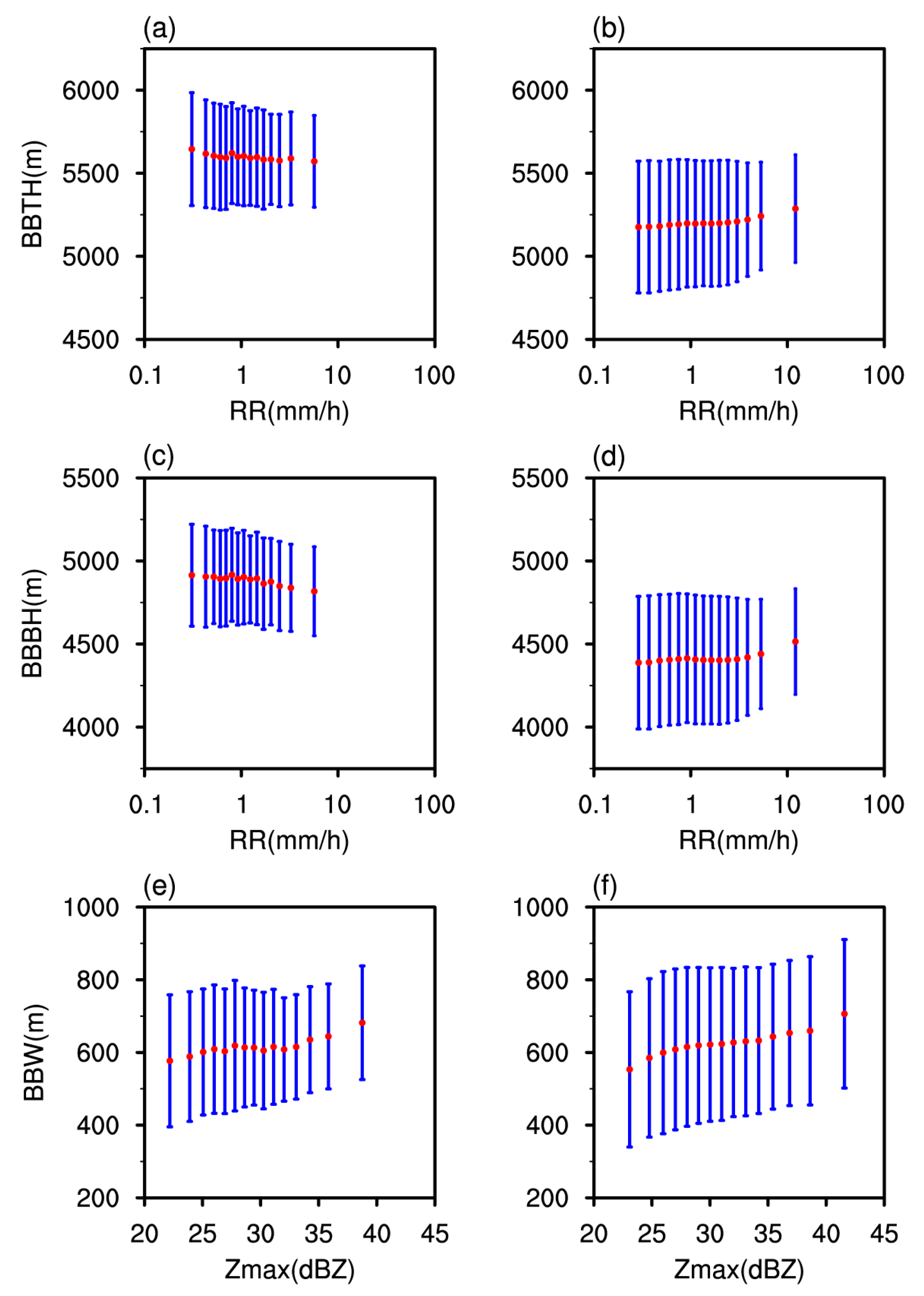
In Figure 5, the relationship between precipitation parameters and BB parameters is presented. From Figure 5a,c, we can see that with the increase in RR, BBTH and BBBH both decrease in TP, which may be caused by the dragging effect of mixed-phase particles. Fabry and Zawadzki [13] considered that the sagging BB may be caused by large ice particles above the FLH, which need more time to melt. Other researchers revealed that the sagging BB is also related to riming, particle density, and relative humidity [4,14,43]. However, BBTH and BBBH slightly increase with the increase in RR in CEC, possibly due to the strong updraft inside the cloud (Figure 5b,d). Moreover, BBTH and BBBH in TP (Top: 5250 to 6000 m, Bottom: 4500 to 5250 m) are higher than that in CEC (Top: 4750 to 5600 m, Bottom: 4000 to 4750 m). In Figure 5e and f, it can be found that the BBW becomes wider with the increase in Zmax. For a given value of Zmax, the variation range of BBW in TP is smaller than that in CEC, which again indicates that the ice particles in TP are smaller in size and melt faster near the FLH.

3.2. Characteristics of Vertical Structure for Different Types of Precipitation

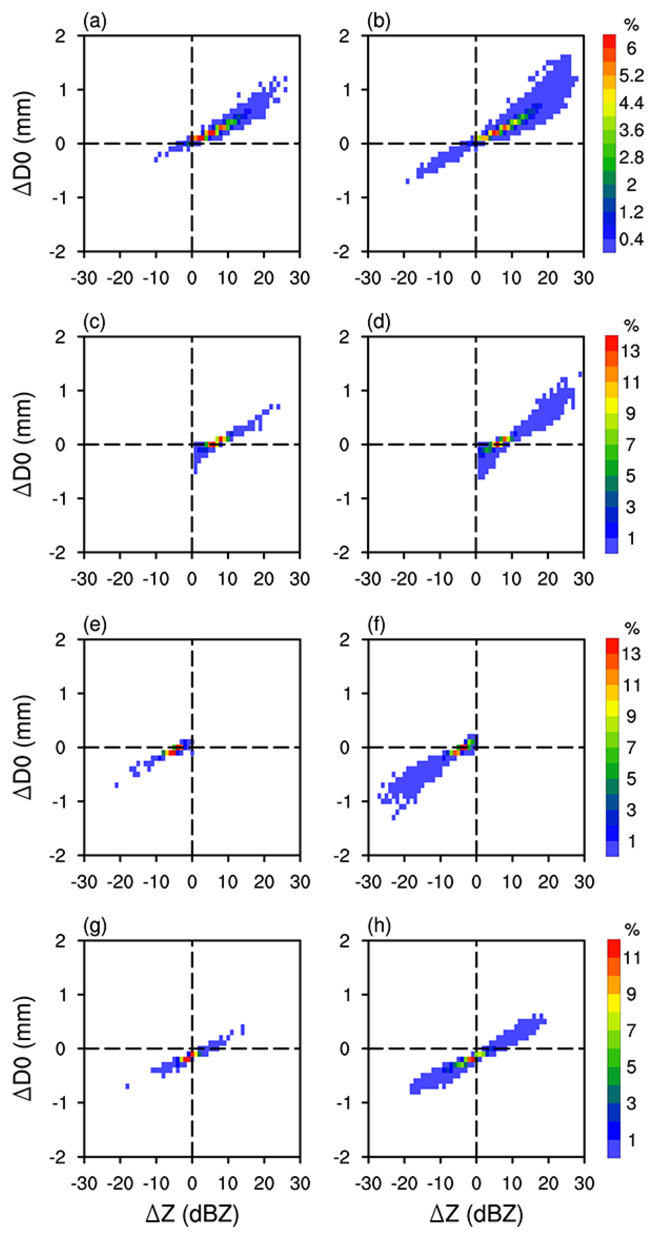
BB is an important symbol of the ice–water transition zone in stratiform precipitation. To explore the growth mechanism of ice particles, mixed phase particles, and liquid particles in StraP–BB, the changes in D0 and Z between the two layers of STH and BBTH, BBTH and BBPH, BBPH and BBBH, and BBBH and NSH are used to describe the microphysical process. Compared to CEC, the variations of D0 and Z at different precipitation phases are smaller in TP, possibly because the precipitation in summer TP is weaker. From ETH to BBTH (Figure 6a,b), the D0 of ice particles gradually increases (∆D0 > 0), causing an increase in Z (∆Z > 0). At this stage, small ice and snow particles grow mainly through riming, aggregation, and vapor deposition, but there are very small proportions of samples with negative ∆Z and ∆D0 in CEC, which may be due to the sublimation and breakup of small particles. In the mixed1 region (Figure 6c,d), the ice particles start to melt and the dielectric constant increases rapidly; the stickier particles are more likely to coalesce as well, resulting in the positive Z and D0. In the mixed2 region (Figure 6e,f), the ice particles have completely melted into large raindrops, which will not last long and further break into small raindrops, resulting in a rapid decrease in Z. At the stage of liquid precipitation (Figure 6g,h), some particles breakup or evaporate (∆D0 < 0, ∆Z < 0), while some particles grow continuously through collision and coalescence effects (∆D0 > 0, ∆Z > 0).
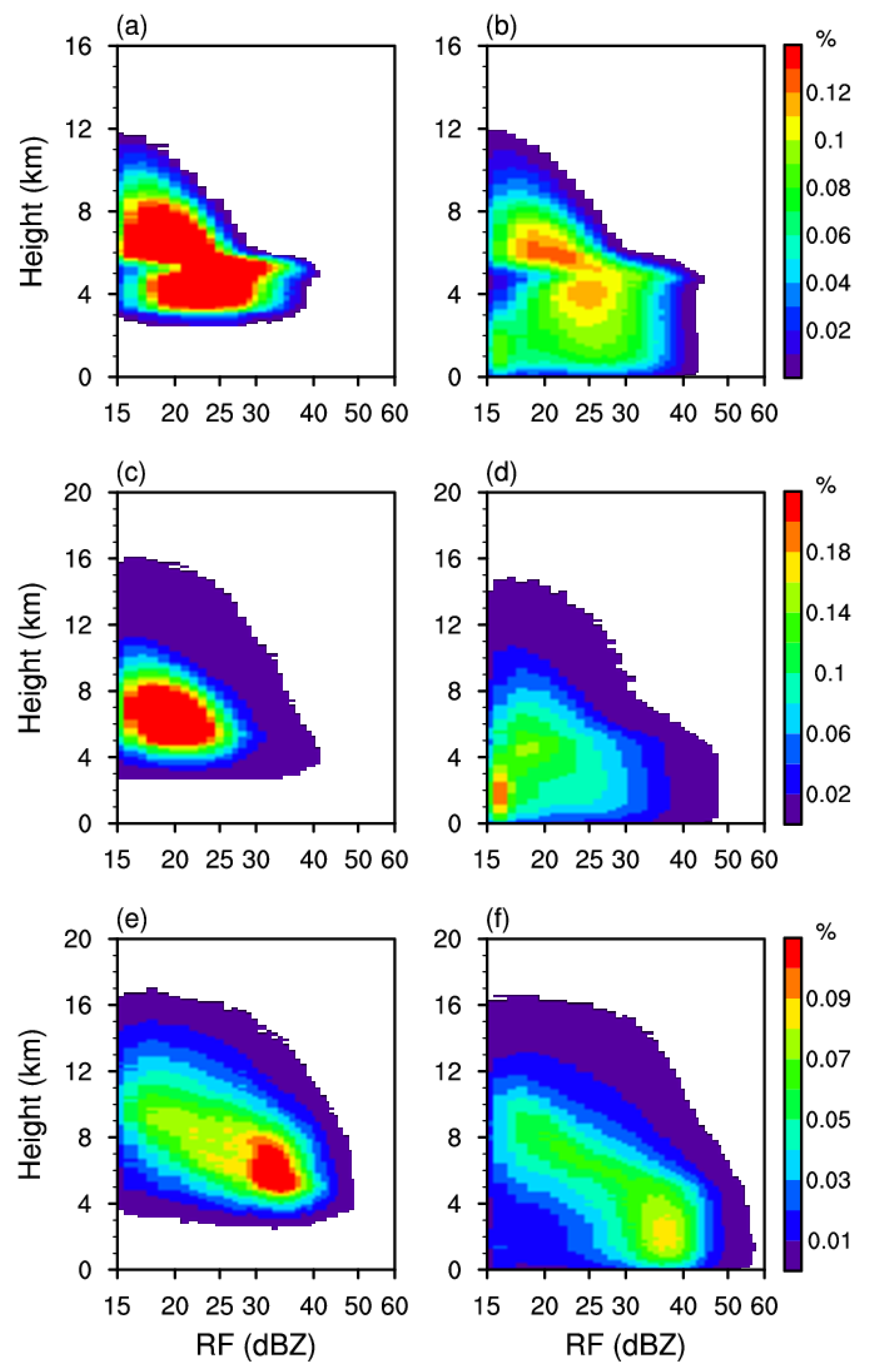
To further understand the vertical structural characteristics of StraP−BB, we calculate the distribution of probability density of RF with height (DPDH). For comparison purposes, the DPDH for StraP−noBB and ConvP are also calculated. As shown in Figure 7, the vertical extension of the RF is weaker in TP, reflecting the compression effect of the TP on rain clusters. From Figure 7a,b, we can see that the vertical structure of StraP−BB is similar in TP and CEC; the clear BB can be seen near the altitude of 5 km, but the BBH in TP is higher (5.5 km), and the BBH in CEC is lower (5 km). Figure 7c,d show the ETH of StraP−noBB is higher than that of StraP−BB, and there is a significant difference in DPDH of StraP−noBB between TP and CEC. The high-value areas of DPDH in TP are more concentrated, with RF distributed in 15 to 25 dBZ at the height of 4 to 8 km and RF in CEC mainly distributed in 15 to 30 dBZ at the height of 0 to 8 km. Moreover, the vertical structure of StraP−noBB in Figure 7c is similar to that of weak convective precipitation in TP [39], indicating that StraP−noBB in TP may be the weak ConvP. Figure 7e,f indicate that the ConvP classified by DPR are very deep, with the maximum ETH up to 16 km and a high proportion of strong RF near the surface (30–40 dBZ); RF in CEC can reach up to 50 dBZ near the surface. Overall, the maximum RF of StraP−BB appears at 5 km, while the maximum RF of StraP−noBB and ConvP appears near the ground. The vertical structure of these three types of precipitation shows quite different characteristics.
The mean profiles of DSD for different types of precipitation are shown in Figure 8. The mean ranges of D0 for StraP−BB and StraP−noBB are 0.95 to 1.3 mm and 1.1 to 1.25 mm, respectively, and the mean range of dBN0 is about 30.5 to 34.5 and 30 to 33.5. The DSD of ConvP varies most in the vertical direction, with mean D0 and dBN0 distributing at 1.45 to 1.8 mm and 22 to 34. From ETH to the ground, the D0 of StraP−BB first increases and then decreases, but the D0 of StraP−noBB and ConvP first decrease and then increase. As shown in Figure 8a,b, the D0 of StraP−BB and StraP−noBB in TP are smaller than that in CEC, especially for StraP−BB (about 0.1 mm smaller than CEC). For ConvP (Figure 8c), at the height of 6 to 11 km, the mean D0 in TP is about 0.1 mm larger than that in CEC, while at the height of 0 to 6 km and 11 to 18 km, the mean D0 is larger in CEC. In addition, the D0 of StraP−BB is slightly larger (smaller) than that of StraP−noBB below (above) 5 km but is obviously smaller than that of ConvP at any height. From Figure 8d–f, we can see that the dBN0 in TP is obviously larger than that in CEC, and the dBN0 of ConvP decreases faster with height than that of StraP−BB and StraP−noBB.
To understand the vertical distribution of atmospheric parameters, Figure 9 shows the mean vertical profiles of vertical velocity, temperature, and specific humidity for different types of precipitation. In TP (Figure 9a), the vertical velocity of StraP−BB (ConvP) reaches the maximum value of about −0.23 Pa/s (−0.22 Pa/s) at 4.5 km (9 km). StraP-noBB has the weakest upward motion in the vertical direction, and its profile shape is similar to that of ConvP, which again indicates that the StraP−noBB classified by DPR is actually weak ConvP. In CEC (Figure 9b), the maximum values of vertical velocity profiles occur at 6 to 6.5 km. ConvP has the maximum value between 0 and 4 km and above 10 km, and StraP−BB has the maximum value between 4 and 10 km. In general, the vertical velocity of these three types of precipitation is larger in CEC than in TP, and the height of maximum vertical velocity of ConvP and StraP−noBB in the TP is higher than that in the CEC. From Figure 10c,d, it can be found that the temperature of ConvP near the surface is slightly higher than that of StraP−BB and StraP−noBB. In Figure 10f, we can see that near the land surface in CEC, the maximum value of specific humidity for ConvP is up to 18 g/kg, but StraP−BB and StraP−noBB have lower specific humidity, about 16 g/kg. Specific humidity at the near surface in TP (Figure 10e) is much lower than that in CEC; ConvP (9 g/kg) and StraP−BB (9 g/kg) have higher values than that of Stra−noBB (8 g/kg).
Figure 10 shows the difference between ConvP and StraP−BB, StraP−noBB and StraP–BB in Figure 9. In TP (Figure 10a), StraP–BB has the maximum value of vertical velocity below 7 km; the biggest difference between ConvP and StraP−BB occurred at the surface. At a height of 7 to 15 km, ConvP has the maximum value of vertical velocity. In CEC (Figure 10b), the biggest difference between ConvP and StraP−BB below 4 km is about −0.1 Pa/s, indicating that in the lower troposphere, the upward motion of ConvP is significantly stronger than that of StraP−BB. Figure 10c shows that below 6 km in TP, the temperature of ConvP is higher than that of StraP−BB (with a maximum difference of 2.6 K), but at 6 to 12 km, StraP−BB has a higher temperature. In CEC (Figure 10d), the atmospheric temperature of ConvP is 2.5 K higher than that of StraP–BB near the surface, and the temperature difference between ConvP and StraP−BB decreases with the increase in altitude (below 7 km), implying the uneven heating of the land surface, and higher land surface temperatures (LST) are more likely to trigger convection. From Figure 10e, we can see that in TP, although ConvP has the highest LST, its specific humidity is almost lower than StraP−BB in the vertical direction. However, in CEC (Figure 10f), the specific humidity of ConvP is higher than StraP−BB below 3.5 km, with the maximum difference reaching up to 2 g/kg. StraP−BB has the highest specific humidity above 3.5 km.

3.3. The Influence of BB on Passive Microwave Observations

Since the BB is caused by the melting of ice particles, the composition of hydrometeors near the FLH may not be a single phase. To analyze the influence of BB on passive microwave signal, the relationship between the mean T B V (PD) and RR of StraP−BB and StraP−noBB is compared as follows:
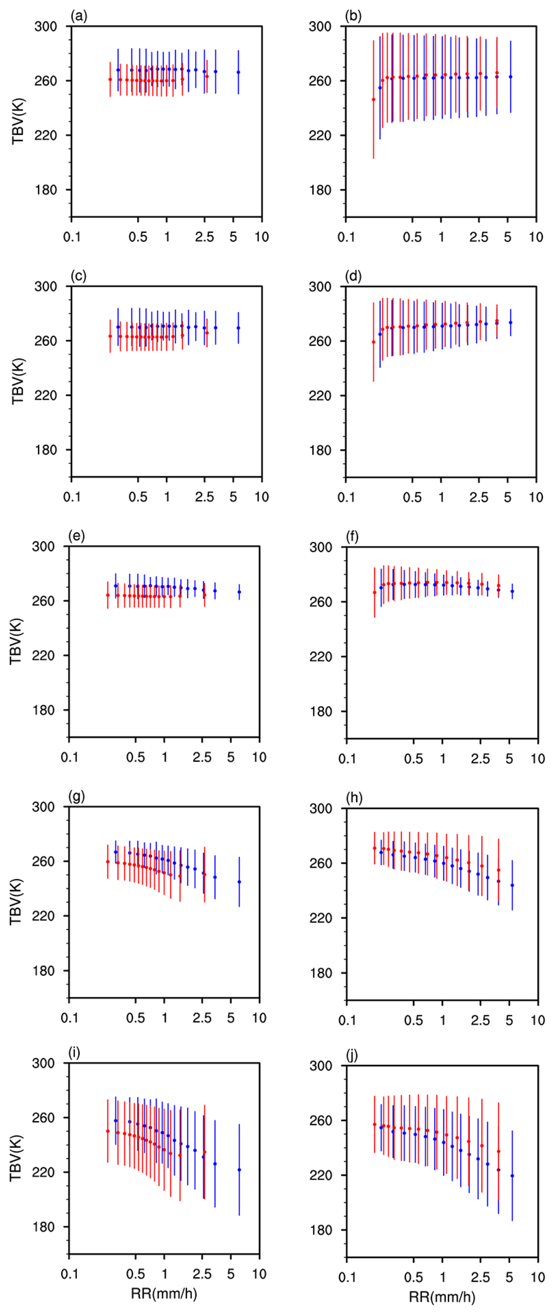
At 10.65 GHZ, 18.7 GHZ, and 36.5 GHZ (Figure 11b,d,f), the T B V in BB and noBB cases is relatively close in CEC and slightly increases with the increase in RR. At 89 GHZ and 166 GHZ (Figure 11h,j), T B V decreases with the increase in RR, and T B V are obvious lower when BB exists; this may be because there are more ice and mixed particles in StraP−BB, thus enhancing the scatter effect, which is consistent with the previous study [27]. The decrease in T B V at 166 GHZ is slightly greater than that at 89 GHZ. In TP, the T B V at 10.65 GHZ, 18.7 GHZ, and 36.5 GHZ hardly change with RR (Figure 11a,c,e), indicating that emission and scattering compete with each other. The T B V of five channels in BB cases are always higher than that in noBB cases, which is different from that in CEC. This may be because the intensity of StraP−BB in TP is weak, so its precipitation cloud contains fewer frozen particles than that of StraP−noBB.
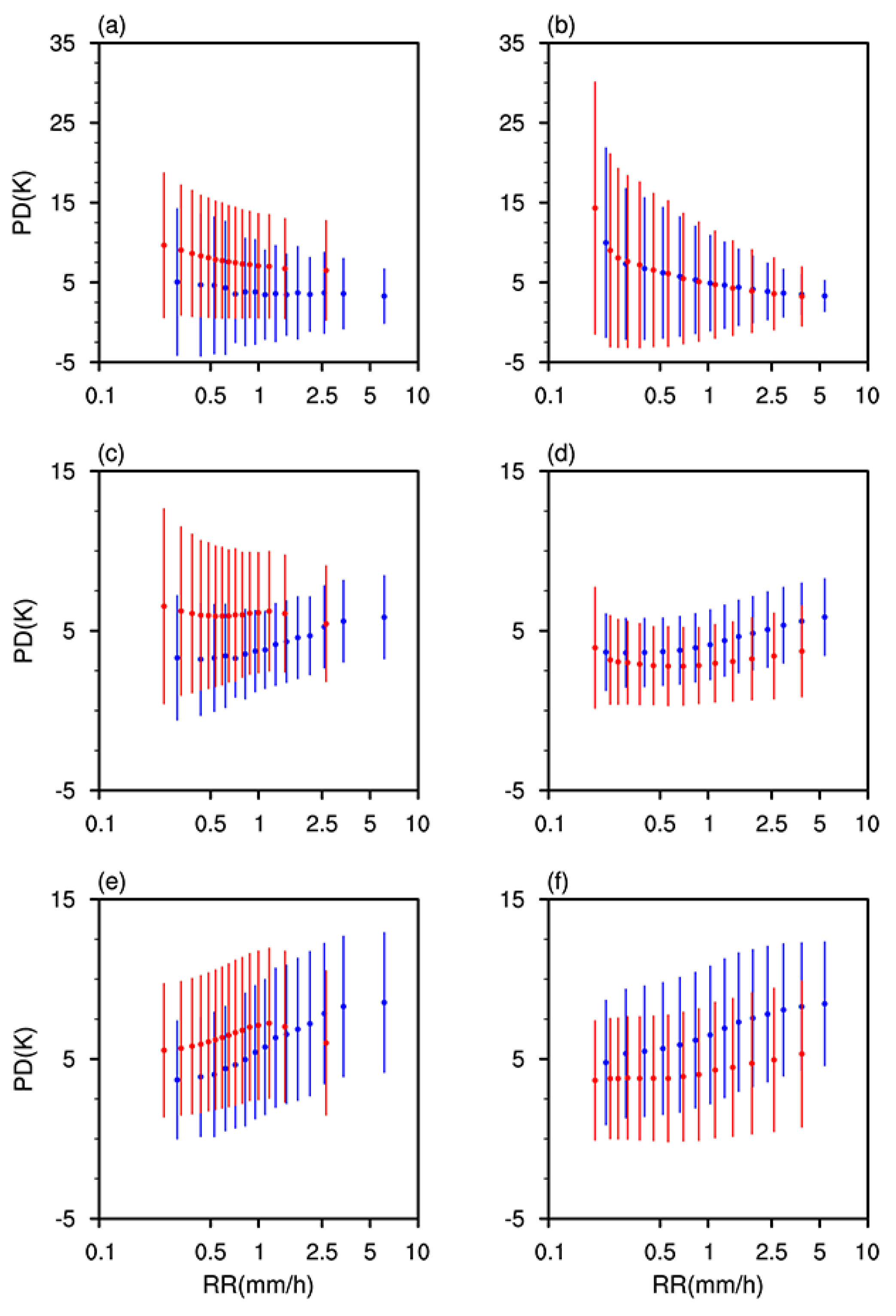
Figure 12 shows the relationship between PD and RR for StraP−BB and StraP−noBB at 36.5 GHZ, 89 GHZ, and 166 GHZ. In CEC, PD mostly distributes at −5 to 25 K. At 36.5 GHZ, PD does not show the obvious difference between StraP−BB and StraP−noBB and gradually decreases with the increase in RR (Figure 12b). At 89 GHZ and 166 GHZ, the PD hardly changes with RR for StraP−noBB, while PD increases with RR for StraP-BB (Figure 12d,f). The difference in PD between StraP−BB and Stra−noBB increases with the increase in RR, reflecting an increase in the number of ice particles, which also indicates that PD is mainly generated by the hydrometeors. The PD in TP is lower than that in CEC, mostly distributed at −5 to 15 K, and the PD of StraP−BB is always lower than that of Stra−noBB, which is contrary to CEC (Figure 12a,c,e).

4. Conclusions

By using DPR, GMI, and ERA5 data during 2014–2021 from June to August, we first analyze the characteristics of precipitation parameters and BB parameters in TP and CEC, and then the differences in vertical structure, microphysical process, and atmospheric characteristics for StraP−BB, StraP−noBB, and ConvP are compared. At last, the impact of BB on passive microwave signals is presented. The main conclusions are as follows:
(1) TP has an obvious lifting effect on FLH, and the latitude distribution of temperature also causes the FLH to be higher in the south and lower in the north. The MLH is sometimes lower than the FLH, which is contradictory to the theory of cloud physics, indicating the FLH provided by the reanalysis data is not completely accurate. The MLH distributes at 4.5 to 6.2 km in TP, while it distributes at 3.6 to 6.2 km in CEC. The variation range of MLH is smaller in TP, and the MLH in TP is about 0.5 km higher than that in CEC.
(2) With the increase in RR, BBTH and BBBH both decrease in TP, which may be caused by the dragging effect of mixed-phase particles. However, BBTH and BBBH slightly increase with the increasing RR in CEC, possibly attributed to the strong updraft inside the cloud. The BBW becomes wider with the increase in Zmax. For a given value of Zmax, the variation range of BBW in TP is smaller than that in CEC, which indicates that the ice particles in TP are smaller in size and melt faster near the FLH.
(3) The vertical structure and microphysical characteristics of StraP−BB, StraP−noBB, and ConvP are quite different. The maximum reflectivity factor and particle diameter of StraP−BB appear at 5 km, while the maximum reflectivity factors of StraP−noBB and ConvP appear near the ground. The particle diameter first decreases and then increases from the cloud top to the ground. The particle diameter (concentration) of StraP−BB and StraP−noBB in TP is smaller (larger) than that in CEC.
(4) The vertical velocity of three types of precipitation is larger in CEC than in TP, and the height of maximum vertical velocity of ConvP and StraP−noBB in TP is higher than that in CEC. The LST of ConvP in TP (CEC) is 2.6 °C (2.5 °C) higher than that of StraP−BB, indicating higher LST are more likely to trigger convection. In CEC, the specific humidity of ConvP is the largest below 3.5 km, and the specific humidity of StraP−BB is the largest above 3.5 km. In TP, the specific humidity of ConvP is almost lower than that of StraP−BB in the vertical direction.
(5) In CEC, T B V values at 89 GHZ and 166 GHZ are obvious lower when BB exists; this may be because there are more frozen particles in StraP−BB, thus enhancing the scatter effect. In addition, the difference in PD between StraP−BB and StraP−noBB increases with the increase in RR, indicating that PD is mainly generated by the hydrometeors. In TP, the T B V values in BB cases are always higher than that in noBB cases; this may be because the intensity of StraP−BB in TP is weak, so its cloud contains fewer frozen particles than that of StraP−noBB.

Author Contributions

Conceptualization, L.Y. and Y.F.; methodology, L.Y. and N.S.; software, L.Y.; validation, L.Y., N.S. and Y.F.; formal analysis, L.Y.; investigation, L.Y. and Y.F.; writing—original draft preparation, L.Y.; writing—review and editing, L.Y.; visualization, L.Y.; supervision, Y.F., M.M., C.C., B.W. and X.W.; project administration, Y.F. and C.C. All authors have read and agreed to the published version of the manuscript.

Funding

This research was funded by the National Natural Science Foundation of China, grant number 42230612 and 42275140.

Data Availability Statement

GPM DPR data used in this study are archived at https://disc.gsfc.nasa.gov/datasets/GPM_2ADPR_07/summary, accessed on 15 December 2021. GPM GMI data are archived at https://disc.gsfc.nasa.gov/datasets/GPM_1CGPMGMI_R_07/summary?keywords=1C-R, accessecd on 10 May 2022. ERA5 data can be downloaded at: https://cds.climate.copernicus.eu/datasets/reanalysis-era5-pressure-levels?tab=download, accessed on 14 June 2020.

Conflicts of Interest

The authors declare no conflicts of interest.

References

  1. Houze, R.; Robert, A. Cloud Dynamics; Academic Press: Cambridge, MA, USA, 1993; p. 577. [Google Scholar]
  2. Williams, C.R.; Ecklund, W.L.; Gage, K.S. Classification of precipitating clouds in the tropics using 915 MHz wind profilers. J. Atmos. Ocean. Technol. 1995, 12, 996–1012. [Google Scholar] [CrossRef]
  3. Glickman, T.S. Glossary of Meteorology, 2nd ed.; American Meteorological Society: Boston, MA, USA, 2000; 855p. [Google Scholar]
  4. Zawadzki, I.; Szyrmer, W.; Bell, C.; Fabry, F. Modeling of the melting layer. Part III: The density effect. J. Atmos. Sci. 2005, 62, 3705–3723. [Google Scholar] [CrossRef]
  5. Konwar, M.; Maheskumar, R.S.; Das, S.K.; Morwal, S.B. Nature of light rain during presence and absence of bright band. J. Earth Syst. Sci. 2012, 121, 947–961. [Google Scholar] [CrossRef]
  6. Thurai, M.; Gatlin, P.N.; Bringi, V.N. Separating stratiform and convective rain types based on the drop size distribution characteristics using 2D video disdrometer data. Atmos. Res. 2016, 169, 416–423. [Google Scholar] [CrossRef]
  7. Awaka, J.; Iguchi, T.; Kumagai, H.; Okamoto, K. Rain Type Classification algorithm for TRMM precipitation radar. In Proceedings of the IGARSS’97—1997 IEEE International Geoscience and Remote Sensing Symposium, Singapore, 3–8 August 1997; Volume 4, pp. 1633–1635. [Google Scholar]
  8. Awaka, J.; Le, M.; Chandrasekar, V.; Yoshida, N.; Higashiuwatoko, T.; Kubota, T.; Iguchi, T. Rain Type Classification Algorithm Module for GPM Dual-Frequency Precipitation Radar. J. Atmos. Ocean. Technol. 2016, 33, 1887–1898. [Google Scholar] [CrossRef]
  9. Smith, C.J. The reduction of errors caused by bright bands in quantitative rainfall measurements made using radar. J. Atmos. Ocean. Technol. 1986, 3, 129–141. [Google Scholar] [CrossRef]
  10. Qi, Y.C.; Zhang, J.; Zhang, P.F.; Cao, Q. VPR correction of bright band effects in radar QPEs using polarimetric radar observations. J. Geophys. Res. 2013, 118, 3627–3633. [Google Scholar] [CrossRef]
  11. Hall, W.; Rico-Ramirez, M.A.; Kramer, S. Classification and correction of the bright band using an operational C-band polarimetric radar. J. Hydrometeorol. 2015, 531, 248–258. [Google Scholar] [CrossRef]
  12. Cao, Y.; Su, D.B.; Fan, X.G.; Chen, H.B. Evaluating the algorithm for correction of the bright band effects in QPEs with S-, C- and X-Band dual-polarized radars. Adv. Atmos. Sci. 2019, 36, 41–54. [Google Scholar] [CrossRef]
  13. Fabry, F.; Zawadzki, I. Long-term radar observations of the melting layer of precipitation and their interpretation. J. Atmos. Sci. 1995, 52, 838–851. [Google Scholar] [CrossRef]
  14. Li, H.; Moisseev, D. Melting layer attenuation at Ka- and W-bands as derived from multi-frequency radar Doppler spectra observations. J. Geophys. Res. Atmos. 2019, 124, 9520–9533. [Google Scholar] [CrossRef]
  15. Zafar, B.; Chandrasekar, V. Global study of bright band structure as observed from spaceborne precipitation radar. Microw. Remote Sens. Atmos. Environ. 2004, 5654, 214–221. [Google Scholar]
  16. Thurai, M.; Iguchi, T. Rain height information from TRMM precipitation radar. Electron. Lett. 2000, 36, 1059–1061. [Google Scholar] [CrossRef]
  17. Thurai, M.; Iguchi, T.; Kozu, T.; Eastment, J.D.; Wilson, C.L.; Ong, J.T. Radar observations in Singapore and their implications for the TRMM precipitation radar retrieval algorithms. Radio Sci. 2003, 38, 7–11. [Google Scholar] [CrossRef]
  18. Das, S.; Maitra, A.; Shukla, A.K. Melting layer characteristics at different climatic conditions in the Indian region: Ground based measurements and satellite observations. Atmos. Res. 2011, 101, 78–83. [Google Scholar] [CrossRef]
  19. Okamoto, K.; Sasaki, H.; Deguchi, E.; Thurai, M. Bright Band height statistics observed by the TRMM precipitation radar. In Proceedings of the 2nd TRMM International Science Conference, Nara, Japan, 6–10 September 2004. [Google Scholar]
  20. Sumesh, R.K.; Resmi, E.A.; Unnikrishnan, C.K.; Jash, D.; Sreekanth, T.S.; Resmi, M.M.; Rajeevan, K.; Nita, S.; Ramachandran, K.K. Microphysical aspects of tropical rainfall during Bright Band events at mid and high-altitude regions over Southern Western Ghats, India. Atmos. Res. 2019, 227, 178–197. [Google Scholar] [CrossRef]
  21. Martner, B.; Yuter, S.; White, A.B.; Matrosov, S.; Kingsmill, D.; Ralph, F. Raindrop Size Distributions and Rain Characteristics in California Coastal Rainfall for Periods with and without a Radar Bright Band. J. Hydrometeorol. 2008, 9, 408–425. [Google Scholar] [CrossRef]
  22. Heymsfield, A.J.; Bansemer, A.; Poellot, M.R.; Wood, N. Observations of ice microphysics through the melting layer. J. Atmos. Sci. 2015, 72, 2902–2928. [Google Scholar] [CrossRef]
  23. Sun, N.; Lu, G.P.; Fu, Y.F. Microphysical characteristics of precipitation within convective overshooting over East China observed by GPM DPR and ERA5. Atmos. Chem. Phys. 2024, 24, 7123–7135. [Google Scholar] [CrossRef]
  24. Olson, W.S.; Bauer, P.; Kummerow, C.D.; Hong, Y.; Tao, W.K. A melting-layer model for passive/active microwave remote sensing applications. Part II: Simulation of TRMM observations. J. Appl. Meteorol. 2001, 40, 1164–1179. [Google Scholar] [CrossRef]
  25. Johnson, B.T.; Olson, W.S.; Skofronick-Jackson, G. The microwave properties of simulated melting precipitation particles: Sensitivity to initial melting. Atmos. Meas. Tech. 2016, 9, 9–21. [Google Scholar] [CrossRef] [PubMed]
  26. Battaglia, A.; Kummerow, C.; Shin, D.B.; Williams, C. Constraining microwave brightness temperatures by radar bright band observations. J. Atmos. Oceanic Technol. 2003, 20, 856–871. [Google Scholar] [CrossRef]
  27. Galligani, V.S.; Prigent, C.; Defer, E.; Jimenez, C.; Eriksson, P. The impact of the melting layer on the passive microwave cloud scattering signal observed from satellites: A study using TRMM microwave passive and active measurements. J. Geophys. Res. Atmos. 2013, 118, 5667–5678. [Google Scholar] [CrossRef]
  28. Li, J.; Lu, C.; Chen, J.; Zhou, X.; Yang, K.; Li, J.; Wu, X.; Xu, X.; Wu, S.; Hu, R.; et al. The influence of complex terrain on cloud and precipitation on the foot and slope of the southeastern Tibetan Plateau. Clim. Dyn. 2024, 62, 3143–3163. [Google Scholar] [CrossRef]
  29. Yan, Y.F.; Liu, Y.M. Vertical structures of convective and stratiform clouds in boreal summer over the Tibetan Plateau and its neighboring regions. Adv. Atmos. Sci. 2019, 36, 1089–1102. [Google Scholar] [CrossRef]
  30. Kukulies, J.; Chen, D.; Wang, M. Temporal and spatial variations of convection, clouds and precipitation over the Tibetan Plateau from recent satellite observations. Part II: Precipitation climatology derived from global precipitation measurement mission. Int. J. Climatol. 2020, 40, 4858–4875. [Google Scholar] [CrossRef]
  31. Iguchi, T.; Seto, S.; Meneghini, R.; Yoshida, N.; Awaka, J.; Le, M.; Chandrasekar, V.; Brodzik, S.; Kubota, T. GPM/DPR Level-2 Algorithm Theoretical Basis Document; NASA Goddard Space Flight Center: Greenbelt, MD, USA, 2018. [Google Scholar]
  32. Le, M.; Chandrasekar, V. Precipitation type classification method for Dual-Frequency Precipitation Radar (DPR) onboard the GPM. IEEE Trans. Geosci. Remote Sens. 2013, 51, 1784–1790. [Google Scholar] [CrossRef]
  33. Gong, J.; Wu, D.L. Microphysical Properties of Frozen Particles Inferred from Global Precipitation Measurement (GPM) Microwave Imager (GMI) Polarimetric Measurements. Atmos. Chem. Phys. 2017, 17, 2741–2757. [Google Scholar] [CrossRef]
  34. Gong, J.; Zeng, X.; Wu, D.L.; Munchak, S.J.; Li, X.; Kneifel, S.; Liao, L.; Barahona, D. Linkage among Ice Crystal Microphysics, 480 Mesoscale Dynamics and Cloud and Precipitation Structures Revealed by Collocated Microwave Radiometer and Multi-frequency Radar Observations. Atmos. Chem. Phys. 2020, 20, 12633–12653. [Google Scholar] [CrossRef]
  35. Hoffmann, L.; Günther, G.; Li, D.; Stein, O.; Wu, X.; Griessbach, S.; Heng, Y.; Konopka, P.; Müller, R.; Vogel, B.; et al. From ERA-interim to ERA5: The considerable impact of ECMWF’s next-generation reanalysis on Lagrangian transport simulations. Atmos. Chem. Phys. 2019, 19, 3097–3124. [Google Scholar] [CrossRef]
  36. Xian, T.; Homeyer, C.R. Global tropopause altitudes in radiosondes and reanalyses. Atmos. Chem. Phys. 2019, 19, 5661–5678. [Google Scholar] [CrossRef]
  37. Hersbach, H.; Bell, B.; Berrisford, P.; Hirahara, S.; Horányi, A.; Muñoz-Sabater, J.; Nicolas, J.; Peubey, C.; Radu, R.; Schepers, D.; et al. The ERA5 global reanalysis. Q. J. R. Meteorol. Soc. 2020, 146, 1999–2049. [Google Scholar] [CrossRef]
  38. Fu, Y.F.; Liu, G.S. Possible misidentification of rain type by TRMM PR over Tibetan Plateau. J. App. Meteor. 2007, 46, 667–672. [Google Scholar] [CrossRef]
  39. Fu, Y.F.; Yang, L.; Zhang, P.; Gu, S.Y.; Chen, L.; Sun, N. A New Algorithm of Rain Type Classification for GPM Dual-Frequency Precipitation Radar in Summer Tibetan Plateau. Adv. Atmos. Sci. 2024, in press. [Google Scholar] [CrossRef]
  40. Qiao, J.Q.; Ai, W.H.; Hu, X.; Hu, S.S.; Du, X.Y. Characteristics of Melting Layer in Cyclones Over the Western North Pacific Detected by the GPM Dual-Frequency Precipitation Radar. Earth Space Sci. 2022, 9, e2021EA001967. [Google Scholar] [CrossRef]
  41. Che, J.H.; Zhao, P. Characteristics of the summer atmospheric boundary layer height over the Tibetan Plateau and influential factors. Atmos. Chem. Phys. 2021, 21, 5253–5268. [Google Scholar] [CrossRef]
  42. Yan, Y.F.; Liu, Y.M.; Lu, J.H. Cloud vertical structure, precipitation, and cloud radiative effects over Tibetan Plateau and its neighboring regions. J. Geophys. Res. Atmos. 2016, 121, 5864–5877. [Google Scholar] [CrossRef]
  43. Carlin, J.T.; Ryzhkov, A.V. Estimation of melting-layer cooling rate from dual-polarization radar: Spectral bin model simulations. J. Appl. Meteorol. Clim. 2019, 58, 1485–1508. [Google Scholar] [CrossRef]
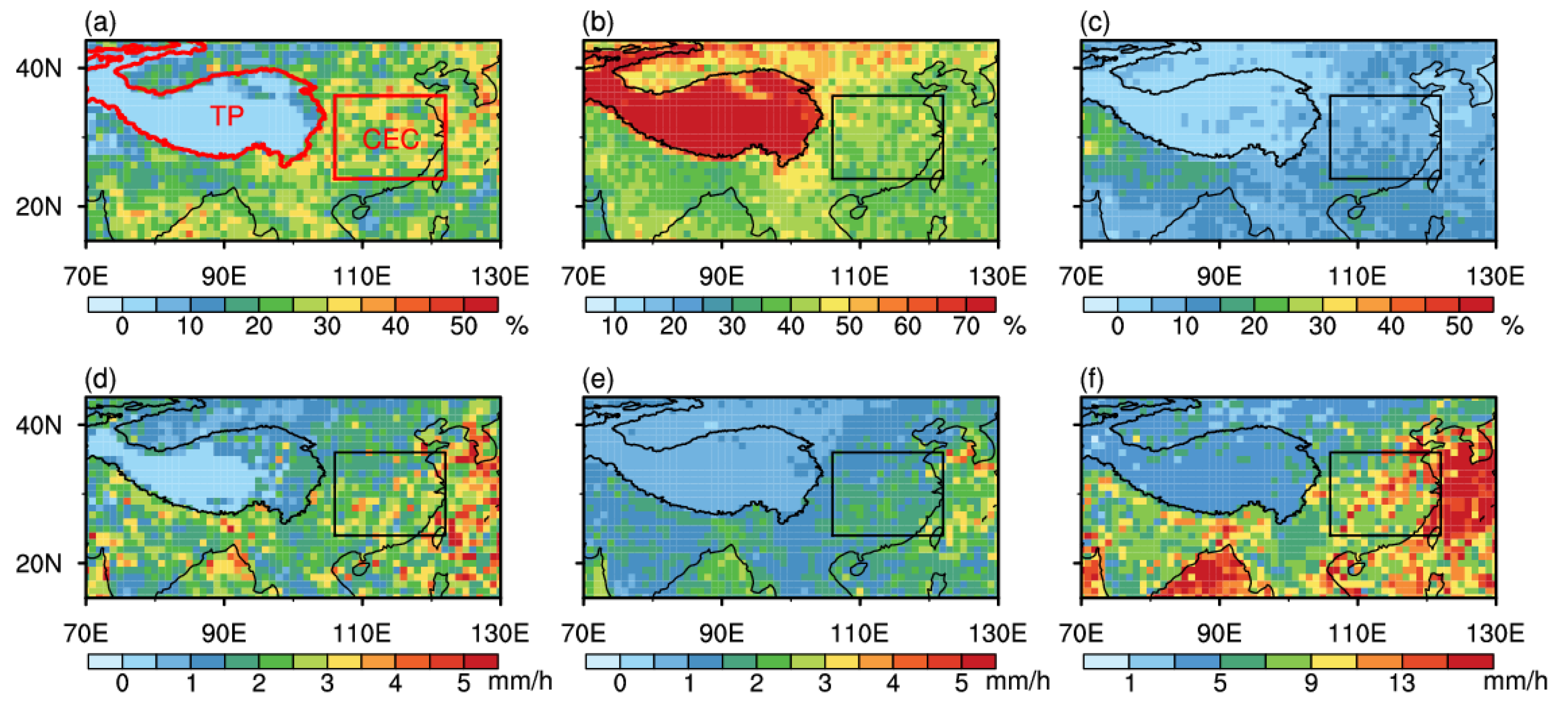
Figure 1. Horizontal distribution of precipitation frequency (ac) and mean near surface RR (df) for Stratiform precipitation with BB (StraP−BB, left panels), Stratiform precipitation without BB (StraP−noBB, middle panels), and Convective precipitation (ConvP, right panels) measured by DPR in summer (June–August) during 2014–2021.
Remotesensing 16 03703 g001
Figure 2. Horizontal distribution of RR (a,b), RT (c,d), FLH (e,f), and MLH (g,h) for Case A (left panels) and Case B (right panels) provided by 2ADPR. The grayscale contours indicate the elevation.
Remotesensing 16 03703 g002
Figure 3. Vertical cross sections of RF along line AB (a) in Figure 2a and line CD (b) in Figure 2b, and the scatter plot of the FLH and the MLH for StraP−BB in Case A (c) and Case B (d). The blue dots and green dots represent StraP−BB and StraP−noBB, respectively. The black solid dots represent the MLH, and the black hollow dots represent the FLH.
Remotesensing 16 03703 g003
Figure 4. The distribution of two−dimensional probability density of ΔH and MLH in summer TP (a) and CEC (b) during 2014–2021.
Remotesensing 16 03703 g004
Figure 5. The relationship between RR and BBTH (a,b), RR and BBBH (c,d), Zmax and BBW (e,f) in summer TP (left panels) and CEC (right panels) during 2014–2021. The red dots represent the average value, and the blue lines represent the standard deviation.
Remotesensing 16 03703 g005
Figure 6. The distribution of two-dimensional probability density of ∆D0–∆Z in ice phase (a,b), mixed1 phase (c,d), mixed2 phase (e,f), and water phase (g,h) for StraP−BB. The left panels represent TP, and the right panels represent CEC.
Remotesensing 16 03703 g006
Figure 7. The DPDH of StraP−BB (a,b), StraP−noBB (c,d), and ConvP (e,f) in TP (left panels) and CEC (right panels).
Remotesensing 16 03703 g007
Figure 8. The mean vertical profiles of D0 (ac) and dBN0 (df) for StraP−BB (left panels), StraP−noBB (middle panels), and ConvP (right panels) in TP and CEC. The red lines represent TP, and the blue lines represent CEC.
Remotesensing 16 03703 g008
Figure 9. The mean vertical profiles of vertical velocity ((a,b), unit: Pa/s)), temperature ((c,d), unit: K)), and specific humidity ((e,f), unit: g/kg)) for StraP−BB, StraP−noBB, and ConvP in TP (left panels) and CEC (right panels). The red lines represent ConvP, the orange lines represent StraP−noBB, and the blue lines represent StraP−BB.
Remotesensing 16 03703 g009
Figure 10. The difference profiles of vertical velocity ((a,b), unit: Pa/s)), temperature ((c,d), unit: K)), and specific humidity ((e,f), unit: g/kg)) in TP (left panels) and CEC (right panels). The red lines represent the difference between ConvP and StraP−BB, and the blue lines represent the difference between StraP−noBB and StraP−BB.
Remotesensing 16 03703 g010
Figure 11. The relationship between RR and T B V at 10.65 GHZ (a,b), 18.7 GHZ (c,d), 36.5 GHZ (e,f), 89 GHZ (g,h), and 166 GHZ (i,j) for StraP−BB and StraP−noBB in TP (left panels) and CEC (right panels). The blue lines represent StraP−BB, and the red lines represent StraP−noBB.
Remotesensing 16 03703 g011
Figure 12. The relationship between RR and PD at 36.5 GHZ (a,b), 89 GHZ (c,d), and 166 GHZ (e,f) for StraP−BB and StraP−noBB in TP (left panels) and CEC (right panels). The blue lines represent StraP−BB, and the red lines represent StraP−noBB.
Remotesensing 16 03703 g012
Disclaimer/Publisher’s Note: The statements, opinions and data contained in all publications are solely those of the individual author(s) and contributor(s) and not of MDPI and/or the editor(s). MDPI and/or the editor(s) disclaim responsibility for any injury to people or property resulting from any ideas, methods, instructions or products referred to in the content.