Abstract
Dongting Lake is the second largest freshwater lake in China, located in the middle reaches of the Yangtze River. Since the 21st century, it has faced intensified human activities, particularly the Three Gorges Dam impoundment and sand mining. The water quality of Dongting Lake has significantly changed due to human activities and climate change. Currently, quantitative studies on the spatial–temporal variations of total suspended matter (TSM) during Dongting Lake’s dry season and the human impacts on its concentration are lacking. This study utilizes Landsat-5 TM and Landsat-8 OLI data to estimate the changes in TSM concentration during the dry season from 1986 to 2021, analyzing their spatial–temporal variations and driving mechanisms. By evaluating the atmospheric calibration accuracy and model precision metrics, we select a model based on the ratio of red to green band, achieving an of 0.84, of 18.94 mg/L, and of 27.32%. Applying this model to the images, we map the distribution of the TSM concentration during the dry season from 1986 to 2021, analyzing its spatial pattern and inter-annual variation, and further investigate the impacts of natural factors and human activities on the TSM concentration. Our results show the following: (1) From 1986 to 2021, the TSM concentration during the dry season ranges from 0 to 200 mg/L of Dongting Lake, with an area-wide average value between 41.61 and 75.44 mg/L. (2) The TSM concentration from 1986 to 2021 is significantly correlated with the water level. Before 2006, it correlates positively, but no significant correlation exists from 2006 onward. (3) From 2006 onward, the mean TSM concentration is notably decreased compared to that before 2006, likely due to the Three Gorges Dam, while our analysis indicates a significant positive correlation between the TSM concentration and sand mining intensity during this period. This study highlights the influence of the Three Gorges Dam and sand mining on the TSM concentration in Dongting Lake during the dry season, providing valuable insights for related research on similar lakes.
1. Introduction
The total suspended matter (TSM) concentration is a critical parameter for evaluating lake water quality and water environment. TSM encompasses solid particles suspended in water that are not easily soluble, including both organic and inorganic substances. The main sources include exogenous and endogenous contributions. Exogenous sources mainly consist of fine sand and clay input from runoff, while endogenous sources primarily include remains from the decay of phytoplankton and aquatic plants, as well as the resuspension of lake sediments [1,2]. The TSM concentration directly affects parameters like water clarity, turbidity, and water color, and also indirectly influence the distribution of light underwater and the utilization of light by phytoplankton, ultimately affecting the primary productivity of lakes [3,4,5]. Therefore, monitoring the TSM concentration is essential for the protection of lake ecosystems.
Traditional methods for TSM monitoring involve collecting water samples from selected sampling points and analyzing them in the laboratory, a process that offers high accuracy while requiring a significant amount of time, and human and material resources. Moreover, it is point specific, unable to depict the overall distribution and average level of TSM across a large-scale lake. Furthermore, each experiment provides TSM concentration information for only a single moment, failing to capture the long-term variation in the TSM concentration. In contrast, remote sensing images, with their low cost, easy accessibility, wide coverage, and continuous temporal availability, form the basis for the large-scale and long-term real-time monitoring of the TSM concentration [6].
Recent advancements have demonstrated that mid-to-high spatial resolution images from sources such as Landsat series, Sea-viewing Wide Field-of-view Sensor (SeaWiFS), Moderate Resolution Imaging Spectroradiometer (MODIS), Medium Resolution Imaging Spectrometer (MERIS), and Sentinel-2 MultiSpectral Instrument (MSI) can be used to map the TSM concentration in inland waters [7,8,9,10,11,12,13,14,15,16]. Landsat series, in particular, can record the TSM concentration over longer time spans. Landsat-5 was launched on 1 March 1984, and Landsat-8 on 11 February 2013, with good consistency between the two [17,18,19]. Studies have shown that visible bands on Landsat data exhibit a strong correlation with the TSM concentration, enabling the use of these bands and their combinations for TSM concentration estimation [20]. However, challenges persist due to the limited temporal resolution of Landsat images, which complicates the availability of synchronized remote sensing data with in situ data.
Dongting Lake, located in the northeastern part of Hunan Province, China, is an internationally important wetland that plays a crucial role in regulating floods, controlling climate, improving air quality, and providing habitats for wildlife [21,22]. In recent years, under the influence of natural factors such as climate change and human activities, Dongting Lake faces the problem of elevated suspended solids in the water body, which in turn affects the water quality and aquatic ecosystem of Dongting Lake. On the one hand, the increase in TSM in the lake is caused by the higher water temperature caused by the rising air temperature, which may stimulate biological production in water bodies and enhance water disturbance, leading to a higher TSM concentration in lakes [20]. On the other hand, the precipitation process itself can stir water bodies, enhancing the resuspension of lake sediments, and, through increased runoff from land surfaces, further increase the exogenous input and consequently the lake TSM concentration [23,24]. Sand mining activities can resuspend lake sediments, and subsequent sand washing can sharply increase the local TSM concentration [25]; the Three Gorges Dam’s operation alters the sediment flow in the Yangtze River, affecting the TSM concentration [26,27]. During the dry season, Dongting Lake’s reduced water volume and poorer water quality underscore the need for long-term TSM monitoring during this period [28].
Currently, many scholars are using various remote sensing data to develop models for the retrieval of the TSM concentration in lakes worldwide, including Dongting Lake [29,30,31,32], Poyang Lake [33,34], Lake Taihu [35,36], and Lake Okeechobee [16]. Some studies have acknowledged the relationship between the TSM concentration in Dongting Lake and human activities, but these studies have remained qualitative, lacking quantitative analysis [30,31]. Wu et al. [30] used an index model based on the red band of Landsat-8 Operational Land Imager (OLI) data to invert the TSM concentration in Dongting Lake, suggesting that the distinct spatial distribution patterns in South Dongting Lake and East Dongting Lake are influenced by both natural factors (such as water level) and human activities (such as sand mining). Zheng et al. [31] simulated equivalent remote sensing reflectance for Landsat Multispectral Scanner (MSS)/Thematic Mapper (TM)/Enhanced Thematic Mapper Plus (ETM+)/OLI bands using in situ spectral data and developed algorithms based on the near-infrared bands of these sensors to estimate the TSM concentration during the wet season in Dongting Lake. They analyzed the relationship between the wet season TSM concentration from 1978 to 2013 and factors such as the water level, precipitation, and wind speed; they suggest that after 2000, sand mining and the operation of the Three Gorges Dam may be the main factors influencing the TSM concentration changes. It follows that there is a lack of quantitative analyses of the impact of human activities on the TSM concentration.
This study aims to analyze the long-term changes in the TSM concentration during the dry season in Dongting Lake and to reveal the impacts of natural factors and human activities. We utilize Landsat images from Dongting Lake spanning 1986 to 2021 with the following objectives: (1) Identify sensitive bands or band combinations based on Landsat images to establish a remote sensing retrieval model for TSM concentration during the dry season in Dongting Lake. (2) Investigate the long-term variation patterns in the TSM concentration during the dry season in Dongting Lake from 1986 to 2021, aiming to understand its relationship with natural factors and human activities.
2. Materials and Methods
2.1. Study Area
Dongting Lake (–, –) is the second largest freshwater lake in China, located on the south bank of the Jing River in the middle reaches of the Yangtze River, as shown in Figure 1. It can be roughly divided into East Dongting Lake, South Dongting Lake, and West Dongting Lake based on its natural morphology. It receives water from three outlets of the Yangtze River to the north, with direct inflow from the Xiang, Zi, Yuan, and Li rivers to the east, south, and west. After regulating and sedimentation, the water flows out through the sole outlet, Chenglingji, in the northeast, into the Yangtze River, making it a typical throughput-regulating lake. The period in a year when the flow of water bodies such as rivers and lakes decreases and the water level drops is called the dry season. In the case of Dongting Lake, the dry season spans from November to March of the subsequent year [37]. The average water level during this period is 24.97 m, significantly lower than the average water level during the wet season (29.57 m) [38], and the lake’s morphology shifts from a broad lake-like form to a narrow river-like form. During the dry season, Dongting Lake plays a significant role in supplementing the Yangtze River, with both water and sediment contributions being higher than during the wet season [39]. The Three Gorges Dam is located approximately 400 km upstream from Chenglingji on the Yangtze River and first impounded water in 2003 up to a level of 135 m. Yueyang, located in the northeast of Dongting Lake, is the largest city adjacent to the lake.
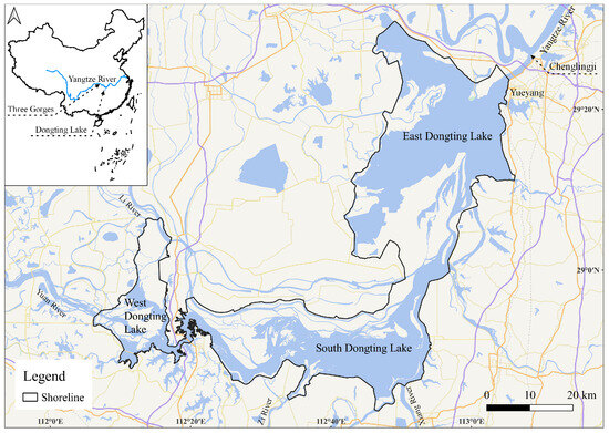
Figure 1.
Location map of Dongting Lake.
2.2. Image Data Acquisition and Preprocessing
The remote sensing data selected for this study include Landsat-5 TM from 1986 to 2010 and Landsat-8 OLI from 2013 to 2021 (path/row: 123/40). Due to the scan line corrector (SLC) failure on Landsat-7 ETM+ since 31 May 2003, all subsequent products have data gaps, resulting in a lack of data from 2011 to 2012.
The Landsat Collection 2 Level-2 surface reflectance (SR) data provided by the United States Geological Survey (USGS) (https://www.usgs.gov/landsat-missions/landsat-collection-2-surface-reflectance, accessed on 6 February 2023) were atmospherically corrected using the Landsat Ecosystem Disturbance Adaptive Processing System (LEDAPS) algorithm for TM images [40] and the Land Surface Reflectance Code (LaSRC) algorithm for OLI images [41].
For each year from 1986 to 2021 during the dry season, all images with few clouds and satisfactory image quality were selected. A total of 35 images were selected based on image completeness and quality as detailed in Table 1. It should be noted that the selected images do not cover West Dongting Lake, so remote sensing monitoring was conducted only over East Dongting Lake and South Dongting Lake. Additionally, an image of Landsat-8 OLI (path/row: 124/40) acquired on 17 September 2022 was obtained to validate the accuracy of the inversion model. After performing cloud removal processing on the image data, water remote sensing reflectance () was calculated, followed by water body extraction.

Table 1.
Landsat images used in the study.
Due to the long revisit period of Landsat (16 days), achieving complete synchronization between in situ data and image used for validation is challenging. In this study, in situ data were taken approximately two days apart from the acquisition of Landsat image. During this period, there was no precipitation, the wind speed was below breeze (3.3 m/s), and the water level remained relatively stable, so the two can be seen to be in near synchronization [35].
2.3. In Situ Data Acquisition
The water quality sampling data of Dongting Lake used to construct the model were collected on 19 September 2022 from 8:55 a.m. to 4:55 p.m. On this date, the water level at Chenglingji hydrological station was 20.18 m at 8:00 a.m., which is below the low water level threshold (24.5 m), indicating conditions similar to the dry season. A total of 31 sampling points were initially recorded for this experiment. After excluding one abnormal point found in the algal bloom area, 30 valid sampling points remained, distributed as shown in Figure 2a. The sampling data for model validation were collected on 15 April 2023, when the water level at Chenglingji hydrological station was again below the low water level threshold [42]. This validation experiment included five sampling points, distributed as shown in Figure 2b. Due to the weather conditions, spectral data were not available in the in situ data collected for this experiment.
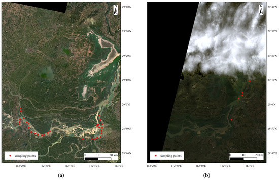
Figure 2.
Distribution of sampling points in Dongting Lake. (a) 19 September 2022; (b) 15 April 2023.
We used a standard sampler, collecting samples from the water surface to a depth of 50 cm [43]. The samples were stored in 1.5 L mineral water bottles and kept in an insulated box at 0–6 °C [43]. Upon returning to the laboratory, TSM concentration was measured using the calcination method [12,35].
Field spectra were measured using the above-water measurement method with ASD FieldSpec (Malvern Panalytical, Malvern, United Kingdom) and TriOS Ramses (TriOS, Rastede, German) spectrometers [44,45], under clear to partly cloudy skies with calm water surfaces. The ASD FieldSpec spectrometer measured the total radiance of water body (), radiance of skylight (), and radiance of the gray reference panel (). The TriOS Ramses spectrometer measured the total radiance of water body (), radiance from skylight (), and downward irradiance above the water surface (). The formula for calculating is as follows:
where is the wavelength, () is the water-leaving radiance, is the reflectance of the air–water interface skylight that can be derived from a look-up table, and () is the reflectance of the gray panel calibrated in the laboratory.
2.4. Hydrological and Meteorological Data
Hydrological data were obtained from Hubei Provincial Department of Water Resources (http://slt.hubei.gov.cn/sjfb/, accessed on 26 March 2024), including water level and discharge, with data available from 1 January 1993 onwards. The water level data used in this study were measured at 8:00 a.m. on the day of image acquisition, approximately 3 h prior to the image capture time. Hydrological conditions at Chenglingji hydrological station were used to represent the overall conditions of Dongting Lake.
Meteorological data were sourced from the National Climatic Data Center (NCDC) of the United States (https://www.ncei.noaa.gov/, accessed on 26 March 2024), covering the temperature, pressure, dew point temperature, wind direction, wind speed, sky cover, and precipitation. Processed meteorological data included the (1) average temperature in the 24 h preceding Landsat image acquisition; (2) average wind speed in the 6–9 h preceding Landsat image acquisition; and (3) 7-day precipitation accumulations preceding Landsat image acquisition. Meteorological conditions at Yueyang meteorological station were used to represent the overall conditions of Dongting Lake.
2.5. Spectral Equivalence Method
The equivalent is computed using the spectral response function (SRF), according to the formula [31]:
where represents the equivalent of Landsat band i (); to denote the wavelength range of the band; and () stands for the measured ().
2.6. Model Construction Method
The empirical models are based on the statistical relationship between the in situ TSM concentration data at sampling points and band values, constructing remote sensing inversion models. These models include linear and non-linear forms such as linear, logarithmic, reciprocal, quadratic, cubic, power, and exponential models. We employed the goodness of fit (coefficient of determination, ), root mean square error (), and mean relative error () to evaluate the different models. These criteria are calculated as
where represents the observed data, is the average of the observed data, denotes the predicted data, and n stands for the total number of observations.
The optimal model was selected based on these evaluation criteria, and used for the inversion of the TSM concentration during the dry season of Dongting Lake from 1986 to 2021.
2.7. Evaluation of Sand Mining Intensity
We assessed the sand mining intensity by counting the number of sand dredgers and sand transporting vessels. The shortwave infrared band (SWIR 1) reflectance in Landsat is less affected by water turbidity, making it more effective for ship identification compared to other bands [46,47,48]. Landsat images displayed in SWIR 1-NIR-Blue false-color composites can effectively differentiate between vessels and the water body [47,48]. However, during the dry season, exposed sandbars and vessels exhibited similar appearances in false-color images. Considering that sand in Dongting Lake is mainly transported through the Yangtze River to markets, we assumed that all vessels from the confluence of the Yangtze River and Dongting Lake (Chenglingji) to the northeast corner of the Dongting Lake shoreline are involved in transporting lake sand, and assessed the sand mining intensity in Dongting Lake by counting the number of suspected vessel pixels identified through visual interpretation of this region as illustrated in Figure 3. To minimize the impact of the specific number of suspected pixels, the Min-Max normalization method was applied to map the data to , rounded to the nearest 0.5.

Figure 3.
Evaluation of sand mining intensity: (a) true-color composite (Red-Green-Blue); (b) false-color composite (SWIR 1-NIR-Blue); (c) vessels identified from false-color images (suspected pixels marked in red).
2.8. Statistical Methods
Pearson’s correlation coefficient was used to analyze the correlation between the elements. For example, it was used to compare equivalent and image , and analyze the relationship between each possible driver and TSM concentration.
The t-test was used to analyze the significance of the differences between the group means. The paired t-test was used to compare the means of two related groups and test for statistical significance. The independent samples t-test was used to compare the means of two independent groups. For example, the former was used to analyze whether there is a significant difference between equivalent and image , and the latter was used to analyze whether there is a significant difference between the TSM concentration in different periods.
3. Results
3.1. Water Spectral Analysis
As shown in Figure 4, the color intensity represents the TSM concentration at sampling points, with deeper red indicating a higher TSM concentration. It is observed that shows a generally positive correlation with the TSM concentration, attributed to the strong backscattering of suspended particulates. Furthermore, from Figure 4b, it is noted that as the TSM concentration increases, the line between the red band and the green band flattens, while those between the red band and the blue band, as well as between the near-infrared band and the other bands, steepen.
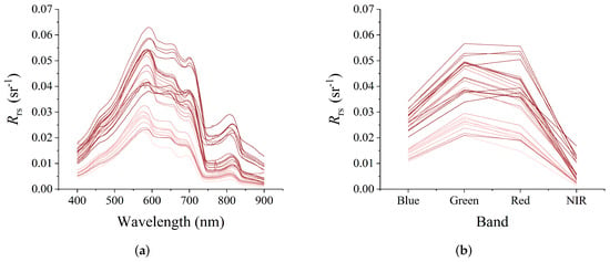
Figure 4.
Spectra of Dongting Lake water on 19 September 2022: (a) measured spectra; (b) equivalent spectra.
For the 18 near-synchronization sampling points (all obtained from experiments conducted on 19 September 2022, with Landsat-8 OLI image from 17 September 2022), the accuracy of the atmospheric correction was assessed using Pearson’s r, , and . It was found that only the green band, the red band , the red band to the blue band ratio, and the red band to the green band ratio have Pearson’s r greater than 0.80 (p < 0.001), and both and are at low levels, making them suitable for inversion.
3.2. Model Construction and Validation
This study obtained a total of 30 valid sampling points from field experiments conducted on 19 September 2022. Twenty randomly selected points were used for model construction, and the remaining ten points were reserved for model validation.
Correlation coefficients between the various bands and band ratios calculated using equivalent , and TSM concentration are presented in Table 2. The table shows high correlations (Pearson’s r > 0.50) between the near-infrared band, the ratio of the red to blue band, the ratio of the near-infrared to blue band, the ratio of the red to green band, the ratio of the near-infrared to green band, the ratio of the near-infrared to red band, and the TSM concentration, meeting the modeling requirements. The table also lists linear regression models constructed using these bands and band ratios, and finds that the models constructed based on the near-infrared band, the ratio of near-infrared to blue band, the ratio of the red to green band, the ratio of the near-infrared to green band, and the ratio of the near-infrared to red band exhibited relatively good fits, with values of 0.87, 0.89, 0.84, 0.90, and 0.82, respectively. However, by evaluating the accuracy of the atmospheric corrections (as shown in Figure 5), we found that the near-infrared band had the worst stability, and the atmospheric corrections of the band ratios containing the near-infrared band were unstable, while the ratio of the red to green band had the best atmospheric correction stability. The difference in the ratio of red to green band derived from two datasets is not statistically significant (p > 0.05). Consequently, the model based on the ratio of the red to green band was selected. The of the model is 18.94 mg/L and the is 27.32%. The red band of Landsat corresponds to band 3 of Landsat-5 TM and band 4 of Landsat-8 OLI, while the green band corresponds to band 2 of Landsat-5 TM and band 3 of Landsat-8 OLI.

Table 2.
The total suspended matter (TSM) concentration inversion model based on the Landsat-8 Operational Land Imager (OLI) image (the selected model is shown in bold).
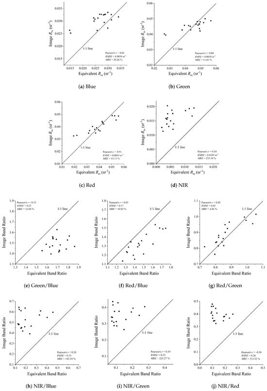
Figure 5.
Evaluation of atmospheric calibration accuracy.
Figure 6a demonstrates that the model exhibits a good fit with an of 0.84, with sample points evenly distributed around the regression line. Figure 6b indicates that the points are evenly distributed around the 1:1 line, indicating good model accuracy.
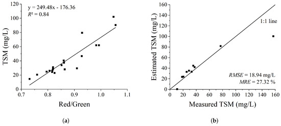
Figure 6.
Landsat inversion model and accuracy assessment for TSM concentration during the dry season in Dongting Lake: (a) linear regression fit for estimating the TSM concentration based on Landsat-8 OLI equivalent remote sensing reflectance (); (b) scatter plot of measured TSM concentration versus estimated TSM concentration based on equivalent .
There is high consistency between Landsat-9 OLI2 and Landsat-8 OLI [49], as well as between Sentinel-2 MSI and Landsat-8 OLI [50]. Therefore, we validated the model using the in situ data on 19 September 2022 and the Landsat-8 OLI image on 17 September 2022, and the in situ data on 15 April 2023 and the Landsat-9 OLI+ image on 30 April 2023 as shown in Figure 7a. The matching valid points are 18 and 5, respectively. The figure illustrates that there is a strong correlation between the measured TSM and estimated TSM (Pearson’s r = 0.73, p < 0.001), with an of 15.40 mg/L and an of 40.36%. Additionally, the model was tested on Sentinel-2 MSI image from 19 September 2022, synchronized with the in situ experiment on the same day, with a total of 30 valid points. As shown in Figure 7b, the measured and estimated TSM data are highly correlated (Pearson’s r = 0.84, p < 0.001), with an of 19.24 mg/L and an of 42.43%.
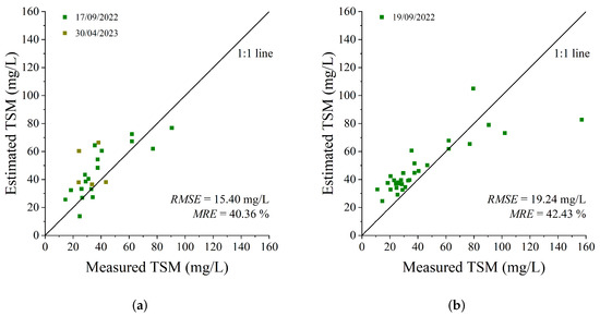
Figure 7.
Comparison of measured TSM and estimated TSM based on imagery: (a) validation based on Landsat-8/9 OLI/OLI2 imagery; (b) validation based on synchronized Sentinel-2 MultiSpectral Instrument (MSI) imagery.
3.3. Spatial and Temporal Changes in TSM Concentration during the Dry Season in Dongting Lake
The developed TSM concentration inversion model for the dry season in Dongting Lake was applied to Landsat images from 1986 to 2021, estimating the spatial distribution of the TSM concentration during this period as shown in Figure 8. Figure 8 indicates that the estimated TSM concentration during the dry season in Dongting Lake from 1986 to 2021 ranges between 0 and 200 mg/L, with the majority of areas having a TSM concentration between 0 and 120 mg/L. During the dry season, there is no significant spatial variation in the TSM concentration within East Dongting Lake and South Dongting Lake. However, in 1993, the TSM concentration on the western side of East Dongting Lake was notably higher compared to the eastern side, and the TSM concentration on the northern side of South Dongting Lake was significantly higher than that on the southern side. Between 2015 and 2017, and also in 2021, the TSM concentration on the northern side of East Dongting Lake was significantly higher compared to the southern side.
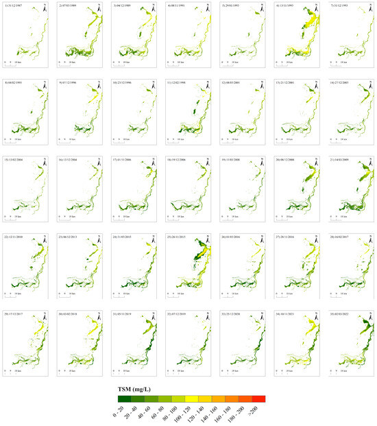
Figure 8.
Distribution of the TSM concentration during the dry season of Dongting Lake, 1986–2021.
Following the exclusion of outliers in each TSM concentration distribution map—the top and bottom 2% outliers—statistics including the full-domain mean, minimum, maximum, median, standard deviation, and variation coefficient were computed as presented in Table A1. By averaging the mean TSM concentration from all valid images for each year, we derived the inter-annual variation in the TSM concentration during the dry season of Dongting Lake as illustrated in Figure 9. Here, W denotes the whole lake, E represents East Dongting Lake, and S indicates South Dongting Lake.

Figure 9.
Inter-annual variation of TSM concentration during the dry season in Dongting Lake, 1986–2021.
According to Figure 9, the dry season TSM concentration across Dongting Lake ranged from 41.61 to 75.44 mg/L between 1986 and 2021. During this period, TSM concentration exhibited an increasing trend from 1986 to 1991, followed by a decline from 1991 to 2007, a subsequent increase from 2007 to 2017, and a decrease from 2017 to 2021. The highest average TSM concentration for the whole lake occurred in 1991 at 75.44 mg/L, while the lowest was recorded in 2020 at 41.61 mg/L.
For East Dongting Lake, the average dry season TSM concentration ranged from 47.79 to 88.56 mg/L between 1986 and 2021. The highest TSM concentration was observed in 1991 at 88.56 mg/L, and the lowest in 2020 at 47.79 mg/L. Similarly, South Dongting Lake exhibited a dry season TSM concentration ranging from 32.80 to 68.33 mg/L between 1986 and 2021. The highest average TSM concentration occurred in 1991 at 68.33 mg/L, with the lowest recorded in 2014 at 32.80 mg/L.
In most years during the dry season, TSM concentration in East Dongting Lake was higher than that in South Dongting Lake, except for a slight dip in 2021. This disparity may be attributed to the closer proximity of East Dongting Lake to the urban area of Yueyang, where human activities are more substantial, generating more domestic sewage, industrial wastewater, and agricultural runoff, which can directly influence the TSM concentration in Dongting Lake through increasing exogenous inputs [32]. Additionally, activities such as shipping and sand mining disturb the lake bed, resuspending sediments, and enhancing the TSM concentration [25].
4. Discussion
4.1. Model Suitability
The in situ TSM concentration data used in this study were gathered on 19 September 2022, and the water level recorded at 8:00 a.m. from Chenglingji hydrological station was 20.18 m, indicating hydrological conditions close to the dry season, as it was below the low water level threshold of 24.5 m. Therefore, the TSM concentration during the dry season derived from this model inversion are reasonably trustworthy.
Additionally, the field experiments provided relatively scarce in situ TSM concentration data, ranging from 11 to 157 mg/L. The data utilized for modeling fell within 14.5 to 102 mg/L, while the validation data encompassed 11–157 mg/L. This range covers the estimated TSM concentration for most regions of Dongting Lake. However, these data do not encompass lower (e.g., less than 11 mg/L) or higher (e.g., greater than 157 mg/L) concentrations, potentially limiting the model’s explanatory power for these areas.
Before selecting the bands or band combinations for modeling, we compared single-bands and band ratios derived from equivalent and image as shown in Figure 5. Our priority was to choose bands or combinations that closely align to ensure the model’s applicability. However, we observed that only red band, green band and their ratio are not significantly different (p > 0.05). We attribute this discrepancy to the atmospheric correction algorithms provided by USGS, primarily optimized for terrestrial areas, which may introduce challenges when applied to aquatic environments [51,52,53].
Considering the above factors and the evaluation metrics of various models, we ultimately chose the model based on the ratio of the red band to the green band. Previous studies have also demonstrated the effectiveness of the ratio of the red to green band in monitoring the TSM concentration [25,54]. In addition, as shown in Figure 10, there is good consistency between the ratio of the red to green band based on Landsat-5 TM and Landsat-8 OLI.
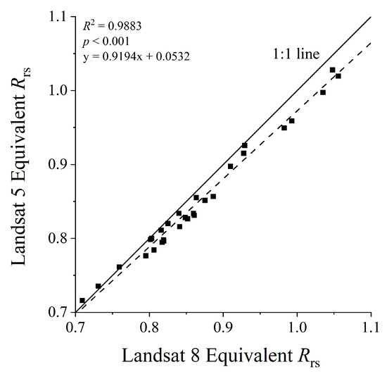
Figure 10.
Consistency of the ratio of the red to green band based on Landsat-5 Thematic Mapper (TM) and Landsat-8 OLI.
In comparison to analogous research works utilizing Landsat for the retrieval of TSM concentration in Dongting Lake as illustrated in Figure 11, the model employed in this study exhibits better precision. Zheng et al.’s model [31] demonstrates superior performance on equivalent data, yet exhibits mediocre results on imagery. This discrepancy can be attributed to the utilization of the near-infrared band in the model. The model proposed by Wu et al. [30] is based on the water-leaving reflectance calculated using Landsat-8 OLI imagery. Consequently, it performs well on imagery but less well on equivalent .
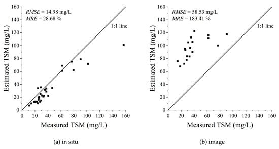
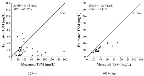
Figure 11.
Comparison to analogous research: (a) applying Zheng et al.’s model [31] to equivalent using in situ spectra; (b) applying Zheng et al.’s model [31] to Landsat-8 OLI image; (c) applying Wu et al.’s model [30] to equivalent using in situ spectra; (d) applying Wu et al.’s model [30] to Landsat-8 OLI image.
4.2. Analysis of Driving Factors
4.2.1. Influence of Hydrological and Meteorological Factors on TSM Concentration in Dongting Lake during the Dry Season
Previous studies have indicated that the TSM concentration in lakes correlates with hydrological factors such as the water level, as well as meteorological factors including precipitation, temperature, and wind speed [31,55,56]. Analyzing the relationship between the TSM concentration during the dry season of Dongting Lake and hydrological factors (water level) and meteorological factors (7-day precipitation accumulations, temperature and wind speed) as shown in Figure 12, we have found a significant positive correlation between the TSM concentration and both the water level (Pearson’s r = 0.43, p < 0.05) and 7-day precipitation accumulations (Pearson’s r = 0.37, p < 0.05). However, there is no evidence of a correlation between the TSM concentration and meteorological factors such as temperature or wind speed (p > 0.05). Zheng et al. [31] also found a significant positive correlation between TSM concentration during the wet season of Dongting Lake and both the water level and 7-day precipitation accumulations. This may be explained by the fact that during the wet season, the higher the water level, the greater the inflow into the lake, resulting in higher sediment influx and thus a higher TSM concentration. Conversely, during the dry season, the lower the water level, the greater the outflow from the lake, leading to a lower TSM concentration, as more suspended matter is carried away. Precipitation affects the TSM concentration by the increasing runoff input mainly. Considering that sediment resuspension requires a wind speed above the critical threshold, we separately analyzed paired data with wind speed of at least 2.5 m/s, resulting in Pearson’s r value of 0.18, showing slight improvements compared to previous results but with a p value still greater than 0.05, indicating no statistically significant correlation between the TSM concentration and wind speed. This could be attributed to the deeper water depth of Dongting Lake compared to a nearshore and shallow lake like Lake Taihu, where sediment resuspension is less likely [56,57,58]. Additionally, the fact that the water body of Dongting Lake is not easy to be stirred up and the low biological productivity in the water during the dry season of Dongting Lake may also explain why there is no statistically significant correlation between the TSM concentration and temperature.
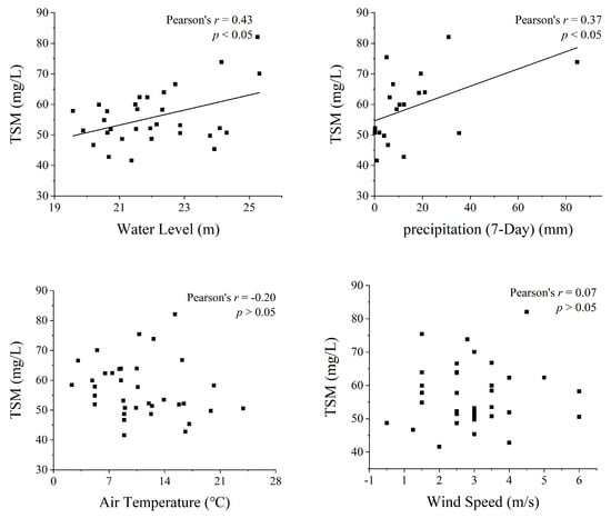
Figure 12.
Influence of natural factors on the TSM concentration in Dongting Lake during the dry season (the black line shows the linear regression of the TSM concentration with natural factors).
4.2.2. Impact of Human Activities on TSM Concentration during the Dry Season in Dongting Lake
Human activities affecting the TSM concentration in lakes include sand mining and hydraulic engineering. This study quantifies the intensity of sand mining based on vessel coverage area from Chenglingji to the northeast corner of the Dongting Lake shoreline. It reveals that large-scale sand mining in Dongting Lake began around 2006 and 2007 and was regulated after governmental intervention in 2017, consistent with related studies and news reports [59,60]. Additionally, the Three Gorges Dam first impounded water in 2003. Therefore, this study selected the relatively later time point (2006) as the period when human activities intensified, dividing the study period into 1986–2005 and 2006–2021, analyzing the correlation between TSM concentration and water level during the dry season. As shown in Figure 13, the TSM concentration was significantly positively correlated with water level during 1986–2005 with Pearson’s r reaching 0.75 (p < 0.05), but there was no evidence of correlation during 2006–2021. This suggests that in the earlier period, the TSM concentration during the dry season was primarily driven by natural factors represented by the water level due to fewer human activities. In contrast, the influence of human activities such as the rise in sand mining and the impoundment of the Three Gorges Dam in the later period weakened the influence of natural factors represented by the water level on the TSM concentration.
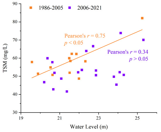
Figure 13.
Influence of the water level during different periods on the TSM concentration in Dongting Lake during the dry season (the orange line shows the linear regression of the TSM concentration with the water level between 1986 and 2005).
Observing Figure 13, we note that under similar water levels, the TSM concentration in the later period was often lower than that in the earlier period. Furthermore, independent t-tests on TSM concentration during the dry season in these two periods reveal that the average TSM concentration in the later period was significantly lower (p < 0.05), indicating that intensified human activities may have contributed to the decreased TSM concentration levels.
To investigate the impact of sand mining on the TSM concentration during the dry season in Dongting Lake, we plotted the variation in TSM concentration and sand mining intensity from 2006 to 2021. As shown in Figure 14a, since 2006, both the TSM concentration during Dongting Lake’s dry season and the intensity of sand mining have exhibited analogous increasing trends, generally indicating a positive correlation. Detailed analysis of the correlation between the TSM concentration and sand mining intensity, as depicted in Figure 14b, shows a significant positive correlation with Pearson’s r, reaching 0.53 (p < 0.05).
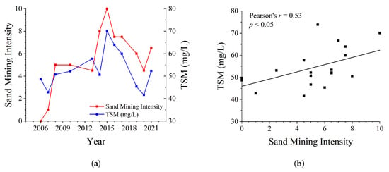
Figure 14.
Relationship between the TSM concentration and sand mining intensity during the dry season of Dongting Lake, 2006–2021: (a) variation in the TSM concentration and sand mining intensity; (b) correlation between the TSM concentration and sand mining intensity (the black line shows the linear regression of the TSM concentration with sand mining intensity).
We analyzed the potential impact of the Three Gorges Dam on the TSM concentration. The sediment in Dongting Lake mainly comes from the Yangtze River [26,27], so the magnitude of sediment transport in the Yangtze River has an impact on the TSM concentration in Dongting Lake. Studies have shown a significant reduction in sediment inflow from upstream into Dongting Lake since the impoundment of the Three Gorges Dam in 2003, with sediment inflow during the dry season even approaching zero and a substantial reduction in sediment of Dongting Lake [26,27]. Therefore, we speculate that although sand mining will, to some extent, make the TSM concentration higher in Dongting Lake during the dry season, this effect is weaker than that of the Three Gorges Dam.
In summary, before 2006, the TSM concentration during the dry season in Dongting Lake was primarily driven by natural forces like water level, but since 2006, with the impoundment of the Three Gorges Dam and the rise in sand mining, human activities have replaced the water level as the main driving factor of the TSM concentration during the dry season.
5. Conclusions
This study developed a model for estimating TSM concentration in Dongting Lake using the ratio of the red to green band from Landsat imagery. The model was applied to estimate the spatial–temporal variations of the TSM concentration during the dry season from 1986 to 2021. In most years, there was no significant spatial variation in the TSM concentration within East Dongting Lake and South Dongting Lake; however, the concentration was generally higher in East Dongting Lake, probably due to its proximity to Yueyang City. Our analysis shows that before 2006, the TSM concentration was primarily influenced by water level, but since 2006, it has mainly been affected by human activities such as the operation of the Three Gorges Dam and sand mining. The impoundment of the Three Gorges Dam generally reduced the TSM concentration, whereas sand mining has increased it. Nevertheless, the impact of the reservoir has outweighed that of sand mining, resulting in a notable decline in TSM concentration since 2006 compared to earlier years.
The approach and findings of this study are crucial for the long-term monitoring of lake environments. Our results demonstrate that the Three Gorges Dam has exerted a persistent and stabilizing downward impact on the TSM concentration in Dongting Lake during the dry season. In contrast, sand mining, which has intensified since 2006, has temporarily increased the TSM levels. Notably, local authorities began regulating sand mining in 2017, and the long-term TSM data can be instrumental in assessing the effectiveness of these policies. Moreover, this study highlights the combined impacts of climate change and human activities—especially those related to the Three Gorges Dam and sand mining—offering valuable insights for the management of similar lakes worldwide using remote sensing techniques.
Author Contributions
Conceptualization, Q.S.; methodology, Y.S.; software, Y.S.; validation, Y.S.; formal analysis, Q.S. and Y.Y.; investigation, Y.S.; resources, Y.Z. (Yuting Zhou), W.X., W.L., H.G., J.S. and Y.Z. (Yuting Zhang); data curation, Y.Z. (Yuting Zhou) and W.X.; writing—original draft preparation, Y.S.; writing—review and editing, Q.S. and Y.Y.; visualization, W.L.; supervision, Q.S. and Y.Y.; project administration, Q.S. and Y.Y.; funding acquisition, Q.S. All authors have read and agreed to the published version of the manuscript.
Funding
This research was funded by the National Key Research and Development Program of China (2021YFB3901101).
Data Availability Statement
The data presented in this study are available on request from the corresponding author due to privacy reason.
Acknowledgments
The authors would like to thank Qian Shen from the Key Laboratory of Digital Earth Science, Aerospace Information Research Institute, Chinese Academy of Sciences, for the help with writing. We are also thankful to all of the anonymous reviewers for their constructive comments on the study.
Conflicts of Interest
The authors declare no conflicts of interest.
Appendix A

Table A1.
Statistics of total suspended matter concentration (TSM, mg/L) during the dry season in Dongting Lake from 1986 to 2021. S.D. is the standard deviation (mg/L), and C.V. is the variation coefficient (%).
Table A1.
Statistics of total suspended matter concentration (TSM, mg/L) during the dry season in Dongting Lake from 1986 to 2021. S.D. is the standard deviation (mg/L), and C.V. is the variation coefficient (%).
| Date | Mean | Maximum | Minimum | Median | S.D. | C.V. |
|---|---|---|---|---|---|---|
| 31 December 1987 | 63.92 | 127.67 | 8.57 | 64.32 | 13.97 | 21.86 |
| 7 March 1989 | 63.77 | 197.35 | 1.92 | 64.64 | 18.74 | 29.39 |
| 4 December 1989 | 66.78 | 160.36 | 1.00 | 70.09 | 25.64 | 38.39 |
| 8 November 1991 | 75.44 | 149.21 | 6.91 | 77.17 | 21.06 | 27.92 |
| 29 January 1993 | 57.84 | 124.10 | 8.55 | 57.88 | 14.07 | 24.32 |
| 13 November 1993 | 82.09 | 179.07 | 1.01 | 88.48 | 28.76 | 35.03 |
| 31 December 1993 | 62.36 | 146.83 | 9.80 | 62.08 | 17.20 | 27.58 |
| 4 February 1995 | 51.94 | 117.84 | 8.13 | 52.49 | 13.89 | 26.74 |
| 7 December 1996 | 62.32 | 164.61 | 1.02 | 63.06 | 28.66 | 46.00 |
| 23 December 1996 | 50.76 | 141.18 | 2.27 | 50.25 | 18.53 | 36.51 |
| 12 February 1998 | 58.25 | 175.72 | 1.01 | 57.54 | 29.15 | 50.05 |
| 8 March 2001 | 59.97 | 128.18 | 6.57 | 59.73 | 19.38 | 32.32 |
| 21 December 2001 | 58.43 | 157.86 | 1.01 | 56.50 | 25.55 | 43.73 |
| 27 December 2003 | 54.88 | 159.50 | 1.06 | 53.79 | 22.53 | 41.06 |
| 13 February 2004 | 51.41 | 128.68 | 1.02 | 53.48 | 20.78 | 40.43 |
| 13 December 2004 | 48.72 | 162.10 | 1.33 | 48.54 | 19.34 | 39.71 |
| 1 November 2006 | 49.75 | 159.39 | 1.00 | 49.26 | 19.97 | 40.14 |
| 19 December 2006 | 48.68 | 139.99 | 1.10 | 47.97 | 20.64 | 42.41 |
| 11 March 2008 | 42.81 | 124.66 | 1.08 | 40.69 | 16.68 | 38.97 |
| 8 December 2008 | 53.17 | 171.91 | 1.00 | 53.25 | 25.31 | 47.59 |
| 14 March 2009 | 50.76 | 142.24 | 1.00 | 48.15 | 24.21 | 47.70 |
| 12 November 2010 | 52.18 | 151.49 | 1.00 | 51.26 | 24.38 | 46.73 |
| 6 December 2013 | 57.75 | 110.83 | 1.00 | 60.10 | 22.86 | 39.59 |
| 31 March 2015 | 50.58 | 121.80 | 1.00 | 48.95 | 27.10 | 53.57 |
| 26 November 2015 | 70.06 | 163.43 | 1.00 | 74.00 | 31.02 | 44.27 |
| 1 March 2016 | 53.49 | 118.13 | 1.00 | 57.28 | 26.43 | 49.41 |
| 28 November 2016 | 63.95 | 148.87 | 1.00 | 63.47 | 25.00 | 39.09 |
| 16 February 2017 | 51.90 | 144.27 | 1.00 | 53.06 | 24.52 | 47.24 |
| 17 December 2017 | 59.94 | 125.13 | 1.02 | 54.50 | 22.99 | 38.35 |
| 3 February 2018 | 66.60 | 127.11 | 1.00 | 65.35 | 23.21 | 34.85 |
| 5 November 2019 | 45.38 | 105.29 | 1.00 | 43.38 | 21.50 | 47.39 |
| 7 December 2019 | 46.73 | 123.88 | 1.00 | 44.77 | 19.65 | 42.04 |
| 25 December 2020 | 41.61 | 98.48 | 1.00 | 38.75 | 15.80 | 37.97 |
| 10 November 2021 | 73.87 | 153.14 | 1.02 | 76.30 | 23.42 | 31.70 |
| 2 March 2022 | 52.25 | 127.99 | 1.00 | 51.48 | 21.52 | 41.19 |
References
- Weyhenmeyer, G.A.; Håkanson, L.; Meili, M. A Validated Model for Daily Variations in the Flux, Origin, and Distribution of Settling Particles within Lakes. Limnol. Oceanogr. 1997, 42, 1517–1529. [Google Scholar] [CrossRef]
- Pang, Y.; Yan, R.; Yu, Z.; Li, Y.; Li, R. Suspension-sedimentation of sediment and release amount of internal load in Lake Taihu affected by wind. Environ. Sci. 2008, 29, 2456–2464. [Google Scholar] [CrossRef]
- Blom, G.; van Duin, E.H.S.; Lijklema, L. Sediment Resuspension and Light Conditions in Some Shallow Dutch Lakes. Water Sci. Technol. 1994, 30, 243–252. [Google Scholar] [CrossRef]
- Kirk, J.T.O. Light and Photosynthesis in Aquatic Ecosystems, 3rd ed.; Cambridge University Press: Cambridge, UK; New York, NY, USA, 2011. [Google Scholar]
- Zhang, Y.; Qin, B.; Chen, W.; Luo, L. A Study on Total Suspended Matter in Lake Taihu. Resour. Environ. Yangtze Basin 2004, 13, 266–271. [Google Scholar]
- Zhang, B.; Li, J.; Shen, Q.; Wu, Y.; Zhang, F.; Wang, S.; Yao, Y.; Guo, L.; Yin, Z. Recent Research Progress on Long Time Series and Large Scale Optical Remote Sensing of Inland Water. J. Remote Sens. 2021, 25, 37–52. [Google Scholar] [CrossRef]
- Ouma, Y.O.; Noor, K.; Herbert, K. Modelling Reservoir Chlorophyll-a, TSS, and Turbidity Using Sentinel-2A MSI and Landsat-8 OLI Satellite Sensors with Empirical Multivariate Regression. J. Sens. 2020, 2020, 8858408. [Google Scholar] [CrossRef]
- Wen, Z.; Wang, Q.; Ma, Y.; Jacinthe, P.A.; Liu, G.; Li, S.; Shang, Y.; Tao, H.; Fang, C.; Lyu, L.; et al. Remote Estimates of Suspended Particulate Matter in Global Lakes Using Machine Learning Models. Int. Soil Water Conserv. Res. 2024, 12, 200–216. [Google Scholar] [CrossRef]
- Nechad, B.; Ruddick, K.G.; Park, Y. Calibration and Validation of a Generic Multisensor Algorithm for Mapping of Total Suspended Matter in Turbid Waters. Remote Sens. Environ. 2010, 114, 854–866. [Google Scholar] [CrossRef]
- Han, B.; Loisel, H.; Vantrepotte, V.; Meriaux, X.; Bryere, P.; Ouillon, S.; Dessailly, D.; Xing, Q.; Zhu, J. Development of a Semi-Analytical Algorithm for the Retrieval of Suspended Particulate Matter from Remote Sensing over Clear to Very Turbid Waters. Remote Sens. 2016, 8, 211. [Google Scholar] [CrossRef]
- Shi, K.; Zhang, Y.; Zhu, G.; Liu, X.; Zhou, Y.; Xu, H.; Qin, B.; Liu, G.; Li, Y. Long-Term Remote Monitoring of Total Suspended Matter Concentration in Lake Taihu Using 250 m MODIS-Aqua Data. Remote Sens. Environ. 2015, 164, 43–56. [Google Scholar] [CrossRef]
- Cao, Z.; Duan, H.; Feng, L.; Ma, R.; Xue, K. Climate- and Human-Induced Changes in Suspended Particulate Matter over Lake Hongze on Short and Long Timescales. Remote Sens. Environ. 2017, 192, 98–113. [Google Scholar] [CrossRef]
- Kari, E.; Kratzer, S.; Beltran-Abaunza, J.M.; Harvey, E.T.; Vaiciute, D. Retrieval of Suspended Particulate Matter from Turbidity—Model Development, Validation, and Application to MERIS Data over the Baltic Sea. Int. J. Remote Sens. 2017, 38, 1983–2003. [Google Scholar] [CrossRef]
- Jiang, D.; Matsushita, B.; Pahlevan, N.; Gurlin, D.; Lehmann, M.K.; Fichot, C.G.; Schalles, J.; Loisel, H.; Binding, C.; Zhang, Y.; et al. Remotely Estimating Total Suspended Solids Concentration in Clear to Extremely Turbid Waters Using a Novel Semi-Analytical Method. Remote Sens. Environ. 2021, 258, 112386. [Google Scholar] [CrossRef]
- Liu, H.; Li, Q.; Shi, T.; Hu, S.; Wu, G.; Zhou, Q. Application of Sentinel 2 MSI Images to Retrieve Suspended Particulate Matter Concentrations in Poyang Lake. Remote Sens. 2017, 9, 761. [Google Scholar] [CrossRef]
- Balasubramanian, S.; Pahlevan, N.; Smith, B.; Binding, C.; Schalles, J.; Loisel, H.; Gurlin, D.; Greb, S.; Alikas, K.; Randla, M.; et al. Robust Algorithm for Estimating Total Suspended Solids (TSS) in Inland and Nearshore Coastal Waters. Remote Sens. Environ. 2020, 246, 111768. [Google Scholar] [CrossRef]
- Claverie, M.; Vermote, E.F.; Franch, B.; Masek, J.G. Evaluation of the Landsat-5 TM and Landsat-7 ETM + Surface Reflectance Products. Remote Sens. Environ. 2015, 169, 390–403. [Google Scholar] [CrossRef]
- Chen, J.; Zhu, W. Consistency Evaluation of Landsat-7 and Landsat-8 for Improved Monitoring of Colored Dissolved Organic Matter in Complex Water. Geocarto Int. 2022, 37, 91–102. [Google Scholar] [CrossRef]
- Han, W.; Huang, C.; Wang, Y.; Gu, J. Study on the Area Variation of Qinghai Lake Based on Long-Term Landsat 5/8 Multi-Band Remote Sensing Imagery. Adv. Earth Sci. 2019, 34, 346–355. [Google Scholar] [CrossRef]
- Gholizadeh, M.H.; Melesse, A.M.; Reddi, L. A Comprehensive Review on Water Quality Parameters Estimation Using Remote Sensing Techniques. Sensors 2016, 16, 1298. [Google Scholar] [CrossRef]
- Xiong, Y.; Wang, K.; Lan, W.; Qi, H. Evaluation of the Lake Recovery Area Eco-Compensation in Dongting Lake Wetland. Acta Geogr. Sin. 2004, 59, 772–780. [Google Scholar]
- Zhuang, D. The Evaluation of the Ecosystem Services Value in Dongting Lake Wetland. Econ. Geogr. 2004, 24, 391–394+432. [Google Scholar]
- Jing, H.; Hua, L.; Chen, Y.; Shan, W.; Shi, W.; Huang, Z.; Jiao, Z. Pollution characteristics of runoff in urban storm sewer and its impaction to receiving water. Environ. Chem. 2012, 31, 208–215. [Google Scholar]
- Lu, D.; Li, J.; Filippi, A. Analysis of Total Suspended Solids Concentration in Water Bodies of East Lake Based on Long Time Series Landsat Imagery. Eng. J. Wuhan Univ. 2019, 52, 854–861. [Google Scholar] [CrossRef]
- Zhang, Y.; Zhang, Y.; Zha, Y.; Shi, K.; Zhou, Y.; Wang, M. Remote Sensing Estimation of Total Suspended Matter Concentration in Xin’anjiang Reservoir Using Landsat 8 Data. Environ. Sci. 2015, 36, 56–63. [Google Scholar]
- Wang, L.; Tian, Z.; Li, Y.; Chen, J.; Li, L.; Wang, X.; Zhao, Y.; Zheng, B. Trend and Driving Factors of Water Environment Change in Dongting Lake in the Last 30 Years. Res. Environ. Sci. 2020, 33, 1140–1149. [Google Scholar]
- Zhang, L.; Ma, J.; Zhang, Q.; Yu, R.; Ren, B.; Wang, Y.; Zhang, Y. Characteristics of Runoff-Sediment Variation of Dongting Lake in Recent Six Decades and Its Relationship with Human Activities. J. Yangtze River Sci. Res. Inst. 2021, 38, 14–20. [Google Scholar]
- Zhang, G.; Lu, S.; Tian, Q. Analysis of Spatial-Temporal Variations of Total Nitrogen and Total Phosphorus Concentrations and Their Influencing Factors in Dongting Lake in the Past Two Decades. Environ. Chem. 2016, 35, 2377–2385. [Google Scholar]
- Wu, G.; Liu, L.; Chen, F.; Fei, T. Developing MODIS-based Retrieval Models of Suspended Particulate Matter Concentration in Dongting Lake, China. Int. J. Appl. Earth Obs. Geoinf. 2014, 32, 46–53. [Google Scholar] [CrossRef]
- Wu, G.; Cui, L.; Liu, L.; Chen, F.; Fei, T.; Liu, Y. Statistical Model Development and Estimation of Suspended Particulate Matter Concentrations with Landsat 8 OLI Images of Dongting Lake, China. Int. J. Remote Sens. 2015, 36, 343–360. [Google Scholar] [CrossRef]
- Zheng, Z.; Li, Y.; Guo, Y.; Xu, Y.; Liu, G.; Du, C. Landsat-Based Long-Term Monitoring of Total Suspended Matter Concentration Pattern Change in the Wet Season for Dongting Lake, China. Remote Sens. 2015, 7, 13975–13999. [Google Scholar] [CrossRef]
- Peng, B.; Chen, Z.; Li, J.; Luo, W.; Gan, J.; Zeng, R. Monitoring Water Quality of Dongting Lake Region Based on GF-1 Image. Geogr. Res. 2018, 37, 1683–1691. [Google Scholar]
- Chen, J.; Huang, J.; Zhang, X.; Chen, J.; Chen, X. Monitoring Total Suspended Solids Concentration in Poyang Lake via Machine Learning and Landsat Images. J. Hydrol. Reg. Stud. 2023, 49, 101499. [Google Scholar] [CrossRef]
- Zheng, Y.; Lu, J.; Chen, L.; Chen, X. Spatial-Temporal Dynamic Monitoring of Sand Dredging Activities Based on GF-1 WFV in Lake Poyang during 2013–2020. J. Lake Sci. 2022, 34, 2144–2155. [Google Scholar] [CrossRef]
- Yin, Z.; Li, J.; Liu, Y.; Zhang, F.; Wang, S.; Xie, Y.; Gao, M. Decline of Suspended Particulate Matter Concentrations in Lake Taihu from 1984 to 2020: Observations from Landsat TM and OLI. Opt. Express 2022, 30, 22572–22589. [Google Scholar] [CrossRef]
- Ma, R.; Dai, J. Quantitative Estimation of Chlorophyll-a and Total Suspended Matter Concentration with Landsat ETM Based on Field Spectral Features of Lake Taihu. J. Lake Sci. 2005, 17, 97–103. [Google Scholar]
- Encyclopedia of China Publishing House. Encyclopedia of China: Geography of China, 1st ed.; Encyclopedia of China Publishing House: Beijing, China, 1993. [Google Scholar]
- Cheng, J.; Xu, L.; Wang, Q.; Yan, B.; Wan, R.; Jiang, J.; You, H. Temporal and Spatial Variations of Water Level and Its Driving Forces in Lake Dongting over the Last Three Decades. J. Lake Sci. 2017, 29, 974–983. [Google Scholar] [CrossRef]
- Zhang, Y. Water and Sediment Exchanges between Rivers and Lakes in the Middle and Lower Yangtze River Basin. Master’s Dissertation, East China Normal University, Shanghai, China, 2022. [Google Scholar]
- Masek, J.; Vermote, E.; Saleous, N.; Wolfe, R.; Hall, F.; Huemmrich, K.; Gao, F.; Kutler, J.; Lim, T.K. A Landsat Surface Reflectance Dataset for North America, 1990–2000. IEEE Geosci. Remote Sens. Lett. 2006, 3, 68–72. [Google Scholar] [CrossRef]
- Vermote, E.; Justice, C.; Claverie, M.; Franch, B. Preliminary Analysis of the Performance of the Landsat 8/OLI Land Surface Reflectance Product. Remote Sens. Environ. 2016, 185, 46–56. [Google Scholar] [CrossRef] [PubMed]
- Feng, Y.; Xu, D.; Li, Z. The Yangtze River’s Water Inflow into the Lake Has Slightly Increased, and Dongting Lake Has Ended Its 305-Day-Long Low Dry State. Available online: https://www.hunan.gov.cn/hnszf/hnyw/zwdt/202306/t20230607_29369235.html (accessed on 9 September 2024).
- Surface Water Quality Monitoring Procedures, Volume 1: Physical and Chemical Monitoring Methods. Available online: https://www.tceq.texas.gov/publications/rg/rg-415 (accessed on 30 August 2024).
- Mueller, J.L.; Fargion, G.S.; Trees, C.; Austin, R.W.; Pietras, C.; Hooker, S.; Holben, B.; McClain, C.R.; Clark, D.K.; Yuen, M. Ocean Optics Protocols for Satellite Ocean Color Sensor Validation. Available online: https://ntrs.nasa.gov/citations/20030063139 (accessed on 26 March 2024).
- Tang, J.; Tian, G.; Wang, X.; Wang, X.; Song, Q. The Methods of Water Spectra Measurement and Analysis I: Above-Water Method. J. Remote Sens. 2004, 8, 37–44. [Google Scholar] [CrossRef]
- Cui, L.; Zhai, Y.; Wu, G. Dredging Being Moved Southward Enlarges the Impacted Region in Poyang Lake: The Evidences from Multi-Remote Sensing Images. Acta Ecol. Sin. 2013, 33, 3520–3525. [Google Scholar] [CrossRef]
- Wang, P.; Zhang, X.; Qi, S. Was the Trend of the Net Sediment Flux in Poyang Lake, China, Altered by the Three Gorges Dam or by Sand Mining? Environ. Earth Sci. 2019, 78, 64. [Google Scholar] [CrossRef]
- Deng, M.; Li, Q.; Li, W.; Lai, G.; Pan, Y. Impacts of Sand Mining Activities on the Wetland Ecosystem of Poyang Lake (China). Land 2022, 11, 1364. [Google Scholar] [CrossRef]
- Kabir, S.; Pahlevan, N.; O’Shea, R.E.; Barnes, B.B. Leveraging Landsat-8/-9 Underfly Observations to Evaluate Consistency in Reflectance Products over Aquatic Environments. Remote Sens. Environ. 2023, 296, 113755. [Google Scholar] [CrossRef]
- Pahlevan, N.; Chittimalli, S.K.; Balasubramanian, S.V.; Vellucci, V. Sentinel-2/Landsat-8 Product Consistency and Implications for Monitoring Aquatic Systems. Remote Sens. Environ. 2019, 220, 19–29. [Google Scholar] [CrossRef]
- Echavarria-Caballeroa, C.; Dominguez-Gomez, J.A.; Gonzalez-Garcia, C.; Garcia-Garcia, M.J. Assessment of Landsat 5 Images Atmospherically Corrected with LEDAPS in Water Quality Time Series. Can. J. Remote Sens. 2019, 45, 691–706. [Google Scholar] [CrossRef]
- Ilori, C.O.; Pahlevan, N.; Knudby, A. Analyzing Performances of Different Atmospheric Correction Techniques for Landsat 8: Application for Coastal Remote Sensing. Remote Sens. 2019, 11, 469. [Google Scholar] [CrossRef]
- Jin, Y.; Hao, Z.; Huang, H.; Wang, T.; Mao, Z.; Pan, D. Evaluation of LaSRC Aerosol Optical Depth from Landsat-8 and Sentinel-2 in Guangdong-Hong Kong-Macao Greater Bay Area, China. Atmos. Environ. 2022, 280, 119128. [Google Scholar] [CrossRef]
- Wang, F.; Han, L.; Kung, H.T.; Van Arsdale, R.B. Applications of Landsat-5 TM Imagery in Assessing and Mapping Water Quality in Reelfoot Lake, Tennessee. Int. J. Remote Sens. 2006, 27, 5269–5283. [Google Scholar] [CrossRef]
- Wang, L. Study on Temporal and Spatial Variation and Influencing Factors of Water Quality Parameters in Salt Lake Area —The Example of the Charkhan Salt Lake. Master’s Thesis, Northwest Normal University, Lanzhou, China, 2023. [Google Scholar]
- Hu, Y.; Zhang, Y.; Yang, B.; Zhang, Y. Short-Term Dynamics and Driving Factors of Total Suspended Matter Concentration in Lake Taihu Using High Frequent Geostationary Ocean Color Imager Data. J. Lake Sci. 2018, 30, 992–1003. [Google Scholar] [CrossRef]
- Li, K. Remote Sensing Inversion and Driving Factor Analysis of Suspended Matter in the Nearshore Waters of Zhuhai, China. Master’s Thesis, Nanjing University of Information Science & Technology, Nanjing, China, 2022. [Google Scholar]
- Zhou, Y.; Liu, J.; Xu, X.; Qi, C.; Wu, X.; Lin, H.; Shi, K. Response of Suspended Solids and Dissolved Nutrients in Littoral Zone of Lake Taihu under Wind-Wave Disturbances. J. Lake Sci. 2018, 30, 948–956. [Google Scholar] [CrossRef]
- Han, Y.; Xu, W.; Liu, J.; Zhang, X.; Wang, K.; Wang, D.; Mei, Z. Ecological Impacts of Unsustainable Sand Mining: Urgent Lessons Learned from a Critically Endangered Freshwater Cetacean. Proc. R. Soc. B Biol. Sci. 2023, 290, 20221786. [Google Scholar] [CrossRef] [PubMed]
- Liu, J. Dongting Lake’s Largest-Scale Remediation: Nine Departments to Offer a ‘killer App’, the Destruction of the Lake Sand Mining Emergency Brakes. 2017. Available online: https://www.thepaper.cn/newsDetail_forward_1861715 (accessed on 26 March 2024).
Disclaimer/Publisher’s Note: The statements, opinions and data contained in all publications are solely those of the individual author(s) and contributor(s) and not of MDPI and/or the editor(s). MDPI and/or the editor(s) disclaim responsibility for any injury to people or property resulting from any ideas, methods, instructions or products referred to in the content. |
© 2024 by the authors. Licensee MDPI, Basel, Switzerland. This article is an open access article distributed under the terms and conditions of the Creative Commons Attribution (CC BY) license (https://creativecommons.org/licenses/by/4.0/).