
Potential of the Bi-Static SAR Satellite Companion Mission Harmony for Land-Ice Observations

 , ,
, ,  , , ,
, , ,
Abstract

1. Introduction
- mass balance of grounded ice sheets, ice caps and glaciers, their relative contributions to global sea-level change, their current stability, and their sensitivity to climate change;
- changes taking place in permafrost and frozen-ground regimes, their feedback to climate system and terrestrial ecosystems.

| Scientific goals [19]: | Improved mass balance of glaciers and ice sheets; contribution to global sea level rise; stability and sensitivity; changes in permafrost | ||||
| Scientific objectives: |
| ||||
| Measurement Objectives | Configuration/Method Used | Intermediate Products | Mission Years | Requirements (Resolution, Accuracy) | Land-Ice Focus |
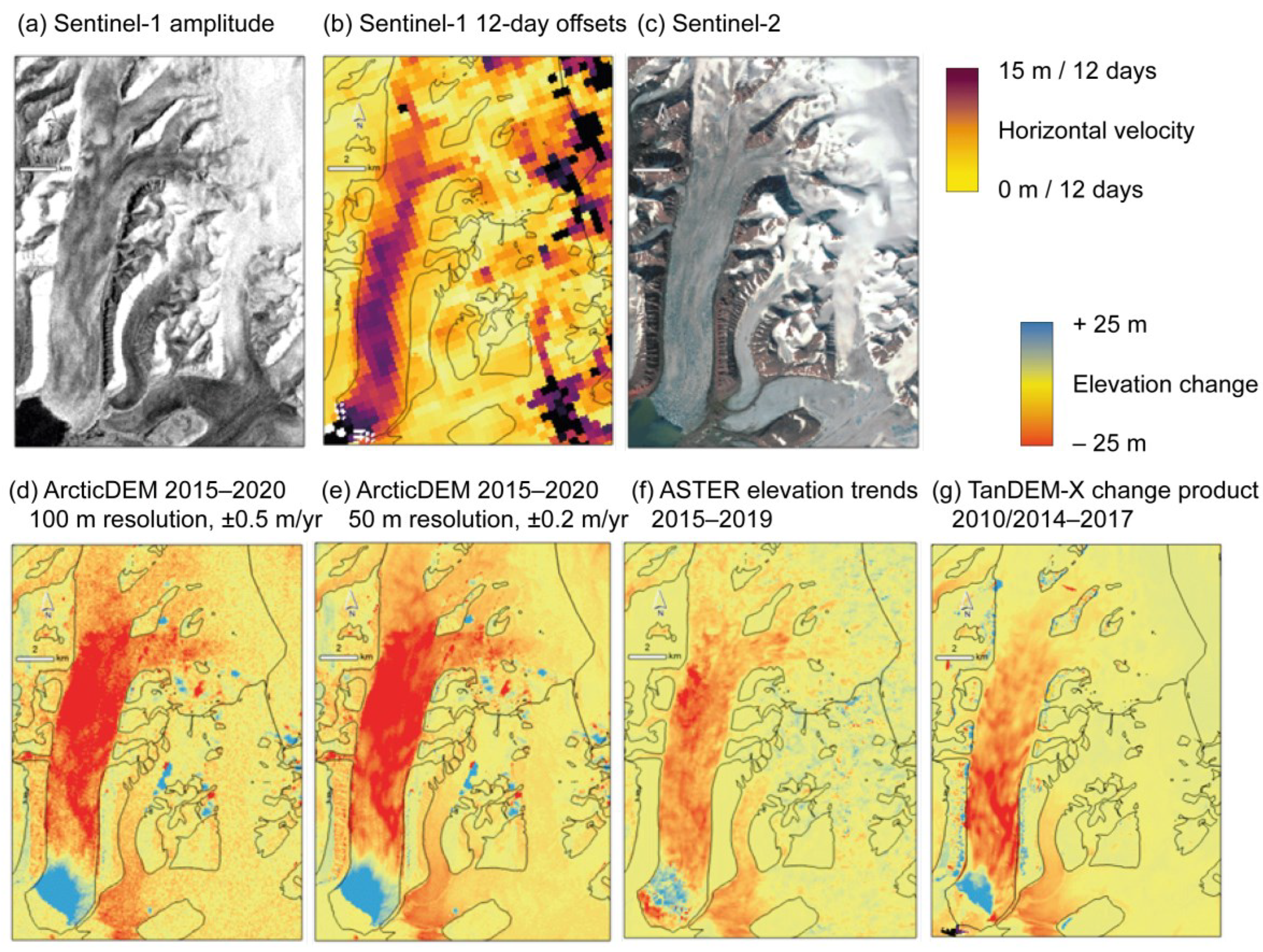
| Elevation changes over 5 years | Cross-track interferometry | Stacks of DEMs with 12-day repeat | 1 + 5 | 100 × 100 m2 ± 0.5 m/yr (threshold, T) 50 × 50 m2 ± 0.2 m/yr (goal, G; 30 × 30 m2 for permafrost) | Glaciers, ice-sheet margins, permafrost |
| Seasonal elevation changes | Cross-track interferometry | Stacks of DEMs with 12-day repeat | 1 + 5 | “ | Glaciers, ice-sheet margins, landslides |
| Simultaneous elevation changes and lateral displacements | Cross-track interferometry; combined with offset tracking | Stacks of DEMs with 12-day repeat + lateral offsets between repeat SAR data | 1 + 5 (displacements only: 2–4) | “ | Glaciers, ice-sheet margins, landslides |
| Three-dimensional surface deformation | Stereo; using repeat-pass interferometry | 12-day line-of-sight displacements in multiple directions | 1–5, with larger LoS-diversity during 2–4 | 100 × 100 m2 ± 5% (threshold, T) 30 × 30 m2 ± 3% m/yr (goal, G) | Glaciers and ice sheets outside melting season; permafrost, rock glaciers, slow landslides |

- give new insights into the coupling between glacier mass change and ice dynamics, and through that, improve understanding of rapid glacier changes, and the balance between three-dimensional ice motion and mass accumulation/ablation (Section 5.1).
- provide large-area information on the spatial distribution, extent, and magnitude of heave/subsidence and erosion in permafrost areas (Section 5.2).
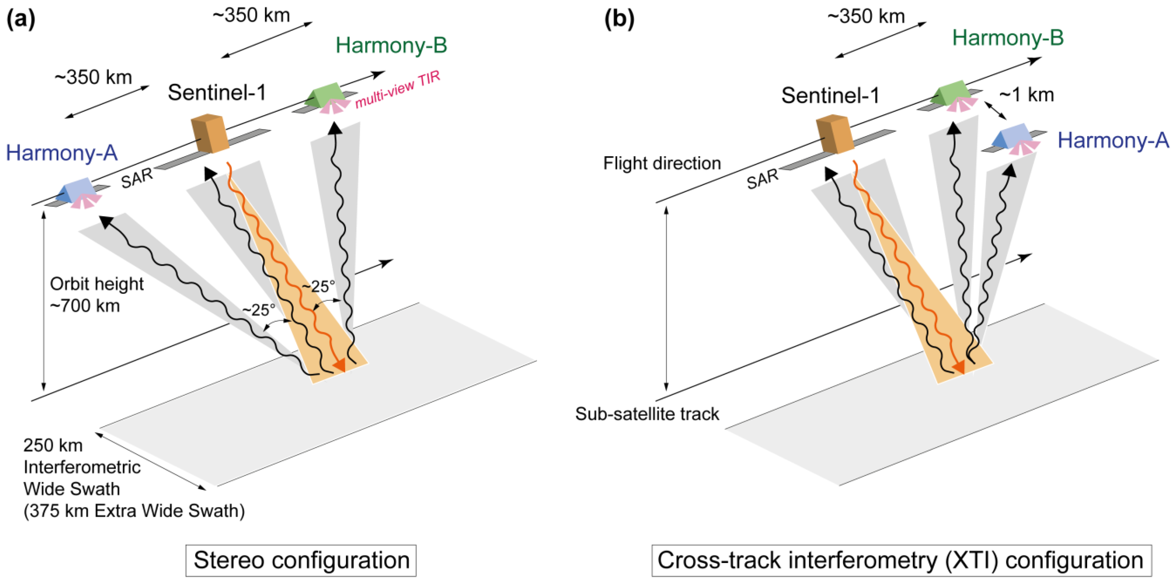
2. Mission Concept
- A “stereo” configuration, optimized for the measurement of motion vectors, where each Harmony satellite is positioned on either side in the along-track direction of Sentinel-1 with a separation distance in the order of 300–400 km (to be optimized for performance but kept constant in orbit) (Figure 2a).
- An “across-track interferometry” (XTI) configuration, optimized for the single-pass interferometric measurement of time series of surface topography, where one of the Harmony satellites will be positioned in a close formation (several hundred meters cross-track separation; baseline) with the other Harmony satellite, similar to the TanDEM-X mission (Figure 2b). Additionally, in this phase, the along-track separation distance between the close XTI-formation of both Harmony satellites and Sentinel-1 will remain in the order of 300–400 km.
3. Global Multi-Year Glacier Elevation Changes
3.1. Glacier DEMs
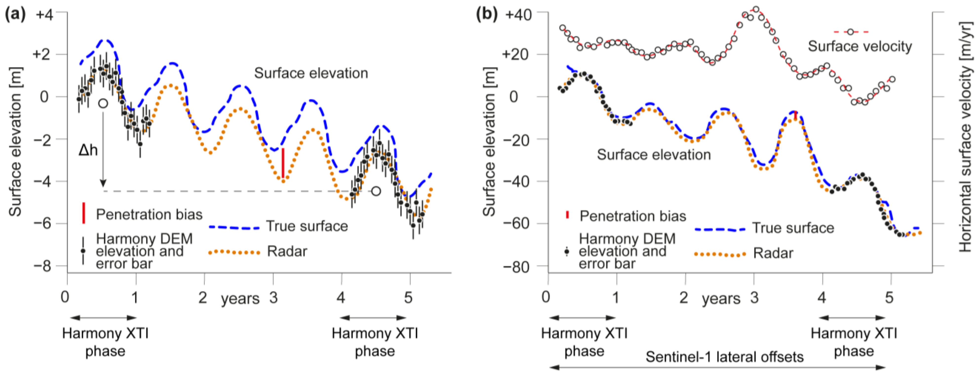
3.2. Penetration Bias in DEMs
- estimation of the penetration length from the interferometric coherence according to Dall [35] and computation of the associated DEM and geolocation bias;
- comparison of interferometric DEMs from different incidence angles. The penetration length and the resulting DEM bias are dependent on the radar incidence angle. For stable snow and firn conditions and thus stable penetration bias (which in turn can be assessed from radar backscatter), penetration bias can be estimated from overlapping DEMs acquired from neighboring orbits. This method will not be available everywhere and at any time but could provide spatio-temporal samples of elevation biases to complement the other approaches;
- the two full-year time series of roughly bi-weekly DEMs from the same reference orbit (Figure 3a), and more frequent DEMs when combining DEMs from ascending and descending and neighboring orbits, can not only be used to increase elevation accuracy by DEM stacking, but also to analyze the seasonal cycle and weather dependence of elevation bias, for instance, by identifying sudden elevation jumps in space and time due to changes in penetration. The impact of radar penetration bias on Harmony’s 5-year elevation changes can be reduced by selecting similar snow and firn conditions, and thus similar penetration conditions, in the DEM time series of both years 1 and 5. In principle, the elevation differences between the DEM stacks of years 1 and 5 are not fully affected by elevation bias due to penetration but only the (smaller) differential bias between these two years.
4. Sub-Seasonal Elevation Changes and Simultaneous Glacier Velocities
5. Three-Dimensional Surface Velocities
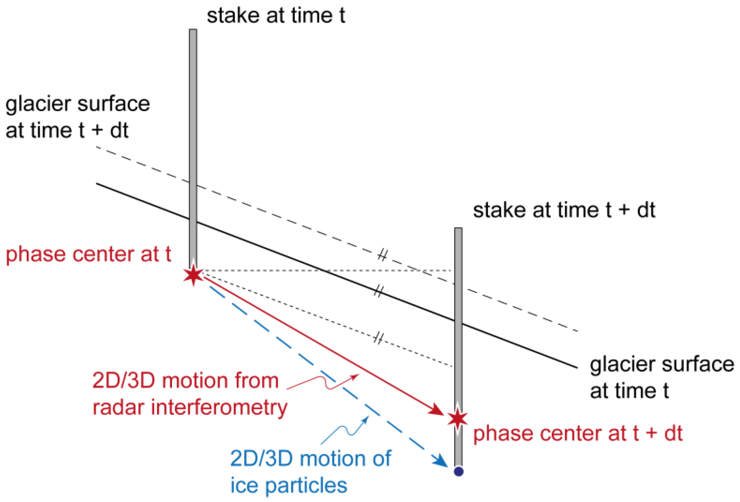
5.1. Submergence, Emergence, and Short-Term Deformations at Glacier Surface
5.2. Permafrost Ground Motion and Elevation Changes
5.3. Periglacial and Paraglacial Landslides
6. Multistatic Backscatter
7. Conclusions
Author Contributions
Funding
Data Availability Statement
Acknowledgments
Conflicts of Interest
References
- Rott, H. Advances in interferometric synthetic aperture radar (insar) in earth system science. Prog. Phys. Geogr. 2009, 33, 769–791. [Google Scholar] [CrossRef]
- Strozzi, T.; Paul, F.; Wiesmann, A.; Schellenberger, T.; Kääb, A. Circum-arctic changes in the flow of glaciers and ice caps from satellite sar data between the 1990s and 2017. Remote Sens. 2017, 9, 947. [Google Scholar] [CrossRef]
- Strozzi, T.; Caduff, R.; Jones, N.; Barboux, C.; Delaloye, R.; Bodin, X.; Kaab, A.; Matzler, E.; Schrott, L. Monitoring rock glacier kinematics with satellite synthetic aperture radar. Remote Sens. 2020, 12, 559. [Google Scholar] [CrossRef]
- Mouginot, J.; Rignot, E.; Bjork, A.A.; van den Broeke, M.; Millan, R.; Morlighem, M.; Noël, B.; Scheuchl, B.; Wood, M. Forty-six years of greenland ice sheet mass balance from 1972 to 2018. Proc. Natl. Acad. Sci. USA 2019, 116, 9239–9244. [Google Scholar] [CrossRef] [PubMed]
- Mouginot, J.; Rignot, E.; Scheuchl, B. Continent-wide, interferometric sar phase, mapping of antarctic ice velocity. Geophys. Res. Lett. 2019, 46, 9710–9718. [Google Scholar] [CrossRef]
- Friedl, P.; Weiser, F.; Fluhrer, A.; Braun, M.H. Remote sensing of glacier and ice sheet grounding lines: A review. Earth-Sci. Rev. 2020, 201, 102948. [Google Scholar] [CrossRef]
- Bhattacharjee, S.; Garg, R.D. Estimation of sea ice drift and concentration during melt season using c-band dual-polarimetric sentinel-1 data. Remote Sens. Appl. 2024, 33, 101104. [Google Scholar] [CrossRef]
- Dammann, D.O.; Eicken, H.; Meyer, F.J.; Mahoney, A.R. Assessing small-scale deformation and stability of landfast sea ice on seasonal timescales through l-band sar interferometry and inverse modeling. Remote Sens. Environ. 2016, 187, 492–504. [Google Scholar] [CrossRef]
- Guneriussen, T.; Hogda, K.A.; Johnsen, H.; Lauknes, I. Insar for estimation of changes in snow water equivalent of dry snow. IEEE Trans. Geosci. Remote 2001, 39, 2101–2108. [Google Scholar] [CrossRef]
- Nagler, T.; Rott, H.; Ripper, E.; Bippus, G.; Hetzenecker, M. Advancements for snowmelt monitoring by means of sentinel-1 sar. Remote Sens. 2016, 8, 348. [Google Scholar] [CrossRef]
- Lievens, H.; Brangers, I.; Marshall, H.P.; Jonas, T.; Olefs, M.; De Lannoy, G. Sentinel-1 snow depth retrieval at sub-kilometer resolution over the european alps. Cryosphere 2022, 16, 159–177. [Google Scholar] [CrossRef]
- Lund, J.; Forster, R.R.; Deeb, E.J.; Liston, G.E.; Skiles, S.M.; Marshall, H.P. Interpreting sentinel-1 sar backscatter signals of snowpack surface melt/freeze, warming, and ripening, through field measurements and physically-based snowmodel. Remote Sens. 2022, 14, 4002. [Google Scholar] [CrossRef]
- Strozzi, T.; Antonova, S.; Gunther, F.; Matzler, E.; Vieira, G.; Wegmuller, U.; Westermann, S.; Bartsch, A. Sentinel-1 sar interferometry for surface deformation monitoring in low-land permafrost areas. Remote Sens. 2018, 10, 1360. [Google Scholar] [CrossRef]
- Bernhard, P.; Zwieback, S.; Leinss, S.; Hajnsek, I. Mapping retrogressive thaw slumps using single-pass tandem-x observations. IEEE J.-Stars. 2020, 13, 3263–3280. [Google Scholar] [CrossRef]
- López-Dekker, P.; Krieger, G.; Moreira, A. Multistatic radar systems. In Distributed Space Missions for Earth System Monitoring; D’Errico, M., Ed.; Springer: New York, NY, USA, 2013; pp. 61–122. [Google Scholar]
- Van Zyl, J.J. The shuttle radar topography mission (srtm): A breakthrough in remote sensing of topography. Acta Astronaut. 2001, 48, 559–565. [Google Scholar] [CrossRef]
- Zink, M.; Moreira, A.; Hajnsek, I.; Rizzoli, P.; Bachmann, M.; Kahle, R.; Fritz, T.; Huber, M.; Krieger, G.; Lachaise, M.; et al. Tandem-x: 10 years of formation flying bistatic sar interferometry. IEEE J.-Stars. 2021, 14, 3546–3565. [Google Scholar] [CrossRef]
- ESA. Report for Mission Selection: Earth Explorer 10 Candidate Mission Harmony; ESA: Noordwijk, The Netherlands, 2022; p. 369. [Google Scholar]
- ESA. Esa’s Living Planet Programme: Scientific Achievements and Future Challenges—Scientific Context of the Earth Observation Science Strategy for Esa (esa sp-1329/2, February 2015); ESA: Noordwijk, The Netherlands, 2015; p. 67. [Google Scholar]
- Theodosiou, A.; Kleinherenbrink, M.; López-Dekker, P. Wide-swath ocean altimetry using multisatellite single-pass interferometry. IEEE Trans. Geosci. Remote 2023, 61, 5210721. [Google Scholar] [CrossRef]
- Kleinherenbrink, M.; Korosov, A.; Newman, T.; Theodosiou, A.; Komarov, A.S.; Li, Y.H.; Mulder, G.; Rampal, P.; Stroeve, J.; Lopez-Dekker, P. Estimating instantaneous sea-ice dynamics from space using the bi-static radar measurements of earth explorer 10 candidate harmony. Cryosphere 2021, 15, 3101–3118. [Google Scholar] [CrossRef]
- Berthier, E.; Floriciou, D.; Gardner, A.S.; Gourmelen, N.; Jakob, L.; Paul, F.; Treichler, D.; Wouters, B.; Belart, J.M.C.; Dehecq, A.; et al. Measuring glacier mass changes from space—A review. Rep. Prog. Phys. 2023, 86, 036801. [Google Scholar] [CrossRef]
- Zemp, M.; Huss, M.; Thibert, E.; Eckert, N.; McNabb, R.; Huber, J.; Barandun, M.; Machguth, H.; Nussbaumer, S.U.; Gartner-Roer, I.; et al. Global glacier mass changes and their contributions to sea-level rise from 1961 to 2016. Nature 2019, 568, 382–386. [Google Scholar]
- Hugonnet, R.; McNabb, R.; Berthier, E.; Menounos, B.; Nuth, C.; Girod, L.; Farinotti, D.; Huss, M.; Dussaillant, I.; Brun, F.; et al. Accelerated global glacier mass loss in the early twenty-first century. Nature 2021, 592, 726–731. [Google Scholar] [CrossRef] [PubMed]
- Kääb, A.; Berthier, E.; Nuth, C.; Gardelle, J.; Arnaud, Y. Contrasting patterns of early twenty-first-century glacier mass change in the himalayas. Nature 2012, 488, 495–498. [Google Scholar] [CrossRef] [PubMed]
- McMillan, M.; Shepherd, A.; Muir, A.; Gaudelli, J.; Hogg, A.E.; Cullen, R. Assessment of cryosat-2 interferometric and non-interferometric sar altimetry over ice sheets. Adv. Space Res. 2018, 62, 1281–1291. [Google Scholar] [CrossRef]
- Morris, A.; Moholdt, G.; Gray, L. Spread of svalbard glacier mass loss to barents sea margins revealed by cryosat-2. J. Geophys. Res.-Earth 2020, 125, e2019JF005357. [Google Scholar] [CrossRef]
- Jakob, L.; Gourmelen, N.; Ewart, M.; Plummer, S. Spatially and temporally resolved ice loss in high mountain asia and the gulf of alaska observed by cryosat-2 swath altimetry between 2010 and 2019. Cryosphere 2021, 15, 1845–1862. [Google Scholar] [CrossRef]
- Porter, C.; Howat, I.; Noh, M.-J.; Husby, E.; Khuvis, S.; Danish, E.; Tomko, K.; Gardiner, J.; Negrete, A.; Yadav, B.; et al. Arcticdem—Strips, Version 4.1, 6th ed.; Polar Geospatial, C., Ed.; Harvard Dataverse: Cambridge, MA, USA, 2022. [Google Scholar]
- Dall, J.; Madsen, S.N.; Keller, K.; Forsberg, R. Topography and penetration of the greenland ice sheet measured with airborne sar interferometry. Geophys. Res. Lett. 2001, 28, 1703–1706. [Google Scholar] [CrossRef]
- Rignot, E.; Echelmeyer, K.; Krabill, W. Penetration depth of interferometric synthetic-aperture radar signals in snow and ice. Geophys. Res. Lett. 2001, 28, 3501–3504. [Google Scholar] [CrossRef]
- Gardelle, J.; Berthier, E.; Arnaud, Y. Impact of resolution and radar penetration on glacier elevation changes computed from multi-temporal dems. J. Glaciol. 2012, 58, 419–422. [Google Scholar] [CrossRef]
- Rott, H.; Scheiblauer, S.; Wuite, J.; Krieger, L.; Floricioiu, D.; Rizzoli, P.; Libert, L.; Nagler, T. Penetration of interferometric radar signals in antarctic snow. Cryosphere 2021, 15, 4399–4419. [Google Scholar] [CrossRef]
- Benedikter, A.; Rodriguez-Cassola, M.; Prats-Iraola, P.; Krieger, G.; Fischer, G. On the processing of single-pass insar data for accurate elevation measurements of ice sheets and glaciers. IEEE Trans. Geosci. Remote 2024, 62, 4300310. [Google Scholar] [CrossRef]
- Dall, J. Insar elevation bias caused by penetration into uniform volumes. IEEE Trans. Geosci. Remote 2007, 45, 2319–2324. [Google Scholar] [CrossRef]
- Nolan, M.; Larsen, C.; Sturm, M. Mapping snow depth from manned aircraft on landscape scales at centimeter resolution using structure-from-motion photogrammetry. Cryosphere 2015, 9, 1445–1463. [Google Scholar] [CrossRef]
- Treichler, D.; Kaab, A. Snow depth from icesat laser altimetry—A test study in southern norway. Remote Sens. Environ. 2017, 191, 389–401. [Google Scholar] [CrossRef]
- Deschamps-Berger, C.; Gascoin, S.; Berthier, E.; Deems, J.; Gutmann, E.; Dehecq, A.; Shean, D.; Dumont, M. Snow depth mapping from stereo satellite imagery in mountainous terrain: Evaluation using airborne laser-scanning data. Cryosphere 2020, 14, 2925–2940. [Google Scholar] [CrossRef]
- Kääb, A.; Leinss, S.; Gilbert, A.; Buhler, Y.; Gascoin, S.; Evans, S.G.; Bartelt, P.; Berthier, E.; Brun, F.; Chao, W.A.; et al. Massive collapse of two glaciers in western tibet in 2016 after surge-like instability. Nat. Geosci. 2018, 11, 114–120. [Google Scholar] [CrossRef]
- Kääb, A.; Jacquemart, M.; Gilbert, A.; Leinss, S.; Girod, L.; Huggel, C.; Falaschi, D.; Ugalde, F.; Petrakov, D.; Chernomorets, S.; et al. Sudden large-volume detachments of low-angle mountain glaciers. More frequent than thought? Cryosphere 2021, 15, 1751–1785. [Google Scholar] [CrossRef]
- Guillet, G.; King, O.; Lv, M.Y.; Ghuffar, S.; Benn, D.; Quincey, D.; Bolch, T. A regionally resolved inventory of high mountain asia surge-type glaciers, derived from a multi-factor remote sensing approach. Cryosphere 2022, 16, 603–623. [Google Scholar] [CrossRef]
- Kääb, A.; Girod, L. Brief communication: Rapid ∼ 335 x 10m bed erosionafter detachment of the sedongpu glacier (tibet). Cryosphere 2023, 17, 2533–2541. [Google Scholar] [CrossRef]
- Joughin, I.; Shean, D.E.; Smith, B.E.; Floricioiu, D. A decade of variability on jakobshavn isbrae: Ocean temperatures pace speed through influence on melange rigidity. Cryosphere 2020, 14, 211–227. [Google Scholar] [CrossRef]
- Mouginot, J.; Rignot, E.; Scheuchl, B. Sustained increase in ice discharge fromthe amundsen sea embayment, west antarctica, from1973 to 2013. Geophys. Res. Lett. 2014, 41, 1576–1584. [Google Scholar] [CrossRef]
- Mankoff, K.D.; Colgan, W.; Solgaard, A.; Karlsson, N.B.; Ahlstrom, A.P.; van As, D.; Box, J.E.; Khan, S.A.; Kjeldsen, K.K.; Mouginot, J.; et al. Greenland ice sheet solid ice discharge from 1986 through 2017. Earth Syst. Sci. Data 2019, 11, 769–786. [Google Scholar] [CrossRef]
- Rignot, E.; Mouginot, J.; Scheuchl, B.; van den Broeke, M.; van Wessem, M.J.; Morlighem, M. Four decades of antarctic ice sheet mass balance from 1979–2017. Proc. Natl. Acad. Sci. USA 2019, 116, 1095–1103. [Google Scholar] [CrossRef] [PubMed]
- King, M.D.; Howat, I.M.; Candela, S.G.; Noh, M.J.; Jeong, S.; Noël, B.P.Y.; van den Broeke, M.R.; Wouters, B.; Negrete, A. Dynamic ice loss from the greenland ice sheet driven by sustained glacier retreat. Commun. Earth Environ. 2020, 1, 1. [Google Scholar] [CrossRef]
- Wendt, A.; Mayer, C.; Lambrecht, A.; Floricioiu, D. A glacier surge of bivachny glacier, pamir mountains, observed by a time series of high-resolution digital elevation models and glacier velocities. Remote Sens. 2017, 9, 388. [Google Scholar] [CrossRef]
- Samsonov, S.; Tiampo, K.; Cassotto, R. Sar-derived flow velocity and its link to glacier surface elevation change and mass balance. Remote Sens. Environ. 2021, 258, 112343. [Google Scholar] [CrossRef]
- Samsonov, S.; Tiampo, K.; Cassotto, R. Measuring the state and temporal evolution of glaciers in alaska and yukon using synthetic-aperture-radar-derived (sar-derived) 3d time series of glacier surface flow. Cryosphere 2021, 15, 4221–4239. [Google Scholar] [CrossRef]
- Nagler, T.; Rott, H.; Hetzenecker, M.; Scharrer, K.; Magnússon, E.; Floricioiu, D.; Notarnicola, C. Retrieval of 3d-glacier movement by high resolution x-band sar data. In Proceedings of the 2012 IEEE International Geoscience and Remote Sensing Symposium, Munich, Germany, 22–27 July 2012; pp. 3233–3236. [Google Scholar]
- Joughin, I.R.; Kwok, R.; Fahnestock, M.A. Interferometric estimation of three-dimensional ice-flow using ascending and descending passes. IEEE Trans. Geosci. Remote 1998, 36, 25–37. [Google Scholar] [CrossRef]
- Gray, L. Using multiple radarsat insar pairs to estimate a full three-dimensional solution for glacial ice movement. Geophys. Res. Lett. 2011, 38, L05502. [Google Scholar] [CrossRef]
- Andersen, J.K.; Rathmann, N.; Hvidberg, C.S.; Grinsted, A.; Kusk, A.; Boncori, J.P.M.; Mouginot, J. Episodic subglacial drainage cascades below the northeast greenland ice stream. Geophys. Res. Lett. 2023, 50, e2023GL103240. [Google Scholar] [CrossRef]
- Maier, N.; Andersen, J.K.; Mouginot, J.; Gimbert, F.; Gagliardini, O. Wintertime supraglacial lake drainage cascade triggers large-scale ice flow response in greenland. Geophys. Res. Lett. 2023, 50, e2022GL102251. [Google Scholar] [CrossRef]
- Magnússon, E.; Björnsson, H.; Rott, H.; Pálsson, F. Reduced glacier sliding caused by persistent drainage from a subglacial lake. Cryosphere 2010, 4, 13–20. [Google Scholar] [CrossRef]
- Reeh, N.; Mohr, J.J.; Madsen, S.N.; Oerter, H.; Gundestrup, N.S. Three-dimensional surface velocities of storstrommen glacier, greenland, derived from radar interferometry and ice-sounding radar measurements. J. Glaciol. 2003, 49, 201–209. [Google Scholar] [CrossRef]
- Gudmundsson, S.; Sigmundsson, F.; Carstensen, J.M. Three-dimensional surface motion maps estimated from combined interferometric synthetic aperture radar and gps data. J. Geophys. Res.-Solid. Earth 2002, 107, 2250. [Google Scholar] [CrossRef]
- Magnússon, E.; Rott, H.; Björnsson, H.; Pálsson, F. The impact of jokulhlaups on basal sliding observed by sar interferometry on vatnajokull, iceland. J. Glaciol. 2007, 53, 232–240. [Google Scholar] [CrossRef]
- Schaefer, K.; Liu, L.; Parsekian, A.; Jafarov, E.; Chen, A.; Zhang, T.J.; Gusmeroli, A.; Panda, S.; Zebker, H.A.; Schaefer, T. Remotely sensed active layer thickness (resalt) at barrow, alaska using interferometric synthetic aperture radar. Remote Sens. 2015, 7, 3735–3759. [Google Scholar] [CrossRef]
- Rouyet, L.; Lauknes, T.R.; Christiansen, H.H.; Strand, S.M.; Larsen, Y. Seasonal dynamics of a permafrost landscape, adventdalen, svalbard, investigated by insar. Remote Sens. Environ. 2019, 231, 111236. [Google Scholar] [CrossRef]
- Kääb, A.; Strozzi, T.; Bolch, T.; Caduff, R.; Trefall, H.; Stoffel, M.; Kokarev, A. Inventory and changes of rock glacier creep speeds in ile alatau and kungöy ala-too, northern tien shan, since the 1950s. Cryosphere 2021, 15, 927–949. [Google Scholar] [CrossRef]
- Bertone, A.; Barboux, C.; Bodin, X.; Bolch, T.; Brardinoni, F.; Caduff, R.; Christiansen, H.H.; Darrow, M.M.; Delaloye, R.; Etzelmüller, B.; et al. Incorporating insar kinematics into rock glacier inventories: Insights from 11 regions worldwide. Cryosphere 2022, 16, 2769–2792. [Google Scholar] [CrossRef]
- Ballantyne, C.K. Paraglacial geomorphology. Quat. Sci. Rev. 2002, 21, 1935–2017. [Google Scholar] [CrossRef]
- Kääb, A. Remote sensing of permafrost-related problems and hazards. Permafr. Periglac. 2008, 19, 107–136. [Google Scholar] [CrossRef]
- McColl, S.T. Paraglacial rock-slope stability. Geomorphology 2012, 153, 1–16. [Google Scholar] [CrossRef]
- Cossart, É.; Mercier, D.; Decaulne, A.; Feuillet, T. An overview of the consequences of paraglacial landsliding on deglaciated mountain slopes: Typology, timing and contribution to cascading fluxes. Quaternaire 2013, 24, 13–24. [Google Scholar] [CrossRef]
- Kos, A.; Amann, F.; Strozzi, T.; Delaloye, R.; von Ruette, J.; Springman, S. Contemporary glacier retreat triggers a rapid landslide response, great aletsch glacier, switzerland. Geophys. Res. Lett. 2016, 43, 12466–12474. [Google Scholar] [CrossRef]
- Kääb, A. Remote Sensing of Mountain Glaciers and Permafrost Creep; University of Zurich: Zurich, Switzerland, 2005; Volume 48, p. 266. [Google Scholar]
- Strozzi, T.; Delaloye, R.; Kääb, A.; Ambrosi, C.; Perruchoud, E.; Wegmüller, U. Combined observations of rock mass movements using satellite sar interferometry, differential gps, airborne digital photogrammetry, and airborne photography interpretation. J. Geophys. Res.-Earth 2010, 115, F01014. [Google Scholar] [CrossRef]
- Raucoules, D.; de Michele, M.; Malet, J.P.; Ulrich, P. Time-variable 3d ground displacements from high-resolution synthetic aperture radar (sar). Application to la valette landslide (south french alps). Remote Sens. Environ. 2013, 139, 198–204. [Google Scholar] [CrossRef]
- Strozzi, T.; Ambrosi, C.; Raetzo, H. Interpretation of aerial photographs and satellite sar interferometry for the inventory of landslides. Remote Sens. 2013, 5, 2554–2570. [Google Scholar] [CrossRef]
- Strozzi, T.; Raetzo, H.; Wegmuller, U.; Papke, J.; Caduff, R.; Werner, C.; Wiesmann, A. Satellite and terrestrial radar interferometry for the measurement of slope deformation. In Engineering Geology for Society and Territory—Volume 5; Springer: Cham, Switzerland, 2015; pp. 161–165. [Google Scholar]
- Samsonov, S.; Dille, A.; Dewitte, O.; Kervyn, F.; d’Oreye, N. Satellite interferometry for mapping surface deformation time series in one, two and three dimensions: A new method illustrated on a slow-moving landslide. Eng. Geol. 2020, 266, 105471. [Google Scholar] [CrossRef]
- Fuhrmann, T.; Garthwaite, M.C. Resolving three-dimensional surface motion with insar: Constraints from multi-geometry data fusion. Remote Sens. 2019, 11, 241. [Google Scholar] [CrossRef]
- Renga, A.; Gigantino, A.; Graziano, M.D.; Moccia, A.; Fedele, A.; Natalucci, S. Design considerations and performance analysis for rodio distributed sar mission. Acta Astronaut. 2023, 210, 474–482. [Google Scholar] [CrossRef]
- Gigantino, A.; Renga, A.; Graziano, M.D.; Abbundo, C.; Ravellino, F.; Moccia, A.; di Martire, D.; Khalili, M.A.; Ramondini, M.; Pisacane, V.; et al. Long-baseline multistatic and bistatic sar products: Application to the rodio mission. Acta Astronaut. 2024, 222, 314–324. [Google Scholar] [CrossRef]
- Bordoni, F.; Younis, M.; Rodriguez-Cassola, M.; Prats-Iraola, P.; López-Dekker, P.; Krieger, G. Saocom-cs sar imaging performance evaluation in large baseline bistatic configuration. In Proceedings of the 2015 IEEE International Geoscience and Remote Sensing Symposium (IGARSS), Milan, Italy, 26–31 July 2015; pp. 2107–2110. [Google Scholar]
- Dubois-Fernandez, P.; Cantalloube, H.; Vaizan, B.; Krieger, G.; Horn, R.; Wendler, M.; Giroux, V. Onera-dlr bistatic sar campaign: Planning, data acquisition, and first analysis of bistatic scattering behaviour of natural and urban targets. IEE Proc.-Radar Sonar Navig. 2006, 153, 214–223. [Google Scholar] [CrossRef]
- Pierdicca, N.; Brogioni, M.; Fascetti, F.; Ouellette, J.D.; Guerriero, L. Retrieval of biogeophysical parameters from bistatic observations of land at l-band: A theoretical study. IEEE Trans. Geosci. Remote 2022, 60, 4402517. [Google Scholar] [CrossRef]
- Stefko, M.; Leinss, S.; Frey, O.; Hajnsek, I. Coherent backscatter enhancement in bistatic ku- and x-band radar observations of dry snow. Cryosphere 2022, 16, 2859–2879. [Google Scholar] [CrossRef]
- Deeb, E.J.; Forster, R.R.; Kane, D.L. Monitoring snowpack evolution using interferometric synthetic aperture radar on the north slope of alaska, USA. Int. J. Remote Sens. 2011, 32, 3985–4003. [Google Scholar] [CrossRef]
- Benedikter, A.; Belinska, K.; Rodriguez-Cassola, M.; Prats-Iraola, P.; Fischer, G.; Krieger, G.; Hajnsek, I. Towards dry snow parameter estimation by simultaneous multiple squint differential INSAR. IEEE Trans. Geosci. Remote. 2024; in press. [Google Scholar]


Disclaimer/Publisher’s Note: The statements, opinions and data contained in all publications are solely those of the individual author(s) and contributor(s) and not of MDPI and/or the editor(s). MDPI and/or the editor(s) disclaim responsibility for any injury to people or property resulting from any ideas, methods, instructions or products referred to in the content. |
© 2024 by the authors. Licensee MDPI, Basel, Switzerland. This article is an open access article distributed under the terms and conditions of the Creative Commons Attribution (CC BY) license (https://creativecommons.org/licenses/by/4.0/).
Share and Cite
Kääb, A.; Mouginot, J.; Prats-Iraola, P.; Rignot, E.; Rabus, B.; Benedikter, A.; Rott, H.; Nagler, T.; Rommen, B.; Lopez-Dekker, P. Potential of the Bi-Static SAR Satellite Companion Mission Harmony for Land-Ice Observations. Remote Sens. 2024, 16, 2918. https://doi.org/10.3390/rs16162918
Kääb A, Mouginot J, Prats-Iraola P, Rignot E, Rabus B, Benedikter A, Rott H, Nagler T, Rommen B, Lopez-Dekker P. Potential of the Bi-Static SAR Satellite Companion Mission Harmony for Land-Ice Observations. Remote Sensing. 2024; 16(16):2918. https://doi.org/10.3390/rs16162918
Chicago/Turabian StyleKääb, Andreas, Jérémie Mouginot, Pau Prats-Iraola, Eric Rignot, Bernhard Rabus, Andreas Benedikter, Helmut Rott, Thomas Nagler, Björn Rommen, and Paco Lopez-Dekker. 2024. "Potential of the Bi-Static SAR Satellite Companion Mission Harmony for Land-Ice Observations" Remote Sensing 16, no. 16: 2918. https://doi.org/10.3390/rs16162918
APA StyleKääb, A., Mouginot, J., Prats-Iraola, P., Rignot, E., Rabus, B., Benedikter, A., Rott, H., Nagler, T., Rommen, B., & Lopez-Dekker, P. (2024). Potential of the Bi-Static SAR Satellite Companion Mission Harmony for Land-Ice Observations. Remote Sensing, 16(16), 2918. https://doi.org/10.3390/rs16162918