Research on Jianghan Plain Water System Dynamics and Influences with Multiple Landsat Satellites
Abstract
1. Introduction
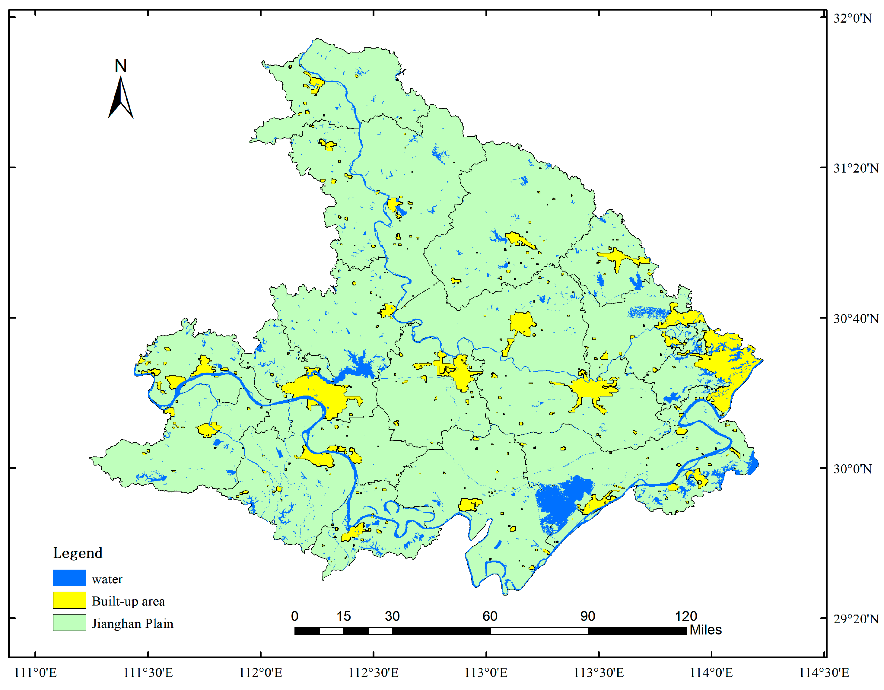
2. Study Area and Data Sources
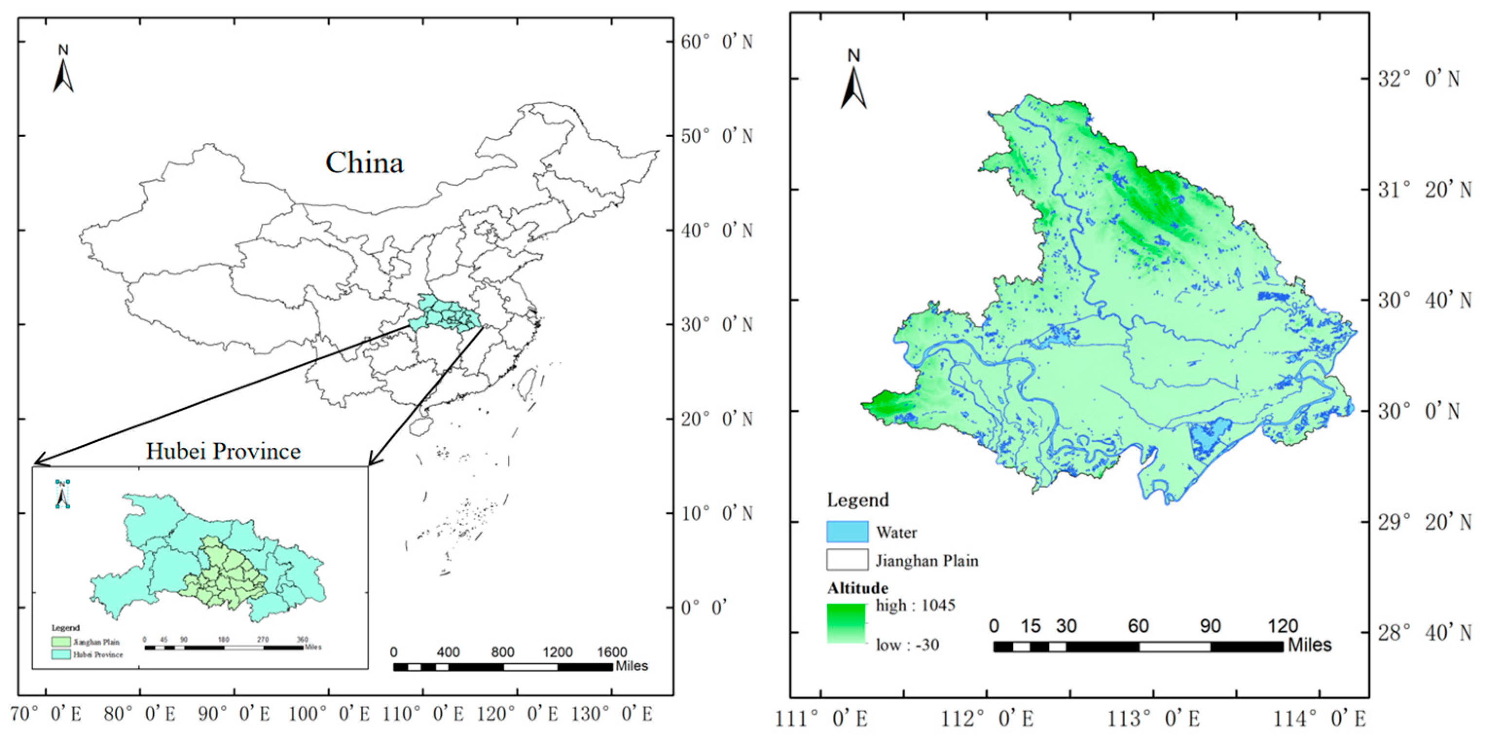
2.1. Overview of the Study Area
2.2. Data Sources and Preprocessing
2.2.1. Data Sources
2.2.2. Data Preprocessing
3. Methods
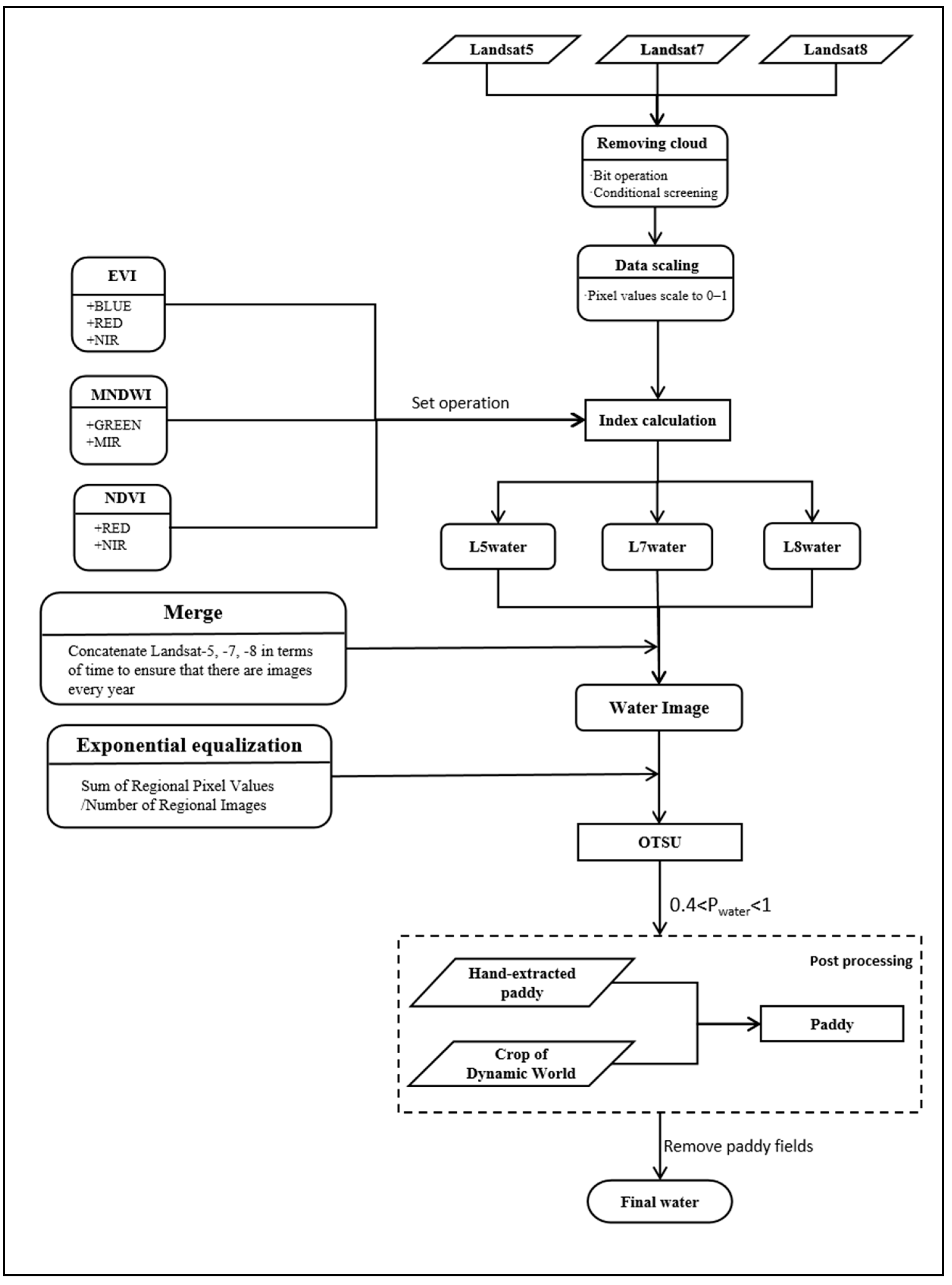
3.1. Water Body Extraction Based on Landsat 5/7/8 Multi-Index Fusion
3.2. The Calculation of Water Body Landscape Indices
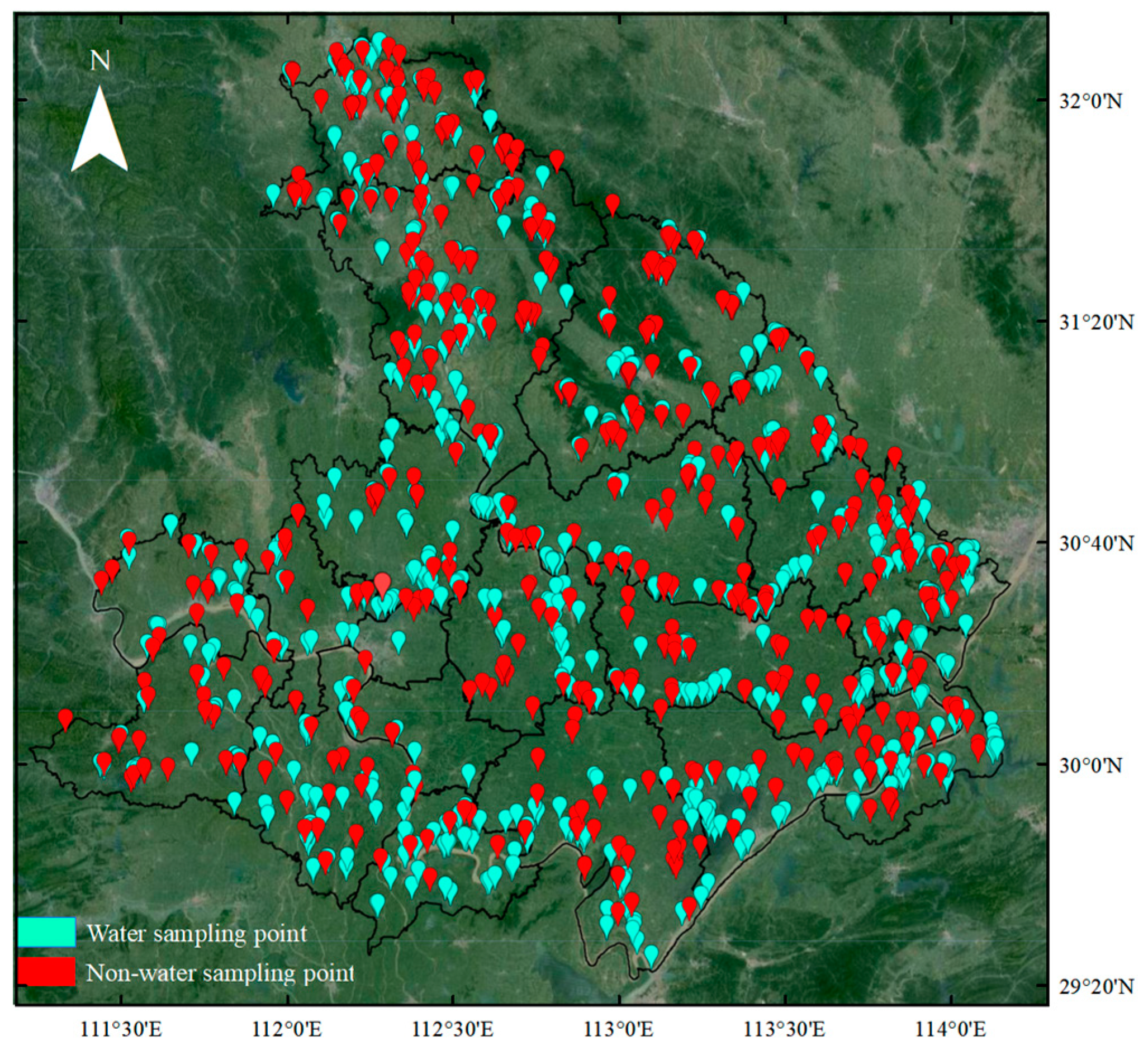
3.3. Validation of Water Body Extraction Data
3.3.1. Accuracy Evaluation Metrics
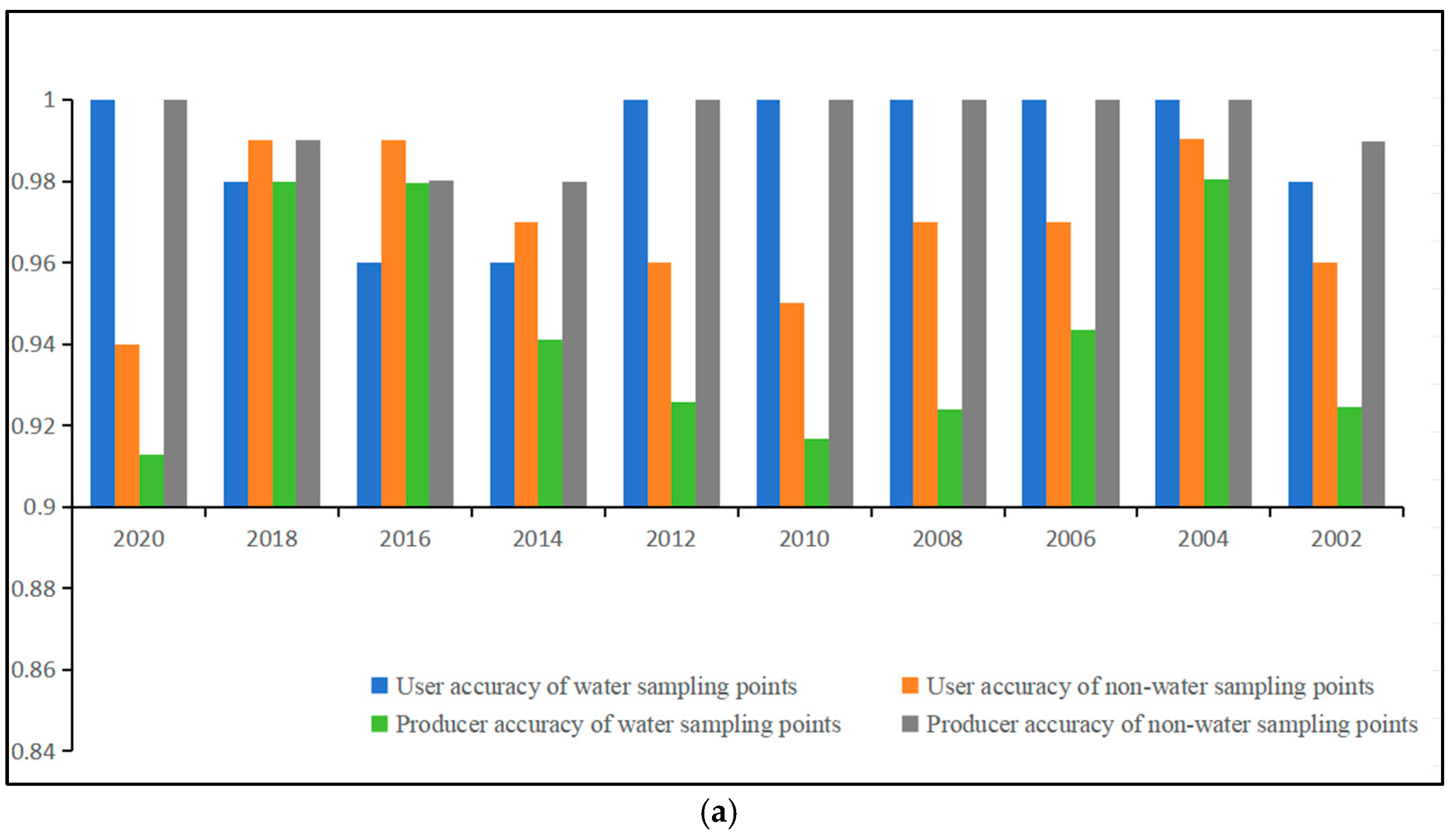
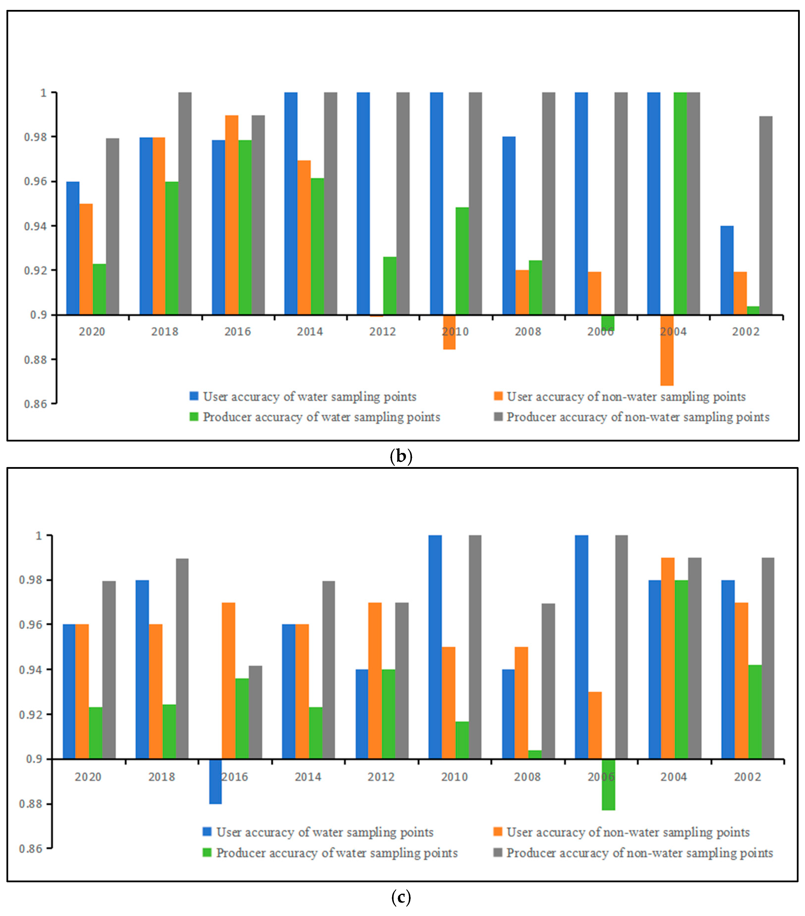
3.3.2. Accuracy Evaluation
4. Results and Analysis
4.1. Long-Term Water Landscape Indices in Jianghan Plain
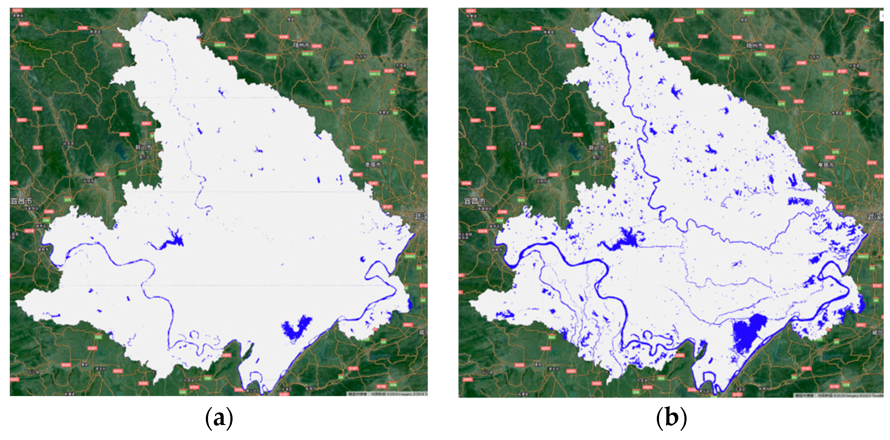
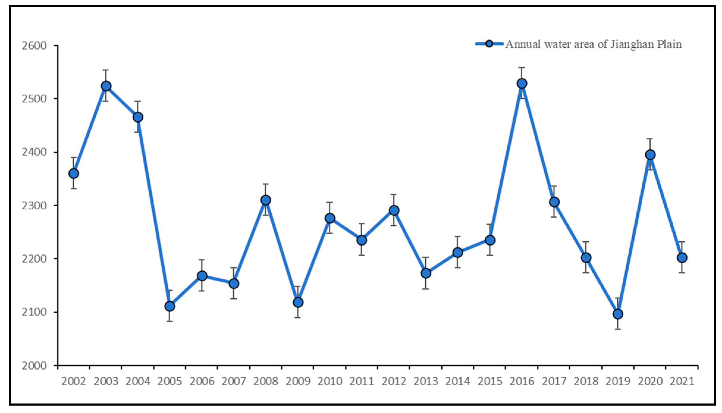
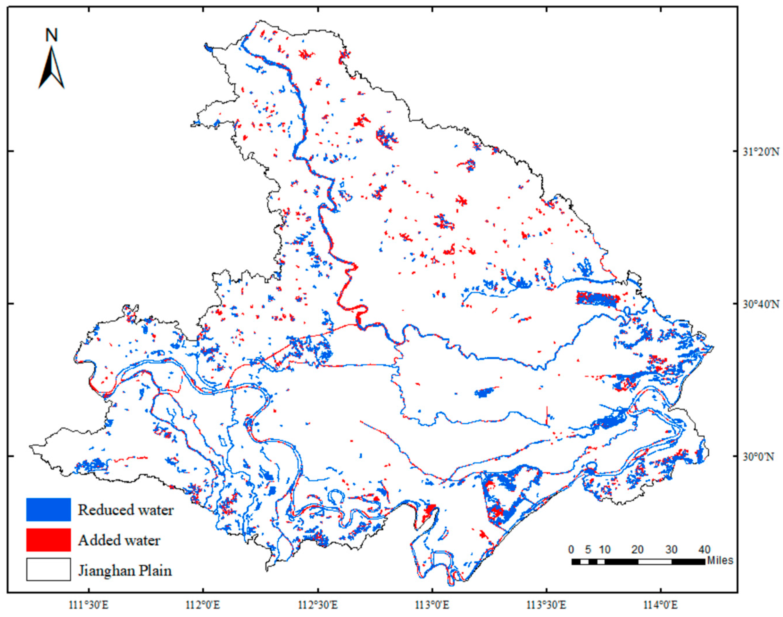
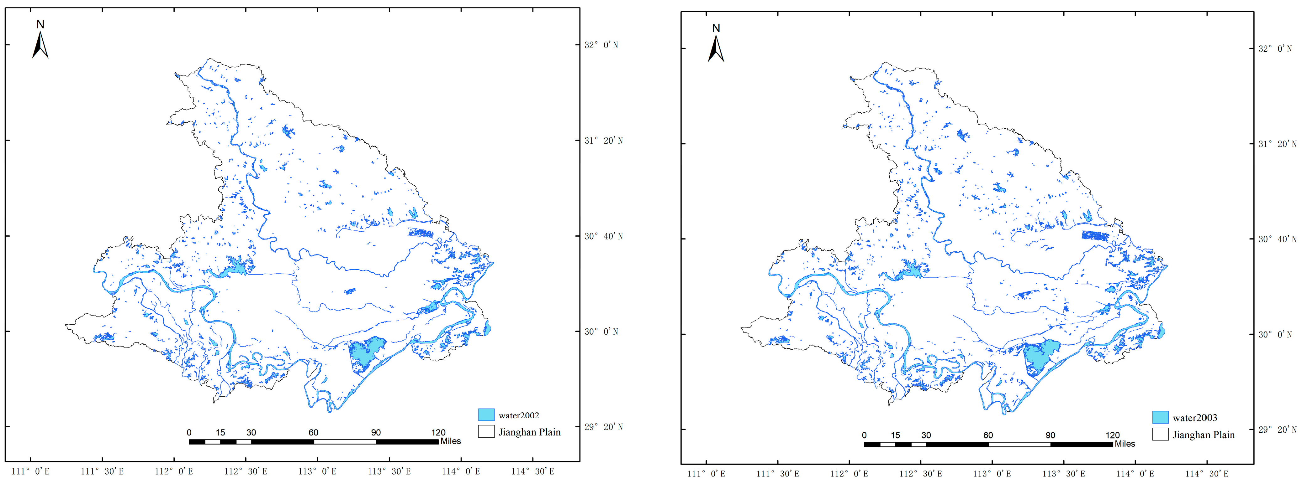
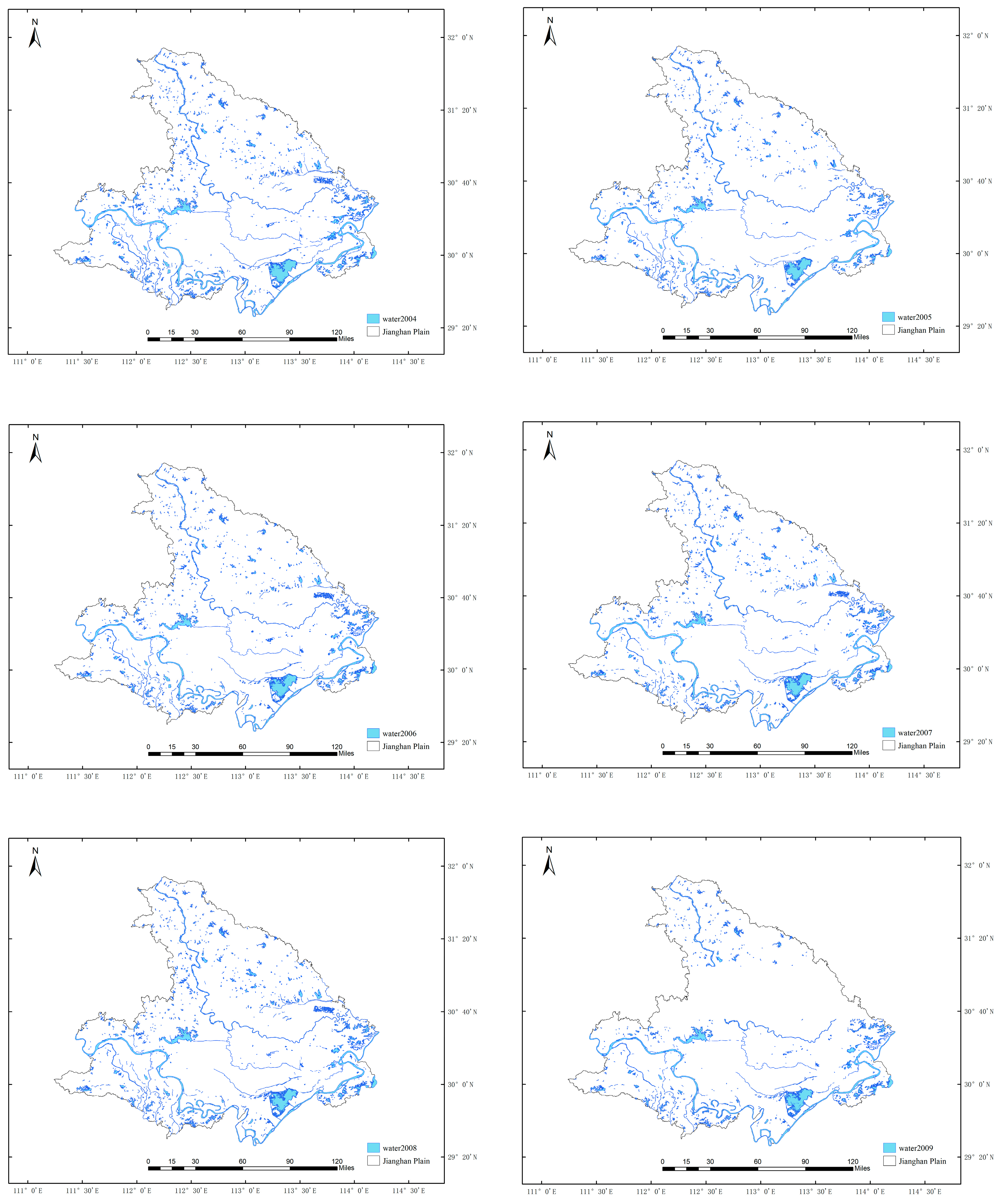
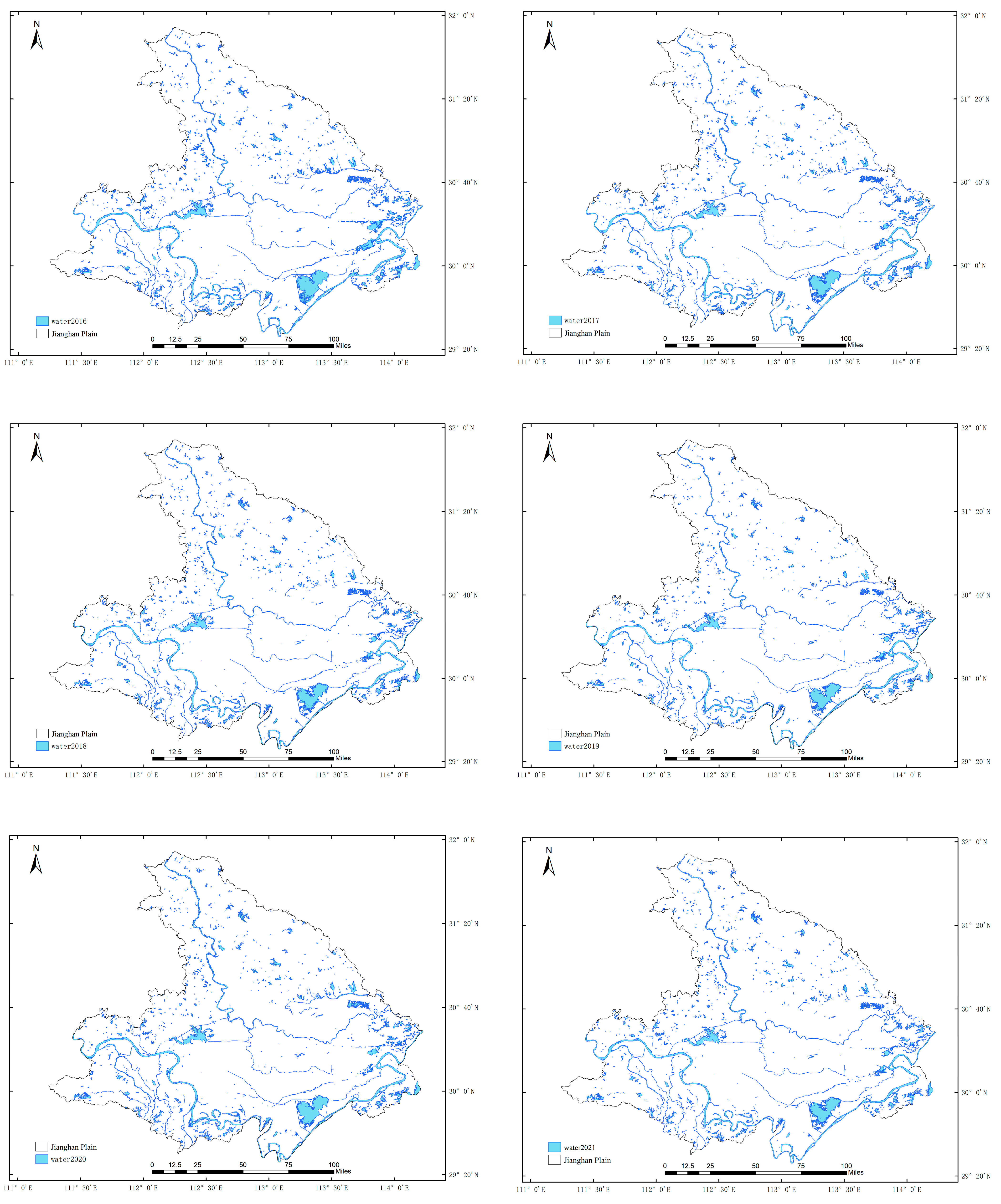
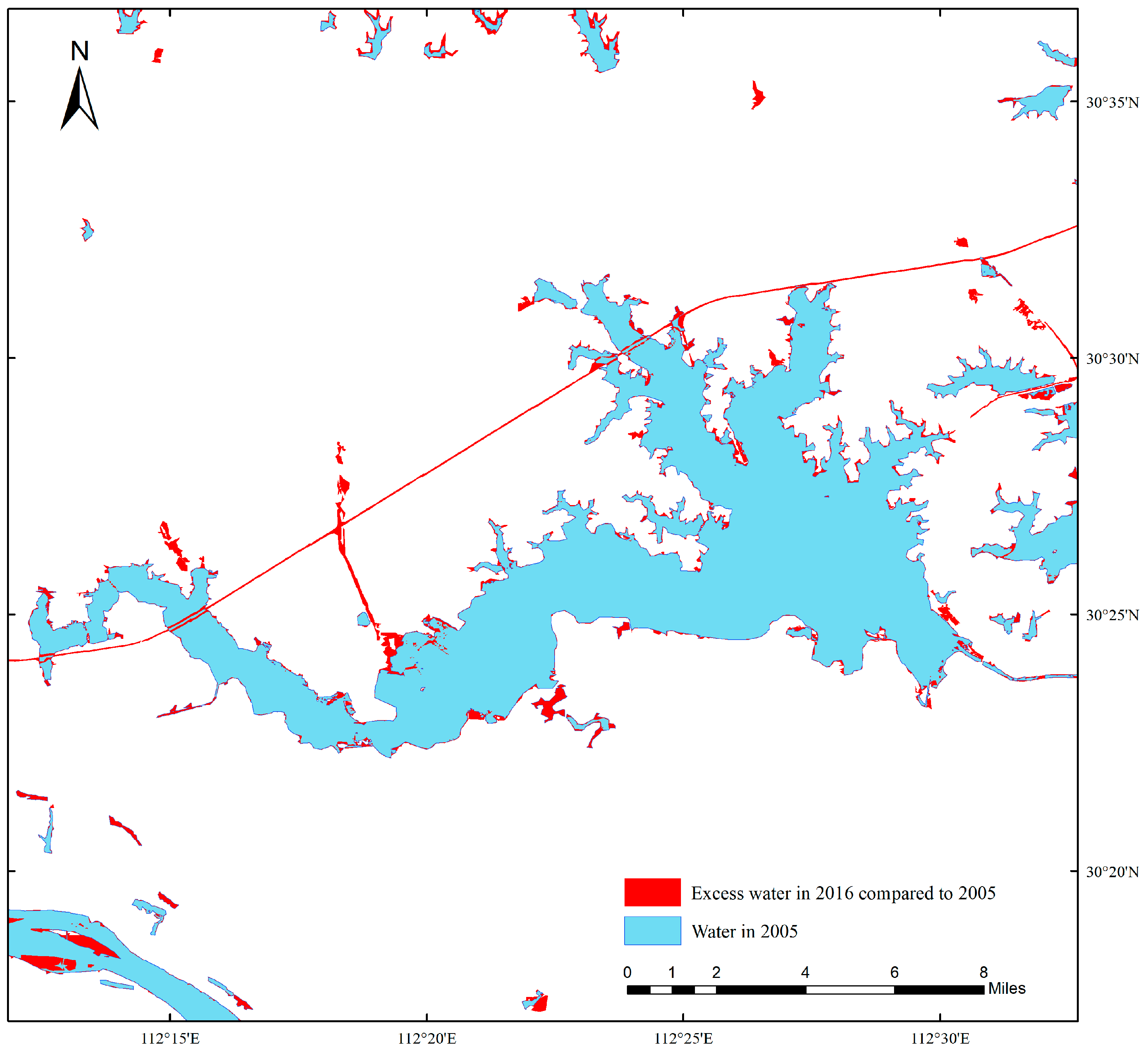
4.1.1. Spatio-Temporal Evolution Characteristics of the Water System
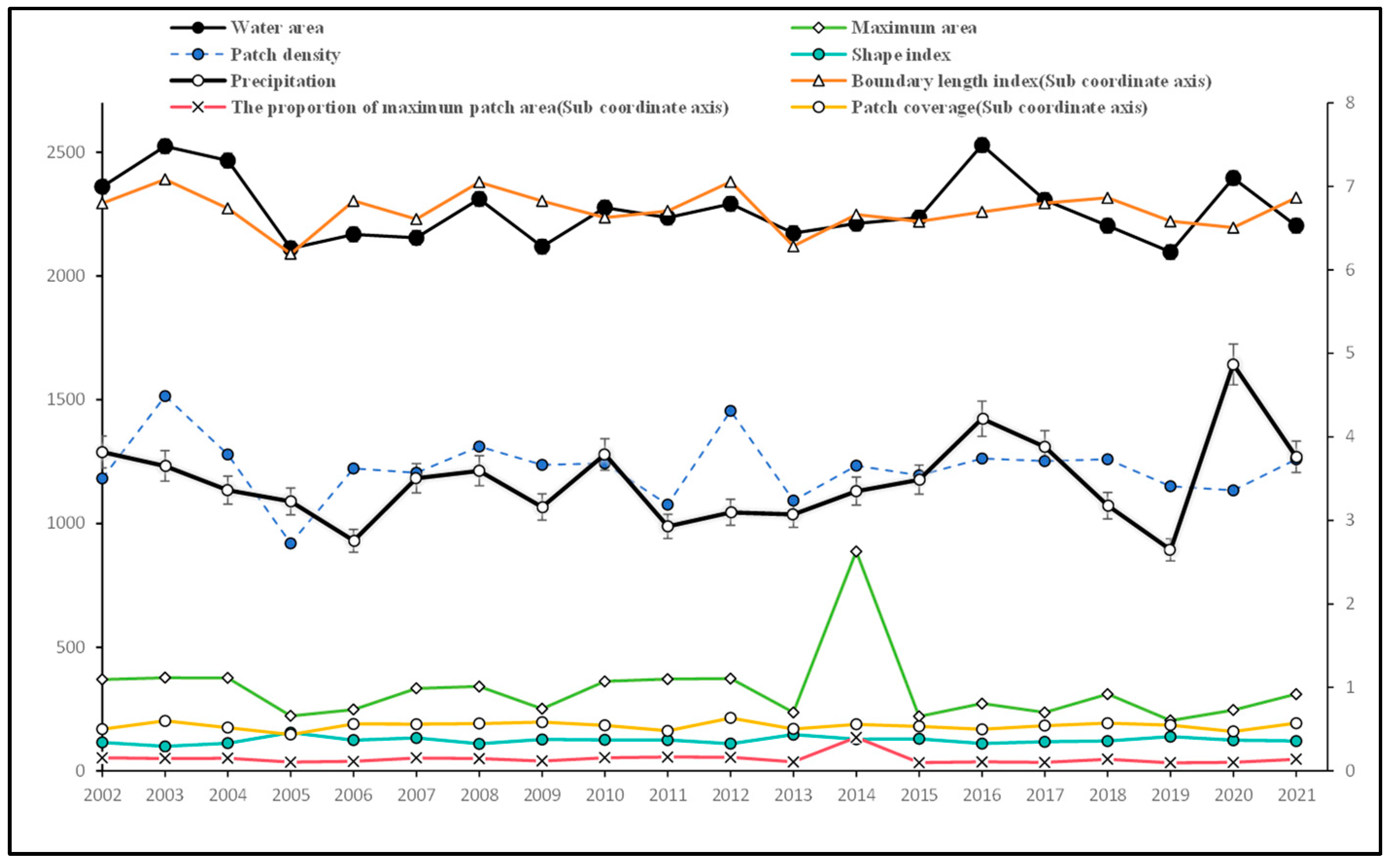
4.1.2. Temporal Characteristics of Water Landscape Indices
4.1.3. Spatial Distribution Characteristics of Water Landscape Index
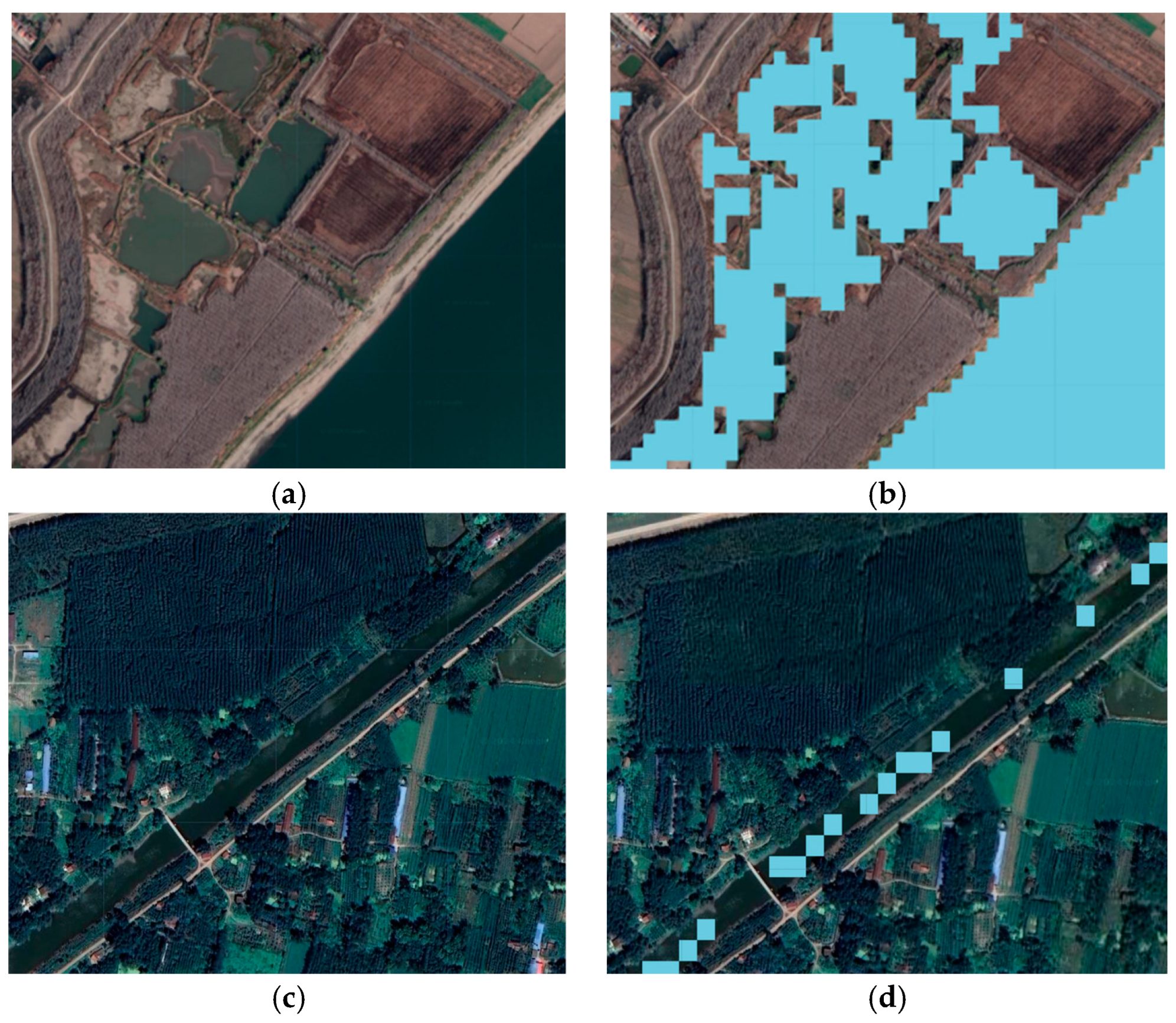
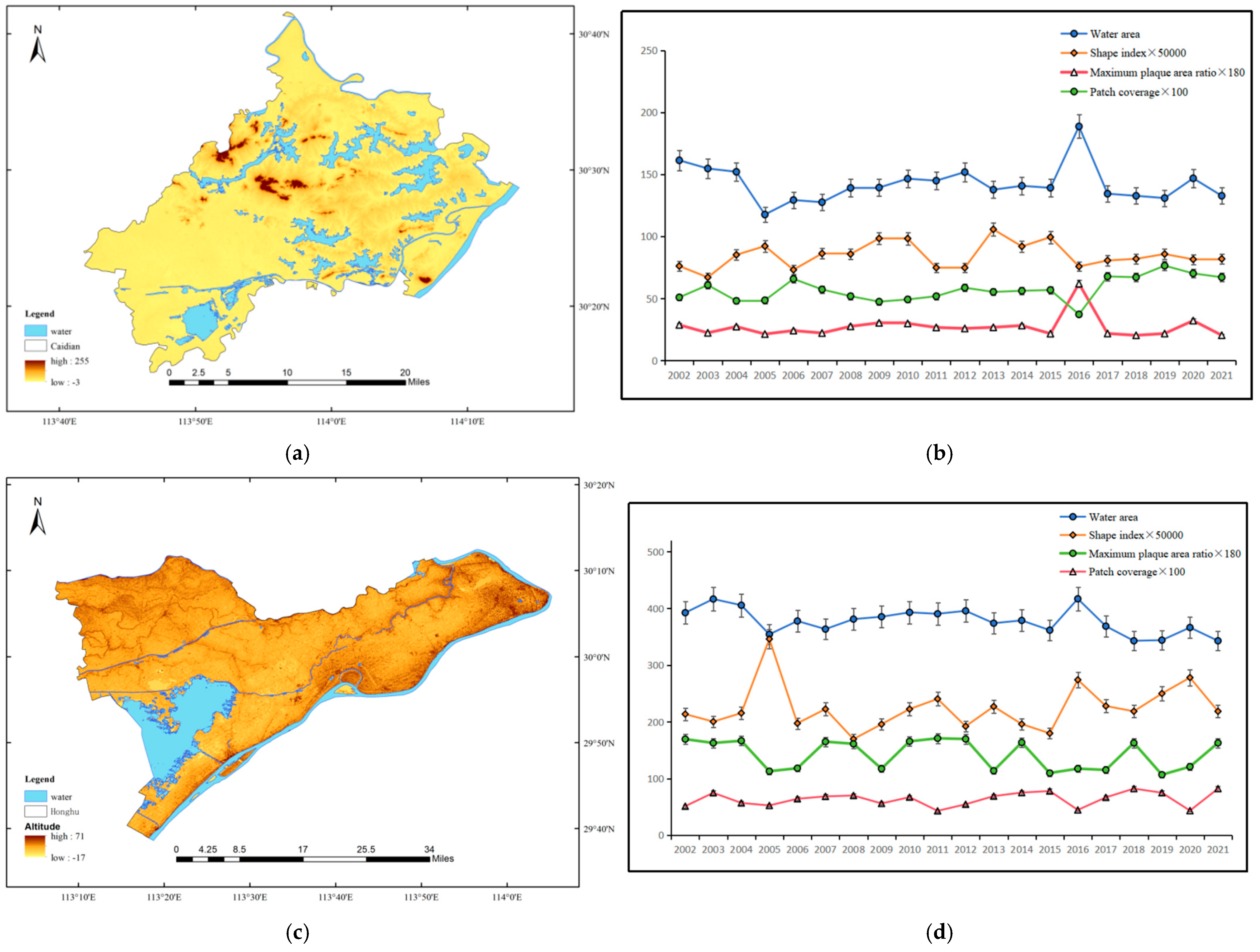
4.1.4. Analysis of Typical Area
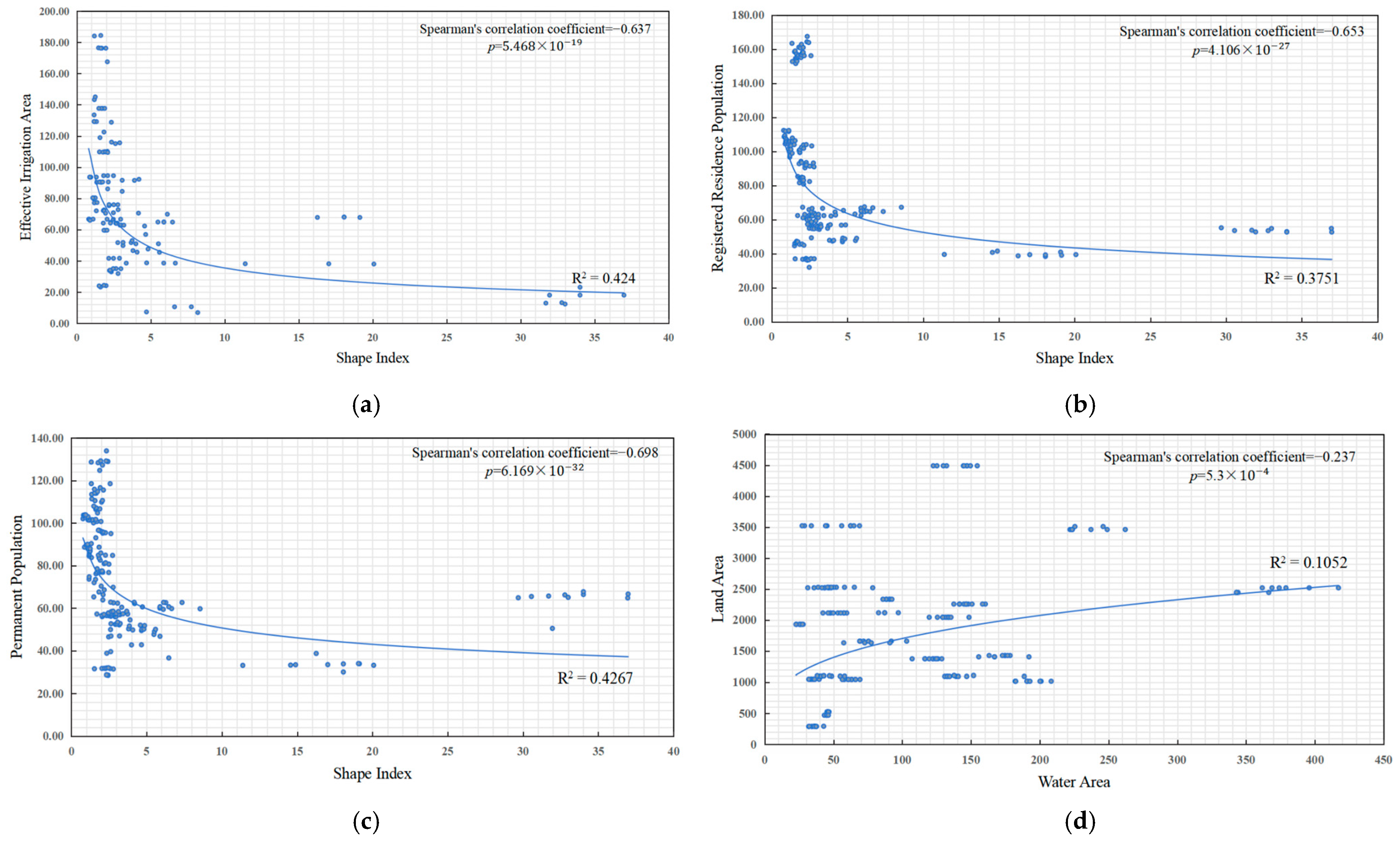
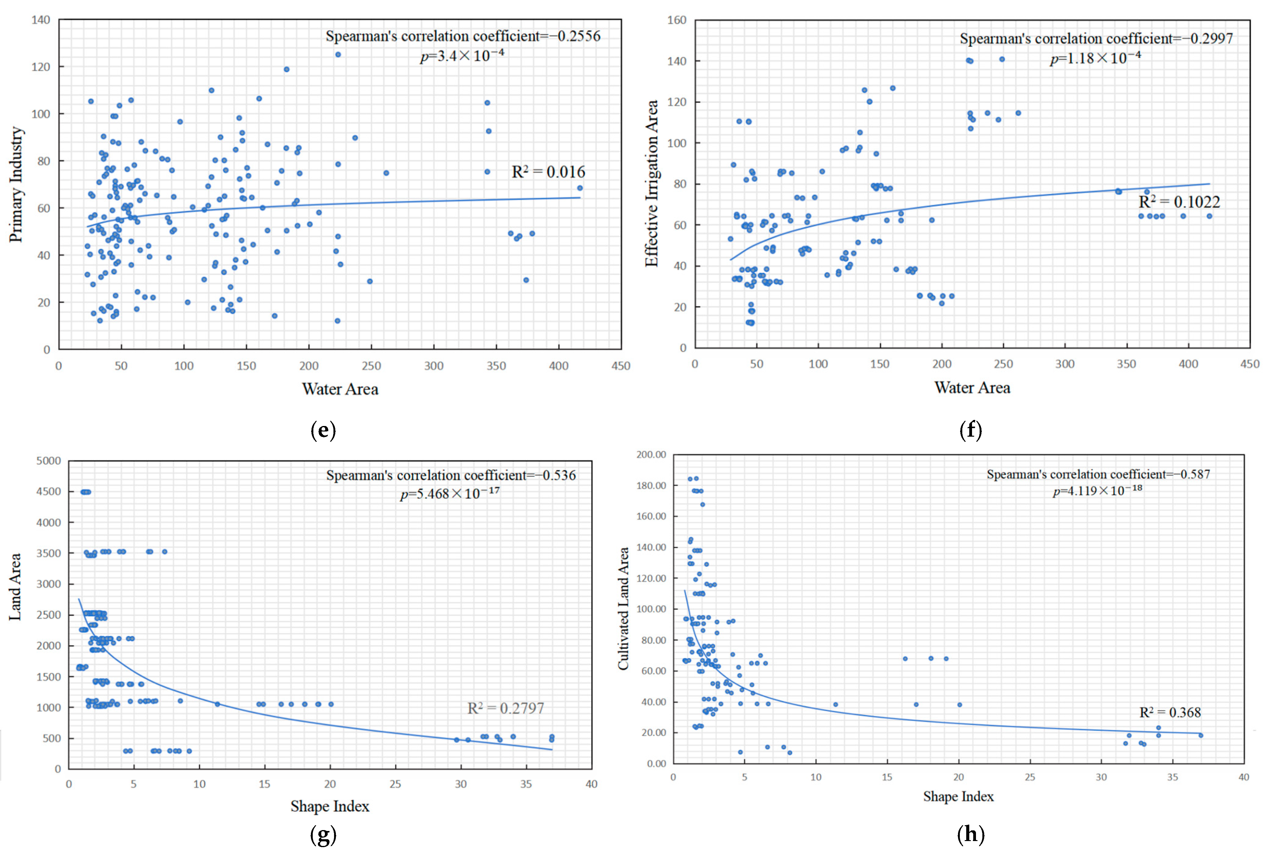
4.2. Correlation Relationships between the Water Landscape Indices and Economic Attributes
4.3. The Associative Characteristics between Water Bodies and Built-Up Areas
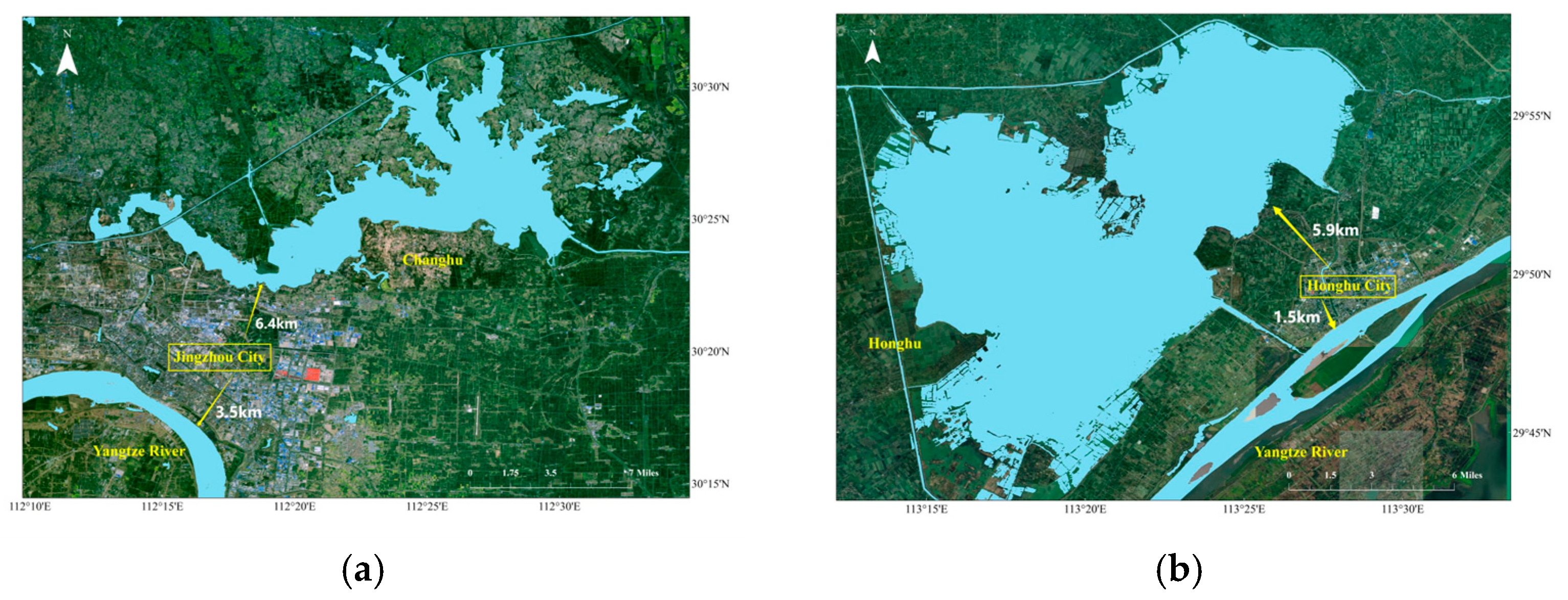
4.3.1. Analysis of Distance between Centers of Built-Up Areas and Water Bodies
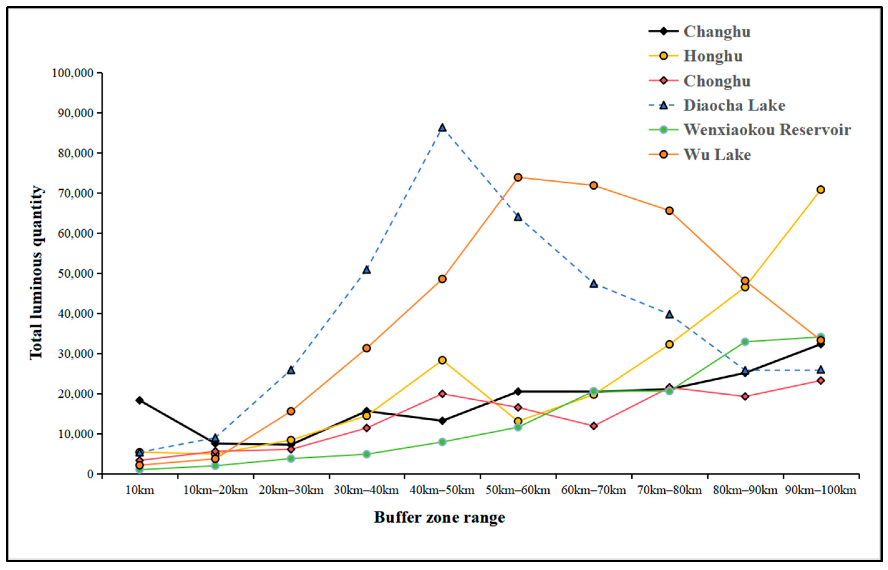
4.3.2. Analysis of Built-Up Areas within the Buffer Zone of Water Bodies
5. Conclusions
- (1)
- The complexity of water bodies is strongly negatively correlated with population and effective irrigation area, indicating that changes in water systems will significantly affect socio-economic activities.
- (2)
- The higher the level and scale of the river, the closer the built-up area is to the river and the larger the area, indicating that the water system affects the planning and construction of the city.
- (3)
- Cities in Jianghan Plain are mostly built along rivers and are mostly distributed on concave banks.
Author Contributions
Funding
Data Availability Statement
Acknowledgments
Conflicts of Interest
Abbreviations
| GEE | Google Earth Engine |
| OA | overall accuracy |
| JRC | Joint Research Centre |
| ER | Ecological resilience |
| SR | surface reflectance |
| DW | Dynamic World |
| NDWI | Normalized Difference Water Index |
| MNDWI | Modified Normalized Difference Water Index |
| MBWI | Multi-Band Water Index |
| AWEI | Automatic Water Extraction Index |
| NDVI | Normalized Difference Vegetation Index |
| EVI | Enhanced Vegetation Index |
| SAR | Synthetic Aperture Radar |
| SDWI | SAR Wetland Detection Index |
| VH | Vertical–Horizontal |
| VV | Vertical–Vertical |
| LSWI | Land Surface Water Index |
References
- He, F.; Lu, P.Y.; Yin, J. Spatial Equilibrium Evaluation and Spatial Correlation Analysis of Water Resources in China. Water Resour. Prot. 2023, 39, 148–155. [Google Scholar]
- Chang, T.; Li, J.; Guo, X. The spatial temporal characteristics and driving force analysis of water area landscape pattern changes on the Jianghan Plain. Adv. Water Sci. 2023, 34, 21–32. [Google Scholar]
- Su, L.F.; Li, Z.X.; Gao, F. A review of research on remote sensing image water extraction. Land Resour. Remote Sens. 2021, 33, 9–19. [Google Scholar]
- Yang, C.J.; Zhou, C.H. Extracting Residential Areas on the TM Imagery. J. Remote Sens. 2000. [Google Scholar] [CrossRef]
- Cui, Q.; Wang, J.; Wang, M. Vector constrained object-oriented high-resolution remote sensing image water extraction. Remote Sens. Inf. 2018, 33, 115–121. [Google Scholar]
- Tang, D.K.; Wang, F.; Wang, H.Q. A single polarization SAR data flood water detection method based on Markov segmentation. J. Electron. Inf. Technol. 2019, 41, 619–625. [Google Scholar]
- Li, X.G. Research on Water Body Recognition Based on Deep Learning; Harbin Normal University: Harbin, China, 2020. [Google Scholar]
- Franke, C.; Schweikart, J. Mental representation of landmarks on maps: Investigating cartographic visualization methods with eye tracking technology. Spat. Cogn. Comput. 2017, 17, 20–38. [Google Scholar] [CrossRef]
- Legleiter, C.J. A geostatistical framework for quantifying the reach-scale spatial structure of river morphology: 1. Variogram models, related metrics, and relation to channel form. Geomorphology 2014, 205, 65–84. [Google Scholar] [CrossRef]
- Nguyen, C.; Daly, E.; Pauwels, V.R.N. A dynamic connectivity metric for complex river wetlands. J. Hydrol. 2021, 603, 127163. [Google Scholar] [CrossRef]
- Horton, R.E. Erosional development of streams and their drainage basins; hydrophysical approach to quantitative morphology. Geol. Soc. Am. Bull. 1945, 56, 275–370. [Google Scholar] [CrossRef]
- Vassoney, E.; Mochet, A.M.; Bozzo, M. Definition of an indicator assessing the impact of a dam on the downstream river landscape. Ecol. Indic. 2021, 129, 107941. [Google Scholar] [CrossRef]
- Fang, G.; Yan, M.; Dai, L. Improved indicators of hydrological alteration for quantifying the dam-induced impacts on flow regimes in small and medium-sized rivers. Sci. Total Environ. 2023, 867, 161499. [Google Scholar] [CrossRef]
- Bosch, M.; Jaligot, R.; Chenal, J. Spatiotemporal patterns of urbanization in three Swiss urban agglomerations: Insights from landscape metrics, growth modes and fractal analysis. Landsc. Ecol. 2020, 35, 879–891. [Google Scholar] [CrossRef]
- Zhu, Z.; Liu, B.; Wang, H. Analysis of the spatiotemporal changes in watershed landscape pattern and its influencing factors in rapidly urbanizing areas using satellite data. Remote Sens. 2021, 13, 1168. [Google Scholar] [CrossRef]
- Zhai, H.; Lv, C.; Liu, W. Understanding spatio-temporal patterns of land use/land cover change under urbanization in Wuhan, China, 2000–2019. Remote Sens. 2021, 13, 3331. [Google Scholar] [CrossRef]
- Fu, F.; Deng, S.; Wu, D. Research on the spatiotemporal evolution of land use landscape pattern in a county area based on CA-Markov model. Sustain. Cities Soc. 2022, 80, 103760. [Google Scholar] [CrossRef]
- Chen, D.; Zhang, F.; Jim, C.Y. Spatio-temporal evolution of landscape patterns in an oasis city. Environ. Sci. Pollut. Res. 2023, 30, 3872–3886. [Google Scholar] [CrossRef]
- Huang, L.; Zhang, W.; Jiang, C.; Fan, X. Ecological footprint method in water resources assessment. Acta Ecol. Sin. 2008, 28, 1279–1286. Available online: http://www.ecologica.cn/stxb/ch/reader/create_pdf.aspx?file_no=1000-0933200803-1279-08&flag=1&journal_id=stxb&year_id=2008 (accessed on 6 May 2024).
- Wang, S.; Li, Z.; Long, Y. Impacts of urbanization on the spatiotemporal evolution of ecological resilience in the Plateau Lake Area in Central Yunnan, China. Ecol. Indic. 2024, 160, 111836. [Google Scholar] [CrossRef]
- Ren, W.; Zhang, X.; Peng, H. Evaluation of temporal and spatial changes in ecological environmental quality on Jianghan Plain from 1990 to 2021. Front. Environ. Sci. 2022, 10, 884440. [Google Scholar] [CrossRef]
- Chen, P.; Chen, X.F.; Li, S.L. Analysis of spatiotemporal variation of water quality in the Jianghan Plain from 2016 to 2021[J/OL]. J. Guangxi Norm. Univ. 2024, 1–8. [Google Scholar] [CrossRef]
- Sing, T.; Li, J.Q.; Guo, X.N. Analysis of spatiotemporal evolution characteristics and driving factors of water spatial pattern in the Jianghan Plain. Prog. Water Sci. 2023, 34, 21–32. [Google Scholar]
- Hou, X.J. Research on the Spatiotemporal Dynamics of Suspended Sediment Concentration in Large Lakes and Reservoirs in the Middle and Lower Reaches of the Yangtze River Based on Remote Sensing and Its Relationship with Wetland Vegetation Cover; Wuhan University: Wuhan, China, 2020. [Google Scholar]
- Gong, R. The first satellite of the Copernicus program in Europe, Sentinel-1A, has been put into orbit. Int. Space 2014, 5, 41–44. [Google Scholar]
- Yin, X.G.; Jiang, W.G.; Ling, Z.Y.; Wang, X.Y.; Deng, Y.W. Evaluation and fusion of global 10 m land cover data in first batch of Chinese wetland cities. J. Remote Sens. 2023, 27, 1334–1347. [Google Scholar]
- Pekel, J.F.; Cottam, A.; Gorelick, N. High-resolution mapping of global surface water and its long-term changes. Nature 2016, 540, 418–422. [Google Scholar] [CrossRef]
- Zhu, M.S. Research on Land Use Change and Ecological Effects in the Lower Yellow River Region Based on GEE; Shandong Jianzhu University: Jinan, China, 2022. [Google Scholar]
- Guo, T.W.; Huang, H.L.; Sun, X.B. Thin cloud detection and removal in multispectral images of Environment 2 satellite. J. Atmos. Environ. Opt. 2023, 18, 383. [Google Scholar]
- Mo, J.Q.; Tang, X.M.; Li, G.Y. Research on Cloud Detection and Related Algorithms of Laser Altimeter Satellite ICESat-2. Prog. Laser Optoelectron. 2020, 57, 240–248. [Google Scholar]
- Wu, L.; Chen, Y.; Zhang, G. Integrating the JRC monthly water history dataset and geostatistical analysis approach to quantify surface hydrological connectivity dynamics in an Ungauged multi-lake system. Water 2021, 13, 497. [Google Scholar] [CrossRef]
- Brown, C.F.; Brumby, S.P.; Guzder-Williams, B. Dynamic World, Near real-time global 10 m land use land cover mapping. Sci. Data 2022, 9, 251. [Google Scholar]
- Claverie, M.; Vermote, E.F.; Franch, B. Evaluation of the Landsat-5 TM and Landsat-7 ETM+ surface reflectance products. Remote Sens. Environ. 2015, 169, 390–403. [Google Scholar] [CrossRef]
- Li, L.; Su, H.; Du, Q. A novel surface water index using local background information for long term and large-scale Landsat images. ISPRS J. Photogramm. Remote Sens. 2021, 172, 59–78. [Google Scholar] [CrossRef]
- Huang, S.; Tang, L.; Hupy, J.P. A commentary review on the use of normalized difference vegetation index (NDVI) in the era of popular remote sensing. J. For. Res. 2021, 32, 1–6. [Google Scholar] [CrossRef]
- Son, N.T.; Chen, C.F.; Chen, C.R. A comparative analysis of multitemporal MODIS EVI and NDVI data for large-scale rice yield estimation. Agric. For. Meteorol. 2014, 197, 52–64. [Google Scholar] [CrossRef]
- Peng, Z.H.; Tan, X. The Application of Parallel Improved Naive Bayesian Algorithm in Chinese Text Classification. Sci. Technol. Innov. 2020, 26, 176–178. [Google Scholar]
- Ning, X.G.; Chang, W.T.; Wang, H. Extraction of information on marshes and wetlands in the Heilongjiang River Basin using a combination of GEE and multi-source remote sensing data. J. Remote Sens. 2022, 26, 386–396. [Google Scholar]
- Liu, Y.; Li, L.H.; Yang, J.M.; Chen, X.; Zhang, R. Snow depth inversion based on D-InSAR method. Remote Sens. 2018, 22, 802–809. [Google Scholar] [CrossRef]
- Zhang, L.P.; Xia, J.; Hu, Z.F. Analysis of China’s Water Resources Status and Water Resources Security Issues. Resour. Environ. Yangtze River Basin 2009, 18, 116–120. [Google Scholar]
- Zhang, J.Y.; Wang, Y.T.; Liu, C.S. Special Article: Discussion on Urban Floods and Prevention Standards in China. J. Hydroelectr. Power 2017, 36, 1–6. [Google Scholar]
- Li, J. Comparative Analysis of the Impact of Water Systems on Urban Spatial Form: A Case Study of Amsterdam and Hangzhou. Green Technol. 2018, 7, 40–43. [Google Scholar]
- Wang, Z.Z.; Jia, W.Y.; Feng, W.Y. Investigation on the Relationship between County level Administrative Center Urban Areas and Rivers in Anhui Province. J. Taiyuan Norm. Univ. Nat. Sci. Ed. 2016, 15, 72–75. [Google Scholar]




| Data | Source | Data Type | Spatial Resolution | Source Link |
|---|---|---|---|---|
| Administrative Divisions in the Jianghan Plain | OpenStreetMap | Vector data | - | hubei|OpenStreetMap (accessed on 1 December 2023) |
| City Economic Attributes Data of Jianghan Plain | Hubei Provincial Bureau of Statistics | Tabular data | - | http://tjj.hubei.gov.cn/tjsj/sjkscx/tjnj/gsztj/whs/ (accessed on 15 December 2023) |
| Landsat series Surface Reflectance Data Set | United States Geological Survey | Raster data | 30 m | Earth Engine Data Catalog|Google for Developers (accessed on 7 January 2024) |
| Sentinel Satellite Image Data Set | European Space Agency | Raster data | 30 m | Earth Engine Data Catalog|Google for Developers (accessed on 6 March 2024) |
| Dynamic World (DW) Near Real-Time Land Use and Land Cover Data Set | Raster data | 10 m | https://developers.google.com/earth-engine/datasets/catalog/GOOGLE_DYNAMICWORLD_V1 (accessed on 1 April 2024) | |
| Joint Research Centre (JRC) Monthly Water History Data Set | JRC of the European Union | Raster data | 30 m | https://developers.google.com/earth-engine/datasets/catalog/JRC_GSW1_4_MonthlyHistory (accessed on 14 March 2024) |
| Water Landscape Indices | English Abbreviation | Formula | Type | Selection Criteria |
|---|---|---|---|---|
| Water area | Area | - | (1) Spatial distribution of water systems | Used to evaluate the water resource status within the watershed, which is beneficial for flood risk assessment and flood simulation model construction |
| Water Length | TE | - | Reflect the distribution and connectivity of water bodies in geographical space, as well as the distribution of different types and forms of water bodies | |
| Quantity | NP | - | Reflecting the distribution and spatial pattern of water bodies, measuring the degree of fragmentation of water bodies | |
| Maximum area | LP | - | (2) Ecological service capacity of water systems | Measuring the ecological function of water bodies, larger water areas provide more habitats and ecological services |
| The proportion of maximum patch area | LPI | LP/Area | Evaluate the relative importance of the largest patch in the entire landscape | |
| Patch coverage | PD | NP/Area | (3) Landscape complexity of water systems | Also known as landscape fragmentation, high patch density reflects the richness and complexity of the geographical region’s landscape, and displays a more complex and fragmented spatial pattern |
| Boundary length index | BLI | TE/Area | The high boundary length index reflects the presence of numerous isolated or dispersed patches in a geographic region | |
| Shape index | LSI | (4π × Area)/(TE2) | The high shape index reflects the regular shape of geographical patches, without obvious bumps or branches |
| Algorithm | OA | Kappa | Class | User Accuracy | Producer’s Accuracy |
|---|---|---|---|---|---|
| Landsat Multi-Index Relationship and Water Probability Thresholding Method-Mean | 0.9723 | 0.938 | Non-Water | 0.988 | 0.935 |
| Water | 0.964 | 0.994 | |||
| JRC Dataset-Mean | 0.9536 | 0.902 | Non-Water | 0.985 | 0.942 |
| Water | 0.937 | 0.996 | |||
| SDWI Index-Mean | 0.9722 | 0.937 | Non-Water | 0.957 | 0.960 |
| Water | 0.980 | 0.969 | |||
| Landsat 8 Forever-Mean | 0.9614 | 0.914 | Non-Water | 0.962 | 0.927 |
| Water | 0.961 | 0.981 |
| River | Distance from the Center of Major Built-Up Areas to the Nearest River in Kilometers | Note |
|---|---|---|
| Yangtze River | 4 km, 10 km, 41 km | Main stream |
| Dongjing River | 30 km, 50–60 km | Han River tributary |
| Neijing River | 22 km, 34 km | Yangtze River tributary |
| Hanbei River | 30 km, 70 km | Han River tributary |
| Han River | 10–20 km, 40–50 km | Yangtze River tributary |
Disclaimer/Publisher’s Note: The statements, opinions and data contained in all publications are solely those of the individual author(s) and contributor(s) and not of MDPI and/or the editor(s). MDPI and/or the editor(s) disclaim responsibility for any injury to people or property resulting from any ideas, methods, instructions or products referred to in the content. |
© 2024 by the authors. Licensee MDPI, Basel, Switzerland. This article is an open access article distributed under the terms and conditions of the Creative Commons Attribution (CC BY) license (https://creativecommons.org/licenses/by/4.0/).
Share and Cite
Dong, F.; Huang, J.; Meng, L.; Li, L.; Zhang, W. Research on Jianghan Plain Water System Dynamics and Influences with Multiple Landsat Satellites. Remote Sens. 2024, 16, 2770. https://doi.org/10.3390/rs16152770
Dong F, Huang J, Meng L, Li L, Zhang W. Research on Jianghan Plain Water System Dynamics and Influences with Multiple Landsat Satellites. Remote Sensing. 2024; 16(15):2770. https://doi.org/10.3390/rs16152770
Chicago/Turabian StyleDong, Feiyan, Jie Huang, Linkui Meng, Linyi Li, and Wen Zhang. 2024. "Research on Jianghan Plain Water System Dynamics and Influences with Multiple Landsat Satellites" Remote Sensing 16, no. 15: 2770. https://doi.org/10.3390/rs16152770
APA StyleDong, F., Huang, J., Meng, L., Li, L., & Zhang, W. (2024). Research on Jianghan Plain Water System Dynamics and Influences with Multiple Landsat Satellites. Remote Sensing, 16(15), 2770. https://doi.org/10.3390/rs16152770


