Article

Long-Term Evaluation of Aerosol Optical Properties in the Levantine Region: A Comparative Analysis of AERONET and Aqua/MODIS

by
Ayse Gokcen Isik
1,2,
S. Yeşer Aslanoğlu
1,* and
Gülen Güllü
1
1
Department of Environmental Engineering, Hacettepe University, Beytepe, Ankara 06800, Turkey
2
Graduate School of Science and Engineering, Hacettepe University, Beytepe, Ankara 06800, Turkey
*
Author to whom correspondence should be addressed.
Remote Sens. 2024, 16(14), 2651; https://doi.org/10.3390/rs16142651
Submission received: 5 June 2024 / Revised: 7 July 2024 / Accepted: 18 July 2024 / Published: 20 July 2024

Abstract

:
The focus on aerosol analysis in the Levantine Region is driven by climate-change impacts, the region’s increasing urban development and industrial activities, and its geographical proximity to major dust-source areas. This study conducts a comparative analysis of aerosol optical depth data from Aqua/MODIS and AERONET during different periods between 2003 and 2023 at four stations: IMS-METU-ERDEMLI (Mersin/Türkiye) (2004–2019), CUT-TEPAK (Limassol/Cyprus) (2010–2023), Cairo_EMA_2 (Cairo/Egypt) (2010–2023), and SEDE_BOKER (Sede Boker/Israel) (2003–2023). The objective is to evaluate the variability and reliability of AOD measurements between satellite and ground-based observations and to determine how well they represent regional climatology. The highest percentage of measurements within the expected error envelope was observed at the IMS-METU-ERDEMLI station, indicating the best agreement between MODIS and AERONET data at this location. The Seasonal-Trend Decomposition using Loess (STL) method revealed consistent spring and summer peaks influenced by dust transport from the Sahara and the Middle East, with lower values in winter. The study also considers the influence of cloud fraction on MODIS measurements and includes aerosol classification. A statistically significant slight positive trend in AOD values was identified at the IMS-METU-ERDEMLI station. Conversely, no significant trends were detected at the other stations. The results of this study agree with those of previous research on the impact of long-range dust transport on regional aerosol loadings, emphasizing the importance of integrating satellite and ground-based observations.

1. Introduction

Atmospheric aerosols originating from both natural and anthropogenic sources play a crucial role in various natural processes, affecting climate, ecosystems, and air quality on a global scale. These particles have the potential to profoundly influence our entire planet by both directly and indirectly interacting with the Earth’s radiation budget. Aerosols directly modify the planetary radiation budget by scattering and absorption of long- and shortwave radiation. Depending on their size and chemical composition, aerosols can act as cloud-condensation nuclei (CCN) and ice nuclei (IN) and impact cloud microphysical processes, which indirectly influence the global energy budget. The aerosol−cloud−radiation interaction also modifies precipitation processes, the hydrological cycle, and climate [1].
Aerosols originate from various sources and have significant impacts on climate, health, and the environment, thereby impacting human well-being. The inhalation of aerosols, particularly fine particulate matter (PM2.5), can lead to various adverse health effects, including respiratory and cardiovascular diseases, cancer, and premature death [2]. Consequently, it is essential to thoroughly investigate the physical properties of aerosols. Satellite-based remote sensing, alongside ground-based observations, plays a pivotal role in monitoring aerosol optical properties, improving our understanding of atmospheric processes. This comprehensive monitoring provides critical information on environmental pollution and helps in the analysis of the effects of aerosols and clouds on radiative fluxes [3].
Both spaceborne and ground-based observations offer a comprehensive assessment of long-term spatial, temporal, and seasonal variations in aerosol optical properties. For the investigation of atmospheric aerosol properties, satellite data have advantages and disadvantages compared to ground-based observations. Satellite data provide a global perspective with extensive coverage of aerosol distributions, while ground-based platforms have relatively small spatial coverage but deliver high temporal resolution. In contrast, space-borne observations have limited temporal resolution [4]. The necessity of verifying satellite data is underscored by the need to ensure accuracy and reliability in global aerosol observations for air-quality, environmental, and climate research. Global satellite observations of aerosol properties are invaluable for validating and refining model simulations across extensive spatial and temporal scales [5,6]. However, satellite data alone can have gaps and uncertainties. Integrating satellite observations with ground-based measurements helps to provide a more consistent and accurate picture of global aerosol distributions, ensuring that the satellite-derived data align well with the ground-based observations [5,6]. This verification process is crucial for constraining and validating the aerosol properties observed from space, ultimately leading to better climate models and environmental assessments.
The significance of studies on air quality and mineral dust in the Levantine Region is highlighted by the influence of urbanization, increased industrial activities, climate change, and the region’s geographical proximity to deserts. The Eastern Mediterranean basin, including the Levantine Region, falls within the dust belt and is subjected to the presence of dust particles originating from two of the largest dust-source regions, namely the Sahara (North Africa) and the Middle East (the Arabian Peninsula and Syria), as reported by various studies [7,8]. Numerous investigations have focused on the air quality and dust composition in the region, highlighting the need for ongoing research and interventions to address the environmental and health impacts of aerosols. Those aerosol-monitoring studies have utilized space-borne observational platforms such as Advanced Very High Resolution Radiometer (AVHRR), Meteosat Visible and Infra-Red Imager (MVIRI) [9], Total Ozone Mapping Spectrometer (TOMS) [7,10,11], Moderate Resolution Imaging Spectroradiometer (MODIS) [11,12], and Cloud–Aerosol Lidar with Orthogonal Polarization (CALIOP) [13].
The aerosol optical depth (AOD) data from MODIS have undergone comprehensive analysis and validation, as discussed in various studies [14,15]. These investigations focused on ensuring the accuracy and reliability of MODIS AOD data, particularly through comparisons with ground-based Aerosol Robotic Network (AERONET) measurements [7,16,17]. The validated MODIS AOD data have found extensive use in aerosol research, highlighting their significance in contributing to scientific studies in this field.
While previous studies have often focused on shorter time frames or isolated periods over the Eastern Mediterranean, this study provides an extensive temporal analysis covering nearly two decades (2003–2023), offering a comprehensive view of aerosol trends and variations over time using the Seasonal−Trend decomposition using Loess (STL) method. This method allows for a detailed separation of seasonal patterns, trends, and irregular components. Although all the selected stations are located in the Levantine region, our detailed analysis will highlight the regional differences, providing a nuanced understanding of aerosol behaviors across different environments. Cloud-fraction analysis is incorporated to account for the impact of cloud cover on aerosol measurements, addressing potential biases and uncertainties in the data.
In this study, regridded MODIS Level 2 data were generated and compared with AERONET Version 3 Level 2 data to evaluate the performance of Aqua-MODIS AOD at 10 km spatial resolution. The analysis focused on the IMS-METU-ERDEMLI, CUT-TEPAK, Cairo_EMA_2, and SEDE_BOKER stations. This paper is organized as follows: Section 2 briefly introduces satellite products (Aqua/MODIS) and ground-based AERONET data and clarifies the validation approach. Section 3 presents detailed validation results, aerosol classification, time-series analysis, and discussion. Conclusions are presented in Section 4.

2. Materials and Methods

2.1. MODIS

The Terra and Aqua satellites are polar-orbiting, sun-synchronous satellites that were launched in late 1999 and early 2002, respectively, and that carry the Moderate Resolution Imaging Spectroradiometer (MODIS) onboard [14]. The Terra satellite follows a trajectory from north to south across the equator in the morning, while Aqua’s orbit follows a trajectory from south to north over the equator in the afternoon. Both satellites offer comprehensive observation by covering the entire Earth’s surface every one to two days. MODIS includes 36 spectral channels from 0.41 to 15 μm with a nominal resolution of 250 m, 500 m, or 1 km at nadir, depending on the measurement band, and has a swath width of approximately 2300 km [15].
Current practices for MODIS involve the use of separate algorithms tailored for dark and bright surfaces [18]. Three operational retrieval algorithms, Dark Target (DT) [19], Deep Blue (DB) [20], and Multiangle Implementation of Atmospheric Correction (MAIAC) [21], are currently utilized for aerosol retrievals. These algorithms were developed at NASA’s Goddard Space Flight Center by the MODIS team. The recently developed MAIAC product and the widely used DT & DB combined AOD product are both extensively utilized [19,22]. Numerous studies have focused on the integration of Level 2 (L2) datasets in different atmospheric studies [19,22].
The objective of earlier validation studies was to define the expected error (EE) envelope at 550 nm over ocean and land. This EE envelope includes at least 67% (roughly one standard deviation) of the data points on a scatterplot [23]. For land, the EE envelope is defined as ±(0.05 + 0.15 AOD) [19,23]. For ocean, the EE envelope of ±(0.03 + 0.05 AOD) is defined for Collection 5 dataset [23]. However, for Collection 6 (C6), the EE limits for ocean have been refined asymmetrically, +(0.04 + 0.1 AOD), and −(0.02 + 0.1 AOD) [19].
MODIS datasets are organized into various collections based on the version of the retrieval algorithms and into different levels according to their spatial and temporal resolution. Level 2 (L2) retrievals, reported in 5-min swath granules [15], are accessible from the Atmosphere Archive and Distribution System (LAADS) Distributed Active Archive Center (DAAC) (https://ladsweb.modaps.eosdis.nasa.gov/, accessed on 6 January 2024). In Collection 6 (C6), MODIS retrievals provide a Quality Assurance (QA)-filtered merged dataset that combines DT and DB retrievals. This merging process is implemented to enhance the spatial coverage of the retrievals [22]. Moreover, MODIS uses quality flags to represent the accuracy of AOD retrievals, which range from 3 (high confidence) to 0 (low or no confidence) [15]. The quality flags are assigned to each MODIS AOD retrieval based on the number and quality of pixels used in the AOD algorithms [14,15]. Previous studies have shown that the quality flags associated with MODIS retrievals play a significant role in MODIS AOD error approximation [14,15].
For our research, Collection 6.1 (C061) MODIS-Aqua Level 2 (L2) retrievals covering the Levantine Region and spanning the period from 2003 to 2023 are utilized. In order to evaluate MODIS AOD against AERONET AOD for this study, the C6.1 DT & DB combined dataset, including AOD and cloud fraction (CF), was regridded to 0.1°. The “AOD_550_Dark_Target_Deep_Blue_Combined” variable, referred to as AOD in our study, was filtered based on quality flags. Since each file of the MODIS Level 2 dataset includes a granule scan, each scan of MODIS data was interpolated to specific latitude and longitude index values. Accordingly, time-series data of 0.2° × 0.2° areas, which corresponds to approximately 30 min of overpass, covering each station point were subset. This method provides an accurate comparison by aligning spatially and temporally proximate data from both observation sets. AERONET-station datasets for AE and AOD were utilized to further evaluate aerosol types, while MODIS CF data were used to generate various AOD datasets for comparison with concurrent AERONET AOD measurements.

2.2. AERONET

AERONET is a global network of ground-based stations distributed worldwide, delivering quality-controlled data on aerosol optical properties [3,24]. The primary parameter measured is the column-integrated Aerosol Optical Thickness (AOT) obtained through automatic CIMEL Sun–Sky scanning photometers [3]. AERONET instruments precisely measure spectral AOT at wavelengths of 0.38, 0.44, 0.50, 0.67, 0.87, and 1.02 μm [25]. AERONET aerosol-product quality levels are categorized into three categories: Level 1.0 (raw data without cloud screening), Level 1.5 (cloud-screened), and Level 2.0 (cloud-screened and also quality-assured) [26]. Although AERONET refers to these data as Aerosol Optical Thickness (AOT), they will be hereinafter referred to as Aerosol Optical Depth (AOD) throughout this study.
In the AERONET database Version 2 (V2), the near-real-time AOD underwent a semi-automated quality-control process that primarily uses cloud-screening methodology and eliminates instrument anomalies to attain the Level 2.0 dataset. The substantial increase in the number of AERONET stations over more than 25 years posed a considerable challenge to consistent performance of manual quality control of millions of measurements. The AERONET Version 3 (V3) algorithm offers completely automated cloud screening and quality controls for instrument anomalies [25].
Depending on the exact type of instrument used, a variety of wavelengths are collected, ranging from 0.34–1.6 μm. In this study, in order to fall within a wavelength window consistent with that of the MODIS observations, AERONET AOD is interpolated to 550 nm using the AOD at 500 nm and Angstrom exponent of 440–870 nm with Equation (1) [3,25,27], as follows:
A O D 550 = A O D 500 550 500 A E 440 870
To validate the accuracy of satellite aerosol products, AERONET level 2 version 3 (L2/V3) AOD, which has been cloud-screened and quality-assured, was obtained from the official AERONET website (https://aeronet.gsfc.nasa.gov/, accessed on 16 February 2024). Data were collected for four AERONET stations: IMS-METU-ERDEMLI in Mersin / Türki-ye, CUT-TEPAK in Limassol/Cyprus, Cairo_EMA_2 in Cairo/Egypt, and SEDE_BOKER in Sede Boker/Israel (Figure 1). Table 1 provides detailed information about these four AERONET stations used in the research across the Levantine Region.

2.3. Study Domain

The Levantine region, encompassing parts of the Eastern Mediterranean, is a geographically and culturally diverse area. The region provides a unique environment for aerosol research, including varied compositions and concentrations influenced by local emissions, atmospheric-transport patterns, and land-use practices. Bordered by deserts, marine habitats, and urban areas, the region faces threats related to global warming and climate change [13]. It spans across parts of Türkiye, Lebanon, Syria, Jordan, Israel, Palestine, Egypt, and Cyprus.

2.3.1. Erdemli/Mersin (IMS-METU-ERDEMLI)

Türkiye hosts only one operational AERONET station, which is located at the Institute of Marine Sciences—Middle East Technical University (IMS-METU) in Erdemli and has been providing data since 1999. The site is primarily affected by three types of aerosols: (1) mineral dust originating from the Sahara and the Middle Eastern deserts, (2) sea salt from the Mediterranean Sea, and (3) anthropogenic particles from industrialized and semi-industrialized areas [10].

2.3.2. Limassol/Cyprus (CUT-TEPAK)

Aerosol particles in Cyprus display considerable variation in their source and composition. Both natural and anthropogenic aerosols arising from local sources, exhibit spatial and temporal changes in composition. Cyprus frequently experiences the transport of desert dust that originates from North Africa or the Middle East. Additionally, biomass-burning aerosols may be transported over long distances from Türkiye and Syria. The station has been operating at Cyprus University of Technology (CUT-TEPAK) in Limassol since 2010, as part of the AERONET network [28].

2.3.3. Cairo/Egypt (Cairo_EMA_2)

Cairo is a megacity known for its elevated pollution levels, which are attributed to heavy traffic, agricultural practices, and other local emissions due to the presence of key commercial and industrial hubs. Therefore, its aerosol composition is complicated, shaped by long-distance dust transport in spring, biomass burning in autumn, and the substantial influence of traffic and industrial emissions [29]. Cairo station is situated in the middle of a large residential region with significant local emissions.

2.3.4. Sede Boker/Israel (SEDE_BOKER)

Sede Boker is situated in the northern sector of the Negev desert, distant from densely populated and industrialized zones. This region of the Negev has a dry climate, with aridity defining its landscape [30]. The station is about 80 km inland from the Mediterranean Sea coast and sits at an elevation of 480 m above sea level. The primary aerosol types influencing the site include locally generated mineral dust, long-range-transported mineral dust, and marine particles [31]. During the summer, air masses typically originate from the northwest, carrying anthropogenic aerosols from densely populated regions of central Israel and from Eastern Europe [32].
Additionally, the coastal regions of Türkiye, Cyprus, and Israel are affected by sea−land breeze circulations, which can intensify aerosol emissions originating from both marine environments and urban activities [33]. The dynamic interaction between the sources and the local atmospheric conditions contributes significantly to the regional air quality and needs to be closely monitored and studied.

2.4. Aerosol Classification

Approaches for classifying aerosol types using AOD and AE have been developed by various researchers [16,34,35]. The aerosol-classification method, as outlined by Dubovik et al. [16], was developed based on the climatology of AOD and AE data of AERONET stations where the dominant type of aerosol is clearly identified. Threshold values were defined to classify aerosol mixtures into six categories: marine, continental, biomass-burning, desert dust, pollution-associated, and mixed-type.
The limitation of this approach lies in the fact that threshold values can vary when dealing with complex aerosol mixtures. In urban environments, it is uncommon to find a mixture wherein only one type of aerosol is present. Consequently, the classification should be seen as identifying the predominant type of particles, those with optical properties that most closely align with the measured data [28].

2.5. Trend Decomposition Analysis

The trend analysis of the station data was carried out using the Seasonal−Trend Decomposition using Loess (STL) method [36]. This robust method decomposes time series data into seasonal, trend, and residual components through embedded Loess (locally weighted regression and scatterplot smoothing) regression-curve smoothing with ordinary least squares polynomial fit. STL is primarily divided into two main procedures: an inner loop and an outer loop. The inner loop, nested in the outer loop, involves six main steps: (1) de-trending, (2) smoothing cycle sub-series, (3) filtering of smoothed cycle sub-series, (4) de-trending cycle sub-series, (5) de-seasonalizing, and (6) trend smoothing. Through these steps, the primary time-series data (Yt) are decomposed into the seasonal cycle (St), trend cycle (Tt), and residuals (Rt), as shown in Equation (2) below:
Y t = S t + T t + R t
For this analysis, monthly mean values from MODIS data were utilized for each station.

3. Results and Discussion

3.1. Comparison of AERONET and MODIS Aerosol Measurements

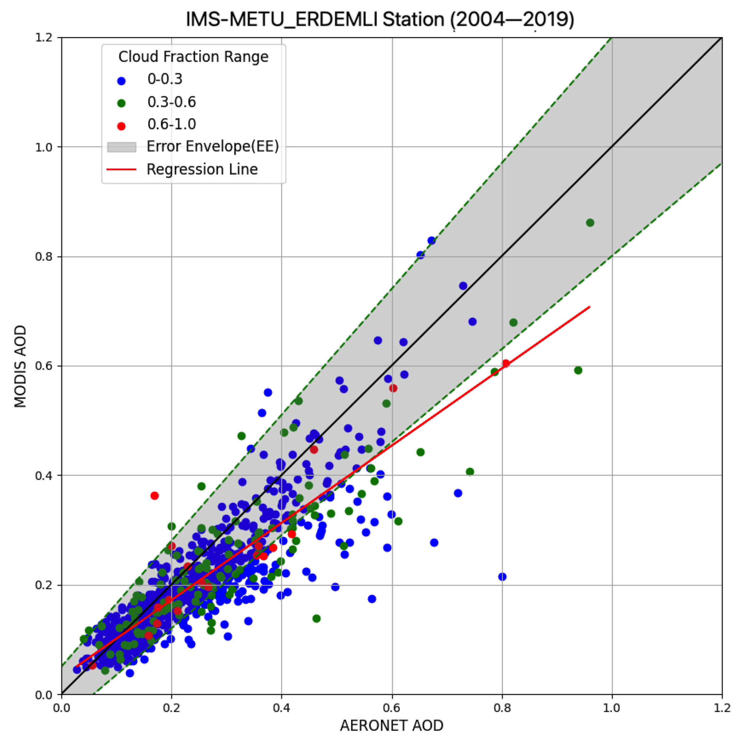
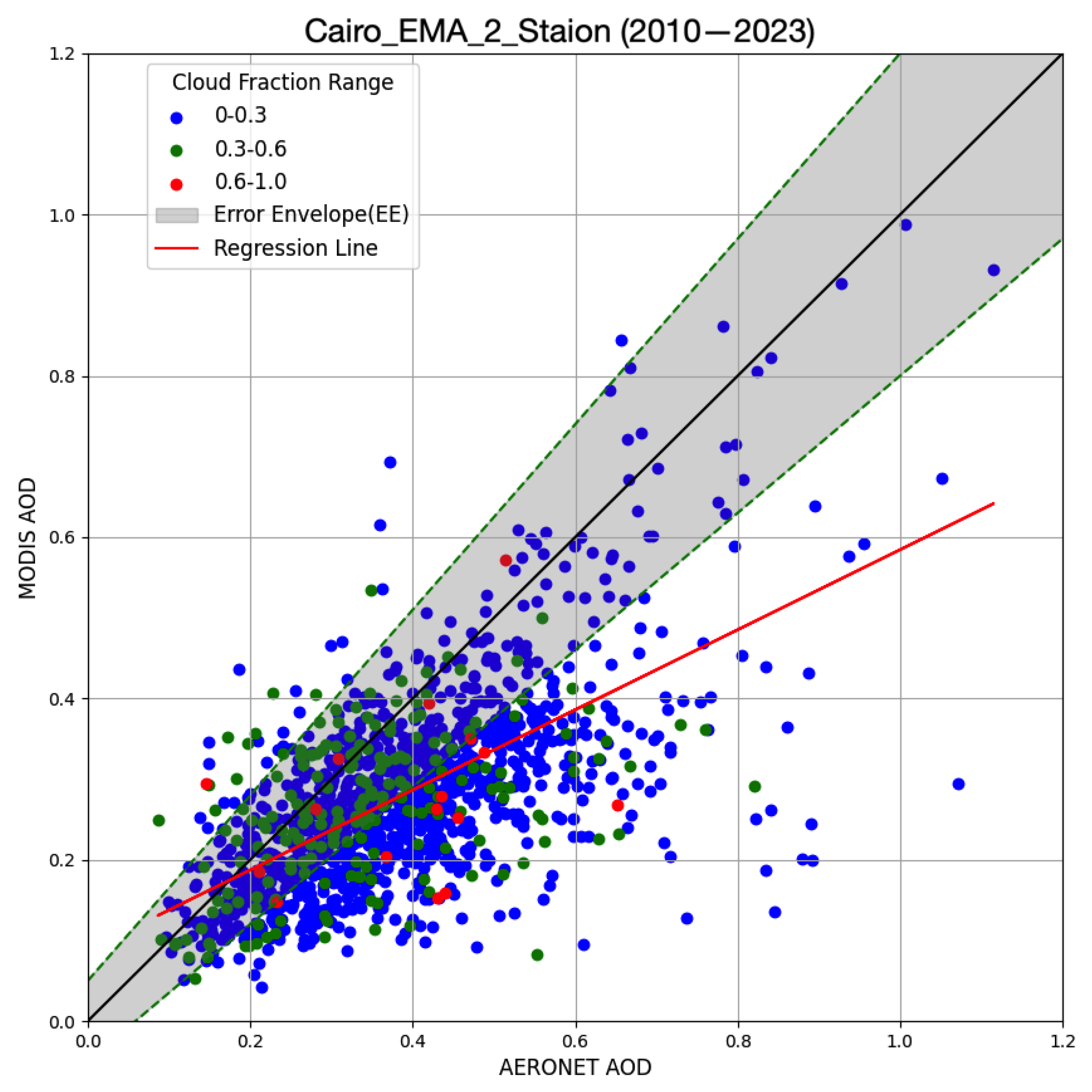
MODIS-Aqua AOD was compared to the averaged AERONET measurements at four stations. The error envelope (EE), which is ±(0.05 + 0.15 AOD) for MODIS, is plotted as a green dashed line in Figure 2, Figure 3, Figure 4 and Figure 5.
Some passive satellite-based aerosol datasets such as MODIS (Collection 5.1) represent increased AOD values over the mid-to-high-latitude regions of the Southern Oceans. Previous research conducted by Toth et al. [37] has identified multiple potential factors contributing to this phenomenon, such as signal uncertainty, retrieval bias, and cloud contamination. Cloud contamination could cause difficulty in distinguishing aerosols from clouds in satellite observations, which may lead to overestimations of AOD. To investigate the impact of cloud contamination on the correlation between MODIS and AERONET AOD measurements, the colors of the points in the graphs represent the cloud-fraction range associated with MODIS measurements. These are categorized as follows: blue for a cloud-fraction range of 0–0.3, green for 0.3–0.6, and red for 0.6–1.0 (Figure 2, Figure 3, Figure 4 and Figure 5). Figure A1 displays the series of MODIS AOD vs. AERONET AOD across four different stations for varying cloud-fraction intervals (CF). Each station was analyzed for three cloud-fraction intervals: CF (0–0.3), CF (0.3–0.6), and CF (0.6–1.0).
For the analysis, MODIS data were defined as the average of all MODIS measurements within a 0.1° distance of an AERONET location. Similarly, AERONET data were calculated as the average of all AERONET measurements within a 30-min window centered around the Aqua/MODIS overpass time. Table 2 summarizes the statistics, including the percentage within the EE, above the EE, and below the EE for all stations, while Table 3 compares the mean and standard deviation of AOD values from MODIS and AERONET, as well as the mean monthly observations for each station.
The statistical analysis for the IMS-METU-ERDEMLI station demonstrates a strong correlation between MODIS and AERONET AOD measurements, with a correlation coefficient (R) of 0.8627 and a coefficient of determination (R2) of 0.7442 (Table 2). Similarly, the CUT-TEPAK station shows a strong correlation, with an R of 0.8658 and an R2 of 0.7496. The regression equation of IMS-METU-ERDEMLI suggests that MODIS tends to slightly underestimate AERONET AOD values, while MODIS data exhibit both overestimation and underestimation tendencies (Figure 2).
Moreover, 82.62% of the measurements fall within the error envelope (EE), indicating a high level of agreement between the two datasets. However, 1.35% of the measurements are above the EE and 16.03% are below it, indicating some degree of variability and the potential for inconsistencies in certain conditions. In clearer-sky conditions (low cloud fraction, 0–0.3, represented by blue), MODIS measurements tend to align more closely with those of AERONET, showing a tighter clustering along the y = x line (Figure A1a in Appendix A).
For CUT-TEPAK station, the majority of data points (70.52%) fall within the error envelope, though there is a notable proportion showing overestimation by MODIS (Figure 3). The scatter of points also shows the influence of cloud fraction, with higher cloud fractions (green and red points as seen in Figure A1e,f in Appendix A) exhibiting more variability and divergence from the y = x line.
The scatterplot in Figure 4 shows the relationship between MODIS and AERONET AOD measurements at the Cairo_EMA_2 station. Data points below the y = x line suggest that MODIS tends to underestimate AERONET values overall. Compared to all the other stations, the RMSE of 0.1585 indicates a relatively higher error magnitude between the MODIS AOD values and the AERONET values. Furthermore, 51.66% of the measurements fall within the error envelope, suggesting moderate agreement between the datasets. At a low cloud-fraction range of 0–0.3, the blue points are closely clustered along the y = x line, suggesting that MODIS AOD measurements are more reliable under low-cloud-fraction conditions (Figure A1g in Appendix A). As the cloud fraction increases to moderate levels (0.3–0.6) (Figure A1h in Appendix A), the points show a slight spread, and at high cloud fractions (0.6–1.0) (Figure A1i in Appendix A), the points become more dispersed.
The Sede_Boker station has a greater number of observations (3773) and covers a longer period (2003–2023) compared to other stations. This extensive dataset provides a comprehensive view of the long-term trends and variations in AOD measurements, offering valuable insights into the long-term performance and reliability of MODIS. The statistical analysis for the Sede_Boker station reveals a weak correlation between MODIS and AERONET AOD measurements. Only 40.23% of the measurements fall within the error envelope, suggesting a lower level of agreement between the datasets (Table 2). A significant 56.00% of the measurements are above the error envelope.
The points with low cloud-fraction range of 0–0.3 (blue) are relatively well-aligned along the y = x line, suggesting that MODIS AOD measurements are more reliable under low cloud fractions (Figure 5 and Figure A1j in Appendix A). The analysis of the green points in the scatterplot for the Sede_Boker station indicates that moderate cloud fractions (0.3–0.6) lead to increased variability and potential inaccuracies in MODIS AOD measurements (Figure A1k in Appendix A). This is demonstrated by the broader dispersion of the green points and their proximity to the boundaries of the error envelope. The red points (high cloud fraction) show even more dispersion than the green points, illustrating that higher cloud cover leads to greater discrepancies in MODIS AOD measurements (Figure A1l in Appendix A).
The correlation coefficients (R) between daily level-2 MODIS C6.1 and AERONET data, influenced by surface type and the retrieval algorithms used, range from 0.65 to 0.97 for Dark Target (DT) and from 0.60 to 0.97 for Deep Blue (DB) algorithms [38]. In their study, Gavrouzou et al. [39] ensured accuracy by excluding retrievals with low R values, selecting the appropriate algorithm for each region. Specifically, DB is applied in arid, semi-arid, and urban areas, while DT is utilized over oceanic regions [39]. This approach highlights an important consideration for maximizing accuracy in aerosol retrievals. In this study, a combined algorithm provided strong correlation values for the IMS-METU-ERDEMLI, CUT-TEPAK, and Cairo_EMA_2 stations, but not for the SEDE_BOKER station. The combined algorithm appears to be effective in diverse environments but may require further refinement for accurate aerosol retrievals in desert regions like SEDE_BOKER.
Across all stations, high cloud-fraction values generally lead to MODIS AOD measurements underestimating AERONET AOD measurements, with the exception of SEDE_BOKER, where greater variability is observed (Figure A1l in Appendix A). The differences were quantified by computing statistics for low-cloud-cover cases (0–0.3) and comparing these results to the statistics for the full dataset (including all cloud cover conditions) presented in Table 2. Through this comprehensive analysis, a deeper understanding of the impact of cloud cover on the agreement between MODIS and AERONET measurements across different stations has been achieved, highlighting the significant discrepancies at the SEDE_BOKER station.

Comparison of MODIS and AERONET AOD across Multiple Stations

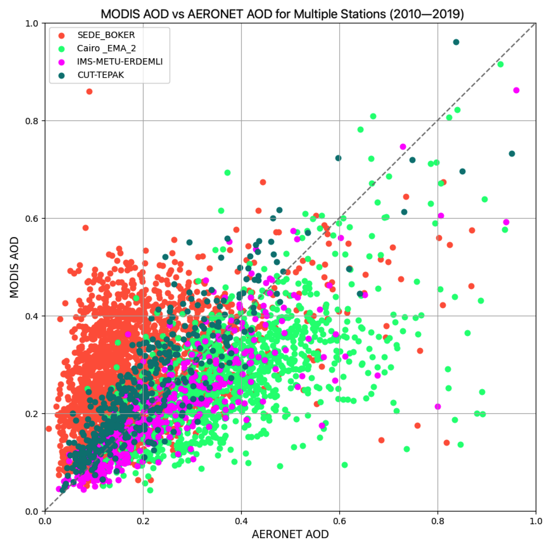
To compare MODIS and AERONET AOD data, the years 2010 to 2019 were selected, as all measurements in the study area were concurrent with satellite observations during this period (see Figure 6). Upon examination of all stations, unique scatter patterns can be observed in the graph, each indicating distinct characteristics. Most data points are concentrated between AOD values of 0.0 and 0.4, indicating the most common range for AOD measurements across these sites. There are fewer observations with values greater than 0.6. Specifically, at the SEDE_BOKER station, MODIS AOD tends to overestimate AERONET AOD values, whereas at the Cairo station, MODIS AOD values are lower than those observed by AERONET. On the other hand, at the Cyprus station (CUT-TEPAK), MODIS AOD values demonstrate good agreement with ground-based observations.
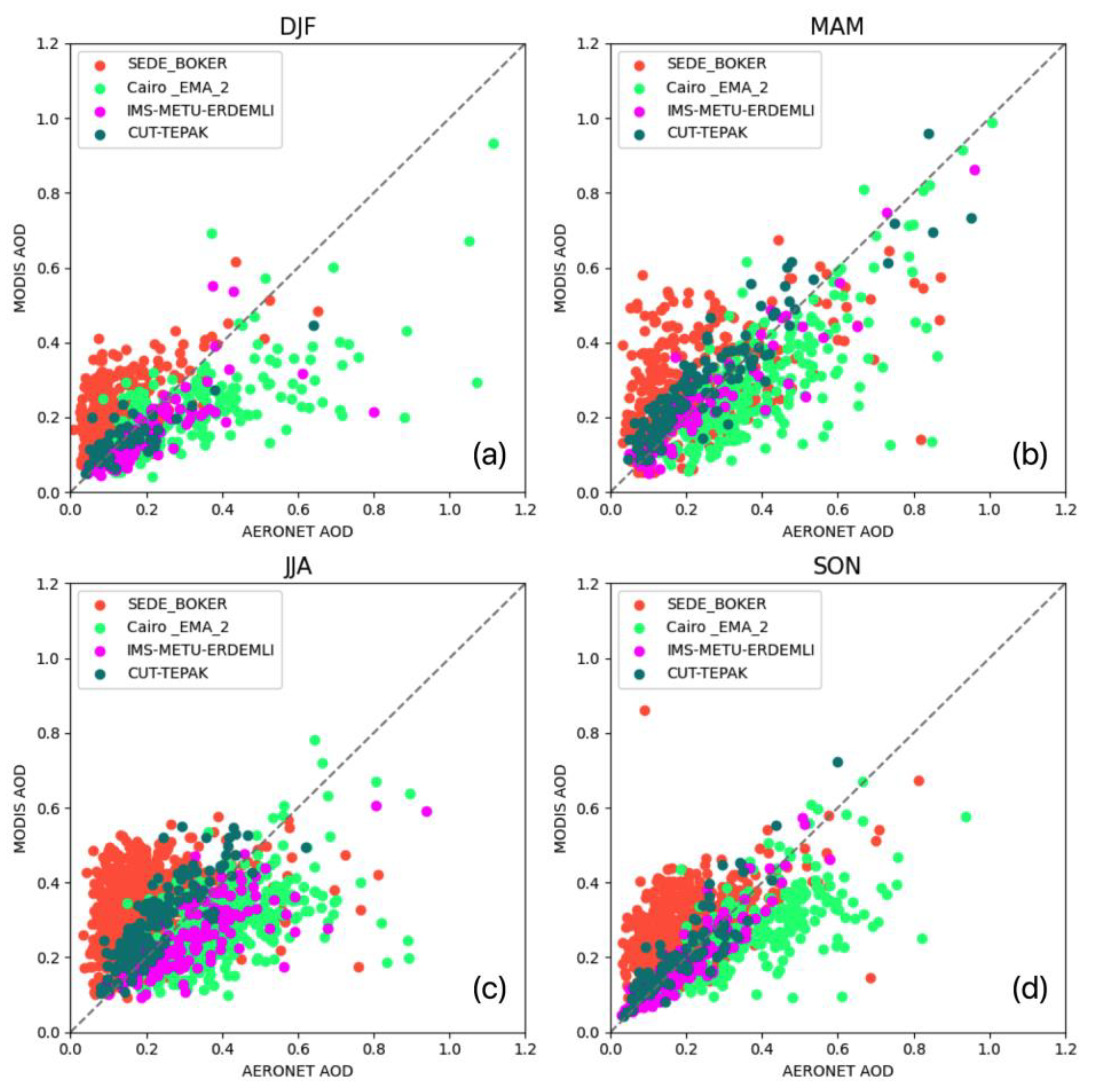
Figure 7 presents the relationship between AOD measurements from MODIS and AERONET data at four stations for different seasons. To investigate seasonality, four seasons are classified as winter (December, January, and February—DJF), spring (March, April, and May—MAM), summer (June, July, and August—JJA), and autumn (September, October, and November—SON). In winter (DJF), fewer data points are present compared to other seasons, suggesting less data collection during these months (Figure 7a), potentially due to higher cloud cover [40]. High AOD values were detected by both AERONET and MODIS (Figure 7b), as during spring (MAM). This increase in AOD values can primarily be attributed to the intensified transport of dust from significant deserts, such as the Arabian Peninsula and the Sahara, during spring [41,42]. For the summer season (JJA), as shown in Figure 7c, MODIS AOD readings are higher than the AERONET AOD values for points where AERONET reports AOD values less than 0.1. As depicted in Figure 7d, points suggest that MODIS has a tendency to both over- and underestimate AERONET AOD readings. Elevated AOD values documented during the September-to-November (SON) period at the Cairo station might be attributed to seasonal rice-straw burning (biomass burning) practiced by farmers in Cairo, a well-described phenomenon referred to as the Cairo “black cloud” [29].
The validation of MODIS-derived AOD with AERONET data across four stations reveals distinct behavioral patterns. Specifically, IMS-METU-ERDEMLI is classified as rural coastal, CUT-TEPAK as urban coastal, SEDE_BOKER as rural and semi-arid [43], and Cairo_EMA_2 as urban continental. Coastal regions like IMS-METU-ERDEMLI often experience a mixture of aerosol types, potentially affecting the agreement between MODIS and AERONET data [43]. This mixture could lead to more scatter in the validation graph compared to that observed at a purely marine or continental site. As an island station, CUT-TEPAK is expected to be influenced by marine aerosols. Additionally, it could experience long-range transport of aerosols from continental sources, leading to variations in AOD [44]. This might result in a validation graph with a tighter cluster around the 1:1 line compared to that seen in the graph for Erdemli, but with potential outliers during dust events (Figure 6). Cairo-EMA2, situated in a desert environment, is likely dominated by desert-dust aerosols, especially during spring and summer [39]. This could lead to a more systematic bias in the validation graph, specifically to either overestimation or underestimation by MODIS, depending on how well the MODIS algorithm retrieves dust properties in this region. Inland continental stations are more likely to be influenced by local and regional sources of aerosols, such as industrial emissions, dust from arid regions, and biomass burning. These areas might show stronger seasonal variations in AOD due to changes in these source strengths [39]. Therefore, SEDE_BOKER, located in the Negev Desert, is also expected to be influenced by dust aerosols. However, its position farther away from major dust sources compared to Cairo-EMA2 and potential influences from the Mediterranean Sea to the west might lead to different patterns in the validation graph.

3.2. Aerosol Distributions

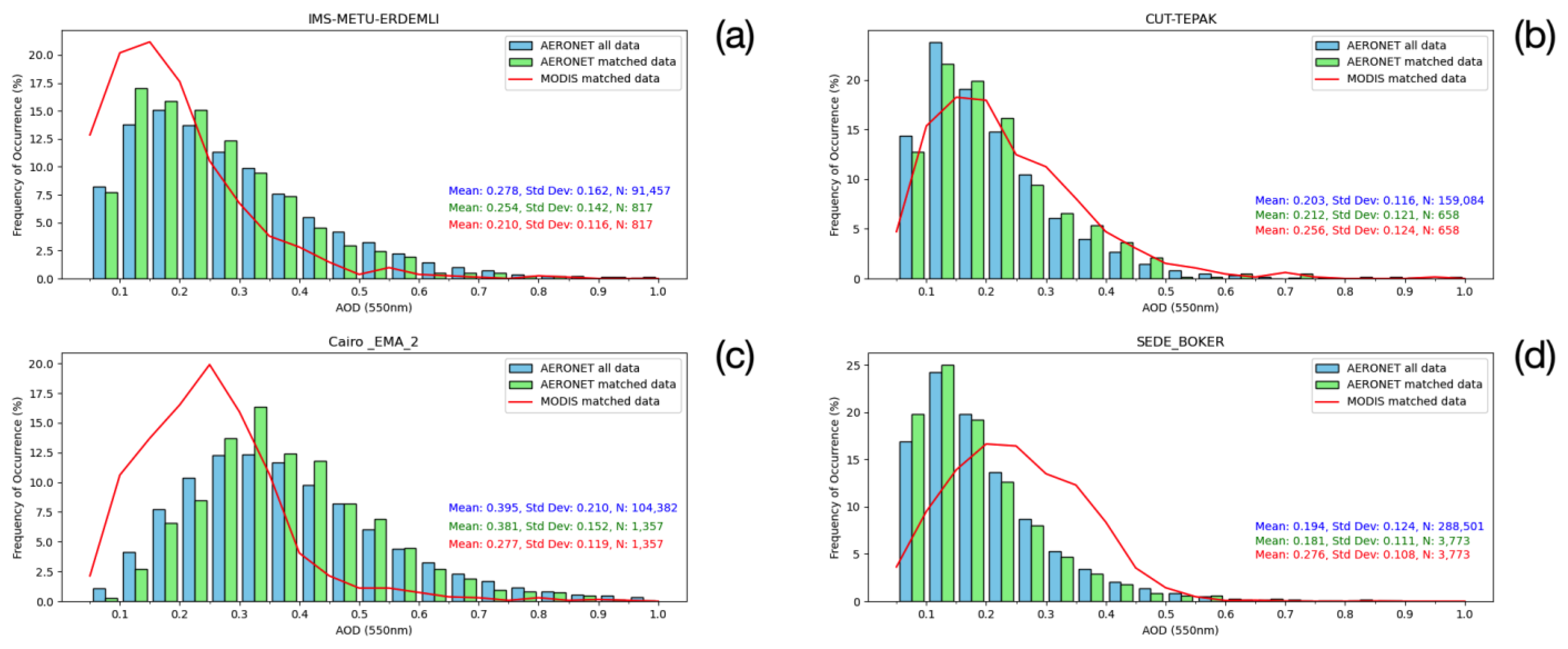
The procedure involves computing the average of all MODIS measurements within a 0.1° distance of an AERONET location (0.2° × 0.2° area). This aggregated dataset is described as “MODIS matched data”. Furthermore, the average of all AERONET measurements within a 30-min time range centered around the MODIS overpass time was calculated. For this comparative analysis, spatially averaged MODIS-Aqua measurements for the station subset area were evaluated against the temporally averaged AERONET measurements at each station. “AERONET all data” refers to all available data for the specified time period. “AERONET matched data” refers to averaged measurements over 30-min intervals, which are paired with “MODIS matched data”. “AERONET matched data” provides an aggregated value representative of atmospheric conditions during the MODIS overpass. Figure 8 show histograms of AERONET all data, AERONET matched data and MODIS matched data. The summary statistics of station measurements are also presented in Table 2.

3.2.1. Erdemli/Mersin

The histogram in Figure 8a illustrates the distribution of AOD measurements from MODIS and AERONET at METU-ERDEMLI station. The distribution of the AERONET all data, represented by the light blue bars, typically exhibits a higher frequency at lower AOD values, with a gradual decrease observed as the AOD values rise. The AERONET matched data (green bars) and MODIS matched data (red line) follow a similar distribution to the AERONET all data, but with slightly lower frequencies across AOD values greater than 0.3. The AERONET all data have a wider range of AOD values and higher variability, as indicated by the higher standard deviation, which is expected given the larger sample size. The matched datasets for AERONET and MODIS seem to be quite well aligned in terms of frequency distribution, which is not always the case when comparing ground-based (AERONET) and satellite (MODIS) measurements. MODIS tends to have a higher frequency of occurrence at lower AOD values (below 0.2) and a lower frequency at higher AOD values (particularly at values above 0.3).

3.2.2. Limassol/Cyprus

At CUT-TEPAK (Cyprus) station, unlike at Erdemli, the MODIS data for Cyprus show a higher mean AOD than the AERONET data. This deviation suggests either a difference in the retrieval algorithm of MODIS AOD or cloud contamination. MODIS might overestimate AOD due to cloud contamination. Alfaro-Contreras et al. [45] provide a good example of how the presence of clouds can significantly complicate MODIS AOD retrievals. This complexity often leads to inaccuracies, which can manifest as overestimations when compared to data collected under clearer conditions. Specifically, it would be useful to analyze how the retrieval algorithms used by MODIS, such as Dark Target and Deep Blue, might handle mixed or complex aerosol environments differently than the ground-based AERONET measurements. The MODIS mean AOD for Cyprus is higher than that for Erdemli (Figure 8b, Table 2).

3.2.3. Cairo/Egypt

At the Cairo_EMA_2 station, the distribution of MODIS matched data differs significantly from those of both sets of AERONET data (Figure 8c). The MODIS distribution exhibits a peak or higher frequency occurrence at a mid-range AOD values, then decreases for higher AOD measurements. This peak is not present in the AERONET all data, which shows a more gradual decline, without a pronounced peak. The greater mean AOD values for the AERONET all and matched data may suggest that a broader range of aerosol particles or conditions is captured by the ground-based instruments. The standard deviation is greater in Cairo’s AERONET all data.
Although it is expected that MODIS and AERONET capture the same conditions, discrepancies can be caused by several factors. These may include differences in the retrieval algorithms of MODIS AOD or issues related to cloud contamination. AERONET all data and matched data show higher mean AOD values (0.395 and 0.381, respectively) at Cairo compared to Erdemli’s AERONET all data and matched data (0.278 and 0.254) and Cyprus’s AERONET all data and matched data (0.194 and 0.181). This could indicate the presence of more aerosol in the atmosphere above Cairo or different aerosol properties.
The lower mean AOD values for MODIS in the Erdemli and Cairo locations indicate a potential systematic bias or difference in the methodology of satellite-based measurements versus ground-based observations. MODIS retrievals collocated with AERONET overestimate AERONET AOD at 0.05–0.35, while they underestimate AERONET AOD greater than 0.35. Aligning with our results, a study by Farahat et al. [46] shows that MODIS data retrievals represent Cairo’s climatology well, with a significant overestimation of AOD frequencies between 0.05 and 0.2 and an underestimation for AOD values greater than 0.4. The differences between our study and that of Farahat et al. [46] are primarily attributed to the use of MODIS data processed with the DB retrieval algorithm and the specific data-matching approach employed. In their study, MODIS data were averaged from measurements taken within a radius of approximately 27.5 km from the AERONET station and within 30 min of each satellite overpass. Furthermore, their study period, which spans the years 2010–2017, is shorter than the period covered in our research.

3.2.4. Sede Boker/Israel

SEDE-BOKER has the largest AERONET all data sample size among the locations compared and thus may offer stronger statistical confidence in the aerosol-distribution patterns for this region over time. MODIS matched data in Sede Boker, similar to that in Cyprus, has a notably different distribution pattern, with higher frequency percentages at mid-range AOD values compared to the ground-based data. MODIS matched AOD frequency significantly underestimates for AOD values less than 0.2 and overestimates for AOD values between 0.2 and 0.55 compared with AERONET retrievals. This discrepancy occurs because MODIS actually overestimates low AOD values because MODIS identifies some low-AOD cases (as per AERONET) as high-AOD cases (Figure 6).
The study covering four sites found that Sede Boker has the lowest frequency of AOD values greater than 0.4. This finding is supported by MODIS matched data. On the other hand, the AERONET station in Cairo has recorded the highest frequency of AOD measurements exceeding 0.4. Notably, MODIS satellite retrievals tend to underestimate these high AOD occurrences when compared to the ground-based AERONET observations in Cairo. The observations regarding AOD frequencies at Sede Boker and Cairo confirm the findings of Farahat et al. [46] study.

3.3. Aerosol Classsification

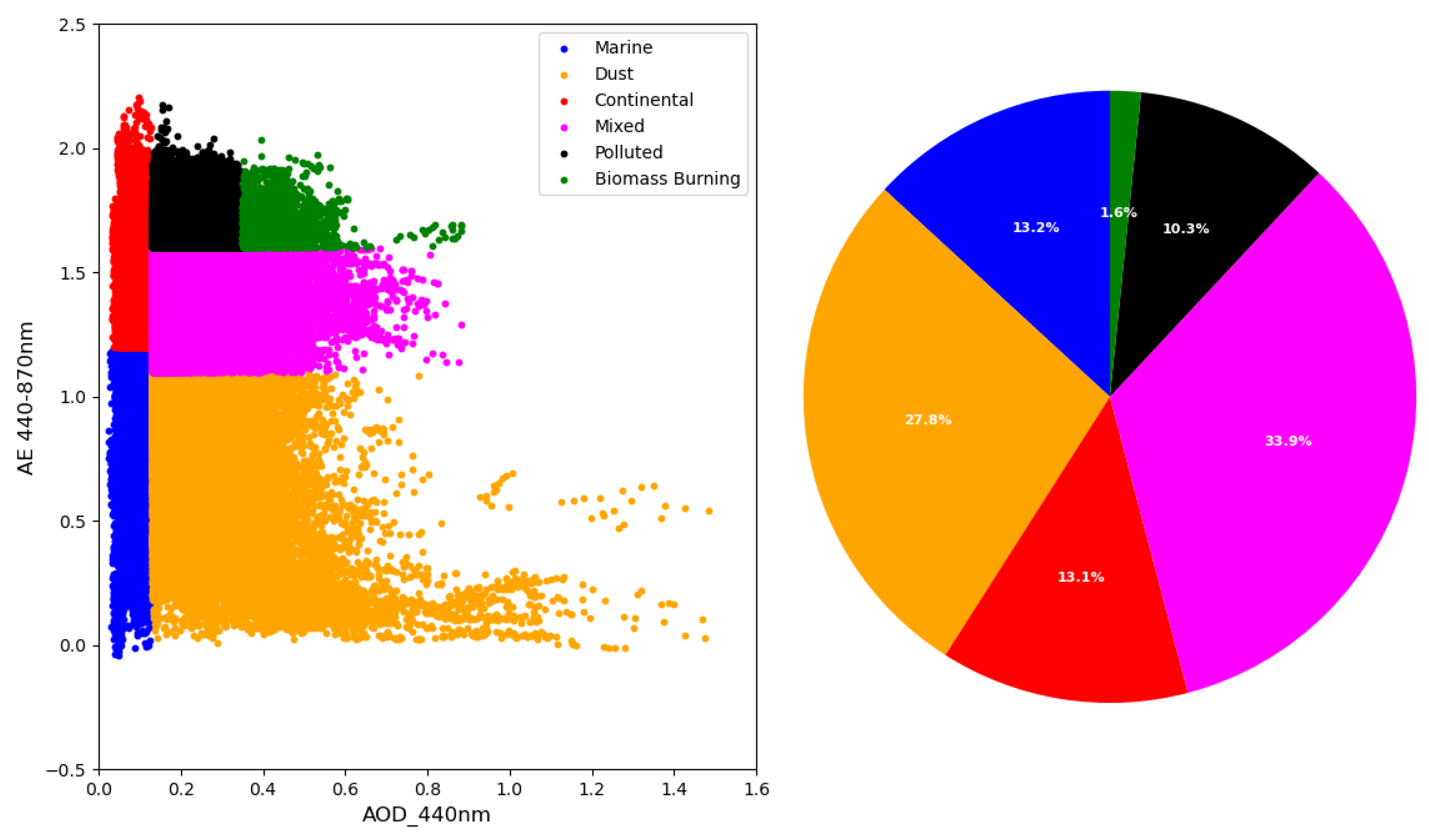
Figure 9, Figure 10, Figure 11 and Figure 12 present the aerosol classification results of four AERONET stations. The distribution of points provides information on the dominant aerosol types under various AOD conditions and size distributions (Blue: Marine, Red: Dust, Green: Continental, Magenta: Mixed, Black: Polluted, Yellow: Biomass Burning). Detailed results will be evaluated in sections of each station.
The pie chart labeled as Figure 9 shows that in Erdemli, mixed aerosols are the most observed type, accounting for 53% of the aerosol composition. The second dominant type after mixed aerosols, is desert dust, which accounts for 21.0% of the observations.
Compared to the previous pie chart of Erdemli (Figure 9), Figure 10 shows a different distribution, which can be attributed to the geographical and atmospheric differences between the two locations. Specifically, Cyprus is classified as urban coastal island, while Erdemli is classified as rural coastal. These regions experience distinct meteorological and environmental conditions, which influence the aerosol composition and distribution observed at each station. The varying distributions seen in Figure 9 and Figure 10 highlight how regional characteristics, such as urbanization, local pollution sources, and proximity to marine environments, impact aerosol properties. Figure 10 shows that mixed aerosols are the dominant aerosol type, accounting for 33.9% of the observations, followed closely by dust aerosols at 27.8%. Both IMS-METU-ERDEMLI and CUT-TEPAK stations observe coarse absorbing aerosols that originate from deserts located in the Anatolian Plateau, Arabian Peninsula, and North Africa [10,30,47]. At these sites, fine-mode particles are largely due to local pollution as well as pollutants transported from Central and Eastern Europe, Southeastern Europe, and the Eastern part of the Middle East-North Africa (MENA) region. A paper by Fountoulakis et al. [28] applies the same aerosol classification for the period 2010–2020, providing detailed insights into the types of aerosols present in Cyprus and their impact on solar radiation. The classification results are comparable to our findings for the period 2010–2023.
The pie chart, referred to as Figure 11, demonstrates that dust aerosols (61.4%) predominate in the region, constituting the majority of aerosol types observed, with mixed aerosols (35.5%) as the secondary significant aerosol category. The findings of El-Metwally et al. [48] reveal that Cairo’s aerosol composition includes “background pollution” aerosols originating from urban activities within the city, “pollution-like” aerosols from biomass burning in the Nile Delta, and “dust-like” aerosols generated by wind erosion in the Sahara.
Figure 12 shows the dominance of dust aerosols (43.5%) in the region; dust aerosols are followed by significant contributions from marine (22.1%) and mixed aerosols (20.6%).

3.4. Time-Series Analysis

3.4.1. Trend−Seasonality Analysis of MODIS

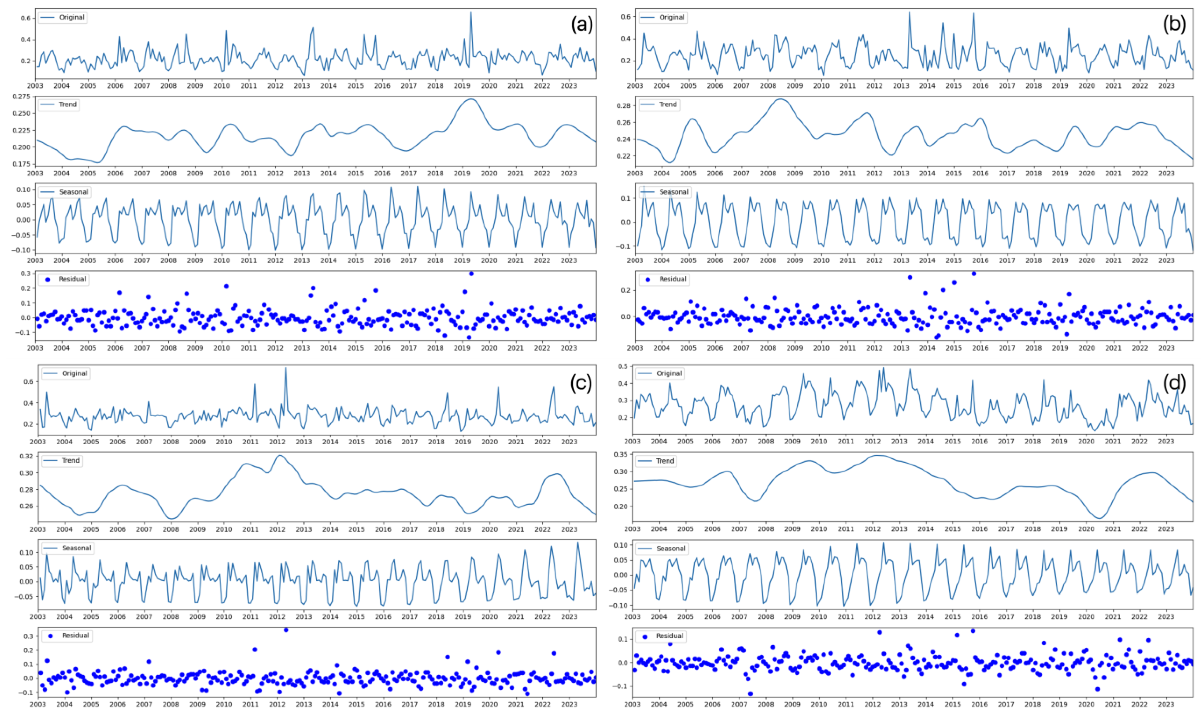
STL was applied to examine the long-term trends, seasonal patterns, and residual variations in the MODIS data for four stations. The trend component captures the long-term trend in the dataset, removing short-term fluctuations. The seasonal component captures the repeating annual cycle within the dataset, representing changes that occur within a year. Figure A2 in Appendix A illustrates trend, seasonality and residue decompositions for four locations over the period from 2003 to 2023. The Mann−Kendall test and Sen’s slope estimator were applied. For the IMS-METU-ERDEMLI station, a statistically significant slight positive trend in AOD values can be observed, with a slope of approximately 0.0001. In contrast, no significant trends could be detected at the other stations, namely CUT-TEPAK, Cairo_EMA_2, and SEDE_BOKER. The findings of Aslanoğlu et al. [13], using a 9-year CALIPSO-derived product (2007–2015), revealed the following station-specific trends: a slight positive trend at the IMS-METU-ERDEMLI, CUT-TEPAK, and Cairo_EMA_2 stations and a slight negative trend at the SEDE_BOKER station.
The trend at Erdemli/Mersin (Figure A2a) shows a gradual change over time, with increases around 2005–2007 and 2017–2020 that are followed by decreases. AOD values rise from 2017 to 2020, reaching a maximum around 2019. The seasonal component shows clear monthly variations, with high AOD values during spring and summer, likely due to increased mineral-dust activities [49,50], and lower AOD values during winter. Between 2015 and 2017, peaks can be observed earlier in spring and late summer, with the spring peak starting to increase until 2018.The period between 2018 and 2020 shows peaks in AOD values, particularly around 2019, which is consistent with the trend of increased aerosol levels during these years. Starting from 2017, seasonal peaks can be observed during late spring and summer.
Findings of seasonal pattern are consistent with the results from Kubilay et al. [10], which indicated that the northeastern Mediterranean receives significant dust particles from the Saharan desert in spring and from the central-eastern Sahara in summer. The region is affected by dust transported from Middle East—Arabian Peninsula in autumn. The study of Aldabash et al. [12] also concluded that AOD from MODIS observations peaks in the summer and reaches its lowest levels in the winter across the region. The increase in aerosol loadings over Turkey during the summer is due to the long-range transport of dust particles from the Middle East and North Africa. Tutsak and Koçak [49] suggested that the set of aerosol types was more diverse in spring compared to winter, summer, and fall.
The trend−seasonality analysis for Cyprus over the same period shows increases in AOD values between 2006–2009, 2010–2012, 2014–2016, and 2020–2022, with peaks around 2008 (the highest peak), 2011–2012 2016, and 2022 (Figure A2b). The seasonal component of the STL reveals a clear annual cycle, with peaks in late spring and summer. Lower AOD values can be observed in winter. Between 2003 and 2006, higher AOD values can be observed in the spring aerosol season. Despite these fluctuations, our analysis, utilizing MODIS data spanning from 2003 to 2023, did not identify any statistically significant trend at the CUT-TEPAK station.
In Cairo, from 2008 (a low point) to 2012 (peak), there is an increasing trend standing out in the analysis (Figure A2c). High AOD levels in 2006 might be attributed to the numerous fire events during the “black cloud” season [29]. Overall, the greatest value can be observed in 2012. After 2012, there is a decline in AOD values until 2019. High AOD values can be observed in late spring and summer (April to August), suggesting that seasonal dust transport is more active during these months [46]. Spring aerosol levels consistently higher than AOD values in summer. The lowest AOD value occured in winter (December to February), likely due to atmospheric cleansing by precipitation or reduced emissions. Moreover, between 2007 and 2015, two spring peaks can be observed, suggesting seasonal aerosol events during this period. Since 2019, spring peaks have been increasing while summer peaks have been declining, indicating a shift in seasonal aerosol dynamics. Analysis of Farahat et al. [46] with MODIS Aqua data from 2002 to 2014 revealed a positive trend, with a slope value of 0.001 per year.
Findings of El-Metwally et al. [48] align with our results, with dust-like aerosols with high AOD and low AE values observed in spring, indicating the presence of mineral dust from the southwest region, specifically the Saharan desert. The maximum AOD value in April includes both a mineral-dust component and background aerosol. High AOD values in summer might be due to pollution-like aerosols (fine-mode aerosols).
At the Sede-Boker station (Figure A2d), the trends indicate relatively stable AOD values from 2003 to 2006, and from 2015 to 2019. A period of increasing AOD values can be observed between 2007 and 2012, peaking around 2012. The lowest AOD values occurred around 2020.The dominance of spring peaks over summer peaks is noticeable from 2006 onward. Since 2017, spring maxima have remained steady, while summer peaks have been decreasing. From 2003 to 2012, spring peaks start to increase, with the highest AOD values observed in spring 2012, coinciding with the overall maxima. Consistent with other stations, lower aerosol concentrations can be observed in winter. From 2012 onwards, the winter minimum values started to increase, while the summer peaks increased from 2012 to 2018 and then decreased.
Both Cairo and Sede Boker experienced peaks in AOD values around 2012, with those peaks followed by a decreasing trend in AOD values and a new peak around 2022.
This indicates that these two stations, situated in the southern part of the Levantine region, may have been influenced by similar regional factors such as meteorological conditions, dust-transport mechanisms, and changes in local emission sources.

3.4.2. Comparative Trend Analysis of MODIS and AERONET AOD Measurements

MODIS and AERONET observations across all stations were compared to assess how well they capture general climatological patterns and trends in AOD using the STL method (Figure 13). In each station, quality-assured measurements start and end on different dates. For this reason, different time windows are presented for each station, but evaluations have also been carried out for the concurrent measurements. Over the period from 2004 to 2019 at the IMS-METU-ERDEMLI station (Figure 13a), both datasets capture major peaks and general trends, although AERONET tends to show higher AOD values. The trend between 2006 and 2011 closely matches, showing similar patterns during this period. The trend analysis reveals an AERONET peak in 2012; however, this peak is not reflected in the MODIS data. The highest value observed in the AERONET data is in 2014, whereas this peak is not the highest in the MODIS data. Moreover, the MODIS trend overestimates AOD values compared to the AERONET trend in 2019.
Over the period from 2010 to 2023 at the CUT-TEPAK station (Figure 13b), MODIS data shows higher peaks and greater variability compared to the more subdued trends observed in AERONET data. On the other hands, at the Cairo_EMA_2 station over the same period (Figure 13c), the AERONET data includes higher peaks and more apparent fluctuations compared to the MODIS data. The maximum in 2013 is remarkably more pronounced than in the MODIS data. Over the period from 2003 to 2023 at the SEDE_BOKER station (Figure 13d), excluding the year 2020, MODIS AOD values are predominantly higher than AERONET values. Both the MODIS and the AERONET data show similar peaks and fluctuations, particularly around 2016–2023.

4. Conclusions

This study reveals comparative AOD measurements obtained from Aqua/MODIS and IMS-METU-ERDEMLI, CUT-TEPAK, Cairo_EMA_2, and SEDE_BOKER AERONET stations located in the Levantine Basin, over different periods between 2003 and 2023.
The comparison between the Aqua/MODIS AOD measurements and the AERONET data at four stations (IMS-METU-ERDEMLI, CUT-TEPAK, Cairo_EMA_2, and SEDE-BOKER) highlight the accuracy and limitations of MODIS observations (Figure 2, Figure 3, Figure 4 and Figure 5). The results indicate that the MODIS and AERONET data align well, with the highest percentage of measurements within the expected EE observed at the IMS-METU-ERDEMLI station, where the R2 value was recorded as 0.7442. The highest R2 value was recorded at CUT-TEPAK (R2 = 0.7496), where 70.52% of data points fall within the EE, though MODIS showed notable overestimation tendencies. In Cairo, 51.66% of measurements fall within the EE, but MODIS underestimates overall AERONET values, especially for high AOD values. The RMSE is relatively high, at 0.1585, indicating moderate agreement. The reliability of MODIS AOD measurements is higher at low cloud fractions (0–0.3), with increased variability and inaccuracies at higher cloud fractions.
Results for the period between 2010 to 2019 show unique patterns and seasonal variations across those stations, as depicted in Figure 6 and Figure 7. MODIS generally overestimates AOD values at the SEDE_BOKER station and underestimates them at the Cairo station. Additionally, it shows good agreement with AERONET observations at the CUT-TEPAK station in Cyprus. Seasonal variations are evident, with high AOD values peaking during the spring duststorm season and notable differences in AOD readings during the winter and summer months.
The aerosol classification using AOD and AE data from AERONET stations identifies the dominant aerosol types at each station (Figure 9, Figure 10, Figure 11 and Figure 12). At both IMS-METU-ERDEMLI and CUT-TEPAK (Cyprus), mixed aerosols are dominant, accounting for 53% and 33.9% of the aerosol composition, respectively; mixed aerosols are followed by dust aerosols, at 21% and 27.8%, respectively, reflecting the influence of deserts and local pollution. In Cairo, dust aerosols are predominant (61.4%), with mixed aerosols also notable (35.5%), highlighting contributions from urban pollution, biomass burning, and Saharan dust. At SEDE-BOKER, dust aerosols dominate (43.5%) and are followed by marine (22.1%) and mixed aerosols (20.6%), indicating the impact of both local and remote sources on aerosol composition.
The STL analysis of the MODIS data for four stations reveals long-term trends, seasonal patterns, and residual variations over the period from 2003 to 2023 (Figure A2 in Appendix A). All stations display distinct patterns, reflecting their unique regional aerosol sources and transport mechanisms. Seasonal analysis shows consistent peaks in AOD during spring and summer, which are mainly influenced by dust transport from the Sahara and the Middle East. In contrast, lower AOD values can be seen in the winter months. Our analysis demonstrates significant seasonal variability and long-term trends in AOD measurements. The trend products derived from the STL method for the MODIS and AERONET observations were compared across four stations (Figure 13) to assess how well they capture general climatological patterns and trends in AOD.
Through detailed analysis, this study deepens our understanding of aerosol behavior in the Levantine Region. While this study is not the first to analyze the region, it is the first to employ an extended time series of data from MODIS and AERONET. The distinct behaviors observed at each station require a broader examination in relation to meteorological conditions, topography, and land-surface characteristics. Future research efforts could be greatly improved by incorporating AOD data from both the Terra MODIS and VIIRS (Visible Infrared Imaging Radiometer Suite) instruments. The integration of these additional datasets would enable a more comprehensive analysis of aerosol distribution and trends. Furthermore, future studies including collocated chemical analyses, different sensors, models, and trajectory analyses, will enhance our understanding of aerosol characteristics in the region.

Author Contributions

Conceptualization, A.G.I., S.Y.A. and G.G.; methodology, A.G.I., S.Y.A. and G.G.; software, A.G.I.; validation, A.G.I., S.Y.A. and G.G.; formal analysis, A.G.I., S.Y.A. and G.G.; investigation, A.G.I., S.Y.A. and G.G.; resources, A.G.I., S.Y.A. and G.G.; data curation, A.G.I., S.Y.A. and G.G.; writing—original draft preparation, A.G.I., S.Y.A. and G.G.; writing—review and editing, A.G.I., S.Y.A. and G.G.; visualization, A.G.I.; supervision, S.Y.A. and G.G. All authors have read and agreed to the published version of the manuscript.

Funding

This research received no external funding.

Data Availability Statement

MODIS data are publicly available at NASA Atmosphere Archive and Distribution System (LAADS) website (https://ladsweb.modaps.eosdis.nasa.gov/, accessed on 16 January 2024) via Distributed Active Archive Center (DAAC). AERONET data are also publicly available at AERONET data base (https://aeronet.gsfc.nasa.gov/, accessed on 20 January 2024).

Acknowledgments

This publication is a part of the first author’s doctoral dissertation.

Conflicts of Interest

The authors declare no conflicts of interest. The funders had no role in the design of the study; in the collection, analyses, or interpretation of data; in the writing of the manuscript, or in the decision to publish the results.

Appendix A

Figure A1. Scatterplot of MODIS AOD versus AERONET AOD for different cloud-fraction intervals (CF) across four different sites: (ac) IMS-METU-ERDEMLI, (df) CUT-TEPAK, (gi) Cairo_EMA, and (jl) SEDE_BOKER. Each station was analyzed for three cloud-fraction intervals: CF (0–0.3), CF (0.3–0.6), and CF (0.6–1.0).
Remotesensing 16 02651 g0a1
Table A1. Summary of statistical analysis results of MODIS and AERONET AOD measurements for each station at low cloud-fraction values (0–0.3).
CF (0–0.3)IMS-METU-ERDEMLICUT-TEPAKCairo_EMA_2SEDE_BOKER
N67751411341758
R0.85470.88190.65850.4656
R20.73050.77780.43360.2168
Regression equationy = 0.72x + 0.03y = 0.90x + 0.06y = 0.53x + 0.08y = 0.42x + 0.20
RMSE0.07990.07490.16050.1305
%within EE94.2486.3881.2260.52
%above EE3.258.1710.4118.49
%below EE2.515.458.3820.99
Figure A2. STL decomposition of MODIS AOD time-series data at 550 nm for four different sites: (a) IMS-METU-ERDEMLI, (b) CUT-TEPAK, (c) Cairo_EMA_2, and (d) SEDE_BOKER. Each subplot includes the original data, trend component, seasonal component, and residuals from 2003 to 2023.
Remotesensing 16 02651 g0a2

References

  1. Bangert, M.; Nenes, A.; Vogel, B.; Vogel, H.; Barahona, D.; Karydis, V.; Kumar, P.; Kottmeier, C.; Blahak, U. Saharan dust event impacts on cloud formation and radiation over Western Europe. Atmos. Chem. Phys. 2012, 12, 4045–4063. [Google Scholar] [CrossRef]
  2. Arfin, T.; Pillai, A.M.; Mathew, N.; Tirpude, A.; Bang, R.; Mondal, P. An overview of atmospheric aerosol and their effects on human health. Environ. Sci. Pollut. Res. 2023, 30, 125347–125369. [Google Scholar] [CrossRef] [PubMed]
  3. Holben, B.N.; Slutsker, T.I.E.I.; Tar, D.; Buis, J.P.; Setxerj, I.I.A.; Reagan, A.; Kaufman, Y.J.; Nakajima, T.; Lavenu, F.; Vemte, E.; et al. AERONET-A Federated Instrument Network and Data Archive for Aerosol Characterization. Remote Sens. Environ. 1998, 16, 1–16. [Google Scholar] [CrossRef]
  4. Merdji, A.B.; Xu, X.; Lu, C.; Habtemicheal, B.A.; Li, J. Accuracy assessment and climatology of MODIS aerosol optical properties over North Africa. Environ. Sci. Pollut. Res. 2023, 30, 13449–13468. [Google Scholar] [CrossRef]
  5. Yu, H.; Dickinson, R.E.; Chin, M.; Kaufman, Y.J.; Holben, B.N.; Geogdzhayev, I.V.; Mishchenko, M.I. Annual cycle of global distributions of aerosol optical depth from integration of MODIS retrievals and GOCART model simulations. J. Geophys. Res. Atmos. 2003, 108, 1–14. [Google Scholar] [CrossRef]
  6. Liu, H.; Pinker, R.T.; Holben, B.N. A global view of aerosols from merged transport models, satellite, and ground observations. J. Geophys. Res. Atmos. 2005, 110, 1–16. [Google Scholar] [CrossRef]
  7. Prospero, J.M.; Ginoux, P.; Torres, O.; Nicholson, S.E.; Gill, T. Environmental Characterization of Global Sources of Atmospheric Soil Dust Identified with the Nimbus 7 Total Ozone Mapping Spectrometer (TOMS) Absorbing Aerosol Product. Rev. Geophys. 2002, 40, 1002. [Google Scholar] [CrossRef]
  8. Middleton, N.; Tozer, P.; Tozer, B. Sand and dust storms: Underrated natural hazards. Disasters 2019, 43, 390–409. [Google Scholar] [CrossRef]
  9. Özsoy, E.; Kubilay, N.; Nickovic, S.; Moulin, C. A Hemispheric Dust Storm Affecting the Atlantic and Mediterranean in April 1994: Analyses, Modeling, Ground-Based Measurements and Satellite Observations. J. Geophys. Res. 2001, 106, 18439–18460. [Google Scholar] [CrossRef]
  10. Kubilay, N.; Oğuz, T.; Koçak, M.; Torres, O. Ground-based assessment of total ozone mapping spectrometer (TOMS) data for dust transport over the northeastern Mediterranean. Glob. Biogeochem. Cycles 2005, 19, 1. [Google Scholar] [CrossRef]
  11. Hatzianastassiou, N.; Gkikas, A.; Mihalopoulos, N.; Torres, O.; Katsoulis, B.D. Natural versus Anthropogenic Aerosols in the Eastern Mediterranean Basin Derived from Multiyear TOMS and MODIS Satellite Data. J. Geophys. Res. Atmos. 2009, 114. [Google Scholar] [CrossRef]
  12. Aldabash, M.; Balçık, F.B.; Glantz, P. Validation of MODIS C6.1 and MERRA-2 AOD using AERONET observations: A comparative study over Turkey. Atmosphere 2020, 11, 905. [Google Scholar] [CrossRef]
  13. Aslanoğlu, S.Y.; Proestakis, E.; Gkikas, A.; Güllü, G.; Amiridis, V. Dust Climatology of Turkey as a Part of The Eastern Mediterranean Basin via 9-Year CALIPSO-Derived Product. Atmosphere 2022, 13, 733. [Google Scholar] [CrossRef]
  14. Remer, L.; Kaufman, Y.; Tanré, D.; Mattoo, S.; Chu, D.; Martins, J.; Holben, B. The MODIS aerosol algorithm, products, and validation. J. Atmos. Sci. 2005, 62, 947–973. [Google Scholar] [CrossRef]
  15. Levy, R.; Remer, L.; Kleidman, R.; Mattoo, S.; Ichoku, C.; Kahn, R.; Eck, T. Global evaluation of the collection 5 MODIS dark-target aerosol products over land. Atmos. Chem. Phys. 2010, 10, 10399–10420. [Google Scholar] [CrossRef]
  16. Dubovik, O.; Holben, B.; Eck, T.F.; Smirnov, A.; Kaufman, Y.J.; King, M.D.; Tanré, D.; Slutsker, I. Variability of Absorption and Optical Properties of Key Aerosol Types Observed in Worldwide Locations. J. Atmos. Sci. 2002, 59, 590–608. [Google Scholar] [CrossRef]
  17. Wu, Y.; Graaf, M.; Menenti, M. The sensitivity of AOD retrieval to aerosol type and vertical distribution over land with MODIS data. Remote Sens. 2016, 8, 765. [Google Scholar] [CrossRef]
  18. Verma, S.; Prakash, D.; Soni, M.; Ram, K. Atmospheric Aerosols Monitoring: Ground and Satellite-Based Instruments. In Advances in Environmental Monitoring and Assessment; IntechOpen: London, UK, 2019. [Google Scholar] [CrossRef]
  19. Levy, R.C.; Mattoo, S.; Munchak, L.A.; Sayer, A.M.; Patadia, F.; Hsu, N.C. The Collection 6 MODIS aerosol products over land and ocean. Atmos. Meas. Technol. 2013, 6, 2989–3034. [Google Scholar] [CrossRef]
  20. Hsu, N.C.; Jeong, M.-J.; Bettenhausen, C.; Sayer, A.M.; Hansell, R.; Seftor, C.S.; Huang, J.; Tsay, S.-C. Enhanced Deep Blue aerosol retrieval algorithm: The second generation. J. Geophys. Res. Atmos. 2013, 118, 9296–9315. [Google Scholar] [CrossRef]
  21. Lyapustin, A.; Martonchik, J.; Wang, Y.; Laszlo, I.; Korkin, S. Multiangle implementation of atmospheric correction (MAIAC): 1. Radiative transfer basis and look-up tables. J. Geophys. Res. 2011, 116, D03210. [Google Scholar] [CrossRef]
  22. Sayer, A.M.; Munchak, L.A.; Hsu, N.C.; Levy, R.C.; Bettenhausen, C.; Jeong, M. MODIS collection 6 aerosol products: Comparison between Aqua’s e-Deep Blue, Dark Target, and “merged” data sets, and usage recommendations. J. Geophys. Res. Atmos. 2014, 119, 13–965. [Google Scholar] [CrossRef]
  23. Remer, L.A.; Kleidman, R.G.; Levy, R.C.; Kaufman, Y.J.; Tanré, D.; Mattoo, S.; Martins, J.V.; Ichoku, C.; Koren, I.; Yu, H.; et al. Global aerosol climatology from the MODIS satellite sensors. J. Geophys. Res. 2008, 113, D14S07. [Google Scholar] [CrossRef]
  24. Dubovik, O.A.; Smirnov, A.; Holben, B.N.; King, M.D.; Kaufman, Y.J.; Eck, T.F.; Slutsker, I. Accuracy assessments of aerosol optical properties retrieved from aerosol robotic network (AERONET) sun and sky radiance measurements. J. Geophys. Res. Atmos. 2000, 105, 9791–9806. [Google Scholar] [CrossRef]
  25. Giles, D.; Sinyuk, A.; Sorokin, M.; Schafer, J.; Smirnov, A.; Slutsker, I.; Eck, T.F.; Holben, B.N.; Lewis, J.R.; Campbell, J.R.; et al. Advancements in the aerosol robotic network (AERONET) version 3 database—Automated near-real-time quality control algorithm with improved cloud screening for sun photometer aerosol optical depth (AOD) measurements. Atmos. Meas. Technol. 2019, 12, 169–209. [Google Scholar] [CrossRef]
  26. Eck, T.F.; Holben, B.N.; Reid, J.S.; Dubovik, O.; Smirnov, A.; O’Neill, N.T.; Slutsker, I.; Kinne, S. Wavelength dependence of the optical depth of biomass burning, urban, and desert dust aerosols. J. Geophys. Res. 1999, 104, 31333–31349. [Google Scholar] [CrossRef]
  27. Angstrom, A. On the atmospheric transmission of Sun radiation and on dust in the air. Geogr. Ann. 1929, 12, 130–159. [Google Scholar]
  28. Fountoulakis, I.; Kosmopoulos, P.; Papachristopoulou, K.; Raptis, I.-P.; Mamouri, R.-E.; Nisantzi, A.; Gkikas, A.; Witthuhn, J.; Bley, S.; Moustaka, A.; et al. Effects of Aerosols and Clouds on the Levels of Surface Solar Radiation and Solar Energy in Cyprus. Remote Sens. 2021, 13, 2319. [Google Scholar] [CrossRef]
  29. Marey, H.; Gille, J.; El-Askary, H.; Shalaby, E.; El-Raey, M. Study of the formation of the “black cloud” and its dynamics over Cairo, Egypt, using MODIS and MISR sensors. J. Geophys. Res. 2010, 115, D21206. [Google Scholar] [CrossRef]
  30. Derimian, Y.; Karnieli, A.; Kaufman, Y.J.; Andreae, M.O.; Andreae, T.W.; Dubovik, O.; Maenhaut, W.; Koren, I.; Holben, B.N. Dust and pollution aerosols over the Negev desert, Israel: Properties, transport, and radiative effect. J. Geophys. Res. Atmos. 2006, 111, D5. [Google Scholar] [CrossRef]
  31. Derimian, Y.; Choël, M.; Rudich, Y.; Deboudt, K.; Dubovik, O.; Laskin, A.; Legrand, M.; Damiri, B.; Koren, I.; Unga, F.; et al. Effect of sea breeze circulation on aerosol mixing state and radiative properties in a desert setting. Atmos. Chem. Phys. Discuss. 2017, 17, 11331–11353. [Google Scholar] [CrossRef]
  32. Andreae, T.W.; Andreae, M.O.; Ichoku, C.; Maenhaut, W.; Cafmeyer, J.; Karnieli, A.; Orlovsky, L. Light scattering by dust and anthropogenic aerosol at a remote site in the Negev desert, Israel. J. Geophys. Res.-Atmos. 2002, 107, 4008. [Google Scholar] [CrossRef]
  33. Sciare, J.; d’Argouges, O.; Zhang, Q.J.; Sarda-Estève, R.; Gaimoz, C.; Gros, V.; Beekmann, M.; Sanchez, O. Comparison between simulated and observed chemical composition of fine aerosols in Paris (France) during springtime: Contribution of regional versus continental emissions. Atmos. Chem. Phys. 2010, 10, 11987–12004. [Google Scholar] [CrossRef]
  34. Pace, G.; di Sarra, A.; Meloni, D.; Piacentino, S.; Chamard, P. Aerosol optical properties at Lampedusa (Central Mediterranean). 1. Influence of transport and identification of different aerosol types. Atmos. Chem. Phys. 2006, 6, 697–713. [Google Scholar] [CrossRef]
  35. Toledano, C.; Cachorro, V.E.; Berjon, A.; de Frutos, A.M.; Sorribas, M.; de la Morena, B.A.; Goloub, P. Aerosol optical depth and Ångström exponent climatology at El Arenosillo AERONET site (Huelva, Spain). Q. J. R. Meteorol. Soc. 2007, 133, 795–807. [Google Scholar] [CrossRef]
  36. Cleveland, R.B.; Cleveland, W.S.; McRae, J.E.; Terpenning, I. STL: A Seasonal-Trend Decomposition Procedure Based on Loess. J. Off. Stat. 1990, 6, 3–73. [Google Scholar]
  37. Toth, T.D.; Zhang, J.; Campbell, J.R.; Reid, J.S.; Shi, Y.; Johnson, R.S.; Smirnov, A.; Vaughan, M.A.; Winker, D.M. Investigating enhanced Aqua MODIS aerosol optical depth retrievals over the mid-to-high latitude Southern Oceans through intercomparison with co-located CALIOP, MAN, and AERONET data sets. J. Geophys. Res. Atmos. 2013, 118, 4700–4714. [Google Scholar] [CrossRef]
  38. Wang, Y.; Yuan, Q.; Li, T.; Shen, H.; Zheng, L.; Zhang, L. Evaluation and comparison of MODIS Collection 6.1 aerosol optical depth against AERONET over regions in China with multifarious underlying surfaces. Atmos. Environ. 2019, 200, 280–301. [Google Scholar] [CrossRef]
  39. Gavrouzou, M.; Hatzianastassiou, N.; Gkikas, A.; Lolis, C.J.; Mihalopoulos, N. A Climatological Assessment of Intense Desert Dust Episodes over the Broader Mediterranean Basin Based on Satellite Data. Remote Sens. 2021, 13, 2895. [Google Scholar] [CrossRef]
  40. Eck, T.; Holben, B.; Reid, J.; Xian, P.; Giles, D.; Sinyuk, A.; Xia, X. Observations of the interaction and transport of fine mode aerosols with cloud and/or fog in northeast Asia from aerosol robotic network and satellite remote sensing. J. Geophys. Res. Atmos. 2018, 123, 5560–5587. [Google Scholar] [CrossRef]
  41. Mao, K.B.; Ma, Y.; Xia, L.; Chen, W.Y.; Shen, X.Y.; He, T.J.; Xu, T.R. Global aerosol change in the last decade: An analysis based on MODIS data. Atmos. Environ. 2014, 94, 680–686. [Google Scholar] [CrossRef]
  42. Rodriguez, S.; Querol, X.; Alastuey, A.; Plana, F. Sources and processes affecting levels and composition of atmospheric aerosol in the western Mediterranean. J. Geophys. Res. 2002, 107, AAC-12. [Google Scholar] [CrossRef]
  43. Georgoulias, A.K.; Alexandri, G.; Kourtidis, K.; Lelieveld, J.; Zanis, P.; Pöschl, U.; Tsikerdekis, A. Spatiotemporal variability and contribution of different aerosol types to the aerosol optical depth over the eastern Mediterranean. Atmos. Chem. Phys. 2016, 16, 13853–13884. [Google Scholar] [CrossRef] [PubMed]
  44. Logothetis, S.-A.; Salamalikis, V.; Kazantzidis, A. Aerosol classification in Europe, Middle East, North Africa and Arabian Peninsula based on AERONET Version 3. Atmos. Res. 2020, 239, 104893. [Google Scholar] [CrossRef]
  45. Alfaro-Contreras, R.; Zhang, J.; Campbell, J.R.; Holz, R.E.; Reid, J.S. Evaluating the impact of aerosol particles above cloud on cloud optical depth retrievals from MODIS. J. Geophys. Res. Atmos. 2014, 119, 5410–5423. [Google Scholar] [CrossRef]
  46. Farahat, A. Comparative analysis of MODIS, MISR, and AERONET climatology over the Middle East and North Africa. Ann. Geophys. 2019, 37, 49–64. [Google Scholar] [CrossRef]
  47. Basart, S.; Pérez, C.; Cuevas, E.; Baldasano, J.M.; Gobbi, G.P. Aerosol characterization in Northern Africa, Northeastern Atlantic, Mediterranean Basin and Middle East from direct-sun AERONET observations. Atmos. Chem. Phys. 2009, 9, 8265–8282. [Google Scholar] [CrossRef]
  48. El-Metwally, M.; Alfaro, S.C.; Abdel Wahab, M.; Chatenet, B. Aerosol characteristics over urban Cairo: Seasonal variations as retrieved from Sun photometer measurements. J. Geophys. Res. 2008, 113, D14219. [Google Scholar] [CrossRef]
  49. Tutsak, E.; Koçak, M. Long-term measurements of aerosol optical and physical properties over the Eastern Mediterranean: Hygroscopic nature and source regions. Atmos. Environ. 2019, 207, 1–15. [Google Scholar] [CrossRef]
  50. Tutsak, E.; Koçak, M. Optical and microphysical properties of the columnar aerosol burden over the Eastern Mediterranean: Discrimination of aerosol types. Atmos. Environ. 2020, 229, 117463. [Google Scholar] [CrossRef]
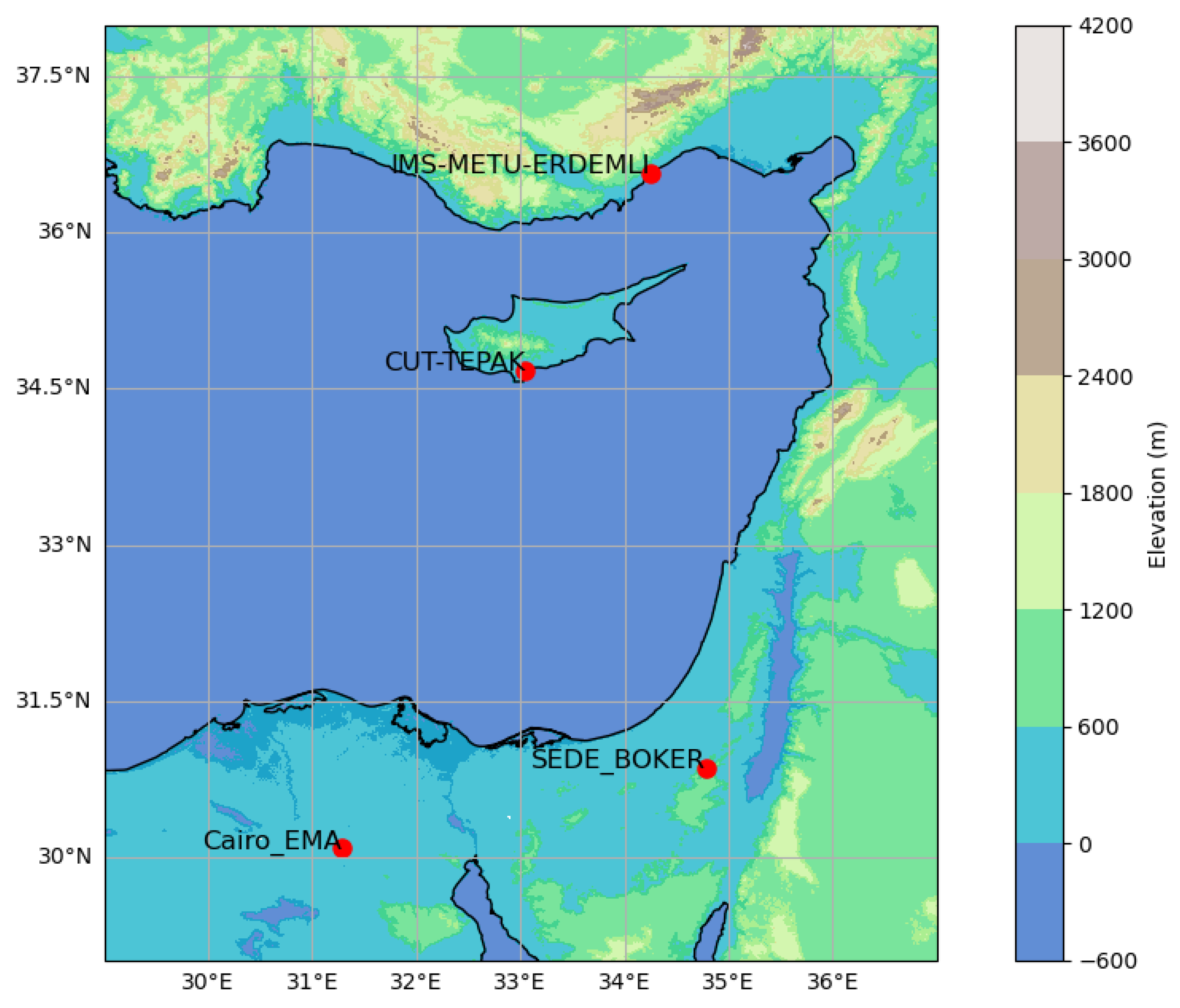
Figure 1. Levantine Region with the AERONET stations used for the study.
Remotesensing 16 02651 g001
Figure 2. MODIS AOD versus AERONET AOD at Erdemli Station from 2004 to 2019. The red line is the regression line, and the green dashed lines define the envelope of expected error (EE). Colors of the points represent the cloud-fraction range associated with MODIS measurements.
Remotesensing 16 02651 g002
Figure 3. MODIS AOD versus AERONET AOD at Cyprus station from 2010 to 2023. The red line is the regression line, and the green dashed lines define the envelope of expected error (EE). Colors of the points represent the cloud-fraction range associated with MODIS measurements.
Remotesensing 16 02651 g003
Figure 4. MODIS AOD versus AERONET AOD at Cairo station from 2010 to 2023. The red line is the regression line, and the green dashed lines define the envelope of expected error (EE). Colors of the points represent the cloud-fraction range associated with MODIS measurements.
Remotesensing 16 02651 g004
Figure 5. MODIS AOD versus AERONET AOD at Sede Boker station from 2003 to 2023. The red line is the regression line, and the green dashed lines define the envelope of expected error (EE). Colors of the points represent the cloud-fraction range associated with MODIS measurements.
Remotesensing 16 02651 g005
Figure 6. Comparison of AOD measurements from MODIS to those from AERONET at IMS-METU-ERDEMLI, CUT-TEPAK, Cairo_EMA_2, and SEDE_BOKER stations over a decade, from 2010 to 2019.
Remotesensing 16 02651 g006
Figure 7. Seasonal comparison between MODIS and AERONET AOD measurements across four locations. The seasons are abbreviated as (a) DJF (December, January, February), (b) MAM (March, April, May), (c) JJA (June, July, August), and (d) SON (September, October, November).
Remotesensing 16 02651 g007
Figure 8. Histograms of the MODIS and AERONET measurements at 550 nm Across Different AERONET Stations: (a) IMS-METU-ERDEMLI, (b) CUT-TEPAK, (c) Cairo_EMA_2, (d) SEDE_BOKER.
Remotesensing 16 02651 g008
Figure 9. Aerosol classification for the IMS-METU-ERDEMLI station in Erdemli/Mersin (Time period: 2004–2019).
Remotesensing 16 02651 g009
Figure 10. Aerosol classification for the CUT-TEPAK station in Limassol/Cyprus (Time period: 2010–2023).
Remotesensing 16 02651 g010
Figure 11. Aerosol classification for the Cairo_EMA_2 station in Cairo/Egypt (Time period: 2010–2023).
Remotesensing 16 02651 g011
Figure 12. Aerosol classification for the SEDE_BOKER station in Sede Boker/Israel (Time period: 2003–2023).
Remotesensing 16 02651 g012
Figure 13. Trends in MODIS and AERONET AOD at 550 nm for four different stations: (a) IMS-METU-ERDEMLI (2004–2019), (b) CUT-TEPAK (2010–2023), (c) Cairo_EMA_2 (2010–2023), and (d) SEDE_BOKER (2003–2023).
Remotesensing 16 02651 g013
Table 1. Information about AERONET stations used in this study.
Station NameCity/CountryCoordinates
Latitude/Longitude
ElevationMeasurement
Period
IMS-METU-ERDEMLI Mersin/Türkiye36.565N/34.255E3 m1999–2019
CUT-TEPAKLimassol/Cyprus34.675N/33.043E22 m2010–2023
Cairo_EMA_2Cairo/Egypt30.081N/31.290E70 m2010–2023
SEDE_BOKERSede Boker/Israel30.855N/34.782E480 m1995–2023
Table 2. Summary of results of statistical analysis MODIS and AERONET AOD measurements for each station.
IMS-METU-ERDEMLI CUT-TEPAKCairo_EMA_2SEDE_BOKER
N81765813573773
R0.86270.86580.63410.4391
R20.74420.74960.40210.1928
Regression equation *y = 0.70x + 0.03y = 0.89x + 0.07y = 0.50x + 0.09y = 0.43x + 0.20
RMSE0.08440.07750.15850.1497
%within EE82.6270.5251.6640.23
%above EE1.3521.512.6556
%below EE16.031.9845.693.76
* The regression equation y = mx + c represents the relationship between AOD measurements from AERONET AOD(x) and MODIS AOD.
Table 3. Comparative analysis of MODIS and AERONET AOD at each station, including mean, standard deviations, and monthly observations.
IMS-METU-ERDEMLICUT-TEPAKCairo_EMA_2SEDE_BOKER
MODISAERONETMODISAERONETMODISAERONETMODISAERONET
Mean0.21020.25450.25570.21160.27710.38090.27580.1813
Std Dev0.11580.14170.12460.12140.11920.15220.10840.111
January0.14830.18100.15810.17220.20990.29760.21250.1338
February0.20800.25480.16550.15700.26960.37480.23610.1406
March0.20230.20850.23840.23380.27530.37710.23770.1994
April0.26210.29600.29350.23760.28870.39470.26930.2242
May0.24070.26240.29980.23910.31610.38190.35070.2369
June0.19490.26260.29280.22640.28900.38460.30090.1688
July0.24160.31470.29780.22320.28260.36630.30950.1786
August0.26680.34610.30000.22810.28680.40120.32830.2030
September0.20340.24510.26980.22530.29450.40890.30500.2039
October0.18990.20290.17700.14990.30380.40610.26370.1924
November0.17180.19620.17730.18460.21480.36540.19280.1531
December0.12890.16110.14100.14160.21340.36160.18900.1139
Disclaimer/Publisher’s Note: The statements, opinions and data contained in all publications are solely those of the individual author(s) and contributor(s) and not of MDPI and/or the editor(s). MDPI and/or the editor(s) disclaim responsibility for any injury to people or property resulting from any ideas, methods, instructions or products referred to in the content.