Article

Active Remote Sensing Assessment of Biomass Productivity and Canopy Structure of Short-Rotation Coppice American Sycamore (Platanus occidentalis L.)

by
Omoyemeh Jennifer Ukachukwu
1,*,
Lindsey Smart
2,
Justyna Jeziorska
2,
Helena Mitasova
2 and
John S. King
1
1
Department of Forestry and Environmental Resources, NC State University, Raleigh, NC 27695, USA
2
Center for Geospatial Analytics, NC State University, Raleigh, NC 27695, USA
*
Author to whom correspondence should be addressed.
Remote Sens. 2024, 16(14), 2589; https://doi.org/10.3390/rs16142589
Submission received: 18 June 2024 / Revised: 9 July 2024 / Accepted: 11 July 2024 / Published: 15 July 2024
(This article belongs to the Section Forest Remote Sensing)

Abstract

:
The short-rotation coppice (SRC) culture of trees provides a sustainable form of renewable biomass energy, while simultaneously sequestering carbon and contributing to the regional carbon feedstock balance. To understand the role of SRC in carbon feedstock balances, field inventories with selective destructive tree sampling are commonly used to estimate aboveground biomass (AGB) and canopy structure dynamics. However, these methods are resource intensive and spatially limited. To address these constraints, we examined the utility of publicly available airborne Light Detection and Ranging (LiDAR) data and easily accessible imagery from Unmanned Aerial Systems (UASs) to estimate the AGB and canopy structure of an American sycamore SRC in the piedmont region of North Carolina, USA. We compared LiDAR-derived AGB estimates to field estimates from 2015, and UAS-derived AGB estimates to field estimates from 2022 across four planting densities (10,000, 5000, 2500, and 1250 trees per hectare (tph)). The results showed significant effects of planting density treatments on LIDAR- and UAS-derived canopy metrics and significant relationships between these canopy metrics and AGB. In the 10,000 tph, the field-estimated AGB in 2015 (7.00 ± 1.56 Mg ha−1) and LiDAR-derived AGB (7.19 ± 0.13 Mg ha−1) were comparable. On the other hand, the UAS-derived AGB was overestimated in the 10,000 tph planting density and underestimated in the 1250 tph compared to the 2022 field-estimated AGB. This study demonstrates that the remote sensing-derived estimates are within an acceptable level of error for biomass estimation when compared to precise field estimates, thereby showing the potential for increasing the use of accessible remote-sensing technology to estimate AGB of SRC plantations.

1. Introduction

Mitigating greenhouse gas emissions and meeting the increasing global energy demand is a significant challenge, especially with the growing global population and food requirement [1]. Alternative renewable sources of energy, such as woody biomass from trees, can help to address this challenge. The production of woody biomass, especially in a coppice management system, known as short-rotation coppice (SRC) culture has the potential to reduce greenhouse gas emissions while addressing the growing food and energy demands [1,2,3,4]. SRC can be particularly beneficial when established on existing marginal lands alongside other sustainable land management practices [2,5,6,7]. The SRC species, American sycamore (Platanus occidentalis), in particular, has great potential because it is a fast-growing hardwood species that maintains a high aboveground biomass with excellent tolerance of biotic and abiotic environmental stresses [8,9].
The conventional process of measuring aboveground biomass (AGB) in SRC systems involves field inventory and selective destructive sampling of trees to develop allometry [10,11,12]. Though accurate, such methods are resource intensive and spatially limited. In recent years, the development of forest inventories using remotely sensed data has become a well-researched topic in forestry. The use of remote sensing in forestry has improved our understanding of forest dynamics at fine scales across broad extents, in a cost-effective manner [12]. The Forest Biometrics Research Institute noted leveraging remote sensing in forestry provides a 10% to 50% reduction in total cost compared to traditional field sampling methods [13]. Because biomass is highly correlated with canopy structure, which can be measured with remote-sensing technologies, it is increasingly being used to derive aboveground biomass estimates at landscape scales [11,14,15]. Airborne Laser Scanning (ALS), also referred to as airborne Light Detection and Ranging (LiDAR) technology, provides detailed three-dimensional data on vegetation structure, such as the vertical distribution of canopy heights, width, and branching, to estimate AGB in forested ecosystems [11,16]. The pulse density from the system enables it to detect the tops of single trees and gaps between tree crowns [17,18,19]. The use of remote-sensing mapping methodologies that leverage LiDAR and Unmanned Aircraft System (UAS) data has the potential to improve our understanding of American sycamore SRC biomass and carbon dynamics. If the utility of these technologies for applications in SRC bioenergy systems can be demonstrated, it would pave the way for use of publicly available remote-sensing data to better understand the spatial dynamics of carbon in these land use systems, contributing to the compilation of regional carbon balances [16].
Small Unmanned Aerial Systems (UASs) have emerged in recent years, providing precisely timed, high-resolution data using a digital terrain model (DTM) derived from ALS [20,21,22,23] or a DTM derived from the Digital Aerial Photogrammetry (DAP) to estimate forest biomass productivity [20,22,23,24,25,26]. UAS can be equipped with different remote-sensing technologies—multispectral, hyperspectral, and even LiDAR sensors. UAS equipped with LiDAR can provide higher-density point cloud data than aircraft or satellites equipped with LiDAR, enabling the delineation of fine-scale structural characteristics, which are important for modeling forest growth and productivity [27,28,29]. UASs with optical cameras produce RGB (multiple overlapping) images that can be used with the photogrammetric technique Structure from Motion (SfM) to derive three-dimensional point clouds. Recent research has identified relationships between high-resolution structural and spectral tree metrics derived from UASs and biomass productivity measured in the field [30,31,32]. Studies have also demonstrated the utility of visible-band indices derived from low-cost multispectral sensors, such as the triangular greenness index (TGI) and the visible atmospheric ratio index (VARI), for measuring productivity in forest stands [33,34,35]. Some UAS systems also provide a cloud-based data storage and processing capability, streamlining the workflow even more and reducing barriers for the use of this technology [36].
ALS and DAP technologies offer comparable results for forestry inventory attributes, particularly in quantifying forest canopy heights and canopy structure to estimate forest biomass [37]. Studies have directly compared their performance for biomass and canopy structure estimation [38,39,40]. Two main strategies, namely the area-based approach (ABA) and individual tree crown (ITC) delineation, have been adopted with the ALS and DAP technologies. The ITC provides data at the tree level, using individual tree crowns, tree heights, tree density, and diameter as units of assessment. The ABA provides data at a level such as the basal area, volume, canopy cover, canopy gap detection, and biomass [20,21,41,42], using distribution-based techniques. The ITC approach is advantageous for biomass estimation over ABA because it can derive biomass using an allometric model at the individual tree level, but it is traditionally expensive. However, the expense has been facilitated by advances in SfM techniques for UAS-based DAP, offering cost-effective solutions with comparable point densities to ALS; however, challenges in vertical accuracy persist in densely vegetated areas [43].
Individual LiDAR data that capture campaigns for biomass measurement are often cost-prohibitive, except in large-scale forest management stands, limiting the general application of this technology in forestry management and widening the research-application divide of this focal area. However, this challenge could be addressed by the use of publicly available LiDAR data-capture campaigns carried out by government entities or institutions for the purpose of building digital terrain and surface models. Studies have demonstrated the utility of leveraging these low-density LiDAR datasets for forest assessments [44,45,46,47]. However, other studies have found mixed results, particularly in short-stature, young vegetation [48]. The disadvantages of these datasets are their relatively low sampling density (1 pulse/m2) and gaps in data availability. For some states and regions, it may be impossible to obtain current datasets, and what is available may be three-to-five years old, or even older.
To understand the utility and limitations of low-cost remote-sensing data, we used publicly available low-density airborne LiDAR data from the North Carolina Floodplain Mapping Program (NCFMP, accessed through NOAA’s Digital Coast Viewer [49]) to estimate AGB of an American sycamore SRC. We compared these data to that derived from UAS equipped with optical cameras. From both data sources, we used point clouds and highly detailed surface models to assess the canopy structure over the growing season. The use of these technologies and strategies provides an opportunity to bridge the research–application divide and increase the systematic use of the publicly available data in forest management, specifically for estimating carbon storage in SRC plantations. As such, our main objective of the study was to estimate AGB across different planting densities using a combination of field-derived allometric models, LiDAR-derived metrics, and UAS-derived metrics. We developed regression models to estimate aboveground biomass from remotely sensed parameters using allometric equations for American sycamore trees for validation. In addition, we explored the relationship between seasonal canopy structure development and aboveground biomass of American sycamore trees in four planting-density treatments. A better understanding of these relationships provides insight into the capacity of American sycamore SRC to acquire resources from the environment (light, water, and nutrients) for growth and biomass production, which has important implications for terrestrial carbon (C) cycling.

2. Materials and Method

2.1. Study Site and Experimental Design

The study site is located at the North Carolina Department of Agriculture and Consumer Services land near Butner, NC (36°7′58.20″N, 78°48′26.49″W), in the Piedmont physiographic region (Figure 1). Bare-root seedlings were purchased from the North Carolina Forest Service Tree Seedling store and hand-planted to establish the site in January 2010. We used a randomized complete block design for the study. This consisted of three blocks as replicates, four levels of planting density (0.5 × 2.0 m (10,000 trees per hectare (tph)), 1.0 × 2.0 m (5000 (tph)), 2.0 × 2.0 m (2500 (tph)), and 4.0 × 2.0 m (1250 (tph)) that were randomized within each block, amounting to 24 plots in total, each 14 m × 14 m in size (Figure 1). After twelve years of SRC sycamore growth, including two coppice (harvest) events and subsequent tree re-sprouting, we obtained the public LiDAR dataset for the year 2015, corresponding to two years of growth after trees were coppiced in 2013. We deployed UAS surveys to compute the seasonal canopy structural and spectral metrics of the trees in the spring and summer of 2022 (3 March 2022, 4 June 2022, and 12 August 2022), corresponding to three years of growth after coppicing in 2019.

2.2. Field Data Collection

The diameter at breast height (DBH) of dominant shoots of individual trees was measured yearly during the dormant season (winter months). At the end of the first and second growing seasons, tree heights and basal diameters of the trees were also measured. The trees were harvested/coppiced in 2014, which ended the first rotation (2010–2014), again in 2019 to end the second rotation (2014–2019), and a final harvest completed the third rotation (2019–2023). From our field observation, the American sycamore produces up to 25 sprouts from its stool after coppicing; however, as the sprouts grow older, they self-thin to a few dominant stems/sprouts depending on planting density [8]. In the higher planting densities (10,000 tph and 5000 tph), there are fewer sprouts than the lower planting densities. We measured three dominant stems/sprouts (bigger in size/higher diameter at breast height) for a uniform measurement across stands for every tree. The diameters were converted into basal area (BA) and summed to give the total BA-to-weight ratio for the development of allometric biomass regressions. The number of trees per stand/per plot measured in 2015 and 2022 remains the same, but the diameters at breast height of trees in the same plot differ between the years of measurement.
In 2015, two trees from each plot, 48 trees in total, were harvested, and stem diameters and whole-tree weights were measured. Fresh samples of stems were dried to constant mass at 70 °C and then reweighed to determine fresh-to-dry weight conversions. These measurements allowed for the development of allometric biomass regressions to scale the biomass for the main shoots to the whole tree and were then summed to arrive at plot-level estimates (per unit ground area) and scaled to the stand level (e.g., Mg ha−1). The diameter ranges were between 10.12 mm to 58.36 mm, and the tree-height ranges in 2014 and 2015 were from 1.7 m to 4.3 m. The published biomass regression equations [8] used to quantify AGB of all individual trees per plot in 2015 were as follows:
A G B = 0.5757   ( d b h ) 2.2942   r 2 = 0.92  
A G B = 0.0013   ( basal Area ) 1.0922   r 2 = 0.96
At the end of the second rotation in 2019, 20 trees were randomly harvested, and the diameters and weights were measured. The data derived from the harvested trees in 2019 were added to the data in 2015 to extend the allometric biomass regressions (Equation (3)) to quantify the biomass productivity of all individual trees in the year 2022, summed to plot-level estimates, and scaled to the stand level. The diameter ranges in 2022 were between 30 mm and 122 mm, and the tree-height ranges were from 10 m to 12 m.
A G B = 0.0025 d b h 2 0.2491 d b h + 7.7318   r 2 = 0.96  

2.3. Workflow Process

The workflow diagram illustrates the process used in the estimating remote sensed AGB using a combination of field data, LiDAR technology, and canopy structure from digital surface models analysed from UAS images (as shown in Figure 2). The process is divided into three main components: Field Data AGB Estimation, LiDAR-Allometric Equations, and Canopy Structure.

2.4. LiDAR Data Processing

LiDAR point cloud data were extracted from the 2015 North Carolina Floodplain Mapping Program’s Statewide Phase 3 LiDAR data for the study area. As part of Phase 3, the LiDAR surveys for the study area were flown between January and March 2015, during leaf-off conditions (see Supplementary Materials Table S1 for full specifications).
Point clouds were divided into ground and non-ground points using the vendor’s classification scheme. Using the ground points, a 0.25 m resolution digital elevation model was interpolated using a spline interpolation method (v.surf.bspline) in GRASS GIS 7 [50]. The high-resolution digital elevation model was subtracted from the z-values of the non-ground points to quantify vegetation heights, in meters, for the study area. The American sycamore trees have extensive branching characteristics, so to eliminate non-tree points and determine topmost heights of the trees (e.g., herbaceous vegetation or lower branches), we applied a 2 m height threshold, removing points that fell below this value. The remaining LiDAR point clouds representing vegetation heights were then converted to diameter at breast height [9] and used to calculate aboveground biomass for individual trees using allometric Equation (3) above. Aboveground biomass measures were summed for each plot and then converted to a per hectare estimate (Mg ha−1).

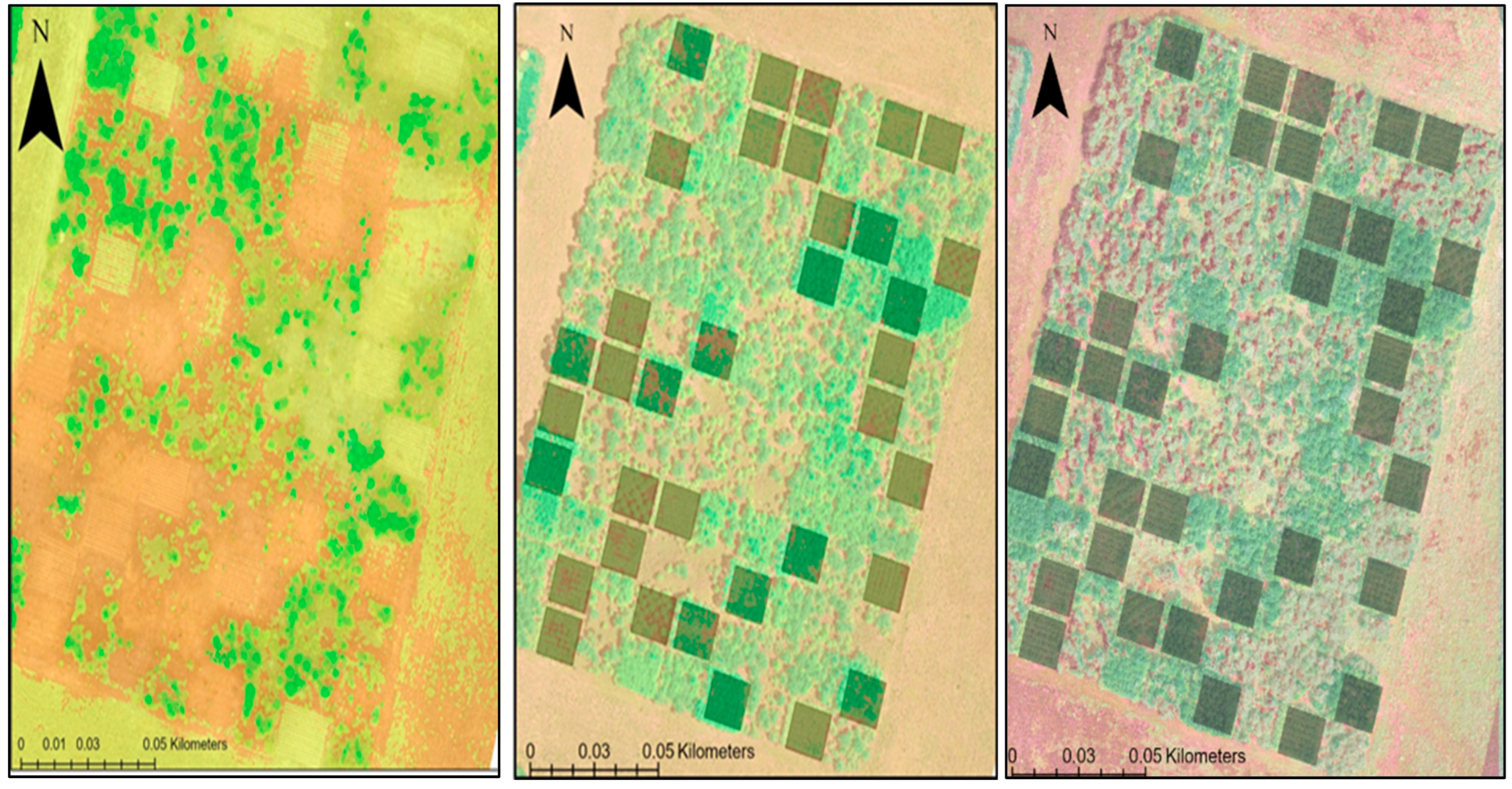
2.5. UAS Data Processing

A UAS image capture campaign was carried out on 3 March at 11:30 a.m. Eastern Standard Time (EST). The photogrammetry software (Agisoft Metashape, version 1.5.4.8885) was used to process the UAS images into 3D point clouds, orthoimages, and a digital surface model (DSM) for the survey date. The flight altitude was 68.4 m, using a ground resolution of 1.7 cm/pixel, covering an area of 0.0766 km2. One hundred and fifty-five images were produced; the average horizontal and vertical camera location error was 3.41 m and 0.46 m, respectively. The average point reprojection error was 1.94 pixels, and the spaces between the trees and other heterogeneous features were delineated in the point geometry representing the tree canopy. The density of the resulting point clouds was approximately 215 points/m2, and the resolution of the surface model was 6.82 cm/pixel. To derive the digital elevation model (DEM), ground control points (Figure 3) were situated in eight locations around the tree plots. These points were digitized into a feature class in ArcGIS Pro; the geometry of the points (x, y, and z) was calculated using the Calculate Geometry Attributes and Extract Values to Points geoprocessing tools in ArcGIS Pro. The projected points were interpolated into a ground-surface plane raster (DEM) using the v.surf.rst module in GRASS GIS 7 [51]. The plane representing the DEM was subtracted from the DSM to quantify the vegetation heights per plot, in meters, for the study area.
A 0.60 m resolution canopy height model was used to compute for each plot the mean, standard deviation, median, maximum, range, and 90th percentile to quantify the central tendency of canopy heights and the variability in canopy heights. Individual tree crowns were then identified and delineated using the “Forest Tools” package in R (R version 3.4.4 (Vienna, Austria)) [52]. From these tree-crown polygons, the mean tree-crown area (m) was calculated for each plot. Mean tree-crown height was calculated for each plot by identifying the mean canopy height (m) for each tree-crown polygon and calculating the mean for each plot. In addition, to adequately account for local spatial patterns in the canopy structure and measure the relative shape of the canopy, the canopy relief ratio (CRR) was calculated for each plot. CRR measures how close the mean height (Z_mean) is to the minimum (Z_min) and maximum (Z_max) heights for each 14 m × 14 m plot.
CRR = (Zmean − Zmin)/(Zmax − Zmin)
We derived spectral indices, the triangular greenness index (TGI), and the Visible Atmospherically Resistant Index (VARI) from the UAS imagery. TGI is based on the spectral features of chlorophyll and was used to approximate chlorophyll content and vegetation vigor from broadband visible wavelength reflectance. The band center wavelengths used were 670 nm for red, 550 nm for green, and 480 nm for blue, respectively, as proposed for broadband digital cameras by Hunt et al. [28]. TGI was summarized per plot using mean and standard deviation, where λ is the center wavelength and ρ is the pixel value of the respective bands.
TGI = {(λRed − λBlue) (ρRed − ρGreen) − (λRed − λGreen) (ρRed − ρBlue)}/2
VARI is a vegetation index for quantitatively estimating the vegetation fraction and is designed to emphasize vegetation in the visible portion of the spectrum. It is minimally sensitive to atmospheric effects, allowing vegetation to be estimated in a wide variety of environments.
VARI = (ρGreen − ρRed)/(ρGreen + ρRed − ρBlue)

2.6. Aboveground Biomass Estimation

To estimate aboveground biomass using the LiDAR data, we converted the point clouds representing vegetation heights (with the 2 m threshold applied) to DBH using the equation developed by Domec et al. [9]. With these derived DBH values, we calculated aboveground biomass for individual trees using allometric Equation (3) above. We then summed aboveground biomass measures for each plot and then converted to a per hectare estimate (Mg·ha−1).
We evaluated the relationship between UAS-derived seasonal canopy structural and spectral metrics and biomass productivity using the best-subset regression model in R, using the tidyverse, caret, and leaps packages [52]. The best-subset regression model tests all the possible combinations of predictor variables and then selects the best model according to statistical criteria [53]. We computed the variance inflation factor (VIF) to determine multicollinearity between the canopy metrics predictors. Predictor variables with a VIF greater than 9 were removed from subsequent analysis to reduce the possibility of overfitting the model. For each combination of variables, the K-fold cross-validation was used to select the highest-quality model to reduce the risk of overfitting [54].

2.7. Statistical Analysis

Analysis of variance (ANOVA) and Tukey adjustment for least square means (LSMeans) were used to examine planting-density effects on LiDAR-derived and UAS-derived AGB (aov and lm packages in R).

3. Results

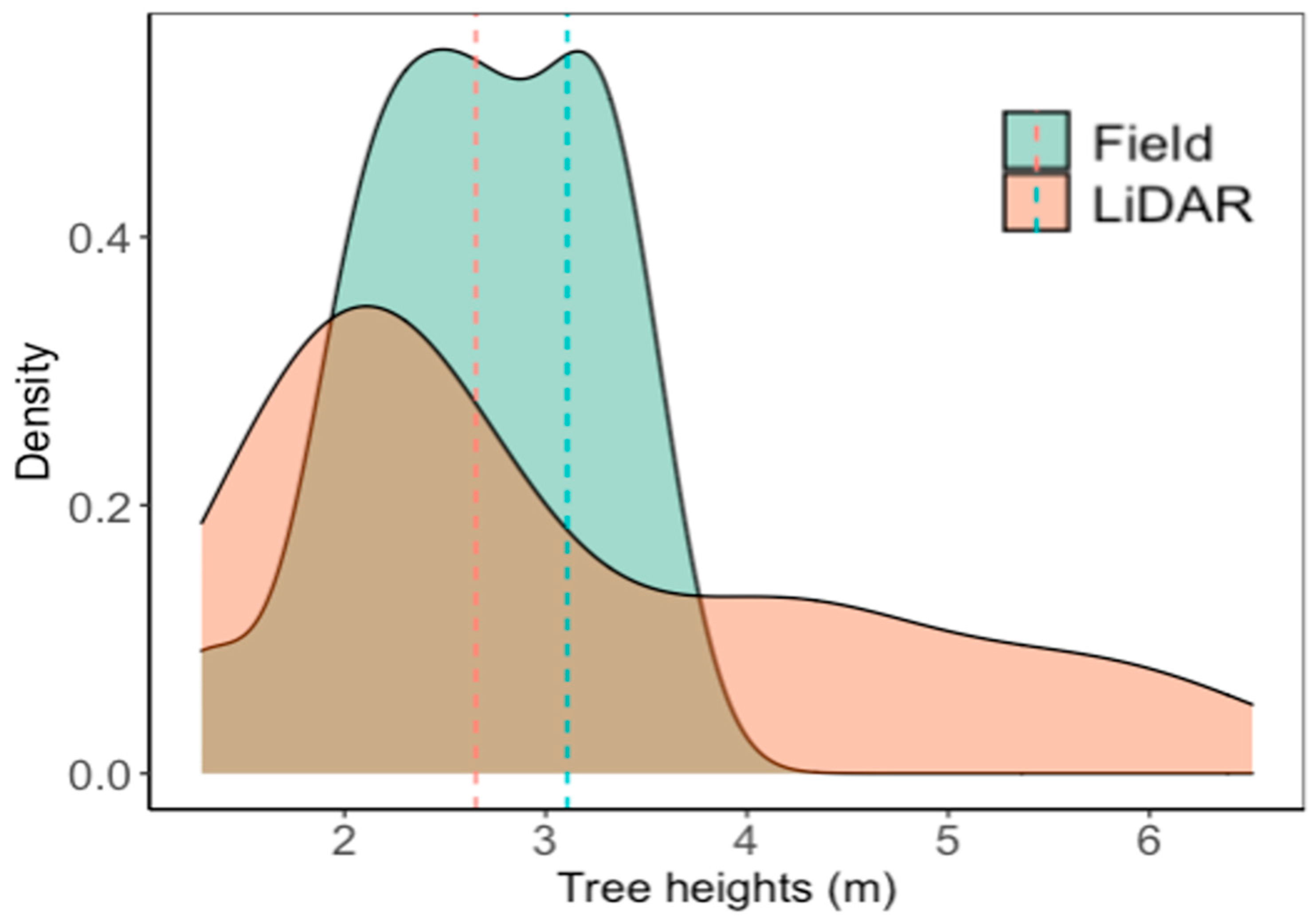
3.1. Field and LiDAR-Derived Height Measurements

We obtained a higher range of height values from the LiDAR-derived data (1.53 m–6.51 m) than our manual measurements of tree heights (48 trees, 1.94 m–3.56 m). The tree mean-and-standard-error height from the field measurements was 2.98 ± 0.48 m, while the LiDAR-derived tree mean height was 3.10 ± 1.46 m. Thus, there is more variation obtained from the LiDAR-derived tree heights compared to field-measured tree heights when averaged across the planting densities and expressed as a probability density function (Figure 4). There were no significant differences between the LiDAR results and the manually measured tree heights when averaged across the planting densities. However, when planting-density treatment was used as a factor to compare the results, there were significant differences between the LiDAR values and manual measurements in three planting densities: 1250 tph, 2500 tph, and 10,000 tph (p < 0.05).

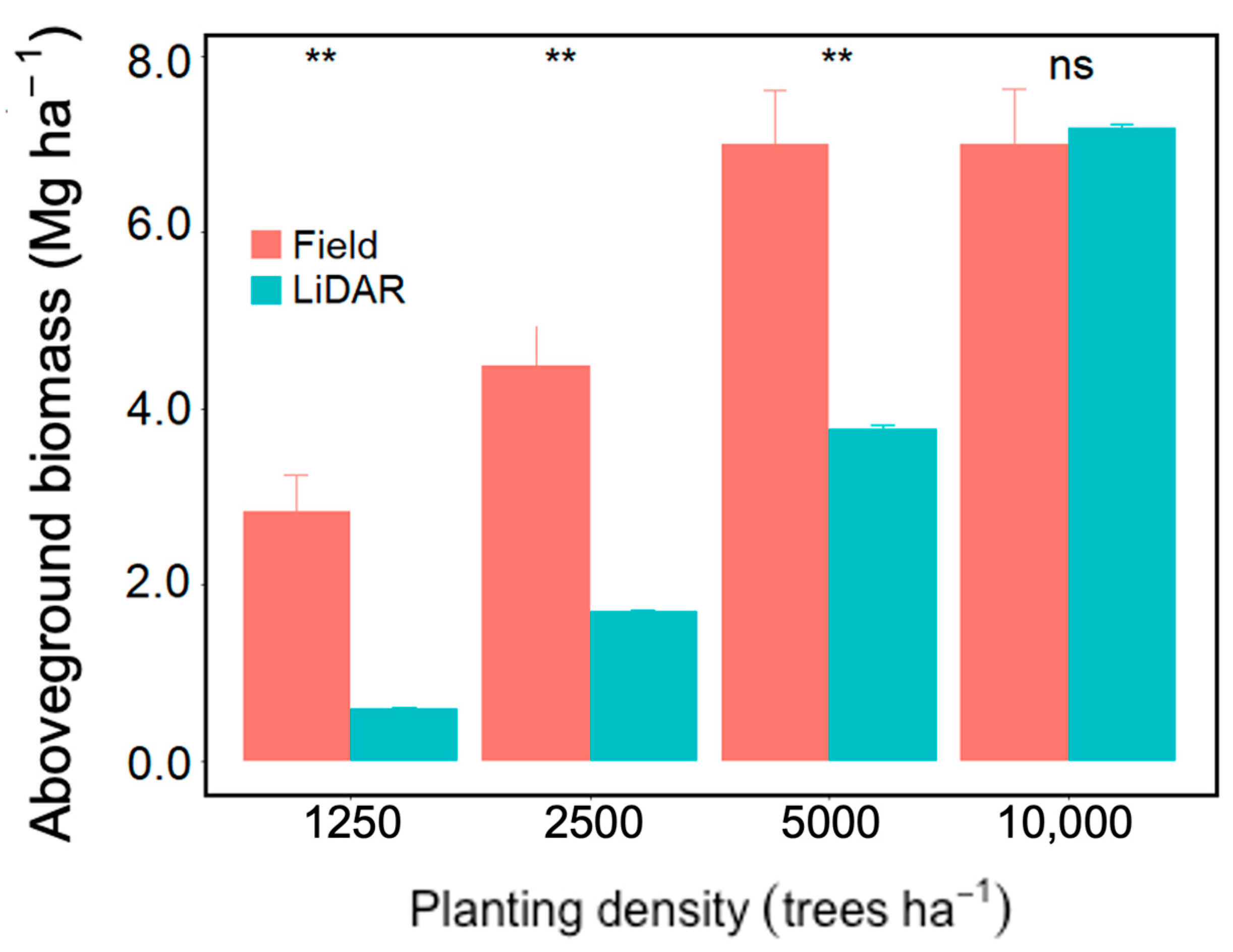
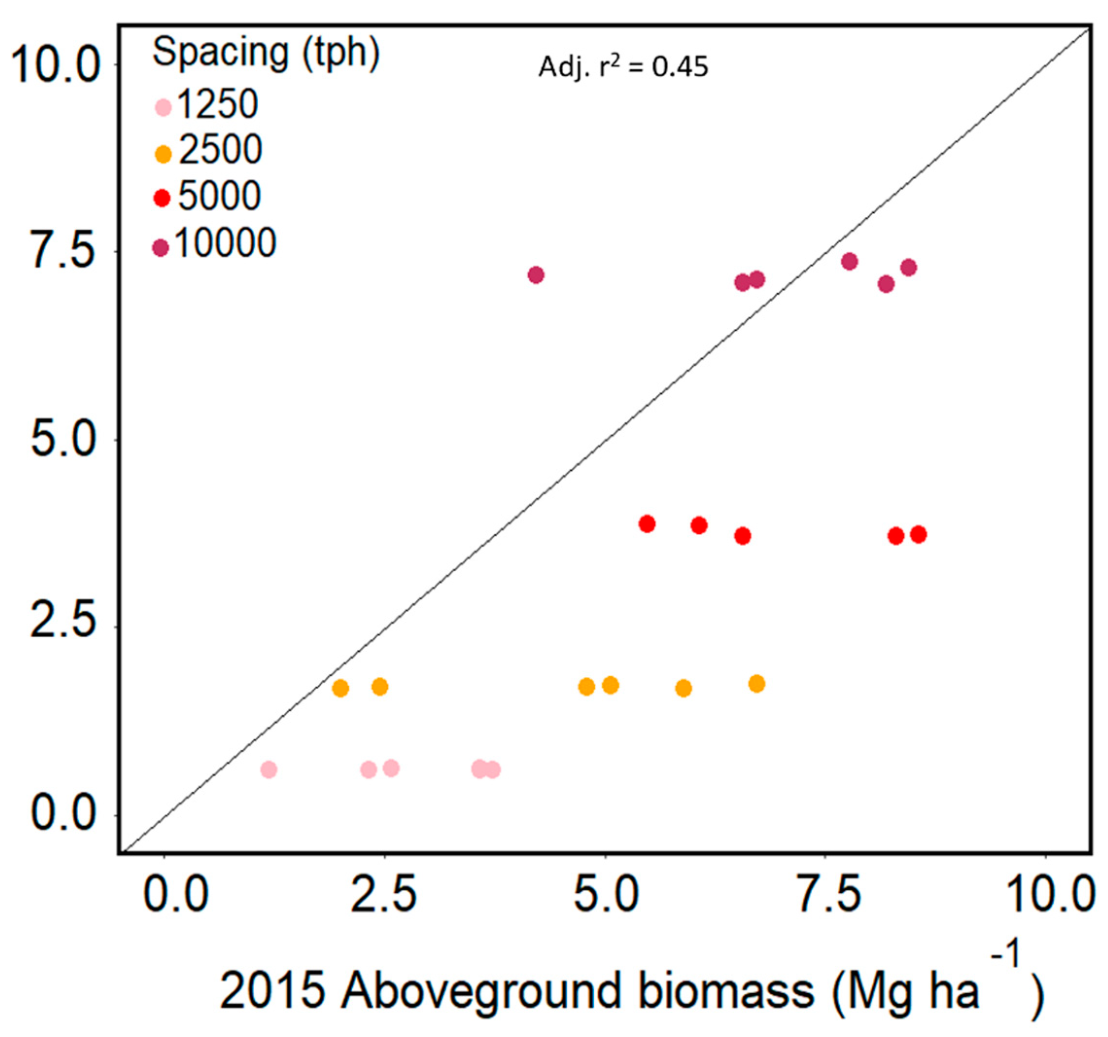
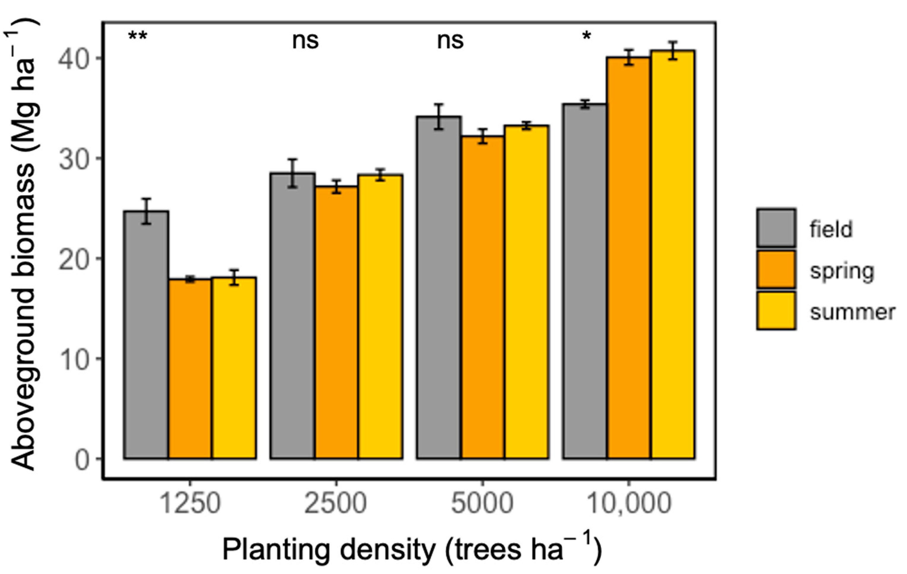
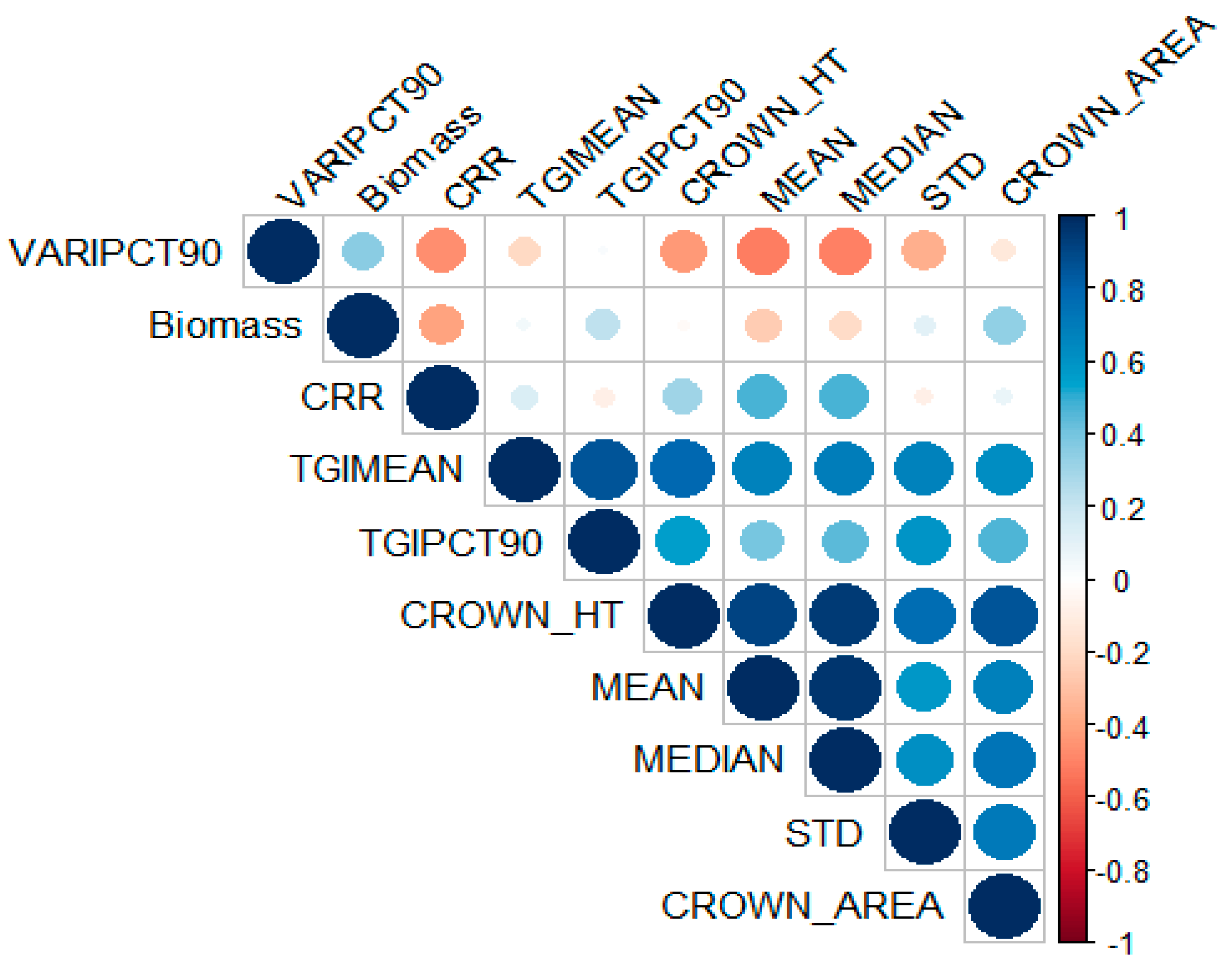
3.2. Field and LiDAR-Derived Aboveground Biomass

The LiDAR-derived AGB values were significantly lower in the 1250 tph, 2500 tph, and 5000 tph planting-density treatments compared to the 2015 field results (Figure 5). In the highest planting density, 10,000 tph, the resulting AGB estimates are within the same range for the LiDAR-derived and field-estimated measurements. There is high variation in the biomass estimates computed from the field data across all planting densities. The LiDAR biomass estimates across all plots and planting densities ranged from 0.60 ± 0.01 Mg ha−1 in 1250 tph to 7.19 ± 0.13 Mg ha−1 in the 10,000 tph, with little variation in biomass across plots within the same planting density. From the field estimates, the 10,000 tph and 5000 tph had similar aboveground biomass, which was higher than the 2500 tph and the 1250 tph treatments (Figure 4).
The LiDAR-derived AGB was regressed with a linear model fitted to the related AGB, computed from the diameter at breast heights measured in 2015. The adjusted R2 for 2015 estimates was 0.45 (Figure 6).

3.3. Field and UAS-Derived Height Measurements

The first date of the UAS flight, 3 March 2022, was within the winter season in the piedmont region of North Carolina, when the American sycamore trees were still dormant, with no leaves. Therefore, the digital surface model computed from the 3D point clouds did not capture the tree crowns of the American sycamores (although it did capture the tree crowns of the pine trees scattered around the tree plots). To verify this, we computed the canopy height model (CHM), and the results showed negative-to-zero values for the sycamore tree plots (Figure 7). CHM maps were also computed for spring and summer UAS campaigns (Figure 7). Due to the negative values from the winter CHM, canopy metrics were computed only for the spring and summer seasons.
The tree means heights derived from the UAS ranged between 3.17 m and 9.90 m across the four planting densities in spring and summer. For the planting densities, the maximum tree height processed from the UAS was 10.53 m, 12.68 m, and 14.17 m occurring in the 10,000 tph, 5000 tph, and 2500 tph treatments, respectively (Supplementary Materials Table S2). The data analyzed from the spring UAS survey showed that the 2500 tph and the 5000 tph had the highest tree mean heights of 4.87 m and 5.13 m, respectively, averaged across the tree plots in each planting density. The 10,000 tph had a mean tree height of 3.47 m, and the 1250 tph had a mean tree height of 2.93 m. From the summer UAS survey, we see that the 2500 tph had the highest average mean tree heights of 5.23 m, followed by the 5000 tph at 5.00 m. The 10,000 tph and 1250 tph had the lowest average mean heights of 3.78 m and 3.22 m, respectively.

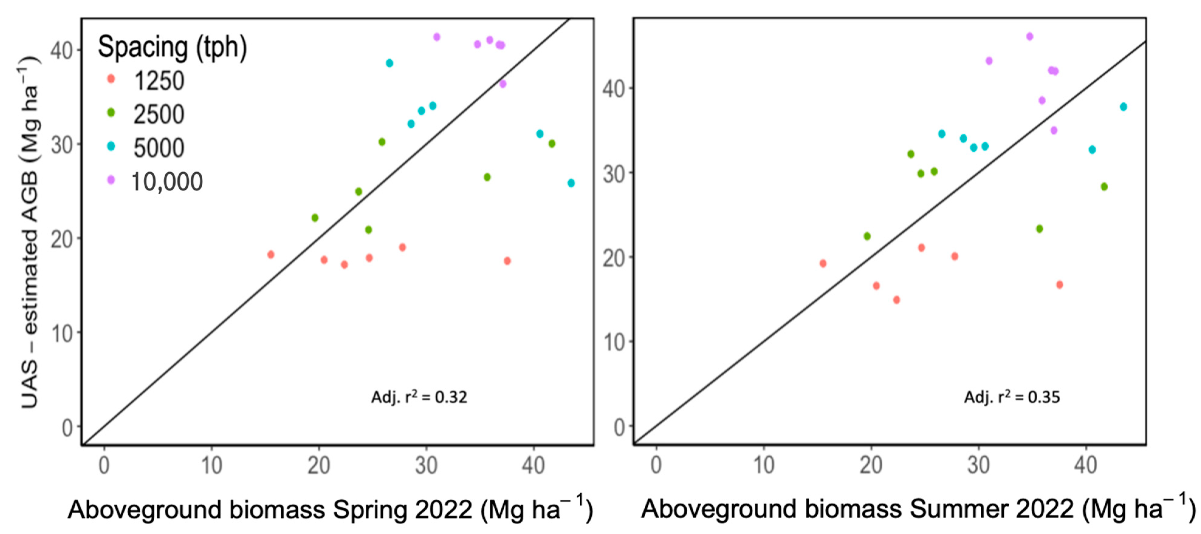
3.4. Field and UAS-Derived Aboveground Biomass

Table 1 shows a summary of the metrics computed to quantify canopy structure and spectral reflectance. Two structural metrics (tree canopy height max and tree canopy height range) and three spectral metrics (TGI median, VARI mean, and VARI median) were removed from the analysis due to collinearity. The remaining metrics were used to explain the variation in AGB. The results from the best-subset regression showed that the canopy metrics of the crown area, CRR, and TGI mean were the best predictors of AGB in spring, while the tree heights’ 90th percentile, CRR, and TGI mean were the best canopy-metric predictor of AGB in the summer.
The regression models to predict the AGB of SRC sycamore trees:
Spring:
A G B = 3.261 c r o w n   a r e a 71.540   C R R + 6.723   T G I   m e a n r 2 = 0.33 ; p < 0.05
Summer:
A G B = 5.349   90 t h   p e r c e n t i l e + 5.608   C R R + 7.1423   T G I   m e a n r 2 = 0.41 ; p < 0.05
The CRR was the most significant metric in the linear regression model to predict the AGB in spring and in summer (p < 0.01), followed by the crown area (p < 0.1). However, there was no statistical significance between the summer and spring AGB results across the four planting densities. There was a significant difference between the manually estimated AGB and UAS-derived AGB in the highest planting density, 10,000 tph, and the lowest planting density, 1250 tph (Figure 8).
In the 10,000 tph, the UAS-derived AGB of 40.08 ± 0.75 Mg ha−1 (spring) and 40.74 ± 0.87 Mg ha−1 (summer) was significantly higher than the manual estimate of 35.41 ± 0.39 Mg ha−1. However, in the 1250 tph, the UAS-derived AGB was underestimated in the spring season (17.39 ± 0.26 Mg ha−1) and summer season (18.1 ± 0.75 Mg ha−1) compared to the manual estimate of (24.71 ± 1.25 Mg ha−1) (Figure 8). For the 2500 tph and the 5000 tph, there was no significant difference between field and UAS-derived AGB estimates (Figure 8). The standard error was higher for the mean AGB from field estimates than UAV-derived estimates for all planting densities except (10,000 tph) (Figure 8). The UAS-derived AGB was regressed with a linear model fitted to the manually estimated AGB computed from the diameter at breast heights measured in 2022. The adjusted R2 estimate for Spring 2022 was 0.32, and for Summer 2022, it was 0.35 (Figure 9).

4. Discussion

4.1. Low-Density LiDAR for American Sycamore SRC Plantations

The goal of this study was to test the efficacy of combining publicly available and/or inexpensive remote-sensing technologies, collected from different time periods and with different specifications, to quantify changes in the aboveground biomass and carbon storage of American sycamore SRC over time. We compared our remote sensing-derived approach to the conventional allometric methods that rely on manual measurements of diameters and heights on large numbers of trees. With the rapid advances in remote-sensing technologies over the last decade, we need to understand the ability to leverage, at times, disparate datasets for environmental inventory and monitoring. Here, we use common approaches for estimating aboveground biomass.
Our results suggest that LiDAR data can be used to estimate the tree height and standing biomass of coppiced sycamore trees, but that accuracy increases with increasing stand density. Although the tree-height values derived from LiDAR were lower than the field estimates in the three lower planting densities (1250 tph, 2500 tph, and 5000 tph), when averaged across planting density treatments, the difference was not statistically significant (Figure 4). However, there were significant differences between three of the planting densities, with l250 tph having the lowest mean tree heights estimated from the LiDAR, compared to the 2500 tph and 5000 tph. The tree heights and height-to-crown ratio vary with increasing competition intensity [55,56]. Similar results were found in Siberian elm trees, where an increase in planting density from 1400 tph to 7000 tph significantly affected average tree heights [57,58]. Smaller standard deviations of the AGB means across all plots for each planting density were found to be associated with LiDAR-derived AGB estimates. Xu et al. [59] also found negligible errors associated with LiDAR-derived estimates as the sample size increased, attributed to the calibration of their height-based allometric equations using manual measurements.
The evaluation of the 1:1 line for the predicted LiDAR-derived AGB and the observed manually estimated AGB showed similar significance, with a R2 of 0.45 (p < 0.001) (Figure 5). This indicates a reasonably strong relationship between LiDAR estimates and the manual estimates. In a study of pine plantations in the North of Spain, the authors found that low density (0.5 pulse/m2) could predict aboveground biomass (r2 = 0.80) with two variables of interest, tree height and canopy density [60]. Similar accuracies were found in other studies of pine forests [61,62]. These accuracies are higher than the accuracies we achieved. Part of this could be due to the short stature of the vegetation during the LiDAR flights. Reigel et al. (2013) [48] found that, in areas comprising young evergreen and deciduous trees, optical imagery models explained more of the variation in aboveground carbon than discrete-return low-density LiDAR models (adj-R2 = 0.34 and adj-R2 = 0.18, respectively. However, our results suggested an improvement in the ability to map aboveground biomass at higher planting densities. This is evident in higher AGB in the 10,000 tph compared to the other planting densities derived from LiDAR and the field measurements. The close estimates of the LiDAR-derived and field-estimated AGB in the 10,000 tph treatment, 7.2 Mg ha−1 and 7.0 Mg ha−1, respectively, suggest that the low-density LiDAR data can accurately estimate the AGB of American sycamore SRC in higher planting densities [63].

4.2. Consumer-Grade UAS Cameras for American Sycamore SRC Plantations

Another part of this study was to determine if we could predict AGB from photogrammetric canopy-height models. We evaluated the usefulness of structural metrics and spectral metrics in describing canopy shape and uniformity for improving the management of SRCs. Researchers have found that the combination of structural and spectral features to predict canopy height may prove more effective in estimating in AGB [64,65,66]. We found that the mean tree heights derived from the UAS-CHM (10.53 m to 14.47 m) were close in range compared to the manually measured tree heights in 2022 (8.20 m to 14.82 m). Generally, remotely sensed tree-height data are more accurate than the tree canopy area due to the overlapping of adjacent tree canopies, tree species, and methods used for individual tree identification [14,67,68,69,70,71].
Furthermore, our findings reveal that the AGB of American sycamore SRC can be modeled at a high spatial resolution using measures of central tendency or deviation, in combination with CHM-based structural and spectral metrics derived from UAS imagery. Studies have explored methods for remotely assessing canopy metrics that are closely correlated to AGB, yield, and productivity. For example, Li et al. [45] found that CRR had a high correlation with leaf area development. That is consistent with our study, which found that CRR, crown area, TGI mean, and tree heights’ 90th percentile were the most important predictors of AGB. Furthermore, a correlation matrix showed a moderately to strongly negative correlation between AGB (biomass), TGI, and CRR (Figure 10). On the other hand, a strong positive correlation was observed between AGB and VARI (Figure 10).
The planting density treatment had significant effects on UAS-derived AGB and the 2022 manually estimated AGB from the field. This was most evident in the 10,000 tph, where UAS-derived AGB was significantly overestimated compared to the manual estimates. In contrast, at the lowest planting density, the UAS-derived AGB was significantly underestimated compared to the field estimates (Figure 8). In this case, the narrower tree spacing in the high planting density may have resulted in more hits on the higher canopy structure, while in the wider spacing, the UAS may capture lower branches and ground structures that lead to underestimation. Another study using UAS-CHM metrics reported that the biomass of small statured vegetation was similarly over- and underestimated; smaller-diameter shrubs were overestimated, and larger-diameter shrubs were underestimated [66]. In contrast, the forest canopy heights and aboveground carbon of trees in a rainforest (with close canopy gaps) were systematically underestimated using the SfM [72].
These phenomena and uncertainty are common with estimates from UAS-CHM compared to terrestrial laser scanning, due to the difficulty of accurately detailing terrain beneath dense vegetation, such as in bioenergy plantations [73,74,75,76]. Aside from the planting density treatment, the interpolation, spatial resolution, and smoothing of the CHM may present several errors that could affect individual tree-canopy segmentation in various forest types [77,78]. Ciesielski and Sterenczak [79] explained that single algorithms and single point clouds might result in under- and overestimation due to the variation in shape and size of tree canopy, light conditions, and human activities modifying the tree shapes. However, in the 2500 tph and 5000 tph treatments of the current study, the UAS-derived AGB values were close to the manually estimated AGB values (Figure 8). This shows that the canopy metrics could be used to model the AGB of American sycamore SRC, depending on planting density. The linear relationship between the manually estimated AGB in 2022 and the predicted UAS-derived AGB for spring and summer had an adj-R2 of 0.32 and 0.35 (p < 0.05), respectively. In addition, the combination of UAS structural and spectral metrics explained only 33% and 41% of the variation in the predicted AGB for the spring and summer seasons, respectively. It is possible that model performance can be improved by making critical decisions during the computation of metrics and during image acquisition and processing, like camera angle, image overlap, flight time of day, altitude, point filtering, and surface interpolation [32]. For example, tree plots with dense canopies may lack features with high contrast, like bare earth. This could improve the UAS Structure-from-Motion process, decreasing point cloud errors and improving the model performance [32].
Another objective of this study was to assess the seasonal canopy structure development of coppiced American sycamore trees grown at high density for bioenergy. We could not retrieve any data from the first UAS-flight campaign in the winter since trees had no foliage during this period. However, the georeferenced DSM derived from the winter flight can be used as a DEM in calculating subsequent CHM for the specific site. Maximum canopy structure development was confirmed at the end of the growing season of poplar trees in a coppice management study [80] and likewise with other SRC studies [81,82,83]. Additionally, the leaf area development of the SRC poplar trees increased rapidly in the first three years after coppicing and began to decline after the third year. This phenomenon is what we have observed over twelve years in three rotation cycles of American sycamore trees, where the biomass productivity of the trees starts to decline after the third year [8,9]. In contrast to these results, and our premise that canopy structure will be markedly different during the summer when leaf area development would be at its maximum, there was no significant difference between the results from the spring campaign and the summer campaign. This suggests that the sycamore trees may have reached close to full leaf-area development by the time of our spring measurement campaign on 4 June 2022, with little additional leaf area added after that time.

4.3. Limitations and Future Research

To our knowledge, this is the first study that examined the use of low-density LiDAR data and UAS photogrammetric point clouds to estimate the AGB of American sycamore SRC purposely grown as a bioenergy feedstock. Our findings demonstrate that information about tree canopy height and canopy structure variation, as affected by planting density, can be used to model the productivity of American sycamore SRC and provide useful information for management. The workflow developed in our study provides a way to estimate the AGB of fast-growing hardwood trees managed in a coppiced system at a broader spatial scale than ground-based measurements, with easily accessible remote-sensing technologies (low-point density LiDAR and UAS-consumer grade RGB cameras).
A limitation of using publicly available LiDAR data, like those used in this study, is that the flight parameters have been predetermined and potentially optimized for a specific-use case (for the NC Floodplain Mapping Program, this was to provide statewide digital elevation models and resulted in flights during leaf-off conditions and at relatively low pulse density). These flight parameters may be less than optimal for deriving heights of small stature trees (which comprised a significant proportion of our plots) or detecting top branches and the highest points of trees, thereby underestimating the maximum tree height in lower planting densities [19,84]. An individual tree-crown approach with higher-resolution LiDAR point clouds can be considered as a potential future research direction. Furthermore, variation in heights derived from LiDAR may be due to divergent laser pulses and the failure of laser pulses to hit the terminal leaders, especially in hardwood trees, compared to the compact and cone-shaped form of conifers [85]. In our study, the strength of the relationship between tree canopy metrics and predicted AGB were relatively low compared to other studies using conifers and non-coppiced hardwood trees, but the consistency of the relationships points to areas of possible model improvement. While a high-precision GPS could improve the accuracy of tree-height estimates and the model’s ability to predict AGB [86,87], it is not necessary for estimating average and total AGB, especially if tracking changes over time is not required [72,88]. Each plot has biomass estimates for at least 25 trees and in the lowest planting density (1250 tph) and 196 aboveground biomass estimates from trees in the highest planting density (10,000 tph); therefore, we can assume that these results are robust enough to encourage further testing and point to the potential to utilize UAV and publicly available LiDAR data to fill gaps in monitoring for American sycamore plantations. Future studies could build on these results, with additional field data capturing the potential variability in these systems.
Errors may also have been introduced when setting a threshold of “small” trees to be removed in the point clouds to avoid the effects of grasses and shrubs in the analysis. Furthermore, researchers have attributed potential problems to using consumer-grade cameras to calculate canopy spectral metrics like TGI, where digital numbers are based on camera exposure rather than spectral reflectance, calling for a closer examination of radiometric calibration of digital cameras [33]. Hence, a continuous multitemporal monitoring of the sycamore SRC plots could highlight patterns in LiDAR and UAS performance, as well as stand characteristics. The long record of our manually derived allometric equations and annual plot inventory data allowed us to derive accurate AGB reference estimates, providing the opportunity to test the efficacy of the remote-sensing methods [5,6,9].

5. Conclusions

With the availability of timely and suitable remote-sensing data, accurate inventories can be carried out at a fraction of the cost compared to manual field inventories and destructive sampling [89]. This will greatly benefit the planning and management of short-rotation woody crops, especially for farmers new to the forest practices, monitoring, and managing of SRC productivity, as well as planning harvests [61]. Furthermore, our approach could be used in other SRC plantations, with careful consideration to the relationships between canopy gaps, canopy structure, canopy heights, and planting density which may affect the accuracy of the approximations [72,90], especially for other forest types such as lowland forests or uneven age stands. Thus, our findings may contribute to the common goal of a climate-smart approach, using nature-based solutions to improve ecosystem models and increasing tree-crop productivity with remote monitoring and advanced technologies, thereby encouraging farmers to engage in food–energy production. To this end, the importance of evaluating how the SRC canopy structure affects ecosystem model performance to predict aboveground biomass and develop mitigation strategies for climate change, while estimating global forest carbon storage, cannot be overemphasized.

Supplementary Materials

The following supporting information can be downloaded at: https://www.mdpi.com/article/10.3390/rs16142589/s1.

Author Contributions

Conceptualization, O.J.U. and J.S.K.; Methodology, O.J.U. and L.S.; Formal Analysis, O.J.U., L.S. and J.J.; Investigation, O.J.U. and L.S; Data Curation, O.J.U., L.S. and J.J.; Writing—Original Draft Preparation, O.J.U.; Writing—Review and Editing, O.J.U., L.S., H.M. and J.S.K.; Visualization, O.J.U. and L.S.; Supervision, H.M. and J.S.K.; Project Administration, O.J.U. and J.S.K. All authors have read and agreed to the published version of the manuscript.

Funding

Funding for this project was provided by USDA CSREES Rural Development Program 2009-10001-05311, USDA NIFA 2010-34458-21103, and the North Carolina Department of Agriculture and Consumer Services/North Carolina Bioenergy Research Initiative award 17-072-4028. Significant in-kind and logistical support was provided by the NCDACS Oxford Tobacco Research Station, which made the project possible.

Data Availability Statement

The original contributions presented in the study are included in the article and Supplementary Materials, further inquiries can be directed to the corresponding author.

Conflicts of Interest

The authors declare no conflict of interest.

References

  1. Edenhofer, O.; Pichs-Madruga, R.; Sokona, Y.; Seyboth, K.; IPCC (Intergovernmental Panel on Climate Change) (Eds.) Climate Chang. 2012: Special Report on Renewable Energy Sources and Climate Change Mitigation; Cambridge University Press: Cambridge, UK, 2012. [Google Scholar]
  2. Castaño-Díaz, M.; Álvarez-Álvarez, P.; Tobin, B. Nieuwenhuis, M.; Afif-Khouri, E.; Cámara-Obregón, A. Evaluation of the use of low-density LiDAR data to estimate structural attributes and biomass yield in a short-rotation willow coppice: An example in a field trial. Ann. For. Sci. 2017, 74, 69. [Google Scholar] [CrossRef]
  3. Popp, J.; Lakner, Z.; Harangi-Rakos, M.; Fari, M. The effect of bioenergy expansion: Food, energy, and environment. Renew. Sustain. Energy Rev. 2014, 32, 559–578. [Google Scholar] [CrossRef]
  4. Scarlat, N.; Dallemand, J.F. Recent developments of biofuels/bioenergy sustainability certification: A global overview. Energy Policy 2011, 39, 1630–1646. [Google Scholar] [CrossRef]
  5. Ile, O.J.; Aguilos, M.; Morkoc, S.; Heitman, J.; King, J.S. Root Biomass Distribution and Soil Physical Properties of Short-Rotation Coppice American Sycamore (Platanus occidentalis L.) Grown at Different Planting Densities. Forests 2021, 12, 1806. [Google Scholar] [CrossRef]
  6. Rosso, L.; Facciotto, G.; Bergante, S.; Vietto, L.; Nervo, G. Selection and testing of Populus alba and Salix spp. as bioenergy feedstock: Preliminary results. Appl. Energy 2013, 102, 87–92. [Google Scholar] [CrossRef]
  7. Broeckx, L.S.; Verlinden, M.S.; Ceulemans, R. Establishment and two-year growth of a bio-energy plantation with fast-growing Populus trees in Flanders (Belgium): Effects of genotype and former land use. Biomass Bioenergy 2012, 42, 151–163. [Google Scholar] [CrossRef]
  8. Ile, O.J.; Aguilos, M.; Morkoc, S.; Minick, K.; Domec, J.-C.; King, J.S. Productivity of low-input short-rotation coppice American sycamore (Platanus occidentalis L.) grown at different planting densities as a bioenergy feedstock over two rotation cycles. Biomass Bioenergy 2021, 146, 105983. [Google Scholar] [CrossRef]
  9. Domec, J.C.; Ashley, E.; Fischer, M.; Noormet, A.; Boone, J.; Williamson, J.C.; King, J.S. Productivity, biomass partitioning, and energy yield of low-input short-rotation American Sycamore (Platanus occidentalis L.) grown on marginal land: Effects of planting density and simulated drought. Bioenergy Res. 2017, 10, 903–914. [Google Scholar] [CrossRef]
  10. Chan, E.P.Y.; Fung, T.; Wong, F.K.K. Estimating aboveground biomass of subtropical forest using airborne LiDAR in Hong Kong. Sci. Rep. 2021, 11, 1751. [Google Scholar] [CrossRef]
  11. Issa, S.; Dahy, B.; Ksiksi, T.; Saleous, N. A review of terrestrial carbon assessment methods using geo-spatial technologies with emphasis on arid lands. Remote Sens. 2020, 12, 2008. [Google Scholar] [CrossRef]
  12. Kumar, L.; Sinha, P.; Taylor, S.; Alqurashi, A.F. Review of the use of remote sensing for biomass estimation to support renewable energy generation. J. Appl. Remote Sens. 2015, 9, 097696. [Google Scholar] [CrossRef]
  13. Arney, J.D.; Corrao, M.V. The Evolution of Forest Inventory (a Comparison of Satellite, Lidar, and Traditional Forest Inventory Methods); Forest Biometrics Institute: Portland, OR, USA, 2021. [Google Scholar]
  14. Popescu, S.C.; Wynne, R.H.; Nelson, R.F. Measuring individual tree crown diameter with LiDAR and assessing its influence on estimating forest volume and biomass. Can. J. Remote Sens. 2003, 29, 564–577. [Google Scholar] [CrossRef]
  15. Lu, D.; Chen, Q.; Wang, G.; Moran, E.; Batistella, M.; Zhang, M.; Laurin, G.V.; Saah, D. Aboveground Forest biomass estimation with Landsat and lidar data and uncertainty analysis of the estimates. Int. J. For. Res. 2012, 2012, 436537. [Google Scholar] [CrossRef]
  16. Xu, D.; Wang, H.; Xu, W.; Luan, Z.; Xu, X. LiDAR Applications to Estimate Forest Biomass at Individual Tree Scale: Opportunities, Challenges and Future Perspectives. Forests 2021, 12, 550. [Google Scholar] [CrossRef]
  17. Lefsky, M.A.; Cohen, W.B.; Acker, A.S.; Parker, G.G.; Spies, T.A.; Harding, D. Lidar Remote Sensing of the Canopy Structure and Biophysical Properties of Douglas-Fir Western Hemlock Forests. Remote Sens. Environ. 1999, 70, 339–361. [Google Scholar] [CrossRef]
  18. Zolkos, S.G.; Goetz, S.J.; Dubayah, R. A meta-analysis of terrestrial aboveground biomass estimation using lidar remote sensing. Remote Sens. Environ. 2013, 128, 289–298. [Google Scholar] [CrossRef]
  19. Andújar, D.; Escolà, A.; Rosell-Polo, J.; Sanz, R.; Rueda-Ayala, V.; Fernández-Quintanilla, C.; Dorado, J. A LiDAR-based system to assess poplar biomass. Gesunde Pflanz. 2016, 68, 155–162. [Google Scholar] [CrossRef]
  20. Domingo, D.; Ørka, H.O.; Næsset, E.; Kachamba, D.; Gobakken, T. Effects of UAV Image Resolution, Camera Type, and Image Overlap on Accuracy of Biomass Predictions in a Tropical Woodland. Remote Sens. 2019, 11, 948. [Google Scholar] [CrossRef]
  21. Puliti, S.; Olerka, H.; Gobakken, T.; Næsset, E. Inventory of Small Forest Areas Using an Unmanned Aerial System. Remote Sens. 2015, 7, 9632–9654. [Google Scholar] [CrossRef]
  22. Wallace, L.; Lucieer, A.; Malenovský, Z.; Turner, D.; Vopěnka, P. Assessment of Forest Structure Using Two UAV Techniques: A Comparison of Airborne Laser Scanning and Structure from Motion (SfM) Point Clouds. Forests 2016, 7, 62. [Google Scholar] [CrossRef]
  23. Tuominen, S.; Balazs, A.; Saari, H.; Pölönen, I.; Sarkeala, J.; Viitala, R. Unmanned aerial system imagery and photogrammetric canopy height data in area-based estimation of forest variables. Silva Fenn. 2015, 49, 1348. [Google Scholar] [CrossRef]
  24. Lisein, J.; Pierrot-Deseilligny, M.; Bonnet, S.; Lejeune, P. A Photogrammetric Workflow for the Creation of a Forest Canopy Height Model from Small Unmanned Aerial System Imagery. Forests 2013, 4, 922–944. [Google Scholar] [CrossRef]
  25. Zhang, C.; Kovacs, J. The application of small-unmanned aerial systems for precision agriculture: A review. Precis. Agric. 2012, 13, 693–712. [Google Scholar] [CrossRef]
  26. Corti, M.; Cavalli, D.; Cabassi, G.; Vigoni, A.; Degano, L.; Marino Gallina, P. Application of a low-cost camera on a UAV to estimate maize nitrogen-related variables. Precis. Agric. 2019, 20, 675–696. [Google Scholar] [CrossRef]
  27. Dalla Corte, A.P.; Rex, F.E.; Almeida, D.R.A.d.; Sanquetta, C.R.; Silva, C.A.; Moura, M.M.; Wilkinson, B.; Zambrano, A.M.A.; Cunha Neto, E.M.d.; Veras, H.F.P.; et al. Measuring Individual Tree Diameter and Height Using GatorEye High-Density UAV-Lidar in an Integrated Crop-Livestock-Forest System. Remote Sens. 2020, 12, 863. [Google Scholar] [CrossRef]
  28. Lim, K.S.; Treitz, P.M. Estimation of above ground forest biomass from airborne discrete return laser scanner data using canopy-based quantile estimators. Scand. J. For. Res. 2004, 19, 558–570. [Google Scholar] [CrossRef]
  29. Patenaude, G.; Hill, R.A.; Milne, R.; Gaveau, D.L.A.; Briggs, B.B.J.; Dawson, T.P. Quantifying Forest above ground carbon content using LiDAR remote sensing. Remote Sens. Environ. 2004, 93, 368–380. [Google Scholar] [CrossRef]
  30. Parker, G.G.; Russ, M.E. The canopy surface and stand development: Assessing Forest canopy structure and complexity with near-surface altimetry. For. Ecol. Manag. 2004, 189, 307–315. [Google Scholar] [CrossRef]
  31. Li, W.; Niu, Z.; Chen, H.; Li, D. Characterizing canopy structural complexity for the estimation of maize LAI based on ALS data and UAV stereo images. Int. J. Remote Sens. 2017, 38, 2106–2116. [Google Scholar] [CrossRef]
  32. Montgomery, K.; Henry, J.B.; Vann, M.C.; Whipker, B.E.; Huseth, A.S.; Mitasova, H. Measures of Canopy Structure from Low-Cost UAS for Monitoring Crop Nutrient Status. Drones 2020, 4, 36. [Google Scholar] [CrossRef]
  33. Hunt, E.R.; Doraiswamy, P.C.; McMurtrey, J.E.; Daughtry, C.S.T.; Perry, E.M.; Akhmedov, B. A visible band index for remote sensing leaf chlorophyll content at the canopy scale. Int. J. Appl. Earth Obs. Geoinf. 2013, 21, 103–112. [Google Scholar] [CrossRef]
  34. Hatfield, J.L.; Prueger, J.H. Value of using different vegetation indices to quantify agricultural crop characteristics at different growth stages under varying management practices. Remote Sens. 2010, 2, 562–578. [Google Scholar] [CrossRef]
  35. Hunt, E.R.; Daughtry, C.S.T.; Eitel, J.U.H.; Long, D.S. Remote sensing leaf chlorophyll content using a visible band index. Agron. J. 2011, 103, 1090–1099. [Google Scholar] [CrossRef]
  36. Carrivick, J.; Smith, M.; Quincey, D. Structure from Motion in the Geosciences, 1st ed.; Number Book, Whole in New Analytical Methods in Earth and Environmental Science; Wiley-Blackwell: Hoboken, NJ, USA, 2016. [Google Scholar]
  37. St-Onge, B.; Vega, C.; Fournier, R.A.; Hu, Y. Mapping canopy height using a combination of digital stereo-photogrammetry and lidar. Int. J. Remote Sens. 2008, 29, 3343–3364. [Google Scholar] [CrossRef]
  38. Guerra-Hernández, J.; González-Ferreiro, E.; Monleón, V.J.; Faias, S.P.; Tomé, M.; Díaz-Varela, R.A. Use of Multi-Temporal UAV-Derived Imagery for Estimating Individual Tree Growth in Pinus pinea Stands. Forests 2017, 8, 300. [Google Scholar] [CrossRef]
  39. Gobakken, T.; Bollandsås, O.M.; Næsset, E. Comparing biophysical forest characteristics estimated from photogrammetric matching of aerial images and airborne laser scanning data. Scand. J. For. Res. 2014, 30, 73–86. [Google Scholar] [CrossRef]
  40. Järnstedt, J.; Pekkarinen, A.; Tuominen, S.; Ginzler, C.; Holopainen, M.; Viitala, R. Forest variable estimation using a high-resolution digital surface model. J. Photogramm. Remote Sens. 2012, 74, 78–84. [Google Scholar] [CrossRef]
  41. Wallace, L.; Lucieer, A.; Watson, C.S. Evaluating Tree Detection and Segmentation Routines on Very High-Resolution UAV LiDAR Data. IEEE Trans. Geosci. Remote Sens. 2014, 52, 7619–7628. [Google Scholar] [CrossRef]
  42. Chianucci, F.; Disperati, L.; Guzzi, D.; Bianchini, D.; Nardino, V.; Lastri, C.; Rindinella, A.; Corona, P. Estimation of canopy attributes in beech forests using true colour digital images from a small fixed-wing UAV. Int. J. Appl. Earth Obs. Geoinf. 2016, 47, 60–68. [Google Scholar] [CrossRef]
  43. Fraser, B.; Congalton, R.; Fraser, B.T.; Congalton, R.G. Issues in Unmanned Aerial Systems (UAS) Data Collection of Complex Forest Environments. Remote Sens. 2018, 10, 908. [Google Scholar] [CrossRef]
  44. Hayashi, R.; Weiskittel, A.; Sader, S. Assessing the feasibility of low-density LiDAR for stand inventory attribute predictions in complex and managed forests of northern Maine, USA. Forests 2014, 5, 363–383. [Google Scholar] [CrossRef]
  45. Woods, M.; Pitt, D.; Penner, M.; Lim, K.; Nesbitt, D.; Etheridge, D.; Treitz, P. Operational implementation of a LiDAR inventory in Boreal Ontario. For. Chron. 2011, 87, 512–528. [Google Scholar] [CrossRef]
  46. Smart, L.S.; Swenson, J.J.; Christensen, N.L.; Sexton, J.O. Three-dimensional characterization of pine forest type and red-cockaded woodpecker habitat by small-footprint, discrete-return lidar. For. Ecol. Manag. 2012, 281, 100–110. [Google Scholar] [CrossRef]
  47. Smart, L.S.; Taillie, P.J.; Poulter, B.; Vukomanovic, J.; Singh, K.K.; Swenson, J.J.; Mitasova, H.; Smith, J.W.; Meentemeyer, R.K. Aboveground carbon loss associated with the spread of ghost forests as sea levels rise. Environ. Res. Lett. 2020, 15, 104028. [Google Scholar] [CrossRef]
  48. Riegel, J.B.; Bernhardt, E.; Swenson, J. Estimating above-ground carbon biomass in a newly restored coastal plain wetland using remote sensing. PLoS ONE 2013, 8, e68251. [Google Scholar] [CrossRef] [PubMed]
  49. National Center for Environmnetal Information; National Oceanic and Atmospheric Administrartion. Available online: https://coast.noaa.gov/digitalcoast/data/ (accessed on 15 January 2022).
  50. GRASS Development Team. Geographic Resources Analysis Support System (GRASS) Software, Version 7.8; Open Source Geospatial Foundation: Chicago, IL, USA, 2020; Available online: https://grass.osgeo.org (accessed on 8 July 2024).
  51. Mitasova, H.; Mitas, L.; Harmon, R.S. Simultaneous spline interpolation and topographic analysis for lidar elevation data: Methods for Open-source GIS. IEEE Geosci. Remote Sens. Lett. 2005, 2, 375–379. [Google Scholar] [CrossRef]
  52. R Core Team. R: A Language and Environment for Statistical Computing; R Foundation for Statistical Computing: Vienna, Austria, 2021. [Google Scholar]
  53. Wada, Y.; Wisser, D.; Eisner, S.; Flörke, M.; Gerten, D.; Haddeland, I.; Hanasaki, N.; Masaki, Y.; Portmann, F.T.; Stacke, T.; et al. Multimodel projections and uncertainties of irrigation water demand under climate change. Geophys. Res. Lett. 2013, 40, 4626–4632. [Google Scholar] [CrossRef]
  54. Breiman, L. Random Forests. Mach. Learn. 2001, 45, 5–32. [Google Scholar] [CrossRef]
  55. Xioa, S.; Chen, S.Y.; Zhao, L.Q.; Wang, G. Density Effects on Plant Height Growth and Inequality in Sunflower Populations. J. Integr. Plant Biol. 2006, 48, 5. [Google Scholar] [CrossRef]
  56. Berbeć, A.K.; Matyka, M. Planting Density Effects on Grow Rate, Biometric Parameters, and Biomass Calorific Value of Selected Trees Cultivated as SRC. Agriculture 2020, 10, 583. [Google Scholar] [CrossRef]
  57. Geyer, W.A.; Argent, R.M.; Walawender, W.P. Biomass properties and gasification behavior of 7-year-old Siberian elm. Wood Fiber Sci. 1987, 19, 176–182. [Google Scholar]
  58. Perez, I.; Perez, J.; Carrasco, J.; Ciria, P. Siberian elm responses to different culture conditions under short rotation forestry in Mediterranean areas. Turk. J. Agric. For. 2014, 38, 652–662. [Google Scholar] [CrossRef]
  59. Xu, Q.; Man, A.; Fredrickson, M.; Hou, Z.; Pitkänen, J.; Wing, B.; Ramirez, C.; Li, B.; Greenberg, J.A. Quantification of uncertainty in aboveground biomass estimates derived from small-footprint airborne LiDAR. Remote Sens. Environ. 2018, 216, 514–528. [Google Scholar] [CrossRef]
  60. Tojal, L.T.; Bastarrika, A.; Barrett, B.; Sanchez Espeso, J.M.; Lopez-Guede, J.M.; Graña, M. Prediction of aboveground biomass from low-density LiDAR data: Validation over P. radiata data from a region north of Spain. Forests 2019, 10, 819. [Google Scholar] [CrossRef]
  61. González-Ferreiro, E.; Diéguez-Aranda, U.; Miranda, D. Estimation of stand variables in Pinus radiata D. Don plantations using different LiDAR pulse densities. For. Int. J. For. Res. 2012, 85, 281–292. [Google Scholar] [CrossRef]
  62. Næsset, E.; Gobakken, T. Estimation of above-and below-ground biomass across regions of the boreal forest zone using airborne laser. Remote Sens. Environ. 2008, 112, 3079–3090. [Google Scholar] [CrossRef]
  63. Stovall, A.E.L.; Vorster, A.G.; Anderson, R.S.; Evangelista, P.H.; Shugart, H.H. Non-destructive aboveground biomass estimation of coniferous trees using terrestrial LiDAR. Remote Sens. Environ. 2017, 200, 31–42. [Google Scholar] [CrossRef]
  64. Yang, Q.; Su, Y.; Hu, T.; Jin, S.; Liu, X.; Niu, C.; Liu, Z.; Kelly, M.; Wei, J.; Guo, Q. Allometry-based estimation of forest aboveground biomass combining LiDAR canopy height attributes and optical spectral indexes. For. Ecosyst. 2022, 9, 100059. [Google Scholar] [CrossRef]
  65. Banerjee, B.P.; Spangenberg, G.; Kant, S. Fusion of Spectral and Structural Information from Aerial Images for Improved Biomass Estimation. Remote Sens. 2020, 12, 3164. [Google Scholar] [CrossRef]
  66. Poley, L.G.; Laskin, D.N.; McDermid, G.J. Quantifying Aboveground Biomass of Shrubs Using Spectral and Structural Metrics Derived from UAS Imagery. Remote Sens. 2020, 12, 2199. [Google Scholar] [CrossRef]
  67. Li, W.; Niu, Z.; Chen, H.; Li, D.; Wu, M.; Zhao, W. Remote estimation of canopy height and aboveground biomass of maize using high-resolution stereo images from a low-cost unmanned aerial vehicle system. Ecol. Indic. 2016, 67, 637–648. [Google Scholar] [CrossRef]
  68. Hanssen, F.; Barton, D.N.; Venter, Z.S.; Nowell, M.S.; Cimburova, Z. Utilizing LiDAR data to map tree canopy for urban ecosystem extent and condition accounts in Oslo. Ecol. Indic. 2021, 130, 108007. [Google Scholar] [CrossRef]
  69. Gill, S.J.; Biging, G.S.; Murphy, E.C. Modeling conifer tree crown radius and estimating canopy cover. For. Ecol. Manag. 2000, 126, 405–416. [Google Scholar] [CrossRef]
  70. Stereńczak, K.; Będkowski, K.; Weinacker, H. Accuracy of crown segmentation and estimation of selected trees and forest stand parameters in order to resolution of used DSM and nDSM models generated from dense small footprint LiDAR data. In Proceedings of the 2008 ISPRS Congress, Beijing, China, 3–11 July 2018; Commission VI, WG VI/5. pp. 27–32. [Google Scholar]
  71. Zhang, C.; Zhou, Y.; Qiu, F. Individual Tree Segmentation from LiDAR Point Clouds for Urban Forest Inventory. Rem. Sens. 2015, 7, 7892–7913. [Google Scholar] [CrossRef]
  72. Swinfield, T.; Lindsell, J.A.; Williams, J.V.; Harrison, R.D.; Agustiono; Habibi; Gemita, E.; Schönlieb, C.B.; Coomes, D.A. Accurate Measurement of Tropical Forest Canopy Heights and Aboveground Carbon Using Structure from Motion. Remote Sens. 2019, 11, 928. [Google Scholar] [CrossRef]
  73. Alonzo, M.; Andersen, H.; Morton, D.C.; Cook, B.D. Quantifying Boreal Forest Structure and Composition Using UAV Structure from Motion. Forests 2018, 9, 119. [Google Scholar] [CrossRef]
  74. Jing, R.; Gong, Z.; Zhao, W.; Pu, R.; Deng, L. Above-bottom biomass retrieval of aquatic plants with regression models and SfM data acquired by a UAV platform—A case study in Wild Duck Lake Wetland, Beijing, China. J. Photogramm. Remote Sens. 2017, 134, 122–134. [Google Scholar] [CrossRef]
  75. Lu, N.; Zhou, J.; Han, Z.; Li, D.; Cao, Q.; Yao, X.; Tian, Y.; Zhu, Y.; Cao, W.; Cheng, T. Improved estimation of aboveground biomass in wheat from RGB imagery and point cloud data acquired with a low-cost unmanned aerial vehicle system. Plant Methods 2019, 15, 17. [Google Scholar] [CrossRef]
  76. Niu, Y.; Zhang, L.; Zhang, H.; Han, W.; Peng, X. Estimating Above-Ground Biomass of Maize Using Features Derived from UAV-Based RGB Imagery. Remote Sens. 2019, 11, 1261. [Google Scholar] [CrossRef]
  77. Suárez, J.C.; Ontiveros, C.; Smith, S.; Snape, S. Use of airborne LiDAR and aerial photography in the estimation of individual tree heights in forestry. Geosciences 2005, 31, 253–262. [Google Scholar] [CrossRef]
  78. Tiede, D.; Hochleitner, G.; Blaschke, T. A full GIS-based workflow for tree identification and tree crown delineation using laser scanning. In Proceedings of the ISPRS Workshop CMRT, Vienna, Austria, 29–30 August 2005. [Google Scholar]
  79. Ciesielski, M.; Sterenczak, K. Accuracy of determining specific parameters of the urban forest using remote sensing. Iforest-Biogeosci. For. 2019, 12, 498–510. [Google Scholar] [CrossRef]
  80. Tripathi, A.M.; Pohanková, E.; Fischer, M.; Orság, M.; Trnka, M.; Klem, K.; Marek, M.V. The Evaluation of Radiation Use Efficiency and Leaf Area Index Development for the Estimation of Biomass Accumulation in Short Rotation Poplar and Annual Field Crops. Forests 2018, 9, 168. [Google Scholar] [CrossRef]
  81. Tripathi, A.M.; Fischer, M.; Orság, M.; Marek, M.V.; Žalud, Z.; Trnka, M. Evaluation of indirect measurement method of seasonal patterns of leaf area index in a high-density short rotation coppice culture of poplar. Acta Univ. Agric. Silvic. Mendel. Brun. 2016, 64, 549–556. [Google Scholar] [CrossRef]
  82. Tharakan, P.J.; Volk, T.A.; Nowak, C.A.; Ofezu, G.J. Assessment of canopy structure, light interception, and light-use efficiency of first year regrowth of shrub willow (Salix sp.). BioEnergy Res. 2008, 1, 229–238. [Google Scholar] [CrossRef]
  83. Jiang, R.; Wang, T.; Shao, J.; Guo, S.; Zhu, W.; Yu, Y.J.; Chen, S.L.; Hatano, R. Modeling the biomass of energy crops: Descriptions, strengths and prospective. J. Integr. Agric. 2017, 16, 1197–1210. [Google Scholar] [CrossRef]
  84. Dassot, M.; Baracci, A.; Colin, A.; Fournier, M.; Constant, T. Tree architecture and biomass assessment from terrestrial LiDAR measurements: A case study for some Beech trees (Fagus sylvatica). In Proceedings of the Silvilaser, Silvilaser, Freiburg, Germany, 14–17 September 2010; pp. 206–215. [Google Scholar]
  85. Mielcarek, M.; Stereńczak, K.; Khosravipour, A. Testing and evaluating different LiDAR-derived canopy height model generation methods for tree height estimation. Int. J. Appl. Earth Observ. Geoinform. 2018, 7, 132–143. [Google Scholar] [CrossRef]
  86. Parker, R.C.; Evans, D.L. LIDAR forest inventory with single-tree, double- and single-phase procedures. In Proceedings of the 2006 Eighth Annual Forest Inventory and Analysis Symposium, Monterey, CA, USA, 16–19 October 2006. [Google Scholar]
  87. Hopkinson, C.; Chasmer, L.; Young-Pow, C.; Treitz, P. Assessing Forest metrics with a ground-based scanning lidar. Can. J. For. Res. 2004, 34, 573–583. [Google Scholar] [CrossRef]
  88. Cordell, S.; Questad, E.J.; Asner, G.P.; Kinney, K.M.; Thaxton, J.M.; Uowolo, A.; Brooks, S.; Chynoweth, M.W. Remote sensing for restoration planning: How the big picture can inform stakeholders. Restor. Ecol. 2016, 25, S147–S154. [Google Scholar] [CrossRef]
  89. Mascaro, J.; Detto, M.; Asner, G.P.; Muller-Landau, H.C. Evaluating uncertainty in mapping forest carbon with airborne LiDAR. Remote Sens. Environ. 2011, 115, 3770–3774. [Google Scholar] [CrossRef]
  90. Dandois, J.; Baker, M.; Olano, M.; Parker, G.; Ellis, E. What is the Point? Evaluating the Structure, Color, and Semantic Traits of Computer Vision Point Clouds of Vegetation. Remote Sens. 2017, 9, 355. [Google Scholar] [CrossRef]
Figure 1. (Left) Short-rotation coppice (SRC) American sycamore trees of a bioenergy experiment in Butner, NC. Trees were planted in three blocks, with four planting densities (1250 trees per hectare (tph), 2500 tph, 5000 tph, and 10,000 tph). Plot size = 14 m × 14 m. (Right) LiDAR-derived vegetation heights for a subset of plots with varying planting densities.
Remotesensing 16 02589 g001
Figure 2. Workflow diagram illustrating remote-sensed Aboveground Biomass (AGB) estimation.
Remotesensing 16 02589 g002
Figure 3. Ground Control Points (GCP) situated in eight locations around the tree plots are displayed on the orthophoto of the area, derived from the UAS image capture. Z error is represented by ellipse color. X and Y errors are represented by ellipse shapes. Estimated GCP locations are marked with a dot or crossing.
Remotesensing 16 02589 g003
Figure 4. Distribution of SRC American sycamore tree heights averaged across the four planting densities and expressed as a probability density function (Density) measured manually in the field in 2015 and derived from 2015 low-density LiDAR data. Dashed lines represent the means of each population sample.
Remotesensing 16 02589 g004
Figure 5. Cumulative American sycamore aboveground biomass productivity (means ± standard error) (Mg ha−1) for field measurements in 2015 and LiDAR–derived measurements by the planting density treatments (1250 trees per hectare (tph), 2500 tph, 5000 tph, and 10,000 tph). Significant p-values: ** p < 0.01, and ns = not significant.
Remotesensing 16 02589 g005
Figure 6. Linear relationship between field–observed and LiDAR–derived American sycamore aboveground biomass productivity by the planting density treatments (1250 (trees per hectare (tph)), 2500 tph, 5000 tph, and 10,000 tph).
Remotesensing 16 02589 g006
Figure 7. Canopy height model map of experimental field plot computed from the UAS data images. (Left) UAS campaign in winter before sycamore trees broke bud (3 March 2022). The green areas represent the 6-to-14 m height range of the pine trees; the orange and red areas represent the negative and zero tree height values of American sycamore trees. (Middle) Drone campaign in spring (4 June 2022). (Right) UAS campaign in summer (12 August 2022).
Remotesensing 16 02589 g007
Figure 8. American sycamore aboveground biomass (means ± standard error) (Mg ha−1) for manual measurements in 2022 and UAS–derived measurements in spring (4 June 2022) and summer (12 August 2022) by the planting density treatments (1250 (trees per hectare (tph)), 2500 tph, 5000 tph, and 10,000 tph). ** p < 0.01, * p < 0.05, and ns = not significant.
Remotesensing 16 02589 g008
Figure 9. Linear relationship between manually estimated aboveground biomass of SRC American sycamore trees and UAS–derived aboveground biomass in spring (4 June 2022) and summer seasons (12 August 2022) by the planting density treatments (1250 (trees per hectare (tph)), 2500 tph, 5000 tph, and 10,000 tph).
Remotesensing 16 02589 g009
Figure 10. Correlation matrix of UAS–derived metrics and field-estimated aboveground biomass in 2022.
Remotesensing 16 02589 g010
Table 1. Summary of UAS-derived (mean and standard error values) canopy metrics averaged across planting-density treatments.
Canopy MetricsSpring
(4 June 2022)
Summer
(12 August 2022)
Canopy-height mean (m)5.52 ± 0.515.59 ± 0.47
Canopy-height std. dev (m)1.66 ± 0.181.59 ± 0.15
Canopy-height median (m)5.78 ± 0.545.77 ± 0.50
Canopy-height max. (m) *9.32 ± 0.609.45 ± 0.57
Canopy-height range (m) *9.30 ± 0.609.41 ± 0.57
Canopy-height 90th percentile (m)7.19 ± 0.607.26 ± 0.55
Canopy relief ratio (CRR)0.56 ± 0.020.57 ± 0.02
Crown area (m2)5.51 ± 0.215.59 ± 0.32
Crown height (m)5.32 ± 0.455.92 ± 0.43
Triangular Greenness Index (TGI) mean0.86 ± 0.080.78 ± 0.10
Triangular Greenness Index (TGI) median * 0.85 ± 0.080.81 ± 0.03
Triangular Greenness Index (TGI) 90th percentile0.79 ± 0.100.82 ± 0.06
Visible Atmospherically Resistant Index (VARI) mean *0.27 ± 0.000.17 ± 0.00
Visible Atmospherically Resistant Index (VARI) median *0.24 ± 0.000.16 ± 0.00
Visible Atmospherically Resistant Index (VARI) 90th percentile0.49 ± 0.010.28 ± 0.00
* Collinear UAS-derived canopy metrics that were excluded from further analysis; (m)—values reported in meters. Standardized (z-scores) are reported for the spectral metrics (TGI and VARI).
Disclaimer/Publisher’s Note: The statements, opinions and data contained in all publications are solely those of the individual author(s) and contributor(s) and not of MDPI and/or the editor(s). MDPI and/or the editor(s) disclaim responsibility for any injury to people or property resulting from any ideas, methods, instructions or products referred to in the content.

