Abstract
This study analyzed the ground conditions that allowed some extreme wildfires in 2017 and 2023 to take such proportions and burn around 750,000 ha across Central Chile. Using publicly available satellite data, we examined the relationship between the burned areas from the Moderate Resolution Imaging Spectroradiometers (MODIS) and their antecedent soil moisture from the Soil Moisture Active Passive (SMAP) mission. We found that a small number of fires were responsible for disproportionately large burned areas and that these megafires (i.e., >10,000 ha) were more likely to exhibit relatively drier conditions in the months and days prior. Based on this, we tested various thresholds in low antecedent soil moisture to identify areas more prone to megafires. By differentiating the moisture conditions below and above 0.14 m3/m3, we were able to map all of the 2017 megafires, at least in part. Our classification balanced the success and errors in prediction, yielding 54.1% recall and 75.9% precision (well above the 56.3% baseline). For 2023, the burned areas could not be classified as accurately, due to differences in pre-fire conditions. Overall, our research provided new insights into the link between satellite-based soil moisture and extreme wildfire events. Among other things, this study demonstrated that certain critical thresholds in SMAP had predictive skill to identify conditions more conducive to megafires. Ultimately, this work can be expanded to other parts of the world in support of enhanced wildfire mitigation and management.
1. Introduction
Over the last decade, Central Chile has faced wildfires that stand out as “extreme” in Chile’s history and at the global scale [1,2]. Driven by an unprecedented dry spell, the recent Chilean fires have grown significantly in their number, area burned, simultaneity, and duration [3]. Starting in 2010, Central Chile has experienced a sequence of abnormally warm and dry years [4,5]. As a result, wildfires over the last decade have devastated 1.7 million hectares in Chile (all land cover combined), three times as much as in the prior decade [6]. Beyond their magnitude, these fires were particularly concerning as they were located at the Wildland–Urban Interface (WUI) where they posed a threat to nearby people and cities [2,7]. It is important to recognize that, in Chile, a small number of fires can be responsible for disproportionately large burned areas [8]. Therefore, it is critical for effective fire prevention to better understand the conditions that allowed certain fires to take such proportions.
Previously, some large wildfires were found to occur exclusively under low soil moisture conditions [9,10,11]. This can be attributed to the fact that soil moisture is a strong indicator of the live fuel moisture (which allows fire to propagate) over a range of land cover, such as grasslands [12], shrublands [13,14,15], and forest understory [16,17]. Going further, extremely low moisture was succesfully detected ahead of large wildfires (fraction of available water, FAW ≤ 0.2), while a standard drought measure failed to reach some critical levels (Keetch–Byram Drought Index, KBDI ≥ 600) [18]. As such, soil moisture information has been found to better predict wildfire danger than precipitation anomalies and other drought indices [17,19]. Some researchers have even suggested replacing drought factors with soil moisture alternatives to better monitor fuel availability and fire danger [20]. However, soil moisture data were previously limited to in situ stations.
Since the launch of the European Space Agency’s (ESA) Soil Moisture and Ocean Salinity (SMOS) mission in 2009, global snapshots of soil moisture have become available every 3 days [21]. Despite its coarse resolution of ~40 km, SMOS has shown potential to capture low soil moisture prior to the onset of wildfires across a range of ecozones in Australia [20], Canada [22], and Siberia [17]. Starting in 2015, the National Aeronautics and Space Administration’s (NASA) Soil Moisture Active Passive (SMAP) mission has provided observations of the near-surface soil moisture (0–5 cm) on a much finer scale of 9 km [23]. SMAP was previously used in conjunction with other variables (e.g., precipitation, vapor pressure deficit and plant greenness) to better predict fire occurrence [24,25,26]. Based on the current literature, only one paper has examined the relationship between wildfire activity and SMAP observations as a single variable [27]. The authors observed that areas with drier-than-usual moisture conditions (i.e., higher Z score) throughout Australia and California were more prone to wildfires (i.e., higher fire counts). It was also found that there was a 1- to 2-month lag in the correlation between low soil moisture and high fire activity (i.e., Spearman’s ρ between 0.2 and 0.4).
These findings give ground for enhanced fire danger monitoring that incorporates operational satellite measurements of soil moisture. However, some major questions remain, as it is unclear which measure of soil moisture to utilize [28]. At this point, no paper has examined the conditions specific to megafires or any Chilean wildfires from the vantage point of SMAP. Therefore, our work aimed to
- Examine soil moisture variations in the months and days leading to extreme wildfires;
- Analyze the soil moisture conditions that allowed certain fires to spread rapidly and take larger proportions;
- Assess the potential of thresholds in low antecedent soil moisture to map large fires.
2. Data and Methods
2.1. Earth Observations
We leveraged three sets of satellite Earth observations to capture the extent of the wildfires and their antecedent conditions (Table 1). Burned areas and dates were obtained from the combined Moderate Resolution Imaging Spectroradiometers (MODIS) aboard the Terra and Aqua satellites [29]. We also acquired the land cover types (pre-fire) from MODIS [30]. Surface soil moisture in the morning was obtained from the SMAP mission [31]. Each dataset was accessed and downloaded using NASA’s publicly available Application for Extracting and Exploring Analysis Ready Samples (AppEEARS) portal. These datasets were processed and analyzed using Python programming (v3.11.5) in Visual Studio Code (v1.74) and ArcGIS Pro (v3.0.3).

Table 1.
Satellite Earth observations used in this study.
2.2. Study Region
We focused on Central Chile (32–39°S), which was largely affected by the megadrought and recent wildfire events [3]. Our study included seven of Chile’s first-order regions, namely Valparaíso, región Metropolitana de Santiago, Libertador General Bernardo O‘Higgins, Maule, Ñuble, Biobío and La Araucanía (Figure 1a). Combined, these regions contained nearly 99% of the areas burned in Chile during January 2017 and February 2023 (Figure 1b), making them the focus of our work. Based on the climate classification by Beck et al. (2023), these regions also shared (for the most part) a consistent Mediterranean climate type (Csb) characterized by a warm and dry summer (Figure 1c) [32]. The visualizations throughout this work were produced using the World Geodetic System of 1984 (WGS-84) geographic coordinate reference system (EPSG:4326). All surface areas discussed herein were calculated based on the Universal Transverse Mercator (UTM) zone 19S projected coordinate reference system (EPSG:32719).
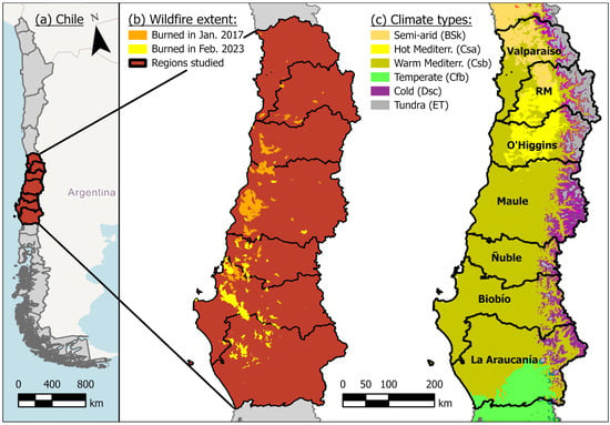
Figure 1.
Study area over (a) regions of Central Chile affected by (b) major wildfires in recent years with (c) various climate types.
2.3. Extreme Wildfire Events
Within the period of record of SMAP (launched in 2015), we analyzed the extreme wildfire events of 2017 and 2023 (Table 2). In both cases, we concentrated on the days when the fires and burned areas spread most extensively during 18–29 January 2017 and 2–11 February 2023 (Figure S1). We extracted the burned extents from MODIS, which was previously used in the region [7,33] and yielded areas consistent with other datasets [2,34]. As commonly defined, we considered the burned areas greater than 10,000 ha as “megafires” [35]. Other fires that remained smaller in size (despite being ignited) were regarded as “control areas.” For consistency, we confirmed that the megafires and control areas were located over similar land cover types, primarily comprised of needleleaf forests, broadleaf forests, woody savannas and savannas (Figures S2 and S3).

Table 2.
Extreme wildfire events included in this study.
2.4. Classification of Burned Areas Based on Soil Moisture
To explore the soil moisture conditions that allowed certain fires to reach such proportions, we calculated the mean soil moisture values every 10 days up to 6 months ahead of the spike in burned areas. Next, we focused on soil moisture in the dekad (i.e., 10-day lead time) prior to 18 January 2017 and 2 February 2023. We considered any SMAP pixels touching the megafires as “actual positive.” Other pixels throughout the control areas were regarded as “actual negative.” In this binary classification problem, we applied thresholds to identify relatively low soil moisture and determine the “predicted positive” and “predicted negative” of the megafires (Figure 2). Correctly labeled pixels were either True Positive (TP) or True Negative (TN). Incorrectly predicted classes were either False Positive (FP) or False Negative (FN). These confusions in classes were also referred to as Type I and Type II errors, respectively.
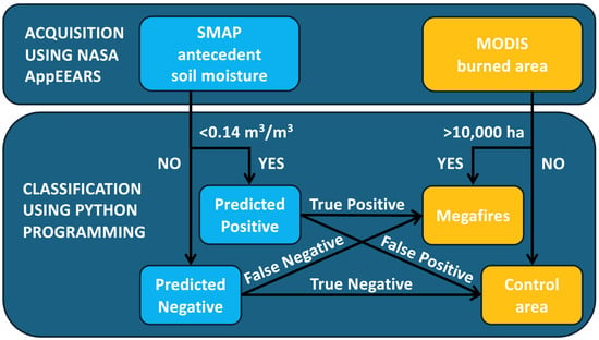
Figure 2.
Flowchart of the classification of burned areas from the Moderate Resolution Imaging Spectroradiometers (MODIS) using one critical threshold in antecedent soil moisture obtained from the Soil Moisture Active Passive (SMAP) mission.
2.5. Performance Metrics
To compare the performance of various thresholds, we used conventional Receiver Operating Characteristic (ROC) curves, which show the true positive rate as a function of the false positive rate. When a classification model can accurately discriminate between the positive and negative classes, the true positive rate (sensitivity) increases faster than the false positive rate (1—specificity), resulting in a greater Area Under the Curve (AUC). To best account for the size of the positive class (and potential dataset imbalance), we also plotted Precision–Recall Curves (PRC). Precision indicates how many positive predictions are relevant, while recall (also known as sensitivity) measures how many positive predictions are retrieved. As such, PRC plots give a more informative picture of the capability for the prediction of the positive class [36,37]. Last, the classification accuracy is the ratio of predictions that are correct, whether positive or negative. Performance metrics were calculated for 2017 and 2023 using the following equations [38]:
3. Results
3.1. Contrast in Soil Moisture between Megafires and Control Areas
Throughout the areas impacted by the 2017 megafires, the soil moisture decreased substantially over the course of the months from 1 August 2016 (0.46 ± 0.09 m3/m3) to 18 January 2017 (0.18 ± 0.10 m3/m3). In addition, the soil moisture values over this timeframe were generally lower within the footprints of the megafires than in the control areas (Figure 3). A consistent shift in the median values between each boxplot pair can be seen despite their respective variability. Beyond the median values, we also found that the distribution of soil moisture was further skewed (i.e., right tail more pronounced) across the areas later impacted by megafires (Figure 4). As such, 52.3% of the pixels over the megafires exhibited values below 0.14 m3/m3 in the prior 10 days. For reference, only 22.6% of the control areas presented these dry conditions. This skewness in antecedent soil moisture (with around half of the megafires below 0.14 m3/m3) could be observed consistently across a window of 4 to 19 days prior to the fire occurrence (Figure S4). This greater concentration of low values translated into a preponderance of dryer soil moisture, that can be observed spatially (i.e., red pixels) before the occurrence of megafires (Figure 5).
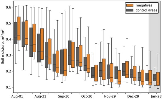
Figure 3.
Spatial variability in 10-day soil moisture across the megafires and control areas (111 and 86 pixels, respectively) throughout the six months prior to the spread of the 2017 wildfires (shaded in gray).
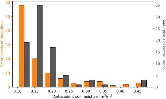
Figure 4.
Comparison of the distributions of soil moisture pixels across the megafires and control areas over the 10 days ahead of the 2017 wildfires.
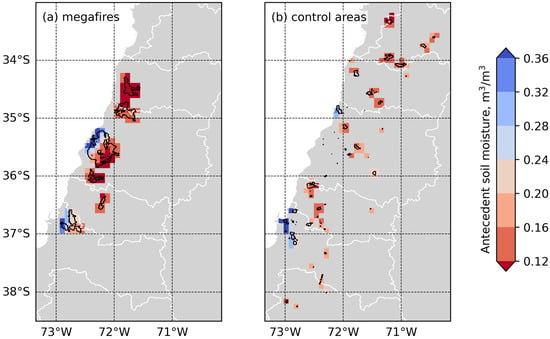
Figure 5.
Contrast in soil moisture across the (a) megafires and (b) control areas over the 10 days ahead of 2017 wildfires. Red and blue indicate drier and wetter conditions, respectively.
3.2. Critical Thresholds in Antecedent Soil Moisture
Aiming to differentiate between the moisture conditions ahead of the 2017 megafires, the ROC curves exhibited true positive rates exceeding their false positive rates (Figure 6a). The curve for each of the thresholds plotted left of the 1:1 line and indicated some skill for binary classification. The threshold of 0.14 m3/m3 had the largest AUC of ROC with 0.656, showing a greater ability to distinguish between the positive and negative classes in 2017. As for the PRC plot, we observed that the precision decreased as the recall increased for each of the thresholds, which was expected (Figure 6b). All of the thresholds that we examined consistently yielded higher precision than the no-skill baseline. For reference, if a model classified all soil moisture pixels as positive ahead of the 2017 wildfires, it would yield 100% recall but 56.3% accuracy. We found that the 0.12 m3/m3 threshold had the largest AUC of PRC thanks to a higher precision of 89.7%. However, it yielded substantially lower recall of 31.5%. In contrast, the 0.14 m3/m3 threshold retrieved 54.1% of the positive samples (i.e., recall) and identified 75.9% of the actual positives as positive (i.e., precision). As such, the 0.14 m3/m3 threshold appeared to better balance the success and errors in the predicted classes, showing a greater ability to map the megafires.
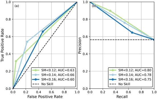
Figure 6.
Performance of various critical thresholds in antecedent soil moisture to classify burned areas ahead of the 2017 wildfires using (a) Receiver Operating Characteristic (ROC) curves and (b) Precision–Recall Curves (PRC).
3.3. Performance of Burned Area Classification
In the case of the 2017 wildfires, our prescribed threshold of 0.14 m3/m3 was able to classify every megafire, at least in part (Figure 7). One notable exception was a large fire below 36.5°S, contributing to some of the false negative labels (i.e., 51 out of 197 pixels) and the recall of 54.1% (Table 3). It is also worth noting that there was a low ratio of false positives (i.e., 9.6%), showing that low soil moisture was specifically found in the areas later affected by the megafires. The overall accuracy across the positive and negative classes in 2017 was 64.5%.
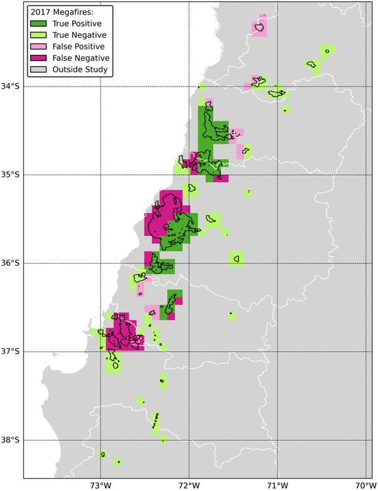
Figure 7.
Classification of the burned areas using a critical threshold of 0.14 m3/m3 in soil moisture over the 10 days prior to the 2017 wildfires.

Table 3.
Confusion matrix and performance metrics for 2017 burned areas.
For the 2023 wildfires, the critical threshold of 0.14 m3/m3 captured numerous true negatives (i.e., 111 out of 204 pixels), indicating high soil moisture in the control areas (Figure 8). However, we also obtained a large ratio of false negatives (i.e., 31.4%), showing that the soil moisture conditions prior to the megafires were also high (Table 4). The prescribed threshold identified only four true positive pixels, resulting in low precision and recall of 13.8% and 5.9%, respectively. Overall, the accuracy of the 2023 classification was 56.4%.
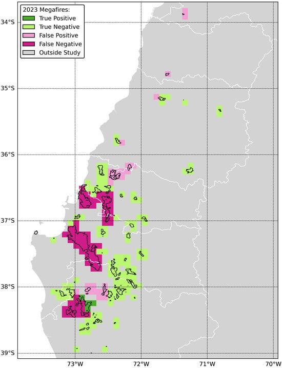
Figure 8.
Classification of the burned areas using a critical threshold of 0.14 m3/m3 in soil moisture over the 10 days prior to the 2023 wildfires.

Table 4.
Confusion matrix and performance metrics for 2023 burned areas.
4. Discussion
4.1. Current Limitations of Soil Moisture in Fire Forecast
Recent studies have suggested that wildfire occurrence could be linked to soil moisture as a single physical variable [22,27,39]. However, soil moisture information can be formulated using different measures, such as absolute thresholds, scaled indices and anomalies [28]. In addition, fire activity can be regulated by soil moisture in two ways: (1) wet soil moisture long ahead of the fires can increase fuel accumulation and (2) dry soil moisture closer to the fire can increase fuel flammability [9,10,11,17,40]. These opposing trends add a layer of complexity to the relationship between wildfires and soil moisture. At present, the available soil moisture information is constrained by the spatial resolution (9 km × 9 km) and revisit time (2–3 days) provided by the SMAP mission. In this sense, a single pixel from SMAP can include areas both within and outside the fire zone and encompass various land cover types. These contrasting vegetation types respond differently in time to soil moisture limitations [41]. The ground penetration of SMAP is also shallower over forests than in grasslands due to signal propagation through the canopy [26]. In addition, SMAP data are masked along oceans and coastlines. In this context, the practical application of SMAP to monitor fire danger remains largely untested.
4.2. New Insights into Soil Moisture as an Indicator of Burned Areas
While the megafires and smaller fires (i.e., control areas) burned across generally consistent land cover and climate types, a small number of fires were responsible for large burned areas. Therefore, we examined the ground conditions that might have allowed these fires to reach such proportions, in a matter of days. By leveraging operational satellite measurements of soil moisture, we found that the 2017 megafires were more likely to have exhibited substantially drier conditions in a window of 4 to 19 days prior. This is a shorter latency period than the 1- to 2-month lead time used by others to link high fire activity with SMAP observations [24,25,27]. Using a critical threshold that balanced recall and precision, we were able to differentiate certain soil moisture conditions and map every megafire that occurred in 2017, at least in part.
For 2023, the same threshold was unable to identify specific patterns in soil moisture ahead of the megafires. To some extent, this can be linked to the different pre-fire conditions and the localized effect of fast and dry easterly winds [42]. It should be emphasized that the wildfire characteristics vary greatly from region to region in Chile [43]. The 2023 wildfires were concentrated in an area (between 36.2–38.7°S) that was classified by others as part of a different climatic cluster [44]. As such, it might be useful to view the 2017 and 2023 wildfires as separate case studies, with low antecedent soil moisture being a stronger driver of the former. Note that, in the same way, wet conditions do not necessarily prevent a fire from spreading, and high fire susceptibility does not mean that ignition will occur. In Chile, most wildfires are caused by people [8,34,45]. Therefore, it is important to note that the present work is not intended to predict the exact extent and occurrence of wildfires, but rather to better understand the relationship between satellite-based soil moisture and extreme wildfire events.
4.3. Societal Implications
Due to climate and land use change, the intensity and damage caused by future wildfires are predicted to increase [46,47,48,49,50,51]. In Central Chile, the concurrence of large climate oscillations and an extended drought fueled the extreme wildfires of 2017 and 2023 [6]. With almost three million people inhabiting WUI areas, it is critical to accurately monitor the wildfire danger across Central Chile [7]. The agency that administers forest policies and wildfire management in Chile is the Corporación Nacional Forestal (CONAF) under the oversight of the Ministry of Agriculture. CONAF uses a fire forecast system known as KITRAL (meaning “fire” in the Mapuche language). It was developed in the early 1990s, was updated over time and remains operational to this day [8]. At present, KITRAL monitors the daily probability of wildfire occurrence based on meteorological data such as the air temperature, relative humidity, wind speed and a drought factor [43]. However, the same authors concede that “numerous technical options exist [for meteorological factors] that would improve the wildfire risk index currently used in Chile.” We argue that one such alternative is the incorporation of soil moisture, which can better capture the fuel conditions and wildfire danger than traditional drought indices [17,18,19,20]. Our work demonstrated that critical thresholds in soil moisture can be useful to identify certain conditions more conducive to megafires in Chile. We believe that it is critical for soil moisture information to be formulated in a form that can be easily communicated (unlike more complex drought indices) and adopted among various stakeholders [28]. This is all the more relevant as case studies have shown that the spatial planning system in Chile previously failed to incorporate new wildfire information [52]. In this context, our research has the potential to provide granular spatial information in support of wildfire mitigation at the local scale instead of the national level [53]. It also takes place within a broader call to action for preventive fire management strategies, sustainable land use planning and social adaptation [45,49,54].
4.4. Future Work
A potential next step would be to analyze the added value of a finer-resolution soil moisture dataset [9]. Alternatively, one could also explore ground conditions further below the surface and focus on the root zone soil moisture [24]. Another area of study could involve looking above and further examining the canopy stress index [55]. Ultimately, this work can be expanded to additional wildfire events and other parts of the world.
5. Conclusions
Over the last decade, parts of Chile have faced extreme wildfires, in January 2017 and February 2023, which burned around 750,000 ha and affected the many people living in the WUI areas and beyond. Our work leveraged remotely sensed data from SMAP to analyze the soil moisture conditions that allowed a small number of fires to propagate rapidly and take large proportions. Specifically, we examined how the soil moisture varied in the months and days before the megafires (i.e., burned areas >10,000 ha) and smaller fires (i.e., control areas), despite both areas sharing consistent climate and land cover types. In the 10 days prior, more than half of the 2017 megafires exhibited antecedent soil moisture below a single value of 0.14 m3/m3, with the same conditions less likely to be found in the control areas. Using this value as a threshold, we were able to map every megafire that occurred in 2017 (at least in part). This classification balanced the success and errors in prediction, yielding 54.1% recall and 75.9% precision (well above the 56.3% baseline). For 2023, the burned areas could not be differentiated as accurately, potentially due to the different pre-fire conditions and the wildfire characteristics varying from region to region. To the best of our knowledge, this study is the first to investigate the conditions specific to megafires from the vantage point of SMAP. What makes this work most novel is the application of critical thresholds for low antecedent soil moisture that showed some predictive skill to identify conditions more conducive to megafires. Relying solely on publicly available satellite data, this work can be expanded to additional wildfire events and other parts of the world.
Supplementary Materials
The following supporting information can be downloaded at: https://www.mdpi.com/article/10.3390/rs16132457/s1, Figure S1: MODIS burned areas across the study region for ordinal days in 2017 and 2023; Figure S2: MODIS land cover types burned during the 2023 wildfires; Figure S3: MODIS land cover types burned during the 2017 wildfires; Figure S4: Soil moisture distributions over the 5, 10, 15, 20, and 25 days ahead of the 2017 wildfires.
Author Contributions
Conceptualization, B.D.G., A.A., Q.D., K.W.R. and V.L.; methodology, B.D.G. and A.A.; software, B.D.G.; validation, B.D.G.; formal analysis, B.D.G.; data curation, B.D.G. and A.A.; writing—original draft preparation, B.D.G.; writing—review and editing, B.D.G., A.A., Q.D., K.W.R. and V.L.; visualization, B.D.G.; supervision, K.W.R. and V.L.; project administration, B.D.G.; funding acquisition, K.W.R. and V.L. All authors have read and agreed to the published version of the manuscript.
Funding
This material is based upon work supported by NASA through contract NNL16AA05C. This work was also made possible by funding from the University of Virginia School of Engineering and Applied Science and the Jefferson Scholars Foundation.
Data Availability Statement
The MODIS burned area and land cover types as well as the SMAP soil moisture data used in this study are publicly available via the NASA AppEEARS portal at https://appeears.earthdatacloud.nasa.gov/ (accessed on 27 May 2024).
Acknowledgments
We would like to recognize Gonzalo Esteban Tapia Koch (CONAF) and Jorge Andrés Saavedra Saldías (CONAF) for providing useful context and guidance on this project. We are also grateful to Fernando Vásquez and Andrés Rodríguez from the Embassy of Chile’s Agriculture Office (Washington, DC), who facilitated an international partnership and fruitful collaboration.
Conflicts of Interest
The authors declare no conflicts of interest.
References
- Bowman, D.M.; Moreira-Muñoz, A.; Kolden, C.A.; Chávez, R.O.; Muñoz, A.A.; Salinas, F.; González-Reyes, Á.; Rocco, R.; de la Barrera, F.; Williamson, G.J.; et al. Human–environmental drivers and impacts of the globally extreme 2017 Chilean fires. Ambio 2019, 48, 350–362. [Google Scholar] [CrossRef] [PubMed]
- De la Barrera, F.; Barraza, F.; Favier, P.; Ruiz, V.; Quense, J. Megafires in Chile 2017: Monitoring multiscale environmental impacts of burned ecosystems. Sci. Total Environ. 2018, 637, 1526–1536. [Google Scholar] [CrossRef] [PubMed]
- González, M.E.; Gómez-González, S.; Lara, A.; Garreaud, R.; Díaz-Hormazábal, I. The 2010–2015 Megadrought and its influence on the fire regime in central and south-central Chile. Ecosphere 2018, 9, e02300. [Google Scholar] [CrossRef]
- Garreaud, R.D.; Alvarez-Garreton, C.; Barichivich, J.; Boisier, J.P.; Christie, D.; Galleguillos, M.; LeQuesne, C.; McPhee, J.; Zambrano-Bigiarini, M. The 2010–2015 megadrought in central Chile: Impacts on regional hydroclimate and vegetation. Hydrol. Earth Syst. Sci. 2017, 21, 6307–6327. [Google Scholar] [CrossRef]
- Garreaud, R.D.; Boisier, J.P.; Rondanelli, R.; Montecinos, A.; Sepúlveda, H.H.; Veloso-Aguila, D. The central Chile mega drought (2010–2018): A climate dynamics perspective. Int. J. Climatol. 2020, 40, 421–439. [Google Scholar] [CrossRef]
- Cordero, R.R.; Feron, S.; Damiani, A.; Carrasco, J.; Karas, C.; Wang, C.; Kraamwinkel, C.T.; Beaulieu, A. Extreme fire weather in Chile driven by climate change and El Niño–Southern Oscillation (ENSO). Sci. Rep. 2024, 14, 1974. [Google Scholar] [CrossRef] [PubMed]
- Sarricolea, P.; Serrano-Notivoli, R.; Fuentealba, M.; Hernández-Mora, M.; De la Barrera, F.; Smith, P.; Meseguer-Ruiz, Ó. Recent wildfires in Central Chile: Detecting links between burned areas and population exposure in the wildland urban interface. Sci. Total Environ. 2020, 706, 135894. [Google Scholar] [CrossRef]
- Úbeda, X.; Sarricolea, P. Wildfires in Chile: A review. Glob. Planet. Chang. 2016, 146, 152–161. [Google Scholar] [CrossRef]
- Chaparro, D.; Vall-Llossera, M.; Piles, M.; Camps, A.; Rüdiger, C.; Riera-Tatché, R. Predicting the extent of wildfires using remotely sensed soil moisture and temperature trends. IEEE J. Sel. Top. Appl. Earth Obs. Remote Sens. 2016, 9, 2818–2829. [Google Scholar] [CrossRef]
- Krueger, E.S.; Ochsner, T.E.; Engle, D.M.; Carlson, J.D.; Twidwell, D.; Fuhlendorf, S.D. Soil moisture affects growing-season wildfire size in the southern Great Plains. Soil Sci. Soc. Am. J. 2015, 79, 1567–1576. [Google Scholar] [CrossRef]
- Sungmin, O.; Hou, X.; Orth, R. Observational evidence of wildfire-promoting soil moisture anomalies. Sci. Rep. 2020, 10, 11008. [Google Scholar] [CrossRef]
- Sharma, S.; Carlson, J.D.; Krueger, E.S.; Engle, D.M.; Twidwell, D.; Fuhlendorf, S.D.; Patrignani, A.; Feng, L.; Ochsner, T.E. Soil moisture as an indicator of growing-season herbaceous fuel moisture and curing rate in grasslands. Int. J. Wildland Fire 2020, 30, 57–69. [Google Scholar] [CrossRef]
- Jia, S.; Kim, S.H.; Nghiem, S.V.; Kafatos, M. Estimating live fuel moisture using SMAP L-band radiometer soil moisture for Southern California, USA. Remote Sens. 2019, 11, 1575. [Google Scholar] [CrossRef]
- Pellizzaro, G.; Cesaraccio, C.; Duce, P.; Ventura, A.; Zara, P. Relationships between seasonal patterns of live fuel moisture and meteorological drought indices for Mediterranean shrubland species. Int. J. Wildland Fire 2007, 16, 232–241. [Google Scholar] [CrossRef]
- Qi, Y.; Dennison, P.E.; Spencer, J.; Riaño, D. Monitoring live fuel moisture using soil moisture and remote sensing proxies. Fire Ecol. 2012, 8, 71–87. [Google Scholar] [CrossRef]
- Bianchi, L.O.; Defossé, G.E. Live fuel moisture content and leaf ignition of forest species in Andean Patagonia, Argentina. Int. J. Wildland Fire 2015, 24, 340–348. [Google Scholar] [CrossRef]
- Forkel, M.; Thonicke, K.; Beer, C.; Cramer, W.; Bartalev, S.; Schmullius, C. Extreme fire events are related to previous-year surface moisture conditions in permafrost-underlain larch forests of Siberia. Environ. Res. Lett. 2012, 7, 044021. [Google Scholar] [CrossRef]
- Krueger, E.S.; Ochsner, T.E.; Quiring, S.M.; Engle, D.M.; Carlson, J.D.; Twidwell, D.; Fuhlendorf, S.D. Measured soil moisture is a better predictor of large growing-season wildfires than the Keetch–Byram Drought Index. Soil Sci. Soc. Am. J. 2017, 81, 490–502. [Google Scholar] [CrossRef]
- Vinodkumar; Dharssi, I.; Bally, J.; Steinle, P.; McJannet, D.; Walker, J. Comparison of soil wetness from multiple models over Australia with observations. Water Resour. Res. 2017, 53, 633–646. [Google Scholar] [CrossRef]
- Holgate, C.M.; Van DIjk, A.I.; Cary, G.J.; Yebra, M. Using alternative soil moisture estimates in the McArthur Forest Fire Danger Index. Int. J. Wildland Fire 2017, 26, 806–819. [Google Scholar] [CrossRef]
- Kerr, Y.H.; Waldteufel, P.; Richaume, P.; Wigneron, J.P.; Ferrazzoli, P.; Mahmoodi, A.; Al Bitar, A.; Delwart, S. The SMOS soil moisture retrieval algorithm. IEEE Trans. Geosci. Remote Sens. 2012, 50, 1384–1403. [Google Scholar] [CrossRef]
- Ambadan, J.T.; Oja, M.; Gedalof, Z.E.; Berg, A.A. Satellite-observed soil moisture as an indicator of wildfire risk. Remote Sens. 2020, 12, 1543. [Google Scholar] [CrossRef]
- Entekhabi, D.; Njoku, E.G.; O’Neill, P.E.; Kellogg, K.H.; Crow, W.T.; Edelstein, W.N.; Entin, J.K.; Goodman, S.D.; Jackson, T.J.; Johnson, J.; et al. The soil moisture active passive (SMAP) mission. Proc. IEEE 2010, 98, 704–716. [Google Scholar] [CrossRef]
- Chaleplis, K.; Walters, A.; Fang, B.; Lakshmi, V.; Gemitzi, A. A Soil Moisture and Vegetation-Based Susceptibility Mapping Approach to Wildfire Events in Greece. Remote Sens. 2024, 16, 1816. [Google Scholar] [CrossRef]
- Dadap, N.C.; Cobb, A.R.; Hoyt, A.M.; Harvey, C.F.; Konings, A.G. Satellite soil moisture observations predict burned area in Southeast Asian peatlands. Environ. Res. Lett. 2019, 14, 094014. [Google Scholar] [CrossRef]
- Rigden, A.J.; Powell, R.S.; Trevino, A.; McColl, K.A.; Huybers, P. Microwave retrievals of soil moisture improve grassland wildfire predictions. Geophys. Res. Lett. 2020, 47, e2020GL091410. [Google Scholar] [CrossRef]
- Sazib, N.; Bolten, J.D.; Mladenova, I.E. Leveraging NASA soil moisture active passive for assessing fire susceptibility and potential impacts over Australia and California. IEEE J. Sel. Top. Appl. Earth Obs. Remote Sens. 2021, 15, 779–787. [Google Scholar] [CrossRef]
- Krueger, E.S.; Levi, M.R.; Achieng, K.O.; Bolten, J.D.; Carlson, J.D.; Coops, N.C.; Holden, Z.A.; Magi, B.I.; Rigden, A.J.; Ochsner, T.E. Using soil moisture information to better understand and predict wildfire danger: A review of recent developments and outstanding questions. Int. J. Wildland Fire 2022, 32, 111–132. [Google Scholar] [CrossRef]
- Giglio, L.; Justice, C.; Boschetti, L.; Roy, D. MODIS/Terra + Aqua Burned Area Monthly L3 Global 500m SIN Grid, Version 6.1 [Data Set]. NASA EOSDIS Land Processes Distributed Active Archive Center, 2021. Available online: https://lpdaac.usgs.gov/products/mcd64a1v061/ (accessed on 29 March 2024).
- Friedl, M.; Sulla-Menashe, D. MODIS/Terra + Aqua Land Cover Type Yearly L3 Global 500 m SIN Grid, Version 6.1 [Data Set]. NASA EOSDIS Land Processes Distributed Active Archive Center, 2022. Available online: https://lpdaac.usgs.gov/products/mcd12q1v061/ (accessed on 27 May 2024).
- O’Neill, P.E.; Chan, S.; Njoku, E.G.; Jackson, T.; Bindlish, R.; Chaubell, J.; Colliander, A. SMAP Enhanced L3 Radiometer Global and Polar Grid Daily 9 km EASE-Grid Soil Moisture, Version 5 [Data Set]. NASA National Snow and Ice Data Center Distributed Active Archive Center—Boulder, Colorado, USA, 2021. Available online: https://nsidc.org/data/spl3smp_e/versions/5 (accessed on 22 May 2024).
- Beck, H.E.; McVicar, T.R.; Vergopolan, B.; Lutsko, N.J.; Dufour, A.; Zeng, Z.; Jiang, X.; van Dijk, A.I.J.M.; Miralles, D.G. High-resolution (1 km) Köppen-Geiger maps for 1901–2099 based on constrained CMIP6 projections. Sci. Data 2023, 10, 724. [Google Scholar] [CrossRef]
- Dacre, H.F.; Crawford, B.R.; Charlton-Perez, A.J.; Lopez-Saldana, G.; Griffiths, G.H.; Veloso, J.V. Chilean wildfires: Probabilistic prediction, emergency response, and public communication. Bull. Am. Meteorol. Soc. 2018, 99, 2259–2274. [Google Scholar] [CrossRef]
- McWethy, D.B.; Pauchard, A.; García, R.A.; Holz, A.; González, M.E.; Veblen, T.T.; Stahl, J.; Currey, B. Landscape drivers of recent fire activity (2001-2017) in south-central Chile. PLoS ONE 2018, 13, e0201195. [Google Scholar] [CrossRef] [PubMed]
- Linley, G.D.; Jolly, C.J.; Doherty, T.S.; Geary, W.L.; Armenteras, D.; Belcher, C.M.; Duane, A.; Fletcher, M.-S.; Giorgis, M.A. What do you mean,‘megafire’? Glob. Ecol. Biogeogr. 2022, 31, 1906–1922. [Google Scholar] [CrossRef]
- Davis, J.; Goadrich, M. The relationship between Precision-Recall and ROC curves. In Proceedings of the 23rd International Conference on Machine Learning, Pittsburgh, PA, USA, 25–29 June 2006; pp. 233–240. [Google Scholar] [CrossRef]
- Saito, T.; Rehmsmeier, M. The precision-recall plot is more informative than the ROC plot when evaluating binary classifiers on imbalanced datasets. PLoS ONE 2015, 10, e0118432. [Google Scholar] [CrossRef] [PubMed]
- Fawcett, T. An introduction to ROC analysis. Pattern Recognit. Lett. 2006, 27, 861–874. [Google Scholar] [CrossRef]
- Schaefer, A.J.; Magi, B.I. Land-cover dependent relationships between fire and soil moisture. Fire 2019, 2, 55. [Google Scholar] [CrossRef]
- Jensen, D.; Reager, J.T.; Zajic, B.; Rousseau, N.; Rodell, M.; Hinkley, E. The sensitivity of US wildfire occurrence to pre-season soil moisture conditions across ecosystems. Environ. Res. Lett. 2018, 13, 014021. [Google Scholar] [CrossRef] [PubMed]
- Teuling, A.J.; Seneviratne, S.I.; Stöckli, R.; Reichstein, M.; Moors, E.; Ciais, P.; Luyssaert, S.; van den Hurk, B.; Ammann, C.; Bernhofer, C.; et al. Contrasting response of European forest and grassland energy exchange to heatwaves. Nat. Geosci. 2010, 3, 722–727. [Google Scholar] [CrossRef]
- Goffin, B.D.; Aryal, A.; Deppert, Q. Chile Wildland Fires: Augmenting Wildfire Risk Assessment Efforts with Satellite-based Measurements of Soil Moisture and Vegetation Health in Central and South-Central Chile [Unpublished manuscript]. NASA DEVELOP National Program, Virginia—LaRC, 2023. Available online: https://ntrs.nasa.gov/api/citations/20230012417/downloads/2023Sum_PUP_ChileWildlandFires_TechPaper_FD_v2.docx (accessed on 25 June 2024).
- Castillo, M.E.; Julio-Alvear, G.; Salinas, R.G. Current wildfire risk status and forecast in Chile: Progress and future challenges. In Wildfire Hazards, Risks and Disasters; Elsevier: Amsterdam, The Netherlands, 2015; pp. 59–75. [Google Scholar] [CrossRef]
- Cortez, D.; Herrera, S.; Araya-Osses, D.; Caroca, C.; Padilla, R.; Manuel Uribe, J.; Paneque, M. Topoclimatic zoning of continental Chile. J. Maps 2021, 17, 114–124. [Google Scholar] [CrossRef]
- Pozo, R.A.; Galleguillos, M.; González, M.E.; Vásquez, F.; Arriagada, R. Assessing the socio-economic and land-cover drivers of wildfire activity and its spatiotemporal distribution in south-central Chile. Sci. Total Environ. 2022, 810, 152002. [Google Scholar] [CrossRef]
- Ciocca, I.; Fernández, A.; Jaque, E.; Justino, F.; Shumacher, V.; da Silva, A.S.; Muñoz, A.; de la Barrera, F. Increased wildfire hazard along South-Central Chile under the RCP8. 5 scenario as revealed by high-resolution modeling. Environ. Res. Lett. 2023, 18, 034023. [Google Scholar] [CrossRef]
- Doerr, S.H.; Santín, C. Global trends in wildfire and its impacts: Perceptions versus realities in a changing world. Philos. Trans. R. Soc. B Biol. Sci. 2016, 371, 20150345. [Google Scholar] [CrossRef]
- Flannigan, M.; Cantin, A.S.; De Groot, W.J.; Wotton, M.; Newbery, A.; Gowman, L.M. Global wildland fire season severity in the 21st century. For. Ecol. Manag. 2013, 294, 54–61. [Google Scholar] [CrossRef]
- Gómez-González, S.; González, M.E.; Paula, S.; Díaz-Hormazábal, I.; Lara, A.; Delgado-Baquerizo, M. Temperature and agriculture are largely associated with fire activity in Central Chile across different temporal periods. For. Ecol. Manag. 2019, 433, 535–543. [Google Scholar] [CrossRef]
- Moritz, M.A.; Batllori, E.; Bradstock, R.A.; Gill, A.M.; Handmer, J.; Hessburg, P.F.; Leonard, J.; McCaffrey, S.; Odion, D.C.; Schoennagel, T.; et al. Learning to coexist with wildfire. Nature 2014, 515, 58–66. [Google Scholar] [CrossRef] [PubMed]
- Pechony, O.; Shindell, D.T. Driving forces of global wildfires over the past millennium and the forthcoming century. Proc. Natl. Acad. Sci. USA 2010, 107, 19167–19170. [Google Scholar] [CrossRef] [PubMed]
- Gonzalez-Mathiesen, C. Challenges in Developing Wildfire Understanding from Wildfire Information through Spatial Planning Processes. Sustainability 2024, 16, 420. [Google Scholar] [CrossRef]
- Gonzalez-Mathiesen, C.; March, A. Long-established rules and emergent challenges: Spatial planning and wildfires in Chile. Int. Plan. Stud. 2023, 28, 37–53. [Google Scholar] [CrossRef]
- González, M.E.; Syphard, A.D.; Fischer, A.P.; Muñoz, A.A.; Miranda, A. Chile’s Valparaíso hills on fire. Science 2024, 383, 1424. [Google Scholar] [CrossRef]
- Lee, J.H. Prediction of large-scale wildfires with the canopy stress index derived from soil moisture active passive. IEEE J. Sel. Top. Appl. Earth Obs. Remote Sens. 2020, 14, 2096–2102. [Google Scholar] [CrossRef]
Disclaimer/Publisher’s Note: The statements, opinions and data contained in all publications are solely those of the individual author(s) and contributor(s) and not of MDPI and/or the editor(s). MDPI and/or the editor(s) disclaim responsibility for any injury to people or property resulting from any ideas, methods, instructions or products referred to in the content. |
© 2024 by the authors. Licensee MDPI, Basel, Switzerland. This article is an open access article distributed under the terms and conditions of the Creative Commons Attribution (CC BY) license (https://creativecommons.org/licenses/by/4.0/).