

Imagery Time Series Cloud Removal and Classification Using Long Short Term Memory Neural Networks


Abstract

1. Introduction
2. Study Area
3. Methodology
3.1. Data Set and Preprocessing
3.2. Detection and Filling of Missing Pixels Due to Clouds or Shadows
3.3. Reflectance Time-Series Classification
3.3.1. Training Areas and Classification Scheme
3.3.2. Features
- Tasseled cap brightness (TCB) [77] attempts to highlight spectral information from satellite imagery that detects variations in soil reflectance (Equation (3)):where B1, B2 and B3 are the blue (B), green (G) and red (R) bands, respectively; B8 is the NIR band; and B11 and B12 are the SWIR of the S2A MSI. A more recent formulation can be found in [78].
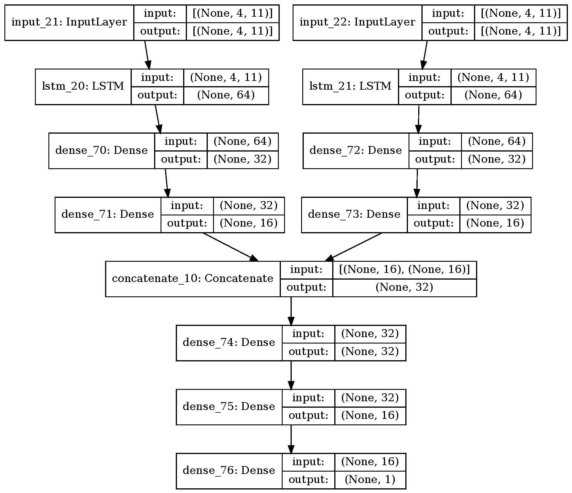
3.3.3. Models
3.4. Validation
4. Results
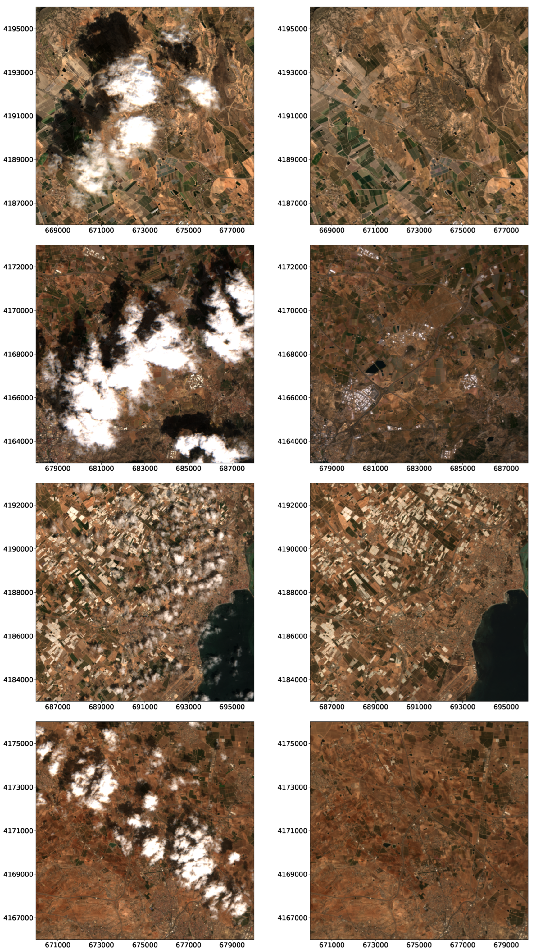
4.1. Cloud Removal
4.2. Classification
5. Discussion
6. Conclusions
Author Contributions
Funding
Data Availability Statement
Conflicts of Interest
Abbreviations
| CNN | Convolutional Neural Network |
| DL | Deep Learning |
| DPSVI | Dual Polarization SAR Vegetation Index |
| ESA | European Spatial Agency |
| GRD | Ground Range Detected |
| IW | Interferometric Wide |
| LSTM | Long Short Term Memory |
| LULC | Land Use and Land Cover |
| NDBI | Normalized Bald Index |
| NDVI | Normalized Vegetation Index |
| NDWI | Normalized Water Index |
| PNOA | Spanish Plan of National Ortophotography |
| RF | Random Forest |
| RNN | Recurrent Neural Network |
| RS | Remote Sensing |
| SAR | Synthetic Aperture Radar |
| TOA | Top Of the Atmosphere |
References
- Watson, R.; Noble, I.R.; Bolin, B.; Ravindranath, N.; Verardo, D.; Dokken, D. Land Use, Land-Use Change and Forestry: A Special Report of the Intergovernmental Panel on Climate Change; Cambridge University Press: Cambridge, UK, 2000. [Google Scholar]
- Mason, P.; Manton, M.; Harrison, D.; Belward, A.; Thomas, A.; Dawson, D. The Second Report on the Adequacy of the Global Observing Systems for Climate in Support of the UNFCCC. Technical Report 82, 74, GCOS Rep. 2003. Available online: https://stratus.ssec.wisc.edu/igos/docs/Second_Adequacy_Report.pdf (accessed on 6 June 2024).
- Naeem, S.; Cao, C.; Fatima, K.; Acharya, B. Landscape greening policies-based land use/land cover simulation for Beijing and Islamabad—An implication of sustainable urban ecosystems. Sustainability 2018, 10, 1049. [Google Scholar] [CrossRef]
- Carranza-García, M.; García-Gutiérrez, J.; Riquelme, J. A Framework for Evaluating Land Use and Land Cover Classification Using Convolutional Neural Networks. Remote Sens. 2019, 11, 274. [Google Scholar] [CrossRef]
- Wambugu, N.; Chen, Y.; Xiao, Z.; Wei, M.; Bello, S.; Junior, J.; Li, J. A Hybrid Deep Convolutional Neural Network for Accurate Land Cover Classification. Int. J. Appl. Earth Obs. Geoinf. 2021, 103, 102515. [Google Scholar] [CrossRef]
- Yao, X.; Yang, H.; Wu, Y.; Wu, P.; Wang, B.; Zhou, X.; Wang, S. Land Use Classification of the Deep Convolutional Neural Network Method Reducing the Loss of Spatial Features. Sensors 2019, 19, 2792. [Google Scholar] [CrossRef] [PubMed]
- Andrew, M.; Wulder, M.; Nelson, T. Potential contributions of remote sensing to ecosystem service assessments. Prog. Phys. Geogr. 2014, 38, 328–353. [Google Scholar] [CrossRef]
- European Union. Commission implementing regulation (eu) 2018/746 of 18 May 2018 amending implementing regulation (eu) no 809/2014 as regards modification of single applications and payment claims and checks. Off. J. Eur. Union 2018, 61, 1–7. [Google Scholar]
- Campos-Taberner, M.; García-Haro, F.; Martínez, B.; Izquierdo-Verdiguier, E.; Atzberger, C.; Camps-Valls, G.; Gilabert, M. Understanding deep learning in land use classification based on Sentinel-2 time series. Sci. Rep. 2020, 10, 17188. [Google Scholar] [CrossRef] [PubMed]
- Yan, J.; Liu, J.; Wang, L.; Liang, D.; Cao, Q.; Zhang, W.; Peng, J. Land-Cover Classification With Time-Series Remote Sensing Images by Complete Extraction of Multiscale Timing Dependence. IEEE J. Sel. Top. Appl. Earth Obs. Remote Sens. 2022, 15, 1953–1967. [Google Scholar] [CrossRef]
- Zhong, L.; Hu, L.; Zhou, H. Deep learning based multi-temporal crop classification. Remote Sens. Environ. 2019, 221, 430–443. [Google Scholar] [CrossRef]
- Campos-Taberner, M.; Romero-Soriano, A.; Gatta, C.; Camps-Valls, G.; Lagrange, A.; Le Saux, B.; Tuia, D. Processing of extremely high-resolution lidar and RGB data: Outcome of the 2015 IEEE GRSS data fusion contest-part a: 2-d contest. IEEE J. Sel. Top. Appl. Earth Observ. Remote Sens. 2016, 9, 5547–5559. [Google Scholar] [CrossRef]
- Liu, T.; Abd-Elrahman, A.; Morton, J.; Wilhelm, V. Comparing fully convolutional networks, random forest, support vector machine, and patch-based deep convolutional neural networks for object-based wetland mapping using images from small unmanned aircraft system. GISci. Remote Sens. 2018, 55, 243–264. [Google Scholar] [CrossRef]
- Li, X.; Wu, X. Constructing Long Short-Term Memory based Deep Recurrent Neural Networks for Large Vocabulary Speech Recognition. arXiv 2015, arXiv:1410.4281. [Google Scholar]
- Murad, A.; Pyun, J.Y. Deep Recurrent Neural Networks for Human Activity Recognition. Sensors 2017, 17, 2556. [Google Scholar] [CrossRef] [PubMed]
- Yan, R.; Liao, J.; Yang, J.; Sun, W.; Nong, M.; Li, F. Multi-hour and multi-site air quality index forecasting in Beijing using CNN, LSTM, CNN-LSTM, and spatiotemporal clustering. Expert Syst. Appl. 2021, 169, 114513. [Google Scholar] [CrossRef]
- Ndikumana, E.; Ho Tong Minh, D.; Baghdadi, N.; Courault, D.; Hossard, L. Deep recurrent neural network for agricultural classification using multitemporal SAR Sentinel-1 for Camargue, France. Remote Sens. 2018, 10, 1217. [Google Scholar] [CrossRef]
- Mou, L.; Bruzzone, L.; Zhu, X. Learning Spectral-Spatial-Temporal Features via a Recurrent Convolutional Neural Network for Change Detection in Multispectral Imagery. IEEE Trans. Geosci. Remote Sens. 2019, 57, 924–935. [Google Scholar] [CrossRef]
- Zhang, L.; Zhang, L.; Du, B. Deep learning for remote sensing data: A technical tutorial on the state of the art. IEEE Geosci. Remote Sens. Mag. 2016, 4, 22–40. [Google Scholar] [CrossRef]
- Zhu, X.; Tuia, D.; Mou, L.; Xia, G.; Zhang, L.; Xu, F.; Fraundorfer, F. Deep learning in remote sensing: A comprehensive review and list of resources. IEEE Geosci. Remote Sens. Mag. 2017, 5, 8–36. [Google Scholar] [CrossRef]
- Ma, L.; Liu, Y.; Zhang, X.; Ye, Y.; Yin, G.; Johnson, B. Deep learning in remote sensing applications: A meta-analysis and review. ISPRS J. Photogramm. Remote Sens. 2019, 152, 166–177. [Google Scholar] [CrossRef]
- Simón-Sánchez, A.; González-Piqueras, J.; de la Ossa, L.; Calera, A. Convolutional Neural Networks for Agricultural Land Use Classification from Sentinel-2 Image Time Series. Remote Sens. 2022, 14, 5373. [Google Scholar] [CrossRef]
- Gómez, C.; White, J.; Wulder, M. Optical remotely sensed time series data for land cover classification: A review. Isprs J. Photogramm. Remote Sens. 2016, 116, 55–72. [Google Scholar] [CrossRef]
- Rogan, J.; Franklin, J.; Roberts, D. A comparison of methods for monitoring multitemporal vegetation change using Thematic Mapper imagery. Remote Sens. Environ. 2002, 80, 143–156. [Google Scholar] [CrossRef]
- Xie, Y.; Sha, Z.; Yu, M. Remote sensing imagery in vegetation mapping: A review. J. Plant Ecol. 2008, 1, 9–23. [Google Scholar] [CrossRef]
- Gómez, C.; White, J.; Wulder, M.; Alejandro, P. Historical forest biomass dynamics modelled with Landsat spectral trajectories. ISPRS J. Photogramm. Remote Sens. 2014, 93, 14–28. [Google Scholar] [CrossRef]
- Franklin, S.; Ahmed, O.; Wulder, M.; White, J.; Hermosilla, T.; Coops, N. Large area mapping of annual land cover dynamics using multi-temporal change detection and classification of Landsat time-series data. Can. J. Remote Sens. 2015, 41, 293–314. [Google Scholar] [CrossRef]
- Gomariz-Castillo, F.; Alonso-Sarria, F.; Cánovas-García, F. Improving Classification Accuracy of Multi-Temporal Landsat Images by Assessing the Use of Different Algorithms, Textural and Ancillary Information for a Mediterranean Semiarid Area from 2000 to 2015. Remote Sens. 2017, 9, 1058. [Google Scholar] [CrossRef]
- Müller, H.; Rufin, P.; Griffiths, P.; Barros Siqueira, A.; Hostert, P. Mining dense Landsat time series for separating cropland and pasture in a heterogeneous Brazilian savanna landscape. Remote Sens. Environ. 2014, 156, 490–499. [Google Scholar] [CrossRef]
- Senf, C.; Leitão, P.; Pflugmacher, D.; van der Linden, S.; Hostert, P. Mapping land cover in complex Mediterranean landscapes using Landsat: Improved classification accuracies from integrating multi-seasonal and synthetic imagery. Remote Sens. Environ. 2015, 156, 527–536. [Google Scholar] [CrossRef]
- Valdivieso-Ros, C.; Alonso-Sarria, F.; Gomariz-Castillo, F. Effect of the Synergetic Use of Sentinel-1, Sentinel-2, LiDAR and Derived Data in Land Cover Classification of a Semiarid Mediterranean Area Using Machine Learning Algorithms. Remote Sens. 2023, 15, 312. [Google Scholar] [CrossRef]
- Aschbacher, J.; Milagro-Pérez, M. The European Earth monitoring (GMES) programme: Status and perspectives. Remote Sens. Environ. 2012, 120, 3–8. [Google Scholar] [CrossRef]
- Drusch, M.; Del Bello, U.; Carlier, S.; Colin, O.; Fernandez, V.; Gascon, F.; Hoersch, B.; Isola, C.; Laberinti, P.; Martimort, P. Sentinel-2: ESA’s optical high-resolution mission for GMES operational services. Remote Sens. Environ. 2012, 120, 25–36. [Google Scholar] [CrossRef]
- Berger, M.; Moreno, J.; Johannessen, J.; Levelt, P.; Hanssen, R. ESA’s sentinel missions in support of Earth system science. Remote Sens. Environ. 2012, 120, 84–90. [Google Scholar] [CrossRef]
- Géron, A. Hands-On Machine LEarning with Scikit-Learn, Keras, and TensorFlow; O’Reilly: Sebastopol, CA, USA, 2019. [Google Scholar]
- Hochreiter, S.; Schmidhuber, J. Long Short Term Memory. Neural Comput. 1997, 9, 1735–1780. [Google Scholar] [CrossRef] [PubMed]
- Lyu, H.; Lu, H.; Mou, L. Learning a Transferable Change Rule from a Recurrent Neural Network for Land Cover Change Detection. Remote Sens. 2016, 8, 506. [Google Scholar] [CrossRef]
- Ji, S.; Zhang, C.; Xu, A.; Shi, Y.; Duan, Y. 3D convolutional neural networks for crop classification with multi-temporal remote sensing images. Remote Sens. 2018, 10, 75. [Google Scholar] [CrossRef]
- Zhao, H.; Chen, Z.; Jiang, H.; Jing, W.; Sun, L.; Feng, M. Evaluation of three deep learning models for early crop classification using sentinel-1A imagery time series—A case study in Zhanjiang, China. Remote Sens. 2019, 11, 2673. [Google Scholar] [CrossRef]
- Liao, C.; Wang, J.; Xie, Q.; Baz, A.A.; Huang, X.; Shang, J.; He, Y. Synergistic use of multi-temporal RADARSAT-2 and Venμs data for crop classification based on 1D convolutional neural network. Remote Sens. 2020, 12, 832. [Google Scholar] [CrossRef]
- Xue, R.; Bai, X.; Zhou, F. Spatial-temporal ensemble convolution for sequence SAR target classification. IEEE Trans. Geosci. Remote Sens. 2021, 59, 1250–1262. [Google Scholar] [CrossRef]
- Rußwurm, M.; Korner, M. Temporal Vegetation Modelling Using Long Short-Term Memory Networks for Crop Identification from Medium-Resolution Multi-spectral Satellite Images. In Proceedings of the 2017 IEEE Conference on Computer Vision and Pattern Recognition Workshops (CVPRW), Honolulu, HI, USA, 21 July 2017; pp. 1496–1504. [Google Scholar]
- Ruiz, L.; Almonacid-Caballer, J.; Crespo-Peremarch, P.; Recio, J.; Pardo-Pascual, J.E.; Sánchez-García, E. Automated classification of crop types and condition in a mediterranean area using a fine-tuned convolutional neural network. Int. Arch. Photogramm. Remote Sens. Spat. Inf. Sci. 2020, XLIII-B3-2020, 1061–1068. [Google Scholar] [CrossRef]
- Portalés-Julià, E.; Campos-Taberner, M.; García-Haro, F.; Gilabert, M. Assessing the sentinel-2 capabilities to identify abandoned crops using deep learning. Agronomy 2021, 11, 654. [Google Scholar] [CrossRef]
- Che, Z.; Purushotham, S.; Cho, K.; Sontag, D.; Liu, Y. Recurrent Neural Networks for Multivariate Time Series with Missing Values. Sci. Rep. 2018, 8, 6085. [Google Scholar] [CrossRef] [PubMed]
- Ng, M.K.P.; Yuan, Q.; Yan, L.; Sun, J. An Adaptive Weighted Tensor Completion Method for the Recovery of Remote Sensing Images with Missing Data. IEEE Trans. Geosci. Remote Sens. 2017, 55, 3367–3381. [Google Scholar] [CrossRef]
- White, J.; Wulder, M.; Hobart, G.; Luther, J.; Hermosilla, T.; Griffiths, P.; Coops, N.; Hall, R.; Hostert, P.; Dyk, A.; et al. Pixel-based image compositing for large-area dense time series applications and science. Can. J. Remote Sens. 2014, 40, 192–212. [Google Scholar] [CrossRef]
- Skakun, S.E.A. Cloud Mask Intercomparison eXercise (CMIX): An evaluation of cloud masking algorithms for Landsat 8 and Sentinel-2. Remote Sens. Environ. 2022, 274, 112990. [Google Scholar] [CrossRef]
- Wang, Q.; Wang, L.; Zhu, X.; Ge, Y.; Tong, X.; Atkinson, P. Remote sensing image gap filling based on spatial-spectral random forests. Sci. Remote Sens. 2022, 5, 100048. [Google Scholar] [CrossRef]
- Inglada, J.; Arias, M.; Tardy, B.; Hagolle, O.; Valero, S.; Morin, D.; Dedieu, G.; Sepulcre, G.; Bontemps, S.; Defourny, P.; et al. Assessment of an Operational System for Crop Type Map Production Using High Temporal and Spatial Resolution Satellite Optical Imagery. Remote Sens. 2015, 7, 12356–12379. [Google Scholar] [CrossRef]
- Sadiq, A.; Sulong, G.; Edwar, L. Recovering defective Landsat 7 Enhanced Thematic Mapper Plus images via multiple linear regression model. Iet Comput. Vis. 2016, 10, 788–797. [Google Scholar] [CrossRef]
- Chen, J.; Zhu, X.; Vogelmann, J.E.; Gao, F.; Jin, S. A simple and effective method for filling gaps in Landsat ETM+ SLC-off images. Remote Sens. Environ. 2011, 115, 1053–1064. [Google Scholar] [CrossRef]
- Zhao, H.; Duan, S.; Liu, J.; Sun, L.; Reymondin, L. Evaluation of Five Deep Learning Models for Crop Type Mapping Using Sentinel-2 Time Series Images with Missing Information. Remote Sens. 2021, 13, 2790. [Google Scholar] [CrossRef]
- Pringle, M.J.; Schmidt, M.; Muir, J.S. Geostatistical interpolation of SLC-off Landsat ETM+ images. Isprs J. Photogramm. Remote Sens. 2009, 64, 654–664. [Google Scholar] [CrossRef]
- Zhang, C.; Li, W.; Civco, D. Application of geographically weighted regression to fill gaps in SLC-off Landsat ETM+ satellite imagery. Int. J. Remote Sens. 2014, 35, 7650–7672. [Google Scholar] [CrossRef]
- Makarau, A.; Richter, R.; Schlapfer, D.; Reinartz, P. Combined Haze and Cirrus Removal for Multispectral Imagery. IEEE Geosci. Remote Sens. Lett. 2016, 13, 379–383. [Google Scholar] [CrossRef]
- Shen, Y.; Wang, Y.; Lv, H.; Qian, J. Removal of thin clouds using cirrus and QA bands of Landsat-8. Photogramm. Eng. Remote Sens. 2015, 81, 721–731. [Google Scholar] [CrossRef]
- Shen, Y.; Wang, Y.; Lv, H.; Qian, J. Removal of Thin Clouds in Landsat-8 OLI Data with Independent Component Analysis. Remote Sens. 2015, 7, 11481–11500. [Google Scholar] [CrossRef]
- Zhang, Y.; Guindon, B.; Cihlar, J. An image transform to characterize and compensate for spatial variations in thin cloud contamination of Landsat images. Remote Sens. Environ. 2002, 82, 173–187. [Google Scholar] [CrossRef]
- Gladkova, I.; Grossberg, M.; Bonev, G.; Romanov, P.; Shahriar, F. Increasing the Accuracy of MODIS/Aqua Snow Product Using Quantitative Image Restoration Technique. IEEE Geosci. Remote Sens. Lett. 2012, 9, 740–743. [Google Scholar] [CrossRef]
- Xin, Q.; Olofsson, P.; Zhu, Z.; Tan, B.; Woodcock, C.E. Toward near real-time monitoring of forest disturbance by fusion of MODIS and Landsat data. Remote Sens. Environ. 2013, 135, 234–247. [Google Scholar] [CrossRef]
- Roy, D.P.; Ju, J.; Lewis, P.; Schaaf, C.; Gao, F.; Hansen, M.; Lindquist, E. Multi-temporal MODIS–Landsat data fusion for relative radiometric normalization, gap filling, and prediction of Landsat data. Remote Sens. Environ. 2008, 112, 3112–3130. [Google Scholar] [CrossRef]
- Zhang, Q.; Yuan, Q.; Li, J.; Li, Z.; Shen, H.; Zhang, L. Thick cloud and cloud shadow removal in multitemporal imagery using progressively spatio-temporal patch group deep learning. Isprs J. Photogramm. Remote Sens. 2020, 162, 148–160. [Google Scholar] [CrossRef]
- Sarukkai, V.; Jain, A.; Uzkent, B.; Ermon, S. Cloud removal from satellite images using spatiotemporal generator networks. In Proceedings of the IEEE/CVF Winter Conference on Applications of Computer Vision, Snowmass Village, CO, USA, 1–5 March 2020; pp. 1796–1805. [Google Scholar]
- Ebel, P.; Xu, Y.; Schmitt, M.; Zhu, X.X. SEN12MS-CR-TS: A Remote-Sensing Data Set for Multimodal Multitemporal Cloud Removal. IEEE Trans. Geosci. Remote Sens. 2022, 60, 5222414. [Google Scholar] [CrossRef]
- Sebastianelli, A.; Nowakowski, A.; Puglisi, E.; Rosso, M.P.D.; Mifdal, J.; Pirri, F.; Mathieu, P.P.; Ullo, S.L. Spatio-Temporal SAR-Optical Data Fusion for Cloud Removal via a Deep Hierarchical Model. arXiv 2022, arXiv:2106.12226v3. [Google Scholar]
- Berberoglu, S.; Curran, P.; Lloyd, C.; Atkinson, P. Texture classification of Mediterranean land cover. Int. J. Appl. Earth Obs. Geoinf. 2007, 9, 322–334. [Google Scholar] [CrossRef]
- Lasanta, T.; Vicente-Serrano, S. Complex Land Cover Change Processes in Semiarid Mediterranean Regions: An Approach Using Landsat Images in Northeast Spain. Remote Sens. Environ. 2012, 124, 1–14. [Google Scholar] [CrossRef]
- Vanhellemont, Q. Adaptation of the dark spectrum fitting atmospheric correction for aquatic applications of the Landsat and Sentinel-2 archives. Remote Sens. Environ. 2019, 225, 175–192. [Google Scholar] [CrossRef]
- Wang, Z.; Bovik, A.; Sheikh, H.; Simoncelli, E. Image quality assessment: From error visibility to structural similarity. IEEE Trans. Image Process. 2004, 13, 600–612. [Google Scholar] [CrossRef] [PubMed]
- Alonso-Sarria, F.; Valdivieso-Ros, C.; Gomariz-Castillo, F. Isolation forests to evaluate class separability and the representativeness of training and validation areas in land cover classification. Remote Sens. 2019, 11, 3000. [Google Scholar] [CrossRef]
- Klein, I.; Gessner, U.; Dietz, A.; Kuenzer, C. Global WaterPack—A 250 m resolution dataset revealing the daily dynamics of global inland water bodies. Remote Sens. Environ. 2017, 198, 345–362. [Google Scholar] [CrossRef]
- Mostafiz, C.; Chang, N. Tasseled cap transformation for assessing hurricane landfall impact on a coastal watershed. Int. J. Appl. Earth Obs. Geoinf. 2018, 73, 736–745. [Google Scholar] [CrossRef]
- Yang, X.; Qin, Q.; Grussenmeyer, P.; Koehl, M. Urban surface water body detection with suppressed built-up noise based on water indices from Sentinel-2 MSI imagery. Remote Sens. Environ. 2018, 219, 259–270. [Google Scholar] [CrossRef]
- Hong, C.; Jin, X.; Ren, J.; Gu, Z.; Zhou, Y. Satellite data indicates multidimensional variation of agricultural production in land consolidation area. Sci. Total Environ. 2019, 653, 735–747. [Google Scholar] [CrossRef]
- Rouse, J.; Haas, R.; Schell, J.; Deering, D. Monitoring the Vernal Advancement and Retrogradation (Green Wave Effect) of Natural Vegetation; Technical report, Remote Sens. Center Tex. A&M Univ. Coll. Stn., A&M Univ. Coll. Stn.; NASA: Washington, DC, USA, 1973.
- Kauth, R.; Thomas, G. The Tasselled-Cap—A Graphic Description of the Spectral-Temporal Development of Agricultural Crops as Seen by Landsat. In Proceedings of the Symposium on Machine Processing of Remotely Sensed Data, West Lafayette, IN, USA, 29 June–1 July 1976; Purdue University: West Lafayette, IN, USA, 1976; pp. 41–51. [Google Scholar]
- Nedkov, R. Orthogonal transformation of segmented images from the satellite Sentinel-2. Comptes Rendus L’Academie Bulg. Des Sci. 2017, 70, 687–692. [Google Scholar]
- Chen, X.; Zhao, H.; Li, P.; Yin, Z. Remote sensing image-based analysis of the relationship between urban heat island and land use/cover changes. Remote Sens. Environ. 2006, 104, 133–146. [Google Scholar] [CrossRef]
- Xu, H. Modification of normalized difference water index (NDWI) to enhanced open water features in remotely sensed imagery. Int. J. Remote Sens. 2006, 27, 3025–3033. [Google Scholar] [CrossRef]
- Haralick, R. Statistical and structural approaches to texture. Proc. IEEE 1979, 67, 786–804. [Google Scholar] [CrossRef]
- Hall-Beyer, M. Practical guidelines for choosing GLCM textures to use in landscape classification tasks over a range of moderate spatial scales. Int. J. Remote Sens. 2017, 38, 1312–1338. [Google Scholar] [CrossRef]
- Filipponi, F. Sentinel-1 GRD preprocessing workflow. Multidiscip. Digit. Publ. Inst. Proc. 2019, 18, 11. [Google Scholar]
- Rossiter, D. Technical Note: Statistical Methods for Accuracy Assesment of Classified Thematic Maps; Technical report; Department of Earth Systems Analysis International Institute for Geo-information Science & Earth Observation (ITC): Enschede NL, USA, 2004. [Google Scholar]
- Podsiadlo, I.; Paris, C.; Bruzzone, L. A study of the robustness of the long short-term memory classifier to cloudy time series of multispectral images. In Image and Signal Processing for Remote Sensing XXVI; Notarnicola, C., Bovenga, F., Bruzzone, L., Bovolo, F., Benediktsson, J.A., Santi, E., Pierdicca, N., Eds.; SPIE: Bellingham, WA, USA, 2020; p. 59. [Google Scholar] [CrossRef]
- Sun, L.; Chen, Z.; Gao, F.; Anderson, M.; Song, L.; Wang, L.; Hu, B.; Yang, Y. Reconstructing daily clear-sky land surface temperature for cloudy regions from MODIS data. Comput. Geosci. 2017, 105, 10–20. [Google Scholar] [CrossRef]
- Wang, Y.; Zhou, X.; Ao, Z.; Xiao, K.; Yan, C.; Xin, Q. Gap-Filling and Missing Information Recovery for Time Series of MODIS Data Using Deep Learning-Based Methods. Remote Sens. 2022, 14, 4692. [Google Scholar] [CrossRef]
- Avolio, C.; Tricomi, A.; Mammone, C.; Zavagli, M.; Costantini, M. A deep learning architecture for heterogeneous and irregularly sampled remote sensing time series. In Proceedings of the International Geoscience and Remote Sensing Symposium (IGARSS), Yokohama, Japan, 28 July 2019–2 August 2019; pp. 9807–9810. [Google Scholar] [CrossRef]
- Zhu, Z.; Wang, S.; Woodcock, C.E. Improvement and expansion of the Fmask algorithm: Cloud, cloud shadow, and snow detection for Landsats 4-7, 8, and Sentinel 2 images. Remote Sens. Environ. 2015, 159, 269–277. [Google Scholar] [CrossRef]
- Li, Z.; Shen, H.; Cheng, Q.; Liu, Y.; You, S.; He, Z. Deep learning based cloud detection for medium and high resolution remote sensing images of different sensors. Isprs J. Photogramm. Remote Sens. 2019, 150, 197–212. [Google Scholar] [CrossRef]
- Stevens, S.; Galanter, E. Ratio scales and category scales for a dozen perceptual continua. J. Exp. Psychol. 1957, 54, 377. [Google Scholar] [CrossRef] [PubMed]
- Zhang, X.; Zhou, Y.; Luo, J. Deep learning for processing and analysis of remote sensing big data: A technical review. Big Earth Data 2022, 6, 527–560. [Google Scholar] [CrossRef]
- Stoian, A.; Poulain, V.; Inglada, J.; Poughon, V.; Derksen, D. Land Cover Maps Production with High Resolution Satellite Image Time Series and Convolutional Neural Networks: Adaptations and Limits for Operational Systems. Remote Sens. 2019, 11, 1986. [Google Scholar] [CrossRef]
- Parente, L.; Taquary, E.; Silva, A.P.; Souza, C.; Ferreira, L. Next Generation Mapping: Combining Deep Learning, Cloud Computing, and Big Remote Sensing Data. Remote Sens. 2019, 11, 2881. [Google Scholar] [CrossRef]
- Xu, J.; Zhu, Y.; Zhong, R.; Lin, Z.; Xu, J.; Jiang, H.; Huang, J.; Li, H.; Lin, T. DeepCropMapping: A multi-temporal deep learning approach with improved spatial generalizability for dynamic corn and soybean mapping. Remote Sens. Environ. 2020, 247, 111946. [Google Scholar] [CrossRef]
- Machichi, M.A.; Mansouri, L.E.; Imani, Y.; Bourja, O.; Lahlou, O.; Zennayi, Y.; Bourzeix, F.; Houmma, I.H.; Hadria, R. Crop mapping using supervised machine learning and deep learning: A systematic literature review. Int. J. Remote Sens. 2023, 44, 2717–2753. [Google Scholar] [CrossRef]
- Rußwurm, M.; Körner, M. Multi-Temporal Land Cover Classification with Sequential Recurrent Encoders. ISPRS Int. J. Geo Inf. 2018, 7, 129. [Google Scholar] [CrossRef]
- Teloglu, H.K.; Aptoula, E. A Morphological-Long Short Term Memory Network Applied to Crop Classification. In Proceedings of the IGARSS 2022–2022 IEEE International Geoscience and Remote Sensing Symposium, Kuala Lumpur, Malaysia, 17–22 July 2022; pp. 3151–3154. [Google Scholar] [CrossRef]
- Reuß, F.; Greimeister-Pfeil, I.; Vreugdenhil, M.; Wagner, W. Comparison of Long Short-Term Memory Networks and Random Forest for Sentinel-1 Time Series Based Large Scale Crop Classification. Remote Sens. 2021, 13, 5000. [Google Scholar] [CrossRef]
- Georganos, S.; Grippa, T.; Gadiaga, A.; Linard, C.; Lennert, M.; Vanhuysse, S.; Mboga, N.; Wolff, E.; Kalogirou, S. Geographical random forests: A spatial extension of the random forest algorithm to address spatial heterogeneity in remote sensing and population modelling. Geocarto Int. 2021, 36, 121–136. [Google Scholar] [CrossRef]


| Class | Description | Polygons | Pixels |
|---|---|---|---|
| Forest | Mediterranean forest | 10 | 1000 |
| Scrub | Scrubland | 12 | 1200 |
| Dense tree crops | Fruit and citrus trees | 18 | 1800 |
| Irrigated grass crops | Mainly horticultural crops | 10 | 1000 |
| Impermeable | All artificial surfaces | 18 | 1639 |
| Water | Water bodies, including artificial reservoirs | 12 | 1158 |
| Bare soil | Uncovered or low-vegetation covered land | 11 | 1055 |
| Greenhouses | Irrigated crops surfaces under plastics structures | 26 | 2600 |
| Netting | Irrigated tree and vegetables crops covered by nets | 14 | 1400 |
| Total | 131 | 12,852 |
| Date | Band | NN | Mean | Trend | RF | ||||||||
|---|---|---|---|---|---|---|---|---|---|---|---|---|---|
| r2 | RMSE | PSNR | r2 | RMSE | PSNR | r2 | RMSE | PSNR | r2 | RMSE | PSNR | ||
| 03/12/2018 | 1 | 0.867 | 0.010 | 34.566 | 0.776 | 0.022 | 27.717 | 0.872 | 0.018 | 29.460 | 0.815 | 0.019 | 28.991 |
| 03/12/2018 | 2 | 0.823 | 0.019 | 33.872 | 0.618 | 0.037 | 28.083 | 0.687 | 0.031 | 29.620 | 0.894 | 0.020 | 33.427 |
| 03/12/2018 | 3 | 0.818 | 0.024 | 32.396 | 0.611 | 0.049 | 26.196 | 0.696 | 0.039 | 28.179 | 0.904 | 0.023 | 32.765 |
| 03/12/2018 | 4 | 0.732 | 0.048 | 26.375 | 0.633 | 0.072 | 22.853 | 0.758 | 0.054 | 25.352 | 0.935 | 0.027 | 31.373 |
| 03/12/2018 | 5 | 0.637 | 0.047 | 26.121 | 0.632 | 0.060 | 24.000 | 0.795 | 0.046 | 26.307 | 0.898 | 0.030 | 30.020 |
| 03/12/2018 | 6 | 0.845 | 0.029 | 30.632 | 0.775 | 0.040 | 27.839 | 0.778 | 0.044 | 27.011 | 0.907 | 0.030 | 30.338 |
| 03/12/2018 | 7 | 0.782 | 0.043 | 27.318 | 0.726 | 0.049 | 26.184 | 0.765 | 0.048 | 26.363 | 0.924 | 0.031 | 30.160 |
| 03/12/2018 | 8 | 0.810 | 0.042 | 27.535 | 0.710 | 0.052 | 25.680 | 0.737 | 0.053 | 25.514 | 0.924 | 0.033 | 29.630 |
| 03/12/2018 | 8A | 0.771 | 0.046 | 26.492 | 0.758 | 0.047 | 26.306 | 0.789 | 0.048 | 26.123 | 0.924 | 0.032 | 29.645 |
| 03/12/2018 | 11 | 0.780 | 0.047 | 26.558 | 0.624 | 0.086 | 21.310 | 0.835 | 0.054 | 25.352 | 0.900 | 0.035 | 29.119 |
| 03/12/2018 | 12 | 0.728 | 0.057 | 24.448 | 0.693 | 0.082 | 21.289 | 0.893 | 0.050 | 25.586 | 0.894 | 0.038 | 27.970 |
| 04/16/2018 | 1 | 0.877 | 0.011 | 32.729 | 0.460 | 0.024 | 25.953 | 0.707 | 0.022 | 26.709 | 0.927 | 0.012 | 31.974 |
| 04/16/2018 | 2 | 0.862 | 0.016 | 34.151 | 0.440 | 0.034 | 27.604 | 0.630 | 0.033 | 27.863 | 0.925 | 0.016 | 34.151 |
| 04/16/2018 | 3 | 0.886 | 0.016 | 34.665 | 0.450 | 0.041 | 26.492 | 0.620 | 0.037 | 27.383 | 0.933 | 0.017 | 34.138 |
| 04/16/2018 | 4 | 0.876 | 0.024 | 31.725 | 0.329 | 0.065 | 23.071 | 0.569 | 0.053 | 24.844 | 0.925 | 0.026 | 31.030 |
| 04/16/2018 | 5 | 0.863 | 0.022 | 31.847 | 0.421 | 0.051 | 24.545 | 0.624 | 0.043 | 26.027 | 0.917 | 0.024 | 31.092 |
| 04/16/2018 | 6 | 0.778 | 0.026 | 30.453 | 0.559 | 0.043 | 26.083 | 0.522 | 0.047 | 25.310 | 0.880 | 0.026 | 30.453 |
| 04/16/2018 | 7 | 0.773 | 0.030 | 29.309 | 0.402 | 0.058 | 23.583 | 0.430 | 0.057 | 23.734 | 0.855 | 0.032 | 28.749 |
| 04/16/2018 | 8 | 0.790 | 0.031 | 29.442 | 0.387 | 0.060 | 23.706 | 0.406 | 0.062 | 23.421 | 0.872 | 0.032 | 29.166 |
| 04/16/2018 | 8A | 0.769 | 0.032 | 28.987 | 0.400 | 0.060 | 23.527 | 0.442 | 0.057 | 23.973 | 0.861 | 0.033 | 28.720 |
| 04/16/2018 | 11 | 0.846 | 0.030 | 30.458 | 0.411 | 0.067 | 23.479 | 0.586 | 0.055 | 25.193 | 0.898 | 0.033 | 29.630 |
| 04/16/2018 | 12 | 0.864 | 0.023 | 32.330 | 0.336 | 0.077 | 21.835 | 0.578 | 0.061 | 23.858 | 0.915 | 0.032 | 29.462 |
| 07/30/2018 | 1 | 0.991 | 0.005 | 37.614 | 0.987 | 0.007 | 34.692 | 0.988 | 0.010 | 31.594 | 0.992 | 0.005 | 37.614 |
| 07/30/2018 | 2 | 0.986 | 0.007 | 39.036 | 0.942 | 0.012 | 34.354 | 0.944 | 0.013 | 33.659 | 0.953 | 0.011 | 35.110 |
| 07/30/2018 | 3 | 0.992 | 0.007 | 39.622 | 0.954 | 0.015 | 33.003 | 0.956 | 0.015 | 33.003 | 0.964 | 0.013 | 34.246 |
| 07/30/2018 | 4 | 0.992 | 0.010 | 37.377 | 0.957 | 0.020 | 31.356 | 0.959 | 0.021 | 30.932 | 0.965 | 0.019 | 31.802 |
| 07/30/2018 | 5 | 0.991 | 0.010 | 37.114 | 0.973 | 0.015 | 33.593 | 0.974 | 0.017 | 32.505 | 0.979 | 0.014 | 34.192 |
| 07/30/2018 | 6 | 0.988 | 0.010 | 36.835 | 0.970 | 0.015 | 33.313 | 0.971 | 0.016 | 32.753 | 0.975 | 0.014 | 33.912 |
| 07/30/2018 | 7 | 0.990 | 0.010 | 37.538 | 0.971 | 0.016 | 33.455 | 0.973 | 0.016 | 33.455 | 0.974 | 0.015 | 34.016 |
| 07/30/2018 | 8 | 0.986 | 0.011 | 36.184 | 0.950 | 0.020 | 30.991 | 0.953 | 0.021 | 30.567 | 0.958 | 0.019 | 31.437 |
| 07/30/2018 | 8A | 0.990 | 0.010 | 38.169 | 0.973 | 0.016 | 34.087 | 0.975 | 0.016 | 34.087 | 0.975 | 0.015 | 34.647 |
| 07/30/2018 | 11 | 0.995 | 0.011 | 38.581 | 0.978 | 0.019 | 33.834 | 0.979 | 0.020 | 33.388 | 0.983 | 0.017 | 34.800 |
| 07/30/2018 | 12 | 0.995 | 0.010 | 39.676 | 0.981 | 0.019 | 34.100 | 0.982 | 0.019 | 34.100 | 0.985 | 0.017 | 35.067 |
| 08/29/2018 | 1 | 0.989 | 0.005 | 37.072 | 0.987 | 0.007 | 34.150 | 0.988 | 0.010 | 31.052 | 0.991 | 0.005 | 37.072 |
| 08/29/2018 | 2 | 0.986 | 0.007 | 40.149 | 0.942 | 0.012 | 35.467 | 0.944 | 0.013 | 34.772 | 0.961 | 0.010 | 37.051 |
| 08/29/2018 | 3 | 0.990 | 0.007 | 40.105 | 0.954 | 0.015 | 33.485 | 0.956 | 0.015 | 33.485 | 0.969 | 0.012 | 35.423 |
| 08/29/2018 | 4 | 0.990 | 0.010 | 37.488 | 0.957 | 0.020 | 31.468 | 0.959 | 0.021 | 31.044 | 0.974 | 0.016 | 33.406 |
| 08/29/2018 | 5 | 0.991 | 0.009 | 38.144 | 0.973 | 0.015 | 33.707 | 0.974 | 0.017 | 32.620 | 0.987 | 0.011 | 36.401 |
| 08/29/2018 | 6 | 0.991 | 0.009 | 38.166 | 0.970 | 0.015 | 33.729 | 0.971 | 0.016 | 33.168 | 0.985 | 0.011 | 36.423 |
| 08/29/2018 | 7 | 0.990 | 0.010 | 36.942 | 0.971 | 0.016 | 32.860 | 0.973 | 0.016 | 32.860 | 0.984 | 0.012 | 35.358 |
| 08/29/2018 | 8 | 0.985 | 0.011 | 37.326 | 0.950 | 0.020 | 32.134 | 0.953 | 0.020 | 32.134 | 0.973 | 0.014 | 35.232 |
| 08/29/2018 | 8A | 0.989 | 0.011 | 36.542 | 0.973 | 0.016 | 33.288 | 0.975 | 0.016 | 33.288 | 0.983 | 0.012 | 35.786 |
| 08/29/2018 | 11 | 0.996 | 0.009 | 39.434 | 0.978 | 0.019 | 32.944 | 0.979 | 0.020 | 32.499 | 0.985 | 0.016 | 34.437 |
| 08/29/2018 | 12 | 0.995 | 0.009 | 38.372 | 0.981 | 0.019 | 31.882 | 0.982 | 0.019 | 31.882 | 0.988 | 0.014 | 34.534 |
Disclaimer/Publisher’s Note: The statements, opinions and data contained in all publications are solely those of the individual author(s) and contributor(s) and not of MDPI and/or the editor(s). MDPI and/or the editor(s) disclaim responsibility for any injury to people or property resulting from any ideas, methods, instructions or products referred to in the content. |
© 2024 by the authors. Licensee MDPI, Basel, Switzerland. This article is an open access article distributed under the terms and conditions of the Creative Commons Attribution (CC BY) license (https://creativecommons.org/licenses/by/4.0/).
Share and Cite
Alonso-Sarria, F.; Valdivieso-Ros, C.; Gomariz-Castillo, F. Imagery Time Series Cloud Removal and Classification Using Long Short Term Memory Neural Networks. Remote Sens. 2024, 16, 2150. https://doi.org/10.3390/rs16122150
Alonso-Sarria F, Valdivieso-Ros C, Gomariz-Castillo F. Imagery Time Series Cloud Removal and Classification Using Long Short Term Memory Neural Networks. Remote Sensing. 2024; 16(12):2150. https://doi.org/10.3390/rs16122150
Chicago/Turabian StyleAlonso-Sarria, Francisco, Carmen Valdivieso-Ros, and Francisco Gomariz-Castillo. 2024. "Imagery Time Series Cloud Removal and Classification Using Long Short Term Memory Neural Networks" Remote Sensing 16, no. 12: 2150. https://doi.org/10.3390/rs16122150
APA StyleAlonso-Sarria, F., Valdivieso-Ros, C., & Gomariz-Castillo, F. (2024). Imagery Time Series Cloud Removal and Classification Using Long Short Term Memory Neural Networks. Remote Sensing, 16(12), 2150. https://doi.org/10.3390/rs16122150