Landslide Hazard Analysis Combining BGA-Net-Based Landslide Susceptibility Perception and Small Baseline Subset Interferometric Synthetic Aperture Radar in the Baige Section in the Upper Reaches of Jinsha River
Abstract
1. Introduction
2. Study Area and Data
2.1. Overview of the Study Area
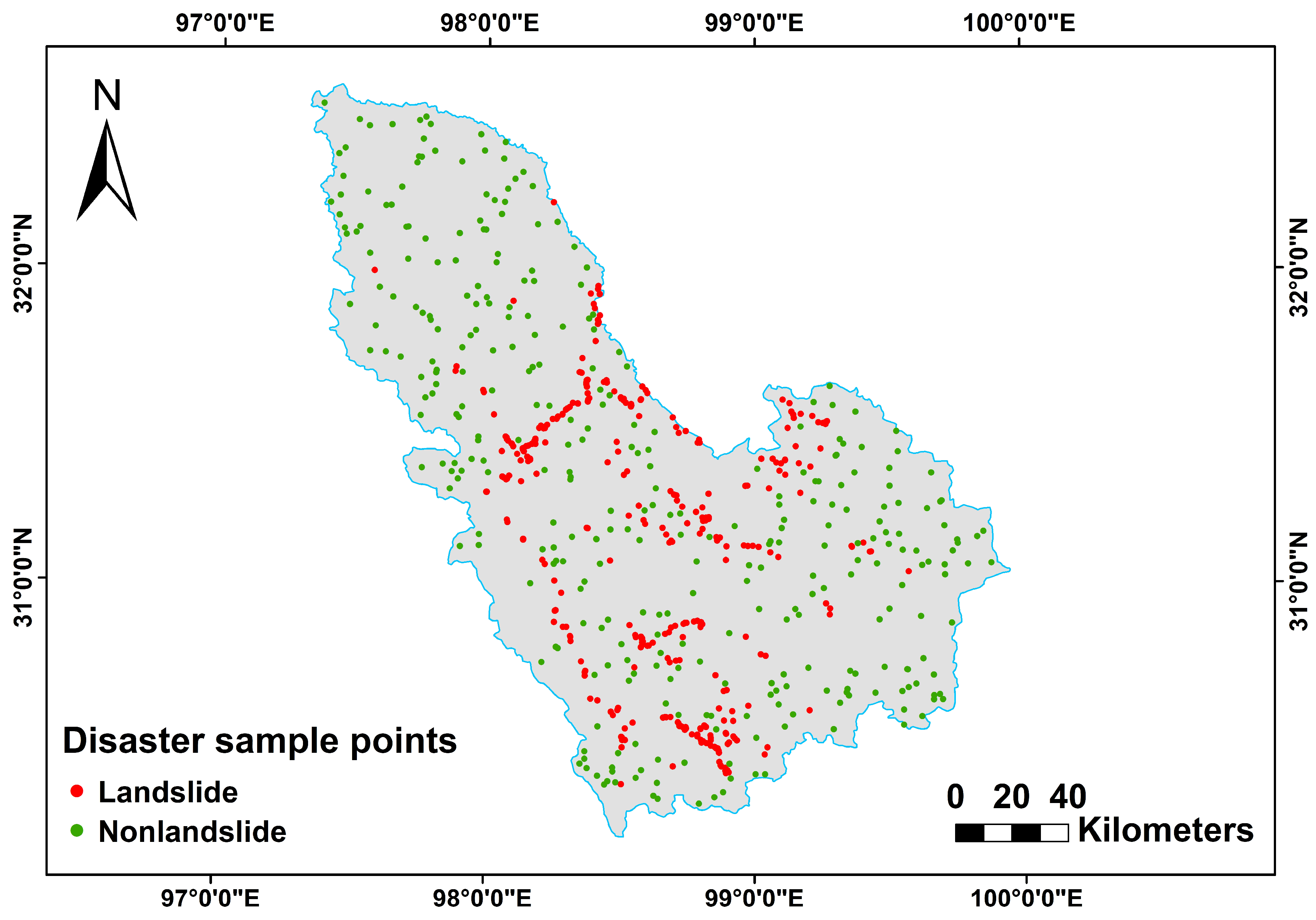
2.2. Research Data
3. Landslide Susceptibility Prediction Based on BGA-Net
3.1. Basic Framework of Landslide Susceptibility Prediction (LSP) Model Based on CNN
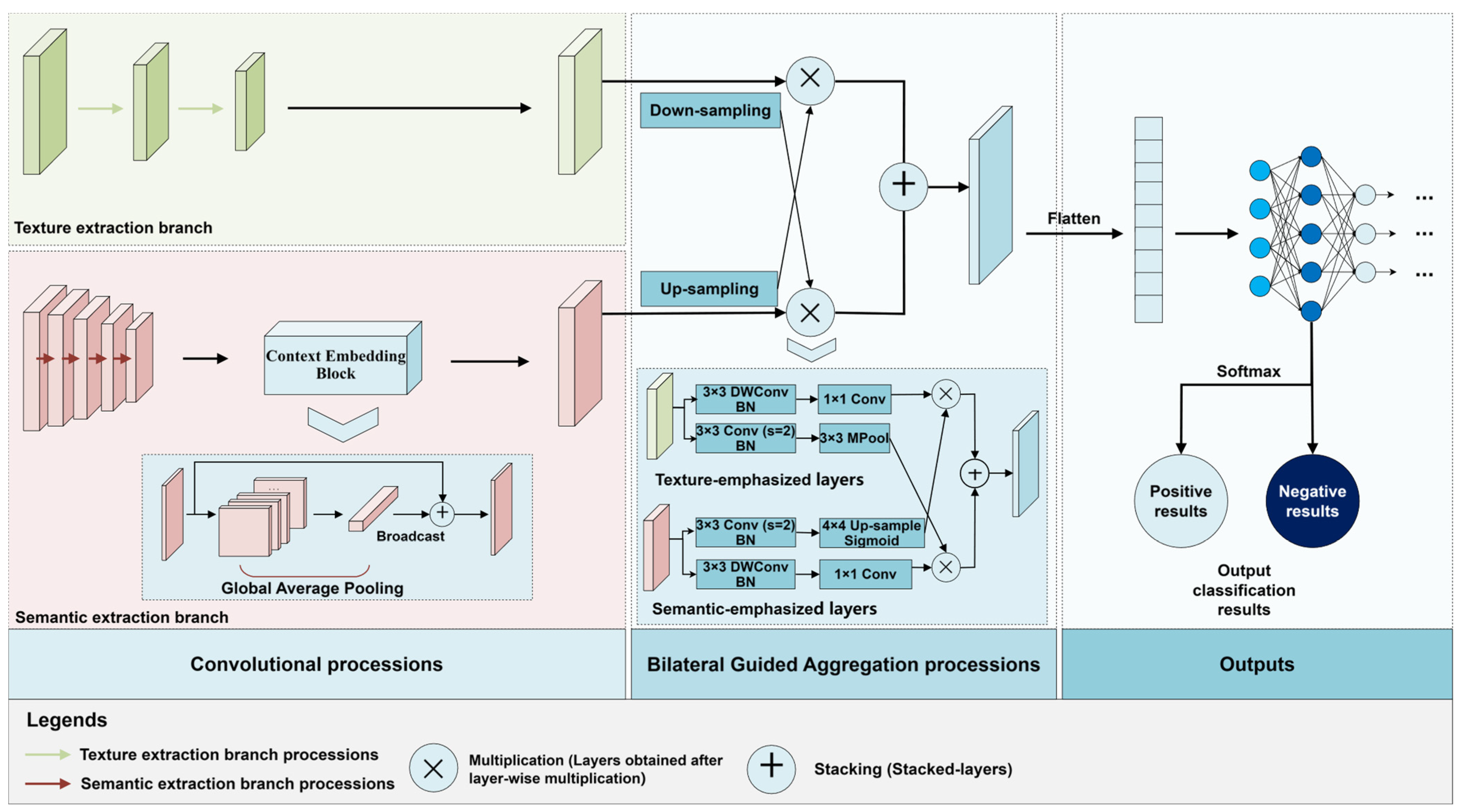
3.1.1. BGA-Net Network Structure
3.1.2. Context Embedding Block (CEB)
3.1.3. Bilateral Guided Aggregation (BGA)
3.2. Validation
3.3. Deformation Monitoring Based on SBAS-InSAR
4. Landslide Hazard Analysis Using Joint SBAS-InSAR Technology
4.1. Model Building and Training
4.1.1. Model Building
4.1.2. Model Training
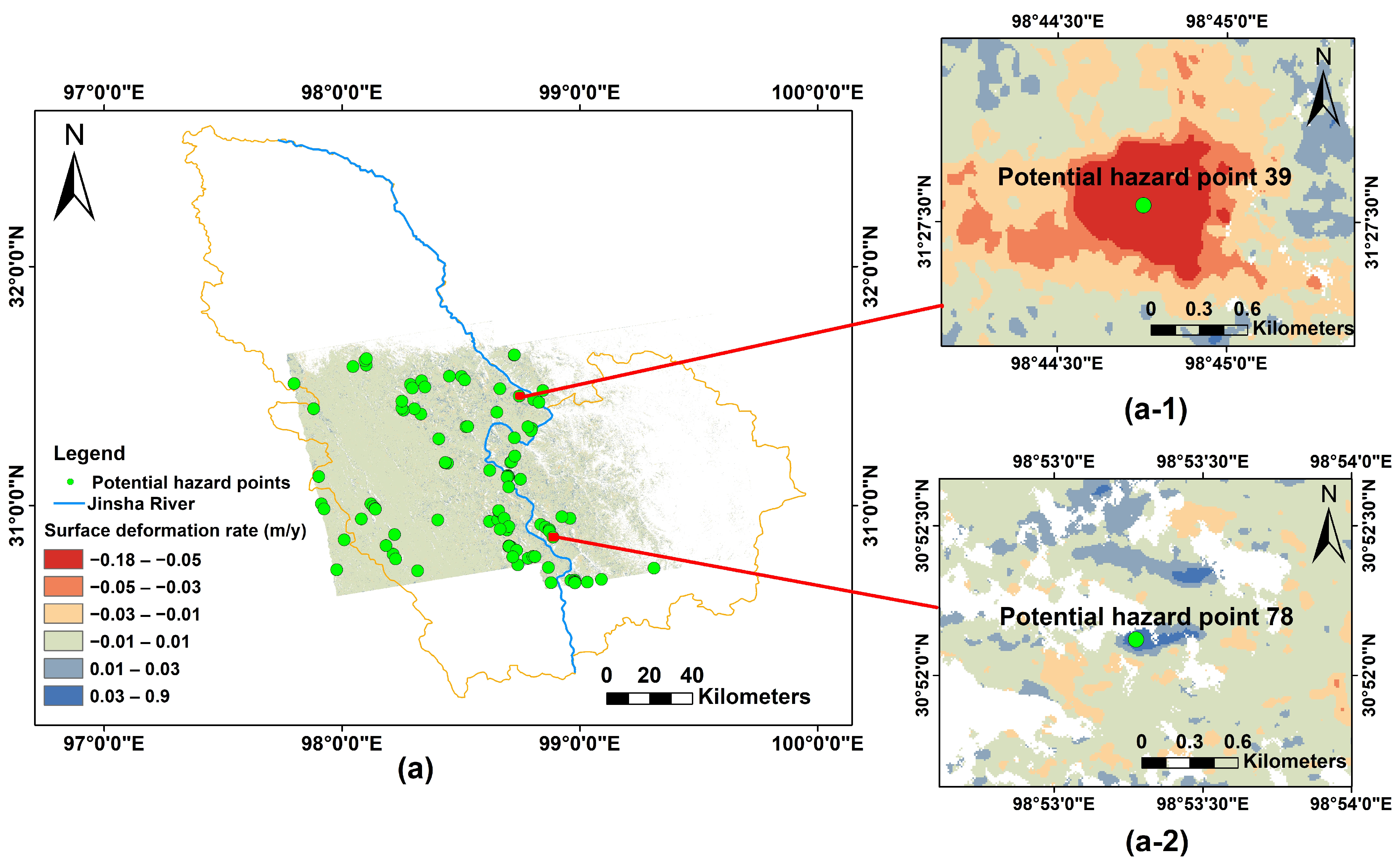
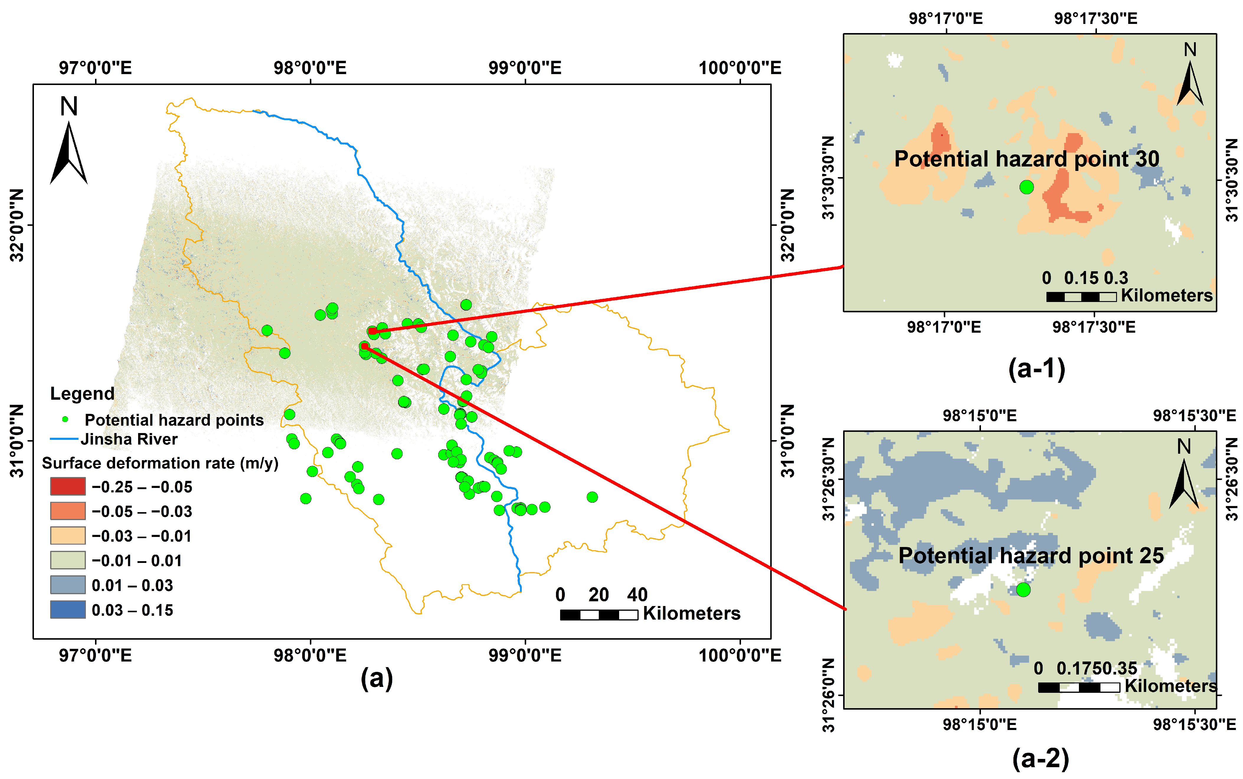
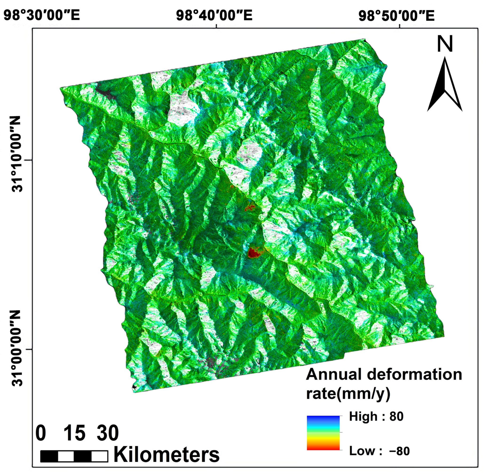
4.2. Satellite-Borne SBAS-InSAR Surface Deformation Monitoring
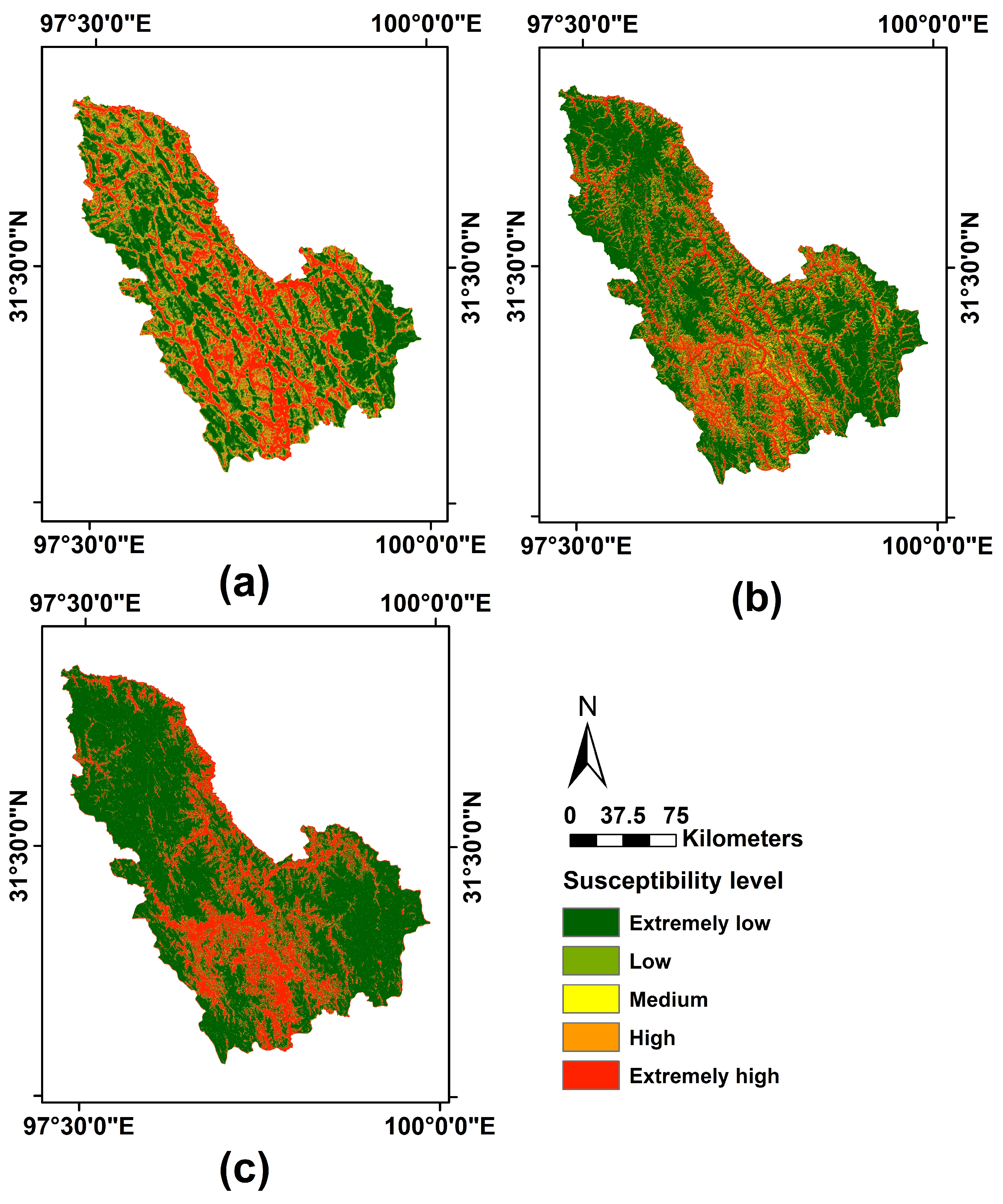
4.3. Results of Landslide Susceptibility Prediction (LSP)
4.4. Joint Risk Assessment Based on Landslide Susceptibility and Surface Deformation
5. Discussion
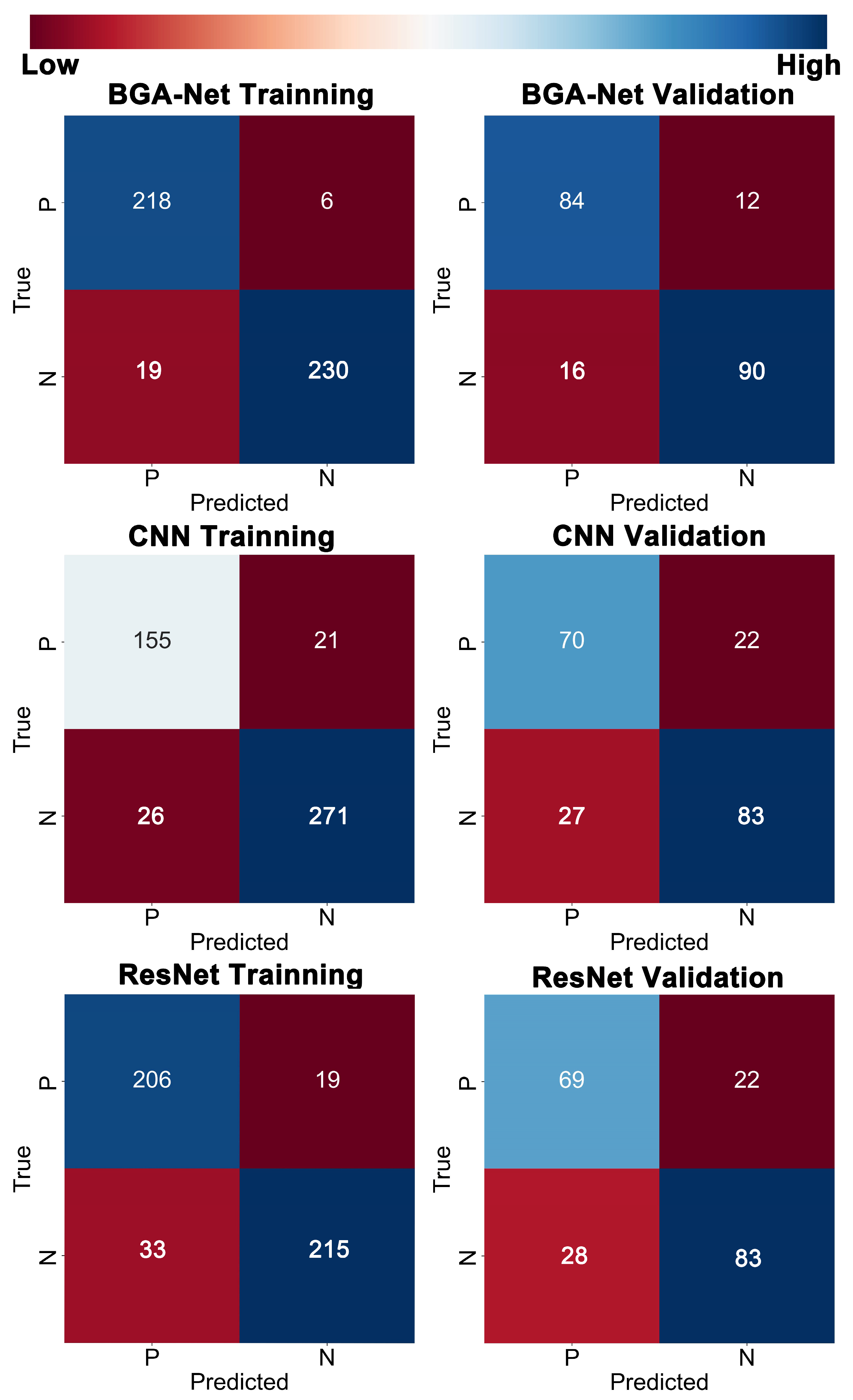
5.1. Accuracy and Superiority of BGA-Net for LSP
5.2. Eeffectiveness of Landslide Risk Assessment Jointly Based on LSP and SBAS-InSAR
5.3. Deformation and High-Risk Zonation-Forming Mechanism Inference
6. Conclusions
Author Contributions
Funding
Data Availability Statement
Conflicts of Interest
References
- Wang, X.F.; Metcalfe, I.; Jian, P.; He, L.Q.; Wang, C.S. The Jinshajiang-Ailaoshan Suture Zone, China: Tectonostratigraphy, age and evolution. J. Asian Earth Sci. 2000, 18, 675–690. [Google Scholar] [CrossRef]
- Pourghasemi, H.R.; Kerle, N. Random forests and evidential belief function-based landslide susceptibility assessment in Western Mazandaran Province, Iran. Environ. Earth Sci. 2016, 75. [Google Scholar] [CrossRef]
- Xu, C.; Dai, F.C.; Xu, X.W.; Lee, Y.H. GIS-based support vector machine modeling of earthquake-triggered landslide susceptibility in the Jianjiang River watershed, China. Geomorphology 2012, 145, 70–80. [Google Scholar] [CrossRef]
- Lee, S.; Hong, S.M.; Jung, H.S. A Support Vector Machine for Landslide Susceptibility Mapping in Gangwon Province, Korea. Sustainability 2017, 9, 48. [Google Scholar] [CrossRef]
- Varnes, D.J. Landslide Hazard Zonation: A Review of Principles and Practice; Natural Hazards; United Nations: Paris, France, 1984. [Google Scholar]
- Peng, H.; Zhaocheng, G.; Chunling, L.; Jienan, T.; Shanshan, W.; Jiemin, X. Evaluation Research on the Landslide Disaster Liability in Zha Da Region of Tibet. Sci. Technol. Eng. 2016, 16, 193–200. [Google Scholar]
- Wang, Y.; Wen, H.J.; Sun, D.L.; Li, Y.C. Quantitative Assessment of Landslide Risk Based on Susceptibility Mapping Using Random Forest and GeoDetector. Remote Sens. 2021, 13, 2625. [Google Scholar] [CrossRef]
- Zhang, K.X.; Wu, X.L.; Niu, R.Q.; Yang, K.; Zhao, L.R. The assessment of landslide susceptibility mapping using random forest and decision tree methods in the Three Gorges Reservoir area, China. Environ. Earth Sci. 2017, 76, 405. [Google Scholar] [CrossRef]
- Arabameri, A.; Pradhan, B.; Rezaei, K.; Yamani, M.; Pourghasemi, H.R.; Lombardo, L. Spatial modelling of gully erosion using evidential belief function, logistic regression, and a new ensemble of evidential belief function–logistic regression algorithm. Land Degrad. Dev. 2018, 29, 4035–4049. [Google Scholar] [CrossRef]
- Tsangaratos, P.; Ilia, I. Comparison of a logistic regression and Naïve Bayes classifier in landslide susceptibility assessments: The influence of models complexity and training dataset size. CATENA 2016, 145, 164–179. [Google Scholar] [CrossRef]
- Xiong, J.; Zhu, J.; Su, P.; Gong, Y.; Zhao, Y.; Li, J.; Li, W. Risk Assessment of Landslide in the Xiluodu Reservoir Area Based on GIS and Information Value Method. Resour. Environ. Yangtze Basin 2019, 28, 700–711. [Google Scholar]
- Kangping, S.I.; Yuan, T.; Daming, W.; Lun, W.U.; Yalin, Z.H.U. Comparison of Three Statistical Methods on Landslide Susceptibility Analysis: A Case Study of Shenzhen City. Acta Sci. Nat. Univ. Pekin. 2009, 45, 639–646. [Google Scholar]
- Niu, R.; Wu, X.; Yao, D.; Peng, L.; Ai, L.; Peng, J. Susceptibility Assessment of Landslides Triggered by the Lushan Earthquake, April 20, 2013, China. IEEE J. Sel. Top. Appl. Earth Obs. Remote Sens. 2014, 7, 3979–3992. [Google Scholar] [CrossRef]
- Wu, X.L.; Chen, X.Y.; Zhan, F.B.; Hong, S. Global research trends in landslides during 1991–2014: A bibliometric analysis. Landslides 2015, 12, 1215–1226. [Google Scholar] [CrossRef]
- Wu, X.L.; Ren, F.; Niu, R.Q. Landslide susceptibility assessment using object mapping units, decision tree, and support vector machine models in the Three Gorges of China. Environ. Earth Sci. 2014, 71, 4725–4738. [Google Scholar] [CrossRef]
- Pham, M.-V.; Kim, Y.-T. Debris flow detection and velocity estimation using deep convolutional neural network and image processing. Landslides 2022, 19, 2473–2488. [Google Scholar] [CrossRef]
- Li, H.; Hu, B.X.; Lin, B.; Zhu, S.; Meng, F.; Li, Y. Collapse Susceptibility Assessment in Taihe Town Based on Convolutional Neural Network and Information Value Method. Water 2024, 16, 709. [Google Scholar] [CrossRef]
- Chen, Y.Y.; Ming, D.P.; Yu, J.C.; Xu, L.; Ma, Y.N.; Li, Y.; Ling, X.; Zhu, Y.Q. Susceptibility-Guided Landslide Detection Using Fully Convolutional Neural Network. IEEE J. Sel. Top. Appl. Earth Obs. Remote Sens. 2023, 16, 998–1018. [Google Scholar] [CrossRef]
- Li, Y.; Ming, D.; Zhang, L.; Niu, Y.; Chen, Y. Seismic Landslide Susceptibility Assessment Using Newmark Displacement Based on a Dual-Channel Convolutional Neural Network. Remote Sens. 2024, 16, 566. [Google Scholar] [CrossRef]
- Chen, J.; Cui, Z.; Chen, R.; Zheng, X. The origin and evolution of the Temi paleolandslide-dammed lake in the upper Jinsha River. Earth Sci. Front. 2021, 28, 85–93. [Google Scholar]
- Fan, X.M.; Xu, Q.; Alonso-Rodriguez, A.; Subramanian, S.S.; Li, W.L.; Zheng, G.; Dong, X.J.; Huang, R.Q. Successive landsliding and damming of the Jinsha River in eastern Tibet, China: Prime investigation, early warning, and emergency response. Landslides 2019, 16, 1003–1020. [Google Scholar] [CrossRef]
- Ling, X.; Zhu, Y.Q.; Ming, D.P.; Chen, Y.Y.; Zhang, L.; Du, T.Y. Feature Engineering of Geohazard Susceptibility Analysis Based on the Random Forest Algorithm: Taking Tianshui City, Gansu Province, as an Example. Remote Sens. 2022, 14, 5658. [Google Scholar] [CrossRef]
- Zhang, Y.; Chen, Y.Y.; Ming, D.P.; Zhu, Y.Q.; Ling, X.; Zhang, X.Y.; Lian, X.Y. Landslide hazard analysis based on SBAS-InSAR and MCE-CNN model: A case study of Kongtong, Pingliang. Geocarto Int. 2022, 38, 1–22. [Google Scholar] [CrossRef]
- Tien Bui, D.; Tuan, T.A.; Klempe, H.; Pradhan, B.; Revhaug, I. Spatial prediction models for shallow landslide hazards: A comparative assessment of the efficacy of support vector machines, artificial neural networks, kernel logistic regression, and logistic model tree. Landslides 2016, 13, 361–378. [Google Scholar] [CrossRef]
- Zhou, H.; Dai, K.R.; Pirasteh, S.; Li, R.P.; Xiang, J.M.; Li, Z.H. InSAR Spatial-Heterogeneity Tropospheric Delay Correction in Steep Mountainous Areas Based on Deep Learning for Landslides Monitoring. IEEE Trans. Geosci. Remote Sens. 2023, 61, 5215014. [Google Scholar] [CrossRef]
- Deng, J.; Dai, K.R.; Liang, R.B.; Chen, L.C.; Wen, N.L.; Zheng, G.; Xu, H. Interferometric Synthetic Aperture Radar Applicability Analysis for Potential Landslide Identification in Steep Mountainous Areas with C/L Band Data. Remote Sens. 2023, 15, 4538. [Google Scholar] [CrossRef]
- Dai, K.R.; Li, Z.Y.; Xu, Q.; Tomas, R.; Li, T.; Jiang, L.M.; Zhang, J.Y.; Yin, T.; Wang, H. Identification and evaluation of the high mountain upper slope potential landslide based on multi-source remote sensing: The Aniangzhai landslide case study. Landslides 2023, 20, 1405–1417. [Google Scholar] [CrossRef]
- Berardino, P.; Fornaro, G.; Lanari, R.; Sansosti, E. A new algorithm for surface deformation monitoring based on small baseline differential SAR interferograms. IEEE Trans. Geosci. Remote Sens. 2002, 40, 2375–2383. [Google Scholar] [CrossRef]
- Zhou, H.; Dai, K.R.; Tang, X.C.; Xiang, J.M.; Li, R.P.; Wu, M.T.; Peng, Y.R.; Li, Z.H. Time-Series InSAR with Deep-Learning-Based Topography-Dependent Atmospheric Delay Correction for Potential Landslide Detection. Remote Sens. 2023, 15, 5287. [Google Scholar] [CrossRef]
- Dai, K.R.; Deng, J.; Xu, Q.; Li, Z.H.; Shi, X.L.; Hancock, C.; Wen, N.L.; Zhang, L.L.; Zhuo, G.C. Interpretation and sensitivity analysis of the InSAR line of sight displacements in landslide measurements. Giscience Remote Sens. 2022, 59, 1226–1242. [Google Scholar] [CrossRef]
- Guo, S.; Zhang, W.; Kang, W.; Zhang, T.; Li, Y. The Study on Land Subsidence in Kunming by Integrating PS, SBAS and DS InSAR. Remote Sens. Technol. Appl. 2022, 37, 460–473. [Google Scholar]
- Chen, Y.Y.; Ming, D.P.; Ling, X.; Lv, X.W.; Zhou, C.H. Landslide Susceptibility Mapping Using Feature Fusion-Based CPCNN-ML in Lantau Island, Hong Kong. IEEE J. Sel. Top. Appl. Earth Obs. Remote Sens. 2021, 14, 3625–3639. [Google Scholar] [CrossRef]
- Dai, C.; Li, W.L.; Lu, H.Y.; Zhang, S. Landslide Hazard Assessment Method Considering the Deformation Factor: A Case Study of Zhouqu, Gansu Province, Northwest China. Remote Sens. 2023, 15, 596. [Google Scholar] [CrossRef]






| Slide Name | Time | Triggering Factor | Impact |
|---|---|---|---|
| Temi ancient landslide | about 1.4 ka BP | Earthquake-triggered | Barrier lakes formed; the terrain changed |
| Laojuntan landslide | 1965 | Rainfall-triggered | Significant loss of life and property |
| Baige landslide | 2018 | Gravity-triggered | Direct losses of about CNY 153 million; serious consequences, resulting in multiple deaths and injuries |
| Index | Data Source | Data Type | Data Usage |
|---|---|---|---|
| 1 | Sentinel-1A satellite data | Radar data | Large-scale surface deformation monitoring |
| 2 | Field geological survey data | Geological survey textual and image records | Analyze landslide and slope development and disaster mechanisms |
| 3 | High-Resolution Gaofen-2 data | Optical remote sensing image data | Analyze surface characteristics and extract disaster-bearing bodies in hazardous areas |
| 4 | SRTM DEM | DEM | Assist with Sentinel-1A satellite data preprocessing; extract hazard factors: elevation, slope, aspect, curvature, TWI, and TRI |
| 5 | Road vector | Vector data | Extract typical disaster-bearing bodies; extract hazard factor: distance to road |
| 6 | River vector | Vector data | Extract hazard factor: distance to river |
| 7 | Fault vector | Vector data | Extract hazard factors: distance to fault and fault distribution density |
| 8 | CHIRSP Pentad data | Meteorological satellite inversion data | Extract hazard factor: annual average precipitation |
| 9 | Global 30 m resolution land use type data | Land use type classification data | Extract hazard factor: land use type |
| 10 | Landsat 8 OTL satellite data | NDVI | Extract hazard factor: NDVI |
| Surface Deformation Hazard | Extremely Low | Low | Moderate | High | Extremely High | |
|---|---|---|---|---|---|---|
| LSP | ||||||
| Extremely Low | Extremely Low | Extremely Low | Low | Moderate | High | |
| Low | Extremely Low | Low | Moderate | Moderate | High | |
| Moderate | Low | Low | Moderate | High | Extremely High | |
| High | Moderate | Moderate | High | High | Extremely High | |
| Extremely High | High | High | High | Extremely High | Extremely High | |
| Model | High | Extremely High | Ratio (%) |
|---|---|---|---|
| BGA-Net | 10 | 312 | 95.27 |
| CNN | 2 | 305 | 90.83 |
| ResNet | 17 | 253 | 79.88 |
| Model | Dataset Type | OA | Precision | Recall | F1-Score | AUC |
|---|---|---|---|---|---|---|
| BGA-Net | Training set | 0.946 | 0.971 | 0.92 | 0.945 | 0.923 |
| Validation set | 0.855 | 0.870 | 0.835 | 0.852 | 0.856 | |
| CNN | Training set | 0.897 | 0.877 | 0.852 | 0.897 | 0.898 |
| Validation set | 0.749 | 0.755 | 0.717 | 0.736 | 0.748 | |
| Res-Net | Training set | 0.888 | 0.912 | 0.862 | 0.886 | 0.888 |
| Validation set | 0.744 | 0.753 | 0.707 | 0.729 | 0.743 |
Disclaimer/Publisher’s Note: The statements, opinions and data contained in all publications are solely those of the individual author(s) and contributor(s) and not of MDPI and/or the editor(s). MDPI and/or the editor(s) disclaim responsibility for any injury to people or property resulting from any ideas, methods, instructions or products referred to in the content. |
© 2024 by the authors. Licensee MDPI, Basel, Switzerland. This article is an open access article distributed under the terms and conditions of the Creative Commons Attribution (CC BY) license (https://creativecommons.org/licenses/by/4.0/).
Share and Cite
Su, L.; Zhang, L.; Gui, Y.; Li, Y.; Zhang, Z.; Xu, L.; Ming, D. Landslide Hazard Analysis Combining BGA-Net-Based Landslide Susceptibility Perception and Small Baseline Subset Interferometric Synthetic Aperture Radar in the Baige Section in the Upper Reaches of Jinsha River. Remote Sens. 2024, 16, 2125. https://doi.org/10.3390/rs16122125
Su L, Zhang L, Gui Y, Li Y, Zhang Z, Xu L, Ming D. Landslide Hazard Analysis Combining BGA-Net-Based Landslide Susceptibility Perception and Small Baseline Subset Interferometric Synthetic Aperture Radar in the Baige Section in the Upper Reaches of Jinsha River. Remote Sensing. 2024; 16(12):2125. https://doi.org/10.3390/rs16122125
Chicago/Turabian StyleSu, Leyi, Liang Zhang, Yuannan Gui, Yan Li, Zhi Zhang, Lu Xu, and Dongping Ming. 2024. "Landslide Hazard Analysis Combining BGA-Net-Based Landslide Susceptibility Perception and Small Baseline Subset Interferometric Synthetic Aperture Radar in the Baige Section in the Upper Reaches of Jinsha River" Remote Sensing 16, no. 12: 2125. https://doi.org/10.3390/rs16122125
APA StyleSu, L., Zhang, L., Gui, Y., Li, Y., Zhang, Z., Xu, L., & Ming, D. (2024). Landslide Hazard Analysis Combining BGA-Net-Based Landslide Susceptibility Perception and Small Baseline Subset Interferometric Synthetic Aperture Radar in the Baige Section in the Upper Reaches of Jinsha River. Remote Sensing, 16(12), 2125. https://doi.org/10.3390/rs16122125


