Abstract
During the summer, substantial freshwater discharge from the Changjiang River into the East China Sea (ECS) results in extensive low-salinity water (LSW) plumes that significantly affect regions along the southern Korean Peninsula and near Jeju Island. Previous research developed an empirical equation to estimate sea surface salinity (SSS) in the ECS during the summer season using remote-sensing reflectance (Rrs) data from bands 3–6 (490, 555, 660, and 680 nm) of the Geostationary Ocean Color Imager (GOCI). With the conclusion of the GOCI mission in March 2021, this study aims to ensure the continuity of SSS estimation in the ECS by transitioning to its successor, the GOCI-II. This transition was facilitated through two approaches: applying the existing GOCI-based equation and introducing a new machine learning method using a random forest model. Our analysis demonstrated a high correlation between SSS estimates derived from the GOCI and GOCI-II when applying the equation developed for the GOCI to both satellites, as indicated by a robust R2 value of 0.984 and a low RMSD of 0.8465 psu. This study successfully addressed the challenge of maintaining continuous SSS estimation in the ECS post-GOCI mission and evaluated the accuracy and limitations of the GOCI-II-derived SSS, proposing future strategies to enhance its effectiveness.
1. Introduction
A significant volume of freshwater flows into the East China Sea (ECS) from the Changjiang River, also known as the Yangtze River, generating low-salinity water (LSW) plumes recognized as Changjiang diluted water (CDW) [1]. This CDW plays a pivotal role in stratifying the surface layer, leading to a shallower mixed layer [2]. Such stratification enhances sea surface temperature (SST) by obstructing heat exchange, thereby forming a barrier layer between the mixed and deeper ocean layers [2,3]. CDW discharge exhibits seasonal fluctuations, with a peak during the summer [4]. During the summer monsoon, a significant amount of CDW, marked by low salinity and high temperature, spreads northeastward, driven by both wind and ocean currents, affecting areas up to Jeju Island and the Korean Strait [5,6,7]. Considering LSW’s impact on the marine ecosystem and the substantial harm it causes to fish farms in southern Korea [8,9,10], monitoring sea surface salinity (SSS) is deemed essential for coastal fisheries management. However, relying solely on in situ data (ocean research centers and buoy systems) for determining LSW plume distribution faces challenges.
L-band (1.4 GHz) microwave radiometers have played a pivotal role in global SSS observation, overcoming the limitations of spatiotemporal resolution found in in situ data [11,12]. Beginning with the European Space Agency (ESA)’s Soil Moisture and Ocean Salinity (SMOS) mission in 2009, the National Aeronautics and Space Administration (NASA) launched Aquarius in 2011 and the Soil Moisture Active Passive (SMAP) in 2015. Yet their long revisit times (≥3 days) hinder the ability to provide daily, comprehensive global ocean SSS coverage [11,12]. While SMOS and SMAP provide globally averaged level 3 (L3) data by compiling SSS data over 8 days, this aggregation falls short of capturing the rapidly evolving LSW plumes. Moreover, the accuracy of the L-band microwave radiometer-retrieved SSS is affected by radio frequency interference and land–sea contamination, particularly in coastal regions [11]. As a result, while these instruments can offer SSS products, they inherently mask coastal regions. Additionally, their relatively low spatial resolution, ranging from 25 to 100 km, hinders the detailed analysis of SSS patterns in the ECS.
To overcome these limitations, numerous studies have explored the potential of ocean color reflectance and related ocean products for detailed SSS pattern estimation within LSW plumes and coastal regions [13]. Despite cloud interference, ocean color-derived SSS estimations have proven more effective than L-band microwave radiometer-derived SSS estimations, especially for coastal monitoring [8]. Globally, regions heavily influenced by LSW, such as the Gulf of Mexico, the Arabian Gulf, the ECS, and the Bohai Sea, have seen SSS estimation through regional algorithms utilizing data from instruments like the Landsat-8 Operational Land Imager (OLI), the Moderate Resolution Imaging Spectroradiometer (MODIS), the Visible Infrared Imaging Radiometer Suite (VIIRS), and the Sea-viewing Wide Field-of-view Sensor (SeaWiFS) [14,15,16,17,18]. Differing from L-band microwave radiometry, ocean color or optical sensor-based SSS estimation does not depend on direct ocean color signals but rather on indirect signals, notably the correlation between colored dissolved organic matter (CDOM) and salinity [13]. In coastal areas, the riverine discharge of various organic materials results in areas with diminished salinity and heightened CDOM concentrations; these substances influence the ocean’s color and, by extension, are detectable as satellite-based ocean color signals [19]. Moreover, SSS estimations incorporate empirical correlations between the SSS and a range of parameters, including ocean color reflectance, SST, wind speed, and CDOM. While traditional approaches have relied on empirical equations [1,20,21,22,23], the advent of machine learning approaches capable of handling complex inter-variable relationships heralds a new era in SSS estimation [10,14,18,24,25,26,27].
The SSS in the East Asian seas is monitored using the Geostationary Ocean Color Imager (GOCI), the world’s first geostationary ocean color sensor [8,9,10,19,24,25]. The GOCI stands out for its efficiency over polar orbiting satellites in tracking rapid LSW changes within the ECS due to its superior spatiotemporal resolution (500 m and eight observations per day; details further in Section 2.1). A prior study [8] assessed the GOCI’s utility in estimating the summer SSS in the ECS for monitoring the LSW plume. It developed an empirical multilinear regression equation targeting in situ SSS data with the remote-sensing reflectance (Rrs) from GOCI bands 3–6 (detailed in Section 3). This equation demonstrated a high correlation with the in situ data, allowing for the detailed hourly monitoring of the SSS distribution within the ECS using the GOCI-derived SSS. With the conclusion of the GOCI’s mission in March 2021, the potential for continued SSS estimation in the ECS using its successor, GOCI-II, necessitates evaluation. This continuous monitoring through the GOCI-II, succeeding the GOCI, could enable long-term monitoring and predictions of SSS in the ESC with data accumulated over more than a decade.
Therefore, this study aimed to evaluate the ongoing application of the GOCI-II-derived SSS within the ECS, identifying its limitations and potential enhancements. Confirming the continuity between GOCI- and GOCI-II-derived SSS estimations involved applying the empirical equation developed in previous research [8] to the GOCI-II. Moreover, leveraging in situ data from the preceding study [8], a novel machine learning model for SSS estimation based on GOCI data was developed and adjusted for application to the GOCI-II. The outcomes from this new machine learning model were compared against the previously developed empirical equation. In this study, we (1) utilized the GOCI-derived equation and the novel machine learning model after calibrating the GOCI-II Rrs to match the GOCI Rrs, (2) assessed the correlation between SSS estimates from both the GOCI and the GOCI-II, (3) validated the new SSS estimation from the GOCI-II against in situ data and SMAP SSS products, and (4) pinpointed both the constraints and avenues for future refinement of the GOCI-II-derived SSS estimations.
2. Data
2.1. Geostationary Ocean Color Imager (GOCI)-II
The GOCI-II, the successor to the GOCI mission, was launched aboard the Geo-Korea Multi-Purpose SATellite (KOMPSAT) 2B in February 2020 [28]. Similar to the GOCI, it covers over a 2500 km × 2500 km area, encapsulating the Korean Peninsula, East China, and Japan. The GOCI-II introduces improvements in both spatial resolution and spectral band capabilities compared to the GOCI (Table 1). Specifically, the GOCI-II has an improved spatial resolution of 250 m and incorporates 12 bands, covering visible and near-infrared wavelengths (380, 412, 443, 490, 510, 555, 620, 660, 680, 709, 745, and 865 nm), including a wide band dedicated to geometric correction. The addition of four new bands (380, 510, 620, and 709 nm) enhances the precision of atmospheric corrections and the quality of ocean products [29]. Additionally, the GOCI-II conducts observations up to 10 times daily and introduces a new full disk observation mode that spans 12,800 km × 12,800 km from Eastern Russia to Australia and Antarctica. A GOCI-II local area consists of 4-by-3 sub-images (called slots) and is obtained using the step-and-stare method. This study utilized two specific slots (slots 7 and 10) from the 12 local mode slots available in the daily 03 UTC images, focusing on data from August 2020 to 2022. The spectral bands in the GOCI-II data corresponding to 490, 555, 660, and 680 nm (bands 4, 6, 8, and 9), which align with those used for estimating the GOCI-derived SSS, facilitated the estimation of the GOCI-II-derived SSS. Various data flags identifying conditions such as clouds or ice, land, failed atmospheric correction, high solar zenith angle and view zenith angle, out-of-range multiple-scattering epsilon, and cloud edge were applied to filter the GOCI-II satellite data [30]. Notably, the GOCI-II Rrs data used in this study have been further processed beyond the publicly available data from the Korea Hydrographic and Oceanographic Agency (KHOA), incorporating hourly reanalysis of meteorological data and adjusted vicarious gains for atmospheric correction, following the approach presented in [31].

Table 1.
GOCI and GOCI-II specifications.
2.2. In Situ Data
For validation purposes, we utilized two types of in situ data. The first dataset included observations from the Ieodo Ocean Research Station (I-ORS), managed by the KHOA. This data was accessed through the Ocean Data in Grid Framework website [32]. Located at 32.12°N and 125.18°S, the I-ORS is ideally positioned in the path of LSW plumes originating from the Changjiang River and flowing towards the southern region of the Korean Peninsula, as illustrated by the green circle in the Figure 1. Salinity measurements were taken at depths of 5, 20, and 40 m, recorded every minute using a conductivity, temperature, and depth (CTD) sensor [33]. Additionally, we used serial oceanographic observation data from the National Institute of Fisheries Sciences (NIFS), available via the Korea Oceanographic Data Center website [34]. This second dataset comprises observations from various designated points around the Korean Peninsula, collected six times a year (February, April, June, August, October, and December) through ship-based measurements, providing a broader validation area than the singular stationary position of the I-ORS, as shown in Figure 1. We utilized in situ data from August 2020 and 2021 for both datasets.
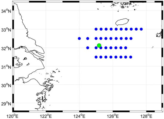
Figure 1.
The East China Sea (ECS) study area and the in situ data collection sites used in this study. The green circle represents the Ieodo Ocean Research Station’s location (32.12°N and 125.18°S), and the blue circles depict the distribution of serial oceanographic observation data collected in August 2020 and 2021.
2.3. SMAP SSS
We included a comparison of the spatial distribution of the GOCI-II-derived SSS with the SMAP level 2B (L2B) and L3 data (version 5) provided by the Jet Propulsion Laboratory. The SMAP SSS dataset, available since April 2015, is produced using a combined active–passive retrieval algorithm [35] and offers global coverage within a 25 km grid, featuring an approximate spatial resolution of 60 km. While SMAP L2B data are compiled daily and organized along a track, the full global ocean coverage is constrained by the satellite’s long revisit time (≥3 days). The L3 8-day running mean SSS products are generated by interpolating L2B data for ±3.5 days surrounding the target date, applying Gaussian weighting to ensure continuity and coverage [36,37].
3. Methodology
Our approach incorporated the application of an established equation for deriving the SSS from the GOCI data, as detailed in previous research [8] (hereafter, Choi’s equation), alongside a machine learning model. This process was to ensure that the Rrs data from the GOCI-II was compatible with that of the GOCI. We then evaluated the correlation between the SSS estimates obtained from the GOCI and those derived from the GOCI-II (Figure 2). Through this methodology, we identified two distinct SSS estimations from the GOCI-II:
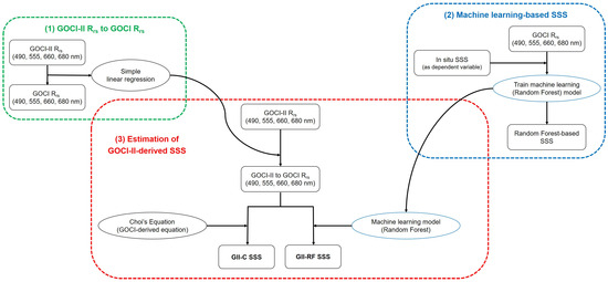
Figure 2.
Flow chart for the procedural steps for estimating the SSS from GOCI-II data. Choi’s equation is represented as a multilinear regression equation used to estimate the SSS in the ECS using GOCI data, as explained in Section 3.2. ‘GII-C SSS’ is the SSS derived from GOCI-II using Choi’s equation, whereas ‘GII-RF SSS’ indicates the SSS derived from GOCI-II using the machine learning model.
- GOCI-II-derived SSS using Choi’s equation, subsequently referred to as ‘GII-C SSS’.
- GOCI-II-derived SSS using the machine learning model, subsequently referred to as ‘GII-RF SSS’.
To validate the accuracy of both the GII-C SSS and the GII-RF SSS, we compared these estimates with in situ data and SMAP SSS products, assessing their reliability and precision.
3.1. Adjustment of GOCI-II Rrs to Align with GOCI Rrs
To address the differences in spatial resolution between the GOCI (500 m) and GOCI-II data (250 m) (Table 1), we downscaled the GOCI-II data to match the spatial resolution of the GOCI data. This process involved performing a simple least squares linear regression on corresponding spectral bands from GOCI-II Rrs to GOCI Rrs using MATLAB R2022b’s ‘polyfit’ function. This regression enabled the conversion of GOCI-II Rrs to be consistent with GOCI Rrs. Given that Choi’s equation was developed using ECS data specifically for August, and considering the period of overlap between the GOCI and GOCI-II from April 2020 to March 2021, the Rrs conversion equations were tailored exclusively for satellite pixels within the ECS (Figure 1) during August 2020. Specific Rrs conversion equations were developed for each relevant band (490, 555, 660, and 680 nm), with the coefficients detailed in Table 2. Notably, except for the 680 nm band, the slope values were below 1, suggesting that the GOCI-II’s Rrs values were generally higher than those of the GOCI. An analysis conducted on the UTC03 image from 22 March 2021, as presented in [38], revealed a pronounced overestimation of GOCI-II Rrs at 660 nm. Despite seasonal differences, this trend of overestimation was consistent with the August 2020 data used in this study. Scatterplots comparing the adjusted GOCI-II Rrs against GOCI Rrs (Figure 3) show a close resemblance across all bands. This comparative analysis indicated an improvement in the coefficient of determination (R2), with a reduction in both the root mean square deviation (RMSD) and relative RMSD (rRMSD) for the adjusted GOCI-II Rrs (Table 2 and Figure 3).

Table 2.
The sample count (N), root mean square difference (RMSD), relative RMSD (rRMSD), and coefficient of determination (R2) for the original GOCI-II Rrs compared to the GOCI Rrs. The conversion from GOCI-II Rrs to GOCI Rrs, essential for alignment, was achieved for each spectral band within the ECS during August 2020. The formula expressing the relationship between the GOCI Rrs and GOCI-II Rrs is expressed as GOCI Rrs = Slope × GOCI-II Rrs + Offset.
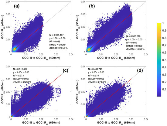
Figure 3.
Scatterplots of the adjusted GOCI-II Rrs versus GOCI Rrs for bands at (a) 443 nm, (b) 555 nm, (c) 660 nm, and (d) 680 nm. The color bar depicts data density on a logarithmic scale, visually depicting the alignment of the GOCI-II Rrs with the GOCI Rrs across the examined spectral bands.
3.2. Methods Employed for Estimating GOCI-II-Derived SSS
Choi’s equation (Equation (1)), a multilinear regression model, was developed empirically using IBM Corp.’s SPSS Statistics 25 software. It is based on 62 in situ data points collected around Jeju Island alongside GOCI Rrs data at wavelengths of 490, 555, 660, and 680 nm (band 3–6) collected during August from 2011 to 2016 [8]. This equation has shown a strong correlation, further validated with an additional set of 21 in situ data points, resulting in an R2 of 0.803 and an RMSE of 0.914 psu. Choi’s equation utilized as follows:
Machine learning approaches have been applied extensively across various domains, including satellite data analysis for SSS estimation [10,14,27,39,40,41]. In this study, we employed a random forest (RF) model, the most widely used tree-based model in machine learning approaches. The RF is constructed based on numerous independent decision trees, where each decision tree comprises multiple nodes iteratively partitioning input variables based on various criteria to predict the target value [42,43]. The RF method conducts internal cross-validation by utilizing unused samples known as out-of-bag (OOB) samples for each individual tree. In regression tasks, such as the one conducted in this study, the values generated by each tree are averaged to produce the final prediction. This study implemented the RF model using Python’s ‘RandomForestRegressor’ package. The model incorporated ten variables, including the four GOCI Rrs parameters used in Choi’s equation (490, 555, 660, and 680 nm) and six ratios between them, to estimate the SSS within the ECS over the summer period. The same in situ data that were instrumental in developing Choi’s equation [8] were also utilized in this study, with 62 data points for model calibration and 21 for validation.
3.3. Validation
Validation of the GOCI-II-derived SSS was conducted using a dual approach. Initially, in situ data, as detailed in Section 2.2, were aligned with satellite images. For I-ORS data, in situ measurements taken between 12:20 and 12:40 local time at a 5 m depth were averaged and matched with GOCI-II pixel data, considering the observation times of GOCI-II slots 7 and 10. Conversely, NIFS data, not collected continuously, were aligned with GOCI-II images based on observations taken ±6 h from 03 UTC, employing a methodology similar to that of [44]. A total of 41 in situ data points were used for validation, including 16 samples from I-ORS data and 25 samples from NIFS data, with salinity values ranging from 24.10 to 33 psu and average of 29.89 psu.
Additionally, GOCI-II-derived SSS estimates were compared against SMAP SSS products to provide a broader evaluation of SSS distribution in the ECS. While in situ data were geographically constrained, primarily to the vicinity of the I-ORS and Jeju Island, as shown in Figure 1, the use of SMAP SSS products allowed for an expanded analysis across the ECS. This comparison encompassed not only the daily L2B along-track data but also the daily L3 8-day running mean data, which have been used as benchmarks in several studies [19,37,41,45]. For the SMAP L2B data, our analysis was restricted to observations made within ±6 h from 03 UTC [44]. The SMAP L3 8-day running mean data, being derived from interpolation, were correlated with GOCI-II images based solely on the date of observation. Addressing the difference in spatial resolution (25 km for SMAP SSS and 250 m for GOCI-II-derived SSS), we applied triangle-based linear interpolation using MATLAB R2022b to downscale the GOCI-II-derived SSS, thereby ensuring compatibility with the SMAP SSS products.
4. Results of GOCI-II-Derived SSS
Figure 4 presents the comparison of SSS estimates using Choi’s equation, where the SSS derived from adjusted GOCI-II Rrs data (Figure 4a,c) correlated more strongly with that GOCI-derived SSS than the SSS calculated using the original GOCI-II Rrs data (Figure 4b,d). Typically, both the GOCI and GOCI-II apply the same atmospheric correction method [46]. However, the GOCI-II has incorporated the use of additional bands at 620 and 709 nm specifically to improve Rrs estimates in waters with high turbidity [31,38]. Due to the different atmospheric correction methods for turbid waters between the GOCI and GOCI-II, pixels flagged as turbid by the GOCI-II were excluded from this analysis, as shown in Figure 4c,d. It is notable that many pixels with significant deviations were identified as turbid. When excluding these turbid pixels, the GII-C SSS calculated with adjusted GOCI-II Rrs data achieved an RMSD of 0.6993 psu and an rRMSD of 2.49%. Including all pixels, turbid pixels included, the GII-C SSS exhibited an RMSD of 0.8465 psu and an rRMSD of 3.46%. This indicates a more significant correlation between the GII-C SSS and GOCI-derived SSS when excluding turbid pixels. The successful application of Choi’s GOCI-based equation to the adjusted GOCI-II Rrs, which showed strong correlation with the GOCI-derived SSS, suggests a seamless continuity in the GII-C SSS in relation to the GOCI-derived SSS. Figure 5 illustrates scatterplots between in situ data and the SSS estimates derived using GOCI Rrs data through the RF model. For the calibration dataset, the RF model demonstrated an R2 of 0.985 and an RMSD of 0.1807 psu (Figure 5a). However, for the validation dataset, the model exhibited a lower R2 of 0.710 and a higher RMSD of 0.9988 psu (Figure 5b). This variance can be attributed to the relatively small sample size used for training the RF model, leading to diminished accuracy in the validation results compared to the calibration results. When compared with the findings from a prior study that employed an artificial neural network model with GOCI data for SSS estimation [19], the validation result of the RF model in this study are deemed satisfactory.
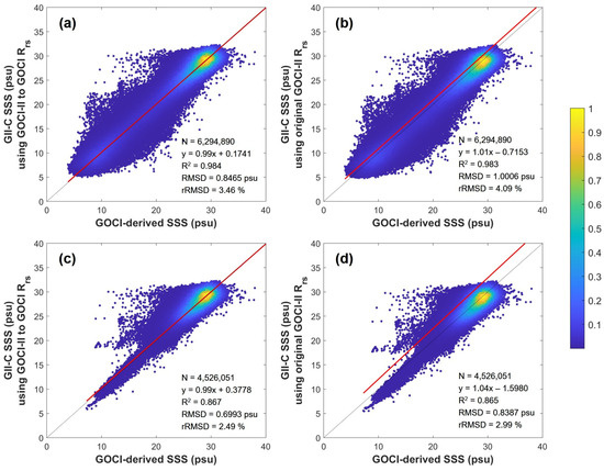
Figure 4.
Scatterplots comparing the GOCI-derived SSS with GII-C SSS, distinguishing between SSS estimates derived from adjusted GOCI-II Rrs data (a,c) and those using original GOCI-II Rrs data (b,d). The results for all August 2020 pixels are shown in (a,b), while (c,d) exclude GOCI-II pixels that were flagged as turbid pixels. The color bar depicts data density on a logarithmic scale.
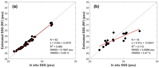
Figure 5.
Modeling results from the random forest (RF) model, using in situ data for calibration (a) and validation (b), demonstrating the model’s performance in estimating SSS.
Table 3 and Figure 6 and Figure 7 provide a comprehensive comparison between satellite-derived SSS and in situ data from both the I-ORS and the NIFS. Furthermore, Figure 7 shows daily comparisons of in situ I-ORS data with satellite-derived SSS products for August 2020 and 2021. These comparisons encompassed the GII-C SSS, GII-RF SSS, GOCI-derived SSS, and SMAP L2B and L3 SSS against their respective in situ datasets. ‘GII-RF SSS’ represents the results from applying the RF model, developed with GOCI Rrs and in situ data (Figure 5), to the adjusted GOCI-II Rrs according to conversion equations outlined in Table 2. The analyses of fixed-point I-ORS and broader NIFS data over a larger area were calculated separately (Table 3 and Figure 6). Both the GOCI and GOCI-II data encountered cloud interference, whereas the SMAP L2B data, being along-track, could not cover the entire study area daily. Conversely, interpolated SMAP L3 data offered a more comprehensive set of in situ match-ups compared to other satellite-derived SSS datasets. All of the GOCI-II-derived SSS estimates, GII-C SSS, and GII-RF SSS showed similar accuracy levels in validation against in situ data (Table 3). For all considered in situ data, the R2, RMSD, and rRMSD for GII-C SSS were 0.110, 2.401 psu, and 7.99%, respectively, while for GII-RF SSS, they were 0.115, 1.927 psu, and 6.41%, respectively. It was observed that some data points underestimated by GII-C SSS were more accurately estimated by GII-RF SSS (Figure 6 and Figure 7), highlighting the potential of machine learning-based SSS estimation in refining SSS estimations. Despite the similar correlations between GOCI-II-derived SSS estimates and GOCI-derived SSS with all in situ data, they were lower than those observed for SMAP SSS products (Table 3) and tended to underestimate SSS values (Figure 6 and Figure 7). On August 30 and 31, 2020, significant discrepancies were noted between GII-C SSS, GII-RF SSS, and GOCI-derived SSS compared to SMAP SSS products and the in situ data (Figure 7). These differences will be further analyzed in Section 5. Due to SMAP’s lower spatial resolution (25 km compared to 500 m for GOCI and 250 m for GOCI-II), it covers a larger area with a single observation value, possibly resulting in less pronounced SSS fluctuations. The daily variation in SMAP SSS was less pronounced than that observed in the fixed I-ORS data (Figure 7). Among the two SMAP SSS products, the real-time observed SMAP L2B SSS showed a stronger correlation with in situ data than the SMAP L3 SSS data, which relied on interpolation using past and future data [36,37] (Table 3). Comparatively, the broader NIFS data showed stronger correlations with the satellite-derived SSS than the fixed-point I-ORS data. While NIFS data provided snapshots at a specific location, the fixed-point I-ORS data offered insight into the diurnal cycle at a constant location. The fixed I-ORS data covered more days in the dynamic ECS, especially during the summer LSW plume period, but showed a lower correlation with satellite-derived SSS, which may not have accurately captured dynamic SSS variations.

Table 3.
Table displaying the sample size (N) and validation results for various SSS datasets: GII-C SSS, GII-RF SSS, GOCI-derived SSS, SMAP L2B SSS, and SMAP L3 SSS. Validation results are provided for three distinct datasets: in situ data exclusively from the I-ORS, solely from the NIFS, and a combined dataset encompassing both the I-ORS and NIFS.
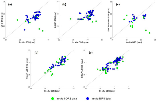
Figure 6.
Scatterplots comparing in situ data with the GII-C SSS (a), GII-RF SSS (b), GOCI-derived SSS (c), SMAP L2B SSS (d), and SMAP L3 SSS (e), distinguishing between I-ORS data (green circles) and NIFS data (blue circles).
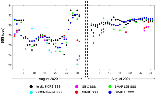
Figure 7.
The daily SSS comparison between the in situ I-ORS data and various satellite-derived SSS products for August 2020 and 2021, with the X-axis marking the days of August.
5. Discussions for limitations and Future Improvements of GOCI-II-Derived SSS
Considering the strong correlation observed between the SMAP SSS products and in situ data, as detailed in Table 3 and illustrated in Figure 6 and Figure 7, we undertook a detailed comparison to identify the limitations of the GOCI-II-derived SSS. Figure 8 illustrates the comparison between GOCI-II-derived SSS and SMAP SSS products, following the adjustment of the GOCI-II-derived SSS resolution (250 m) to align with that of the SMAP SSS (25 km). Samples from turbid waters were excluded from this comparison due to the increased uncertainty in GOCI-II Rrs measurements under such conditions, as evidenced in Figure 4. It is noteworthy that the GII-RF SSS showed superior performance to the GII-C SSS in comparison with in situ data; however, its limitations became apparent against SMAP SSS products. The GII-RF SSS model, trained using in situ data ranging from 25 to 35 psu, struggled to accurately estimate values outside this range (Figure 5a,b), underscoring the necessity for incorporating a wide array of data in training machine learning models to enhance their sophistication. Between the two GOCI-II-derived SSS models analyzed in this study, the GII-C SSS appeared to provide more reasonable results than the GII-RF SSS.
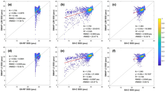
Figure 8.
Scatterplots comparing the GOCI-II-derived SSS with the SMAP L2B SSS (a–c) and SMAP L3 SSS (d–f), covering all pixels from August 2020 to 2021. (a,b,d,e) include the entire dataset, whereas (c,f) focus specifically on pixels from GOCI-II data not classified as turbid. The color bar depicts data density on a logarithmic scale.
In comparisons of the SMAP L2B and L3 SSS with the GII-C SSS, similar patterns emerged. Notably, samples showing significant deviations predominantly came from turbid water (Figure 4). The correlation between the GII-C SSS and SMAP SSS products improved significantly when excluding turbid water samples. Specifically, for the comparison between the SMAP L2B SSS and GII-C SSS, the entire dataset exhibited an R2 of 0.325, RMSD of 6.0653 psu, and rRMSD of 23.47%, with improvements noted upon excluding turbid water samples, resulting in an R2 of 0.137, RMSD of 2.9409 psu, and rRMSD of 10.30%. We cannot be certain whether the errors in the GOCI-II-derived SSS are due to atmospheric correction in turbid waters or the imperfect relationship between SSS and the GOCI-II Rrs. However, since the accuracy of the GOCI-II atmospheric correction for turbid water has been improved with two more bands (i.e., 620 and 709 nm) that are robust for a wide range of turbidity and different sediment types [31], we expect enhanced accuracy of the GOCI-II-derived SSS. The underestimation of the GOCI-II Rrs in highly turbid waters was mitigated through the adoption of new atmospheric correction techniques [31]. The algorithms for the GOCI-II currently rely on sensor data acquired prior to its launch. There is potential for enhanced accuracy in GOCI-II-derived SSS within turbid waters if atmospheric corrections are further refined based on direct GOCI-II observations.
Figure 9 shows the SSS distribution as captured by each satellite at UTC03 on August 30, 2020, a date notable for substantial discrepancies between GII-C SSS and both SMAP SSS products, as well as in situ data (Figure 7). It is essential to mention that only slots 7 and 10 from the 12 available slots in the GOCI-II were used for this analysis, which explains the map’s coverage limitation to regions above 31° North latitude (Figure 9a). The finer spatial resolution of the GOCI-II and GOCI products provides a more detailed visualization of SSS distribution when compared to the broader SMAP SSS products. Nonetheless, the SSS values at the I-ORS location (denoted by a black circle in Figure 9) significantly diverged from expectations (Figure 7). Given that SSS calculations are based on Rrs, the GII-C SSS (alongside GOCI-derived SSS) closely follows the distribution pattern observed in the GOCI-II Rrs data (Figure 10). To counterbalance Rrs influences, it is proposed that additional salinity-related variables, such as SST, which has a temperature-dependent sensitivity to seawater salinity at the L-band [13], be included in the model. This approach is supported by the strong correlation between SSS and SST, making SST a frequently used input in various SSS estimation studies [19,38,41,47]. For instance, a prior study [19] using GOCI Rrs data and additional parameters for SSS estimation in the ECS highlighted the pivotal role of SST in accurate SSS estimation within this region. Hence, incorporating SST as a supplementary input alongside Rrs is anticipated to mitigate Rrs’s impact and improve the precision of both GII-C SSS and GII-RF SSS estimation in the ECS. By utilizing the enhanced spatial resolution of the GOCI-II-derived SSS, it becomes feasible to more accurately map the highly dynamic LSW plume in the ECS, offering a finer depiction of its distribution.
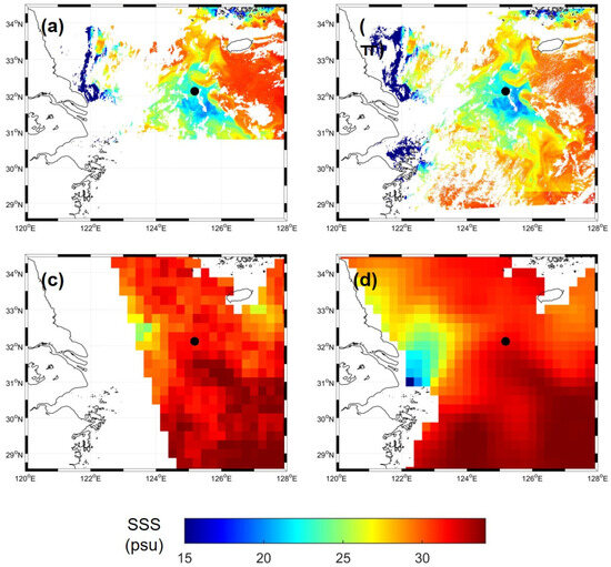
Figure 9.
Spatial distribution maps of SSS as derived from GII-C SSS (a), GOCI-derived SSS (b), SMAP L2B SSS (c), and SMAP L3 SSS (d) data at UTC03 on 30 August 2020, with the I-ORS highlighted by a black circle.
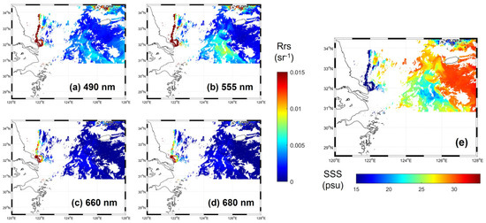
Figure 10.
Spatial distribution of GOCI-II Rrs (a–d) and the resultant GII-C SSS (e) for UTC03 on 30 August 2020, illustrating the close alignment between Rrs and SSS estimations.
In this study, we specifically selected slots 7 and 10 of the GOCI-II for analysis. While slots 9 and 6 also encompass the ECS region, they were omitted due to the noticeable deviations observed between these slots. Figure 11c shows the SSS derived from the GII-C SSS using a combined analysis of slots 6, 7, 9, and 10. Figure 11b marks the boundaries of each GOCI-II slot, identified by corresponding colors and numbers. A distinct boundary between the up-and-down slots 9–10 and 6–7 is visible at approximately 31° latitude, and a subtler boundary between the left-and-right slots 7 and 10 can be discerned at approximately 123.5° longitude. These boundaries arise from radiance disparities triggered by the different observation times associated with each slot in the GOCI-II [47]. Adjacent slots in the GOCI-II exhibit overlapping regions, spanning approximately 150 to 200 pixels. Prior research [47] analyzed the radiometric discrepancies across the level 1B slots of the GOCI-II, using images from UTC03 on February 21, 2021. The deviations calculated between each adjacent slot showed greater disparities between slots 9 and 10 compared to other vertically aligned slots for the 490, 555, 660, and 680 nm bands pertinent to his study. This discrepancy leads to pronounced boundaries in Rrs, which in turn, affects the SSS estimation. For example, in slot 6, numerous pixels near the boundary with slots 6–7 were excluded due to atmospheric correction failures, as indicated by the flag. This issue could be ascribed to radiance differences between slots, potentially resulting from pixel response nonuniformity (PRNU) during the GOCI-II in-orbit test period in August 2020. Future investigations should aim to further explore these phenomena, conducting comprehensive statistical analyses and vicarious correction studies with an expanded dataset to enhance consistency across adjacent slots.
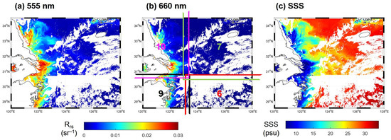
Figure 11.
Spatial distribution of the GOCI-II Rrs at 555 nm (a), 660 nm (b), and GOCI-II-derived SSS (c) at UTC03 on 15 August 2020. (b) Delineates each GOCI-II slot with matching boundaries and slot numbers, highlighting the spatial variability across the slots.
Although SMAP SSS products exhibit higher accuracy compared to both GOCI- and GOCI-II-derived SSS products, the superior spatiotemporal resolution of the GOCI-II proves more advantageous monitoring the rapid changes in LSW and SSS within coastal regions. Hence, future efforts will focus on enhancing the accuracy of the GOCI-II-derived SSS through several approaches. This study was limited to data from August, in line with previous research [8], and exclusively analyzed images collected at UTC03. The brief overlap period between the GOCI and GOCI-II further constrained data availability. Nevertheless, improving the precision of GOCI-II-derived SSS estimations remains feasible by refining algorithms specifically tailored for the GOCI-II. Over the last two years, from July 2020 to the present, a significant amount of GOCI-II data has been accumulated, alongside a growing collection of in situ data. Utilizing all 10 hourly images provided by the GOCI-II each day (Table 1) can reveal diurnal variations in SSS, enabling the monitoring of the dynamic LSW plume in the ECS on an hourly basis. Moreover, it is possible to devise an integrated SSS estimation algorithm that adapts to various times and seasons, leveraging complete monthly datasets for insights and even predictions based on hourly and monthly monitoring. To develop an integrated SSS estimation algorithm suited to the GOCI-II and capable of handling diverse temporal and seasonal variations, a machine learning approach is preferable to simple equation-based methods. Machine learning approaches have been effectively applied for SSS estimation in various regions [19,41,45,48] and for developing more complex algorithms for global SSS estimation [44]. The RF model examined in this study showed greater uncertainty, attributed to the limited scope and diversity of training samples. However, where the GII-C SSS underestimated, the GII-RF SSS yielded improved accuracy (Figure 6), underscoring the potential benefits of employing machine learning in SSS estimation. With an enlarged dataset encompassing extended periods and multiple months, machine learning can accurately model the intricate and non-linear relationships between input variables and SSS, considering temporal and seasonal changes [13]. Furthermore, alongside GOCI-II Rrs, incorporating additional variables such as SST into the machine learning model can enrich the development of a more sophisticated GOCI-II SSS estimation algorithm. While the high spatiotemporal resolution of GOCI and GOCI-II is beneficial, occasional cloud cover introduces data gaps. Recent advancements in deep learning have proven effective in interpolating satellite images to fill these gaps [49,50]. Beyond merely estimating SSS, deep learning approaches could facilitate continuous SSS monitoring in the ECS, showcasing the evolving role of advanced computational methods in satellite data analysis and application.
6. Conclusions
This study established continuity between GOCI-derived SSS and GOCI-II-derived SSS products, facilitating the ongoing monitoring of LSW plumes in the ECS. This continuity was achieved by adjusting the GOCI-II Rrs to match the GOCI Rrs and employing both Choi’s equation and an RF model developed based on GOCI data. The correlation between the GOCI-derived SSS and GII-C SSS was strong, exhibiting an R2 of 0.984 and an RMSD of 0.8465 psu. Moreover, the machine learning-based GII-RF SSS showed improved estimates for some samples compared to the GII-C SSS. This study has identified several areas for enhancing the accuracy of GOCI-II-derived SSS products:
- Calibration enhancements: The accuracy of the GOCI-II-derived SSS is compromised by the algorithm’s reliance on pre-launch data, especially in turbid waters and across slot boundaries. Tailored atmospheric corrections and vicarious calibration specific to GOCI-II could address these issues.
- Extended temporal coverage: Limited to UTC03 images from August, the study acknowledges the vast data collection by the GOCI-II over the three years since its launch. This presents an opportunity to develop an integrated model capable of estimating SSS throughout different times and seasons.
- Incorporating additional variables: This study’s SSS estimation relied solely on four Rrs bands (490, 555, 660, and 680 nm). Expanding the range of Rrs bands and including SST, which is closely related to SSS in the ECS, could refine the accuracy of the GOCI-II-derived SSS. Machine learning approaches capable of handling the complex non-linear relationships between various input variables and seasonal changes could be instrumental in this enhancement.
The unique advantage of the GOCI-II, with its unparalleled spatiotemporal resolution, becomes increasingly significant as the precision of the GOCI-II-derived SSS improves. Utilizing the GOCI-II for the real-time, hourly monitoring and prediction of SSS within the LSW plume enhances our understanding of and ability to mitigate its impact. Moreover, the analysis of over a decade’s worth of data from the GOCI series presents a valuable resource for climate studies and future forecasts utilizing SSS data.
Author Contributions
Conceptualization, E.J. and J.-K.C.; methodology, E.J. and J.-K.C.; data analysis, E.J., J.-K.C. and J.-H.A.; writing—original draft preparation, E.J.; supervision, J.-K.C.; funding acquisition, J.-K.C. All authors have read and agreed to the published version of the manuscript.
Funding
This research was supported by the Korea Institute of Marine Science & Technology Promotion (KIMST) funded by the Ministry of Oceans and Fisheries (20220546) and the National Research Foundation of Korea (NRF) grant funded by the Ministry of Science and ICT of Korea (MSIT) (RS-2024-00356738).
Data Availability Statement
The data used in this study are freely available as follows; GOCI-II data (https://www.nosc.go.kr/eng/main.do;jsessionid=9AD4DCA9A97FF630B243505676CC1000.noscwasroute21 (accessed on 15 November 2022)) and SMAP L3 data (https://podaac.jpl.nasa.gov/dataset/SMAP_JPL_L3_SSS_CAP_8DAY-RUNNINGMEAN_V5 (accessed on 7 December 2022)).
Conflicts of Interest
The authors declare no conflicts of interest.
References
- Son, Y.B.; Choi, J.K. Mapping the Changjiang Diluted Water in the East China Sea during summer over a 10-year period using GOCI satellite sensor data. Front. Mar. Sci. 2022, 9, 1024306. [Google Scholar] [CrossRef]
- Moon, J.H.; Kim, T.; Son, Y.B.; Hong, J.S.; Lee, J.H.; Chang, P.H.; Kim, S.K. Contribution of low-salinity water to sea surface warming of the East China Sea in the summer of 2016. Prog. Oceanogr. 2019, 175, 68–80. [Google Scholar] [CrossRef]
- Moh, T.; Cho, J.H.; Jung, S.K.; Kim, S.H.; Son, Y.B. Monitoring of the Changjiang River plume in the East China Sea using a wave glider. J. Coast. Res. 2018, 85, 26–30. [Google Scholar] [CrossRef]
- Senjyu, T.; Enomoto, H.; Matsuno, T.; Matsui, S. Interannual salinity variations in the Tsushima Strait and its relation to the Changjiang discharge. J. Oceanogr. 2006, 62, 681–692. [Google Scholar] [CrossRef]
- Kim, H.C.; Yamaguchi, H.; Yoo, S.; Zhu, J.; Okamura, K.; Kiyomoto, Y.; Tanaka, K.; Kim, S.W.; Park, T.; Oh, I.S.; et al. Distribution of Changjiang diluted water detected by satellite chlorophyll-a and its interannual variation during 1998–2007. J. Oceanogr. 2009, 65, 129–135. [Google Scholar] [CrossRef]
- Kwon, H.K.; Kim, G.; Hwang, J.; Lim, W.; Park, J.W.; Kim, T.H. Significant and conservative long-range transport of dissolved organic nutrients in the Changjiang diluted water. Sci. Rep. 2018, 8, 12768. [Google Scholar] [CrossRef] [PubMed]
- Zeng, X.; He, R.; Zong, H. Variability of Changjiang Diluted Water revealed by a 45-year long-term ocean hindcast and Self-Organizing Maps analysis. Cont. Shelf Res. 2017, 146, 37–46. [Google Scholar] [CrossRef]
- Choi, J.K.; Son, Y.B.; Park, M.S.; Hwang, D.J.; Ahn, J.H.; Park, Y.G. The Applicability of the Geostationary Ocean Color Imager to the Mapping of Sea Surface Salinity in the East China Sea. Remote Sens. 2021, 13, 2676. [Google Scholar] [CrossRef]
- Sung, T.; Sim, S.; Jang, E.; Im, J. Estimation of High Resolution Sea Surface Salinity Using Multi Satellite Data and Machine Learning. Korean J. Remote Sens. 2022, 38, 747–763. [Google Scholar]
- Kim, D.W.; Kim, S.H.; Jo, Y.H. A Development for Sea Surface Salinity Algorithm Using GOCI in the East China Sea. Korean J. Remote Sens. 2021, 37, 1307–1315. [Google Scholar]
- Reul, N.; Grodsky, S.A.; Arias, M.; Boutin, J.; Catany, R.; Chapron, B.; D’Amico, F.; Dinnat, E.; Donlon, C.; Fore, A.; et al. Sea surface salinity estimates from spaceborne L-band radiometers: An overview of the first decade of observation (2010–2019). Remote Sens. Environ. 2020, 242, 111769. [Google Scholar] [CrossRef]
- Dinnat, E.P.; Le Vine, D.M.; Boutin, J.; Meissner, T.; Lagerloef, G. Remote sensing of sea surface salinity: Comparison of satellite and in situ observations and impact of retrieval parameters. Remote Sens. 2019, 11, 750. [Google Scholar] [CrossRef]
- Kim, Y.J.; Han, D.; Jang, E.; Im, J.; Sung, T. Remote sensing of sea surface salinity: Challenges and research directions. GIScience Remote Sens. 2023, 60, 2166377. [Google Scholar] [CrossRef]
- Wang, J.; Deng, Z. Development of a MODIS data based algorithm for retrieving nearshore sea surface salinity along the northern Gulf of Mexico coast. Int. J. Remote Sens. 2018, 39, 3497–3511. [Google Scholar] [CrossRef]
- Zhao, J.; Temimi, M.; Ghedira, H. Remotely sensed sea surface salinity in the hyper-saline Arabian Gulf: Application to landsat 8 OLI data. Estuar. Coast. Shelf Sci. 2017, 187, 168–177. [Google Scholar] [CrossRef]
- Cao, K.; Sun, W.; Chen, L.; Meng, J.; Zhang, J. Retrieval and Analysis of Sea Surface Salinity in the Adjacent Waters of the Yangtze River Estuary Based on Multisource Satellite Data. J. Coast. Res. 2020, 36, 590–599. [Google Scholar] [CrossRef]
- Qing, S.; Zhang, J.; Cui, T.; Bao, Y. Retrieval of sea surface salinity with MERIS and MODIS data in the Bohai Sea. Remote Sens. Environ. 2013, 136, 117–125. [Google Scholar] [CrossRef]
- Urquhart, E.A.; Zaitchik, B.F.; Hoffman, M.J.; Guikema, S.D.; Geiger, E.F. Remotely sensed estimates of surface salinity in the Chesapeake Bay: A statistical approach. Remote Sens. Environ. 2012, 123, 522–531. [Google Scholar] [CrossRef]
- Kim, D.W.; Park, Y.J.; Jeong, J.Y.; Jo, Y.H. Estimation of hourly sea surface salinity in the east China sea using geostationary ocean color imager measurements. Remote Sens. 2020, 12, 755. [Google Scholar] [CrossRef]
- Sasaki, H.; Siswanto, E.; Nishiuchi, K.; Tanaka, K.; Hasegawa, T.; Ishizaka, J. Mapping the low salinity Changjiang Diluted Water using satellite-retrieved colored dissolved organic matter (CDOM) in the East China Sea during high river flow season. Geophys. Res. Lett. 2008, 35. [Google Scholar] [CrossRef]
- Keith, D.J.; Lunetta, R.S.; Schaeffer, B.A. Optical models for remote sensing of colored dissolved organic matter absorption and salinity in New England, Middle Atlantic and gulf coast Estuaries USA. Remote Sens. 2016, 8, 283. [Google Scholar] [CrossRef]
- Chen, S.; Hu, C. Estimating sea surface salinity in the northern Gulf of Mexico from satellite ocean color measurements. Remote Sens. Environ. 2017, 201, 115–132. [Google Scholar] [CrossRef]
- Bi, J.; Liu, Y.; Kong, X.; Wang, L.; Cai, X.; Nie, L.; Zhan, C.; Li, G.; Wang, F.; Wang, X.; et al. An improved sea surface salinity retrieval algorithm for the Chinese Bohai Sea based on hyperspectral reconstruction and its applicability analysis. J. Sea Res. 2023, 195, 102437. [Google Scholar] [CrossRef]
- Sun, D.; Su, X.; Qiu, Z.; Wang, S.; Mao, Z.; He, Y. Remote Sensing Estimation of Sea Surface Salinity from GOCI Measurements in the Southern Yellow Sea. Remote Sens. 2019, 11, 775. [Google Scholar] [CrossRef]
- Nakada, S.; Kobayashi, S.; Hayashi, M.; Ishizaka, J.; Akiyama, S.; Fuchi, M.; Nakajima, M. High-resolution surface salinity maps in coastal oceans based on geostationary ocean color images: Quantitative analysis of river plume dynamics. J. Oceanogr. 2018, 74, 287–304. [Google Scholar] [CrossRef]
- Liu, J.; Bellerby, R.G.; Zhu, Q.; Ge, J. Estimating sea surface salinity in the East China Sea using satellite remote sensing and machine learning. Earth Space Sci. 2023, 10, e2023EA003230. [Google Scholar] [CrossRef]
- Zhang, L.; Zhang, Y.; Yin, X. Aquarius sea surface salinity retrieval in coastal regions based on deep neural networks. Remote Sens. Environ. 2023, 284, 113357. [Google Scholar] [CrossRef]
- Choi, J.K.; Park, M.S.; Han, K.S.; Kim, H.C.; Im, J. One Year of GOCI-II Launch Present and Future. Korean J. Remote Sens. 2021, 37, 1229–1234. [Google Scholar]
- Ahn, J.H.; Park, Y.J. Atmospheric Correction Algorithm for GOCI-II data. In GOCI-II Algorithm Theoretical Basis Document; Korea Ocean Satellite Center of Korea Institute of Ocean Science and Technology: Busan, Republic of Korea, 2021. [Google Scholar]
- Ahn, J.H.; Park, Y.J. Estimating water reflectance at near-infrared wavelengths for turbid water atmospheric correction: A preliminary study for GOCI-II. Remote Sens. 2020, 12, 3791. [Google Scholar] [CrossRef]
- Ahn, J.H.; Kim, K.S.; Lee, E.K.; Bae, S.J.; Lee, K.S.; Moon, J.E.; Han, T.H.; Park, Y.J. Introduction of GOCI-II Atmospheric Correction Algorithm and Its Initial Validations. Korean J. Remote Sens. 2021, 37, 1259–1268. [Google Scholar]
- Ocean Data in Grid Framework. Available online: http://www.khoa.go.kr/oceangrid/gis/category/reference/distribution.do (accessed on 12 January 2023).
- Ha, K.J.; Nam, S.; Jeong, J.Y.; Moon, I.J.; Lee, M.; Yun, J.; Jang, C.J.; Kim, Y.S.; Byun, D.S.; Heo, K.Y.; et al. Observations utilizing Korea Ocean Research Stations and their applications for process studies. Bull. Am. Meteorol. Soc. 2019, 100, 2061–2075. [Google Scholar] [CrossRef]
- NIFS Korea Oceanographic Data Center. Available online: https://www.nifs.go.kr/kodc/soo_list.kodc (accessed on 12 January 2023).
- Fore, A.G.; Yueh, S.H.; Tang, W.; Stiles, B.W.; Hayashi, A.K. Combined active/passive retrievals of ocean vector wind and sea surface salinity with SMAP. IEEE Trans. Geosci. Remote Sens. 2016, 54, 7396–7404. [Google Scholar] [CrossRef]
- Fore, A.; Yueh, S.; Tang, W.; Hayashi, A. SMAP Salinity and Wind Speed Data User’s Guide Version 5.0; Jet Propulsion Laboratory, California Institute of Technology: Pasadena, CA, USA, 2020. [Google Scholar]
- Qin, S.; Wang, H.; Zhu, J.; Wan, L.; Zhang, Y.; Wang, H. Validation and correction of sea surface salinity retrieval from SMAP. Acta Oceanol. Sin. 2020, 39, 148–158. [Google Scholar] [CrossRef]
- Park, M.S.; Jung, H.C.; Lee, S.; Ahn, J.H.; Bae, S.; Choi, J.K. The GOCI-II early mission ocean color products in comparison with the GOCI toward the continuity of Chollian multi-satellite ocean color data. Korean J. Remote Sens. 2021, 37, 1281–1293. [Google Scholar]
- Kesavakumar, B.; Shanmugam, P.; Venkatesan, R. Enhanced Sea Surface Salinity Estimates Using Machine-Learning Algorithm With SMAP and High-Resolution Buoy Data. IEEE Access 2022, 10, 74304–74317. [Google Scholar] [CrossRef]
- Han, K.H.; Hong, S. Ocean Salinity Retrieval and Prediction for Soil Moisture Active Passive Satellite Using Data-To-Data Translation. IEEE Trans. Geosci. Remote Sens. 2023, 61, 4204415. [Google Scholar] [CrossRef]
- Rajabi-Kiasari, S.; Hasanlou, M. An efficient model for the prediction of SMAP sea surface salinity using machine learning approaches in the Persian Gulf. Int. J. Remote Sens. 2020, 41, 3221–3242. [Google Scholar] [CrossRef]
- Breiman, L. Random forests. Mach. Learn. 2001, 45, 5–32. [Google Scholar] [CrossRef]
- Jang, E.; Im, J.; Park, G.H.; Park, Y.G. Estimation of fugacity of carbon dioxide in the East Sea using in situ measurements and Geostationary Ocean Color Imager satellite data. Remote Sens. 2017, 9, 821. [Google Scholar] [CrossRef]
- Jang, E.; Kim, Y.J.; Im, J.; Park, Y.G.; Sung, T. Global sea surface salinity via the synergistic use of SMAP satellite and HYCOM data based on machine learning. Remote Sens. Environ. 2022, 273, 112980. [Google Scholar] [CrossRef]
- Kim, D.W.; Kim, S.H.; Baek, J.Y.; Lee, J.S.; Jo, Y.H. GOCI-II based sea surface salinity estimation using machine learning for the first-year summer. Int. J. Remote Sens. 2022, 43, 6605–6623. [Google Scholar] [CrossRef]
- Ahn, J.H.; Park, Y.J.; Kim, W.; Lee, B. Simple aerosol correction technique based on the spectral relationships of the aerosol multiple-scattering reflectances for atmospheric correction over the oceans. Opt. Express 2016, 24, 29659–29669. [Google Scholar] [CrossRef] [PubMed]
- Kim, W.; Lim, T.; Ahn, J.H.; Choi, J.K. A Preliminary Analysis on the Radiometric Difference Across the Level 1B Slot Images of GOCI-II. Korean J. Remote Sens. 2021, 37, 1269–1279. [Google Scholar]
- Jang, E.; Kim, Y.J.; Im, J.; Park, Y.G. Improvement of SMAP sea surface salinity in river-dominated oceans using machine learning approaches. GISci. Remote Sens. 2021, 58, 138–160. [Google Scholar] [CrossRef]
- Li, T.; Cheng, X. Estimating daily full-coverage surface ozone concentration using satellite observations and a spatiotemporally embedded deep learning approach. Int. J. Appl. Earth Obs. Geoinf. 2021, 101, 102356. [Google Scholar] [CrossRef]
- Sim, S.; Lee, E.; Seo, M.; Seong, N.H.; Jeong, D.; Woo, J.; Han, K.S. Deep neural network-based spatial gap-filling of MODIS ice surface temperatures over the Arctic using satellite and reanalysis data. Remote Sens. Lett. 2022, 13, 1213–1221. [Google Scholar] [CrossRef]
Disclaimer/Publisher’s Note: The statements, opinions and data contained in all publications are solely those of the individual author(s) and contributor(s) and not of MDPI and/or the editor(s). MDPI and/or the editor(s) disclaim responsibility for any injury to people or property resulting from any ideas, methods, instructions or products referred to in the content. |
© 2024 by the authors. Licensee MDPI, Basel, Switzerland. This article is an open access article distributed under the terms and conditions of the Creative Commons Attribution (CC BY) license (https://creativecommons.org/licenses/by/4.0/).