Article

Estimating Evapotranspiration in the Qilian Mountains Using GRACE/GRACE-FO Satellite Data

1
Lanzhou Institute of Arid Meteorology, Chinese Meteorological Administration, Gansu Province Key Laboratory of Arid Climate Change and Reducing Disaster, Meteorological Administration Key Laboratory of Arid Climate Change and Reducing Disaster, Lanzhou 730020, China
2
Lanzhou Regional Climate Center, Lanzhou 730020, China
3
Gansu Meteorological Bureau, Lanzhou 730020, China
*
Author to whom correspondence should be addressed.
Remote Sens. 2024, 16(11), 1877; https://doi.org/10.3390/rs16111877
Submission received: 18 April 2024 / Revised: 20 May 2024 / Accepted: 22 May 2024 / Published: 24 May 2024

Abstract

:
Evapotranspiration (ET) is the most significant constituent of the response to climate warming. It serves as a crucial link in the soil–vegetation–atmospheric continuum. Analyzing the driving forces and response of ET to regional-scale climate warming holds scientific significance in improving global water resource assessment methods and drought monitoring techniques. The innovation presented in this article is the calculation of ET by using GRACE/GRACE-FO satellite data through the water balance equation. The inter-annual and seasonal changes in ET in different regions of the Qilian Mountains were analyzed, along with quantifying the contribution of environmental meteorological factors to ET. The ETGRACE and ETMonitor products have good consistency, with a monthly correlation coefficient of 0.92, an NSE coefficient of 0.80, and a root mean square error of 10.38 mm. The results indicate that the increasing trend of ET in the Qilian Mountains region exhibits a “medium–high–low” distribution pattern. The rate of increase in ET is 5.2 mm/year in the central segment. In spring and summer, the overall trend of ET is an increasing one. However, the central and western segments exhibit a slight decreasing trend of ET in autumn. During winter, the southern part of the Qilian Mountains experiences a notable reduction in ET. The correlation between the changes in ET and soil moisture exhibited a strong association, with soil moisture change contributing significantly to ET: 57.8% for the eastern section, 52.8% for the middle section, and 46.9% for the western section. The thermal effect primarily controls ET variations within eastern sections, where temperature change accounts for approximately 6.7% of the total variation in ET levels. Conversely, the moisture factor dominates western sections, where precipitation change accounts for about 6.5% of the total variation in ET levels. Due to the distinct gradient characteristics of environmental meteorological factors in the central segment, the fluctuation of these factors collaboratively drives ET changes. This article provides a new approach for obtaining continuous and reliable actual evapotranspiration in high-altitude areas.

1. Introduction

ET is the process of water molecules changing from a liquid/solid form to vapor on the Earth’s surface. This process includes soil and water evaporation, vegetation canopy-intercepted precipitation evaporation, vegetation transpiration, and ice and snow sublimation [1,2]. ET links the water cycle and energy flow in the ground–air system, making it the most significant indicator of changes in water and energy [3,4]. Warming conditions strengthen the global water cycle, thereby increasing ET [5,6]. In addition, changes in vegetation can also affect ET through complex land–atmosphere interactions [7]. Accurate ET estimations are crucial to understanding the relationship between global and watershed water and energy levels. They are also essential for drought monitoring and evaluation, ecological protection and restoration, and water resource management in watersheds [8].
The Qilian Mountains are the birthplace of the Shiyang River, Hei River, and Shule River. They provide water to peripheral arid and semi-arid areas. The Qilian Mountains are exhibiting new “warming and humidification” characteristics due to global warming, and these conditions have intensified since 2004. The western section has experienced the highest level of warming, while the central area has seen the most notable increase in precipitation [9]. Using 10 CMIP6 models, some scholars analyzed the changes in temperature, precipitation, and humidity in the Qilian Mountains from 2020 to 2064 under three emission scenarios and found that the temperature increase was most significant in winter and summer under high-emission scenarios. Summer precipitation in the Qilian Mountains will increase in the future, and the possibility of “wetting” is becoming greater [10]. Therefore, against the background of new climatic characteristics in the Qilian Mountains, it is crucial to understand and estimate the ET therein accurately. Knowing its temporal and spatial variations can guide sustainable development in vegetation ecology, water resources, and surrounding climate-sensitive regions [11,12]. Researchers have used GLEAM data to scrutinize the annual ET fluctuations in the Qilian Mountains. Based on these shifts, they studied the correlations among precipitation, potential ET, and NDVI. The team unveiled that the constructive influence of precipitation and NDVI is crucial in offsetting the detrimental effects of potential ET on actual ET. Furthermore, they ascertained that the proliferation of diverse flora in the terrain substantially contributed to actual ET augmentation [13]. More knowledge is needed about the seasonal distribution and regional ET changes, the lack of which has been impeding our capacity to comprehend fluctuations in moisture levels within the local climate in the Qilian Mountains. The inadequate spatial representation of observational data is a direct consequence of the area’s limited number of observation sites. Furthermore, the assimilated and reanalyzed data from the region have low accuracy [14]. Currently, remotely sensed ET data (e.g., MODIS, JPL, and GLEAM ET) are predicated upon assumptions regarding plant responses to drought. Consequently, methods for calculating land surface ET based on physical models are deemed more robust. In accordance with the principle of mass conservation, alterations in total water storage (TWS) on land equate to the disparity between precipitation input and output from the land through ET and runoff. Presently, numerous scholars are utilizing GRACE satellite data in conjunction with a water balance methodology to estimate ET.
Traditional observation methods such as scintillators, evaporators, vortex-related systems, and flux stations can more accurately provide point scale evapotranspiration information, but cannot effectively obtain the spatial distribution of regional evapotranspiration. The water balance equation was adopted and the actual ET in Qilian Mountains was estimated in this study. The change value of regional water storage was calculated using GRACE gravity satellite data, and the actual ET could be estimated by combining rainfall and runoff data. Before applying the GRACE gravity satellite, it is often assumed that water storage remains constant over a long period due to the difficulty of observing or measuring changes in regional water storage. There is much uncertainty when calculating ET through the water balance method. However, the GRACE satellite data help us to estimate basin-scale ET changes [15,16,17]. Experts have developed a novel approach to computing surface ET using GRACE satellite data. This approach operates on the principle of basin-scale water balance and offers improved accuracy in estimating ET on a regional level when compared to traditional land surface models. The outcomes can be leveraged to assess the precision of the land surface model ET [18]. The ET of 11 major river basins around the United States was calculated using the GRACE satellites [19].
Using GRACE/GRACE-FO satellite data and ERA5 reanalysis data, following the definition of the water balance equation, water storage changes, and rainfall and runoff data, ET in different regions of the Qilian Mountains is estimated in this paper. We analyze the spatiotemporal variation trend of ET under the new characteristics of climate in the Qilian Mountains and clarify the driving force and variation difference of ET in different regions.

2. Materials and Methods
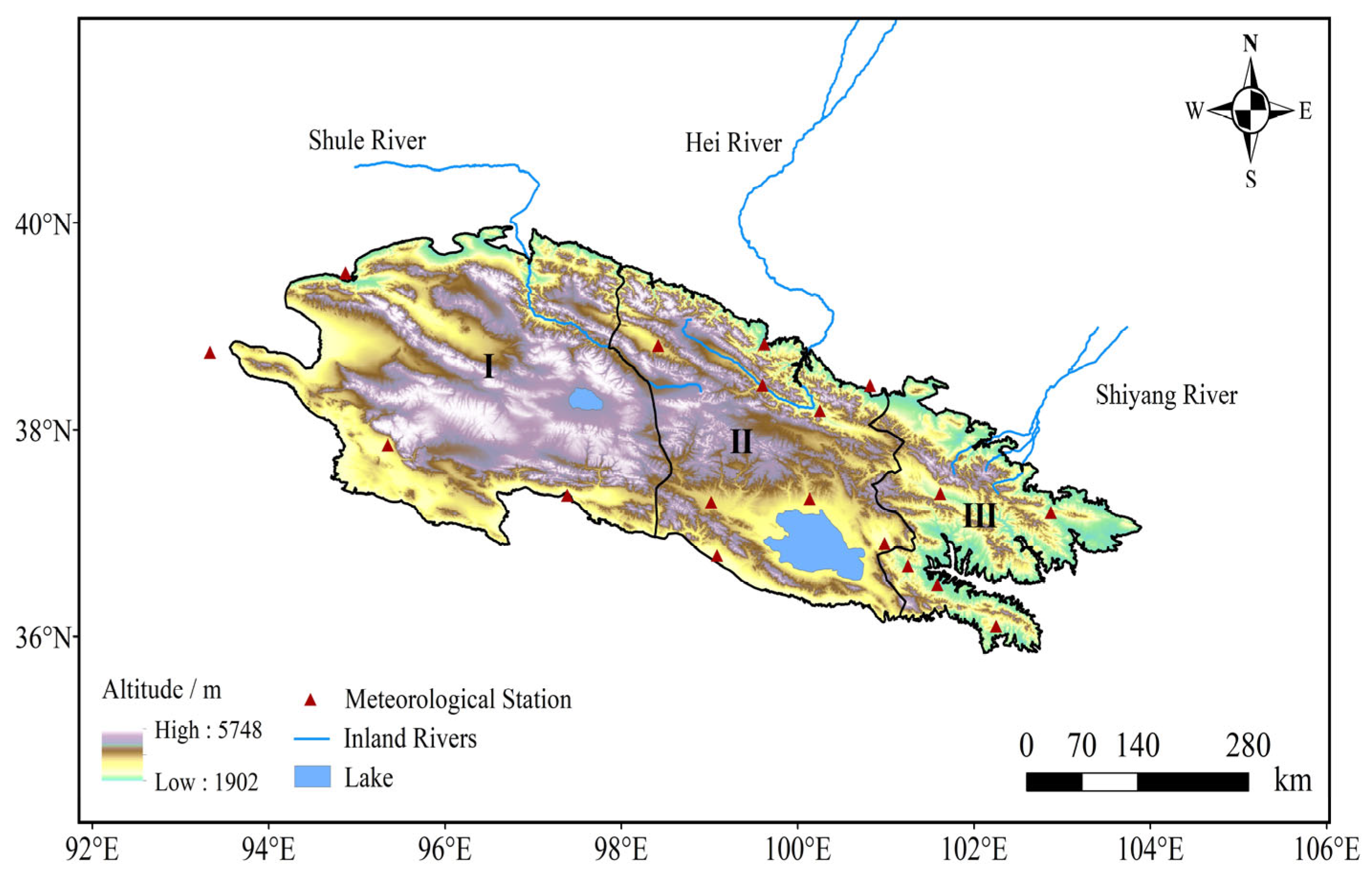
2.1. Study Region

The Qilian Mountains cover about 206,200 hectares, with elevations gradually increasing from southeast to northwest, culminating at 5752 m. This results in a distinct vertical distribution of vegetation, including desert steppe, subalpine steppe, forest, alpine meadow, and sparse alpine vegetation. These different types of vegetation can be found at varying altitudes, from low to high [20,21]. This alpine region’s natural ecosystem is delicate and highly vulnerable to climate change. Given the intricate topography and weather patterns, thoroughly analyzing the water storage and ET in this area is essential. This study divided the Qilian Mountains into three sections based on the distribution of the three inland rivers and the mountains’ orientation: eastern, central, and western sections (Figure 1).

2.2. Data

A cutting-edge GRACE observation data product, known as the global terrestrial water storage anomaly data (TWSA), has recently been introduced. This product is managed and released by three esteemed institutions: the US Jet Propulsion Laboratory (JPL), the Texas Center for Geospatial Research (CSR), and the German Geoscience Research Center (GFZ). The TWSA data represent the next generation of GRACE observation data products, specifically RL06 Mascon products. RL06 Mascon products are more user-friendly than traditional spherical harmonic coefficient products and have been designed to address leakage errors. The products have undergone rigorous validation on polar ice sheets, oceans, and extensive global river basins [22,23]. We used monthly Mascon products from January 2003 to December 2019, and the spatial resolution was 0.25° × 0.25°. When segments were missing in GRACE and GRACE-FO data records, we replaced them with multi-year monthly average data [24,25].
The DEM data resolution was 1 km, and the projection coordinate was WGS84. It was downloaded from https://www.resdc.cn/ (accessed on 13 April 2023).
The ET dataset (ETMonitor) was a global daily dataset with a 1 km resolution; the daily ET per pixel was obtained by summing each component, and the unit was mm/d [26]. The model was suitable for different land cover types. The input data mainly included remote sensing data, including GLASS products (leaf area index, vegetation coverage, and albedo), MODIS products (surface cover and snow cover), dynamic surface water coverage, ESA CCI soil moisture, and GPM precipitation. Direct validation was conducted using 251 flux stations distributed globally (covering various terrestrial ecosystems, water bodies, and ice and snow surfaces), and the estimated results were consistent with ground measurement data.
Our multi-source precipitation data included the monthly precipitation dataset (MPDC) from China, which offered a 1 km resolution. This dataset was based on CRU’s global 0.5° climate dataset. The scale scheme was downscaled in China and verified by means of 496 independent observations from meteorological stations; the verification results were reliable. We also used the GPCC precipitation data (resolution of 0.25° × 0.25°) and the ERA5 precipitation data. These data represent the latest generation of this data type. The ERA5 model combines observational data using physical laws to produce a dataset that covers specific areas and periods [27]. The current study used precipitation data from ERA5-Land with a 0.25° × 0.25° spatial resolution. Runoff data were obtained from ERA5-Land and the resolution was unified into 0.25° × 0.25°. The decadal runoff data from the Yingluo Gorge hydrological station in the Heihe River Basin, expressed in billion cubic meters per 10 days, were utilized to compute monthly discharge data for the basin. The measured monthly discharge results obtained from the hydrological station were standardized by the area of the Heihe River Basin and further transformed to derive corresponding monthly runoff depth data for the study period. The correlation coefficient between ERA5 runoff data and observed hydrological station data was determined to be 0.895, with an RMSE of 0.858.

2.3. Method

2.3.1. Calculation of Actual ET Adopt on Water Balance Equation

The equation of water balance comprises precipitation, runoff, ET, and changes in land water storage [28]. Precipitation is the primary water input route in a closed watershed, while runoff and ET are the primary water output routes. The land water storage variation reflects the difference between the water input and output in a closed watershed. Because accurate and reliable monitoring of changes in terrestrial water storage is often unavailable, the system is usually assumed to be closed, with the watershed’s terrestrial water storage change being zero over a long period in previous applications of the water balance equation. This method cannot calculate ET over a short period, and the results have significant uncertainties [29]. With research progress on regional land water storage changes, more studies have shown that the terrestrial water storage in a basin will produce significant changes under the dual impact of climate change and human activities [30], which cannot be ignored in the water balance equation of a closed basin. With the available data from the GRACE/GRACE-FO gravity satellite, changes in terrestrial water storage in large-scale watersheds can be calculated efficiently and accurately [31,32].
For an enclosed watershed system, ET can be calculated using the water balance equation [33]. This equation uses the terrestrial water storage variation, precipitation, runoff, and other hydrometeorological data. The calculation principle is as follows [34]:
E T G R A C E = P Q d s d t
d s d t T W S A t + 1 T W S A t 1 2 t
where ETGRACE is the monthly actual ET (mm), P is the monthly precipitation (mm), Q is the monthly runoff depth (mm), ds/dt is the change in inland water storage in a certain period, ∆t is the average temperature, and “TWSA (t + 1)” and “TWSA (t − 1)” are the watersheds corresponding to “(t + 1)” month and “(t − 1)” month, respectively. The terrestrial water storage anomaly, i.e., the strict form of Equation (2) [18], estimates the change in water volume based on the combined precipitation and runoff data for that month. During winter months (with low precipitation), ETGRACE is likely to be negative due to sublimation and desublimation caused by ground temperature differences. To address this, we used the gradient observation data.
In Formula (3), Δ T s represents the differences between ground and air temperature, Δ z represents the humidity difference in the surface layer, Δ q represents the specific humidity difference in the surface layer, and Δ h represents the altitude difference between air temperature and surface temperature.
E T G R A C E = Δ T s Δ z Δ q Δ h E T G R A C E

2.3.2. Evaluation Index of ET Accuracy

The evaluation indicators used in this paper include the Pearson correlation coefficient (PCC), RMSE, MRE, and the Nash efficiency coefficient. These were used to verify the results of ETGRACE and ETMonitor.
P C C = C o v E T , E T M o n i t o r V a r E T V a r E T M o n i t o r
M R E = E T E T M o n i t o r E T M o n i t o r
R M S E = E T E T M o n i t o r 2 N
N S E = 1 E T E T M o n i t o r 2 E T E T ¯ 2
Sen’s slope is an exceptional statistical method for trend analysis in long-term series data. This method is highly proficient and impervious to small outliers and missing noise values [9]. It is estimated as follows:
β = m e d i a n x j x i j i ,         j > i
If β > 0, the trend is increasing; if β = 0, the trend is not apparent; and if β < 0, the trend is downward.
The Mann–Kendall (MK) method only requires that the data obey a normal distribution without being affected by a few outliers. This method can objectively determine long-term changes and trends in data and test mutation points [35]. It has been widely used in rainfall and temperature estimations, trend tests, and ET mutation analysis. MK statistics are calculated as follows:
S = i = 1 n 1 j = i + 1 n s g n x j x i
s g n x j x i = 1 , x j x i > 0 0 , x j x i = 0 1 , x j x i < 0
where sgn is a sign function, where a negative value indicates an uptrend and a positive value indicates an uptrend, while S is the MK test statistic, a statistically tested 0.05 reliability test. The absolute value of Z > 1.96 is significant, while Z ≤ 1.96 is not [36].
To measure the influence of ET change, we combined the sensitivity coefficient and the relative change in elements. The sensitivity coefficient method is a mathematical analysis technique and a crucial measure of how changes in independent variables affect dependent variables [37]. We defined the change rate of ET according to a single impact factor x, namely:
S x = lim X 0 ( E T / E T X / X ) = E T X · X E T
where Sx is the dimensionless index convenient for comparison. A positive sensitivity coefficient means that the dependent variable increases with the independent variable, and its absolute value measures the sensitivity of the variable. The formula for the contribution degree (i.e., the ET change caused by the change in environmental factors) is as follows:
C o n X = S X · R C X
R C X = 58 × T r e n d X a v e X × 100 %
where Conx is the contribution rate to ET variation; Sx is the sensitivity coefficient; RCx is the relative variation rate; and Trendx and avex are the variation rate and the average value, respectively. For the environmental meteorological element variation, the equation that we used in our analysis is expressed as follows:
X = X X m i n
where ∆X represents the increase in the corresponding element, X is the year-by-year value of each element, and Xmin is the minimum value of each element.

3. Results

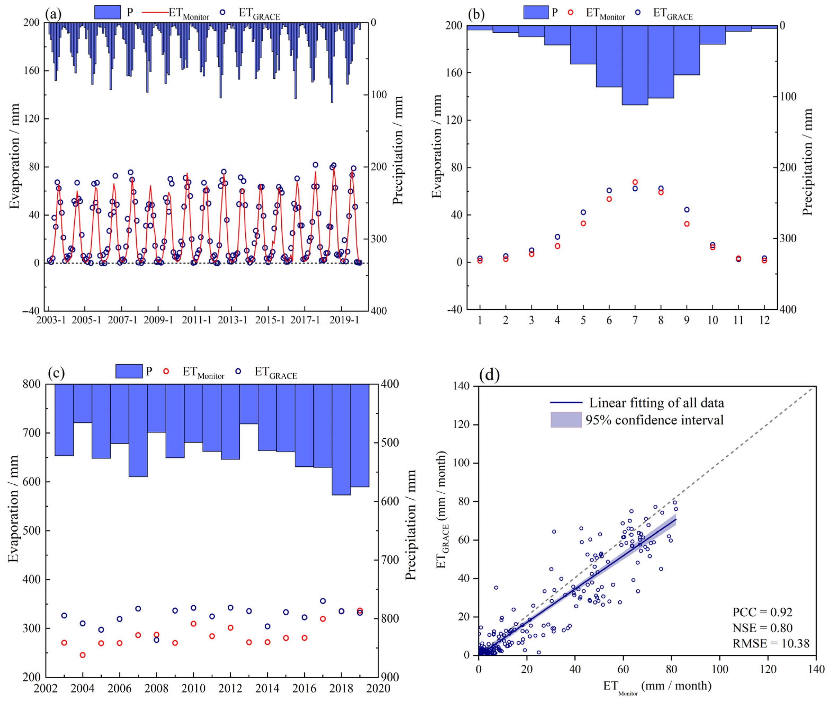
3.1. Applicability Assessment of Precipitation Data in Qilian Mountains

We compared the records from four local meteorological observation stations to assess the precision of precipitation data from ERA5, GPCC, and MPDC in the Qilian Mountains. The analysis employed statistical evaluation measures as detailed in Table 1. When comparing the correlation coefficients (PCC) at the four inspection stations, ERA5 outperformed GPCC and MPDC. Specifically, at Tuole, Menyuan, and Huangyuan stations, ERA5 had correlation coefficients above 0.9. Regarding the mean relative error (MRE), ERA5 had lower values than GPCC and MPDC at Tuole Station. At Huangyuan, the average errors of the three grid-point precipitation data were below 30%, and ERA5 was superior to GPCC.
Regarding the root mean square error (RMSE), ERA5 displayed a smaller value than others. However, the ERA5 precipitation data displayed a higher RMSE at Huangyuan Station. ERA5 precipitation data are more dependable in the Qilian Mountains. Selecting the precipitation and runoff datasets is essential when calculating ET using the water balance equation. After analyzing the options, we used ERA5 precipitation data as one input for calculating ET. We also chose ERA5 for the runoff data to ensure data consistency.

3.2. Comparison of ET Estimated Based on GRACE and ETMonitor Products

During winter, the ground temperature difference may cause a negative ETGRACE effect due to sublimation and desublimation. However, this can be rectified using Equation (3). On the monthly time scale, ETGRACE and ETMonitor have strong consistency, and there is an obvious positive response relationship with the precipitation in the Qilian Mountains. The quantitative accuracy evaluation index of the ETGRACE dataset was calculated (considering the small amount of data, PCC was not calculated on the annual scale, and the figure is omitted). The PCC and NSE of the monthly scale results of ETGRACE and ETMonitor were 0.92 and 0.80, and the RMSE was 10.38. The annual-scale NSE was −2.34, and the RMSE was 44.27. In general, using GRACE water storage and water balance equations to calculate the actual evapotranspiration in the Qilian Mountains, the results on the monthly scale depend on the annual scale (Figure 2). It is feasible to estimate ET using our method. In this study, the ETGRACE model analyzed the spatiotemporal characteristics of ET in the Qilian Mountains. It is essential to perform fundamental work for the study of surface evapotranspiration in high-altitude areas of the Eurasian continent

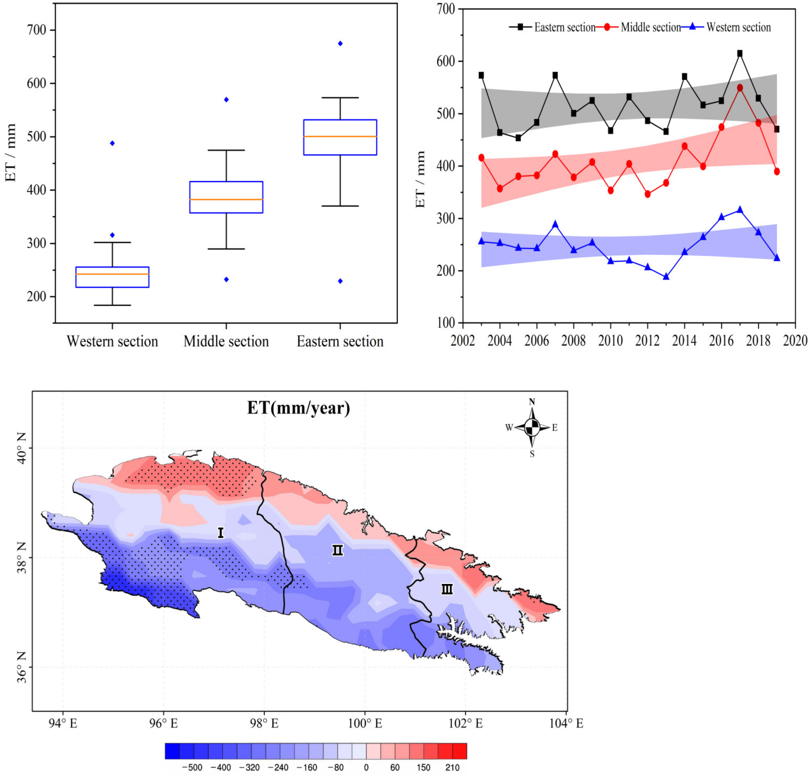
3.3. Spatiotemporal Characteristics of ET in the Qilian Mountains

3.3.1. Inter-Annual Variations

In the Qilian Mountains, the surface ET varies in different areas. The eastern section had an average ET of 494.7 mm over multiple years, while the central section evinced an annual average ET of 389.6 mm. The western section had the lowest average ET, at 253.4 mm (with the eastern section having the highest average ET, followed by the central section). In the western section, the ET levels remained relatively stable throughout the year, with only minor changes. The inter-annual variation in this area was less noticeable. However, in the northern Qilian Mountains, the annual ET showed a noticeable increase, particularly in the northwest region.
Over time, the surface ET has been increasing annually. The ET of the eastern, central, and western sections have risen by 1.7, 5.2, and 0.9 mm/a. Respectively, indicating that the central section has experienced a much higher increase than the eastern and western sections (Figure 3). The surface ET is mainly influenced by potential ET, soil moisture, and vegetation. These factors affect the required moisture conditions and are influenced by environmental meteorological factors.
The sensitivity of surface ET to climate warming is primarily influenced by atmospheric temperature, a crucial environmental factor second only to precipitation. Therefore, temperature and precipitation trends were analyzed in various regions of the Qilian Mountains. This can provide a better understanding of the spatial heterogeneity of surface ET in this area.
The eastern and middle sections experienced a rise of 0.41 and 0.33 °C/10a from 2003 to 2019, respectively. In the western section, there is no significant trend of temperaturechange (Figure 4a). During the same period, the annual precipitation generally displayed increased volatility, and the rates of the three districts from east to west were 3.05 mm/a, 3.01 mm/a, and 2.84 mm/a, respectively (Figure 4b).
The increase rate for ET in the central–eastern region is accelerating according to the analysis of the temperature and precipitation trends. The central Qilian Mountains have more snow cover and glaciers than the eastern section. As a result, the Heihe River, which originates from the central Qilian Mountains, has a more considerable runoff and drainage area. Therefore, the rate of ET increases more in the central region.
So far, we have discussed the reasons behind the sudden increase in surface ET in the central region. To provide a more detailed explanation for this, we conducted a quantitative analysis and observed how the regions in the Qilian Mountains responded to changes in temperature against the backdrop of climate warming. Figure 5 displays the annual average ET variation in various areas of the Qilian Mountains as temperature increases. Although there was a noticeable difference and dispersion in the annual average ET in the regions, the overall trend was linear, indicating that climate warming significantly influenced surface ET. The trend of annual average ET with temperature increase varied across different regions. In the central region, there was a significant increase in annual average ET with an increase in temperature, followed by the western section.
The impact of air temperature on surface ET was unique. On the one hand, temperature directly affected ET potential, with higher temperatures promoting surface ET enhancement. On the other hand, temperature indirectly affected the ET through its influence on soil moisture and vegetation. Higher temperatures increase ET, decreasing soil moisture and negatively impacting vegetation, leading to inhibited surface ET.

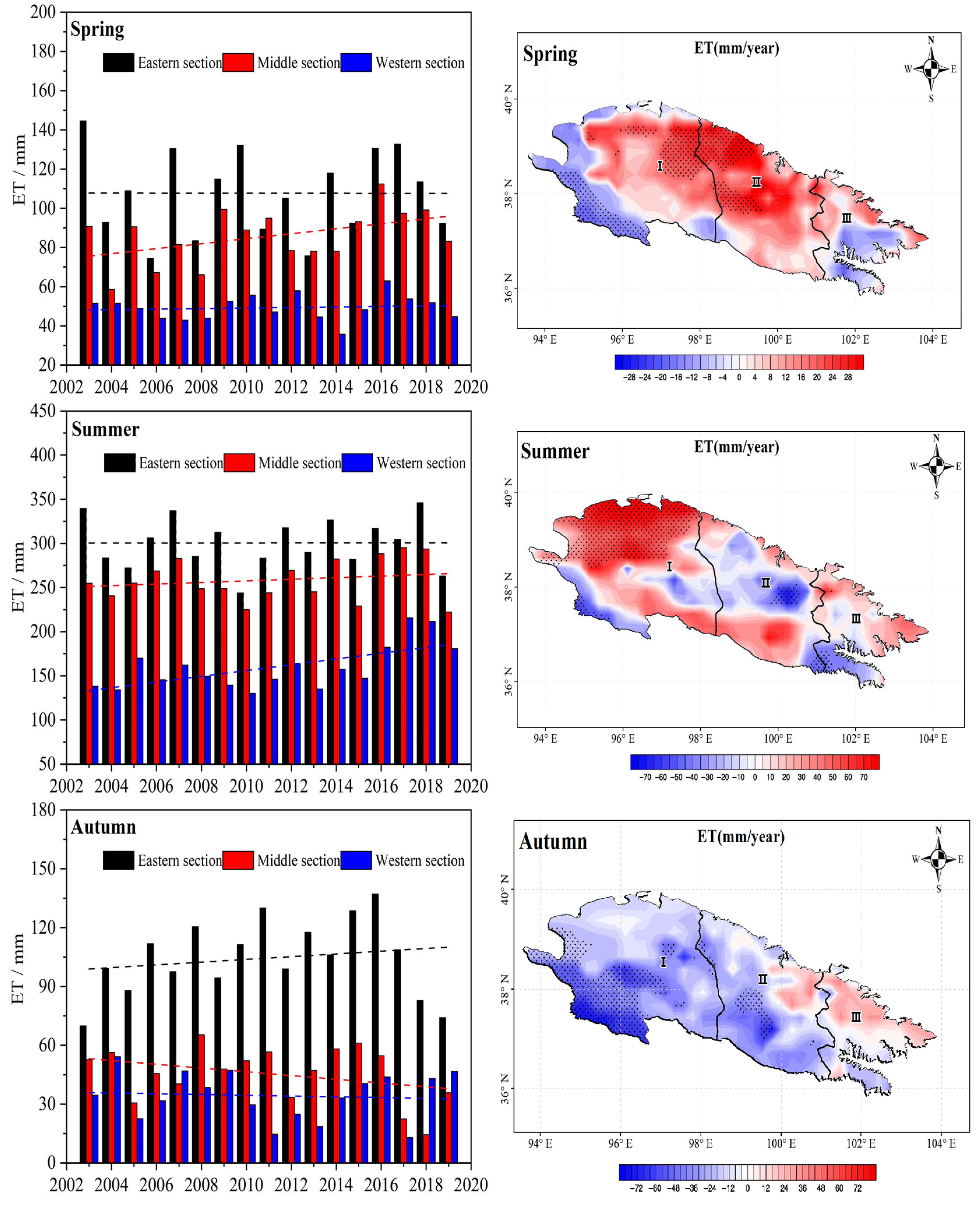
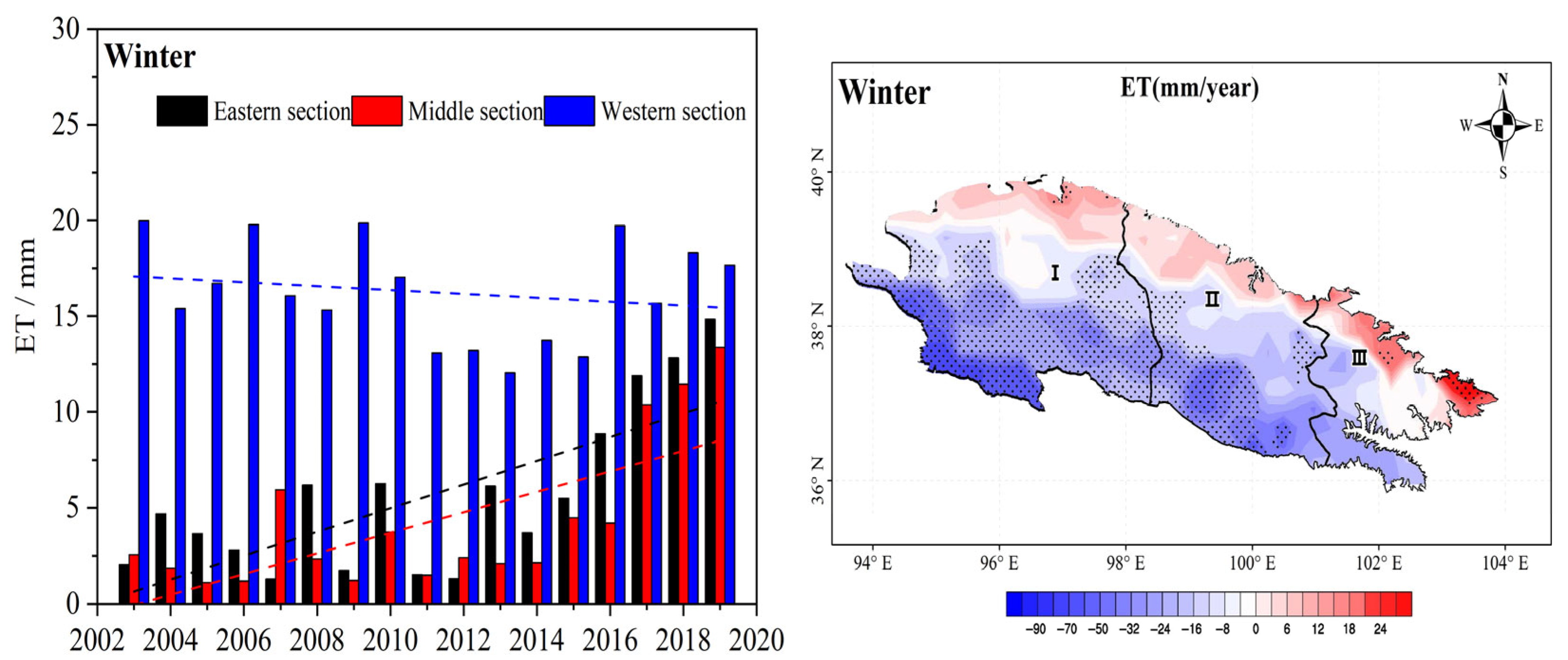
3.3.2. Seasonal Variations

To better understand the seasonal variation of ET, the spatiotemporal characteristics were calculated (Figure 6). During spring, the eastern annual ET remained consistent, while the midwest annual ET exhibited increasing trends of 1.3 mm/a and 0.1 mm/a, respectively. From a space perspective, it is evident that the ET in the Qilian Mountains had notably increased, particularly in the northwest. While there has been an increase in central–eastern areas of the western region, the ET has decreased in the west.
The eastern Qilian Mountains displayed consistent average ET levels during the summer. However, the central and western sections experienced an increase in ET levels. Specifically, the central and west sections displayed an increase rate of 0.9 and 3.3 mm/a, respectively. Regarding spatial distribution, the central Qilian Mountains exhibited an anti-phase pattern of “rising in the north and falling in the south”, which resulted in a lower overall increase rate. On the other hand, most areas in the western section displayed an upward trend, with the northwest region experiencing a significant increase.
During autumn, the increasing trend of ET in most areas in the eastern part of Qilian is 0.7 mm/a. However, this trend is −0.9 and −0.2 mm/a in the midwest region, respectively. In winter, the annual average ET increase rate in the eastern and middle sections of Qilian remains similar, i.e., 0.7 and 0.6 mm/a, respectively. The trend is −0.1 mm/a in the western section. Also, the ET experienced a significant decreasing trend.

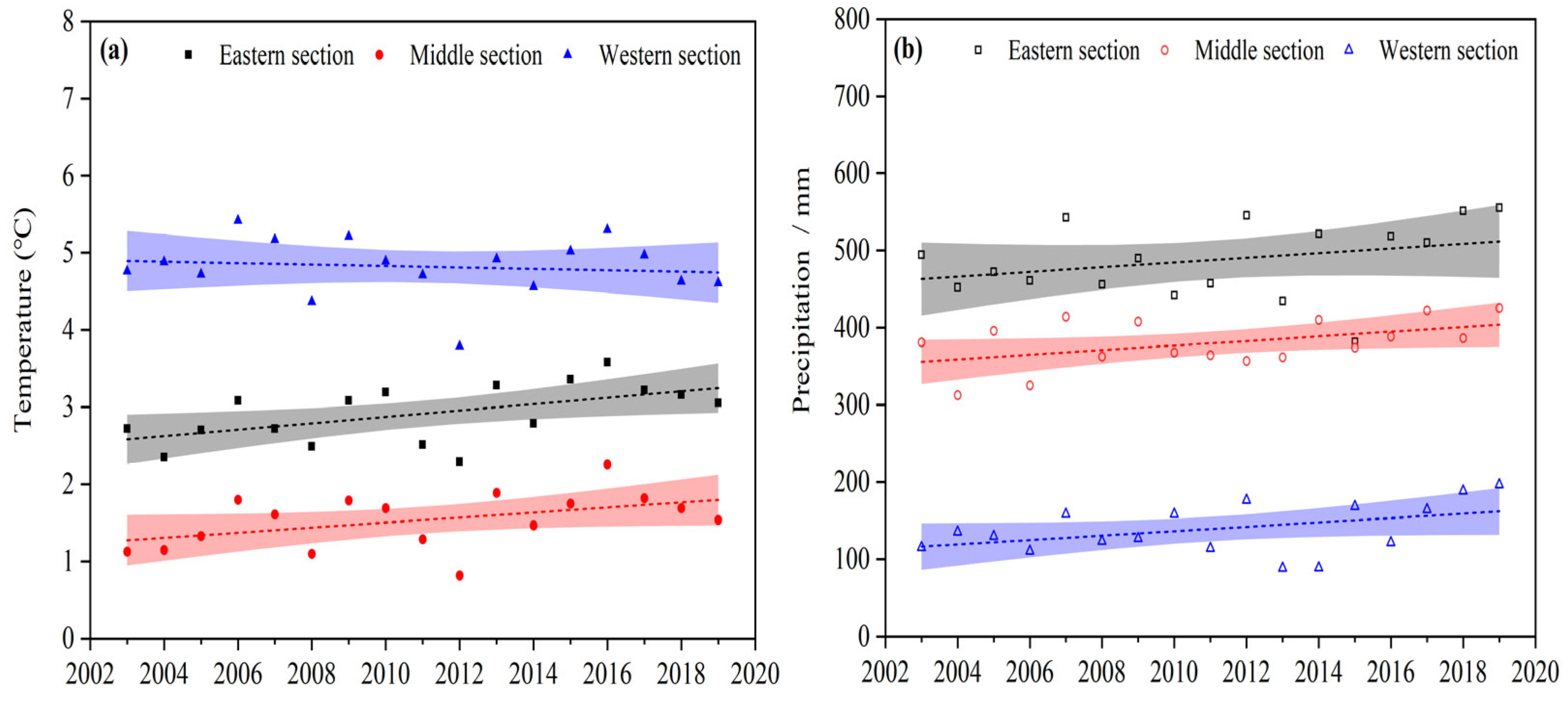
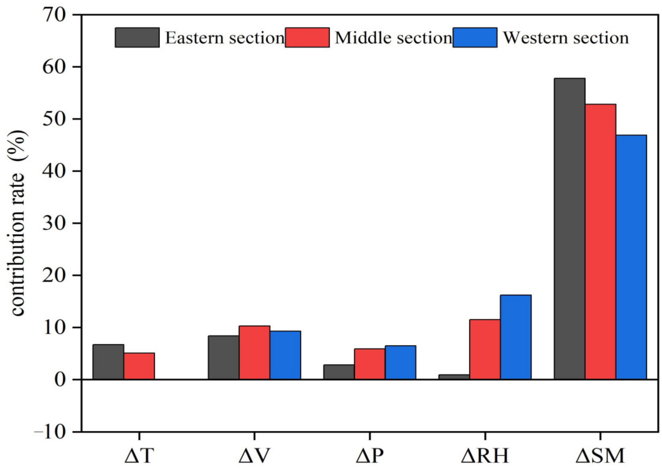
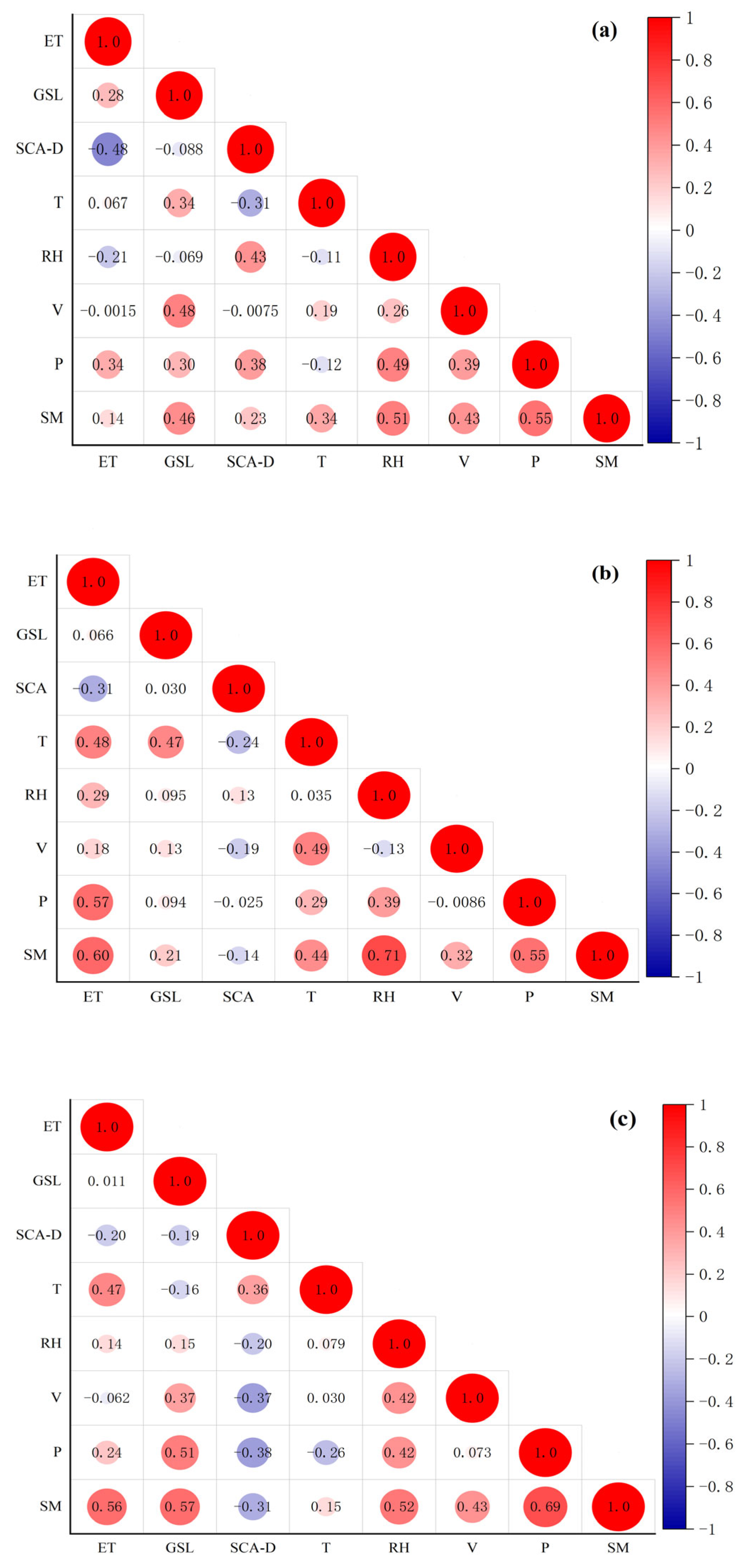
3.3.3. Impact of Meteorological Environmental Factors on Evapotranspiration

The climate conditions of the Qilian Mountains have a significant impact on ET. To better understand these conditions, we chose to focus on several environmental meteorological factors, including annual average temperature (T), annual average wind speed (V), annual precipitation (P), annual relative humidity (RH), and soil moisture (SM). By analyzing these factors, we estimated their individual impact on ET.
Figure 7 displays the ET variations resulting from alterations in environmental and meteorological factors in various regions. Soil moisture is a crucial element influencing ET [38], and various factors control the correlation between the two [39]. According to a study, the connection between soil moisture and ET is most robust in arid and semi-arid regions, where humidity limits ET. Conversely, there is a weak correlation between soil moisture and ET in regions where ET is mainly limited by energy, like tropical rainforests and areas at high latitudes [40]. ET in the Qilian Mountains is greatly affected by soil moisture, and the increase in soil moisture in the eastern, central, and western sections changes ET by 45–60%.
The temperature, precipitation, and wind speed increased the ET by 6.7%, 2.8%, and 8.4% in the eastern part, respectively. The wind speed and temperature were the primary drivers for increasing regional surface ET. Relative humidity had no noticeable effect on ET. In the western Qilian Mountains, temperature change had no insignificant effect on ET. Precipitation, wind speed, and relative humidity raised ET by 6.5%, 9.3%, and 16.2%, respectively. Therefore, the primary drivers for increasing regional surface ET are relative humidity and wind speed. Specifically, in the central Qilian Mountains, changes in temperature, precipitation, wind speed, and humidity increased the ET by 5.1%, 5.9%, 10.3%, and 11.5%, respectively. The ET changes were driven by multiple meteorological factors in this subzone.
Generally, the Qilian Mountains have varying climates across their eastern, western, and central sections. The eastern area experiences alpine and humid weather, while the western area has alpine and semi-arid weather. The central area is a transitional zone for climate types. The environmental meteorological factors also vary greatly and affect ET in this region. In summary, dynamic effects influence ET in different areas of the Qilian Mountains. Moisture mainly affects ET changes in the western section, while thermal effects control changes in the eastern section. Also, thermal effects control the central section, coordinated with moisture factors.
When analyzing the driving factors of surface ET change in the Qilian Mountains, the influence of the ecological environment should be taken into account, such as the length of the vegetation growing season and the melting of glacier ice and snow.
The growing season length (GSL) in the eastern section was 232.4 days, with a growth rate of 3.4 days/a; the average GSL in the middle section was 191.1 days, with a growth rate of 0.7 days/a; and the average GSL in the western section was 97.9 days, with a growth rate of 1.5 days/a.
The difference between winter and summer snow cover area (SCA-D) was 8102.3 km2 in the eastern section, 10,402.2 km2 in the middle section, and 13,835.2 km2 in the western section. The snow cover area in the western section in summer is obviously less than that in winter, and the snow cover is transformed into runoff, which reduces regional ET (Figure 8).
Through the correlation analysis of ET and the meteorological environment factors in the Qilian Mountains, we found that in the eastern section, precipitation, GSL, and SCA-D were the main controlling factors of ET change, and the Pearson correlation coefficients with ET were 0.34, 0.28, and −0.48, respectively; in the western section, SM, temperature, and precipitation were the main controlling factors of ET, and the Pearson correlation coefficients with ET were 0.56, 0.47, and 0.24, respectively; and in the middle section, SM, precipitation, temperature, RH, and SCA-D synergistically drive ET changes, and the Pearson correlation coefficients with ET were 0.6, 0.57, 0.48, 0.29, and −0.31, respectively (Figure 9). In summer, the glacier snow cover area decreases, inhibiting ET in the alpine mountains, and this phenomenon is most obvious in the eastern section.

4. Discussion

ET represents the key interaction between ecological and hydrological processes. Understanding the process and mechanism of evapotranspiration in different regions, multi-source observation errors and simulation errors, and the temporal and spatial distribution of evapotranspiration is of great importance for acquainting oneself with the evolution characteristics of the groundwater cycle, as well as its climate, resource, and environmental effects and the optimal management of water resources [41]. However, due to the lack of long-term reliable ET data previously, people’s understanding of surface ET changes in high mountain areas remains lacking.
With the development of emerging observation technologies and the continuous improvement of simulation capabilities, land ET research has developed rapidly, but there are still many unsolved problems and challenges to be solved, such as the complexity of surface ET observation and scale conversion, the spatiotemporal continuity and accuracy of remote sensing data, and land process model structures and parametric schemes, which limit the simulation accuracy of ET. The water balance method based on GRACE satellite data has the advantage of a simple principle, which is suitable for ET calculation at the large watershed scale or even the global scale, and can facilitate the accurate calculation of ET. However, using GRACE/GRACE-FO land water storage data and the water balance equation to estimate actual ET in high mountain areas, it is difficult to accurately reflect the replenishment effect of precipitation on the spatial water storage of glaciers, groundwater, soil, rivers, lakes, and reservoirs on a monthly scale, which will lead to abnormal ET calculation results. Therefore, abnormal data should be corrected to obtain high-quality ET results.
The influence of environmental and meteorological factors in different regions of the Qilian Mountains on ET changes requires more in-depth analysis, affected by multiple factors. In order to accurately quantify the multiple factors, better mathematical methods need to be adopted and the physical mechanisms need to be explained. The influencing factors of surface ET are very complicated. In addition to temperature, precipitation, wind speed, and atmospheric humidity, climate and environmental factors such as radiation, soil moisture, and vegetation state will affect the surface ET process to varying degrees [42]. Therefore, due to the effect of these factors, the research results of this paper show certain discreteness and bias, which will have a certain impact on the objective quantification of the analysis conclusions of this paper.

5. Conclusions

We estimated ET according to the principle of water balance. The differences in ET in different regions and the driving forces of the changes were expounded.
(1) We estimated the Qilian Mountains’ ET according to the water balance equation using GRACE/GRACE-FO satellite data. The results show good consistency with ETMonitor products. The correlation coefficient between the results and ETMonitor products at the monthly scale is 0.92, the NSE coefficient is 0.80, and the RMSE is 10.38 mm.
(2) In the context of new climate characteristics, the spatial distribution of the annual mean ET decreases from east to west in a “high–medium–low” pattern, but from the perspective of time change, the increase trend of ET shows a “medium–high–low” pattern from east to west, with an increase rate of 5.2 mm/a in the middle section, and the increase rate for ET was significantly higher. This is because, in the middle part of the Qilian Mountains, with an increase in temperature, the annual ET is increasing and the ET change is more sensitive to temperature.
(3) In spring, ET shows an increasing trend in most areas of the Qilian Mountains, and the maximum increase rate in the middle part is 1.3 mm/a; in summer, the maximum increase rate for ET changes from the middle part to the western part, the increase rate is 3.3 mm/a, and the increase rate is significant in the northwest part of the western region. In the western part of this region, the temperature in summer is higher, the precipitation increases, and the thermal effect and water factor dominate the regional ET changes. In autumn, ET decreased in the middle and western sections. Precipitation is concentrated in summer. The energy and water factors in the middle and western parts were significantly weaker than those in the eastern part, resulting in lower ET. In winter, the ET trend changes from decreasing to increasing in the middle section, but there is no obvious trend in the western section.
(4) The middle part is the transition zone from a highly cold humid climate to a highly cold semi-arid climate, and the change in ET is jointly affected by energy, water, and dynamic factors. Due to the obvious gradient characteristics of environmental meteorological factors, ET is greatly influenced by fluctuations in environmental meteorological factors, and a variety of environmental meteorological factors collaboratively drive ET changes in this region.

Author Contributions

Data curation, Formal analysis, and Writing-original draft, B.B.; Conceptualization, Methodology, and Writing-review and editing, P.Y.; Visualization and Investigation, X.R.; Supervision, review and editing, Q.Z.; Visualization and Validation, J.Z.; Conceptualization and Methodology, J.Y.; Conceptualization and Methodology, Y.J. All authors have read and agreed to the published version of the manuscript.

Funding

This research was supported by the National Natural Science Foundation of China (No. U2142208, 41975016, 42230611), Innovative Development Special Project of China Meteorological Administration (CXFZ2023J040), Gansu Provincial Natural Science Fund (20JR5RA121, 20JR10RA447) and Gansu Province Basic Research Innovation Group Project (23JRRA567).

Data Availability Statement

Data will be made available upon request.

Conflicts of Interest

The authors declare that they have no known competing financial interests or personal relationships that could have appeared to influence the work reported in this paper.

References

  1. Wang, K.; Dickinson, R.E. A review of global terrestrial evapotranspiration: Observation, modeling, climatology, and climatic variability. Rev. Geophys. 2012, 50, RG2005. [Google Scholar] [CrossRef]
  2. Miralles, D.G.; Brutsaert, W.; Dolman, A.J.; Gash, J.H. On the use of the term ‘Evapotranspiration’. Water Resour. Res. 2020, 56, e2020WR028055. [Google Scholar] [CrossRef] [PubMed]
  3. Oki, T.; Kanae, S. Global hydrological cycles and world water resources. Science 2006, 313, 1068–1072. [Google Scholar] [CrossRef] [PubMed]
  4. Huntington, T.G. Evidence for intensification of the global water cycle: Review and synthesis. J. Hydrometeorol. 2006, 319, 83–95. [Google Scholar] [CrossRef]
  5. Greve, P.; Orlowsky, B.; Mueller, B.; Sheffield, J.; Reichstein, M.; Seneviratne, S.I. Global assessment of trends in wetting and drying over land. Nat. Geosci. 2014, 7, 716–721. [Google Scholar] [CrossRef]
  6. Allan, R.P.; Barlow, M.; Byrne, M.P.; Cherchi, A.; Douville, H.; Fowler, H.J.; Gan, T.Y.; Pendergrass, A.G.; Rosenfeld, D.; Swann, A.L.S.; et al. Advances in understanding large-scale responses of the water cycle to climate change. Ann. N. Y. Acad. Sci. 2020, 1472, 14337. [Google Scholar] [CrossRef] [PubMed]
  7. Milly, P.C.D.; Dunne, K.A. Potential evapotranspiration and continental drying. Nat. Clim. Change 2016, 6, 946–950. [Google Scholar] [CrossRef]
  8. Yao, T.D.; Wu, F.Y.; Ding, L.; Sun, J.M.; Zhu, L.P.; Piao, S.L.; Deng, T.; Ni, X.J.; Zheng, H.B.; Ou, Y.H. Multispherical interactions and their effects on the Tibetan Plateau’s earth system: A review of the recent researches. Natl. Sci. Rev. 2015, 2, 468–488. [Google Scholar] [CrossRef]
  9. Wang, Y.H.; Li, D.H.; Lu, G.Y.; Jiang, Y.Y.; Huang, P.C. Characteristics of climate change and its impacts on water resources in Qilian Mountains, China. Chin. J. Appl. Ecol. 2022, 33, 2805–2812. [Google Scholar]
  10. Han, L.J.; Bai, A.J.; Pu, X.M. Projection of Climate Variation in Qilian Mountains Based on CMIP6. Plateau Meteorol. 2022, 41, 864–875. [Google Scholar]
  11. Kang, S.C.; Xu, Y.W.; You, Q.L.; Flügel, W.-A.; Pepin, N.; Yao, T.D. Review of climate and cryospheric change in the Tibetan Plateau. Environ. Res. Lett. 2010, 5, 015101. [Google Scholar] [CrossRef]
  12. Cheng, P.; Kong, X.W.; Luo, H. Climate change and its runoff response in the middle section of the Qilian Mountains in the past 60 years. Arid Land Geogr. 2020, 43, 1192–1201. [Google Scholar]
  13. Lin, P.; He, Z.; Du, J.; Chen, L.F.; Zhu, X.; Li, J. Impacts of climate change on reference evapotranspiration in the Qilian Mountains of China: Historical trends and projected changes. Int. J. Climatol. 2018, 38, 2980–2993. [Google Scholar] [CrossRef]
  14. Sun, X.M.; Zhu, Z.L.; Wen, X.F.; Yuan, G.F.; Yu, G.R. The impact of averaging period on eddy fluxes observed at China FLUX sites. Agric. For. Meteorol. 2006, 137, 188–193. [Google Scholar] [CrossRef]
  15. Arendt, A.A.; Luthcke, S.B.; Larsen, C.F.; Abdalati, W.; Krabill, W.B.; Beedle, M.J. Validation of high-resolution GRACE mascon estimates of glacier mass changes in the St. Elias Mountains, Alaska, USA, using aircraft laser altimetry. J. Glaciol. 2008, 54, 778–787. [Google Scholar] [CrossRef]
  16. Scanlon, B.R.; Zhang, Z.Z.; Save, H.; Sun, A.Y.; Müller Schmied, H.; van Beek, L.P.H.; Wiese, D.N.; Wada, Y.; Long, D.; Reedy, R.C.; et al. Global models underestimate large decadal declining and rising water storage trends relative to GRACE satellite data. Proc. Natl. Acad. Sci. USA 2018, 115, E1080–E1089. [Google Scholar] [CrossRef] [PubMed]
  17. Cao, Y.P.; Nan, Z.T.; Cheng, G.D. GRACE Gravity Satellite Observations of Terrestrial Water Storage Changes for Drought Characterization in the Arid Land of Northwestern China. Remote Sens. 2015, 7, 1021–1047. [Google Scholar] [CrossRef]
  18. Rodell, M.; Famiglietti, J.S.; Chen, J.; Seneviratne, S.I.; Viterbo, P.; Holl, S. Basin scale estimates of evapotranspiration using GRACE and other observations. Geophys. Res. Lett. 2004, 31, L20504. [Google Scholar] [CrossRef]
  19. Pascolini-Campbell, M.A.; Reager, J.T.; Fisher, J.B. GRACE-based Mass Conservation as a Validation Target for Basin-Scale Evapotranspiration in the Contiguous United States. Water Resour. Res. 2020, 56, e2019WR026594. [Google Scholar] [CrossRef]
  20. Yang, L.S.; Feng, Q.; Adamowski, J.F.; Alizadeh, M.R.; Yin, Z.L.; Wen, X.H.; Zhu, M. The role of climate change and vegetation greening on the variation of terrestrial evapotranspiration in northwest China’s Qilian Mountains. Sci. Total Environ. 2021, 759, 143532. [Google Scholar] [CrossRef]
  21. Bing, B.; Ping, Y.; Qiang, Z.; Jin, Y.; Peng, M.; Tao, H.; You, J.; Peng, H.; Yu, M. Changing characteristics of ecosystem and water storage under the background of warming and humidification in the Qilian Mountains, China. Sci. Total Environ. 2023, 893, 164959. [Google Scholar]
  22. Liu, H.; Yuan, X.; Zhang, M. Unraveling human influence on evapotranspiration over East Asian monsoon river basins by using GRACE/GRACE-FO data and land surface models. J. Hydrol. 2022, 605, 127349. [Google Scholar] [CrossRef]
  23. Zhong, Y.; Tian, B.; Vishwakarma, B.D.; Feng, W.; Wu, Y.; Bai, H.; Zhong, M. Reinterpreting Global GRACE Trends Based on Century-Long GRACE-REC Data. Water Resour. Res. 2023, 59, e2023WR035817. [Google Scholar] [CrossRef]
  24. Liao, M.; Zhang, X.; Huang, H.; Sun, X. Monitoring water storage changes in Dongting lake basin from GRACE gravity satellite. Prog. Geophys. 2016, 31, 61–68. (In Chinese) [Google Scholar]
  25. Landerer, F.W.; Flechtner, F.M.; Save, H.; Webb, F.H.; Bandikova, T.; Bertiger, W.I.; Yuan, D. Extending the global mass change data record: GRACE Follow-on instrument and science data performance. Geophys. Res. Lett. 2020, 47, e2020GL088306. [Google Scholar] [CrossRef]
  26. Zheng, C.; Jia, L.; Hu, G. Global Land Surface Evapotranspiration Monitoring by ETMonitor Model Driven by Multi-source Satellite Earth Observations. J. Hydrol. 2022, 613, 128444. [Google Scholar] [CrossRef]
  27. Zhang, J.T.; Zhang, C.Q.; Feng, Q. ERA5-Land Monthly Averaged Dataset in the Qilian Mountains from 1981 to 2020. National Cryosphere Desert Data Center. Available online: http://www.ncdc.ac.cn (accessed on 7 June 2023).
  28. Zhang, K.; Ju, Y.; Li, Z.J. Satellite-based reconstruction and spatiotemporal variability analysis of actual evapotranspiration in the Jinshajiang River basin. Adv. Water Sci. 2021, 32, 182–191. [Google Scholar]
  29. Billah, M.M.; Goodall, J.L.; Narayan, U.; Reager, J.T.; Lakshmi, V.; Famiglietti, J.S. A methodology for evaluating evapotranspiration estimates at the watershed-scale using GRACE. J. Hydrol. 2015, 523, 574–586. [Google Scholar] [CrossRef]
  30. Zeng, Z.; Piao, S.L.; Lin, X. Global evapotranspiration over the past three decades: Estimation based on the water balance equation combined with empirical models. Environ. Res. Lett. 2012, 7, 014026. [Google Scholar] [CrossRef]
  31. Xu, G.; Wu, Y.; Liu, S.; Cheng, S.; Zhang, Y.; Pan, Y.; Wang, L.; Yu, E. How 2022 extreme drought influences the spatiotemporal variations of terrestrial water storage in the Yangtze River Catchment: Insights from GRACE-based drought severity index and in situ measurements. J. Hydrol. 2023, 626, 130245. [Google Scholar] [CrossRef]
  32. Liu, S.; Wu, Y.; Xu, G.; Cheng, S.; Zhong, Y.; Zhang, Y. Characterizing the 2022 Extreme Drought Event over the Poyang Lake Basin Using Multiple Satellite Remote Sensing Observations and In Situ Data. Remote Sens. 2023, 15, 5125. [Google Scholar] [CrossRef]
  33. Ferreira, V.; Gong, Z.; He, X.F.; Zhang, Y.L.; Andam, S. Estimating Total Discharge in the Yangtze River Basin Using Satellite-Based Observations. Remote Sens. 2013, 5, 3415–3430. [Google Scholar] [CrossRef]
  34. Long, D.; Longuevergne, L.; Scanlon, B.R. Uncertainty in evapotranspiration from land surface modeling, remote sensing and GRACE satellites. Water Resour. Res. 2014, 50, 1131–1151. [Google Scholar] [CrossRef]
  35. Kendall, M.G. A new measure of rank correlation. Biometrika 1938, 30, 81–93. [Google Scholar] [CrossRef]
  36. Milentijević, N.; Bačević, N.; Ristić, D.; Valjarević, A.; Kićović, D. Application of Mann-Kendal (MK) test in trend analysis of air temperature and precipitation: Case of Mava district (Serbia). Bull. Nat. Sci. Res. 2020, 10, 37–43. [Google Scholar] [CrossRef]
  37. McCuen, R.H. A sensitivity and error analysis of procedures used for estimating evaporation. Water. Res. Bull 1974, 10, 486–498. [Google Scholar] [CrossRef]
  38. Fisher, R.A.; Williams, M.; Ruivo, M.D.; Costa, A.L.; Meir, P. Evaluating climatic and soil water controls on evapotranspiration at two Amazonian rainforest sites. Agric. For. Meteor 2008, 148, 850–861. [Google Scholar] [CrossRef]
  39. Husain, S.Z.; Béelair, S.; Leroyer, S. Influence of soil moisture on urban microclimate and surface-layer meteorology in Oklahoma City. J. Appl. Meteor. Clim. 2014, 53, 83–98. [Google Scholar] [CrossRef]
  40. Lawrence, D.M.; Slingo, J.M. Weak land-atmosphere coupling strength in HadAM3-The role of soil moisture variability. J. Hydrometeor 2005, 6, 670–680. [Google Scholar] [CrossRef]
  41. Yang, L.; Feng, Q.; Yin, Z. Regional hydrology heterogeneity and the response to climate and land surface changes in arid alpine basin, northwest China. Catena 2020, 187, 104345. [Google Scholar] [CrossRef]
  42. Xu, H.J.; Zhao, C.Y.; Wang, X.P. Spatiotemporal differentiation of the terrestrial gross primary production response to climate constraints in a dryland mountain ecosystem of northwestern China. Agric. For. Meteorol. 2019, 276, 107628. [Google Scholar] [CrossRef]
Figure 1. The landform of Qilian Mountains and inland rivers. I: western section; II: middle section; III: eastern section.
Remotesensing 16 01877 g001
Figure 2. Comparison of ETGRACE and ETMonitor in the Qilian Mountains from 2003 to 2019. (a) Monthly scale; (b) seasonal scale; (c) annual scale; (d) monthly data accuracy testing.
Remotesensing 16 01877 g002
Figure 3. Spatial distribution of annual ET and change trend in different regions of the Qilian Mountains (the shaded part of the curve and dotted areas are the region that passed the 0.05 significance test). I: western section; II: middle section; III: eastern section.
Remotesensing 16 01877 g003
Figure 4. Inter−annual variation of average temperature (a) and precipitation (b) trends in the Qilian Mountains.
Remotesensing 16 01877 g004
Figure 5. Variation in annual mean ET with temperature increase in different regions of the Qilian Mountains.
Remotesensing 16 01877 g005
Figure 6. Seasonal variation and spatial distribution of ET in different regions of the Qilian Mountains (dashed lines are trend lines and the dotted areas are the region that passed the 0.05 significance test). I: western section; II: middle section; III: eastern section.
Remotesensing 16 01877 g006aRemotesensing 16 01877 g006b
Figure 7. Relative changes in ET induced by each environment factor in different regions of the Qilian Mountains from 2003 to 2019.
Remotesensing 16 01877 g007
Figure 8. The length of the vegetation growth season and the difference between winter and summer snow cover in the Qilian Mountains. (a) Eastern section; (b) middle section; (c) western section.
Remotesensing 16 01877 g008
Figure 9. Heat map of ET and meteorological environmental factors. (a) Eastern section; (b) middle section; (c) western section.
Remotesensing 16 01877 g009
Table 1. The evaluation merits (PCC, MRE, and RMSE mm−1) on monthly PPT for the Qilian Mountains by using different products.
Site NamePPTPCCMRE/%RMSE/mm
TuoleERA50.9434.512.88
GPCC0.8936.216.38
MPDC0.8735.218.08
QilianERA50.8342.223.06
GPCC0.8235.623.86
MPDC0.7936.225.40
MenyuanERA50.9336.417.08
GPCC0.8834.720.94
MPDC0.8532.124.02
HuangyuanERA50.9325.115.14
GPCC0.9322.814.07
MPDC0.9126.216.20
Disclaimer/Publisher’s Note: The statements, opinions and data contained in all publications are solely those of the individual author(s) and contributor(s) and not of MDPI and/or the editor(s). MDPI and/or the editor(s) disclaim responsibility for any injury to people or property resulting from any ideas, methods, instructions or products referred to in the content.

