Effects of the Architectural Layout of the Sanctuary of Pachacamac (2nd–16th Century CE, Peru) on the Exposure to Rain, Wind, and Solar Radiation from the Morphometric Analysis of Digital Surface Models
Abstract
1. Introduction
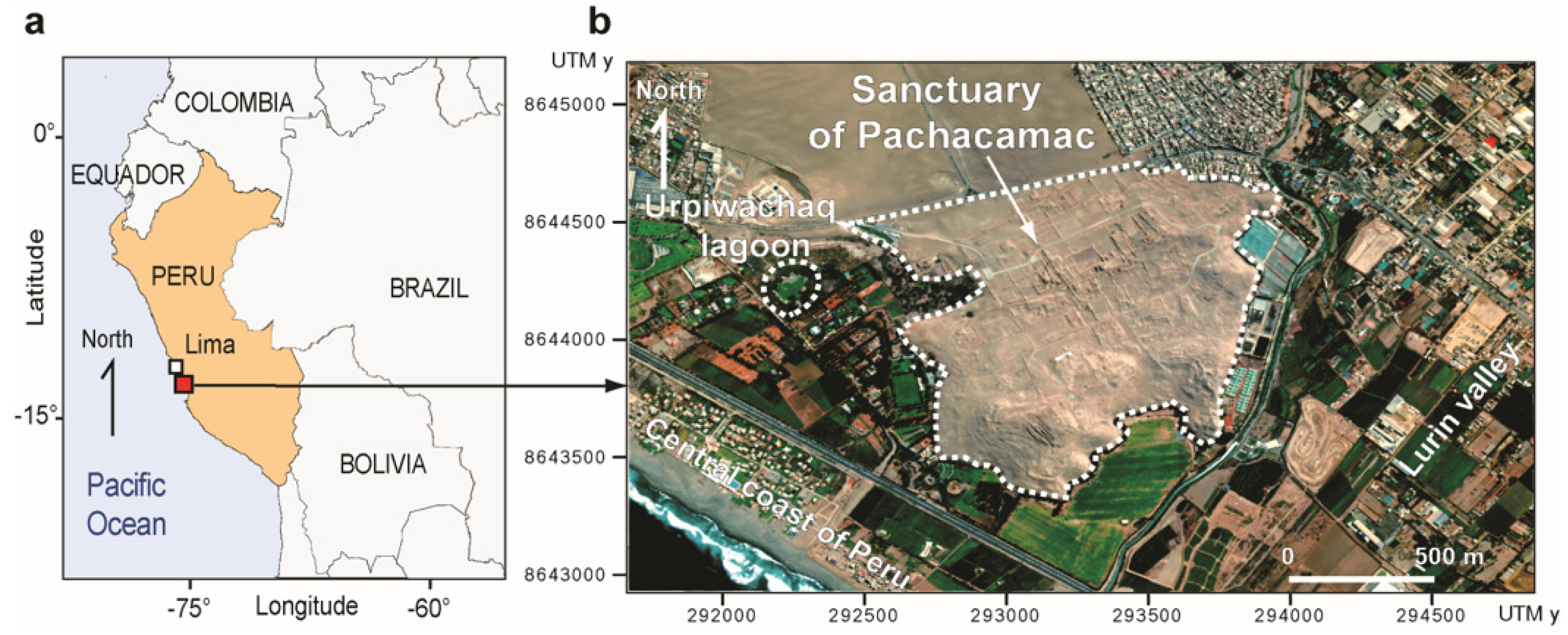
2. Sanctuary of Pachacamac
2.1. Terrain Morphology and Main Structures
2.2. History
2.3. Environmental Conditions
2.4. Damages
3. Materials and Methods
3.1. Orthophotogrammetric Survey and DSM
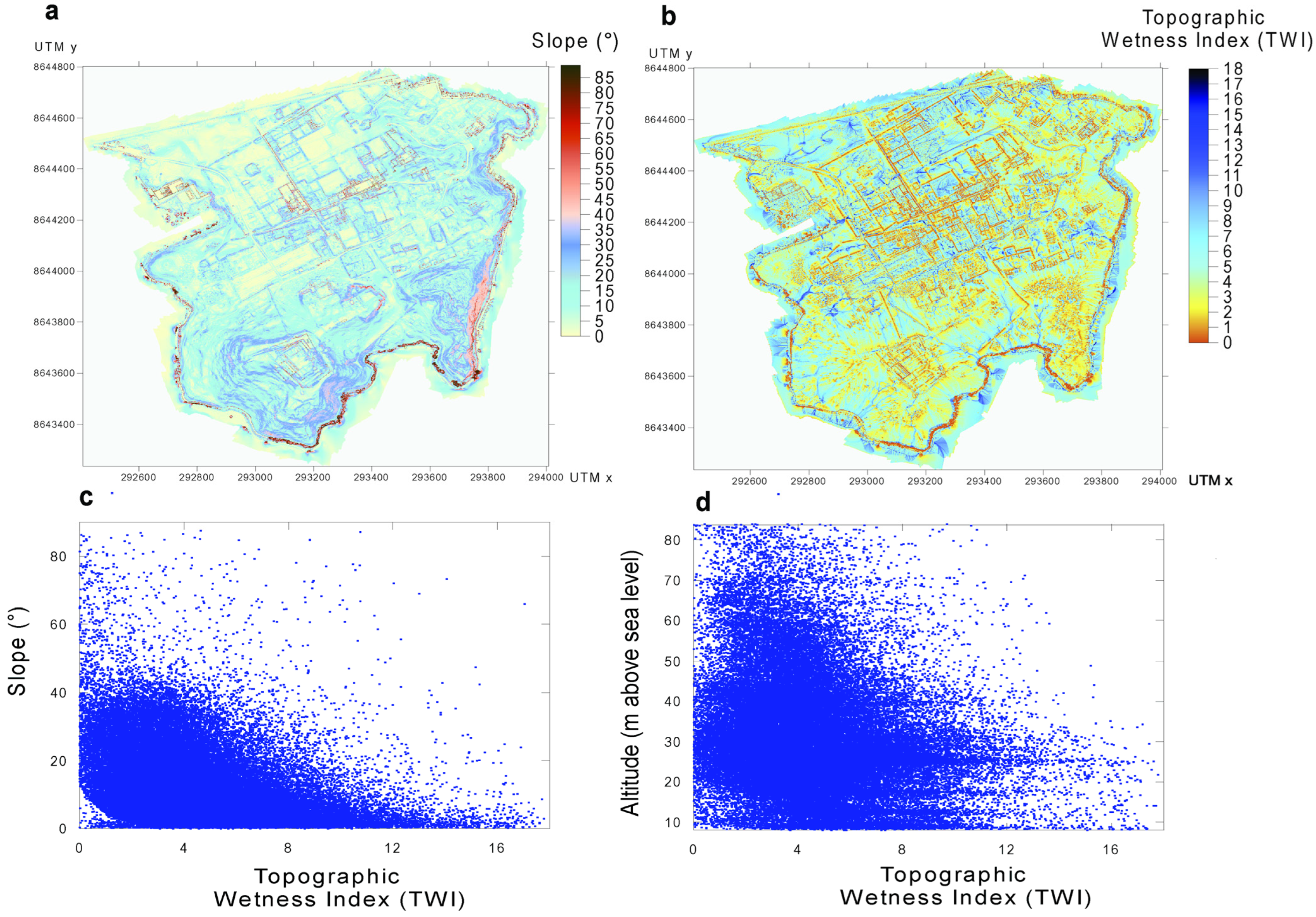
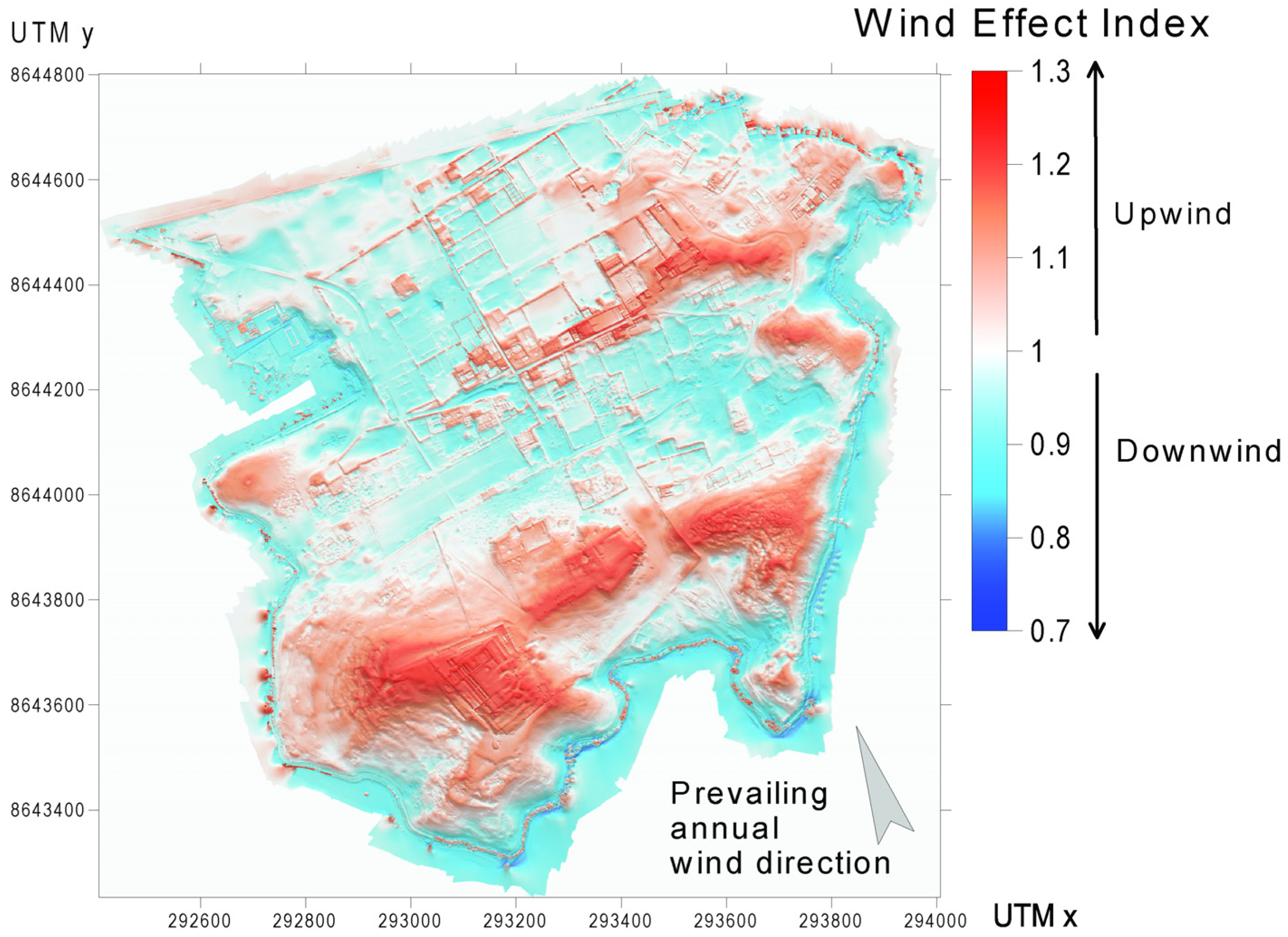
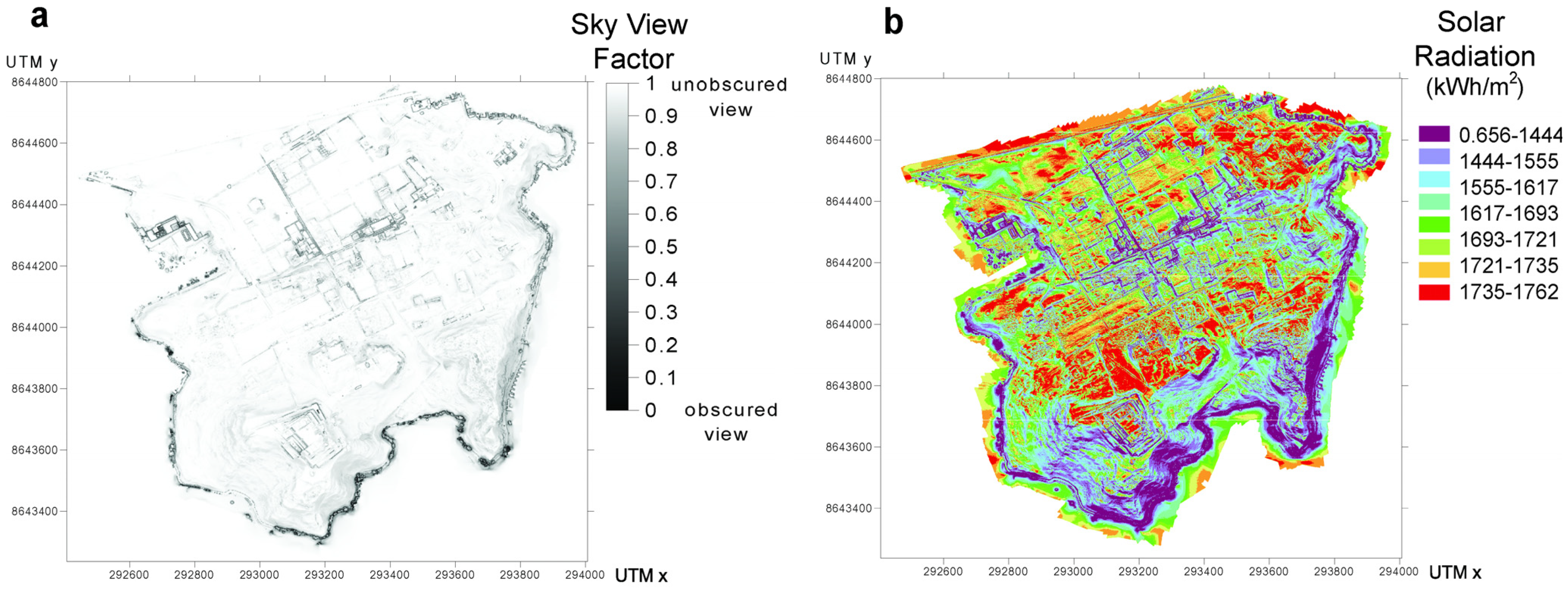
3.2. Morphometric Analysis and Parameters
- (a)
- Water flow or stagnation during the rainfalls related to forthcoming El Niño episodes with the caveat that the intensity of heavy rainfall episodes is very difficult to predict [58].
- (b)
- Wind coming off the sea level [59] given that TS is located 1 km northwest of the central coast of Peru.
- (c)
- Direct incoming solar radiation as experienced in the semi-arid climatic conditions of the central coastal area of Peru [60].
4. Results
5. Discussion
6. Conclusions
- (a)
- DSMs of archaeological sites may be used to define the areas and structures subjected to potential damage from climatic/meteorological events.
- (b)
- Object-based image analysis provides a critical tool for evaluating the combined contribution of multiple risk exposures and identifying the areas which are subject to major environmental and climatic threats.
- (c)
- The degree to which archaeological sites are exposed to rainwater flow or stagnation, winds, and solar radiation may be obtained based on the combined analysis of DSMs, morphometric parameters, and climatic/meteorological data.
- (d)
- The degree of exposure of the SP architectural structures of particular archaeological interest to the above-reported natural phenomena is quantified.
- (e)
- The architectural layout of archaeological sites plays a major role in controlling the spatial distribution of the areas subjected to water flow or stagnation, whereas the exposure to winds and solar radiation and winds is manly controlled by the topographic elements as hills and plains.
- (f)
- At SP, the tourist routes may act as channels during heavy rain, whereas the walls of the main constructions act as a watershed and delimit the areas where the water may stagnate.
Author Contributions
Funding
Data Availability Statement
Acknowledgments
Conflicts of Interest
References
- Kintigh, K.W.; Altschul, J.H.; Beaudry, M.C.; Drennan, R.D.; Kinzig, A.P.; Kohler, T.A.; Limp, W.F.; Maschner, H.D.G.; Michener, W.K.; Pauketat, T.R.; et al. Grand Challenges for Archaeology. Am. Antiq. 2014, 79, 5–24. [Google Scholar] [CrossRef]
- Xiao, W.; Mills, J.; Guidi, G.; Rodríguez-Gonzálvez, P.; Gonizzi Barsanti, S.; González-Aguilera, D. Geoinformatics for the Conservation and Promotion of Cultural Heritage in Support of the UN Sustainable Development Goals. ISPRS J. Photogramm. Remote Sens. 2018, 142, 389–406. [Google Scholar] [CrossRef]
- Nations, U. Transforming Our World: The 2030 Agenda for Sustainable Development; United Nations, Department of Economic and Social Affairs: New York, NY, USA, 2015. [Google Scholar]
- Cunliffe, E. Archaeological Site Damage in the Cycle of War and Peace: A Syrian Case Study. J. East. Mediterr. Archaeol. Herit. Stud. 2014, 2, 229–247. [Google Scholar] [CrossRef]
- Darvill, T.; Wainwright, G. The Monuments at Risk Survey: An Introduction. Antiquity 1994, 68, 820–824. [Google Scholar] [CrossRef]
- Blaikie, P.; Cannon, T.; Davis, I.; Wisner, B. At Risk. Natural Hazards, People’s Vulnerability and Disasters; Routledge: London, UK, 2014; ISBN 9781135642723. [Google Scholar]
- Ravankhah, M.; de Wit, R.; Argyriou, A.V.; Chliaoutakis, A.; Revez, M.J.; Birkmann, J.; Žuvela-Aloise, M.; Sarris, A.; Tzigounaki, A.; Giapitsoglou, K. Integrated Assessment of Natural Hazards, Including Climate Change’s Influences, for Cultural Heritage Sites: The Case of the Historic Centre of Rethymno in Greece. Int. J. Disaster Risk Sci. 2019, 10, 343–361. [Google Scholar] [CrossRef]
- Smith, K.; Fearnley, C.J.; Dixon, D.; Bird, D.K.; Kelman, I. Environmental Hazards; Routledge: London, UK, 2023; ISBN 9781351261647. [Google Scholar]
- Contreras, D.A.; Brodie, N. The Utility of Publicly-Available Satellite Imagery for Investigating Looting of Archaeological Sites in Jordan. J. Field Archaeol. 2010, 35, 101–114. [Google Scholar] [CrossRef]
- Evans, D.H.; Fletcher, R.J.; Pottier, C.; Chevance, J.-B.; Soutif, D.; Tan, B.S.; Im, S.; Ea, D.; Tin, T.; Kim, S.; et al. Uncovering Archaeological Landscapes at Angkor Using Lidar. Proc. Natl. Acad. Sci. USA 2013, 110, 12595–12600. [Google Scholar] [CrossRef]
- Fisher, C.T.; Cohen, A.S.; Fernández-Diaz, J.C.; Leisz, S.J. The Application of Airborne Mapping LiDAR for the Documentation of Ancient Cities and Regions in Tropical Regions. Quat. Int. 2017, 448, 129–138. [Google Scholar] [CrossRef]
- Kincey, M.; Gerrard, C.; Warburton, J. Quantifying Erosion of ‘at Risk’ Archaeological Sites Using Repeat Terrestrial Laser Scanning. J. Archaeol. Sci. Rep. 2017, 12, 405–424. [Google Scholar] [CrossRef]
- Inomata, T.; Triadan, D.; Pinzón, F.; Burham, M.; Ranchos, J.L.; Aoyama, K.; Haraguchi, T. Archaeological Application of Airborne LiDAR to Examine Social Changes in the Ceibal Region of the Maya Lowlands. PLoS ONE 2018, 13, e0191619. [Google Scholar] [CrossRef]
- Risbøl, O.; Gustavsen, L. LiDAR from Drones Employed for Mapping Archaeology—Potential, Benefits and Challenges. Archaeol. Prospect. 2018, 25, 329–338. [Google Scholar] [CrossRef]
- Garrison, T.G.; Houston, S.; Alcover Firpi, O. Recentering the Rural: Lidar and Articulated Landscapes among the Maya. J. Anthropol. Archaeol. 2019, 53, 133–146. [Google Scholar] [CrossRef]
- Magnini, L.; Bettineschi, C. Object-Based Predictive Modeling (OBPM) for Archaeology: Finding Control Places in Mountainous Environments. Remote Sens. 2021, 13, 1197. [Google Scholar] [CrossRef]
- Bettineschi, C.; Magnini, L.; Azzalin, G.; De Guio, A. Clearence Cairnfields Forever: Combining AI and LiDAR Data in the Marcesina Upland (Northern Italy). Eur. J. Postclassical Archaeol. 2022, 12, 49–68. [Google Scholar]
- Magnini, L.; De Guio, A.; Bettineschi, C. Remote Sensing and Artificial Intelligence for Mountain Archaeology. In The Oxford Handbook of Mountain Archaeology; Oxford University Press: Oxford, UK, 2024. [Google Scholar]
- Beven, K.J.; Kirkby, M.J. A Physically Based, Variable Contributing Area Model of Basin Hydrology/Un Modèle à Base Physique de Zone d’appel Variable de l’hydrologie Du Bassin Versant. Hydrol. Sci. Bull. 1979, 24, 43–69. [Google Scholar] [CrossRef]
- Marsh, A.; Fleitmann, D.; Al-Manmi, D.A.M.; Altaweel, M.; Wengrow, D.; Carter, R. Mid- to Late-Holocene Archaeology, Environment and Climate in the Northeast Kurdistan Region of Iraq. Holocene 2018, 28, 955–967. [Google Scholar] [CrossRef]
- Agapiou, A.; Lysandrou, V.; Hadjimitsis, D.G. A European-Scale Investigation of Soil Erosion Threat to Subsurface Archaeological Remains. Remote Sens. 2020, 12, 675. [Google Scholar] [CrossRef]
- Guiney, R.; Santucci, E.; Valman, S.; Booth, A.; Birley, A.; Haynes, I.; Marsh, S.; Mills, J. Integration and Analysis of Multi-Modal Geospatial Secondary Data to Inform Management of at-Risk Archaeological Sites. ISPRS Int. J. Geo-Inf. 2021, 10, 575. [Google Scholar] [CrossRef]
- Papageorgiou, N.; Hadjimitsis, D.G. Evaluation of Soil Loss by Water in Archaeological Landscapes by Using the (R)USLE Model and GIS. The Case Study of Paphos District, Cyprus. In Digital Heritage. Progress in Cultural Heritage: Documentation, Preservation, and Protection: 8th International Conference, EuroMed 2020, Virtual Event, 2–5 November 2020, Revised Selected Papers 8; Springer: Berlin/Heidelberg, Germany, 2021; pp. 64–77. [Google Scholar]
- Forti, L.; Brandolini, F.; Oselini, V.; Peyronel, L.; Pezzotta, A.; Vacca, A.; Zerboni, A. Geomorphological Assessment of the Preservation of Archaeological Tell Sites. Sci. Rep. 2023, 13, 7683. [Google Scholar] [CrossRef]
- Apa, M.I.P.; La Torre, C.E.W.; Cachay, R.F.G.; Magnini, L.; Murga, J.C.; Ranera, F.; Ventura, G. Quantitative Estimate of the Damages from Human Activities at the Apurlec Monumental Archaeological Complex (7th–14th Century AD, Peru) from Multitemporal Photogrammetry. Archaeol. Anthropol. Sci. 2023, 15, 110. [Google Scholar] [CrossRef]
- Sandweiss, D.H.; Maasch, K.A.; Burger, R.L.; Richardson, J.B.; Rollins, H.B.; Clement, A. Variation in Holocene El Niño Frequencies: Climate Records and Cultural Consequences in Ancient Peru. Geology 2001, 29, 603. [Google Scholar] [CrossRef]
- Delle Rose, M. Landscape Modifications Ascribed to El Niño Events in Late Pre-Hispanic Coastal Peru. Land 2022, 11, 2207. [Google Scholar] [CrossRef]
- Franco, R.; Paredes, P. El Templo Viejo de Pachacamac: Nuevos Aportes Al Estudio Del Horizonte Medio. Boletín Arqueol. PUCP 2000, 4, 607–630. [Google Scholar] [CrossRef]
- Winsborough, B.M.; Shimada, I.; Newsom, L.A.; Jones, J.G.; Segura, R.A. Paleoenvironmental Catastrophies on the Peruvian Coast Revealed in Lagoon Sediment Cores from Pachacamac. J. Archaeol. Sci. 2012, 39, 602–614. [Google Scholar] [CrossRef]
- Vieira, M.T.; Vieira, A.V.; García, C.M.V. Vulnerability Index Elaboration for Climate Change Adaptation in Peru. Eur. J. Sustain. Dev. 2019, 8, 102. [Google Scholar] [CrossRef]
- L’Heureux, M.L.; Tippett, M.K.; Takahashi, K.; Barnston, A.G.; Becker, E.J.; Bell, G.D.; Di Liberto, T.E.; Gottschalck, J.; Halpert, M.S.; Hu, Z.-Z.; et al. Strength Outlooks for the El Niño–Southern Oscillation. Weather Forecast. 2019, 34, 165–175. [Google Scholar] [CrossRef]
- Zschau, J. Where Are We with Multihazards, Multirisks Assessment Capacities? In Science for Disaster Risk Management 2017: Knowing Better and Losing Less; Poljanšek, K., Marín Ferrer, M., De Groeve, T., Clark, I., Eds.; European Commission: Luxembourg, 2017; pp. 96–128. [Google Scholar]
- Appiotti, F.; Assumma, V.; Bottero, M.; Campostrini, P.; Datola, G.; Lombardi, P.; Rinaldi, E. Definition of a Risk Assessment Model within a European Interoperable Database Platform (EID) for Cultural Heritage. J. Cult. Herit. 2020, 46, 268–277. [Google Scholar] [CrossRef]
- Davis, D.S. Object-based Image Analysis: A Review of Developments and Future Directions of Automated Feature Detection in Landscape Archaeology. Archaeol. Prospect. 2019, 26, 155–163. [Google Scholar] [CrossRef]
- Blaschke, T. Object Based Image Analysis for Remote Sensing. ISPRS J. Photogramm. Remote Sens. 2010, 65, 2–16. [Google Scholar] [CrossRef]
- Magnini, L.; Bettineschi, C. Theory and Practice for an Object-Based Approach in Archaeological Remote Sensing. J. Archaeol. Sci. 2019, 107, 10–22. [Google Scholar] [CrossRef]
- Perales Munguía, M.F.; Capriata Estrada, C.; Hidalgo Villanueva, J.P. Historia y Uso Del Camino Entre Xauxa y Pachacamac: Investigaciones Arqueológicas e Históricas; Ministerio de Cultura del Peru: Lima, Peru, 2019.
- Cieza de Leon, P. de Crónica Del Perú. Segunda Parte. In Edición de Francesca Cantú; Fondo Editorial de la Pontificia Universidad Catolica del Perù—Academia Nacional de la Historia: Lima, Peru.
- Hyslop, J. Qhapaqñan. El Sistema Vial Inkaico; Mujica Barreda, E., Ed.; Instituto Andino de Estudios Arqueológicos (INDEA)—Petróleos del Perú: Lima, Peru, 1992; 119p. [Google Scholar]
- Estete, M. de Noticia Del Perú (Vol. I). In El Peru a Traves de Los Siglos; Editores Tecnicos Asociados Lima: Lima, Peru; pp. 345–402.
- Millones Santa Gadea, L. La Mirada de Los Conquistadores. In Pachacamac: El Oráculo en el Horizonte Marino del Sol Poniente; Banco de Crédito del Perù: Lima, Peru, 2017; pp. 34–47. ISBN 978-9972-837-30-2. [Google Scholar]
- Pozzi-Escot, D. Pachacamac: El Oráculo en el Horizonte Marino del Sol Poniente; Banco de Crédito del Perù: Lima, Peru, 2017. [Google Scholar]
- Makowski, K. Pachacamac y La Política Imperial Inca. In El Inca y la Huaca. La Religión del Poder y el Poder de la Religión en el Mundo Antiguo; Curatola, M., Szemiński, J., Eds.; The Hebrew University of Jerusalem y Fondo Editorial PUCP: Lima, Peru, 2016; pp. 153–208. [Google Scholar]
- Jiménez, C. Proyecto de Investigación y Conservación Del Templo Del Sol—Pachacamac; Fondo Editorial del BCP: Lima, Peru, 2011. [Google Scholar]
- Franco Jordán, R.G.; Paredes Botoni, P.F. Templo Viejo de Pachacamac. Dioses, Arquitectura, Sacrificios y Ofrendas; Institute of Andean Research-Fundación Wiesse: Lima, Peru, 2016; ISBN 9789972293795. [Google Scholar]
- Uhle, M. Pachacamac. Report of the William Pepper M.D., LL.D. Peruvian Expedition of 1896; University of Pennsylvania Press: Philadelphia, PA, USA, 1903. [Google Scholar]
- Ángeles; Rommel; Pozzi-Escot, D. El Horizonte Medio En Pachacamac. In Arqueología en el Perú. Nuevos Aportes para el Estudio de las Sociedades Andinas Prehispánicas; Romero, R., Pavel Svendsen, T., Eds.; Anheb Impresiones: Lima, Peru, 2010; pp. 175–196. [Google Scholar]
- Eeckhout, P. El Oráculo de Pachacamac y Los Peregrinajes a Larga Escala En Los Andes Prehispánicos. In Adivinación y Oráculos en las Américas; Curatola, M., Ziołkowsi, M., Eds.; Pontificia Universidad Católica del Perú, Instituto Francés de Estudios Andinos: Lima, Peru, 2008; pp. 161–180. [Google Scholar]
- Rostworowski, M. Pachacamac y El Señor de Los Milagros. Una Trayectoria Milenaria; Instituto de Estudios Peruanos: Lima, Peru, 1992. [Google Scholar]
- Tello, J.C. Pachacamac. Chaski 1940, 1, 1–4. [Google Scholar]
- Tello, J.C. Memoria Sucinta Sobre Los Trabajos Arqueológicos Realizados En Las Ruinas de Pachacámac Durante Los Años 1940 y 1941; Congreso Nacional de Arqueologia: Lima, Peru, 1943. [Google Scholar]
- Jacay, J.; Oshiro, J. Estudio Geológico de La Laguna Urpiwachaq. In Urpiwachaq: Gestión y Puesta en Valor de la Laguna; Pozzi-Escot, D., Oshiro, J., Eds.; Ministerio de Cultura del Perú y Universidad del Pacifico: Lima, Peru, 2015; pp. 21–37. [Google Scholar]
- Pozzi-Escot, D.; Oshiro, J.; Romano, G.; Capozzoli, L.; Lasaponara, R.; Masini, N. Traces in the Desert: Use of New Technologies for the Study and Valorization of the Pachacamac Sanctuary—Lima, Peru. Herit. Sci. 2018, 6, 68. [Google Scholar] [CrossRef]
- Shimada, I.; Segura, R.; Rostworowski; María Hirokatsu, W. Las Prospecciones y Excavaciones En Urpi Kocha y Urpi Wachaq: Estudio Preliminar. In Cuadernos de Investigación del Archivo Tello N°5. Arqueología de Pachacamac: Excavaciones en Urpi Kocha y Urpi Wachac, Editado por R. Vega-Centeno; Museo de Arqueología y Antropología y Universidad Nacional Mayor de San Marcos: Lima, Peru, 2007; pp. 13–18. [Google Scholar]
- Rostworowski, M. Recursos Naturales y Pesca, Siglos XVI-XVII/Curacas y Sucesiones, Costa Norte. Obras Completas IV; IEP: Lima, Peru, 2005. [Google Scholar]
- Cappai, M.; Delogu, F.; Pozzi-Escot, D.; Pacheco Neyra, G.; Meloni, P.; Pia, G. Degradation Phenomena of Templo Pintado Painted Plasters. Constr. Build. Mater. 2023, 392, 131839. [Google Scholar] [CrossRef]
- Chipana, H.; Abad, J.; Pozzi-Escot, D. Pachacamac: Levantamiento Arquitectónico Con Drone Del Santuario Arqueológico; Ministerio de Cultura: Lima, Peru, 2020.
- Lagos, P.; Silva, Y.; Nickl, E.; Mosquera, K. El Niño—Related Precipitation Variability in Perú. Adv. Geosci. 2008, 14, 231–237. [Google Scholar] [CrossRef]
- Goubanova, K.; Echevin, V.; Dewitte, B.; Codron, F.; Takahashi, K.; Terray, P.; Vrac, M. Statistical Downscaling of Sea-Surface Wind over the Peru–Chile Upwelling Region: Diagnosing the Impact of Climate Change from the IPSL-CM4 Model. Clim. Dyn. 2011, 36, 1365–1378. [Google Scholar] [CrossRef]
- Kottek, M.; Grieser, J.; Beck, C.; Rudolf, B.; Rubel, F. World Map of the Köppen-Geiger Climate Classification Updated. Meteorol. Zeitschrift 2006, 15, 259–263. [Google Scholar] [CrossRef] [PubMed]
- Kopecký, M.; Macek, M.; Wild, J. Topographic Wetness Index Calculation Guidelines Based on Measured Soil Moisture and Plant Species Composition. Sci. Total Environ. 2020, 757, 143785. [Google Scholar] [CrossRef] [PubMed]
- Pardo-Igúzquiza, E.; Dowd, P.A. The Mapping of Closed Depressions and Its Contribution to the Geodiversity Inventory. Int. J. Geoheritage Park. 2021, 9, 480–495. [Google Scholar] [CrossRef]
- Wang, L.; Liu, H. An Efficient Method for Identifying and Filling Surface Depressions in Digital Elevation Models for Hydrologic Analysis and Modelling. Int. J. Geogr. Inf. Sci. 2006, 20, 193–213. [Google Scholar] [CrossRef]
- Quinn, P.; Beven, K.; Chevallier, P.; Planchon, O. The Prediction of Hillslope Flow Paths for Distributed Hydrological Modelling Using Digital Terrain Models. Hydrol. Process. 1991, 5, 59–79. [Google Scholar] [CrossRef]
- Conrad, O.; Bechtel, B.; Bock, M.; Dietrich, H.; Fischer, E.; Gerlitz, L.; Wehberg, J.; Wichmann, V.; Böhner, J. System for Automated Geoscientific Analyses (SAGA) v. 2.1.4. Geosci. Model Dev. 2015, 8, 1991–2007. [Google Scholar] [CrossRef]
- Böhner, J.; Antonić, O. Chapter 8 Land-Surface Parameters Specific to Topo-Climatology. In Developments in Soil Science; Elsevier: Amsterdam, The Netherlands, 2009; pp. 195–226. [Google Scholar]
- Zakšek, K.; Oštir, K.; Kokalj, Ž. Sky-View Factor as a Relief Visualization Technique. Remote Sens. 2011, 3, 398–415. [Google Scholar] [CrossRef]
- Fu, P.; Rich, P.M. Design and Implementation of the Solar Analyst: An ArcView Extension for Modeling Solar Radiation at Landscape Scales. In Proceedings of the Nineteenth Annual ESRI User Conference, San Diego, CA, USA, 26–30 July 1999; pp. 1–31. [Google Scholar]
- Kidd, C.; Chapman, L. Derivation of Sky-View Factors from Lidar Data. Int. J. Remote Sens. 2012, 33, 3640–3652. [Google Scholar] [CrossRef]
- Blocken, B.; Carmeliet, J. A Review of Wind-Driven Rain Research in Building Science. J. Wind Eng. Ind. Aerodyn. 2004, 92, 1079–1130. [Google Scholar] [CrossRef]
- Brimblecombe, P.; Grossi, C.M. Damage to Buildings from Future Climate and Pollution. APT Bull. J. Preserv. Technol. 2007, 38, 13–18. [Google Scholar]
- Sesana, E.; Gagnon, A.S.; Ciantelli, C.; Cassar, J.; Hughes, J.J. Climate Change Impacts on Cultural Heritage: A Literature Review. WIREs Clim. Chang. 2021, 12, e710. [Google Scholar] [CrossRef]
- Park, K.; Won, J. Analysis on Distribution Characteristics of Building Use with Risk Zone Classification Based on Urban Flood Risk Assessment. Int. J. Disaster Risk Reduct. 2019, 38, 101192. [Google Scholar] [CrossRef]
- Azizi, K.; Diko, S.K.; Saija, L.; Zamani, M.G.; Meier, C.I. Integrated Community-Based Approaches to Urban Pluvial Flooding Research, Trends and Future Directions: A Review. Urban Clim. 2022, 44, 101237. [Google Scholar] [CrossRef]
- Zhu, Z.; Gou, L.; Liu, S.; Peng, D. Effect of Urban Neighbourhood Layout on the Flood Intrusion Rate of Residential Buildings and Associated Risk for Pedestrians. Sustain. Cities Soc. 2023, 92, 104485. [Google Scholar] [CrossRef]
- Argyrou, A.; Agapiou, A. A Review of Artificial Intelligence and Remote Sensing for Archaeo-logical Research. Remote Sens. 2022, 14, 6000. [Google Scholar] [CrossRef]


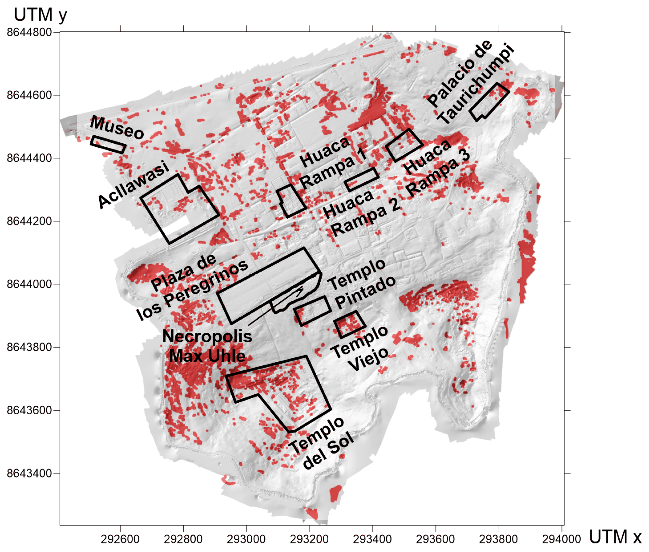
| Dating | Period | Culture (Coast of Peru) | Architecture |
|---|---|---|---|
| 1470 AD | Horizonte Tardío (Late Horizon Period) | Inca | Acllawasi (House of Sacred Weavers) Templo Del Sol (Temple of the Sun) Taurichumpi (Governor Palace) Building 47 Plaza de los Peregrinos (Pilgrims Square) House Of Quipus |
| 1100 AD | Intermedio Tardío (Late Intermediate Period) | Ychsma Chancay Casma | Huacas with ramps |
| 600 AD | Horizonte Medio (Middle Horizon Period) | Teatino Pachacamac Nievería | Templo Pintado (Painted Temple) Uhle Necropolis (Cementerio Uhle) |
| 0 AD | Intermedio Temprano (Early Intermediate Period) | Recuay Lima Miramar | Adobites Set (Little Mud Bricks) Urpiwachaq Temple Templo Viejo (Old Temple) |
Disclaimer/Publisher’s Note: The statements, opinions and data contained in all publications are solely those of the individual author(s) and contributor(s) and not of MDPI and/or the editor(s). MDPI and/or the editor(s) disclaim responsibility for any injury to people or property resulting from any ideas, methods, instructions or products referred to in the content. |
© 2024 by the authors. Licensee MDPI, Basel, Switzerland. This article is an open access article distributed under the terms and conditions of the Creative Commons Attribution (CC BY) license (https://creativecommons.org/licenses/by/4.0/).
Share and Cite
Magnini, L.; Pozzi-Escot, D.; Oshiro, J.; Angeles, R.; Apa, M.I.P.; Ventura, G. Effects of the Architectural Layout of the Sanctuary of Pachacamac (2nd–16th Century CE, Peru) on the Exposure to Rain, Wind, and Solar Radiation from the Morphometric Analysis of Digital Surface Models. Remote Sens. 2024, 16, 1848. https://doi.org/10.3390/rs16111848
Magnini L, Pozzi-Escot D, Oshiro J, Angeles R, Apa MIP, Ventura G. Effects of the Architectural Layout of the Sanctuary of Pachacamac (2nd–16th Century CE, Peru) on the Exposure to Rain, Wind, and Solar Radiation from the Morphometric Analysis of Digital Surface Models. Remote Sensing. 2024; 16(11):1848. https://doi.org/10.3390/rs16111848
Chicago/Turabian StyleMagnini, Luigi, Denise Pozzi-Escot, Janet Oshiro, Rommel Angeles, Maria Ilaria Panaccione Apa, and Guido Ventura. 2024. "Effects of the Architectural Layout of the Sanctuary of Pachacamac (2nd–16th Century CE, Peru) on the Exposure to Rain, Wind, and Solar Radiation from the Morphometric Analysis of Digital Surface Models" Remote Sensing 16, no. 11: 1848. https://doi.org/10.3390/rs16111848
APA StyleMagnini, L., Pozzi-Escot, D., Oshiro, J., Angeles, R., Apa, M. I. P., & Ventura, G. (2024). Effects of the Architectural Layout of the Sanctuary of Pachacamac (2nd–16th Century CE, Peru) on the Exposure to Rain, Wind, and Solar Radiation from the Morphometric Analysis of Digital Surface Models. Remote Sensing, 16(11), 1848. https://doi.org/10.3390/rs16111848


