Article

Response of the Stream Geomorphic Index to Fault Activity in the Lianfeng–Ningnan Segment (LNS) of the Lianfeng Fault on the Eastern Margin of the Tibetan Plateau

1
National Institute of Natural Hazards, Ministry of Emergency Management of China, Beijing 100085, China
2
State Key Laboratory of Earthquake Dynamics, Institute of Geology, China Earthquake Administration, Beijing 100029, China
3
Institute of Disaster Prevention, Sanhe 065201, China
*
Author to whom correspondence should be addressed.
Remote Sens. 2023, 15(9), 2309; https://doi.org/10.3390/rs15092309
Submission received: 24 March 2023 / Revised: 19 April 2023 / Accepted: 25 April 2023 / Published: 27 April 2023

Abstract

:
The response of the stream geomorphic index to fault activity is important for assessing the regional seismic hazard. The data used in this paper are 12 m resolution TanDEM-X data. The Fill tool in the Hydrology toolset in ArcGIS 10.5 was used to first process the digital elevation model (DEM), then analyse the flow direction of the DEM after filling and finally extract streams with catchment areas of more than 9 km2. Based on the DEM spatial analysis, the stream geomorphic index of the Lianfeng–Ningnan segment (LNS) of the Lianfeng fault was extracted, including the stream length gradient (SL) and the hypsometric integral (HI). This information, combined with the analysis of typical field geomorphology and terrace profiles, was used to define the fault activity period. To analyse the activity characteristics of the LNS, the LNS was divided into northern (Lianfeng to Jinyang), middle (Jinyang to Duiping town) and southern segments (Duiping town to Ningnan). The stream geomorphic index showed spatial variations, with mean SL and HI values of 384 and 0.45, respectively, in the northern segment; 175 and 0.41, respectively, in the middle segment; and 378 and 0.45, respectively, in the southern segment. These results indicate that the northern and southern segments of the LNS are more active than the middle segment, that there is little difference between the northern and southern segments, and that the activity of the middle segment is relatively weak. By comprehensively analysing the lithology, climate and tectonics in the LNS region, we conclude that tectonics are the main factor controlling the stream geomorphology in the LNS region. Based on this information and the analysis and dating of field geomorphology and terrace profiles, we found that the Lianfeng fault was active in the Holocene, which is consistent with the latest research results.

1. Introduction

The Zhaotong–Lianfeng fault zone consists of the NE-oriented (northeast-oriented) Zhaotong–Ludian fault and Lianfeng fault, and this fault zone is the boundary between the Daliangshan secondary block and the South China block. Predecessors have completed much work on the Zhaotong–Ludian fault, and it is believed that this fault zone has new activity in the late Quaternary and a background of medium- to long-term earthquake risk [1,2,3,4,5]. However, the current research on the characteristics of the tectonic activity of the Lianfeng Fault is limited, and the fault activity era is not clear. By analysing modern GPS data, Wen et al. [1] found that abnormally low b-value or high-stress areas were present in the southern segment of the Lianfeng fault. Based on the NE thrust nappe tectonic belt that formed in the early stage, the fault developed further in the Cenozoic and had late Quaternary activity, but the seismic risk of the fault still requires further study. Xu et al. [6] discussed the seismogenic fault and tectonic attributes of the Ludian M6.5 earthquake and believed that the Lianfeng fault was active in the early and middle Pleistocene and has been geologically less active or inactive since the middle and late Pleistocene. Zhang et al. [7] redetermined the sedimentary sequence of the terrace in the southwestern part of the Lianfeng fault, and based on the sedimentary, geomorphic and structural characteristics of the river terrace, they concluded that the Lianfeng fault has been in a state of intense activity since the Quaternary, and the latest active age was no earlier than the middle–early Holocene [8]. In addition, this region is located in a mountainous area that contains bedrock and has abundant geomorphic phenomena, but the stream geomorphic index of the Lianfeng fault has not been studied. The formation, development and evolution of streams are significantly influenced by tectonic movements, and stream geomorphology changes rapidly based on tectonic changes [9,10,11,12]. Therefore, the stream geomorphic index, as a powerful tool to reveal information on tectonic movement [12,13], can reveal regional neotectonic activity characteristics. The extraction of the stream geomorphic index provides us with a new perspective to understand regional fault activity. It is also conducive to further understanding the characteristics of regional fault activity, inferring the stages of regional geomorphic evolution and assessing the regional seismic hazard [13,14,15,16].
Much work has been done on the response of stream geomorphology to fault activity, and a variety of methods have been developed and applied [17]. Bashir et al. [18] applied an effective method to evaluate relative tectonic activity by applying several morpho-tectonic indices that are useful in evaluating topography and tectonics. Reza et al. [19] proposed an artificial intelligence approach to assess watershed morphometry. In recent years, river morphometry has also been applied to basin geomorphology analysis and tectonic analysis, and it helps interpret fluvially originated geomorphology [20,21]. All these techniques contribute to the study of the influence of tectonics on stream geomorphology. Based on a field investigation and 12 m resolution digital elevation model (DEM) data, a total of 73 rivers (R1–R73) (Figure 1a) and the corresponding drainage basins (N1–N73) (Figure 1b) of the Lianfeng–Ningnan segment (LNS) were extracted by ArcGIS in this paper. By calculating the stream length gradient (SL) of each stream and the hypsometric integral (HI) of each drainage basin, the characteristics of LNS tectonic activity were discussed, and the factors influencing the different spatial distributions of the regional stream geomorphic index were analysed. Moreover, the fault activity period was further defined based on field investigation sampling data.

2. Regional Seismic and Geological Tectonic Setting

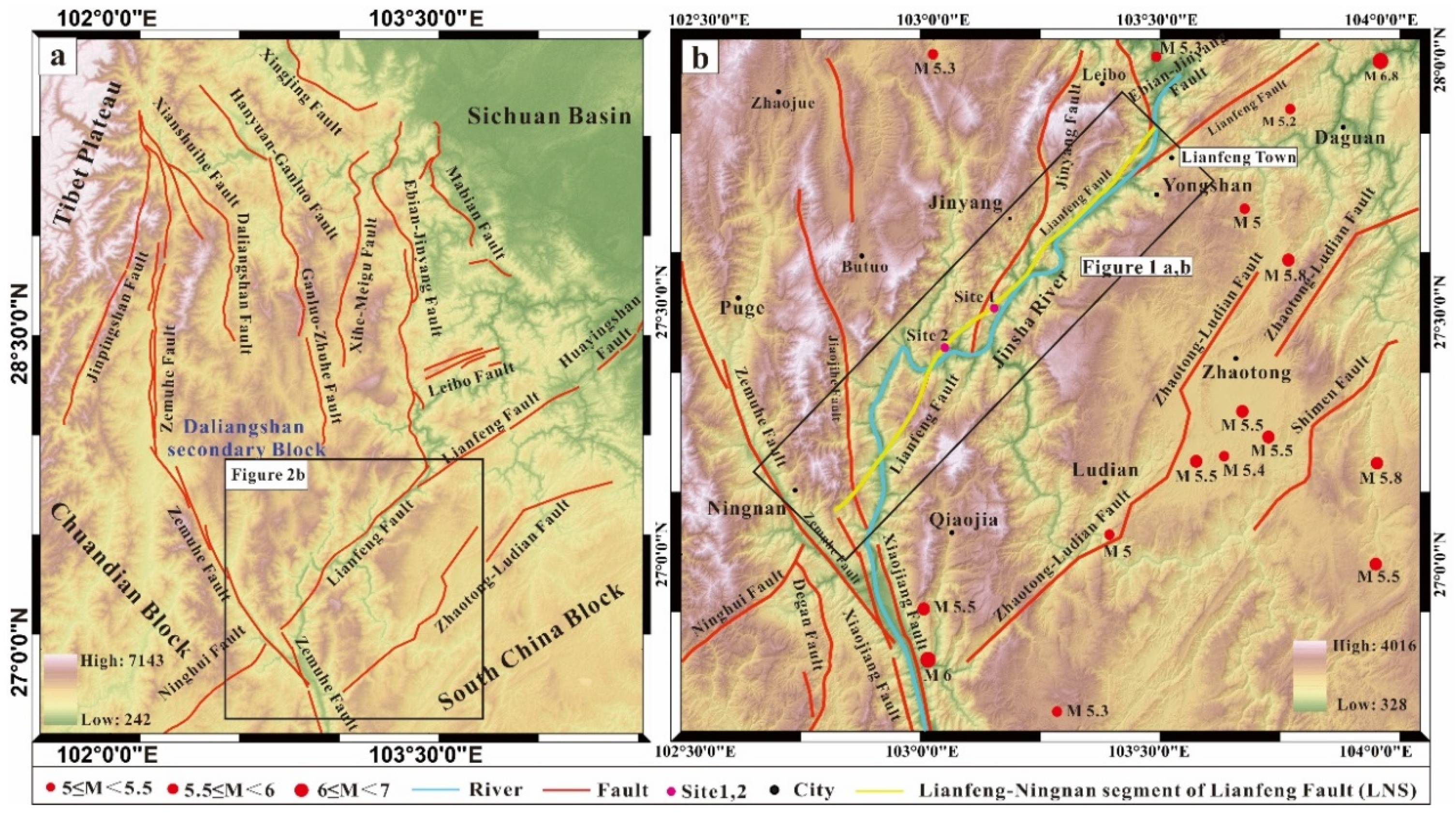
The Lianfeng fault is located on the eastern margin of the Tibetan Plateau and the southern boundary of the Daliangshan secondary block (Figure 2a) [1]. The fault developed along the Lianfeng anticline axis, starting from Yanjin in the north, passing through Lianfeng and Jinyang in the southwest, and ending near northern Ningnan, with a length of approximately 180 km. The overall strike is NE (northeast), and the strike of the fault section is NW (northwest), with dip angles of 40–80°. The Lianfeng fault has a complex structure, consisting of several faults that combine to form a 2~5 km-wide fault zone; the fault is a large regional fault and plays a controlling role in stratigraphic development and regional tectonic deformation. Geophysical data show that the fault zone is basal-cutting, and it has a close genetic relationship with folds and cuts all strata from the Aurignacian to Mesozoic along the Lianfeng anticline axis, with a total fault distance of several hundred metres [1,7]. Because of the change in the regional tectonic field since the Cenozoic, the ancient Huayingshan fault was severed by the Zemuhe–Xiaojiang fault and Mabian–Yanjin fault zone, forming a relatively independent fault zone (Figure 2a,b) [1,22]. The Lianfeng fault and Zhaotong–Ludian fault jointly play a role in absorbing and regulating the SE-directed movement of the Daliangshan secondary block [1,2].
Active faults, such as the Zemuhe fault, Xiaojiang fault, Zhaotong–Ludian fault and Ebian–Jinyang fault, are mainly distributed around the Lianfeng fault, and several earthquakes have occurred in recent years (Figure 2b), but no major earthquakes have occurred in the Lianfeng fault zone for at least 1700 years. This area is a seismic gap for major earthquakes [1]. Modern GPS velocity profile results show that the horizontal shortening rate of the NE-trending Lianfeng fault zone is approximately 5–6 mm/a, and the shear deformation rate is relatively small, approximately 1–2 mm/a, indicating that there is a significant accumulation of compressive strain in the Lianfeng fault zone [23]. Therefore, whether the Lianfeng fault zone has a medium- to long-term risk of strong earthquakes has become an urgent problem to be studied. In this paper, the stream geomorphic index of the Lianfeng–Ningnan segment (LNS) of the Lianfeng fault is calculated, and field investigation is added to further study the characteristics of the fault activity.

3. Methods

3.1. Stream Length Gradient (SL)

The extraction of stream longitudinal profiles is of great significance for studying the influence of tectonics on stream geomorphology [24,25,26,27,28]. Hack [29] proposed a formula for calculating the stream geomorphic index of the stream length gradient (SL) when studying the stream longitudinal section and divided the stream length gradient (SL) into three levels: 0 < SL < 200 indicates weak tectonic activity; 200 < SL < 400 indicates strong tectonic activity; and 400 < SL indicates intense tectonic activity in the region [30].
In a drainage basin, the slope of a stream is steeper in the upper reaches and slower near the estuary. Therefore, the SL is calculated by multiplying the slope of each stream segment by the distance from the middle point of the stream segment to the source of the stream to amplify the SL of the downstream stream segment [31]. To more accurately obtain the strength of regional tectonic activity, based on 12 m DEM data, this study extracted the elevation of the starting point and ending point of each stream by using the extraction analysis tool in the ArcGIS spatial analysis module [32,33]. Contour lines generated by the DEM were used to segment the river (Figure 3). In combination with the elevation difference in the regional relief, the contour line spacing was set at 300 m, and the average stream length gradient of each stream segment was taken as the final stream length gradient. This value can further reduce the impact caused by a large slope gap between the upstream and downstream parts of streams:
SL = (ΔH/ΔL) L
where ΔH/ΔL is the slope of the unit stream segment, and L is the distance from the source of the stream to the middle point of the stream segment (Figure 3).

3.2. Hypsometric Integral (HI)

Hypsometric integrals can be used to characterise the state of drainage basin erosion and geomorphic evolution and to quantitatively indicate the relationship between geomorphic evolution and tectonic uplift [31,34,35]. Davis [36] divided geomorphic evolution into the juvenile, prime and old stages. Strahler [13] analysed the hypsometric integral (HI) on the basis of the Davis [36] geomorphic erosion cycle theory and applied the hypsometric integral (HI) to discuss the characteristics of neotectonic activity and the stage of geomorphic evolution [37,38].
In the early stage of stream geomorphology development, the hypsometric integral is greater, i.e., HI > 0.6, and the surface is greatly affected by tectonic uplift. The stream geomorphology is in the old stage, the tectonic activity is weak, and the hypsometric integral is small, i.e., HI < 0.35. The stream geomorphology is in the prime stage, indicating moderate tectonic activity, and the hypsometric integral is 0.35 < HI < 0.6 [13,39]. Chang et al. [40] compared the three methods to calculate the hypsometric integral and found that the simplified formula derived by Pike et al. [41] was the most efficient. In this paper, a total of 73 streams in the LNS were extracted. The simplified formula derived by Pike et al. [41] was used to obtain the hypsometric integral (HI):
HI = (Hmean − Hmin)/(Hmax − Hmin)
In Formula (2), Hmax, Hmean and Hmin are the maximum, average and minimum values of drainage basin elevation, respectively.

4. Results

To obtain the intensity of tectonic activity in the LNS area, the SL values of 73 streams in the LNS area were calculated, and the HIs of 73 drainage basins were extracted. To fully obtain the differences in activity within the LNS, we divided the LNS into three segments: Lianfeng to Jinyang (north segment), Jinyang to Duping (middle segment) and Duping to Ningnan (south segment). The spatial distribution characteristics of fault activity are further discussed by analysing the stream geomorphic index of the three segments.

4.1. SL of LNS

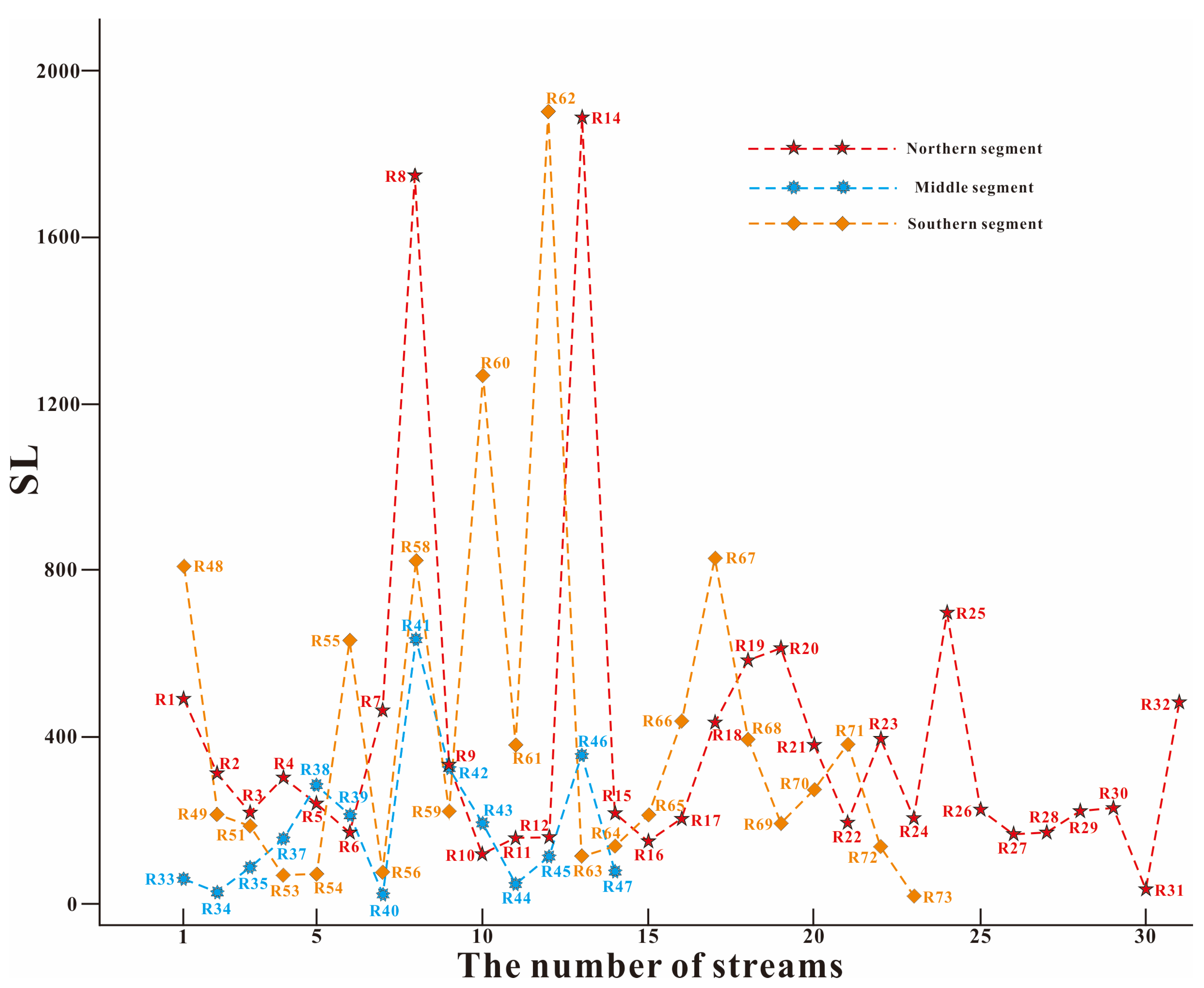
Figure 4 shows the distribution of SLs in the three segments of the LNS. In general, the average SL value in the three segments is less than 400, and the maximum SL value in the northern segment is 384 (Figure 4a), followed by 378 (Figure 4c) in the southern section. The intensity of tectonic activity is moderate. The mean SL value in the middle segment is the lowest and is less than 200 (Figure 4b), and the intensity of tectonic activity is weak. The spatial distribution characteristics of the tectonic activity intensity in the LNS area show that the tectonic activity in the southern and northern segments is relatively strong, while the tectonic activity in the middle segment is relatively weak.
Table 1 shows the statistical SL values of 73 streams in the LNS area, in which the SL values corresponding to R13, R36, R50, R52 and R57 are abnormally low. An analysis of the locations of streams with abnormally low values reveals that the streams with abnormally low values are mainly part of the main stream of the Jinsha River, so the elevation of the starting point of the river is also abnormally low. This phenomenon occasionally occurs in the three sections of the LNS region. Therefore, we believe that the abnormally low SL values do not affect the intensity of tectonic activity in the region analysed by using the SL value in this paper. Figure 5 shows the SL values in the three segments of the LNS. It can be seen from the dashed line chart that the SL values of the northern and southern segments are generally higher than that of the middle segment.

4.2. HI of the LNS

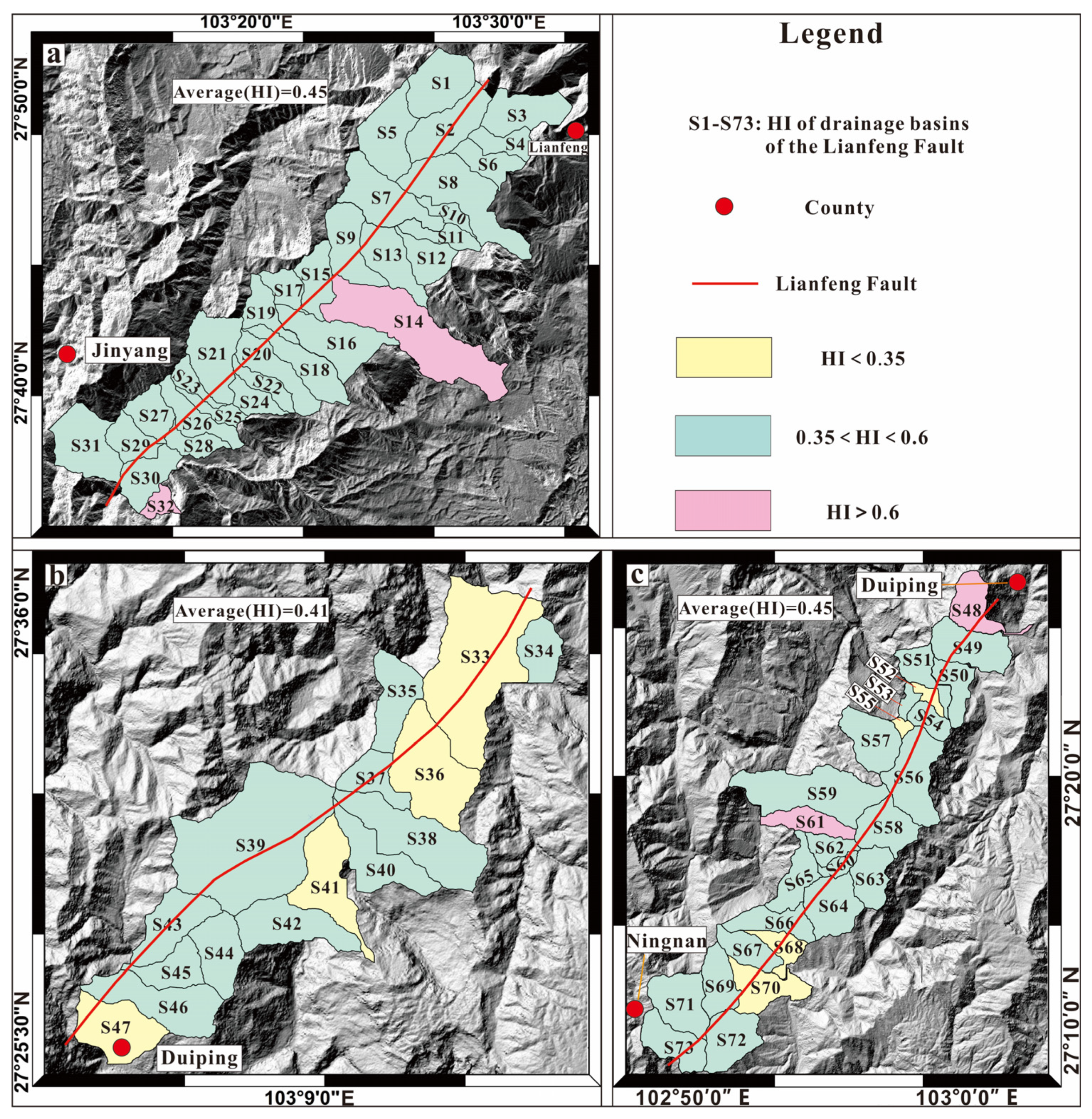
In Table 1, the HIs of 73 drainage basins (S1–S73) are also shown. The HI values of S1–S32 range from 0.36 to 0.66, and most of the values range from 0.36 to 0.6, indicating that the development of stream geomorphology in the northern segment is in the prime stage overall, and some areas may be in the transitional stage from the juvenile to the prime stage (Figure 6a). The HI values of S34–S47 range from 0.31–0.53. The stream geomorphology in some areas has developed into the old stage and is in transition from the prime to old stages overall, so the tectonic activity intensity in the middle segment is relatively weak (Figure 6b). The HI values of S48–S73 range from 0.28 to 0.66. Overall, the geomorphology is in the prime stage of stream geomorphological development and has the characteristics of juvenile and old stages.
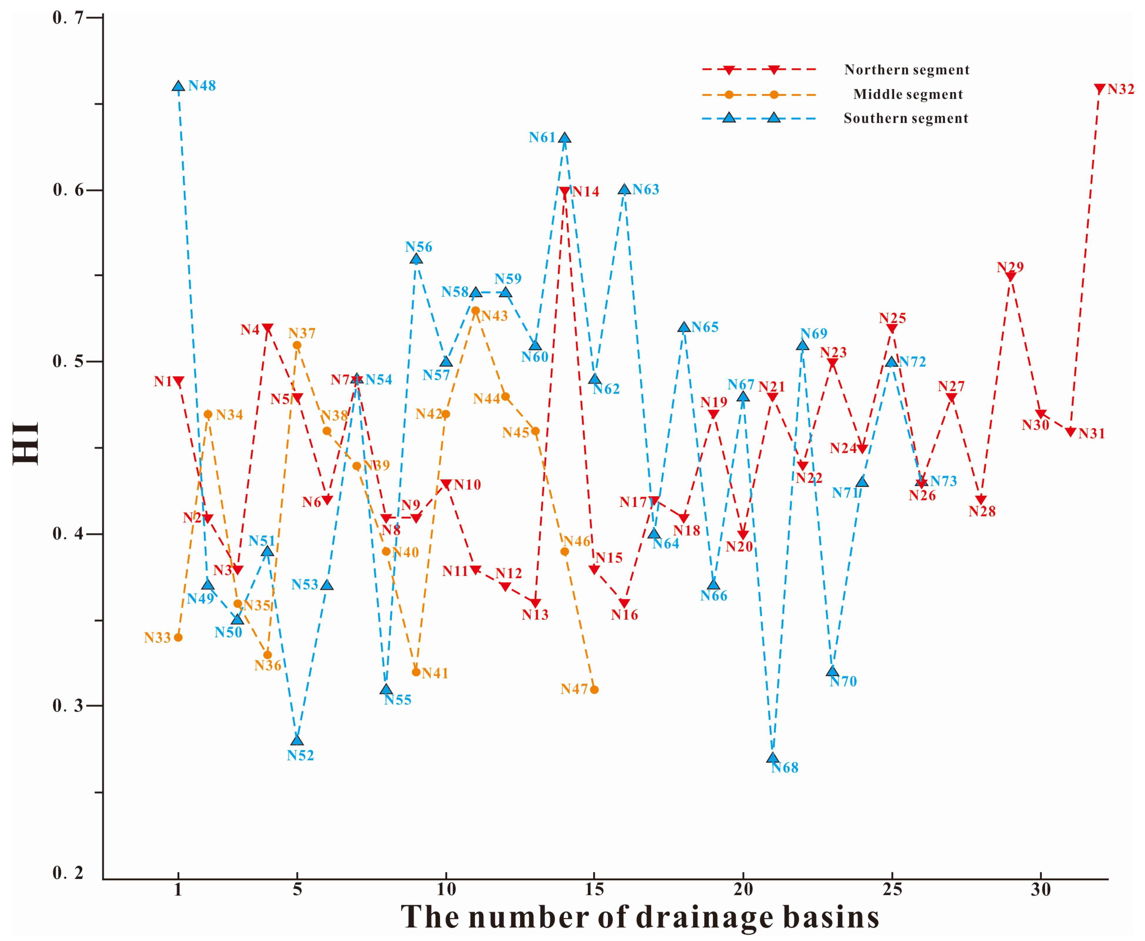
A comparison of the average HI values of the three segments reveals that the stream geomorphology is in the prime stage, indicating moderate tectonic activity in the LNS area. The average HI value in the northern and southern segments is 0.45, and the average HI value in the middle segment is 0.41. A comparison of the HI values of the three segments with the SL values reveals that the tectonic activity intensity in the LNS indicated by the stream geomorphic index is stronger in the southern and northern segments but weaker in the middle segment. The tectonic activity information, as indicated by the two types of stream geomorphic index, is verified by each other, which further indicates that the streams extracted in this study are highly sensitive to regional tectonic activity. It is reasonable to analyse the characteristics of the regional tectonic activity by extracting two aspects of the geomorphic index: SL and HI (Figure 5 and Figure 7).

5. Discussion

5.1. Limitations and Adaptability

The reclassification of flow accumulation during stream extraction will affect stream selection. The study area is located in a mountainous area with exposed bedrock and complex topography. There is a large river—the Jinsha River—in the area, and the surrounding water system is dense. To enable an extracted stream to fully respond to regional tectonic changes, this paper uses the Fill tool in the Hydrology toolset in ArcGIS 10.5 to first process the DEM, then analyses the flow direction of the DEM after filling and finally extracts the streams with catchment areas of more than 9 km2. According to regional topographic and geomorphic features, the streams selected by the above method are evenly distributed on both sides of the fault, and the corresponding stream geomorphic index can record fault activity information in detail. However, this selection method is more suitable for mountainous areas with exposed bedrock, a well-developed water system and large relief; the catchment area should be appropriately reduced for areas with relatively flat terrain and less dense water systems. In addition, we chose the 300 m interval contour line to segment the river based on the regional elevation difference and the drop between the upstream segment and the outlet of the river. This can be adjusted for different areas. If the contour interval is too small, the number of river segments will increase the workload. If the selected contour line interval is too large, the segmentation of the river will be insufficient, and the error cannot be reduced. According to the calculation method of SL in Figure 3, the segmentation of the stream with the 300 m contour line can divide most of the streams into at least three segments, reducing the error associated with the lower slope of the downstream segment. In the SL calculation, based on the traditional calculation method, this paper suggests that the use of appropriate contour lines for stream segmentation can reduce the calculation error, which provides a new idea for SL calculation in other areas. Furthermore, based on the calculation of regional SL and HI values, we realise that the southern and northern segments of the LNS are more active than the middle segment. This provides a new direction for future field investigation and a basis for regional seismic risk assessment.

5.2. Lithology and Climate

The stream geomorphic index in bedrock mountain areas is influenced by tectonics, lithology and climate [42,43,44]. To analyse the main factors controlling the stream geomorphic index, the above factors need to be discussed. Figure 8 shows that the Palaeozoic strata are most widely distributed in the region. They are mainly composed of marine sedimentary limestone and mudstone and are distributed in the eastern and southern parts of the area. The Mesozoic strata are mainly distributed in the northwestern part of the area, and a small amount is distributed in the eastern and southern regions. Some areas have fluvial lacustrine facies deposits. Quaternary strata are rarely exposed and are distributed sporadically in Butuo, Ludian and other places, mainly in the low terrace deposits and slope deposits of streams, and the distribution is very limited [1,4,5]. The boxed area in Figure 8 is the main area where the fault passes through, and the stream geomorphic index of this area is calculated. The area is dominated by Palaeozoic strata, and the lithology is dominated by hard limestone and mudstone. Zhu et al. [45] used the palynological analysis results from sedimentary layers and related literature records to reconstruct the climate conditions in the Liangshan region over the past ten thousand years. They concluded that the temperature in the Liangshan region has changed by 1–2 °C. Zheng et al. [46] analysed the characteristics of precipitation change in the Daliangshan area over the past 50 years and found that the interannual variation in precipitation was 3–5 mm/a and that most of the precipitation was concentrated in summer; thus, the climate change was not significant. These findings provide further evidence that climate is not the main driver of changes in the regional stream geomorphic index. A comparison of the strata in outcrops and distribution of the lithology in the southern, northern and middle segments of the LNS reveals that the difference between the strata in the outcrop and lithology is not significant, which indicates that the main factor of the variability of the LNS stream geomorphic index is not lithology.
The study area is generally in the subtropical monsoon climate zone, with obvious vertical zonal differences in climate and distinct dry and wet seasons. The rainy season is concentrated from May to October every year, when precipitation accounts for 85% of the annual precipitation. November to April of the next year is the dry season, when precipitation accounts for only approximately 15% of the annual precipitation [5]. The annual precipitation in most areas is greater than 1000 mL, and the seasonal variation in precipitation in the region is large, but the regional variation is not significant. In conclusion, the stream geomorphic index of the whole basin is less affected by lithology and climatic precipitation, which are not the main factors controlling the regional stream geomorphic index.

5.3. Tectonics

By extracting the stream geomorphic index, we found that the tectonic activity in the LNS area was strong. After excluding climatic and lithologic factors, tectonic activity is the most likely factor controlling the stream geomorphic characteristics in the region. However, the previous understandings of the activity era and activity of the Lianfeng fault are still unclear. Some scholars believe that the Lianfeng fault is in a state of lock-and-strain accumulation, and there is no clear geological evidence to prove fault activity [1,6]. As previously stated, fault activity cannot be the main factor controlling stream geomorphology in the LNS region. However, where the fault meets the Jinsha River, we found some clear signs of tectonic activity (Figure 9 and Figure 10). A record of fault activity is preserved in the sediments of gully offset and terrace deformation. Through the analysis and chronology of the active tectonic geomorphology and river terrace profile in the LNS area, we believe that the Lianfeng fault was an active fault in the Holocene, and the fault was still active until the middle Holocene. Wang et al. [8] concluded that the LNS area has been intensely active since the late Quaternary by analysing the Laojie profile, Shanjiangcun profile and Changpingzi profile, which is consistent with the results of our field investigation. The conclusion is also consistent with the regional tectonic activity shown by the stream geomorphic index mentioned above. From the perspective of a single fault, the stream geomorphology is obviously influenced by geological and active tectonics [47,48,49], and the active tectonics of faults in the LNS region are undoubtedly an important factor affecting regional stream geomorphic features.
Typical geomorphology and profiles are shown below. In Figure 2b, we mark the positions of Site 1 and Site 2.
Site 1: Gully offset and terrace profile on the north side of Wangjiawuji
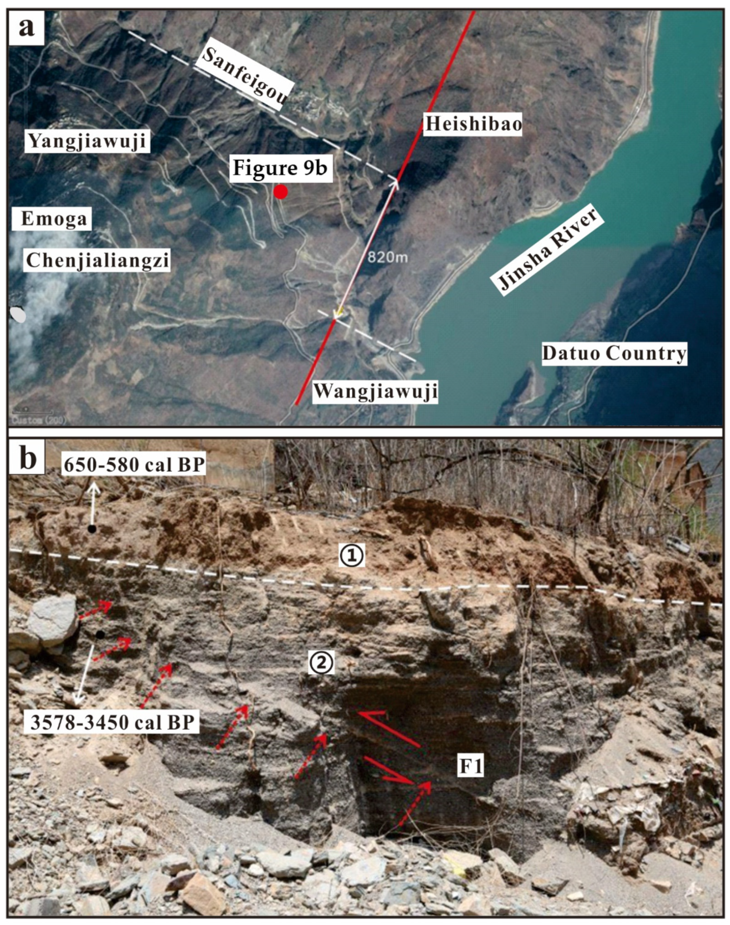
Wangjiawuji is located on the left bank terrace of the Jinsha River, and Sanfeigou is located 1 km north of Wangjiawuji. The right-lateral movement of the fault has caused the gully to break 820 m (Figure 9a). Moreover, a terraced profile was measured on the left bank of the Jinsha River near Wangjiawuji (Figure 9b). The strata in the profile from top to bottom are as follows: ① light red soil layer is unstratified, containing modern plant roots. Sample JSJ-14C-01 was taken for 14C analysis, and the dating results are 650–580 cal BP. ② The second layer is the sand gravel layer, which has horizontal bedding; the maximum grain size is approximately 5 cm, the rounding of gravel is good, and the sorting is good. The stratum is dislocated by the fault by approximately 5–10 cm. Sample JSJ-14C-02 was taken for 14C analysis, and the dating result was 3578–3450 cal BP. In Figure 9a,b, fault F1 shows right-lateral and thrust properties, and the latest activity occurred in approximately the middle Holocene.
Site 2: Duiping profile of the left bank of the Jinsha River
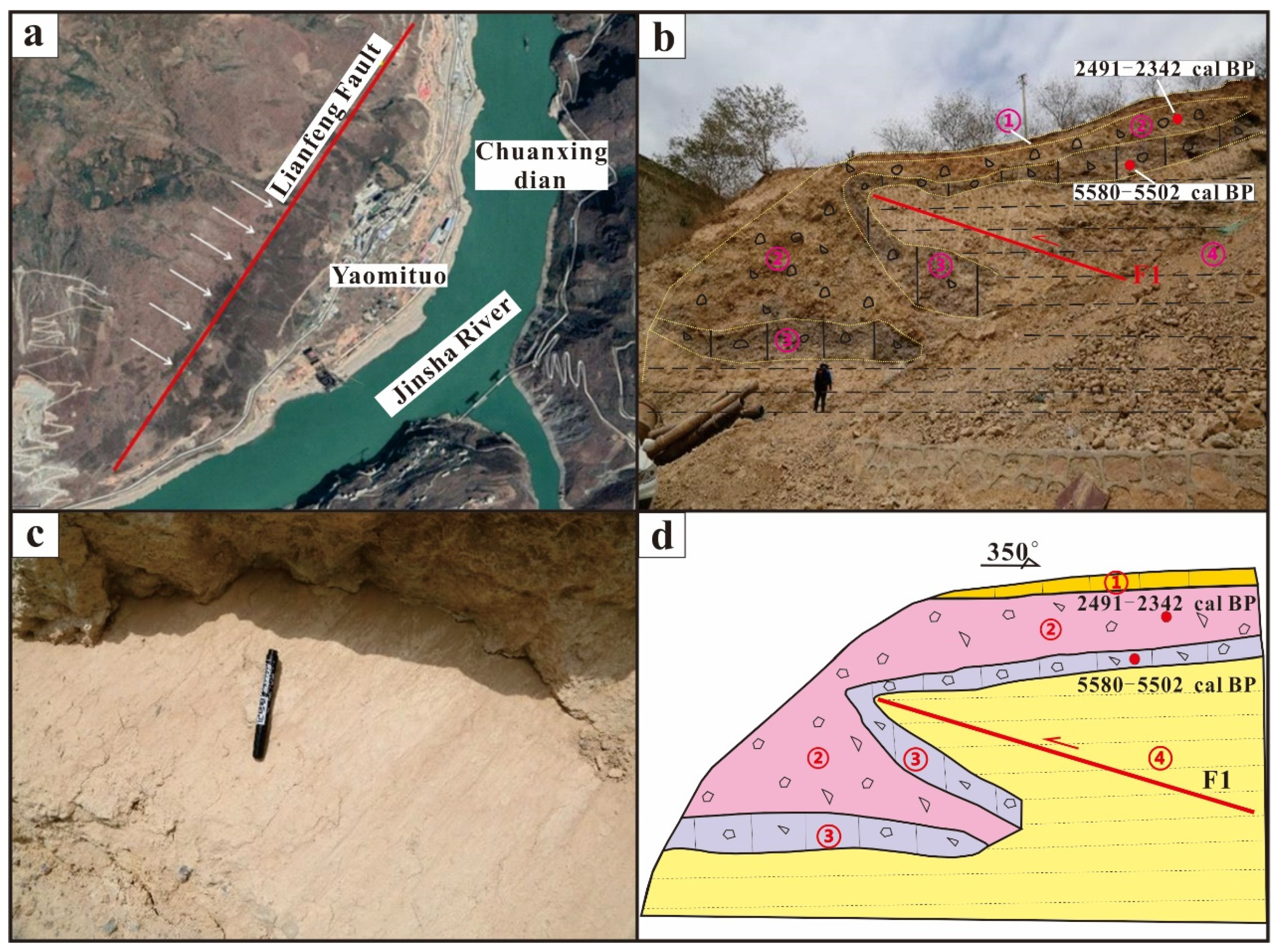
The fault profile is located on the left bank of the Jinsha River at the Chunjiang Bridge. In the remote sensing image, the vegetation boundary is linearly distributed in the NE direction under the influence of the fault (Figure 10a). The fault profile is exposed to fault striae. The strike of the profile where the sampling point and striae are located is 350° (Figure 10b–d). The strata in the profile from top to bottom are as follows: ① light grey gravelly clay overlain with a thinner layer of soil; ② gravel strata, in which the maximum grain sizes are 30–40 cm, the gravel is poorly rounded, and there is no sorting; taking sample JSJ-14C-04 for 14C analysis, the dating result is 2491–2342 cal BP; ③ the third stratum is black grey breccia, which has sorted gravel and lacks roundness; the dating result of 14C sample JSJ-14C-03 is 5580–5502 cal BP; and ④ the fourth stratum is a grey clay layer with no bedding.
Through remote sensing interpretation and field investigation, we identified two terrace profiles preserving fault activity signs. According to the two terrace profiles at Site 1 and Site 2, we found that fault activity caused the terrace strata to be faulted. We sampled and dated the upper and lower parts of the dislocated strata. The dating results suggest that the latest fault activity occurred in the mid-Holocene. This discovery changes the status of the Lianfeng fault from inactive to active in the Holocene. Due to the existence of earthquake gaps lasting thousands of years in the Lianfeng fault, more attention should be paid to the seismic risk assessment of the Lianfeng fault in the future.
In addition, from the perspective of large-scale regional tectonics, the continuous uplift and escape of the Tibetan Plateau since the Cenozoic has resulted in the continuous extrusion of plateau materials to the periphery and finally in the extrusion and escape of the Qiangtang block, Bayankhara block and Sichuan–Yunnan block to the E (east) and SE (southeast) [2,50,51,52,53,54], and a large strike-slip fault zone and thrust nappe structure were formed at the boundary of the block (Figure 11a).
The Xianshuihe–Anninghe fault zone and Zemuhe–Xiaojiang fault zone, which form the eastern boundary of the Sichuan–Yunnan block, are characterised by left-lateral strike-slip movement. The Red River fault zone on the western boundary is characterised by dextral strike-slip movement [55,56,57,58,59]. The Longmenshan fault zone is a large thrust fault zone that formed at the boundary of the South China block when the E-direction movement of the Bayankhara block was blocked. At the same time, influenced by the exchange of material and energy between the block movements, the Daliangshan secondary block was formed on the east side of the Sichuan–Yunnan block. Multiple active faults are also present in the interior and boundary of the Daliangshan secondary block, along which many historical earthquakes of magnitude 5 or above have occurred. The left-lateral strike-slip rate of the Anninghe–Zemuhe fault at its western boundary is 4–7 mm/a, and that of the Daliangshan fault at its inner boundary is 3–4 mm/a [60,61,62,63,64,65]. The LNS is located along the southeast boundary of the Daliangshan secondary block (Figure 11b). As the forwards position of the SE movement of the Daliangshan secondary block, the NE-trending Lianfeng fault is at an important tectonic deformation position and plays a role in absorbing and regulating the SE movement of the block [1,2]. The movement of the block is also one of the important factors leading to the strong tectonic activity in the LNS region.
Combined with the analysis of the active tectonic map of the Daliangshan region (Figure 11b), the northern and southern ends of the LNS are adjacent to the Zemuhe fault, southern Daliangshan fault, Ebian fault, and Mabian–Yanjin fault zones. The northern and southern segments of the LNS are located at the intersection of multiple faults and interact with nearby faults. This phenomenon often occurs in other fault zones as well. For example, the 2014 Ludian M6.5 earthquake in Yunnan Province occurred in the vicinity of the junction of the Baogunao fault and the Xiaohe fault, and this earthquake was a complex earthquake event associated with a conjugate rupture [66,67]. The 2008 Yutian M7.3 earthquake occurred at the intersection of the Altun Tagh fault, Kangxiwa fault and Maergechaka fault [68,69,70,71]. The example shows that the tectonic action in the fault intersection zone is very intense.
Although there has been a long period without earthquakes in the LNS [1], both the Zemuhe fault and the southern part of the Daliangshan fault adjacent to the southern segment of the LNS have high strike-slip rates, and several M7 palaeoseismic events have occurred [61,72,73,74]. Moreover, the Ebian fault and the Mabian–Yanjin fault zones adjacent to the northern segment of the LNS have both exhibited strong tectonic activity since the late Pleistocene [75,76]. Therefore, the interaction of faults at the intersection makes the tectonic activity of the southern and northern segments of the LNS relatively strong. This is consistent with the relatively strong tectonic activity in the northern and southern segments of the LNS, as reflected by the regional stream geomorphic index. Considering single fault activity, block movement patterns and regional fault interactions, we conclude that tectonics are the main factor leading to regional stream geomorphological features.

6. Conclusions

  • Based on DEM and ArcGIS hydrological analysis tools, 73 streams and their drainage basins in the LNS region were extracted. A calculation of the stream length gradient and hypsometric integral revealed that the regional stream geomorphic index was distributed differently spatially. The development of stream geomorphology in the LNS is generally in the prime stage. In the LNS area, the tectonic activity intensity indicated by the stream geomorphic index shows that the tectonic activity in the southern and northern segments is stronger, while the tectonic activity in the middle segment is relatively weak.
  • There is no significant difference in the spatial distribution of lithology and climate in the LNS region, meaning lithology and climate are not the main factors controlling the regional stream geomorphic index.
  • The analysis of the terrace profile and typical geomorphology in the LNS area reveals that the LNS was an active fault in the Holocene. Based on the analysis of regional single fault activity, block movement and regional fault interaction, we conclude that tectonics are the main factor contributing to the differential spatial distribution of the stream geomorphic index.

Author Contributions

Conceptualization, Z.H.; Data curation, L.L.; Formal analysis, D.X. and L.G.; Funding acquisition, Z.H.; Investigation, D.X. and L.W.; Methodology, Z.H. and D.X.; Project administration, Z.H.; Resources, Z.H.; Software, D.X.; Supervision, Z.H.; Validation, D.X.; Visualization, L.L.; Writing—original draft, D.X.; Writing—review & editing, Z.H. All authors have read and agreed to the published version of the manuscript.

Funding

This research was funded by the National Science and Technology Basic Resources Investigation Program of China, grant number 2021FY100104; the National Natural Science Foundation of China, grant number 41872227; and a Research Grant from the National Institute of Natural Hazards, Ministry of Emergency Management of China, grant number ZDJ2019-21.

Data Availability Statement

The topography data are from the website https://tandemx-science.dlr.de (accessed on 20 June 2022). The earthquake catalogue data are from the website https://data.earthquake.cn (accessed on 20 October 2022). The regional lithologic data are from the website https://www.ngac.org.cn (accessed on 12 November 2022).

Acknowledgments

We thank the reviewers and editors for their help in improving the manuscript.

Conflicts of Interest

The authors declare no conflict of interest.

References

  1. Wen, X.Z.; Du, F.; Yi, G.X.; Long, F.; Fan, J.; Yang, P.X.; Xiong, R.W.; Liu, X.X.; Liu, Q. Earthquake risk background of Zhaotong and Lianfeng fault zones in eastern Sichuan-Yunnan boundary. Chin. J. Geophys. 2013, 56, 3361–3372. [Google Scholar]
  2. Chang, Z.; Zhou, R.; An, X.; Chen, Y.; Zhou, Q.; Li, J. Late quaternary activity of Zhaotong-Ludian fault and its tectonic significance. Seismol. Geol. 2014, 36, 1260–1279. [Google Scholar]
  3. Xie, Z.; Zheng, Y.; Liu, C.; Xiong, X.; Li, Y.; Zheng, X. Source parameters of the 2014 MS6.5 ludian earthquake sequence and their implications on the seismogenic structure. Seismol. Res. Lett. 2015, 86, 1614–1621. [Google Scholar] [CrossRef]
  4. Zhang, W. Study on Late Quaternary Activity Characteristics of Lianfeng and Zhaotong Fault Zones; Institute of Earthquake Prediction, China Earthquake Administration: Beijing, China, 2018. [Google Scholar]
  5. Wang, Y. Geomorphic and Sedimentary Records of Tectonic Activity Since Late Cenozoic in the Lianfeng Fault Belt and Its Adjacent Areas; Institute of Crustal Stress, China Earthquake Administration: Beijing, China, 2019. [Google Scholar]
  6. Xu, X.; Jiang, G.; Yu, G.; Wu, X.; Zhang, J.; Li, X. Determination of seismogenic fault and discussion on its tectonic attributes for the Ludian M6.5 earthquake. Chin. J. Geophys. 2014, 57, 3060–3068. [Google Scholar]
  7. Zhang, W.; Li, W.; Tian, Q.; Xu, Y.; Wang, L. Discussion on Quaternary activity characteristics of Lianfeng and Zhaotong fault zone based on deformation of broad vally surface of Niulan River. Earthquake 2018, 38, 22–36. [Google Scholar]
  8. Wang, Y.; Li, D. Geomorphological and sedimentary records of Late Quaternary activities of Qiaojia-Jinyang segment of Lianfeng fault zone, Southwest China. Environ. Earth Sci. 2022, 81, 155. [Google Scholar] [CrossRef]
  9. Bi, L. Study on Parameters of Active Tectonic Geomorphology Based on DEM; China Earthquake Administration: Beijing, China, 2011. [Google Scholar]
  10. He, X.; Zhang, X.; He, Z. Research progress and thinking of neotectonic movement based on tectonic geomorphic parameters. Geoscience 2014, 28, 119–130. [Google Scholar]
  11. Dong, S.; Zhang, P.; Zhang, H.; Zheng, W.; Chen, H. Drainage responses to the activity of the langshan range-front fault and tectonic implications. J. Earth Sci. 2018, 29, 193–209. [Google Scholar] [CrossRef]
  12. He, C.; Rao, G.; Yang, R.; Hu, J.; Yao, Q.; Yang, C.J. Divide migration in response to asymmetric uplift: Insights from the Wula Shan horst, North China. Geomorphology 2019, 339, 44–57. [Google Scholar] [CrossRef]
  13. Strahler, A.N. Hypsometric (area-altitude) analysis of erosional topography. GSA Bull. 1952, 63, 1117–1142. [Google Scholar] [CrossRef]
  14. Walcott, R.C.; Summerfield, M.A. Scale dependence of hypsometric intergrals: An analysis of southeast African basins. Geomorphology 2008, 96, 174–186. [Google Scholar] [CrossRef]
  15. Zhao, H.; Li, Y.; Yang, J. The slope index of river length and the neotectonic significance of Hack profile in the North Tianshan Basin. Acta Sci. Univ. Pekin. 2010, 46, 237–244. [Google Scholar]
  16. Zhang, J.; Li, C.; Zhang, M. Golmud river basin area—Elevation integral values of geomorphology analysis. J. Mt. 2011, 29, 257–268. [Google Scholar]
  17. Guo, L.; He, Z.; Li, L. Response of stream Geomorphic Indices to Piedmont Fault Activity in the Northern Segment of the Red River Fault Zone. Remote Sens. 2023, 15, 988. [Google Scholar] [CrossRef]
  18. Bashir, B.; Alsalman, A.; Bachir, H.; Elnobi, M. GIS-Analysis for Active Tectonics Assessment of Wadi Al-Arish, Egypt. Appl. Sci. 2023, 13, 2659. [Google Scholar] [CrossRef]
  19. Derakhshani, R.; Zaresefat, M.; Nikpeyman, V.; GhasemiNejad, A.; Shafifieibafti, S.; Rashidi, A.; Nemati, M.; Raoof, A. Machine Learning-Based Assessment of Watershed Morphometry in Makran. Land 2023, 12, 776. [Google Scholar] [CrossRef]
  20. Barman, B.K.; Rao, C.U.; Rao, K.S.; Patel, A.; Kushwaha, K.; Singh, S.K. Geomorphic Analysis, Morphometric-based Prioritization and Tectonic Implications in Chite Lui River, Northeast India. J. Geol. Soc. India 2021, 97, 385–395. [Google Scholar] [CrossRef]
  21. Anand, A.; Pradhan, S. Assessment of active tectonics from geomorphic indices and morphometric parameters in part of Ganga basin. J. Mt. Sci. 2019, 16, 1943–1961. [Google Scholar] [CrossRef]
  22. Zhou, R.; Tang, R.; Qian, H.; Wen, D.; Ma, S.; He, Y.; Pu, X. Application of earthquake structure analogy method: A case study of Huaying Mountain fault zone in eastern Sichuan. Seismol. Res. 1997, 3, 68–74. [Google Scholar]
  23. Liu, X. Study on the Major Faults in the Middle Part of the Eastern Boundary of Sichuan-Yunnan Block and the Interseismic Deformation of the Southern Section of Longmenshan Fault Belt; Institute of Geology, China Earthquake Administration: Beijing, China, 2017. [Google Scholar]
  24. Font, M.; Amorese, D.; Lagarde, J.-L. DEM and GIS analysis of the stream gradient index to evaluate effects of tectonics: The Normandy intraplate area (NW France). Geomorphology 2010, 119, 172–180. [Google Scholar] [CrossRef]
  25. Glade, R.C.; Shobe, C.M.; Anderson, R.S.; Tucker, G.E. Canyon shape and erosion dynamics governed by channel-hillslope feedbacks. Geology 2019, 47, 650–654. [Google Scholar] [CrossRef]
  26. Hayakawa, Y.S.; Oguchi, T. GIS analysis of fluvial knickzone distribution in Japanese mountain watersheds. Geomorphology 2009, 111, 27–37. [Google Scholar] [CrossRef]
  27. Goldrick, G.; Bishop, P. Regional analysis of bedrock stream long profiles: Evaluation of Hack’s SL form, and formulation and assessment of an alternative (the DS form). Earth Surf. Process. Landf. 2007, 32, 649–671. [Google Scholar] [CrossRef]
  28. Clark, M.K.; Schoenbohm, L.M.; Royden, L.H.; Whipple, K.X.; Burchfiel, B.C.; Zhang, X.; Tang, W.; Wang, E.; Chen, L. Surface uplift, tectonics, and erosion of eastern Tibet from large-scale drainage patterns. Tectonics 2004, 23, TC1006. [Google Scholar] [CrossRef]
  29. Hack, J.T. Stream-profile analysis and stream-gradient index. J. Res. U.S. Geol. Surv. 1973, 1, 421–429. [Google Scholar]
  30. Ji, Y.; Gao, H.; Pan, B.; Li, Z.; Guan, D.; Du, G. New tectonic significance of SL parameter and Hack profile in the upper reaches of Weihe River Basin. J. Lanzhou Univ. 2011, 47, 16. [Google Scholar]
  31. Xu, W.; Yuan, Z.; Liu, Z.; Gao, Z. Zhongtiao mountains north river geomorphic parameter and the new tectonic significance. J. Arid Areas 2018, 9, 10091017. [Google Scholar]
  32. Gao, M.; Zeilinger, G.; Xu, X.; Wang, Q.; Hao, M. DEM and GIS analysis of geomorphic indices for evaluating recent uplift of the northeastern margin of the Tibetan Plateau, China. Geomorphology 2013, 190, 61–72. [Google Scholar] [CrossRef]
  33. Kirby, E.; Whipple, K.X.; Tang, W.; Chen, Z. Distribution of active rock uplift along the eastern margin of the Tibetan Plateau: Inferences from bedrock channel longitudinal profiles. J. Geophys. Res. Solid Earth 2003, 108, 2217. [Google Scholar] [CrossRef]
  34. Ma, T.X.; Yang, W.G.; Zhu, L.D.; Zhang, H.L.; Zhong, Z.; Xie, L.; Mai, Y.J.; Luo, L.; Cao, Z.C. Geomorphic parameter characteristics and tectonic geomorphic significance in the middle reaches of Yarlung Zangbo River. J. Chengdu Univ. Technol. 2022, 49, 502–512. [Google Scholar]
  35. Singh, O.; Sarangi, A.; Sharma, M.C. Hypsometric integral estimation methods and its relevance on erosion status of north-western lesser himalayan watersheds. Water Resour. Manag. 2008, 22, 1545–1560. [Google Scholar] [CrossRef]
  36. Davis, W.M. The geographical cycle. Geogr. J. 1899, 14, 481–504. [Google Scholar] [CrossRef]
  37. Wang, J. Response of Fluvial Geomorphic Index and Lacustrine Deposition to Piedmont Fault Activity in Daqingshan Basin; Emergency Management Department of National Natural Disaster Prevention Research Institute: Beijing, China, 2021. [Google Scholar]
  38. Guan, X.; Pang, L.; Jiang, Y. Spatial characteristics and tectonic geomorphic significance of geomorphic metrology indexes in Taihang Mountains. Chin. J. Geomech. 2021, 27, 280–293. [Google Scholar]
  39. Xin, Z.; Xu, J.; Ma, Y. Hypsometric integral analysis and its sediment yield implications in the loess Plateau, China. J. Mt. Sci. 2008, 3, 335–363. [Google Scholar]
  40. Chang, Z.Y.; Wang, J.; Bai, S.-B.; Zhang, Z.G. Area of elevation comparing the calculation methods of integral value. J. Resour. Environ. Arid Areas 2015, 29, 171–175. [Google Scholar] [CrossRef]
  41. Pike, R.; Wilson, S. Elevation-relief ratio, hypsometric integral, and geomorphic area-altitude analysis. Geol. Soc. Am. Bull. 1971, 82, 1079–1084. [Google Scholar] [CrossRef]
  42. Wang, J.Y.; He, Z.T. Responses of stream geomorphic indices to piedmont fault activity in the Daqingshan area of China. J. Earth Sci. 2020, 31, 978–987. [Google Scholar] [CrossRef]
  43. Liang, O.; Ren, J.; Lv, Y. Response of fluvial geomorphic features to the activity of Huya fault zone in the Fujiang River Basin. Seismol. Geol. 2018, 40, 42–56. [Google Scholar]
  44. Liang, O.B. Fluvial Geomorphic Index and Its Tectonic Signifificance at the Eastern Foot of Helan Mountain; Institute of Crustal Stress, China Earthquake Administration: Beijing, China, 2019. [Google Scholar]
  45. Zhu, S. Climate changes in Liangshan Mountain areas since 10000 years before. Yunnan Geogr. Environ. Res. 2007, 2, 1–4. [Google Scholar]
  46. Zheng, Z.; Liang, X.; Wang, J.; Mo, F.; Liu, K.; Li, J.; Fan, Y. Analyses of variation characteristics of the precipitation in the North of Liangshan City in recent 50 years. Chin. Agric. Sci. Bull. 2014, 30, 250–255. [Google Scholar]
  47. Zhang, H.; Yang, N.; Liu, S.F.; Zhang, Y.Q. New progress in the application of digital elevation model (DEM) in the study of tectonic geomorphology. Geol. Bull. 2006, 6, 660–669. [Google Scholar]
  48. Liu, J.; Zhang, J.Y.; Ge, Y.K.; Wang, W.; Zeng, L.; Li, G.; Lin, X. Tectonic geomorphology: A cross study on the interaction of tectono-climate-surface processes. Chin. Sci. Bull. 2018, 63, 3070–3088. [Google Scholar]
  49. Cao, P.J.; Cheng, S.Y.; Lin, H.X.; Wang, X.; Li, M.; Chen, J. Application and prospect of DEM in quantitative analysis of tectonic geomorphology. J. Geomech. 2021, 27, 949–962. [Google Scholar]
  50. Tapponnier, P.; Peltzer, G.; Le Dain, A.Y.; Armijo, R.; Cobbold, P. Propagating extrusion tectonics in Asia: New insights from simple experiments with plasticine. Geology 1982, 10, 611–616. [Google Scholar] [CrossRef]
  51. Tapponnier, P.; Peltzer, G.; Armijo, R. On the mechanics of the collision between India and Asia. Geol. Soc. Lond. Spec. Publ. 1986, 19, 113–157. [Google Scholar] [CrossRef]
  52. Tapponnier, P.; Zhiqin, X.; Roger, F.; Meyer, B.; Arnaud, N.; Wittlinger, G.; Yang, J. Oblique stepwise rise and growth of the Tibet plateau. Science 2001, 294, 1671–1677. [Google Scholar] [CrossRef]
  53. Zhang, P.Z.; Wang, M.; Gan, W.J. Slip rates along major active faults from GPS measurements and constraints on contemporary continental tectonics. Earth Sci. Front. 2003, 10, 81–92. [Google Scholar]
  54. Xu, X.W.; Wen, X.Z.; Zheng, R.Z.; Ma, W.; Song, F.; Yu, G. Pattern of latest tectonic motion and dynamics of faulted blocks in Yunnan and Sichuan. Sci. China 2003, 33, 151–162. [Google Scholar]
  55. Chen, G. Fresh Water River Fault Zone Structure, Landform and Seismicity Research; China University of Geosciences: Wuhan, China, 2022. [Google Scholar]
  56. Liang, J.M. Characteristics of the Late-Quaternary fault activity of the Xianshuihe Fault; Institute of Earthquake Prediction, China Earthquake Administration: Beijing, China, 2019. [Google Scholar]
  57. Yu, J. Study on Fault Activity Rate in Typical Section of Zemuhe Fault Zone; Institute of Earthquake Prediction, China Earthquake Administration: Beijing, China, 2010. [Google Scholar]
  58. Ren, Z. Study on Palaeoearthquake in Zemuhe Fault Zone; Institute of Earthquake Prediction, China Earthquake Administration: Beijing, China, 2007. [Google Scholar]
  59. Song, J. Study on the Differentiation of Segmental-Locking in the Anning He-Zemuhe-Xiaojiang Fault Zone and Stress Evolution Characteristics in Sichuan-Yunnan Region; Institute of Seismology, China Earthquake Administration: Beijing, China, 2016. [Google Scholar]
  60. Tang, R.C.; Han, W.B. Active Faults and Earthquakes in Sichuan; Seismological Press: Beijing, China, 1993. [Google Scholar]
  61. He, H.L.; Ikeda, Y. Faulting on the Anninghe fault zone, Southwest China in Late Quaternary and its movement model. Acta Seismol. Sin. 2007, 20, 571–583. [Google Scholar] [CrossRef]
  62. Ran, Y.K.; Chen, L.C.; Cheng, J.W.; Gong, H.L. Late quaternary surface deformation and rupture behavior of strong earthquake on the segment north of Mianning of the Anninghe fault. Sci. China D Earth Sci. 2008, 51, 1224–1237. [Google Scholar] [CrossRef]
  63. Zhou, R.J. Average slip rate of Daliang Mountains Fault zone in Sichuan in late Quaternary period. J. Seismol. Res. 2003, 26, 191–196. [Google Scholar]
  64. Chen, C.Y.; He, H.L. Crust shortening of Daliangshan tectonic zone in Cenozoic era and its implication. Seismol. Geol. 2008, 30, 443–453. [Google Scholar]
  65. Wei, Z.Y.; He, H.L.; Shi, F.; Xu, Y.R.; Bi, L.S.; Sun, H.Y. Slip rate on the south segment of Daliangshan Fault zone. Seismol. Geol. 2012, 34, 282–293. [Google Scholar]
  66. Wang, W.L.; Wu, J.P.; Fang, L.H.; Lai, G.J. 2014 Ludian MS6.5 earthquake sequence Double difference positioning. Chin. J. Geophys. 2014, 57, 3042–3051. [Google Scholar]
  67. Zhang, Y.; Chen, Y.T.; Xu, L.S.; Wei, X.; Jin, M.; Zhang, S. 2014 MW6.1 earthquake in Ludian, Yunnan Province: A Conjugate rupture earthquake. Chin. J. Geophys. 2015, 58, 153–162. [Google Scholar]
  68. Wan, Y.G.; Shen, Z.K.; Sheng, S.Z.; Xu, X. The impact of the 2008 Yutian M7.3 earthquake on Zhou Influence of circumferential faults and regional structural interpretation of normal fault mechanism. Chin. J. Geophys. 2010, 53, 280–289. [Google Scholar]
  69. Xu, X.W.; Tan, X.B.; Wu, G.D.; Chen, J.; Shen, J.; Fang, W.; Song, H. Surface rupture in the 2008 Yutian MS7.3 earthquake Discussion on strip characteristics and their construction Attributes. Seismol. Geol. 2011, 33, 462–471. [Google Scholar]
  70. Cheng, H.; Pang, Y.; Dong, Y.; Zhang, H.; Shi, Y. Yu Tian twice in 2008 and 2014 MS7.3 Stress environment of earthquake breeding. Chin. J. Geophys. 2014, 57, 3238–3246. [Google Scholar]
  71. Wu, W. Stress distribution characteristics of fault intersection in Anninghe-Zemuhe fault zone and its surrounding areas. Seismol. Res. 2020, 43, 601–609+767. [Google Scholar]
  72. Du, P. Evolution history and deformation mechanism of the Zemuhe fault zone. Sichuan Earthq. 2000, 65–79. [Google Scholar] [CrossRef]
  73. Song, F.; Li, R.; Xu, X. Preliminary results of paleo-earthquake research on the Daliangshan fault zone in Sichuan Province. Seismol. Geol. 2002, 24, 27–34. [Google Scholar]
  74. He, H.; Yasuta, I.; He, Y.; Masami, T.; Chen, J.; Chen, C.; Tian, L.; Tomoo, E.; Shinsuke, O. Bending and straightening of the middle part of Xianshuihe-Xiaojiang fault system in the new Daliangshan Fault belt. Sci. China Earth Sci. 2008, 38, 564–574. [Google Scholar]
  75. Zhang, Q.; Peng, X.; Zhu, J. Tectonic characteristics and activity of Majian-Lebo-Emian-Jinyang fault. J. Sichuan Geol. 2019, 39, 30–33. [Google Scholar]
  76. Zhang, S.; Nie, G.; Liu, X.; Ren, J.; Su, G. Fault movement association and seismic subdivision Characteristics of Yingjing-Mabian-Yanjin Thrusting tectonic Belt. Seismol. Geol. 2005, 27, 221–233. [Google Scholar]
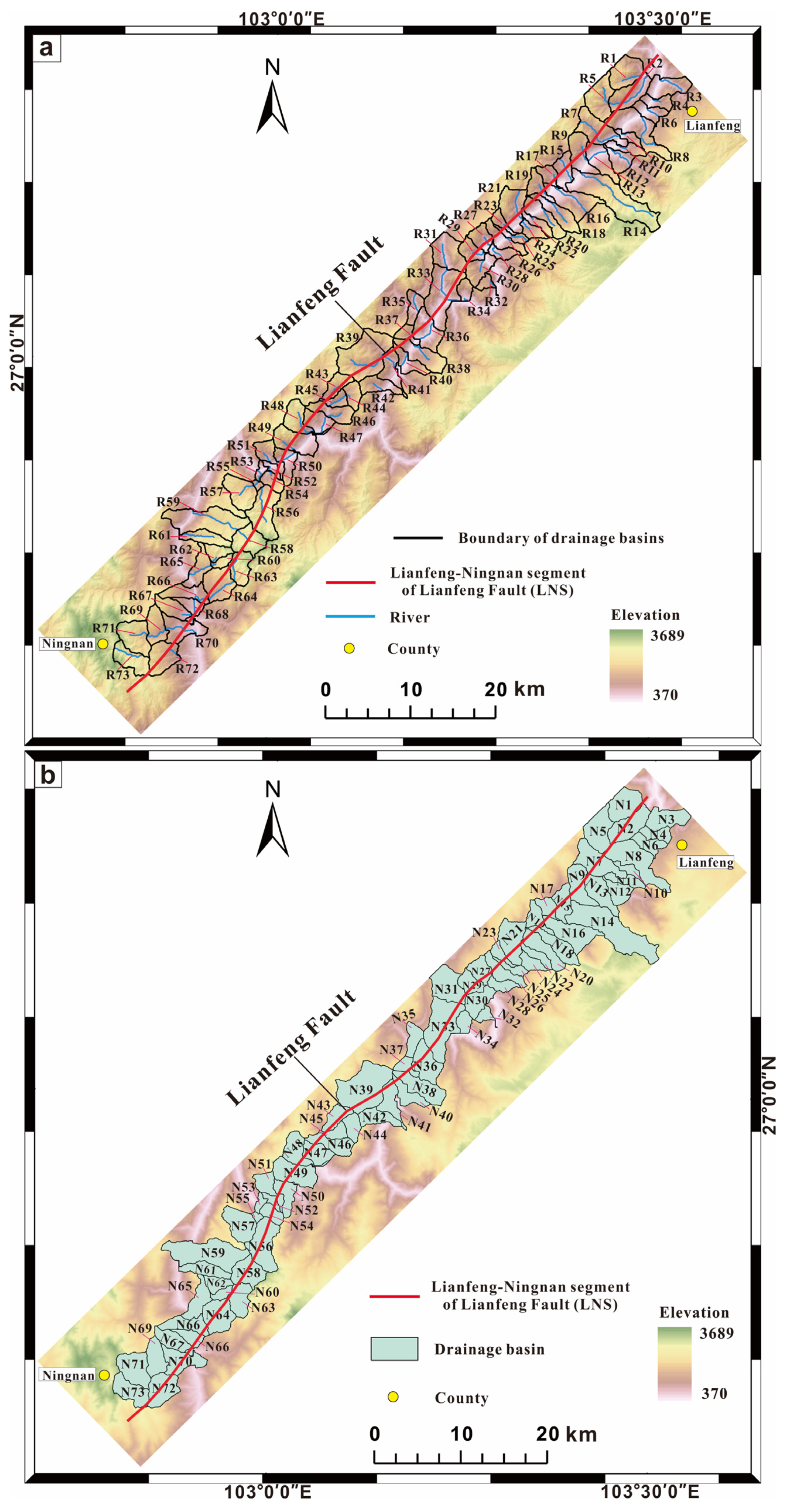
Figure 1. Distribution of streams and drainage basins in the LNS: (a) stream distribution map of the LNS; (b) drainage basin map of the LNS.
Remotesensing 15 02309 g001
Figure 2. Regional seismotectonic map: (a) geographic location of the study area; the study area is located on the eastern margin of the Tibetan Plateau and the eastern margin of the Sichuan–Yunnan block, which is the boundary between the Daliangshan secondary block and the South China block; (b) seismic distribution map of earthquakes of magnitude 5 or above around the study area.
Remotesensing 15 02309 g002
Figure 3. Diagram for calculating the SL. In the figure, the elevations of H1 and H2 can be read directly from the contour line, and ΔH is the difference in the elevation of the stream segment. The river source elevation can be extracted in ArcGIS. In the figure, the river is divided into 5 segments according to the 300 m contour line. The calculation of the SL in each segment refers to SL2. Finally, the average value of SL1–SL5 is taken as the stream length gradient of R1 (SL(R1)).
Remotesensing 15 02309 g003
Figure 4. SL of the LNS: (a) SL distribution map in the northern segment of the LNS; (b) SL distribution map in the middle segment of the LNS; (c) SL distribution map in the southern segment of the LNS.
Remotesensing 15 02309 g004
Figure 5. Comparison of SL values in the three segments of the LNS. The red dashed line represents the SLs of the northern segment. The blue dashed line represents the SLs of the middle segment. The yellow dashed line represents the SLs of the southern segment.
Remotesensing 15 02309 g005
Figure 6. HI of the LNS. (a) Map of the HI distribution in the northern segment of the LNS; (b) map of the HI distribution in the middle segment of the LNS; (c) map of the HI distribution in the southern segment of the LNS.
Remotesensing 15 02309 g006
Figure 7. Comparison of HI values in the three segments of the LNS. The red dashed line represents the HIs of the northern segment. The yellow dashed line represents the HIs of the middle segment. The blue dashed line represents HIs of the southern segment.
Remotesensing 15 02309 g007
Figure 8. Regional geological map (modified from the 1:200,000 geological map), black square represents study area.
Remotesensing 15 02309 g008
Figure 9. Gully offset and terrace profile in Wangjiawuji. (a) Sanfeigou offset of 820 m; (b) fault offset in the terrace profile.
Remotesensing 15 02309 g009
Figure 10. Profile of the left bank of the Jinsha River in Duiping town. (a) Fault remote sensing images; (b) fault profile; (c) fault striae of the profile; (d) schematic diagram of the fault profile.
Remotesensing 15 02309 g010
Figure 11. Regional dynamics model. (a) Block movement model of the eastern margin of the Tibetan Plateau; (b) active tectonic map of the Daliangshan secondary block.
Remotesensing 15 02309 g011
Table 1. The SLs of streams and the HIs of drainage basins.
SegmentStreamSLAverage SLDrainage BasinHIAverage HI
Northern segmentR1494384N10.490.45
R2315N20.41
R3219N30.38
R4306N40.52
R5242N50.48
R6174N60.42
R7467N70.49
R81750N80.41
R9336N90.41
R10121N100.43
R11161N110.38
R12162N120.37
R131N130.36
R141889N140.60
R15220N150.38
R16153N160.36
R17208N170.42
R18440N180.41
R19587N190.47
R20618N200.40
R21384N210.48
R22198N220.44
R23398N230.50
R24210N240.45
R25700N250.52
R26226N260.43
R27169N270.48
R28175N280.42
R29225N290.55
R30233N300.47
R3139N310.46
R32487N320.66
Middle segmentR3363175N330.340.41
R3430N340.47
R3591N350.36
R363N360.33
R37158N370.51
R38286N380.46
R39215N390.44
R4024N400.39
R41637N410.32
R42327N420.47
R43196N430.53
R4449N440.48
R45115N450.46
R46358N460.39
R4780N470.31
Southern segmentR48811378N480.660.45
R49217N490.37
R509N500.35
R51188N510.39
R521N520.28
R5371N530.37
R5473N540.49
R55633N550.31
R5678N560.56
R571N570.50
R58825N580.54
R59224N590.54
R601269N600.51
R61385N610.63
R621900N620.49
R63118N630.60
R64141N640.40
R65217N650.52
R66442N660.37
R67831N670.48
R68396N680.27
R69196N690.51
R70276N700.32
R71385N710.43
R72139N720.50
R7320N730.43
Disclaimer/Publisher’s Note: The statements, opinions and data contained in all publications are solely those of the individual author(s) and contributor(s) and not of MDPI and/or the editor(s). MDPI and/or the editor(s) disclaim responsibility for any injury to people or property resulting from any ideas, methods, instructions or products referred to in the content.