Unmanned Aerial Vehicle-Based Structure from Motion Technique for Precise Snow Depth Retrieval—Implication for Optimal Ground Control Point Deployment Strategy
Abstract
1. Introduction
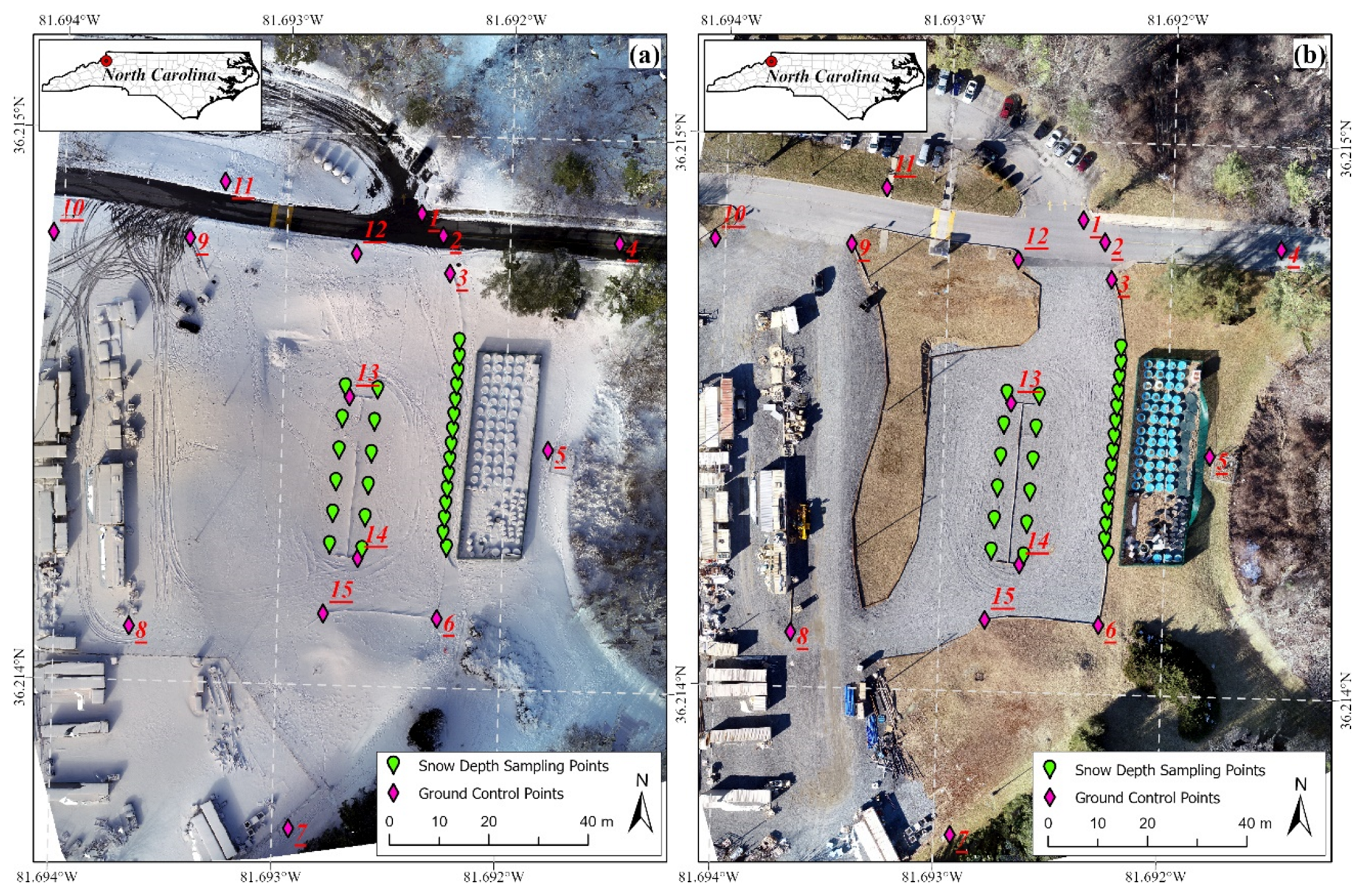
2. Study Area and Data Collection
3. Methodology
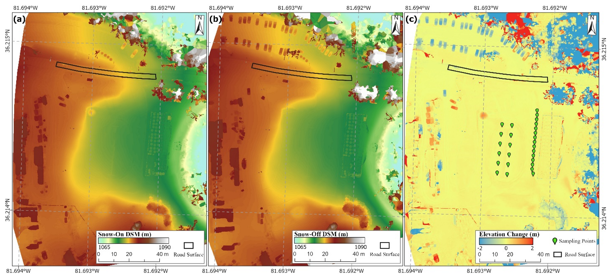
3.1. Generation of DSM and Orthophoto with SfM
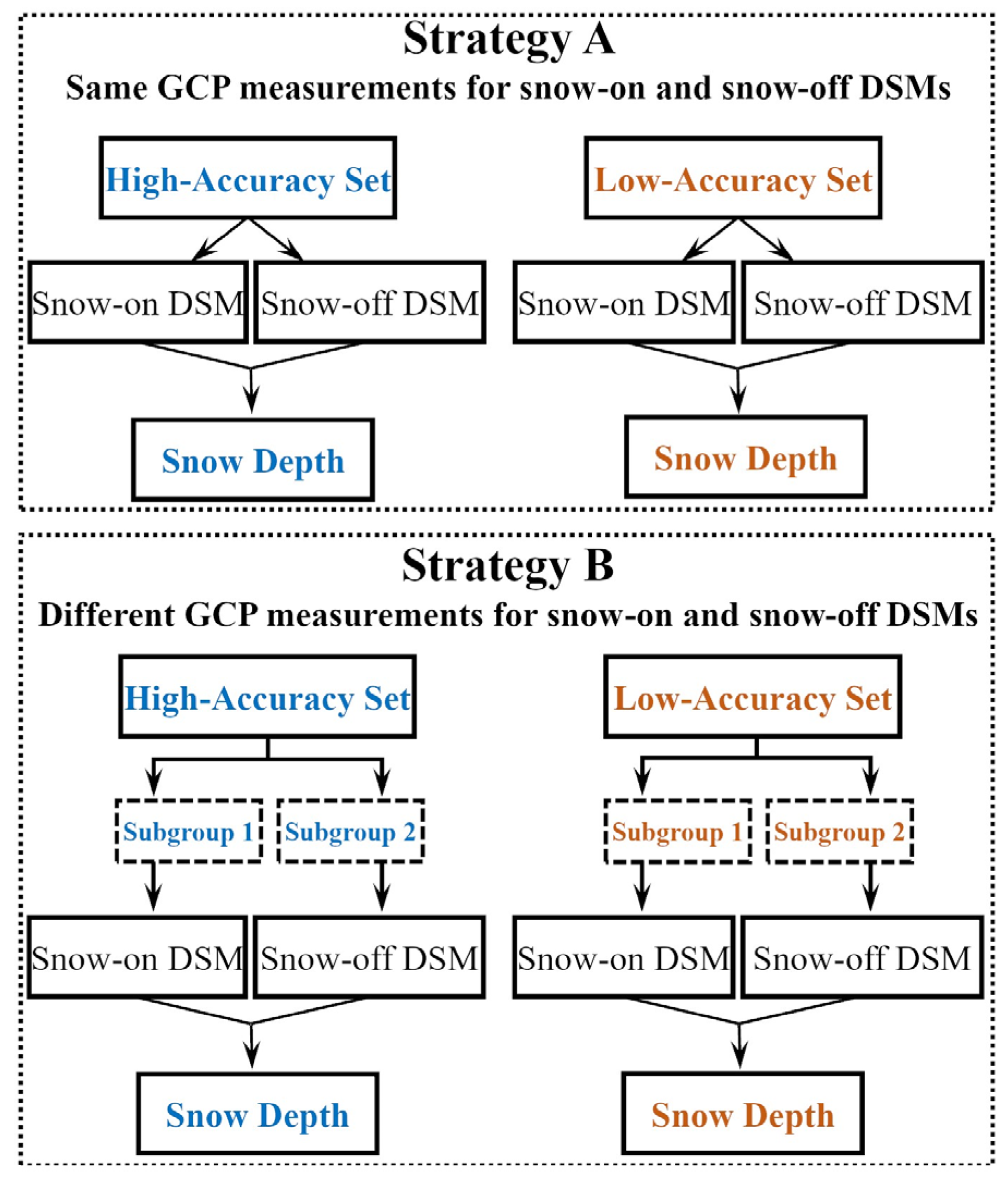
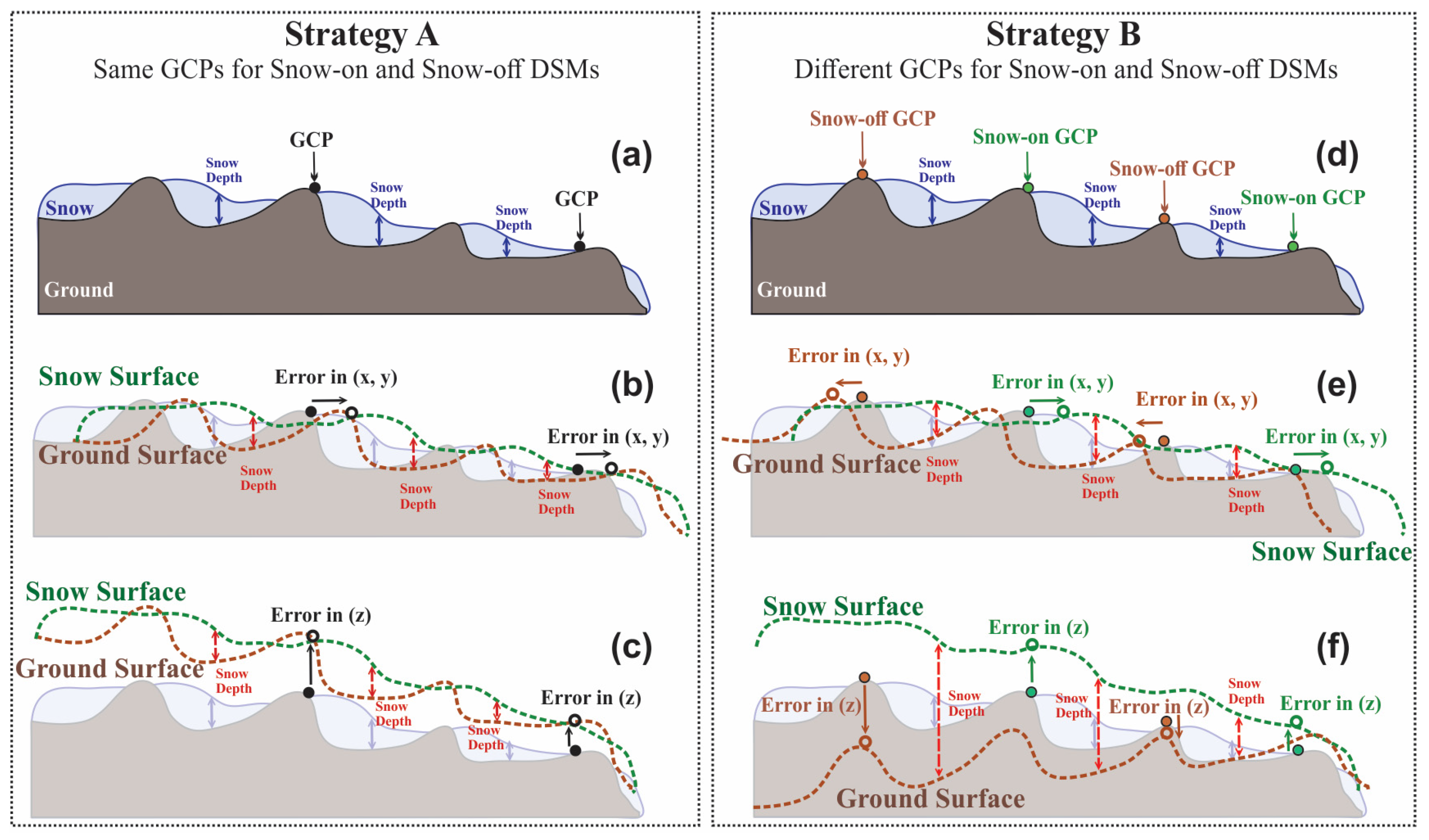
3.2. Strategy of Incorporating GCPs in SfM
3.3. Assessment of SfM-Based Snow Depth Accuracy
4. Results
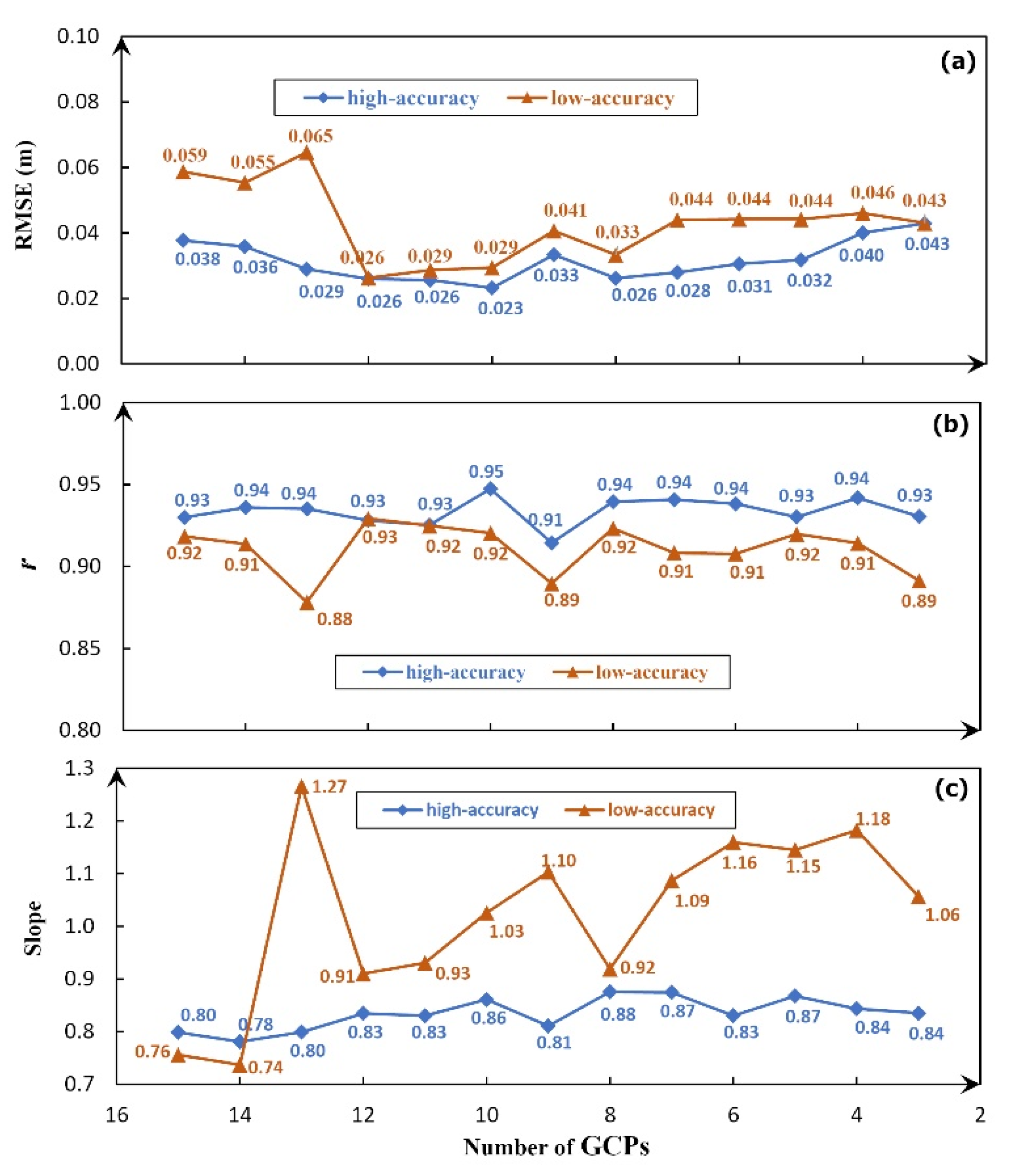
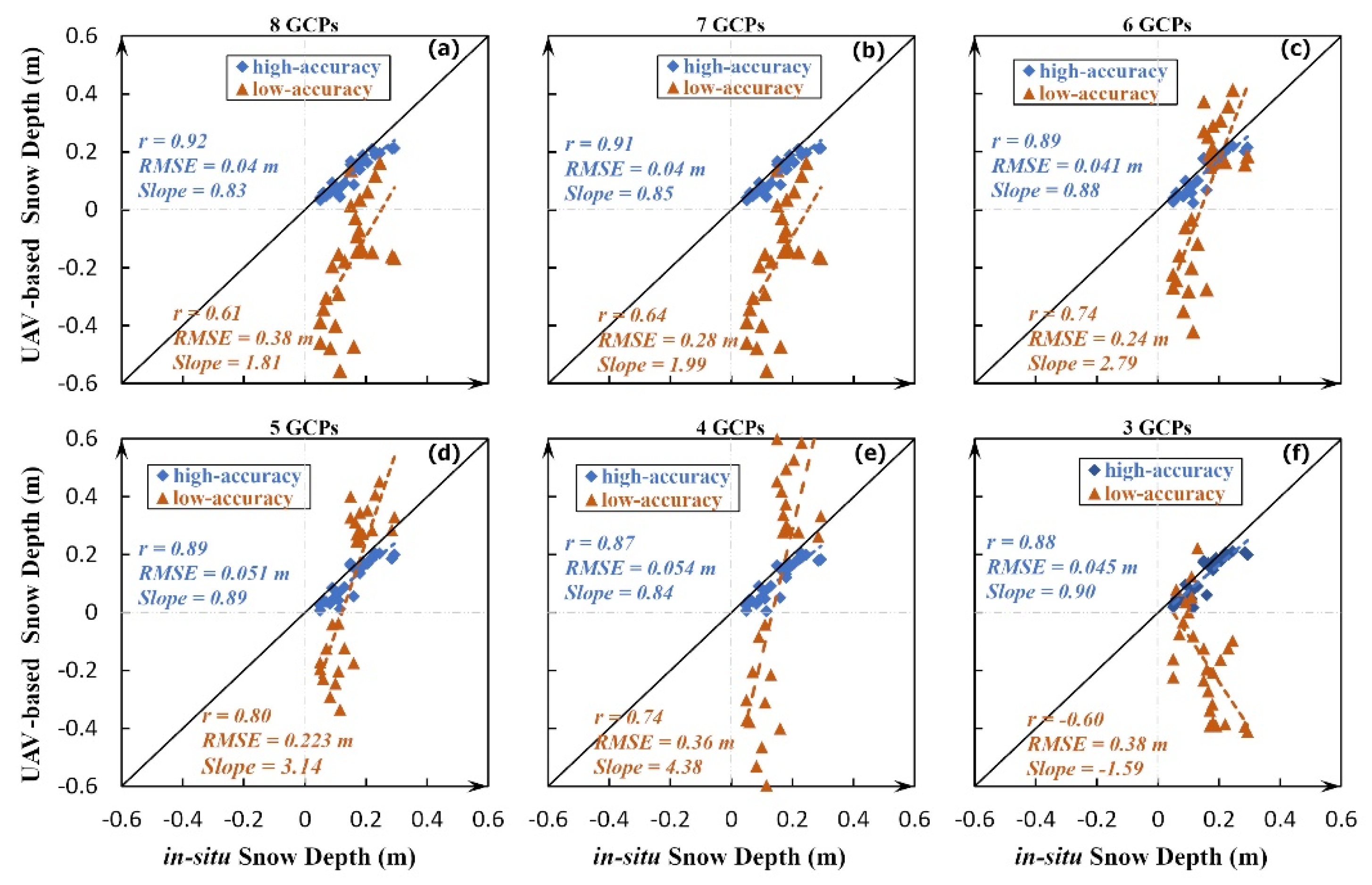
4.1. Strategy A: High-Accuracy Set Verses Low-Accuracy Set
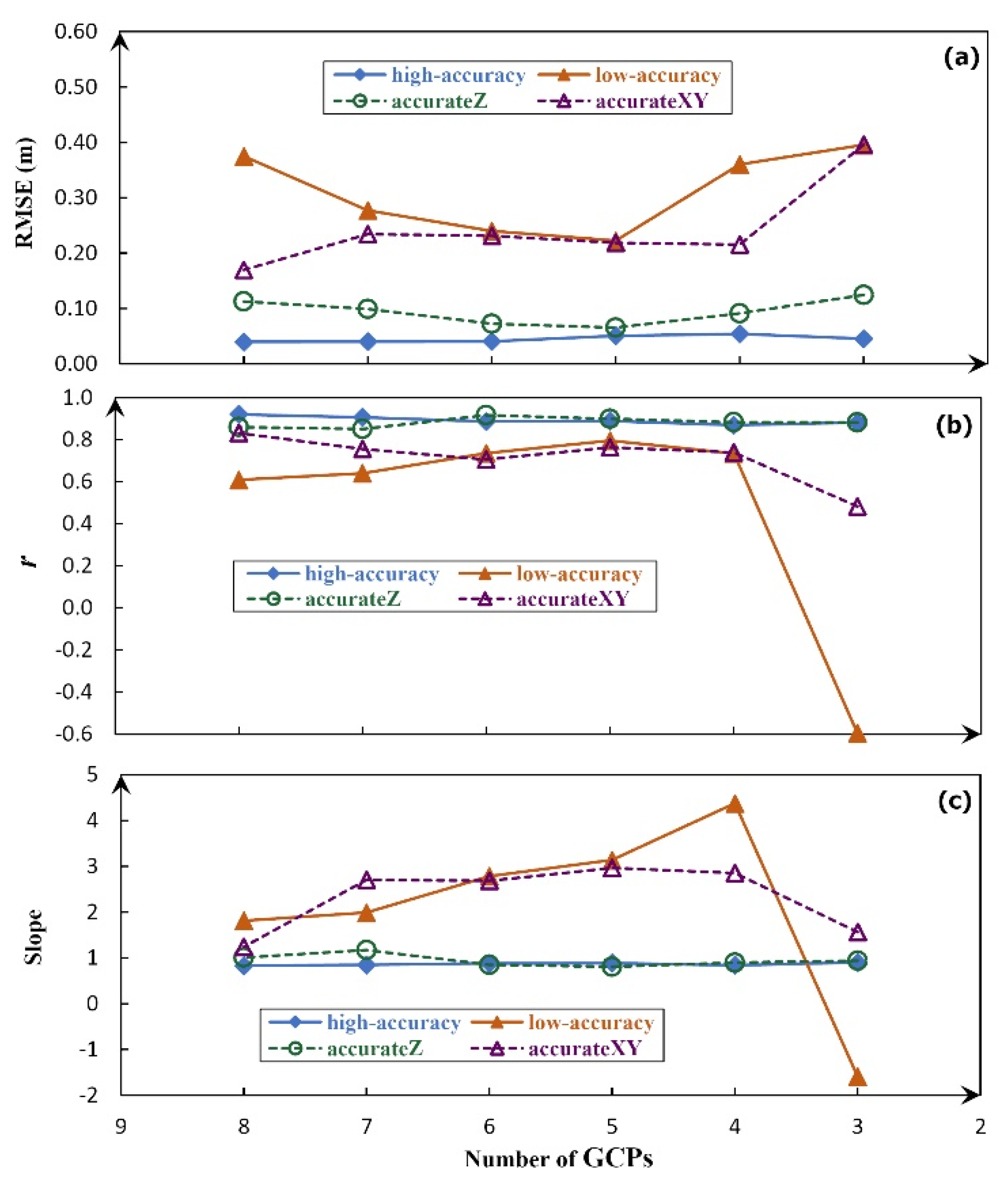
4.2. Strategy B: High-Accuracy Set Verses Low-Accuracy Set
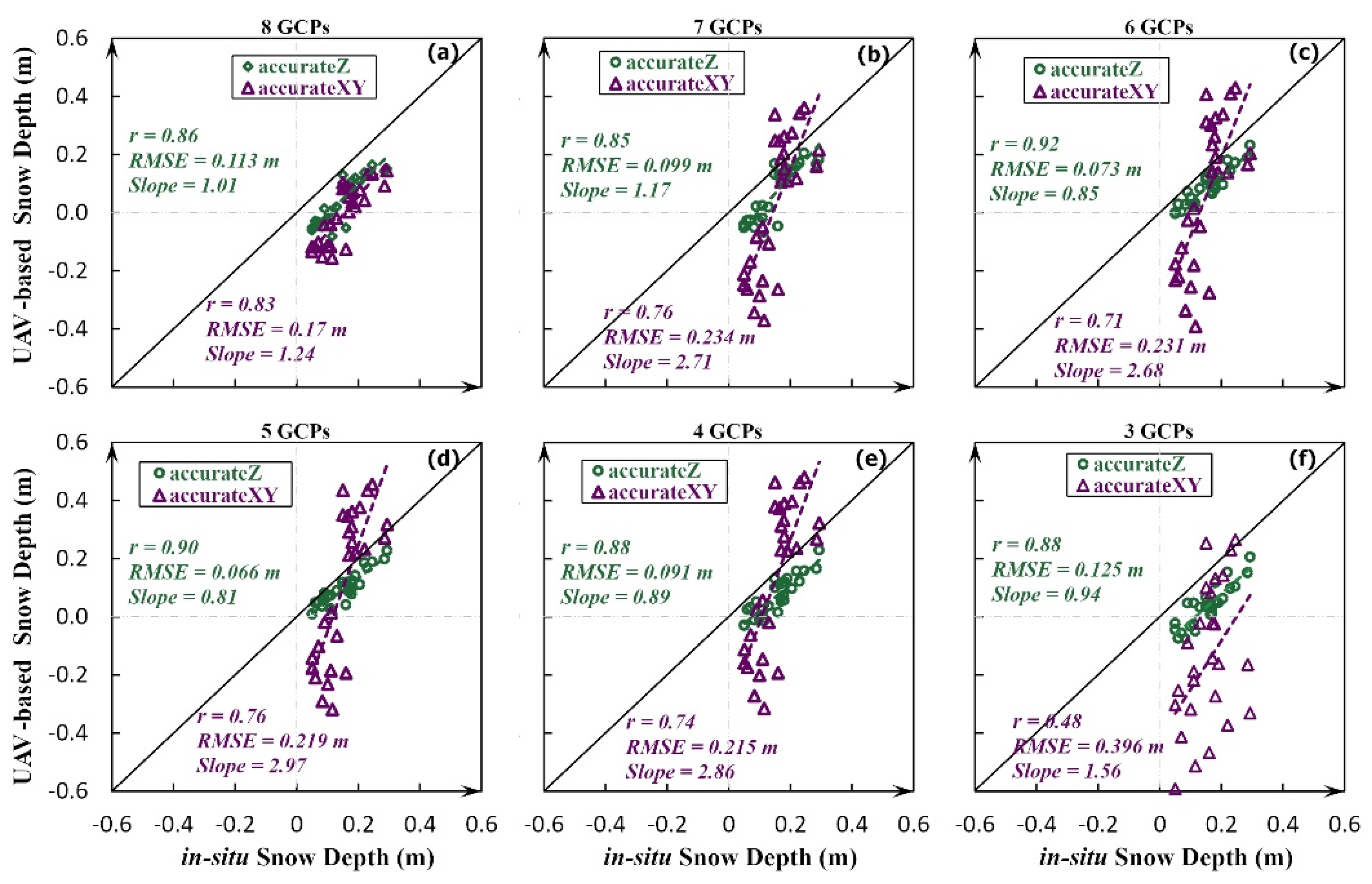
4.3. Strategy B: Accurate-Z Set Verses Accurate-XY Set
5. Discussion
5.1. Influence of GCP Coordinate Errors under Different GCP Deployment Strategies
5.2. Optimal GCP Deployment Strategy for UAV-Based SfM Snow Depth Retrieval
6. Conclusions
Author Contributions
Funding
Data Availability Statement
Conflicts of Interest
References
- Barnett, T.P.; Adam, J.C.; Lettenmaier, D.P. Potential impacts of a warming climate on water availability in snow-dominated regions. Nature 2005, 438, 303–309. [Google Scholar] [CrossRef] [PubMed]
- Kunkel, K.E.; Robinson, D.A.; Champion, S.; Yin, X.G.; Estilow, T.; Frankson, R.M. Trends and Extremes in Northern Hemisphere Snow Characteristics. Curr. Clim. Chang. Rep. 2016, 2, 65–73. [Google Scholar] [CrossRef]
- Dery, S.J.; Brown, R.D. Recent Northern Hemisphere snow cover extent trends and implications for the snow-albedo feedback. Geophys. Res. Lett. 2007, 34. [Google Scholar] [CrossRef]
- Pulliainen, J.; Luojus, K.; Derksen, C.; Mudryk, L.; Lemmetyinen, J.; Salminen, M.; Ikonen, J.; Takala, M.; Cohen, J.; Smolander, T.; et al. Patterns and trends of Northern Hemisphere snow mass from 1980 to 2018. Nature 2020, 581, 294. [Google Scholar] [CrossRef]
- Musselman, K.N.; Addor, N.; Vano, J.A.; Molotch, N.P. Winter melt trends portend widespread declines in snow water resources. Nat. Clim. Chang. 2021, 11, 418. [Google Scholar] [CrossRef]
- Shook, K.; Gray, D. Small-scale spatial structure of shallow snowcovers. Hydrol. Process. 1996, 10, 1283–1292. [Google Scholar] [CrossRef]
- Jonas, T.; Marty, C.; Magnusson, J. Estimating the snow water equivalent from snow depth measurements in the Swiss Alps. J. Hydrol. 2009, 378, 161–167. [Google Scholar] [CrossRef]
- López-Moreno, J.I.; Fassnacht, S.; Heath, J.; Musselman, K.; Revuelto, J.; Latron, J.; Morán-Tejeda, E.; Jonas, T. Small scale spatial variability of snow density and depth over complex alpine terrain: Implications for estimating snow water equivalent. Adv. Water Resour. 2013, 55, 40–52. [Google Scholar] [CrossRef]
- Shu, S.; Liu, H.; Frappart, F.; Huang, Y.; Wang, S.; Hinkel, K.M.; Beck, R.A.; Yu, B.; Jones, B.M.; Arp, C.D.; et al. Estimation of snow accumulation over frozen Arctic lakes using repeat ICESat laser altimetry observations—A case study in northern Alaska. Remote Sens. Environ. 2018, 216, 529–543. [Google Scholar] [CrossRef]
- Chang, A.; Foster, J.; Hall, D. Nimbus-7 SMMR derived global snow cover parameters. Ann. Glaciol. 1987, 9, 39–44. [Google Scholar] [CrossRef]
- Derksen, C.; Walker, A.; Goodison, B. Evaluation of passive microwave snow water equivalent retrievals across the boreal forest/tundra transition of western Canada. Remote Sens. Environ. 2005, 96, 315–327. [Google Scholar] [CrossRef]
- Green, J.; Kongoli, C.; Prakash, A.; Sturm, M.; Duguay, C.; Li, S. Quantifying the relationships between lake fraction, snow water equivalent and snow depth, and microwave brightness temperatures in an arctic tundra landscape. Remote Sens. Environ. 2012, 127, 329–340. [Google Scholar] [CrossRef]
- Kim, R.S.; Durand, M.; Liu, D. Spectral analysis of airborne passive microwave measurements of alpine snowpack: Colorado, USA. Remote Sens. Environ. 2018, 205, 469–484. [Google Scholar] [CrossRef]
- Brucker, L.; Markus, T. Arctic-scale assessment of satellite passive microwave-derived snow depth on sea ice using Operation IceBridge airborne data. J. Geophys. Res. C Ocean. 2013, 118, 2892–2905. [Google Scholar] [CrossRef]
- Kanagaratnam, P.; Markus, T.; Lytie, V.; Heavey, B.; Jansen, P.; Prescott, G.; Gogineni, S.P. Ultrawideband radar measurements of thickness of snow over sea ice. IEEE Trans. Geosci. Remote Sens. 2007, 45, 2715–2724. [Google Scholar] [CrossRef]
- Kurtz, N.T.; Farrell, S.L. Large-scale surveys of snow depth on Arctic sea ice from Operation IceBridge. Geophys. Res. Lett. 2011, 38, L20505. [Google Scholar] [CrossRef]
- Liston, G.E.; Sturm, M. A snow-transport model for complex terrain. J. Glaciol. 1998, 44, 498–516. [Google Scholar] [CrossRef]
- Liston, G.E.; Elder, K. A distributed snow-evolution modeling system (snowmodel). J. Hydrometeorol. 2006, 7, 1259–1276. [Google Scholar] [CrossRef]
- Essery, R.; Pomeroy, J. Vegetation and topographic control of wind-blown snow distributions in distributed and aggregated simulations for an arctic tundra basin. J. Hydrometeorol. 2004, 5, 735–744. [Google Scholar] [CrossRef]
- Snauffer, A.M.; Hsieh, W.W.; Cannon, A.J. Comparison of gridded snow water equivalent products with in situ measurements in British Columbia, Canada. J. Hydrol. 2016, 541, 714–726. [Google Scholar] [CrossRef]
- Broxton, P.D.; Zeng, X.; Dawson, N. Why do global reanalyses and land data assimilation products underestimate snow water equivalent. J. Hydrometeorol. 2016, 17, 2743–2761. [Google Scholar] [CrossRef]
- Wrzesien, M.L.; Durand, M.T.; Pavelsky, T.M.; Howat, I.M.; Margulis, S.A.; Huning, L.S. Comparison of methods to estimate snow water equivalent at the mountain range scale: A case study of the California Sierra Nevada. J. Hydrometeorol. 2017, 18, 1101–1119. [Google Scholar] [CrossRef]
- Deems, J.S.; Painter, T.H.; Finnegan, D.C. Lidar measurement of snow depth: A review. J. Glaciol. 2013, 59, 467–479. [Google Scholar] [CrossRef]
- Lee, S.; Park, J.; Choi, E.; Kim, D. Factors Influencing the Accuracy of Shallow Snow Depth Measured Using UAV-Based Photogrammetry. Remote Sens. 2021, 13, 828. [Google Scholar] [CrossRef]
- Fernandes, R.; Prevost, C.; Canisius, F.; Leblanc, S.G.; Maloley, M.; Oakes, S.; Holman, K.; Knudby, A. Monitoring snow depth change across a range of landscapes with ephemeral snowpacks using structure from motion applied to lightweight unmanned aerial vehicle videos. Cryosphere 2018, 12, 3535–3550. [Google Scholar] [CrossRef]
- Harder, P.; Schirmer, M.; Pomeroy, J.; Helgason, W. Accuracy of snow depth estimation in mountain and prairie environments by an unmanned aerial vehicle. Cryosphere 2016, 10, 2559–2571. [Google Scholar] [CrossRef]
- Vander Jagt, B.; Lucieer, A.; Wallace, L.; Turner, D.; Durand, M. Snow Depth Retrieval with UAS Using Photogrammetric Techniques. Geosciences 2015, 5, 264. [Google Scholar] [CrossRef]
- Cimoli, E.; Marcer, M.; Vandecrux, B.; Bøggild, C.E.; Williams, G.; Simonsen, S.B. Application of low-cost uass and digital photogrammetry for high-resolution snow depth mapping in the Arctic. Remote Sens. 2017, 9, 1144. [Google Scholar] [CrossRef]
- Avanzi, F.; Bianchi, A.; Cina, A.; De Michele, C.; Maschio, P.; Pagliari, D.; Passoni, D.; Pinto, L.; Piras, M.; Rossi, L. Centimetric accuracy in snow depth using unmanned aerial system photogrammetry and a multistation. Remote Sens. 2018, 10, 765. [Google Scholar] [CrossRef]
- Miziński, B.; Niedzielski, T. Fully-automated estimation of snow depth in near real time with the use of unmanned aerial vehicles without utilizing ground control points. Cold Reg. Sci. Technol. 2017, 138, 63–72. [Google Scholar] [CrossRef]
- De Michele, C.; Avanzi, F.; Passoni, D.; Barzaghi, R.; Pinto, L.; Dosso, P.; Ghezzi, A.; Gianatti, R.; Della Vedova, G. Using a fixed-wing UAS to map snow depth distribution: An evaluation at peak accumulation. Cryosphere 2016, 10, 511–522. [Google Scholar] [CrossRef]
- Goetz, J.; Brenning, A. Quantifying Uncertainties in Snow Depth Mapping From Structure From Motion Photogrammetry in an Alpine Area. Water Resour. Res. 2019, 55, 7772–7783. [Google Scholar] [CrossRef]
- Masný, M.; Weis, K.; Biskupič, M. Application of Fixed-Wing UAV-Based Photogrammetry Data for Snow Depth Mapping in Alpine Conditions. Drones 2021, 5, 114. [Google Scholar] [CrossRef]
- Bühler, Y.; Adams, M.S.; Bösch, R.; Stoffel, A. Mapping snow depth in alpine terrain with unmanned aerial systems (UASs): Potential and limitations. Cryosphere 2016, 10, 1075–1088. [Google Scholar] [CrossRef]
- Jiang, S.; Jiang, C.; Jiang, W. Efficient structure from motion for large-scale UAV images: A review and a comparison of SfM tools. ISPRS J. Photogramm. Remote Sens. 2020, 167, 230–251. [Google Scholar] [CrossRef]
- Perry, L.B.; Konrad, C.E. Relationships between NW flow snowfall and topography in the Southern Appalachians, USA. Clim. Res. 2006, 32, 35–47. [Google Scholar] [CrossRef]
- Perry, L.B.; Konrad, C.E.; Hotz, D.G.; Lee, L.G. Synoptic Classification of Snowfall Events in the Great Smoky Mountains, USA. Phys. Geogr. 2010, 31, 156–171. [Google Scholar] [CrossRef]
- Sugg, J.W.; Fuhrmann, C.M.; Perry, L.B.; Hall, D.K.; Konradll, C.E. Sub-regional snow cover distribution across the southern Appalachian Mountains. Phys. Geogr. 2017, 38, 105–123. [Google Scholar] [CrossRef]
- Smith, M.W.; Carrivick, J.L.; Quincey, D.J. Structure from motion photogrammetry in physical geography. Prog. Phys. Geogr. Earth Environ. 2015, 40, 247–275. [Google Scholar] [CrossRef]
- Carrivick, J.L.; Smith, M.W.; Quincey, D.J. Structure from Motion in the Geosciences; John Wiley & Sons: Hoboken, NJ, USA, 2016. [Google Scholar]
- Lowe, D.G. Distinctive image features from scale-invariant keypoints. Int. J. Comput. Vis. 2004, 60, 91–110. [Google Scholar] [CrossRef]
- Lowe, D.G. Object recognition from local scale-invariant features. In Proceedings of the Seventh IEEE International Conference on Computer Vision, Kerkyra, Greece, 20–27 September 1999; Volume 1152, pp. 1150–1157. [Google Scholar]
- Muja, M.; Lowe, D.G. Fast approximate nearest neighbors with automatic algorithm configuration. VISAPP 2009, 2, 2. [Google Scholar]
- Fischler, M.A.; Bolles, R.C. Random sample consensus: A paradigm for model fitting with applications to image analysis and automated cartography. Commun. ACM 1981, 24, 381–395. [Google Scholar] [CrossRef]
- Furukawa, Y.; Ponce, J. Accurate, dense, and robust multiview stereopsis. IEEE Trans. Pattern Anal. Mach. Intell. 2009, 32, 1362–1376. [Google Scholar] [CrossRef] [PubMed]
- Cohen, I.; Huang, Y.; Chen, J.; Benesty, J.; Benesty, J.; Chen, J.; Huang, Y.; Cohen, I. Pearson correlation coefficient. In Noise Reduction in Speech Processing; Springer: Berlin/Heidelberg, Germany, 2009; pp. 1–4. [Google Scholar]
- Lendzioch, T.; Langhammer, J.; Jenicek, M. Estimating Snow Depth and Leaf Area Index Based on UAV Digital Photogrammetry. Sensors 2019, 19, 1027. [Google Scholar] [CrossRef]
- Krichen, M.; Adoni, W.Y.H.; Mihoub, A.; Alzahrani, M.Y.; Nahhal, T. Security Challenges for Drone Communications: Possible Threats, Attacks and Countermeasures. In Proceedings of the 2022 2nd International Conference of Smart Systems and Emerging Technologies (SMARTTECH), Riyadh, Saudi Arabia, 9–11 May 2022; pp. 184–189. [Google Scholar]
- Ko, Y.; Kim, J.; Duguma, D.G.; Astillo, P.V.; You, I.; Pau, G. Drone Secure Communication Protocol for Future Sensitive Applications in Military Zone. Sensors 2021, 21, 2057. [Google Scholar] [CrossRef]

| Step | Number of GCPs Incorporated | GCPs Incorporated in Strategy A | GCPs Incorporated in Strategy B | |
|---|---|---|---|---|
| Snow-On/Snow-Off | Subgroup1: Snow-On | Subgroup2: Snow-Off | ||
| 1 | 15 | 1–15 | ||
| 2 | 14 | 1–3, 5–15 | ||
| 3 | 13 | 1–3, 6–15 | ||
| 4 | 12 | 1–3, 6–9, 11–15 | ||
| 5 | 11 | 1–3, 6, 8, 9, 11–15 | ||
| 6 | 10 | 1, 3, 6, 8, 9, 11–15 | ||
| 7 | 9 | 1, 3, 6, 8, 9, 12–15 | ||
| 8 | 8 | 3, 6, 8, 9, 12–15 | 1, 3, 4, 6, 7, 9, 13, 15 | 2, 5, 6, 8, 10, 11, 12, 14 |
| 9 | 7 | 3, 6, 8, 9, 12, 13, 15 | 1, 4, 6, 7, 9, 13, 15 | 2, 5, 6, 8, 11, 12, 14 |
| 10 | 6 | 3, 6, 8, 9, 12, 15 | 1, 4, 6, 9, 13, 15 | 2, 6, 8, 11, 12, 14 |
| 11 | 5 | 3, 6, 8, 9, 15 | 1, 6, 9, 13, 15 | 2, 6, 8, 11, 14 |
| 12 | 4 | 3, 6, 8, 9 | 1, 6, 9, 15 | 2, 6, 8, 11 |
| 13 | 3 | 3, 6, 8 | 1, 9, 15 | 2, 6, 8 |
Disclaimer/Publisher’s Note: The statements, opinions and data contained in all publications are solely those of the individual author(s) and contributor(s) and not of MDPI and/or the editor(s). MDPI and/or the editor(s) disclaim responsibility for any injury to people or property resulting from any ideas, methods, instructions or products referred to in the content. |
© 2023 by the authors. Licensee MDPI, Basel, Switzerland. This article is an open access article distributed under the terms and conditions of the Creative Commons Attribution (CC BY) license (https://creativecommons.org/licenses/by/4.0/).
Share and Cite
Shu, S.; Yu, O.-Y.; Schoonover, C.; Liu, H.; Yang, B. Unmanned Aerial Vehicle-Based Structure from Motion Technique for Precise Snow Depth Retrieval—Implication for Optimal Ground Control Point Deployment Strategy. Remote Sens. 2023, 15, 2297. https://doi.org/10.3390/rs15092297
Shu S, Yu O-Y, Schoonover C, Liu H, Yang B. Unmanned Aerial Vehicle-Based Structure from Motion Technique for Precise Snow Depth Retrieval—Implication for Optimal Ground Control Point Deployment Strategy. Remote Sensing. 2023; 15(9):2297. https://doi.org/10.3390/rs15092297
Chicago/Turabian StyleShu, Song, Ok-Youn Yu, Chris Schoonover, Hongxing Liu, and Bo Yang. 2023. "Unmanned Aerial Vehicle-Based Structure from Motion Technique for Precise Snow Depth Retrieval—Implication for Optimal Ground Control Point Deployment Strategy" Remote Sensing 15, no. 9: 2297. https://doi.org/10.3390/rs15092297
APA StyleShu, S., Yu, O.-Y., Schoonover, C., Liu, H., & Yang, B. (2023). Unmanned Aerial Vehicle-Based Structure from Motion Technique for Precise Snow Depth Retrieval—Implication for Optimal Ground Control Point Deployment Strategy. Remote Sensing, 15(9), 2297. https://doi.org/10.3390/rs15092297


