1. Introduction
Underground irrigation systems in Afghanistan and Central Asia are known as “Kariz”. In Xinjiang, China, it is called “karez” in the Uyghur language. In “Shiji” (Records of the Grand Historian of China), it is recorded as “Jingqu” (well and canal). In Persian, it is referred to as “Kanatz-qanat”, while in Iran, it is now called “Qanat” [
1]. In Pakistan, it is known as “Karezes”, while in North Africa, it is referred to as “Foggaras”. In the United Arab Emirates, it is known as “Aflaj” [
2,
3]. As the “karez” system is known as such in the Uyghur language, this study will use “karez” to describe the system.
Karezes are a unique testament to the traditional culture and civilization of the desert in an arid climate. China’s karezes were added to the Tentative List of World Cultural Heritage of China in 2008, meeting the Criteria: (I)(IV)(V) [
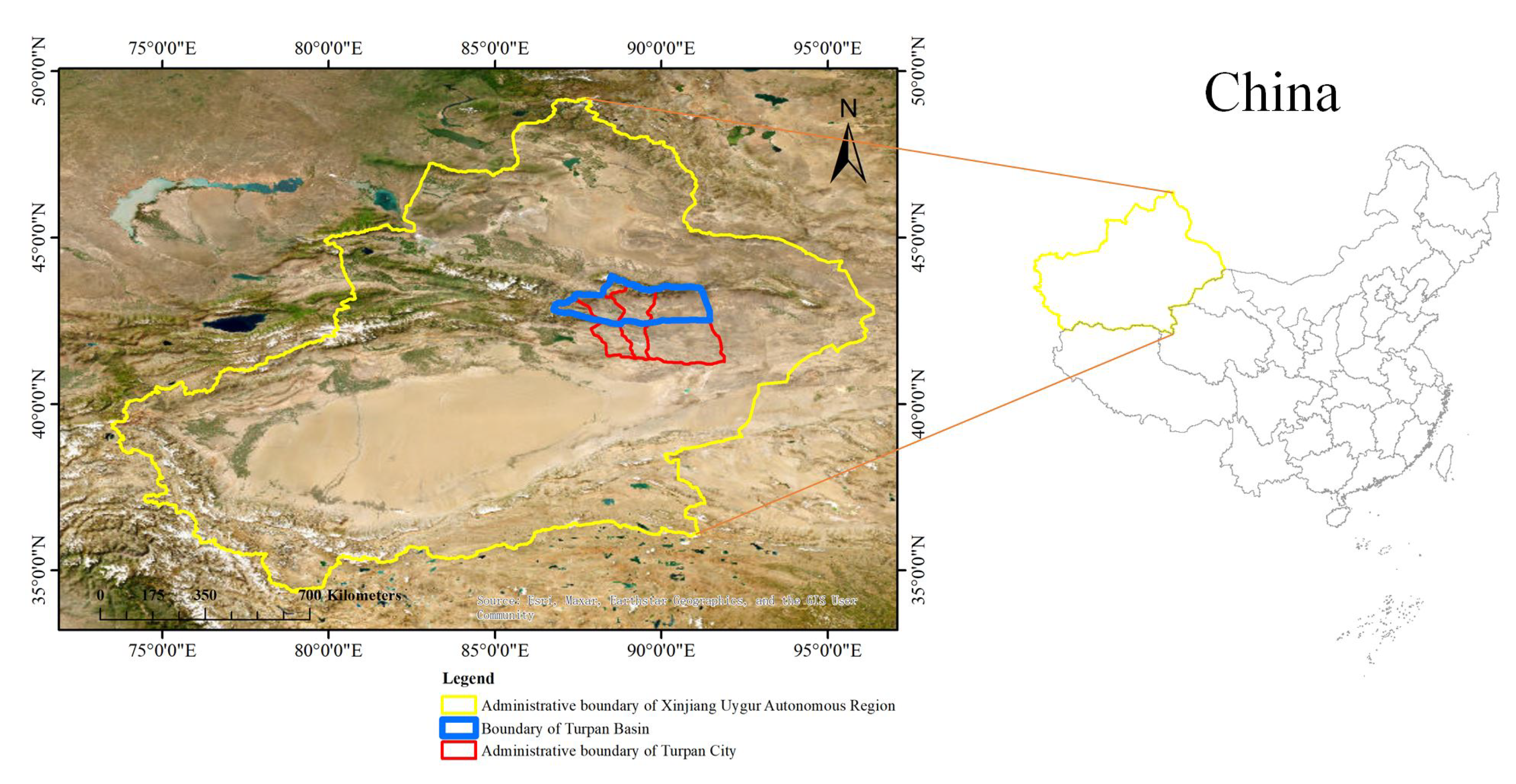
4]. Karez systems are mainly concentrated in the Tuha Basin of Xinjiang, with the Turpan Basin’s karez systems having a long history. The number of karez systems in Turpan varies over time, with 1237 channels in 1957. With a history dating back 4000 years, Turpan was once the country of Che Shi 1000 years before the 1st century BC, with the ancient city of Jiaohe as its capital city. From the 1st to the 8th centuries, it was under Han rule, while from the 9th to the 18th centuries, it was the era of the Uighur people. From the Qing Dynasty up to the present, it has been a society of public development for all ethnic groups. Radiocarbon
dating of eight karez systems in Turpan by Bertil et al. showed that the oldest investigated karez systems originated in the Uyghurian Huihe dynasty (790-1755 AD) [
5], indicating that the karez systems in Turpan were created by the local Uyghur people.
Iran has over 30,000 karez systems [
1], with 11 Karez systems inscribed on the UNESCO’s World Heritage List in 2016. The inclusion criteria were: (iii)(iv) [
6]. The Iranian property of the 11 karezes covers an area of 19,057 hectares, and the buffer zone covers an area of 351,343 hectares. Similar to karezes, Aflaj is connected to the natural groundwater level and relies on gravity to pipe groundwater to the villages [
7]. The aflaj subterranean tunnel-well system is the most common form of water management in Oman. Historical and archaeological evidence suggests that ancient Greece developed karez-related technology since Classical Times [
8].
The landscape of desert cities is fragile, and the karez water conservancy structure represents the ecological wisdom of Iran’s Yazd desert city. Environmental planning based on socio-economic methods emphasizing water resources is also an ecological wisdom [
9]. Moghadam et al. studied karez water recharge using chemical isotopes and hydrogeological evidence, focusing on six karezes in eastern Iran [
10]. Naghedifar et al. [
11] developed a numerical simulation model of the karez groundwater system, while Sedghi et al. [
12] obtained the solution of the Laplace domain of flow variation of karezes recharged by aquifers under anisotropic unconstraint. Kazemi et al. [
13] conducted a health risk assessment study of total chromium in the karezes, which is a historical drinking water supply system. Pueppke [
14] reviewed the relationship between water-energy-food in the distant past. The type of land use/land cover is related to the energy exchange of the surface atmosphere and determines the water and carbon exchange between the land and the atmosphere. Accurate land surface conditions are fundamental to environmental and climate research.
Mirani Moghadam et al. [
15] analyzed the flow changes of four karezes in eastern Iran over the past 33 years and discussed the factors influencing the changes in karez flow. They showed that since 2000, there has been a significant decrease in precipitation in the study area, while the amount of groundwater pumped through deep wells has increased since 1960 due to the consumption of drinking water and agricultural water, leading to a drop in the groundwater table of 0.1 m per year. The flow rate of the karezes has decreased from 38 L/s to 9 L/s over the past 33 years. At the current rate of groundwater table decline, the four karezes (Rahn, Baidokht, Kheshuie, and Qasabeh) in eastern Iran will disappear in 9–157 years. Therefore, it is necessary to control groundwater extraction and limit water consumption in industry and agriculture [
15]. Velasco-Sánchez et al. [
16] analyzed changes in soil chemistry in the ancient karez-irrigated agricultural area of southern Jordan. Kowkabi [
17] studied ways to restore karezes in Iran to create public open spaces and enhance the quality of social life in urban areas. Delfani et al. [
18] studied the thermal effects of karez-source heat pumps. Using the Baladeh karez in eastern Iran as a test area, the impact of suspended solids on water loss during water transport was investigated, and three channels were tested, including the farmland channel, the hand-built channel, and the Baladeh irrigation channel [
19]. Barbaix et al. [
20] focused on the study of karezes and their location characteristics, using CORONA KH4B, Landsat 8, and Pleiades1 remote sensing imagery to find landscape types of karez, settlements, and vegetation locations. Manian et al. [
21] analyzed the risk of COVID-19 transmission in the Kashan karez-irrigated agricultural area. Keramati et al. [
22] compared the concentration of radon 222 in drinking water from spring, well, karez, and tap water, and assessed the health risks of different intakes to adults and children using Monte Carlo simulation (MCS) technology. Ghosh et al. [
23] reviewed the risk assessment and treatment measures of coastal aquifer vulnerability to saltwater intrusion and pointed out that Abstraction Desalinization Recharge (ADR) and karez structures can effectively reduce the risk of saltwater intrusion in groundwater extraction areas. However, Sudip et al. [
24] reviewed the risks and management techniques associated with saltwater intrusion into coastal aquifers and pointed out that karez structures, shallow, and deep machine wells may be ineffective in reducing seawater intrusion in coastal zone areas because the principle of saltwater intrusion is not fully understood. Samani et al. [
25] used five widely used supervised machine learning models to predict the flow rate of karezes with accuracy evaluation indicators, including correlation coefficient, Nash–Sutcliffe efficiency (NSE), RMSE (root means squared error), and MAE (mean absolute error). Karami et al. [
26] studied the transient performance of karez source heat pumps using the TRNSYS-MATLAB joint simulator. Sedghi et al. [
27] analyzed the semi-analytical solution of flow changes in karezes in alluvial fan aquifers.
Remote sensing archaeology provides a new technological means for archaeology, expanding the temporal and spatial scope of archaeological research. Spatial archaeology is a new paradigm of remote sensing archaeology [
28]. Luo et al. [
29] summarized the progress of aerospace technology applied to archaeology and cultural heritage over the past century and analyzed the application of ground observation technology in archaeology. Yang et al. [
30] used improved Deeplabv3+ and aerial images to automatically extract the Han Great Wall in northwest China, demonstrating the potential of artificial intelligence in remote sensing interpretation. The United Nations’ 2030 Agenda for Sustainable Development provides an important guiding framework for economic, social, and environmental development [
31]. The Big Earth Data Platform can provide data and methods for assessing various sustainable development indicators. Big data and artificial intelligence technology provide new methods for scientific discovery, and the Big Earth Data Project offers a new paradigm for the study of Earth science [
32,
33,
34].
The term land use emphasizes the transformation of land types by human society, while land cover refers to the types of land formed by natural environments or human activities [
35]. As two-thirds of China’s territory is mountainous, changes in land use and land cover are closely related to mountain hazards. Predicting future land use based on historical land use types can provide guidance for the development and utilization of land. Maghrebi et al. [
36] used remote sensing techniques to investigate land use/land cover changes in the Mashhad Plain in northern Iran over the past 60 years and the disappearance of 15,983 karezes, showing that only 5.59% of karezes in 1961 were intact in 2021. The most significant land use/land cover changes affecting karezes were agriculture and urban areas, which accounted for 42.93% and 31.81% of karez shaft destruction, respectively. Halik [
37] analyzed the impact of spatiotemporal changes in land use/land cover on karez in the Turpan Basin and found that the area of arable land and construction land continued to increase while the water area decreased. This analysis, which used TM/ETM+ images of 1990, 2000, and 2010, directly or indirectly affected the survival of karezes [
37]. Yang et al. [
38] produced the China land cover dataset (CLCD) with an annual resolution of 30 m using Landsat images and the Google Earth Engine (GEE) platform. They utilized random forests, spatiotemporal filtering, and logical reasoning post-processing methods, achieving an accuracy of 79.31%, which exceeded that of MCD12Q1, ESACCI_LC, FROM_GLC, and GlobeLand30.
Laugier et al. [
39] explored the historical land use/land cover of the Upper Diyala/Sirwan River in the Kurdistan Region of Iraq, utilizing satellite remote sensing combined with historical imagery from multispectral sensors of the drone platform and ground geophysical detection. The study revealed that canals, karezes, trackways, and field systems date back to the first millennium CE. Valipour et al. [
40] sorted out the sustainable use of groundwater resources from ancient to modern times and even the future, introducing hydrological techniques from Prehistoric Times (3200 BC–1000 BC), Historical Times (1000 BC–330 AD), Medieval Times (ca 330–AD1400), Early and Mid-Modern Times (ca 1400–1900 AD), to Contemporary Times (1900 AD–Present). Climate change or overexploitation may lead to a water crisis. Sayadi et al. [
41] conducted a risk assessment of cadmium (Cd) and chromium (Cr) content and growth of edible herbs (Adiantum capillus-verenis, Chara globularis, and Plantago lanceolata) in karez water in 14 villages in the South Khorasan province of Iran from April to August 2018. Assessing the channel stability of karezes under railway pressure is essential as some high-speed railways inevitably pass through the karez area. Zhang et al. [
42] used a series of RAFELA (random adaptive finite element limit analysis) methods to investigate the stability of karez channels in cohesive-frictional soils. Ebrahimi et al. [
43] reviewed the geoengineering and environmental impacts of the karez system, focusing on determining the location, geometry, depth, and underground passages of karez. Geophysical electrical resistivity tomography (ERT), ground-penetrating radar (GPR), and electromagnetic (EM) methods are commonly used when probing underground pipes and other structural parameters of karezes.
The karez systems in Turpan are a unique form of irrigation that have been used for over 600 years at least. However, in recent years, due to changes in land use and climate, the karez systems have faced serious challenges, such as drying up and collapsing. Therefore, it is of great significance to study the changes in the karez systems and the impact of land use changes on the karez systems. At present, remote sensing technology has become an important means of studying land use changes and the karez systems. The use of high-spatial-resolution remote sensing images to automatically extract the karez systems and study their land use changes can provide important reference data for the rational use and protection of the karez systems. Additionally, understanding the impact of land use changes on the karez systems can provide guidance for the sustainable development of the local economy and agriculture in Turpan. Therefore, the study of the changes in the karez systems and the impact of land use changes on the karez systems is of great significance for the protection and sustainable use of this valuable cultural heritage, as well as for the local economy and agriculture in Turpan.
3. Methods
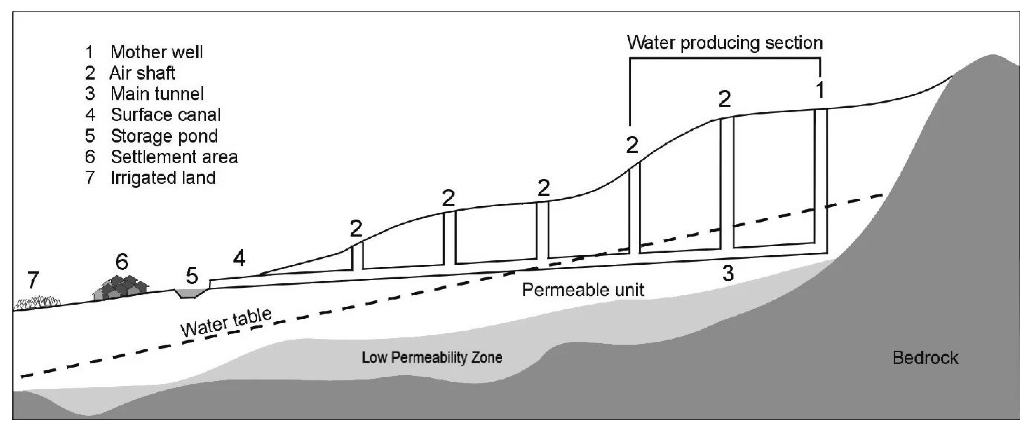
A karez is an ancient underground canal irrigation system mainly distributed in the Turpan area of Xinjiang, China. Its structure consists of a mother well, vertical wells, dragon mouths, open canals, and water tanks, as shown in
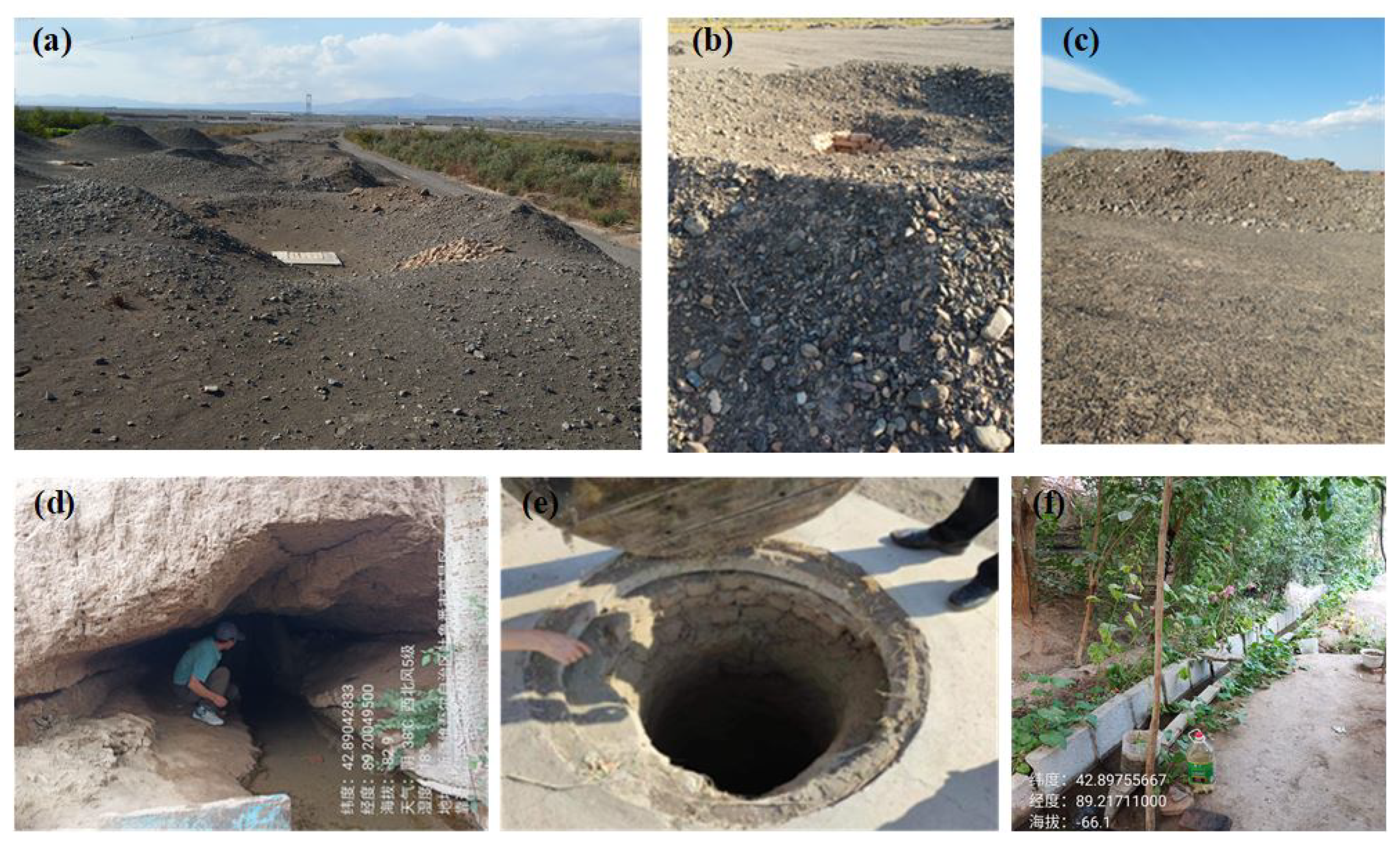
Figure 2. The vertical wells are typically circular in shape, with a diameter of several meters. The mother well is located at the upstream end of the karez system and is dug beneath the water-bearing layer to divert groundwater into the underground canal. The principle of a karez is to use underground water to enter the mother well and then introduce water into the dragon mouths and open canals through the underground canal, ultimately irrigating farmland or providing water for people’s daily life. The functions of the karez’s vertical wells include: excavating the soil during the construction of the underground canal, providing ventilation and lighting, determining the direction of the underground canal, providing access for karez craftsmen and maintenance personnel to enter and exit the underground canal, providing tools for the workers in the underground canal, and lifting various equipment. Some vertical wells have well covers to prevent pollution and ensure safety. Open canals are the main channels for directing water to farmland or residential areas, and water can also be stored in water tanks. The advantages of the karez system include water resource conservation, adaptation to arid environments, and minimal energy consumption. A field scene of the karez system is shown in
Figure 3.
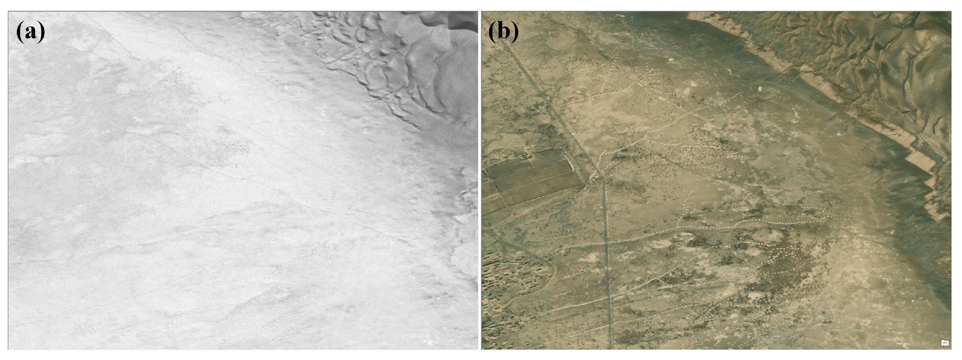
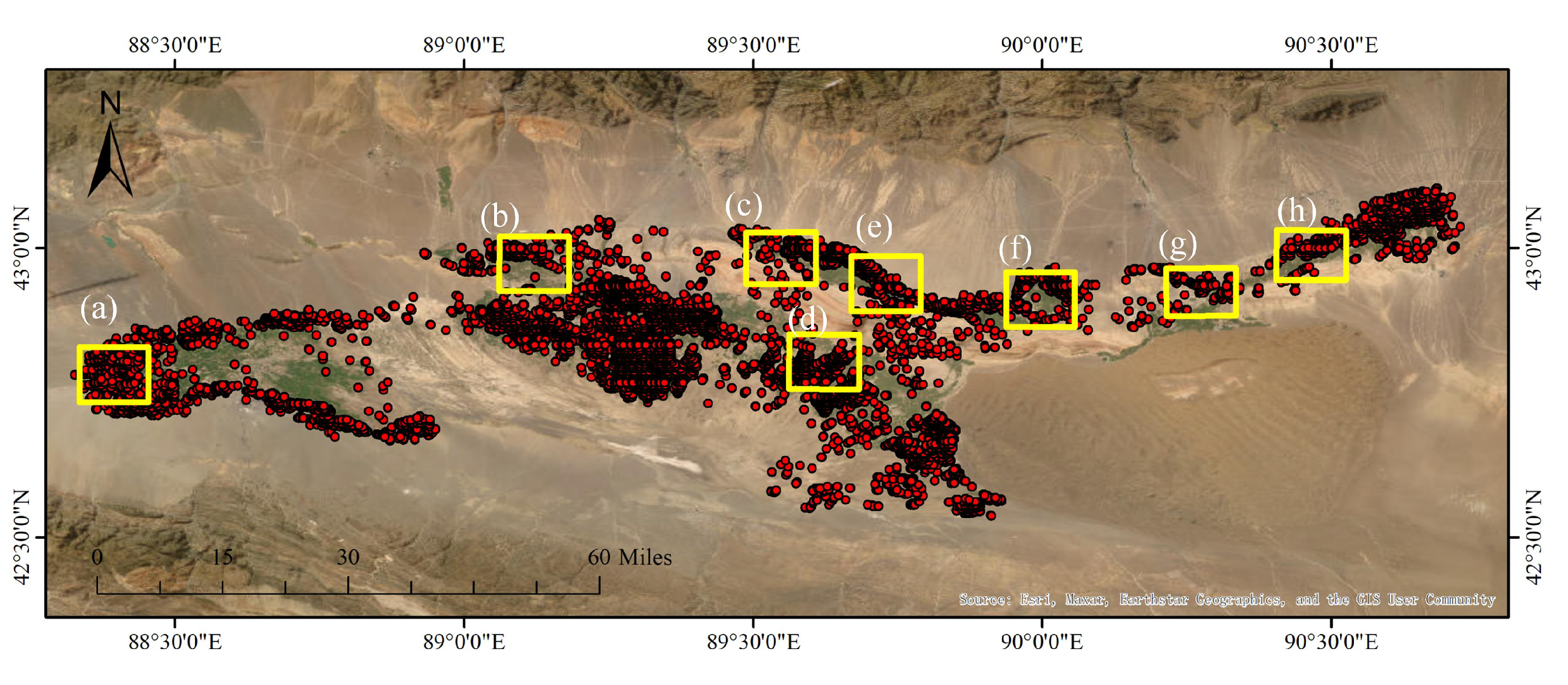
Figure 4 shows that only the vertical wellheads of the karez system are visible on the ground surface and remote sensing images, as the other parts of the karez system are located underground. When mapping the karez system, the vertical wells are abstracted as point features, which is a common practice in geographic information systems (GIS). Discrete features, such as points, lines, and polygons, are used to represent real-world objects in GIS. The location of each vertical well is recorded as a point on the map, enabling the visualization and analysis of the spatial distribution of the karez system. By abstracting the vertical wells as point features, the map can effectively communicate the location and density of the karez system, which is useful for understanding the hydrological and cultural significance of this ancient irrigation system.
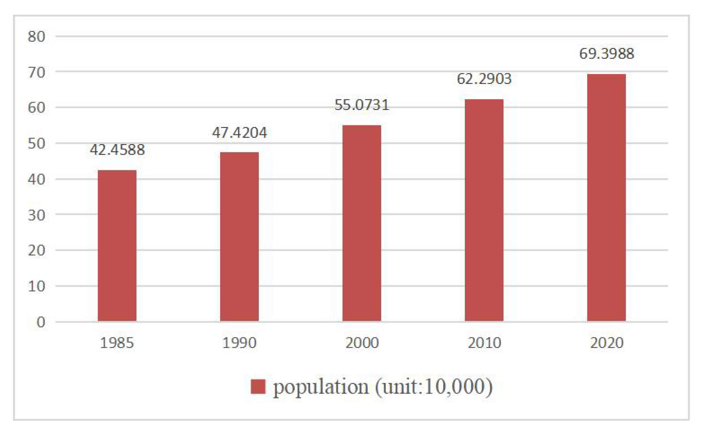
The development process of a karez in Turpan can be broadly divided into three stages. The first stage was the slow development stage, which lasted from 1782 to 1845. During this period, the number of karez was limited by the historical population and socio-economic development level, and by the Daoguang period of the Qing Dynasty, the number of karez had grown to close to 300. The second stage was the growth stage, which lasted from 1845 to 1957. After Lin Zexu was demoted to Xinjiang in the 25th year of Daoguang in the Qing Dynasty, he made significant contributions to the development of karezes in Turpan, and by 1912, the early years of the Republic of China, the number of karezes in Turpan had increased to 1060. The third stage was the attenuation stage, which started from 1957 to the present. Since the construction of the first Tianshan system diversion canal in 1957, the water replenishment of karezes has decreased, and the number of karezes has sharply declined from 1237 channels [
54]. In the context of climate change, urbanization, and modern technology, the number of mechanical and electrical wells in Turpan has gradually increased, the population has grown, and towns and arable land have expanded. In eastern Xinjiang, temperatures have risen, and precipitation has increased over the past 50–60 years. The Bogda and Miaoergou glaciers have also retreated [
55].
Li et al. [
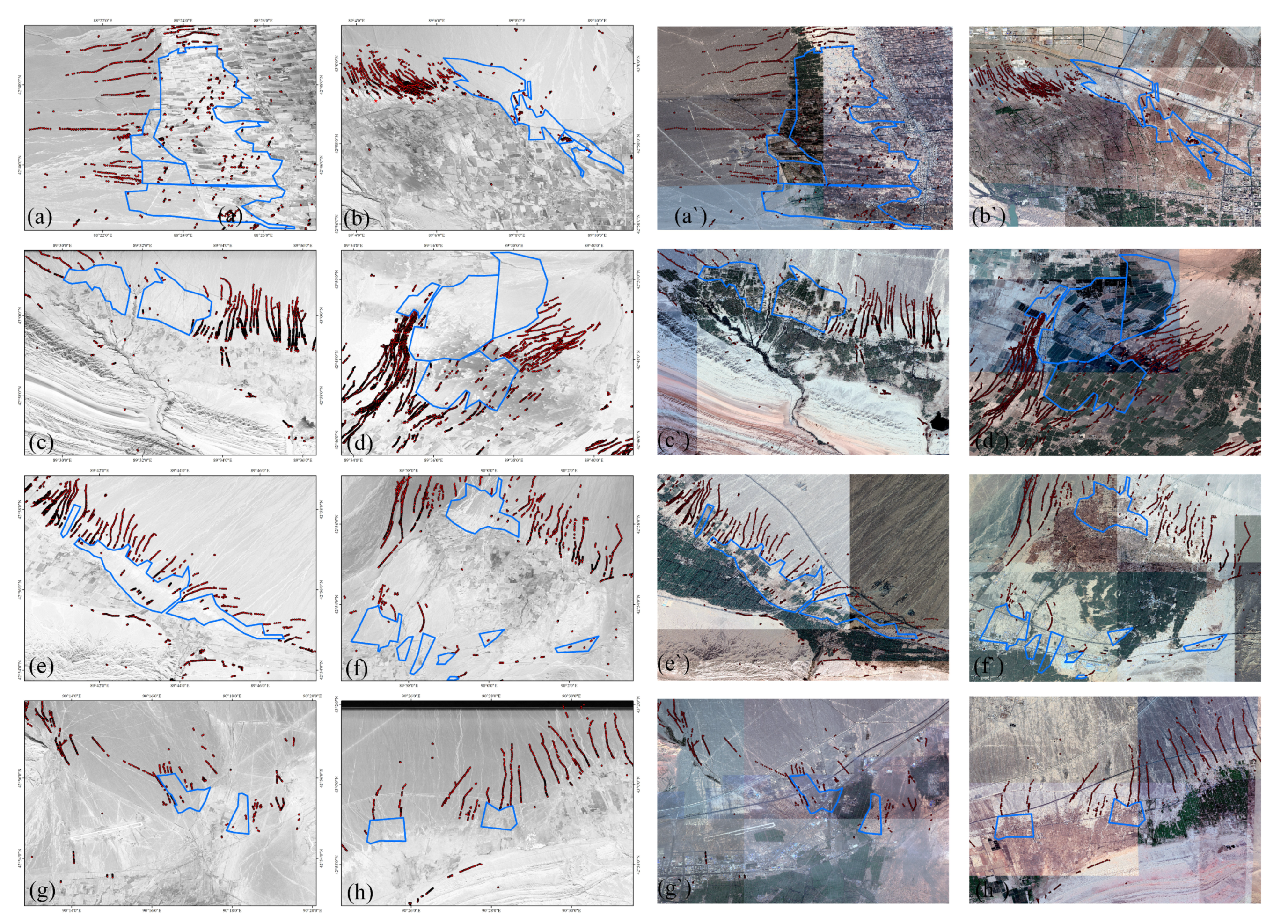
56] utilized the YOLOv5 model and post-processing steps to extract the karez shaft distribution map of the karez system in 2020 using Google Earth imagery. By overlaying the karez map of 2020 with the CORONA image, the karez area can be quickly located using the 2020 karez map as the target area. Although some parts of the karez system may have been abandoned between 1979 and 2020, most of the shafts of the karez system still exist. The karez system is primarily used for the irrigation of farmland and domestic water supply, so the wells are distributed around cultivated land and villages. Therefore, the karez well map in 2020 and spatial distribution characteristics serve as prior knowledge for the visual interpretation of karez wells on the CORONA imagery. Using CORONA images as the data source, this study analyzes the distribution of karezes in the 1970s through visual interpretation and compares it with the distribution of karezes in 2020 to analyze changes in the karez system. The study also obtains the land use/land cover transfer matrix of the Turpan Basin in the past 40 years by analyzing the land use/land cover changes in the region and explores the impact of land use/land cover change on the karez system. When comparing different maps, the projection method should be consistent. Based on the longitude range of Turpan, the study area of this article, the projection is UTM projection with zone number 45N, and the geodetic datum is WGS84. The technical route flowchart of this study is presented in
Figure 5.
3.1. CORONA Images Processing
The CORONA images downloaded from USGS are not strictly georeferenced, as they only provide the four-solstices coordinates of the image, which are not particularly accurate. In order to ensure that remote sensing images of different time phases can be superimposed and analyzed, geometric correction is necessary. The preprocessing of the CORONA images includes intra-scene stitching and georeferencing. In single-scene stitching, the pixel difference of overlapping left and right, upper and lower edges is calculated using ENVI, and then splicing is carried out based on the PIL module of the Python program. Georeferencing is based on very high-resolution Google Earth imagery. The ArcGIS georeferencing tool is used for correction, and the correction method adopts the spline model, which requires the number of GCPs (Ground Control Points) to be greater than 10. The control point error is 0, and the number of control points for each image is shown in
Table 1. Spline functions are piecewise polynomial functions that guarantee continuity and smoothness between adjacent polynomials. Spline functions accurately transform source control points to target control points. The higher the number of control points, the higher the overall accuracy of the spline transformation. The number of karez systems included in different imagery varies, and only the target area of this study, i.e., the region where karez systems exist, is accurately spine-corrected when performing geometric correction on CORONA imagery. Therefore, the number of control points used for correction varies significantly between different images. The resampling method uses Nearest Neighbor.
3.2. Karez Change
This study conducted a statistical analysis of the number of active and inactive karez systems at the township administrative level for the 2000s and 2010s. The linear feature was used as the statistical unit, with each karez system counted as one unit, and the change in the number of karez systems between these two time periods was analyzed. Visual interpretation was used to analyze the changes in the vertical shafts of karez systems between CORONA imagery and the shafts in 2020 extracted by Li et al. [
56]. Additionally, we calculated the area of the region where the vertical wells of karez systems changed between 1970 and 2020.
3.3. Land Cover Change
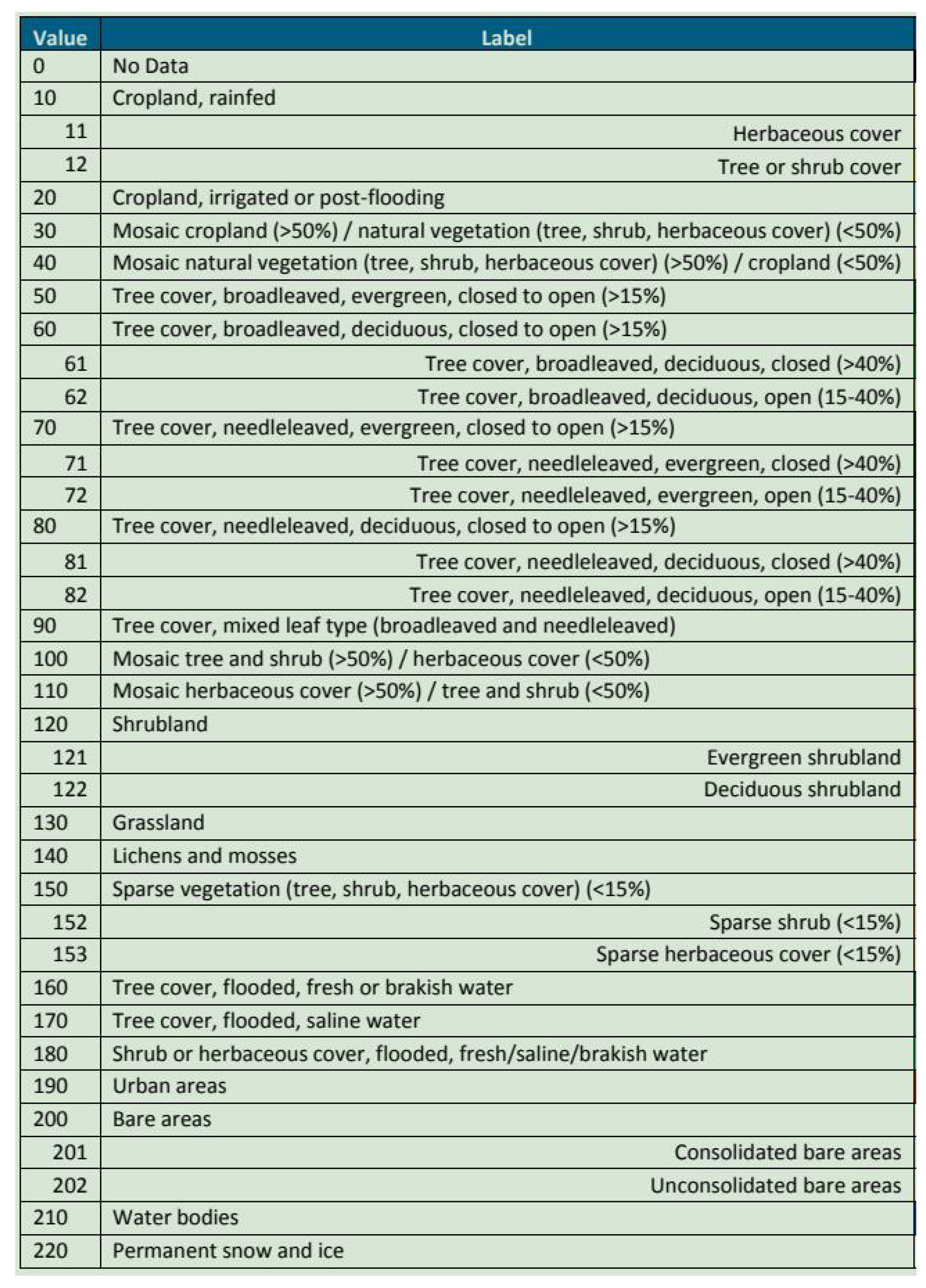
To unify the land use types for the analysis of land use change, the land use types in the Landuse dataset in China (1980–2015) and ESA were matched to the primary land use categories of Globaland30. This was necessary because the land use types in these datasets were not completely consistent. Merging similar land use types into a general primary category can reduce the complexity of classification. The 25 secondary land use categories in the Landuse dataset in China (1980–2015) were merged into 10 primary categories consistent with Globaland30, as shown in
Table 2. For example, high-coverage grass, medium-cover meadow, and low-cover grass were merged into the grassland category, while forest land, shrubland, sparse forest land, and other forest land were merged into the forest land category. The categories of land use products from three sources were aligned by merging categories, using rules similar to the specifications for studying the response of ecosystem services to land use changes [
50].
The 22 land use types in ESA were also merged into 10 land use categories consistent with Globaland30. For example, consolidated bare areas and unconsolidated bare areas were merged into the bare land category, and shrubland, evergreen shrubland, and deciduous shrubland were merged into the shrubland category. In a study of ecosystem services on Madagascar Island, Africa, ESA CCI land cover types were merged into eight categories [
50], which differs from this study, where the land categories include permanent snow and ice and lichens and mosses. Although the Turpan region has distributions of permanent snow and ice land types, it does not have lichens and mosses land types. The rules for reclassification are shown in
Table 3.
The reclassification of land cover was carried out using ArcGIS software. The Join and Relates tool was used to associate an Excel file containing the correspondence between secondary classifications and reclassified classifications based on the code field with a raster map of land use/land cover types. This allowed each pixel of the raster data to be assigned the attributes of a primary land class. The Raster to Polygon tool in ArcGIS 10.2 was then used to convert the land use types of the raster structure into a vector format. The Dissolve tool was used to merge different objects of the same reclassified land use category based on the Dissolve_Field(s) (optional) option. The attribute table of the vector layer generated by Dissolve provided the total area of the various land classes in the reclassified ground class.
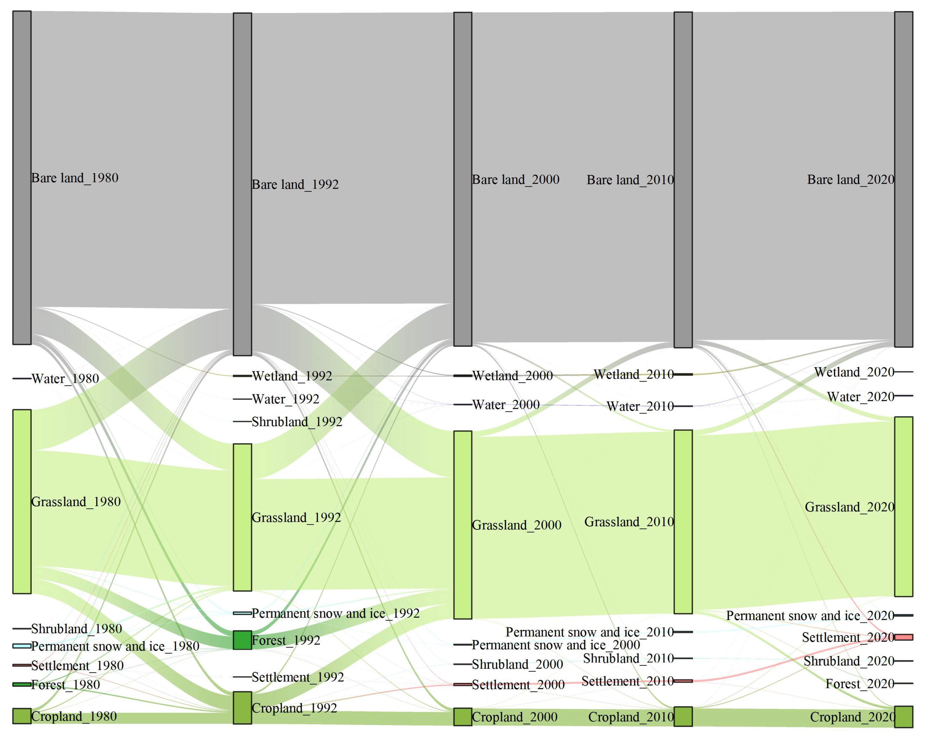
To obtain the land type transition map for different years, the Intersect tool was used to intersect vector layers of different years. The area field was added to the attribute table of the land use/land cover distribution vector map obtained by Intersect, and the area was calculated using the field calculator. The attribute table was then converted to Excel format, and a land use/land cover transfer matrix was created using the Excel pivot table function.
5. Discussion
The Turpan karez system is a traditional underground irrigation system in the Xinjiang region, which has been an important support for agricultural production in the area since ancient times. However, with the influence of climate change and human activities in recent years, the number and status of Turpan karezes have undergone significant changes, which have also affected local agricultural production. Based on historical remote sensing imagery data from CORONA and field investigations, it has been found that the number of Turpan karezes has significantly decreased over the past few decades. Some karezes have lost their irrigation function due to a long-term lack of maintenance and management and have become abandoned, while others are in varying degrees of damage and decay. These changes are mainly due to the influence of human activities, such as excessive groundwater exploitation, land use change, and urbanization, as well as the impact of climate change, such as increased extreme weather events.
The changes in Turpan karezes have had a significant impact on agricultural production in the region. Due to the lack of sufficient irrigation water sources, agricultural production has been severely limited, leading to problems such as decreased crop yield and land degradation. In addition, the decline of karezes has also brought adverse effects on local social and economic development, such as labor force loss and income reduction. Therefore, in order to protect the Turpan karezes and promote sustainable development in the region, a series of measures need to be taken, including strengthening the management and protection of groundwater resources, promoting water-saving irrigation technology, and improving land use planning and urbanization management.
The Turpan Karez Park offers a comprehensive display of the structure, culture, and history of the karez system, providing not only a place for the inheritance of karez culture but also cultural enrichment for tourism development. Karez systems are a testament to the wisdom of people living in arid areas to adapt to their environment and have served as the lifeline of oasis civilizations throughout history. Karez systems represent a sustainable way of using water resources and can serve as a reference for the construction of ecological civilization.
6. Conclusions
Turpan Karez Park presents a relatively complete display of the structure, culture, and history of karezes. It serves as a site for the preservation of karez culture and provides cultural significance for the development of tourism. Karez systems are the crystallization of the wisdom of the people of arid areas to adapt to the environment, and are the lifeline of oasis civilization in history. Karez systems are a sustainable way to use water resources and can provide a reference for the construction of ecological civilization. Studying the impact of land use/land cover change on karezes can provide a reference for karez protection and maintenance. The extraction of spatial distribution information of karezes can also provide a basis for the delineation of core areas and buffer zones for karez protection.
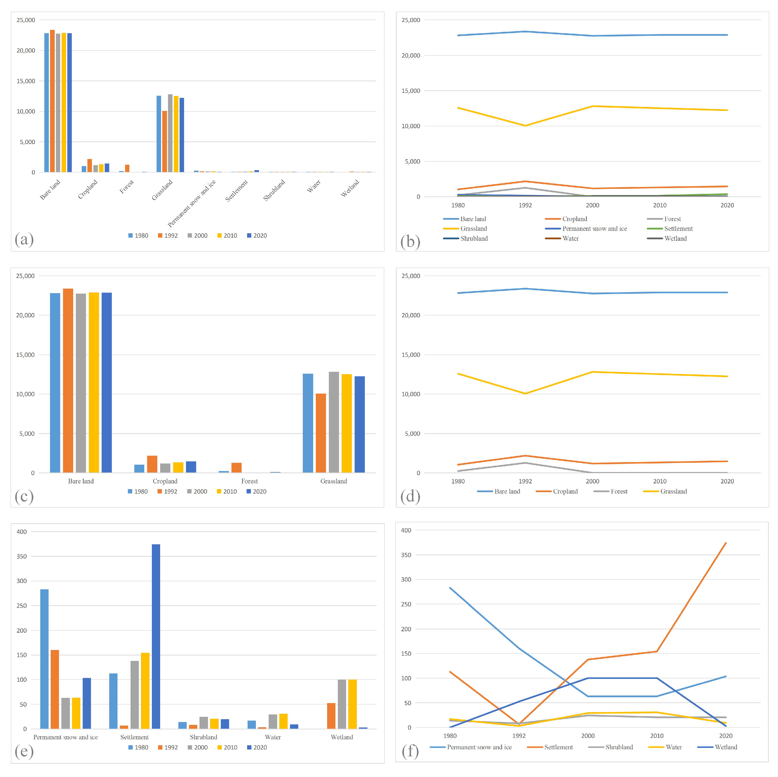
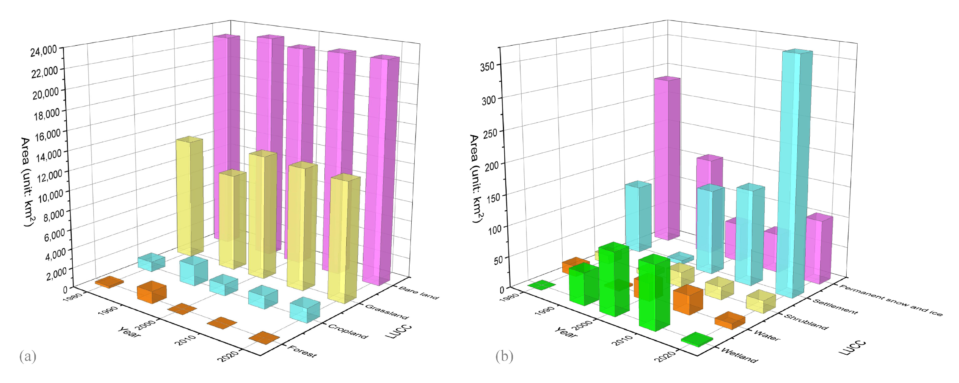
Remote sensing technology has the advantages of providing macroscopic, objective, and dynamic monitoring of the Earth’s surface. This study used historical CORONA images to visually interpret the karez system in the 1970s. By analyzing land use/land cover changes at different times, a land use/land cover transfer matrix and land transfer visualization were obtained. The results showed that from 1970 to 2020, as the population grew, the demand for arable land and built-up areas increased, resulting in an increase in arable land and built-up areas, while the water area decreased. With the advent of electromechanical well technology and the increase in the number of such wells, the maintenance and utilization of karezes have gradually decreased. In general, the increase in arable land and built-up areas, the decrease in water area, and the increase in the number of electromechanical wells have combined to reduce the number of karez systems. By comparing the CORONA image from 1970 with the karez shafts in 2020, it is possible to visualize the karezes that existed in 1970 but did not exist in 2020. Some karez shafts that existed on bare terrain areas in 1970 were truncated when the land use/land cover changed to arable land.
Overall, the Turpan karez system is a valuable cultural and ecological resource, and its protection and sustainable use are of great significance. The use of remote sensing technology and historical data has provided valuable insights into the changes in the Karez system and the impact of land use/land cover changes on the system in the Turpan Basin. These findings can provide valuable information for karez protection and maintenance. The spatial distribution information of karezes can also provide a basis for the delineation of core areas and buffer zones for karez protection, promoting sustainable development in the region.
