Monitoring Land Use/Land Cover and Landscape Pattern Changes at a Local Scale: A Case Study of Pyongyang, North Korea
Abstract
1. Introduction
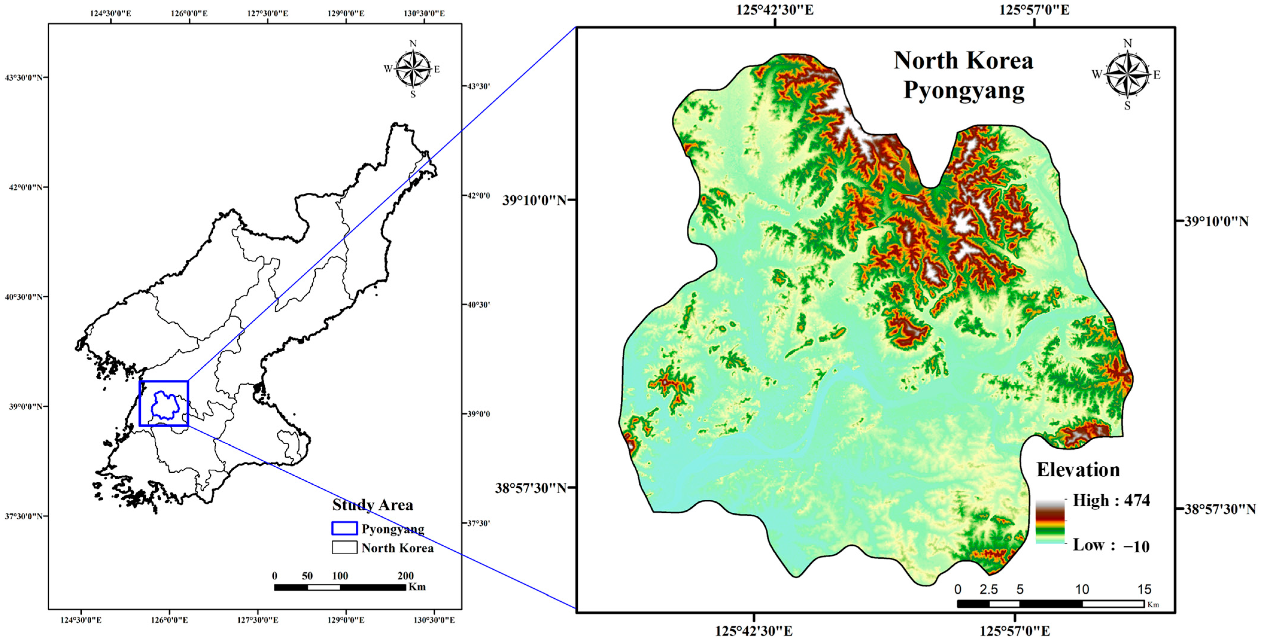
2. Study Area
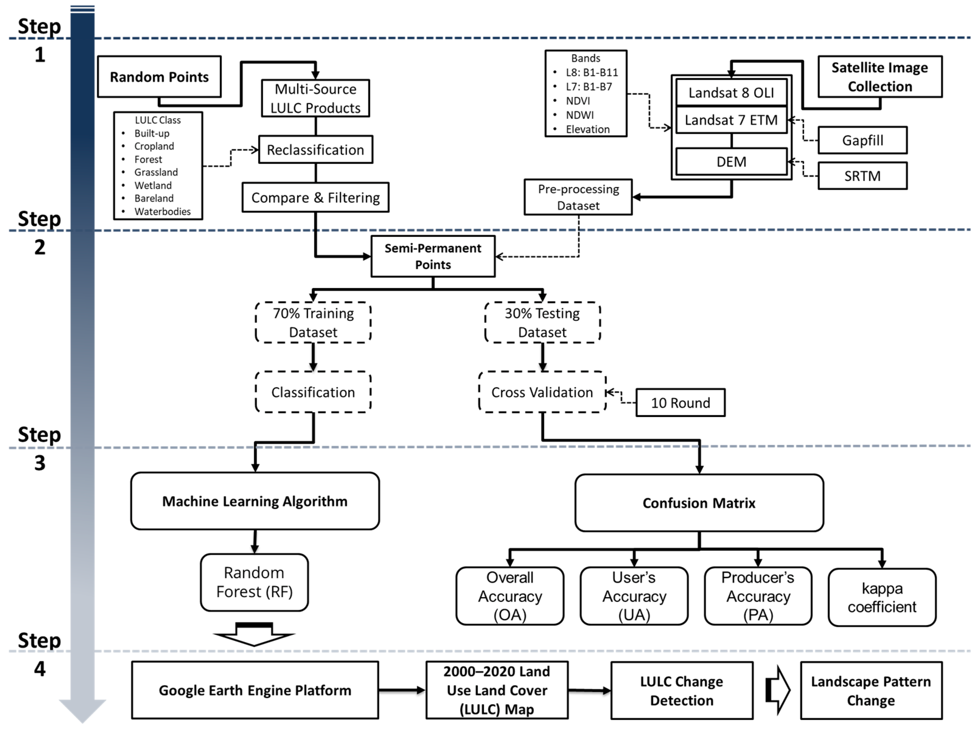
3. Materials and Methods
3.1. Data Collection
3.2. Data Processing
3.3. Machine-Learning Algorithm
3.4. LULC Change Detection
3.5. Landscape Metrics for Landscape Pattern Changes
4. Results
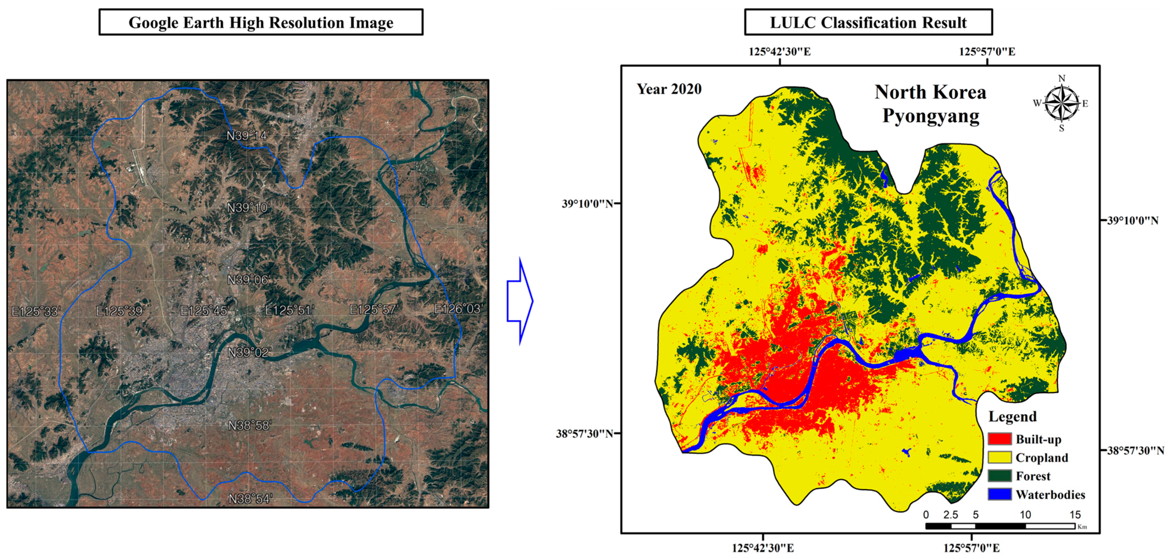
4.1. LULC Classification Results and Accuracy
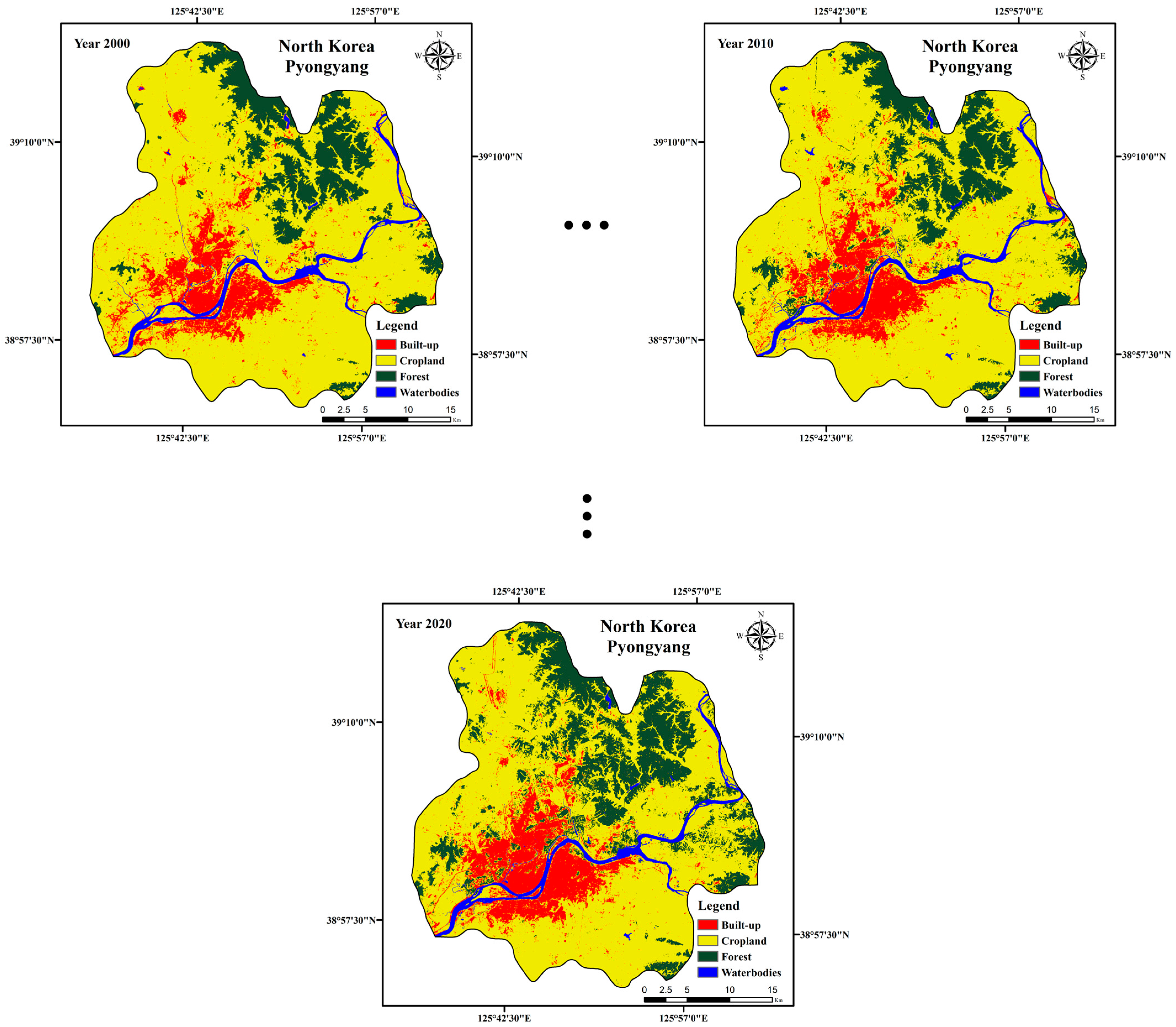
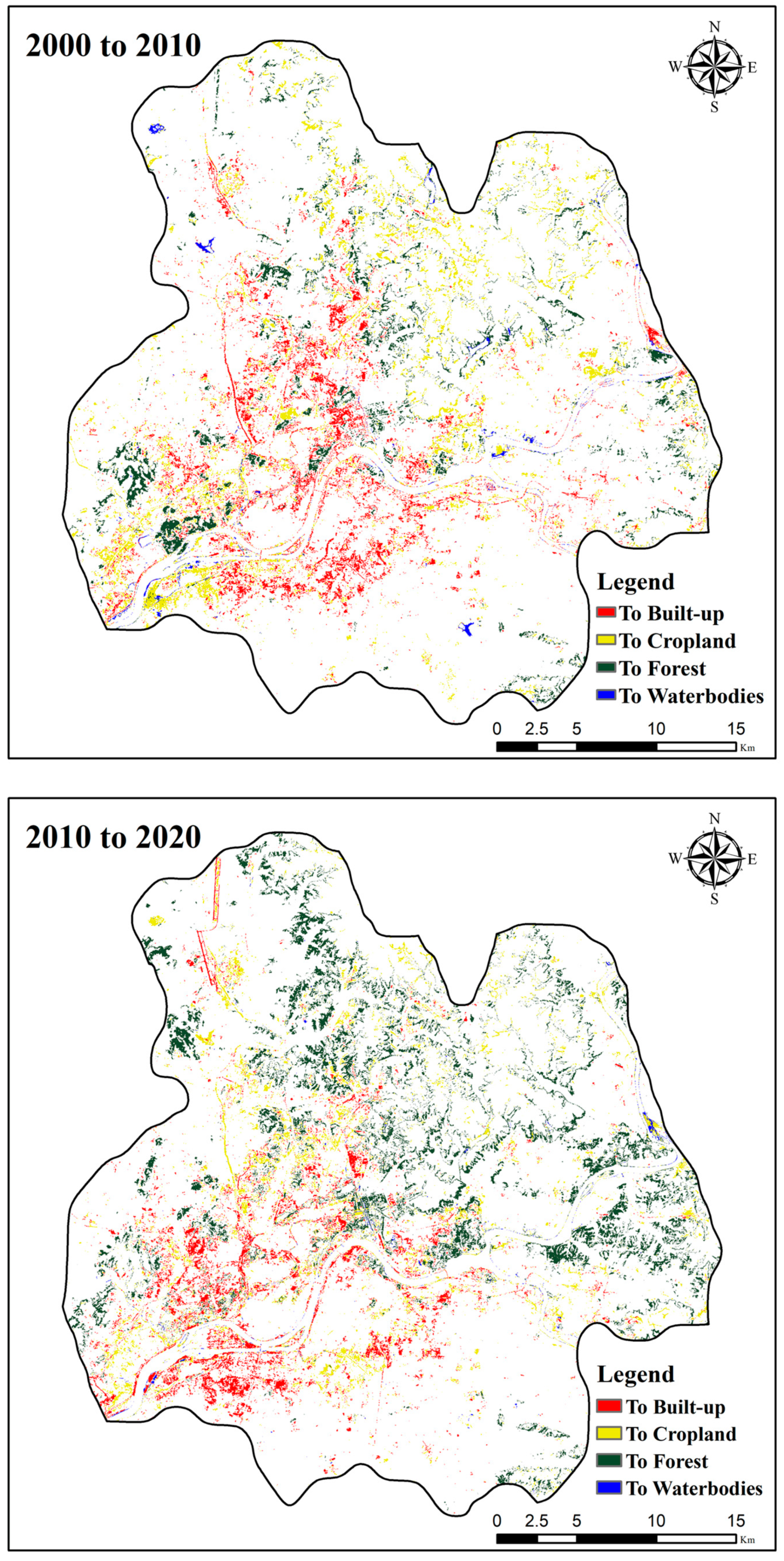
4.2. LULC Change-Detection Results
4.3. Landscape Pattern Change
5. Discussion
6. Conclusions
- The flat ground areas have been fully utilized, allowing for ample room for future development.
- The main urban area has been developed in a compact manner, which is beneficial in slowing down the trend of urban fragmentation.
- The expansion of the main urban area has resulted in the conversion of surrounding cropland into built-up areas, and making full use of the landscape resources of the Taedong River.
Author Contributions
Funding
Data Availability Statement
Acknowledgments
Conflicts of Interest
References
- Lambin, E.F.; Turner, B.L.; Geist, H.J.; Agbola, S.B.; Angelsen, A.; Bruce, J.W.; Coomes, O.T.; Dirzo, R.; Fischer, G.; Folke, C.; et al. The causes of land-use and land-cover change: Moving beyond the myths. Glob. Environ. Change 2001, 11, 261–269. [Google Scholar] [CrossRef]
- Vitousek, P.M.; Mooney, H.A.; Lubchenco, J.; Melillo, J.M. Human domination of Earth’s ecosystems. Science 1997, 277, 494–499. [Google Scholar] [CrossRef]
- Braimoh, A.K. Random and systematic land-cover transitions in northern Ghana. Agric. Ecosyst. Environ. 2006, 113, 254–263. [Google Scholar] [CrossRef]
- Yang, X.; Zheng, X.-Q.; Chen, R. A land use change model: Integrating landscape pattern indexes and Markov-CA. Ecol. Modell. 2014, 283, 1–7. [Google Scholar] [CrossRef]
- Su, S.; Ma, X.; Xiao, R. Agricultural landscape pattern changes in response to urbanization at ecoregional scale. Ecol. Indic. 2014, 40, 10–18. [Google Scholar] [CrossRef]
- Zhao, Z.; Sharifi, A.; Dong, X.; Shen, L.; He, B.-J. Spatial variability and temporal heterogeneity of surface urban heat island patterns and the suitability of local climate zones for land surface temperature characterization. Remote Sens. 2021, 13, 4338. [Google Scholar] [CrossRef]
- Li, H.; Peng, J.; Yanxu, L.; Yi’na, H. Urbanization impact on landscape patterns in Beijing City, China: A spatial heterogeneity perspective. Ecol. Indic. 2017, 82, 50–60. [Google Scholar] [CrossRef]
- He, B.-J.; Zhao, Z.-Q.; Shen, L.-D.; Wang, H.-B.; Li, L.-G. An approach to examining performances of cool/hot sources in mitigating/enhancing land surface temperature under different temperature backgrounds based on landsat 8 image. Sustain. Cities Soc. 2019, 44, 416–427. [Google Scholar] [CrossRef]
- Zhang, H.; Qi, Z.-F.; Ye, X.-Y.; Cai, Y.-B.; Ma, W.-C.; Chen, M.-N. Analysis of land use/land cover change, population shift, and their effects on spatiotemporal patterns of urban heat islands in metropolitan Shanghai, China. Appl. Geogr. 2013, 44, 121–133. [Google Scholar] [CrossRef]
- Zhao, Z.-Q.; He, B.-J.; Li, L.-G.; Wang, H.-B.; Darko, A. Profile and concentric zonal analysis of relationships between land use/land cover and land surface temperature: Case study of Shenyang, China. Energy Build. 2017, 155, 282–295. [Google Scholar] [CrossRef]
- Hassan, T.; Zhang, J.; Prodhan, F.A.; Pangali Sharma, T.P.; Bashir, B. Surface urban heat islands dynamics in response to LULC and vegetation across South Asia (2000–2019). Remote Sens. 2021, 13, 3177. [Google Scholar] [CrossRef]
- Kandel, H.; Melesse, A.; Whitman, D. An analysis on the urban heat island effect using radiosonde profiles and Landsat imagery with ground meteorological data in South Florida. Int. J. Remote Sens. 2016, 37, 2313–2337. [Google Scholar] [CrossRef]
- Dadashpoor, H.; Azizi, P.; Moghadasi, M. Land use change, urbanization, and change in landscape pattern in a metropolitan area. Sci. Total Environ. 2019, 655, 707–719. [Google Scholar] [CrossRef]
- Deng, J.S.; Wang, K.; Hong, Y.; Qi, J.G. Spatio-temporal dynamics and evolution of land use change and landscape pattern in response to rapid urbanization. Landsc. Urban Plan. 2009, 92, 187–198. [Google Scholar] [CrossRef]
- Weng, Y.-C. Spatiotemporal changes of landscape pattern in response to urbanization. Landsc. Urban Plan. 2007, 81, 341–353. [Google Scholar] [CrossRef]
- Kamusoko, C.; Aniya, M. Land use/cover change and landscape fragmentation analysis in the Bindura District, Zimbabwe. Land Degrad. Dev. 2007, 18, 221–233. [Google Scholar] [CrossRef]
- Fan, Q.; Ding, S. Landscape pattern changes at a county scale: A case study in Fengqiu, Henan Province, China from 1990 to 2013. CATENA 2016, 137, 152–160. [Google Scholar] [CrossRef]
- Gorelick, N.; Hancher, M.; Dixon, M.; Ilyushchenko, S.; Thau, D.; Moore, R. Google Earth Engine: Planetary-scale geospatial analysis for everyone. Remote Sens. Environ. 2017, 202, 18–27. [Google Scholar] [CrossRef]
- Hu, Y.; Hu, Y. Land cover changes and their driving mechanisms in Central Asia from 2001 to 2017 supported by Google earth engine. Remote Sens. 2019, 11, 554. [Google Scholar] [CrossRef]
- Hu, Y.; Hu, Y. Detecting forest disturbance and recovery in Primorsky Krai, Russia, using annual Landsat time series and multi–source land cover products. Remote Sens. 2020, 12, 129. [Google Scholar] [CrossRef]
- Qu, L.a.; Chen, Z.; Li, M.; Zhi, J.; Wang, H. Accuracy improvements to pixel-based and object-based lulc classification with auxiliary datasets from Google Earth engine. Remote Sens. 2021, 13, 453. [Google Scholar] [CrossRef]
- McGarigal, K.; Cushman, S.A.; Neel, M.C.; Ene, E. FRAGSTATS: Spatial Pattern Analysis Program for Categorical Maps. Computer Software Program Produced by the Authors at the University of Massachusetts—Amherst. 2002, 6. Available online: www.umass.edu/landeco/research/fragstats/fragstats.html (accessed on 17 September 2022).
- Piao, Y.; Jeong, S.; Park, S.; Lee, D. Analysis of land use and land cover change using time-series data and random forest in North Korea. Remote Sens. 2021, 13, 3501. [Google Scholar] [CrossRef]
- Herold, M.; Couclelis, H.; Clarke, K.C. The role of spatial metrics in the analysis and modeling of urban land use change. Comput. Environ. Urban Syst. 2005, 29, 369–399. [Google Scholar] [CrossRef]
- Engler, R.; Teplyakov, V.; Adams, J.M. An assessment of forest cover trends in South and North Korea, from 1980 to 2010. Environ. Manag. 2014, 53, 194–201. [Google Scholar] [CrossRef]
- Choi, W.; Kang, S.; Choi, J.; Larsen, J.J.; Oh, C.; Na, Y.-G. Characteristics of deforestation in the Democratic People’s Republic of Korea (North Korea) between the 1980s and 2000s. Reg. Environ. Change 2017, 17, 379–388. [Google Scholar] [CrossRef]
- Yu, J.; Park, H.; Lee, S.-H.; Kim, K. Review of slope criteria and forestland restoration plan in North Korea. J. Korea Soc. Environ. Restor. Technol. 2016, 19, 19–28. [Google Scholar] [CrossRef]
- Park, K.; Lee, S.; Park, S. A study on the North Korea’s change of forest policy since the economic crisis in 1990s. Korean J. Unification Aff. 2009, 21, 459–492. [Google Scholar]
- Lim, C.-H.; Choi, Y.; Kim, M.; Jeon, S.W.; Lee, W.-K. Impact of deforestation on agro-environmental variables in cropland, North Korea. Sustainability 2017, 9, 1354. [Google Scholar] [CrossRef]
- Farr, T.G.; Rosen, P.A.; Caro, E.; Crippen, R.; Duren, R.; Hensley, S.; Kobrick, M.; Paller, M.; Rodriguez, E.; Roth, L.; et al. The shuttle radar topography mission. Rev. Geophys. 2007, 45. [Google Scholar] [CrossRef]
- DeFries, R.S.; Townshend, J.R.G. NDVI-derived land cover classifications at a global scale. Int. J. Remote Sens. 1994, 15, 3567–3586. [Google Scholar] [CrossRef]
- McFeeters, S.K. The use of the Normalized Difference Water Index (NDWI) in the delineation of open water features. Int. J. Remote Sens. 1996, 17, 1425–1432. [Google Scholar] [CrossRef]
- Sulla-Menashe, D.; Friedl, M.A. User Guide to Collection 6 MODIS Land Cover (MCD12Q1 and MCD12C1) Product; United States Geological Survey: Reston, VA, USA, 2018; Volume 1, p. 18. [Google Scholar]
- Masiliūnas, D.; Tsendbazar, N.-E.; Herold, M.; Lesiv, M.; Buchhorn, M.; Verbesselt, J. Global land characterisation using land cover fractions at 100 m resolution. Remote Sens. Environ. 2021, 259, 112409. [Google Scholar] [CrossRef]
- Li, C.; Gong, P.; Wang, J.; Zhu, Z.; Biging, G.S.; Yuan, C.; Hu, T.; Zhang, H.; Wang, Q.; Li, X.; et al. The first all-season sample set for mapping global land cover with Landsat-8 data. Sci. Bull. 2017, 62, 508–515. [Google Scholar] [CrossRef]
- Gong, P.; Wang, J.; Yu, L.; Zhao, Y.; Zhao, Y.; Liang, L.; Niu, Z.; Huang, X.; Fu, H.; Liu, S.; et al. Finer resolution observation and monitoring of global land cover: First mapping results with Landsat TM and ETM+ data. Int. J. Remote Sens. 2013, 34, 2607–2654. [Google Scholar] [CrossRef]
- Chen, J.; Chen, J.; Liao, A.; Cao, X.; Chen, L.; Chen, X.; He, C.; Han, G.; Peng, S.; Lu, M.; et al. Global land cover mapping at 30m resolution: A POK-based operational approach. ISPRS J. Photogramm. 2015, 103, 7–27. [Google Scholar] [CrossRef]
- Hansen, M.C.; Potapov, P.V.; Moore, R.; Hancher, M.; Turubanova, S.A.; Tyukavina, A.; Thau, D.; Stehman, S.V.; Goetz, S.J.; Loveland, T.R.; et al. High-resolution global maps of 21st-century forest cover change. Science 2013, 342, 850–853. [Google Scholar] [CrossRef]
- Oliphant, A.J.; Thenkabail, P.S.; Teluguntla, P.; Xiong, J.; Gumma, M.K.; Congalton, R.G.; Yadav, K. Mapping cropland extent of Southeast and NorthEast Asia using multi-year time-series Landsat 30-m data using a random forest classifier on the Google Earth Engine Cloud. Int. J. Appl. Earth Obs. Geoinf. 2019, 81, 110–124. [Google Scholar] [CrossRef]
- Jin, Y.; Sung, S.; Lee, D.K.; Biging, G.S.; Jeong, S. Mapping deforestation in North Korea using phenology-based multi-index and random forest. Remote Sens. 2016, 8, 997. [Google Scholar] [CrossRef]
- Chander, G.; Markham, B.L.; Helder, D.L. Summary of current radiometric calibration coefficients for Landsat MSS, TM, ETM+, and EO-1 ALI sensors. Remote Sens. Environ. 2009, 113, 893–903. [Google Scholar] [CrossRef]
- Yin, G.; Mariethoz, G.; Sun, Y.; McCabe, M.F. A comparison of gap-filling approaches for Landsat-7 satellite data. Int. J. Remote Sens. 2017, 38, 6653–6679. [Google Scholar] [CrossRef]
- Inglada, J.; Vincent, A.; Arias, M.; Tardy, B.; Morin, D.; Rodes, I. Operational high resolution land cover map production at the country scale using satellite image time series. Remote Sens. 2017, 9, 95. [Google Scholar] [CrossRef]
- Foody, G.M.; Mathur, A. Toward intelligent training of supervised image classifications: Directing training data acquisition for SVM classification. Remote Sens. Environ. 2004, 93, 107–117. [Google Scholar] [CrossRef]
- Talukdar, S.; Singha, P.; Mahato, S.; Shahfahad; Pal, S.; Liou, Y.; Rahman, A. Land-use land-cover classification by machine learning classifiers for satellite observations—A review. Remote Sens. 2020, 12, 1135. [Google Scholar] [CrossRef]
- Breiman, L. Random forests. Mach. Learn. 2001, 45, 5–32. [Google Scholar] [CrossRef]
- Naghibi, S.A.; Pourghasemi, H.R.; Dixon, B. GIS-based groundwater potential mapping using boosted regression tree, classification and regression tree, and random forest machine learning models in Iran. Environ. Monit. Assess. 2016, 188, 44. [Google Scholar] [CrossRef]
- Tamiminia, H.; Salehi, B.; Mahdianpari, M.; Quackenbush, L.; Adeli, S.; Brisco, B. Google Earth Engine for geo-big data applications: A meta-analysis and systematic review. ISPRS J. Photogramm. 2020, 164, 152–170. [Google Scholar] [CrossRef]
- Rodriguez-Galiano, V.F.; Ghimire, B.; Rogan, J.; Chica-Olmo, M.; Rigol-Sanchez, J.P. An assessment of the effectiveness of a random forest classifier for land-cover classification. ISPRS J. Photogramm. 2012, 67, 93–104. [Google Scholar] [CrossRef]
- Abdullah, A.Y.M.; Masrur, A.; Adnan, M.S.G.; Baky, M.A.A.; Hassan, Q.K.; Dewan, A. Spatio-temporal patterns of land use/land cover change in the heterogeneous coastal region of Bangladesh between 1990 and 2017. Remote Sens. 2019, 11, 790. [Google Scholar] [CrossRef]
- Křováková, K.; Semerádová, S.; Mudrochová, M.; Skaloš, J. Landscape functions and their change—A review on methodological approaches. Ecol. Eng. 2015, 75, 378–383. [Google Scholar] [CrossRef]
- Anderson, J.R. A Land Use and Land Cover Classification System for Use with Remote Sensor Data; Government Printing Office: Washington, DC, USA, 1976; Volume 964. [Google Scholar]
- Statistics Korea. Major Statistical Indicators of North Korea; Major Statistical Indicators of North Korea: Seoul, Republic of Korea, 2020. (In Korean) [Google Scholar]
- Lee, S. North Korean Industrial Statistics; KIET: Sejong, Republic of Korea, 2015. [Google Scholar]
- Oh, S.; Kim, E.; Kim, K. Characteristics of forest policy in the Kim Jong-Un era. North Korean Stud. 2018, 14, 101–133. [Google Scholar]
- National Institute of Forest Science. Development of a Method of Constructing North Korean Forest Information Using Satellite Imagery and AI; National Institute of Forest Science: Seoul, Republic of Korea, 2020. (In Korean) [Google Scholar]

| Type | Data Collection | Used Temporal Coverage | Term | Spatial Resolution | Reference |
|---|---|---|---|---|---|
| Satellite Product | Landsat 7 ETM + Collection 2 Level 1 top-of-atmosphere reflectance (TOA) | 2000–2012 | 16 days | 30 m | (usgs.gov, accessed on 1 September 2022) |
| Landsat 8 OLI Collection 2 Level 1 top-of-atmosphere reflectance (TOA) | 2013–2020 | 16 days | 30 m | (usgs.gov, accessed on 1 September 2022) | |
| Shuttle Radar Topography Mission V3 product (SRTM3) | 2000 | - | 30 m | Farr et al. [30] | |
| LULC Product | MCD12Q1.006 | 2001–2020 | 1 year | 500 m | Sulla-Menashe & Friedl et al. [33] |
| COPERNICUS | 2015–2019 | 1 year | 100 m | Masiliūnas et al. [34] | |
| South Korea’s Ministry of Environment (MoE) LULC Map | 2000, 2010 | - | 30 m | (egis.me.go.kr, accessed on 1 September 2022) | |
| Finer Resolution Observation and Monitoring of Global Land Cover (FROM-GLC) | 2015, 2017 | - | 30 m | Li et al. [35] Gong et al. [36] | |
| GlobeLand30 (GLC30) | 2000, 2010, 2020 | - | 30 m | Chen et al. [37] | |
| Global Forest Change dataset (GFCD) | 2000 | - | 30 m | Hansen et al. [38] | |
| Global Food Security-support Analysis Data Extent Southeast and Northeast Asia (GFSAD30SEACE) | 2015 | - | 30 m | Oliphant et al. [39] |
| Landscape Metrics | Abbreviation | Description | Range | Local Level | Class Level |
|---|---|---|---|---|---|
| Number of patches | NP | The number of patches | O | O | |
| Patch density | PD | The aggregation of different LULC types in the landscape | O | ||
| Largest patch index | LPI | The percentage of landscape covered by the corresponding largest patch for LULC class type | O | O | |
| Landscape shape index | LSI | The ratio between the actual landscape edge length and the assumed minimum edge length | O | ||
| Percentage of landscape of class | PLAND | The proportion of total area occupied by the LULC class type | O | ||
| Shannon’s evenness index | SHEI | A measure of patch diversity, determined by the proportional distribution of different LULC types in the landscape | O | ||
| Perimeter area fractal dimension | PAFRAC | A measure of shape, determined by the patch complexity of LULC class type in landscapes | O |
| Land Cover | User Accuracy | Producer Accuracy |
|---|---|---|
| Built-up | 96.56 ± 3.44% | 92.06 ± 3.89% |
| Cropland | 98.29 ± 1.71% | 99.05 ± 0.95% |
| Forest | 99.30 ± 0.70% | 98.55 ± 1.45% |
| Waterbodies | 100 ± 0% | 98.21 ± 1.79% |
| Overall Accuracy | 97.66 ± 1.36% | Kappa Coefficient 0.95 ± 0.03 |
| Land Cover | Built-Up | Cropland | Forest | Waterbodies | |
|---|---|---|---|---|---|
| 2000 to 2010 | Built-up | 8.26% | 2.13% | 0.02% | 0.09% |
| Cropland | 3.33% | 66.68% | 2.78% | 0.20% | |
| Forest | 0.00% | 1.32% | 11.96% | 0.00% | |
| Waterbodies | 0.09% | 0.06% | 0.00% | 3.08% | |
| Total (%) | 100% | ||||
| 2010 to 2020 | Built-up | 9.49% | 2.06% | 0.05% | 0.08% |
| Cropland | 2.93% | 61.31% | 5.87% | 0.07% | |
| Forest | 0.02% | 0.56% | 14.17% | 0.01% | |
| Waterbodies | 0.06% | 0.19% | 0.02% | 3.10% | |
| Total (%) | 100% | ||||
| Local Level | Landscape Metrics | |||
|---|---|---|---|---|
| Year | NP | LPI | LSI | SHEI |
| 2000 | 9304 | 18.53% | 22.85 | 0.61 |
| 2010 | 11,559 | 17.88% | 27.65 | 0.65 |
| 2020 | 16,538 | 15.33% | 34.84 | 0.71 |
| Class Level | Class Metrics | |||||
|---|---|---|---|---|---|---|
| Year | Class | NP | PD | LPI | PLAND | PAFRAC |
| 2000 | Built-up | 5167 | 1.87% | 1.72% | 4.45% | 1.32 |
| 2010 | Built-up | 5829 | 2.11% | 3.19% | 4.96% | 1.34 |
| 2020 | Built-up | 5768 | 2.08% | 4.07% | 5.31% | 1.26 |
| 2000 | Cropland | 2450 | 0.89% | 18.53% | 30.99% | 1.28 |
| 2010 | Cropland | 2743 | 0.99% | 17.88% | 29.80% | 1.32 |
| 2020 | Cropland | 5768 | 2.08% | 15.33% | 27.22% | 1.32 |
| 2000 | Forest | 1324 | 0.48% | 1.87% | 5.64% | 1.27 |
| 2010 | Forest | 2641 | 0.95% | 2.53% | 6.27% | 1.30 |
| 2020 | Forest | 4464 | 1.61% | 1.74% | 8.54% | 1.32 |
| 2000 | Waterbodies | 363 | 0.13% | 1.22% | 1.37% | 1.37 |
| 2010 | Waterbodies | 346 | 0.13% | 0.71% | 1.43% | 1.38 |
| 2020 | Waterbodies | 538 | 0.19% | 0.62% | 1.39% | 1.32 |
Disclaimer/Publisher’s Note: The statements, opinions and data contained in all publications are solely those of the individual author(s) and contributor(s) and not of MDPI and/or the editor(s). MDPI and/or the editor(s) disclaim responsibility for any injury to people or property resulting from any ideas, methods, instructions or products referred to in the content. |
© 2023 by the authors. Licensee MDPI, Basel, Switzerland. This article is an open access article distributed under the terms and conditions of the Creative Commons Attribution (CC BY) license (https://creativecommons.org/licenses/by/4.0/).
Share and Cite
Piao, Y.; Xiao, Y.; Ma, F.; Park, S.; Lee, D.; Mo, Y.; Jeong, S.; Hwang, I.; Kim, Y. Monitoring Land Use/Land Cover and Landscape Pattern Changes at a Local Scale: A Case Study of Pyongyang, North Korea. Remote Sens. 2023, 15, 1592. https://doi.org/10.3390/rs15061592
Piao Y, Xiao Y, Ma F, Park S, Lee D, Mo Y, Jeong S, Hwang I, Kim Y. Monitoring Land Use/Land Cover and Landscape Pattern Changes at a Local Scale: A Case Study of Pyongyang, North Korea. Remote Sensing. 2023; 15(6):1592. https://doi.org/10.3390/rs15061592
Chicago/Turabian StylePiao, Yong, Yi Xiao, Fengdi Ma, Sangjin Park, Dongkun Lee, Yongwon Mo, Seunggyu Jeong, Injae Hwang, and Yujin Kim. 2023. "Monitoring Land Use/Land Cover and Landscape Pattern Changes at a Local Scale: A Case Study of Pyongyang, North Korea" Remote Sensing 15, no. 6: 1592. https://doi.org/10.3390/rs15061592
APA StylePiao, Y., Xiao, Y., Ma, F., Park, S., Lee, D., Mo, Y., Jeong, S., Hwang, I., & Kim, Y. (2023). Monitoring Land Use/Land Cover and Landscape Pattern Changes at a Local Scale: A Case Study of Pyongyang, North Korea. Remote Sensing, 15(6), 1592. https://doi.org/10.3390/rs15061592


