Article

Changes in Sea Surface Temperature and Sea Ice Concentration in the Arctic Ocean over the Past Two Decades

1
School of Earth Resources, China University of Geosciences, Wuhan 430074, China
2
International Research Center of Big Data for Sustainable Development Goals, Beijing 100049, China
3
Key Laboratory of Digital Earth Science, Aerospace Information Research Institute, Chinese Academy of Sciences, Beijing 100049, China
4
University of Chinese Academy of Sciences, Beijing 100049, China
5
Finnish Meteorological Institute, FI00101 Helsinki, Finland
*
Author to whom correspondence should be addressed.
Remote Sens. 2023, 15(4), 1095; https://doi.org/10.3390/rs15041095
Submission received: 21 December 2022 / Revised: 14 February 2023 / Accepted: 15 February 2023 / Published: 17 February 2023
(This article belongs to the Special Issue Remote Sensing Monitoring for Arctic Region)

Abstract

:
With global warming, the decrease in sea ice creates favorable conditions for Arctic activities. Sea surface temperature (SST) is not only an important driven factor of sea ice concentration (SIC) changes but also an important medium of the ocean–atmosphere interaction. However, the response of sea surface temperature to Arctic sea ice varies in different sea areas. Using the optimal interpolated SST data from the National Centers for Environmental Information (NCEI) and SIC data from the University of Bremen, the temporal and spatial characteristics of SST and SIC in the Arctic above 60°N and their relationship are studied, and the melting and freezing time of sea ice are calculated, which is particularly important for the prediction of Arctic shipping and sea ice. The results show that (1) the highest and lowest monthly mean Arctic SST occur in August and March, respectively, while those of SIC are in March and September. The maximum trends of SST and SIC changes are in autumn, which are +0.01 °C/year and −0.45%/year, respectively. (2) There is a significant negative correlation between the Arctic SST and SIC with a correlation coefficient of −0.82. (3) The sea ice break-up occurs on Day of the Year (DoY) 143 and freeze-up occurs on DoY 296 in the Arctic. The melting and freezing processes lasted for 27 days and 14 days, respectively. (4) The Kara Sea showed the strongest trend of sea ice melting at −1.22 d/year, followed by the Laptev Sea at −1.17 d/year. The delay trend of sea ice freezing was the most significant in the Kara Sea +1.75 d/year, followed by the Laptev Sea +1.70 d/year. In the Arctic, the trend toward earlier melting of sea ice is smaller than the trend toward later freezing.

1. Introduction

In recent decades, the temperature in the near-surface Arctic has warmed twice as fast as the global average [1,2,3]. This Arctic amplification phenomenon intensifies the melting of Arctic sea ice and has a great impact on global climate change. SST is a key factor affecting the melting of sea ice. In the early stage, SST was monitored by ships, measuring the sea temperature from tens of centimeters to below 5 m [4]. Later, through the calculation and analysis of buoy and satellite data, the temperature at each depth was obtained according to different sensors and methods. As a major ocean variable, SST affects the exchange of energy, momentum, and gas between the ocean and the atmosphere. As an important part of the climate system, SST is often used as a key input parameter in numerical weather prediction and ocean prediction systems [5,6,7], which is also of great significance in revealing climate change [8].
One of the major oceanic characteristics of the ocean includes its ability to move large amounts of heat, fresh water, carbon, and other properties over long distances, affecting the ocean and the Earth’s climate, locally to globally, and always at scale [9]. Global SST has been increasing at a rate of approximately 0.016 °C per year from 1993 to 2020. This equates to an increase of approximately 0.43 °C worldwide. Compared with low-latitude regions, the long-wave radiation temperature in high-latitude regions is enhanced, which strengthens the heat exchange between the atmosphere and the ocean, and the huge heat transfer accelerates the rise of SST. In the past 140 years, global SST has increased at a rate of 0.0038 °C/a [10]. The annual average SST of the Arctic Ocean during the period of 1982–2018 was 1.32 ± 1.5 °C, and the overall warming trend was approximately 0.036 ± 0.03 °C/year. The annual mean temperature in the Barents Sea ranges from 0.2 °C to 3 °C, with a wide variation trend of −0.01 °C to 0.05 °C/year. The variation range in the Greenland Sea is larger, at −0.03 °C/year to 0.02 °C/year. The Norwegian Sea has a warming trend of 0.04–0.07 °C/year, while other marginal seas show a relatively weak warming trend of −0.01–0.01 ℃/year [11]. Influenced by latitude, seasonal regulation, and the nature of ocean currents, SST variation has obvious regional characteristics [12]. The variation of SST in different sea areas is not uniform.
The melting of ice in the Arctic may influence global climate, alter ecosystems, and create hazards, posing major challenges to nature and human activities [13]. The current sea-ice loss is driven by both atmospheric and oceanic processes [14]. Sea ice melting starts from the surface receiving atmospheric and solar heat fluxes, and solar radiation and ocean heat fluxes act together [15]. Seawater temperature is an important parameter in the estimation of ocean heat fluxes. In November 2018, the SIC and SST time series changes observed by satellite showed that the unusually warm SST in the Chukchi Sea delayed sea ice freezing, and the warm water prevented the advance of sea ice growth before the ocean heat was fully released into the atmosphere [16]. With the decrease in Arctic sea ice, the development of Arctic shipping ushered in opportunities. During 1978–2017, SST in the Northwest Passage showed an upward trend, and there was a significant negative correlation between SST and SIC. The correlation coefficient of SST and SIC in the northern Northwest Passage was as high as −0.96 [17]. Among the three Arctic shipping routes, the Northeast Shipping Route has the best navigable conditions [18,19,20,21] and is one of the important regions for energy exchange between land and sea in the Arctic region. Sea ice, the biggest obstacle to shipping in the Arctic, is also influenced by climatic factors such as storms, cyclones, and frontal activity [22,23,24]. From 1979 to 2018, the extent of sea ice in the Barents Sea and the Kara Sea showed downward trends of −23 ± 2.5% decade−1 and −7.3 ± 0.9% decade−1, respectively. The extent of sea ice in the Barents Sea in winter decreased more than that in the Kara Sea, while in summer, the sea ice cover in the Barents Sea has a downward trend of −4.1 ± 0.7 × 10³ km2yr−1 due to the influx of the warm Atlantic current. At the interannual scale, the Barents Sea–Kara Sea SST is negatively correlated with SIC. In winter, SST is negatively correlated with SIC in the Barents Sea compared with the Kara Sea, which is correlated with heat loss from the ocean to the atmosphere. In summer, SST in the Barents Sea shows no significant negative correlation with SIC [25]. With the increase in the Arctic temperature, SST has attracted more attention. SST is an important medium of the atmosphere–ice–ocean interaction. Correlation analysis of SST and SIC can promote the understanding of the differences among different Arctic Sea areas.
SST and sea ice in the Arctic are changing rapidly. Significant temperature increases and sea ice loss are critical to environmental change in the Arctic and also affect Arctic shipping [26], and the melting and freezing of sea ice are closely related to this. Between 2011 and 2020, Arctic sea-ice thickness was 1.87 ± 0.10 m at the start of the melting season in May and 0.82 ± 0.11 m by the end of the melting season in August. The critical melt period is from May to September [27]. With the loss of sea ice, the Arctic melting season has been significantly prolonged, showing an earlier start time of melting and a later start time of freezing. Based on the satellite time series analysis from 1979 to 2018, the date of autumn sea ice freezing is significantly correlated with the extent of sea ice in early summer. Sea ice loss is the main reason for the delay of autumn freezing, which is accompanied by the decrease in the surface albedo in summer, the increase in net shortwave radiation, and the increase in skin temperature [28]. The melting process of perennial Arctic sea ice is different from that of seasonal sea ice, and it is transforming into seasonal ice cover [29,30]. The perennial ice is usually near the North Pole, and the snow on its surface melts, forming large lakes, which carry heat and freshwater with the drainage, permeate along the flaws of the ice, and remain as melt ponds. Freshwater basal melt and solar warming of the ocean are ongoing, causing the SIC to slowly decline and basal melt to start, leaving the sea ice to persist throughout the summer. Seasonal sea ice generally forms at the edge of the Arctic. Under the influence of freshwater basal melt and solar warming of the ocean, the SIC decreased rapidly with snow remaining on the ice surface and basal melting. As the snow melts, small melt ponds form, the melt ponds drain to bring heat and fresh water to the sea ice, and the melt ponds become smaller until the ice melts completely and forms the open sea [31]. The area of rapid sea ice change is primarily in the thin ice area. The growth and melting of sea ice are affected by many factors, and Arctic sea ice is dynamic. It is very important for the Arctic climate system to determine the melting and freezing time of sea ice, especially in the sensitive navigation area, which is related to the passage of ships. In addition, changes in melting and freezing in various ocean areas contribute greatly to understanding the Arctic and global melt pools, albedo, and energy changes.
In this paper, the Arctic region above 60°N is divided into ten sea areas: The Norwegian Sea, Barents Sea, Kara Sea, Laptev Sea, East Siberian Sea, Chukchi Sea, Beaufort Sea, Northwest Passage, Baffin Bay, and Greenland Sea (Figure 1). The variation of SST and sea ice in each Arctic Sea area from 2002 to 2021 and the correlation between them are analyzed. Finally, the time nodes of melting and freezing of Arctic sea ice are calculated.

2. Data

2.1. Sea Surface Temperature

SST data from the National Center for Environmental Information (NCEI, https://www.ncei.noaa.gov/, accessed on 16 June 2022) daily Optimum Interpolation Sea Surface Temperature dataset DOISST Version 2.1, with a spatial resolution of 0.25° × 0.25°, has provided daily global SST data since September 1981 [32,33], which has been well applied in the related studies of Arctic and Pacific SST [12,34,35,36,37]. The DOISST incorporates observations from different platforms (satellites, ships, buoys, and Argo floats) into a regular global grid. The bias of DOISST v2.1 is −0.07 °C in the global ocean. Compared with Argo observations, the bias is −0.04 °C. The difference compared to the Group for High-Resolution SST (GHRSST) Multiproduct Ensemble (GMPE) product is −0.01 °C [38]. OISST V2.1 adjusts and compensates for the error caused by sensor deviation and platform difference through multi-party data merging and interpolates the blank missing data to generate a complete global regular grid data, and the SST is in the unit of °C [38,39,40]. We used data from 2002 to 2021 to analyze changes in SST in the Arctic.

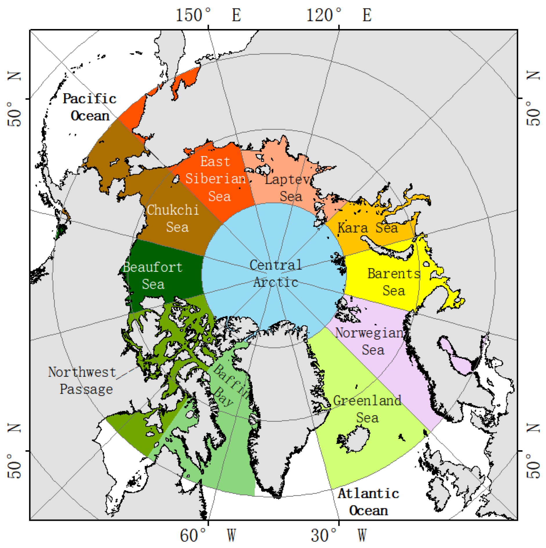
2.2. Sea Ice Concentration

SIC data are obtained from the daily Sea Ice density data of the University of Bremen (https://seaice.uni-bremen.de/data, accessed on 16 June 2022), which varies between 0 and 100%. The data products are generated by the ARTIST Sea Ice (ASI) algorithm. Daily SIC data from 2002 to the present are provided with a spatial resolution of 3.125 km × 3.125 km using a standard latitude and longitude grid for polar projections. This dataset utilized Advanced Microwave Scanning Radiometer for EOS (AMSR-E) class 1A data from NASA’s Aqua satellite and Advanced Microwave from JAXA’s GCOM-W1 satellite Scanning Radiometer 2 (AMSR2) level 1B data [41]. Daily SIC data from 2002 to 2021 were used to analyze the response relationship between SIC and SST in the Arctic. SIC data are missing from May 2002, May–June 2012, and November–December 2011 due to sensor failures. When the SIC is 100%, the absolute error is 5.7%, and the absolute error decreases with the increase in SIC [32].

2.3. Sea Ice Extent

The sea ice extent is derived from the U.S. National Ice Center (USNIC). USNIC has determined Arctic sea ice extent based on analysis using the USNIC’s Interactive Multi-Sensor Snow and Ice Mapping System (IMS), used in the Multisensor Analyzed Sea Ice Extent (MASIE) product, jointly created with the National Snow and Ice Data Center (NSIDC). The data download site is https://usicecenter.gov/Products/ (accessed on 3 October 2022). The daily sea ice boundary product utilizes a variety of near-real-time satellite data, buoy data, meteorological data, and reanalysis of the current sea ice conditions. USNIC uses this 3-day running average to calculate the ice extent to account for short-term spatial variation in sea ice edge location and to reduce subjectivity and variability in determining ice extent. The data format we downloaded is SHP. We used statistics from NSIDC and NASA to determine the dates of the maximum and minimum Arctic sea ice extent and added them to the melting and freezing results (Table 1). Sea ice extent in the Arctic typically reaches a maximum in March and a minimum in September.

3. Methods

3.1. Resampling Method

The annual, quarterly, and monthly average SST and SIC data are calculated by
X ¯ n = i = 1 n x i n
X ¯ n is the monthly average of the data, n is the number of days per month, and x i is the daily value of the point. Using daily data, we added up the values of a position point in the month and divided it by the corresponding days to obtain the monthly average value of the position point. The daily SST and SIC of the current month were averaged to create the spatial distribution of the monthly average [16,42]. Similarly, annual data were the annual average, and quarterly data were the seasonal average. The spatiotemporal variations of Arctic SST and SIC were analyzed.

3.2. Linear Regression Analysis

The linear regression equation can be expressed as:
y = b x + a
b = i = 1 n ( x i x ¯ ) ( y i y ¯ ) i = 1 n ( x i x ¯ ) 2 = i = 1 n x i y i n x ¯ y ¯ i = 1 n x i 2 n x ¯ 2 , a = y ¯ b x ¯
x ¯ = i = 1 n x i n , y ¯ = i = 1 n y i n
The independent variable x is time, the dependent variable y is SST or SIC, a is a constant, b is the regression coefficient, x ¯ is the average value of x , y ¯ is the average value of y , and n is the number. The linear regression method was used to calculate the change trend of SST and SIC.

3.3. Correlation Analysis

We calculated the correlation between two variables to represent their degree of relation, the correlation coefficient with covariance between the variables, and the standard deviation of the business in the range of (−1, 1), in which a negative correlation between them suggested a negative relation, a value of zero suggested no significant correlation between them, and a positive correlation suggested the two were positively related, thereby increasing or decreasing at the same time. The Pearson product moment correlation coefficient was used to represent the relationship between SST and SIC in the Artic, where X ¯ is the mean value of X and Y ¯ is the mean value of Y .
r = ( X X ¯ ) ( Y Y ¯ ) ( i = 1 n ( X i X ¯ ) 2 ) ( i = 1 n ( Y i Y ¯ ) 2 )

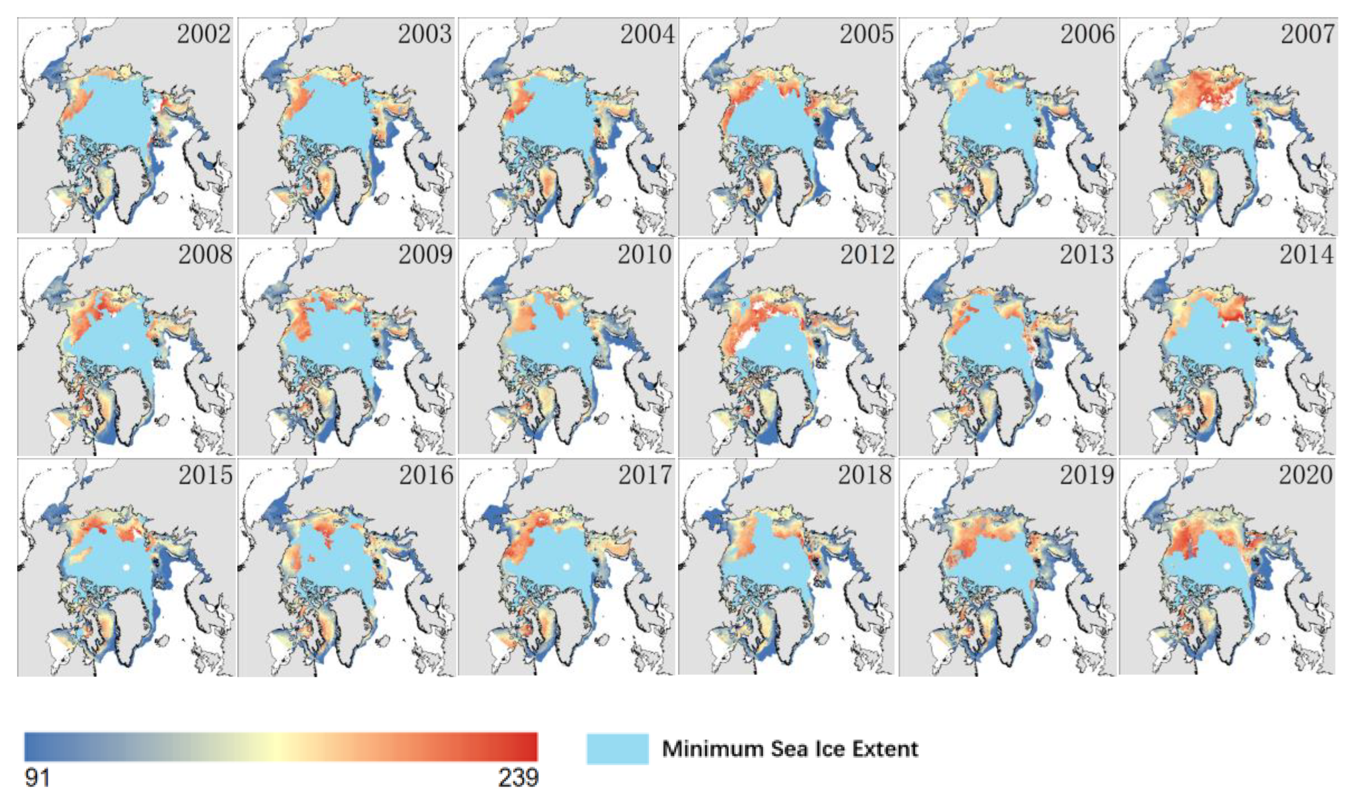
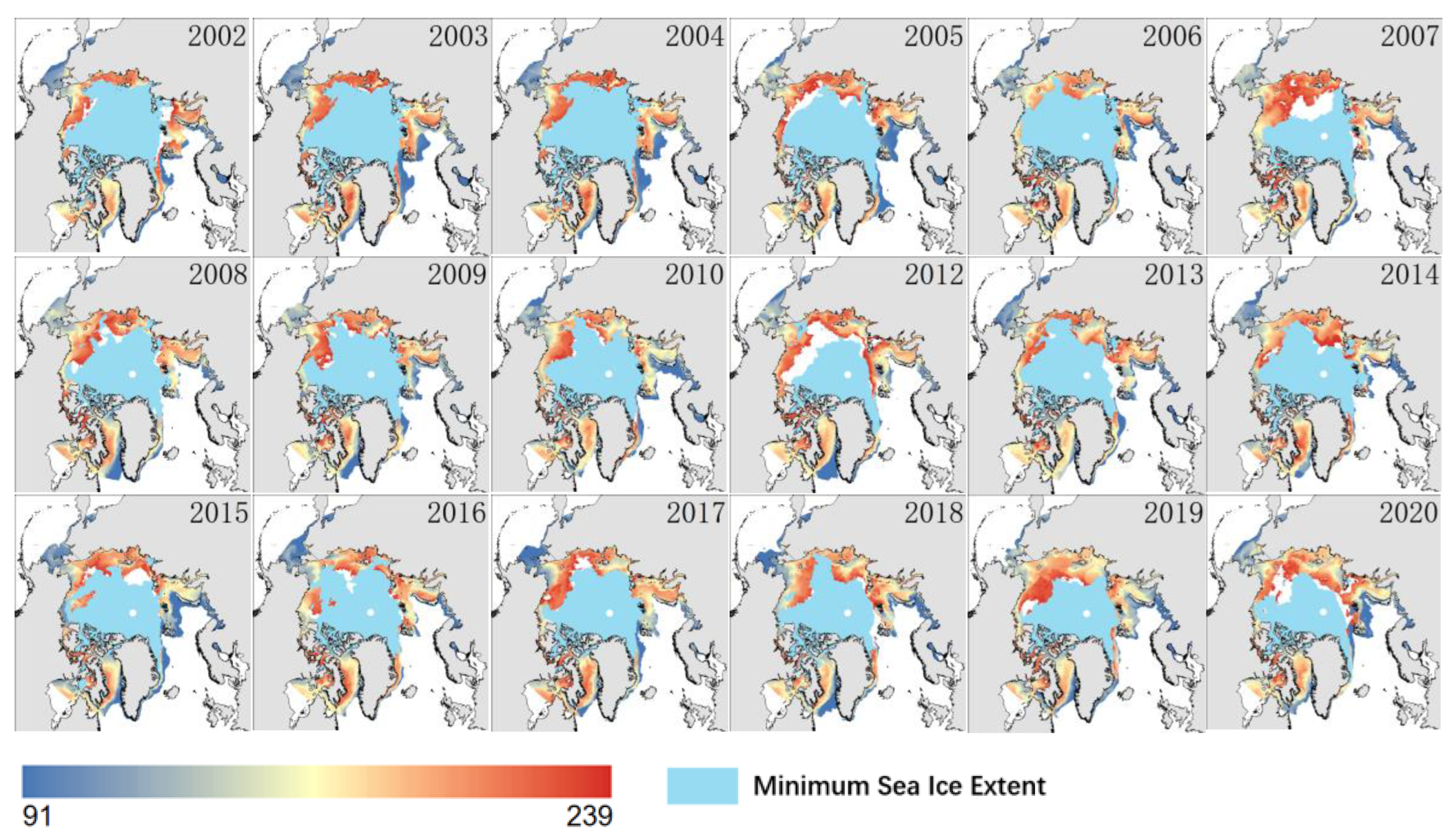
4. Definition of Sea Ice Melting and Freezing Processes

4.1. Sea Ice Break-Up and Melt Completely

The early and prolonged melting period of Arctic sea ice and ice snow has been one of the signals of accelerated Arctic climate warming in recent years [43]. SIC is an important indicator of sea ice melting and freezing [44]. Most studies define sea ice break-up as the date on which SIC falls below a specified threshold and remains below that threshold for a specified period of time [45]. We defined the sea ice break-up date as the first day when the SIC was less than 90% for five consecutive days, and the first day when the full melting state (open water) was less than 15% for five consecutive days [46]. The time period from the beginning of the melting state to the complete melting state is the rapid melting period. We used the summer months from April to August as the melting season [47].

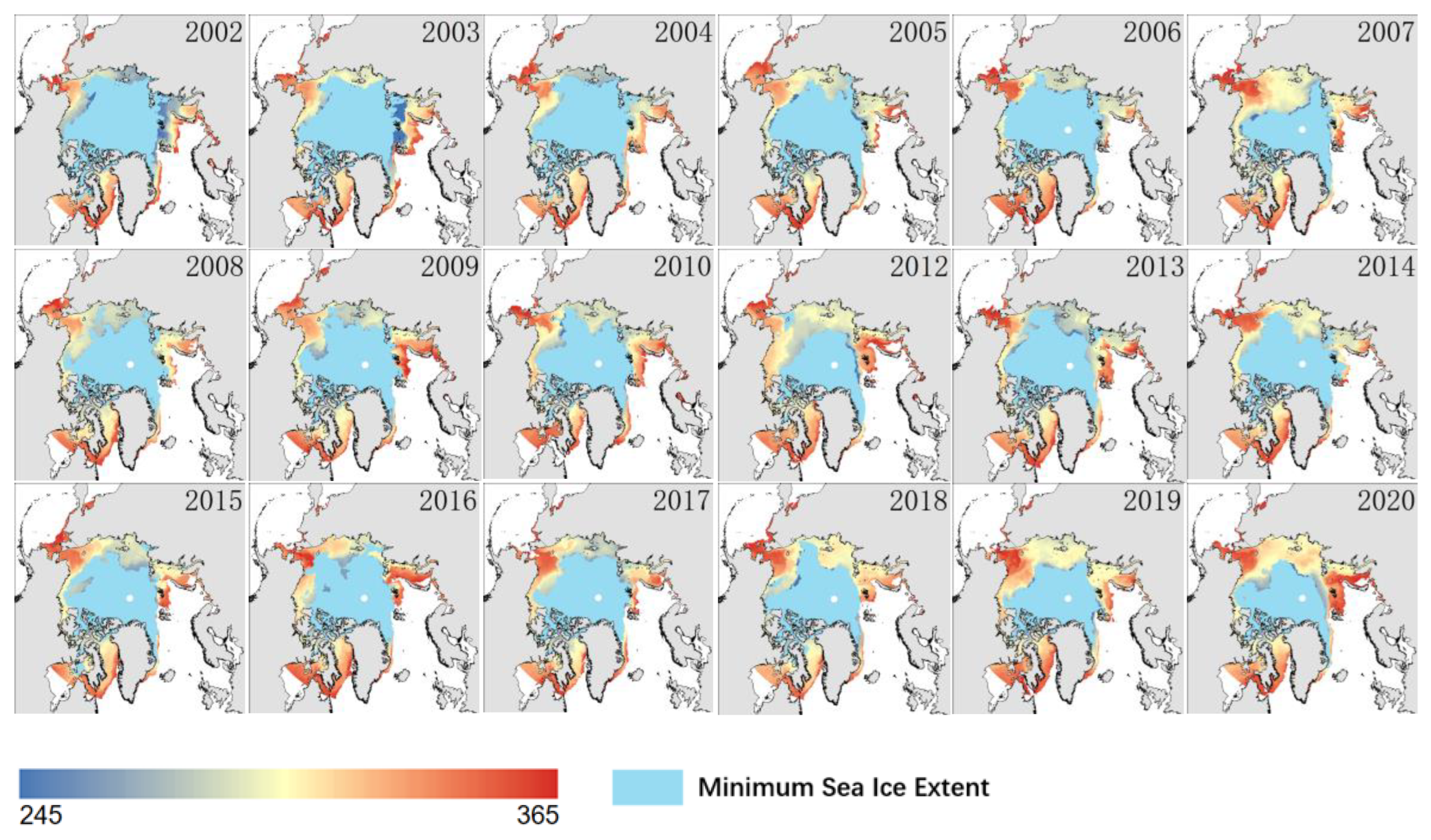
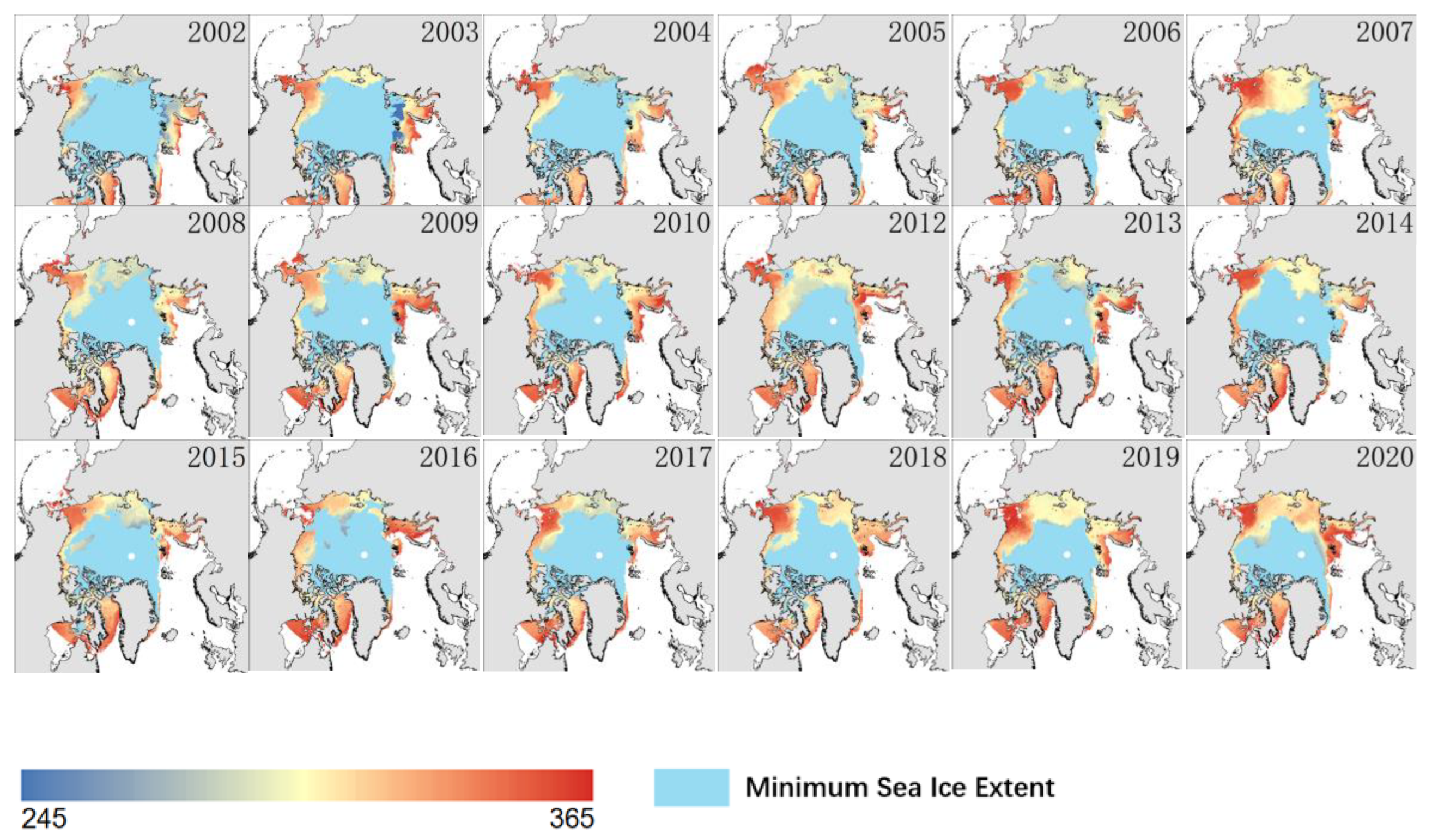
4.2. Sea Ice Freeze-Up and Freeze Completely

Among the many problems faced by the opening of the Arctic route, the rapid change in Arctic sea ice has formed a huge challenge. In November 2021, in the Arctic waters near Russia, there were ships trapped in the ice and unable to sail, primarily because they had not anticipated the change in the freezing situation of the sea ice in the region and had to wait for rescue by the icebreaker. Sea ice freeze-up was defined as the first day on which the SIC was greater than 15% for five consecutive days, and the complete freezing state was defined as the first day on which the SIC was greater than 90% for five consecutive days [48]. The period from the start to the full freeze state is the fast freeze period. The freezing season will be from September this year to March next year.

5. Result and Analysis

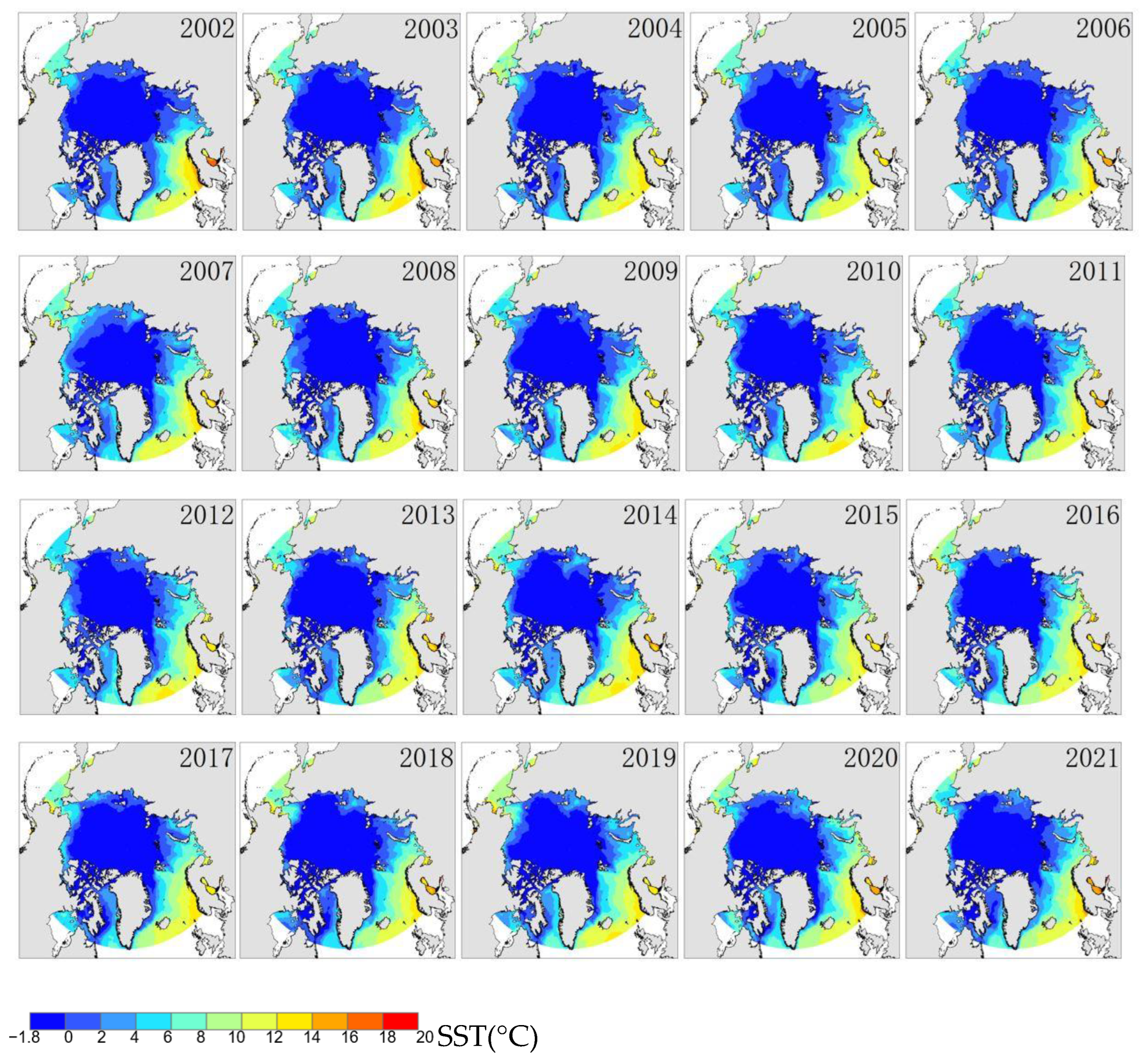
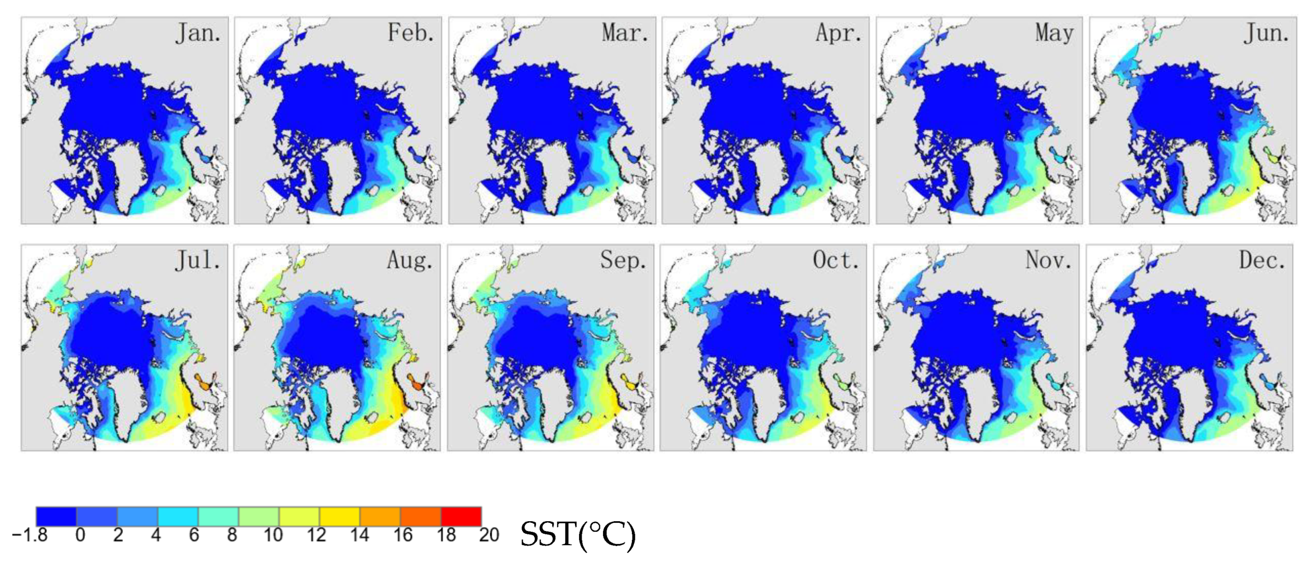
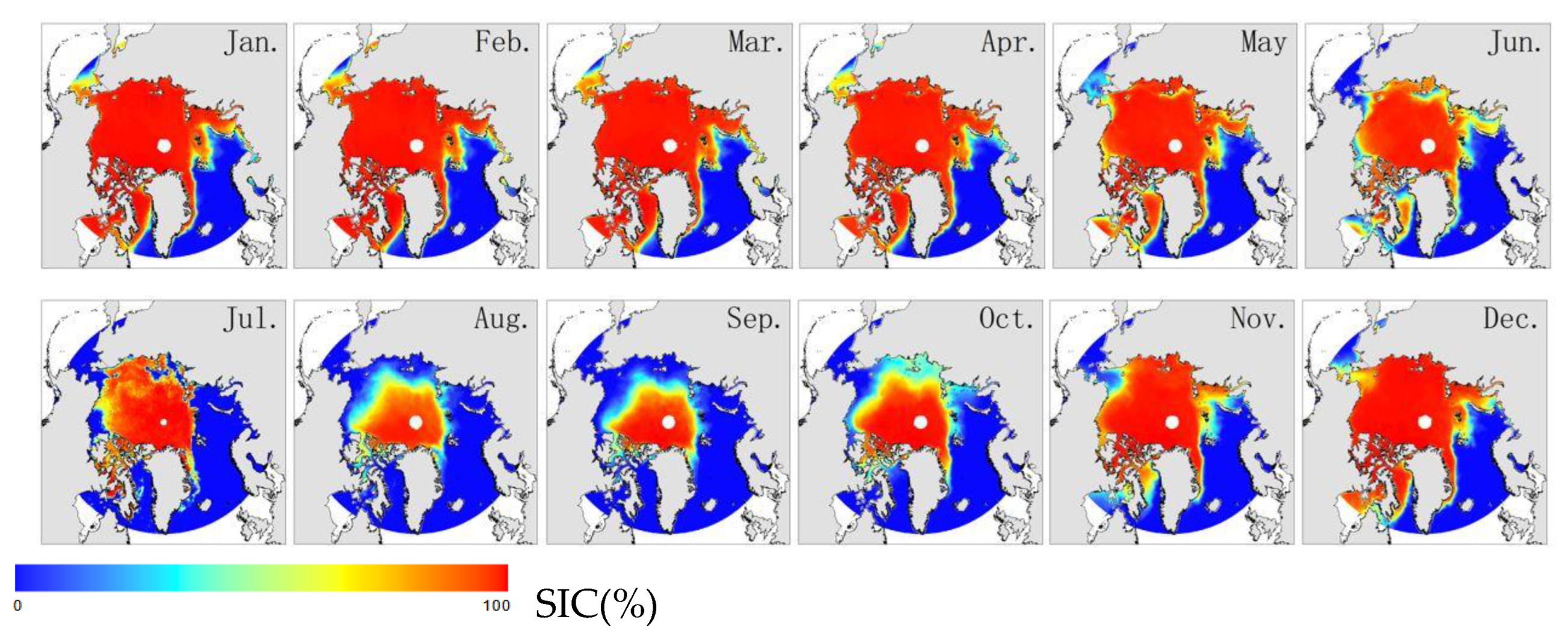
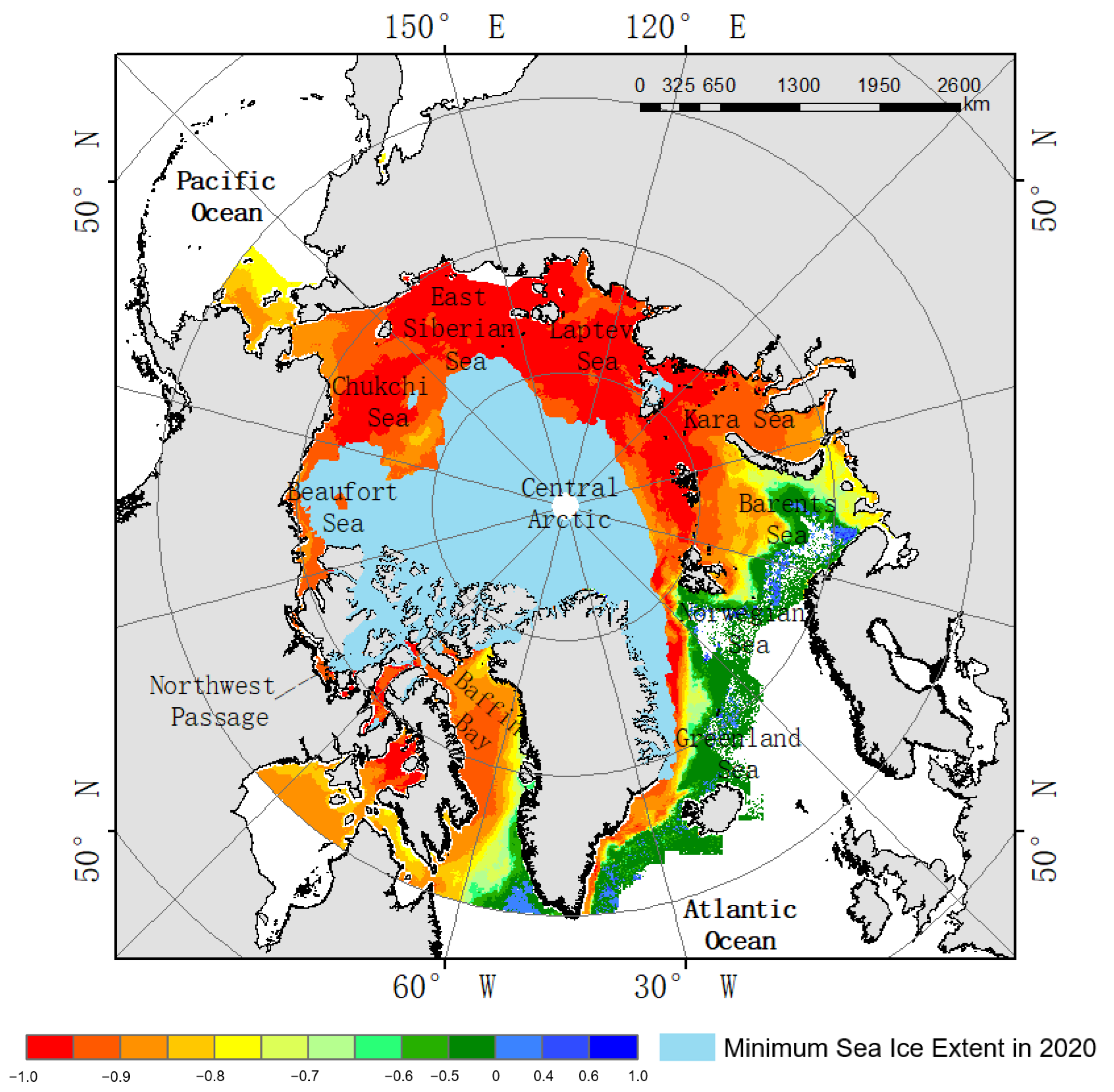
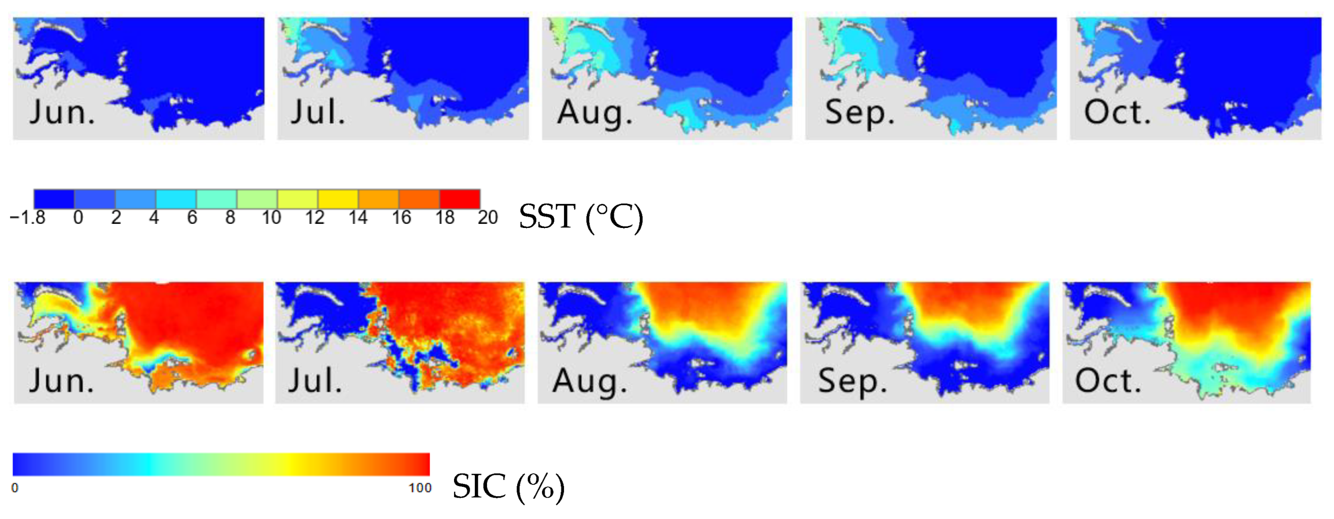
5.1. Spatiotemporal Variation of SST and Sea Ice

There are significant spatial differences between Arctic SST and SIC. The annual variation of the Arctic SST shows that the overall warming trend is not obvious, but some sea areas are warming significantly, and the annual average SST is −0.13 °C. The Norwegian Sea has the highest SST at 5.53 °C, followed by the Greenland Sea at 3.93 °C and the Barents Sea at 2.16 °C. The average annual SST below 0 °C is −0.99 °C in the Beaufort Sea, −0.74 °C in the Laptev Sea, −0.73 °C in the Northwest Passage, and −0.56 °C in the East Siberian Sea. Only the Kara Sea, Barents Sea, and Laptev Sea passed the significance test (p < 0.05), and the trends are 0.068 °C/year, 0.052 °C/year, and 0.044 °C/year, respectively. This indicates that the Northeast Passage is the area with the fastest rise in SST in the Arctic in recent years. The annual mean of Arctic SIC is approximately 50.29%, showing a significant downward trend of approximately −0.31%/year. The concentration of sea ice in the Beaufort Sea was the highest (80.92%), followed by the Northwest Passage (72.47%), Laptev Sea (70.71%), East Siberian Sea (70.38%), Chukchi Sea (57.41%), and Kara Sea (54.73%). The concentration of sea ice was lower in Baffin Bay (38.51%), the Barents Sea (15.22%), the Greenland Sea (12.42%), and the Norwegian Sea (3.23%). Among them, the Kara Sea has the largest decreasing trend of SIC of approximately −0.72%/year. The Laptev Sea, Chukchi Sea, Barents Sea, and Northwest Passage show a downward trend of −0.64%/year, −0.53%/year, −0.41%/year, and −0.26%/year, respectively. It can be seen that the Northeast Passage is the region with the fastest decline in SIC among the Arctic marginal waters in recent years.
The seasonal variation of SST is high in summer (June–August) and autumn (September–November) and low in winter (December–February) and spring (March–May).
The average temperature in winter, spring, summer, and autumn was −0.79 °C, −0.78 °C, 0.80 °C, and 0.35 °C, respectively. Only in autumn did the average temperature increase by 0.01 °C/year, and the other three seasons did not increase significantly. In winter, the Kara Sea had the most obvious warming trend (approximately 0.03 °C/year °C), followed by the Laptev Sea, East Siberian Sea, and Beaufort Sea. It is worth noting that, unlike other Arctic marginal seas, Baffin Bay has a cooling trend of −0.02 °C/year in winter. In spring, the Laptev Sea showed the largest warming trend (approximately 0.03 °C/year), followed by the Kara Sea, East Siberian Sea, and Beaufort Sea. In summer, the temperature of all sea areas is above 0 °C (Figure 2). The Kara Sea has the highest Arctic warming trend of 0.11 °C/year, followed by the Barents Sea with 0.09 °C/year and the Laptev Sea with 0.05 °C/year. In autumn, the Kara Sea is the sea area with the largest warming trend of 0.11 °C/year, followed by the Barents Sea, Laptev Sea, and Norwegian Sea.
Arctic SIC is low in summer and autumn and high in winter and spring (Table 2). The concentration of sea ice in autumn is the lowest and the decreasing trend is the largest. The SIC in spring is the highest and the decreasing trend is the lowest. The trend of SIC in summer, autumn, winter, and spring is −0.39%/year, −0.45%/year, −0.24%/year, and −0.23%/year, respectively. In winter, the downward trend of SIC in the Kara Sea and Chukchi Sea reaches −0.55%/year, and the Norwegian Sea, Northwest Passage, and East Siberian Sea also show a significant downward trend of SIC. In spring, the SIC decreases by −0.81%/year in the Barents Sea, −0.59%/year in the Chukchi Sea, −0.44%/year in the Kara Sea, and −0.22%/year in the East Siberian Sea and Beaufort Sea. In summer and autumn, the sea ice in the Arctic marginal waters is the least, and the seasonal average SIC is less than 70%. The SIC in the Northeast Passage decreased significantly in summer and autumn. The SIC of the Barents Sea, Kara Sea, and Laptev Sea decreased by −0.33%/year, −1.32%/year, and −1.51%/year in summer and −0.38%/year, −1.38%/year, and −1.49%/year in autumn, respectively. In terms of seasonal changes, SIC in the Arctic is the smallest and decreases significantly in summer and autumn, and the decreasing trend is most significant in the Northeast Passage.
On the monthly scale, the SST in the Arctic was low from November to June, and the SST in March was the lowest at approximately −0.94 °C (Figure 3). The SST is high from July to October, with the highest SST reaching approximately 1.55 °C in August, which is also the golden period for the passage of the Arctic shipping routes. In January, February, and May, the SST was above 0 °C in the Norwegian Sea, Barents Sea, and Greenland Sea, but all the other sea areas were below 0 °C. From March to April, only the Norwegian and Greenland Seas were above 0 °C. The Norwegian Sea, Barents Sea, Kara Sea, Greenland Sea, Baffin Bay, and Chukchi Sea showed the fastest warming in May-June, while the Laptev Sea showed the fastest warming in June-July. Since June, temperatures in the Chukchi Sea and Baffin Bay have risen above 0 °C. Although the SST of all the Arctic marginal seas is greater than 0 °C from July to September, the SST of all the Arctic seas shows a rapid decline from August to September, except for the Norwegian Sea and the Greenland Sea. From October to December, temperatures begin to cool again, but the Norwegian and Barents Seas remain above 0 °C. Arctic SIC is less than 50% from July to October and more than 50% from November to June. SIC was lowest in September at approximately 24% and highest in March at approximately 68% (Figure 4). February, April, June, October, October, May, September, July, June, and March show the greatest decline in SIC in the Norwegian Sea, Barents Sea, Kara Sea, Laptev Sea, East Siberian Sea, Chukchi Sea, Beaufort Sea, Northwest Passage, Baffin Bay, and Greenland Sea, respectively. Among them, the SIC of the Laptev Sea decreases the most, and the change trend of Arctic SIC has obvious regional characteristics.

5.2. Response of SST to Sea Ice Concentration

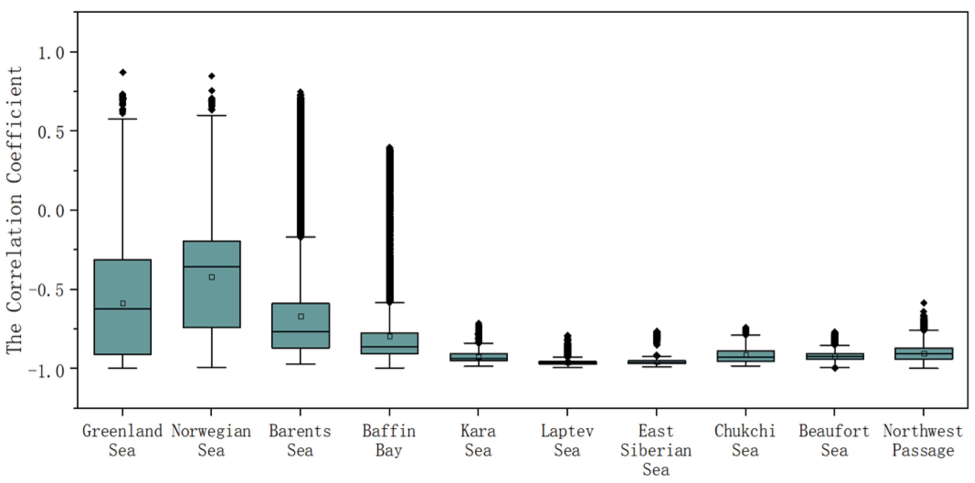
5.2.1. Correlation between SST and SIC

Within a pixel, there is both the SIC and SST, of which the SIC value represents the proportion of the area covered by sea ice and the SST represents the temperature of the remaining area. The same location can be used in different ways to indicate both SST and SIC. From 2002 to 2021, the annual average SST and SIC in the Arctic showed a significant trade-off (Table 3). From the waveform curve, the peaks of SST correspond to the troughs of SIC, the troughs of SST correspond to the peaks of SIC, and the intensity of the temperature changes is approximately the same as the change of SIC.
In addition, the Northeast Passage and Northwest Passage are vital for Arctic shipping. The ice conditions in the passage areas are complicated, and the changes in sea surface temperature and sea ice density are also sensitive. Four points were selected in the Kara Sea (68°0′49.07″N, 45°8′58.54″E), the Laptev Sea (79°4′58.08″N, 79°7′17.00″E), the Eastern Siberian Sea (74°1′51.64″N, 142°0′56.00″E), and the Northwest Passage (74°2′13.40″N, 97°5′58.00″W). One can observe how SST and SIC changed at each point in 2021 (Figure 5). From March to May before the summer melt season, the SIC changes repeatedly, and the sea ice underwent a freezing–melting–refreezing process until the real summer came when the sea ice completely melted, and by November, the sea ice froze again. This freeze–thaw phenomenon occurs in May–July when the sea ice begins to freeze again into winter in September after approximately two months of thawing. The sample in the East Siberian Sea is approximately the same as the sample in the Laptev Sea, but the freeze–thaw process is earlier and lasts for a shorter time around May–June. The Northwest Passage sample site is completely different from the other three sites, and the freeze–thaw process of sea ice occurs in March–May and the ice-free period is earlier and of a shorter duration. Starting in mid-June, over the following four months, the freeze–melt–refreeze process continued until the sea ice completely froze in mid-October. We found that there was a period of freeze–thaw–thaw cycles before and for some time after the complete melting of summer sea ice. During the sea ice change process before the complete melting of sea ice, the SST increases, and during the sea ice change process after the complete melting of sea ice, the SST decreases. Of course, these phenomena are related to the latitude of the four selected points and the position of the sea and land. To further explore this difference across Arctic seas and the relationship between SST and changes in SIC, we calculated correlation coefficients in the Arctic.
SST has a significant negative correlation with SIC (Figure 1), and the overall correlation coefficient of the study area is −0.82, which shows obvious regional differences under the influence of latitude and warm current (Figure 6). However, it is worth noting that the SST data are uniformly expressed as −1.8 °C at the pixel points where they are completely covered by ice. This may lead to a high correlation between SST and SIC. The negative correlation between SST and SIC is related to the polar amplification phenomenon. The loss of sea ice exposes the ocean to sunlight, and the ocean has a lower albedo, which absorbs more solar radiation and further promotes the melting of sea ice, forming positive feedback [49].
The correlation coefficients of the Norwegian Sea, Greenland Sea, and Barents Sea were −0.42, −0.59, and −0.67, respectively, showing a low correlation (Figure 7). On the side close to the North Atlantic, the correlation between SST and SIC is small, and even fails to pass the significance test of correlation, showing no correlation. The heat from the Atlantic enters the Arctic Ocean primarily through the Barents Sea, the Fram Strait, and the Davis Strait [50,51,52]. Since this part of the ocean is a conduit for warm water from the North Atlantic to the Arctic Ocean, eastern Greenland blocks the direct exchange of warm water with the North Pole, allowing warmer water to flow into this part of the ocean and bring more heat with it. As a result, SST has been high, there is relatively less sea ice, and the direct effect of SST on sea ice loss is also reduced. Other factors, such as ocean currents, air pressure, wind speed, and precipitation, are likely to play a stronger role in sea ice changes. The correlation coefficient between SST and SIC is −0.80 in Baffin Bay, which is located the west of the Greenland Sea. The southern part of Baffin Bay is more affected by the North Atlantic Warm current and the correlation coefficient is lower. The northern part is relatively more closed and less affected. The correlation coefficients of the Chukchi Sea, Beaufort Sea, and Northwest Passage are −0.91, −0.92, and −0.90, respectively. This part of the sea area is relatively closed, and the correlation between SST and SIC is enhanced. The Chukchi Sea is influenced by the warm waters of the Pacific Ocean flowing in through the Bering Strait [53], with less correlation in the south than in the north. The Beaufort Sea is located between the Chukchi Sea and the Northwest Passage, and the energy exchange between SST and sea ice is less affected by other factors. The waters of the Northwest Passage are characterized by small passages, and the Baffin Bay to the east cushions the influence of the North Atlantic Current. The correlation coefficients between SIC and SST in the Kara Sea, Laptev Sea, and East Siberian Sea are −0.93, −0.96, and −0.96, respectively, which are the regions with the largest correlation coefficients between SST and SIC in the Arctic marginal seas. Compared with other Arctic marginal seas, these sea areas are more closed. It is also the key sea area that determines whether the Northeast Passage is smoothly navigable. The negative correlation between SST and SIC is approximately −0.80 in the Kara Sea area north of Novaya Scala and near the Kara Strait because the warm water of the North Atlantic Ocean flows into the Kara Sea from the Kara Strait and north of Novaya Scala through the Barents Sea, which may be the reason for the relatively weak negative correlation in this part of the sea area. The Laptev Sea is a relatively closed sea area in the Northeast Passage, and there is a significant negative correlation between SST and SIC. The negative correlation between SST and SIC in the East Siberian Sea is strong in the east but weak in the west. This is due to the warm waters of the Pacific Ocean, which flow through the Chukchi Sea and enter from the eastern part of the East Siberian Sea, causing it to be affected.
Sea ice loss interacts with an increase in SST, especially in summer and fall. The rise in SST may delay the ice sealing in autumn, resulting in thinner sea ice, which is more likely to melt in the following summer, and the formation of an open water surface further promotes the rise in SST. As temperatures rise and sea ice melts, summer SIC values fall. This indicates that SST is closely related to sea ice and can be used as an effective parameter for sea ice prediction.

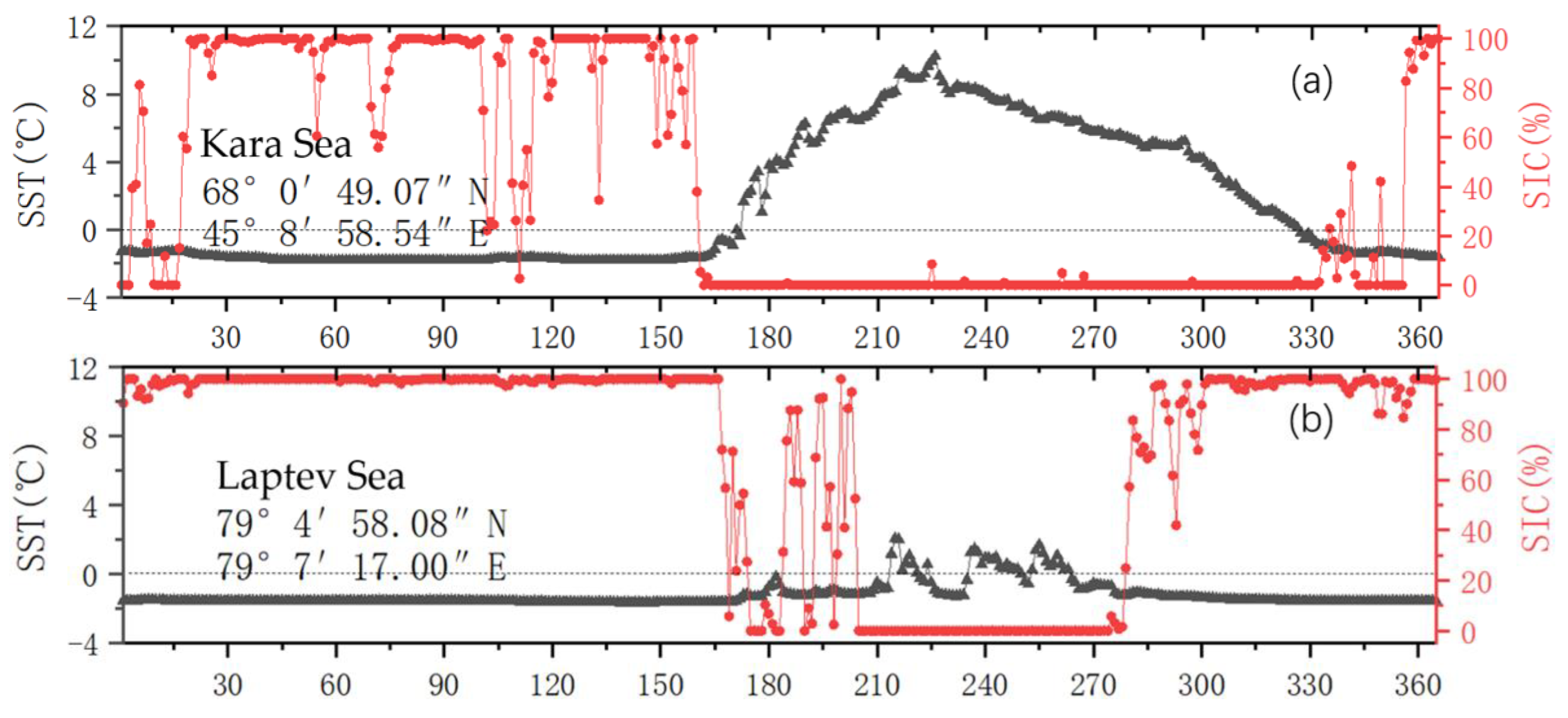
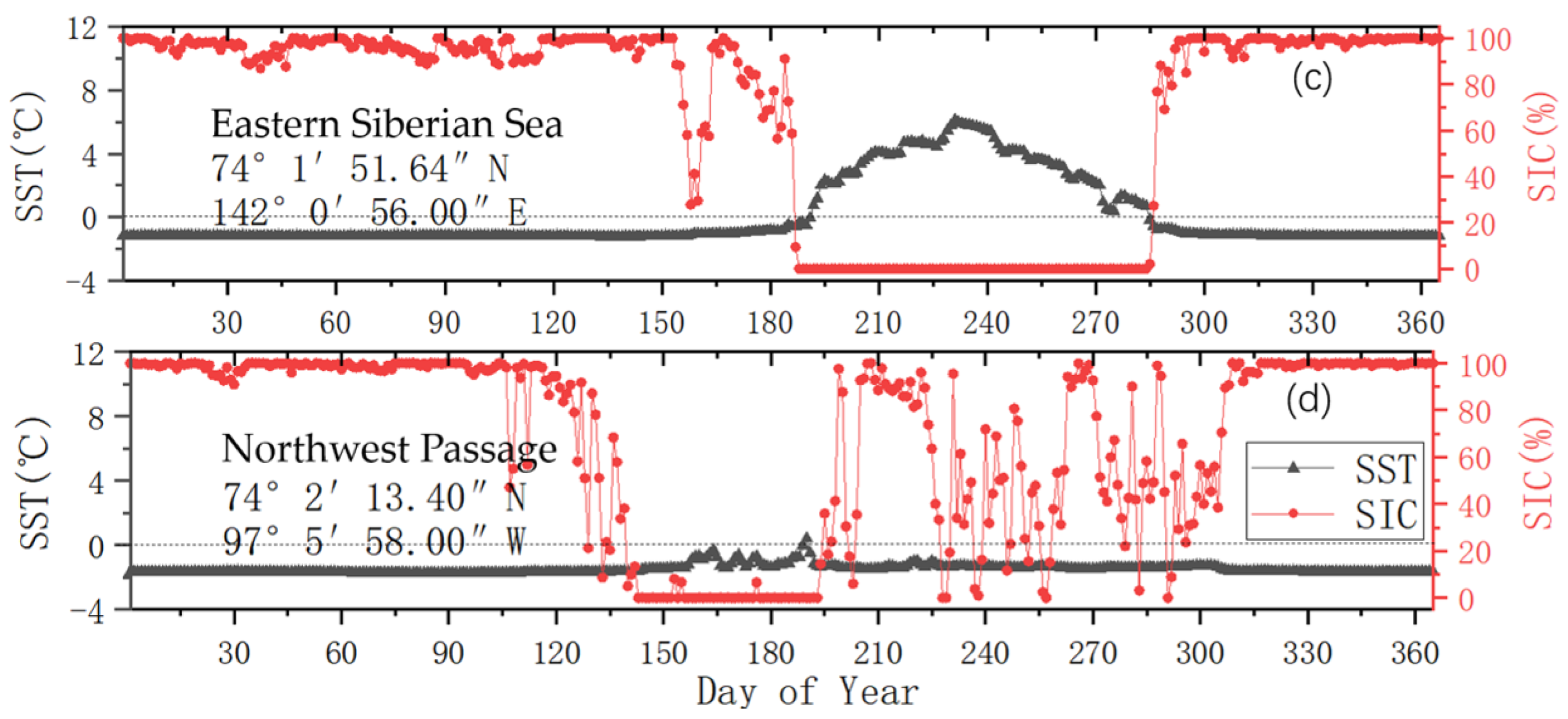
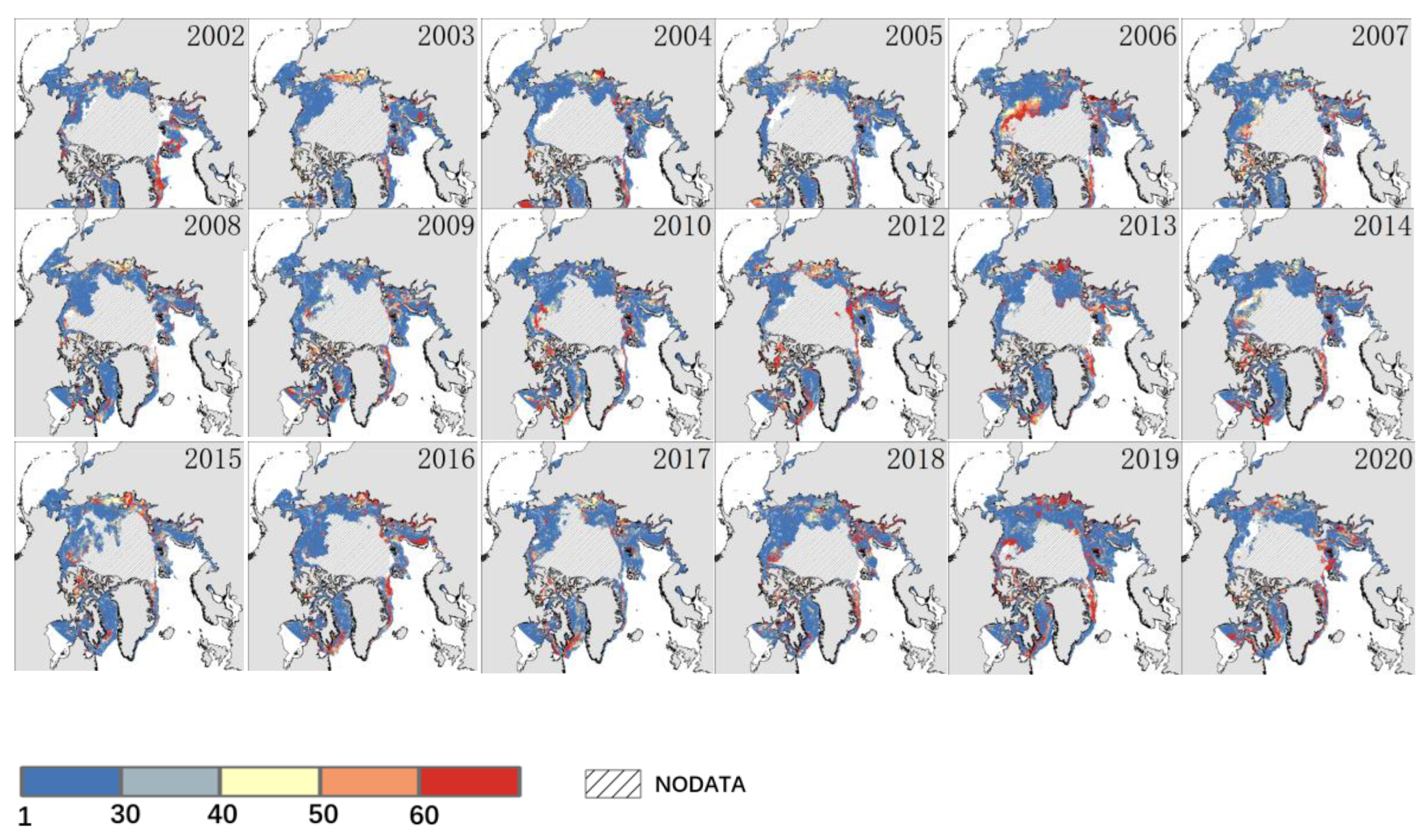
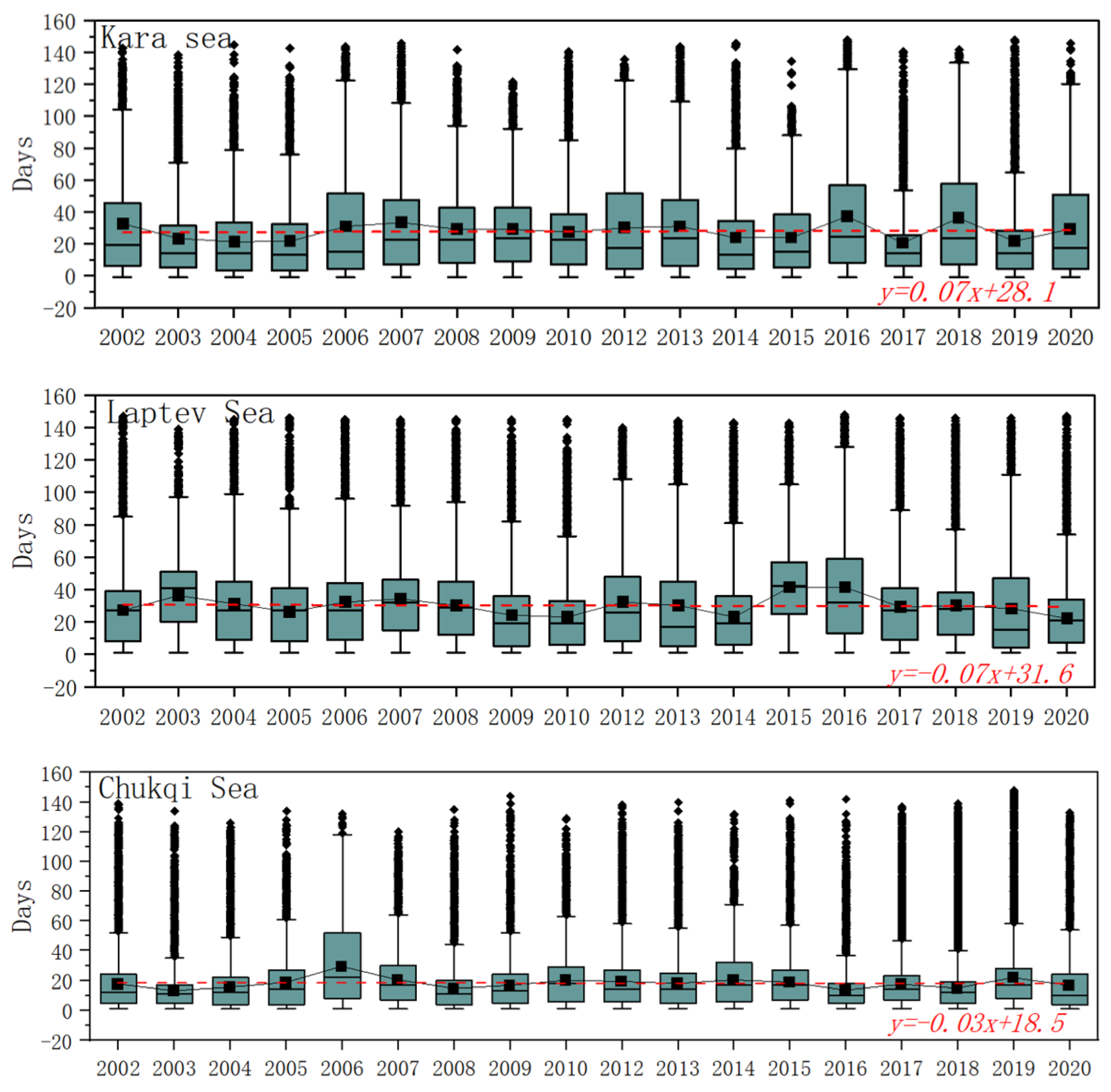
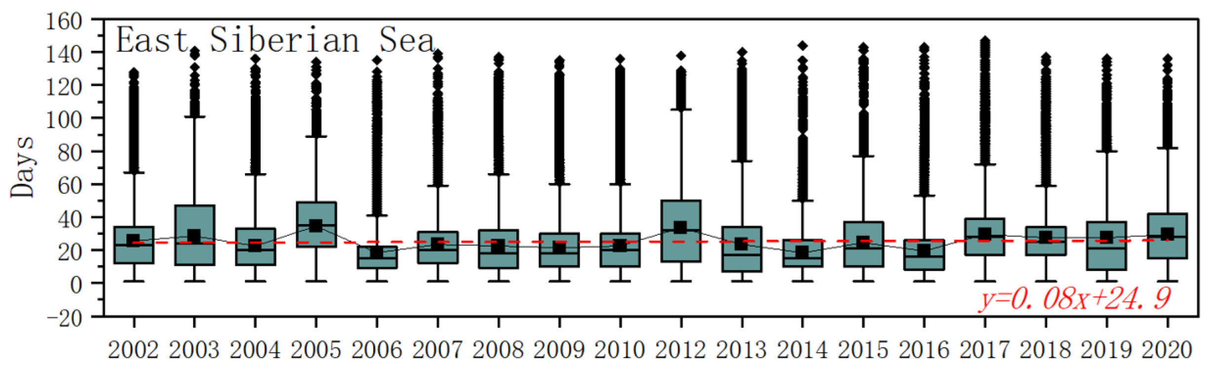
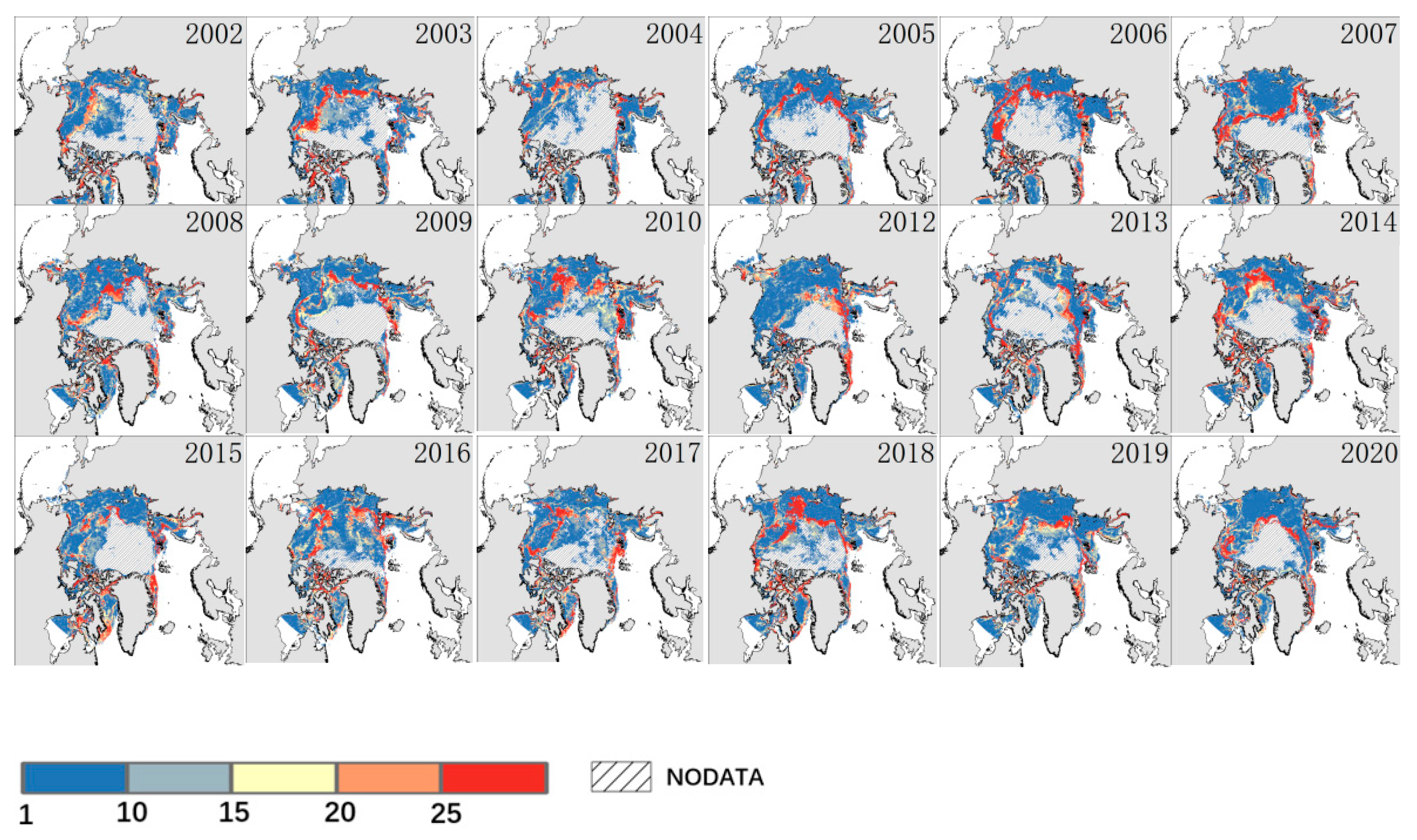
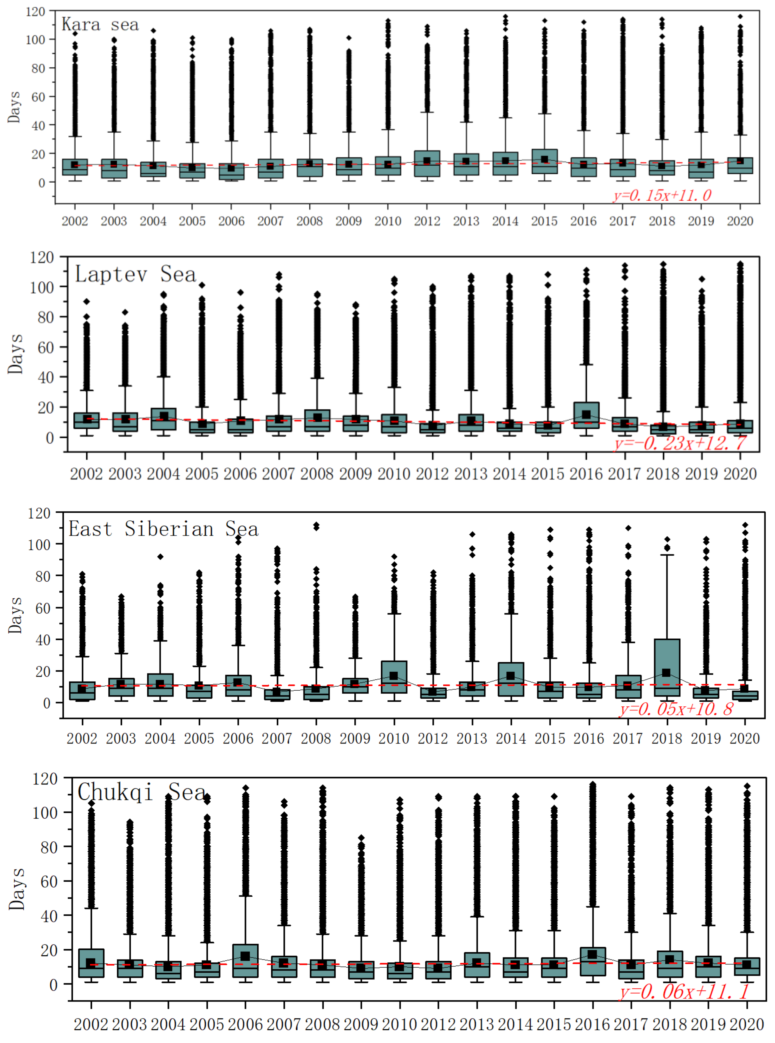
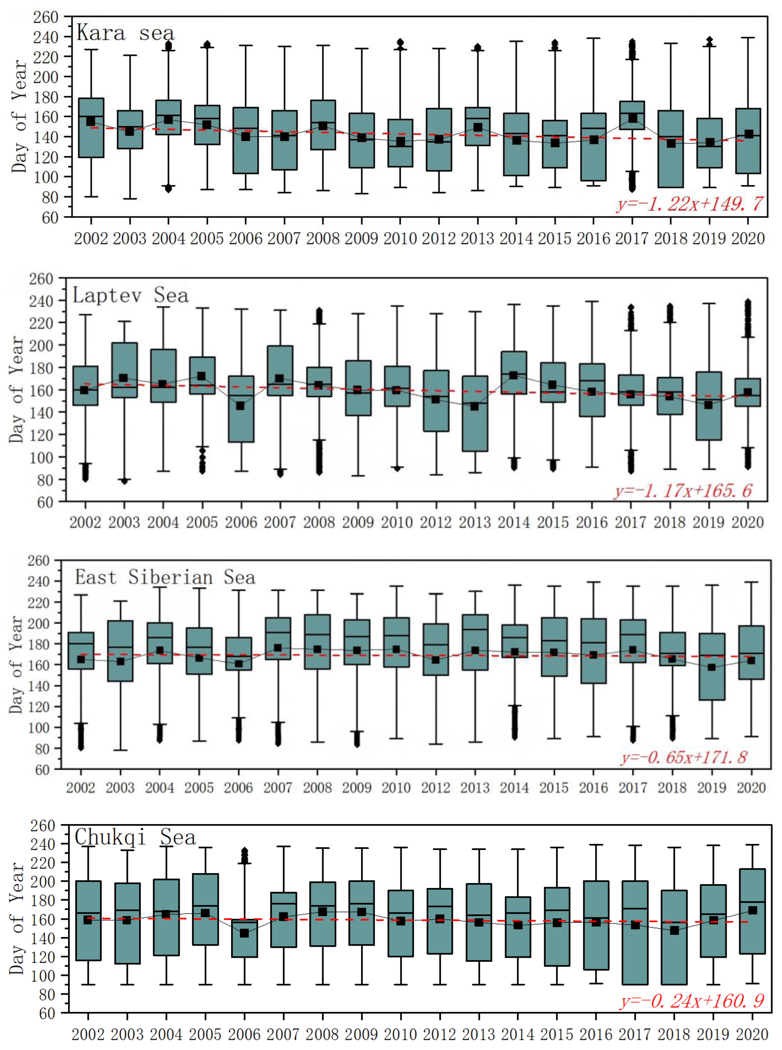
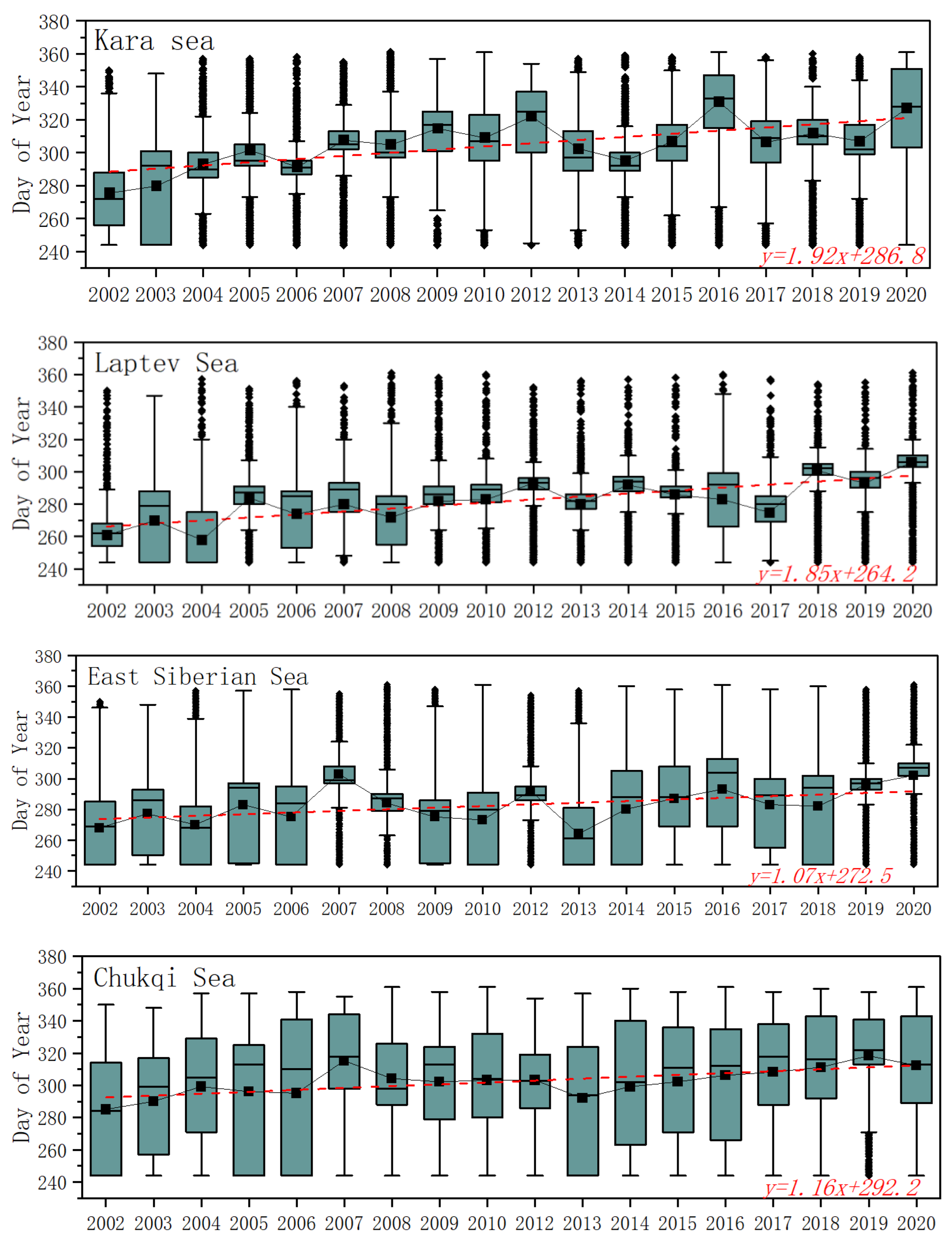
5.2.2. Melting and Freezing Processes of Sea Ice

In recent years, Arctic sea ice has continued to decrease and glacier melting has accelerated, resulting in the situation that Arctic sea ice melts earlier in summer and freezes later in autumn [54]. The melting and freezing of sea ice play a regulating role in the balance of surface material and energy, affecting the global water cycle process and the change in sea level, reflecting the changes in the Arctic environment, and affecting the arctic resources for mining and transportation, marine mammal migration, the arctic coastal countries’ residents living on the ice, and arctic shipping safety. Therefore, we further studied the thawing period of the Arctic marginal waters.
The Arctic sea ice break-up occurs from early April to the end of August each year (Figure 8), from approximately DoY 91 to 239 (Table 4). The break-up occurs, on average, in mid to late May on DoY 143 or May 23. The time to complete melting is around early June (Figure 9) on DoY 159 or June 8 (Table 5). The duration of melting varies greatly by sea area, with the Norwegian Sea beginning to melt the earliest on around April 6 (DoY 96). The Barents Sea and Greenland Sea ice break-up occurs on DoYs 105 and 102, respectively. This was followed by Baffin Bay and the Kara Sea, which started melting on DoYs 135 and 149. The Northwest Passage break-up occurs at similar times as the Laptev Sea on DoYs 162 and 166, respectively. The Beaufort Sea and the East Siberian Sea ice break-up occurs last, on or around June 25 (DoY 176). The Norwegian Sea reached full melting the earliest, on average on DoY 98, and was the fastest in the Arctic. The Greenland Sea and the Barents Sea melted on DoYs 108 and 115, respectively. Baffin Bay reached full melting on DoY 156. The Chukchi Sea and the Kara Sea were close on DoYs 170 and 177, respectively. The Beaufort Sea, the Northwest Passage, the East Siberian Sea, and the Laptev Sea were the last to reach full melting on DoYs 188, 191, 191, and 193, respectively.
The Arctic freezes from early September to the end of December (Figure 10), around DoY 245–365 (Table 6), and the onset of the freeze, on average, occurs in late October, around DoY 296 or October 23. The time to complete freeze is in early November, on DoY 305 or around 1 November. In the Arctic, the Beaufort Sea freeze-up occurs first on September 23 (DoY 266) and reaches full freeze the fastest on DoY 277. The Laptev Sea, East Siberian Sea, Northwest Passage, and Greenland Sea freeze-up and complete freeze occur at the same time (Table 7), starting to freeze on DoYs 282, 283, 283, and 287, respectively, and completely freeze on DoYs 292, 291, 295, and 297, respectively (Figure 11). The Kara Sea and Chukchi Sea freeze-up occurs on DoYs 305 and 303, respectively, and reaches full freeze on DoYs 315 and 309. In the Norwegian Sea and Baffin Bay, on either side of Greenland, freeze-up occurs on DoYs 313 and 319, respectively, and they reach full freeze on DoYs 317 and 327. The Barents Sea was the last to begin freezing, on November 19 (DoY 323), and the last to reach full freeze, on DoY 329.
The rapid melting (Figure 12 and Figure 13) and freezing (Figure 14 and Figure 15) processes lasted approximately 27 (Table 8) and 14 days (Table 9), respectively. However, there is no significant change in the rapid melting and freezing process. The Greenland Sea had the longest rapid melting period with 37 days, followed by the Northwest Passage with 36 days. The Laptev Sea, Kara Sea, East Siberian Sea, Beaufort Sea, Norwegian Sea, and Barents Sea experienced 31, 29, 26, 25, 23, and 22 days, respectively. The Chukchi Sea was the shortest, needing only 18 days to reach a fully melted state from the start. It takes only 11 days for the Laptev Sea and East Siberian Sea to reach full freeze, approximately 12 days for the Kara Sea and Chukchi Sea, 13 days for the Barents Sea, 14 days for Baffin Bay and the Beaufort Sea, 15 days for the Northwest Passage, and 18 days for the Greenland Sea to rapidly freeze. In the Norwegian Sea, it takes 20 days.

5.2.3. Early Melting and Late Freezing

Arctic sea ice melts earlier and freezes later [55]. During our study period, the trend of early melting of Arctic sea ice is very prominent in some sea areas (Figure 16), but the overall trend of early melting is not significant. The Kara Sea showed the most obvious trend of early melting, with the trend of the beginning of melting and complete melting being −1.22 d/year and −1.20 d/year, respectively. The Laptev Sea followed, with an early trend of −1.17 d/year for the beginning of melting and −0.99 d/year for the complete melting. In the Barents Sea, the advance trend of complete melting was −1.02 d/year and −0.76 d/year, respectively, faster than that of the beginning of melting. The East Siberian Sea also showed an obvious trend of early melting, with a trend of −0.65 d/year for the beginning of melting and −0.54 d/year for the complete melting. In addition, the Norwegian Sea also showed a slightly earlier trend, with the onset and complete melting time of −0.20 d/year and −0.22 d/year, respectively. It is worth noting that the Northwest Passage also showed an earlier trend of −0.55 d/year, but the time to complete melting was not significantly earlier. The trend of melting in the remaining Arctic marginal waters was not significant.
There is a significant delay of freezing in the Arctic as a whole, with a delayed trend of 0.65 d/year for the beginning of freezing and 0.69 d/year for the complete freezing, respectively. The trend of freezing delay in the Arctic is more significant than that of melting. The Kara Sea has the strongest delayed freezing trend in the Arctic, which is +1.92 d/year and +1.77 d/year, respectively (Figure 17). The Laptev Sea, which is adjacent to the Kara Sea, has the second most significant trend, with a delayed trend of +1.85 d/year onset and +1.61 d/year complete freezing. The Barents Sea followed, with a delayed trend of +1.38 d/year for onset and +1.64 d/year for complete freezing, respectively. In the East Siberian Sea and Chukchi Sea, the delay trend of sea ice freezing onset was +1.07 d/year and +1.16 d/year, respectively. In addition, the Beaufort Sea also showed a significantly delayed trend of sea ice freezing, with a delayed trend of +0.79 d/year and +0.78 d/year for the beginning of freezing and complete freezing time, respectively. The accelerated decline in SIC is associated with warmer water temperatures in the Pacific and rising heat flux in the Chukchi and Beaufort Seas, which delay the formation of sea ice [56]. The number of thawing days and freezing days in the Norwegian Sea and Kara Sea showed a significant increasing trend. The Northeast Passage, including the Barents Sea, Kara Sea, Laptev Sea, and East Siberian Sea, showed the largest trend of early and delayed Arctic melting and freezing among the Arctic marginal seas. This trend shows that in recent years, the earlier melting time and the later freezing time of the Northeast Passage expanded the navigation window and made the navigation time longer, which promoted the international economic exchanges using the Arctic route and brought great convenience to the navigation of the Arctic Passage.
There is also an interesting phenomenon that there is a clear circular band in space in the annual Arctic freezing days, and the number of freezing days in this range is significantly greater than on either side of the circular band, indicating that a long time passes between the beginning of freezing and complete freezing (Figure 14). In the range west of 120°E and west of 60°W, this band appears at approximately 75°N, and the other side of the band appears at approximately 82°N. This may be related to the different degrees of heat transport from the North Atlantic and the Pacific to the Arctic [57]. However, rising SST in both the North Atlantic and North Pacific will cause Arctic sea ice to melt faster [58]. On the side near the Atlantic, the band is closer to the North Pole, possibly due to the influence of warm currents that push it toward the North Pole. We suspect that the reason for this is that outside the band, the low latitudes of the Arctic are heavily influenced by the exchange of fresh water from land and heat from the Atlantic and Pacific oceans, and during freezing periods, these regional sources do not provide enough heat to allow the sea ice to completely freeze in a shorter period of time. The inner part of the band, near the North Pole, has a great deal of multi-year ice and less extensive melting, and if it does melt, it can quickly refreeze, so it exhibits a shorter freezing process. This band is located in an important position between the closed Arctic and the open ocean and represents the difference between the two Arctic environments.

6. Discussion

The difference in the Arctic marginal seas is greatly influenced by the North Atlantic current, which carries warm water northward [8] through the Bering Strait, providing an important source of fresh water and heat for the Arctic Ocean [59,60]. Atlantic Water (AW) and halocline waters flow along the Siberian shelf of the Laptev Sea as a triple-core current: The conventional Fram Strait Branch (FSB) and Barents Sea Branch (BSB) and the Arctic Shelf Break Branch (ASBB), which are important for the sea ice, heat balance, and ocean circulation in the Arctic Ocean [61]. AW sufficiently carries heat to the ocean surface, thinning Arctic sea ice and causing it to gradually retreat [62], and even melting several meters of sea ice in a few years [63,64]. This energy exchange occurs in atmosphere–ice–ocean interactions. The atmosphere and ocean interact via the interface at the sea surface, and the SST and sea ice are therefore crucial elements for atmosphere–ice–ocean interactions [65].
Heat transport through the Barents Sea is the primary source of internal variation in winter Arctic sea ice, affecting the entire Arctic Ocean [66]. The loss of sea ice in the central Arctic is primarily influenced by heat transported to the Arctic Ocean through the Fram Strait, which causes the sea ice at its bottom to melt [67]. The delay in freezing in the Laptev Sea caused by unusually prolonged warmth over northern Russia and the intrusion of the Atlantic current could have an Arctic chain reaction. On the other hand, the influence of freshwater rivers flowing into the Arctic on SST and the melting and freezing process of sea ice cannot be ignored. In the coastal zones where rivers such as the Ob River, Yenisey River, and Lena River flow into the Arctic, the SST increases and the SIC decreases (Figure 18). Increased runoff can affect various processes related to heat and salt diffusion, ultimately leading to an increase in advection heat and salt flowing into the Arctic [68]. Net sea-ice melt (~109–158 km3) is only present in years with high river water budgets [69]. More river runoff has been linked to more summer melt, as well as earlier freezing [70].
Changes in SST are not the only factor delaying the freezing of sea ice. Climate change will also push more warm Atlantic water towards the Arctic, affecting ice formation, which may accelerate the decline of Arctic sea ice. Surface circulation is primarily the transpolar drift across the Arctic Basin from Eastern Siberia and the Laptev Sea to the Fram Strait and the anticyclonic Beaufort Gyre in the Canada Basin [71]. The Arctic circulation is not only closely related to the Arctic Oscillation [72] but also plays an important role in ocean warming and sea ice decline. Sea ice motion with the anticyclonic flow of the Beaufort Gyre and Transpolar Drift Stream is evident. In addition, surface freshwater from six primary Arctic rivers is drawn toward the center of the Canadian Basin by the anticyclonic winds of the Beaufort High, ensuring the maintenance of the Arctic’s strong halocline stratification, which affects the growth of sea ice as it grows and moves [73].
The temperature response to sea ice loss may be temporally inconsistent with sea ice extent change [74], and the greatest impact of sea ice loss on the Arctic climate will occur from mid-autumn to late autumn, rather than in late summer when the sea ice extent is minimum. Seasonal Arctic sea ice usually goes through a cycle of melting and refreezing, with annual changes in SIC. However, for multi-year ice, even in summer, the sea ice intensity remains high, staying close to 100% [55]. The large area of multi-year ice near the North Pole is covered, and even if it melts, it only forms melt pools on the ice, making it difficult to accurately monitor its status. Due to a lack of observational data, there is not yet a comprehensive understanding of the effects of the thin ice freezing process, which is complicated by the formation of ice slime containing seawater exposed to the air [75]. Ice melting is influenced by precipitation [76,77], circulation [78], snow cover, water accumulation or drainage, ice thickness, wind direction or strength, air temperature, water depth [79], etc. The length of the melt season has been increasing in the Arctic at a rate of 5 days per decade [80]. During the warmest time of the year, the sea ice begins to melt, and liquid water begins to pool on its surface. Sea ice thickness also contributes to the length of the process [81].

7. Conclusions

Based on the daily SST dataset provided by NCEI and the daily SIC data of the University of Bremen, the changes in SST and SIC in the Arctic from 2002 to 2021 and their correlation were analyzed, and the changes in sea ice melting and freezing in the Arctic in the past two decades were discussed. The conclusions we drew are briefly discussed.
The highest and lowest monthly mean Arctic SST values occur in August and March, respectively, while the SIC is in March and September. The annual variation of the Arctic SST shows that the overall warming trend is not obvious. Compared with other marginal sea areas, only the Kara Sea, Barents Sea, and Laptev Sea showed a significant increase in SST, with a trend of 0.068 °C/year, 0.052 °C/year, and 0.044 °C/year, respectively. The annual mean of Arctic SIC shows a significant downward trend of approximately −0.31%/year. The trends of SST and SIC in autumn are the most significant, which are +0.01 °C/year and −0.45%/year, respectively.
There is a significant negative correlation between SST and SIC in the study area and the correlation coefficient is −0.82, but there are significant differences in different seas. The correlation is low at the entrance of the North Atlantic Ocean and high in the Northeast Passage area. The change in sea ice is influenced by more factors, primarily by the inflow of warm water from the North Atlantic and Pacific oceans. The Northeast Passage is relatively closed and has a more stable environment, with a stronger correlation between SST and SIC. It should be noted that partial sea ice in winter is completely covered, and the corresponding sea surface temperature data are expressed as nearly −1.8 °C, while partial sea area is ice-free in summer. As a result, the relationship between SST and SIC becomes complicated and difficult to quantify with accurate data, which is a problem to be solved in the follow-up work.
The sea ice break-up occurs on DoY 143 and freeze-up occurs on DoY 296 in the Arctic. The sea ice break-up occurs first in the Norwegian Sea and last in the East Siberian Sea. The duration of rapid melting and freezing is 27 and 14 days, respectively. However, the rapid melting and freezing processes do not significantly increase or decrease. The sea ice break-up is advanced and the freeze-up is delayed, and the trend toward earlier melting is smaller than the trend toward later freezing. The Northeast Passage is the sea area with the most significant advance of sea ice melting and the Kara Sea has the strongest trend of −1.22 d/year, followed by the Laptev Sea ay −1.17 d/year. The delay trend of sea ice freezing was most significant in the Kara Sea with +1.75 d/year, followed by the Laptev Sea with +1.70 d/year. However, there is a dynamic process of ice to take into account, as the wind and the ocean cause the sea ice to drift. Ice undergoes deformation and thermal processes that cause it to grow, melt, and break up.
By analyzing the temporal and spatial characteristics and variation trends of SST and SIC in the Arctic, as well as the changes in the rapid melting and freezing of sea ice in the Arctic, it is more helpful to understand the environmental changes in the Arctic, especially the significant changes in the Northeast Passage compared with other marginal sea areas, which is of great significance to shipping in the Arctic. However, this paper does not consider the influence of other factors such as ocean currents, and further research is needed.

Author Contributions

Conceptualization, Y.Q. and M.Y.; methodology, M.Y. and Y.Q.; project administration, Y.Q. and J.C.; supervision, Y.Q.; visualization, Z.J.; writing—original draft, M.Y.; writing—review and editing, Y.Q., M.Y., L.H., M.C. and B.C. All authors have read and agreed to the published version of the manuscript.

Funding

This research was funded by the National Key Research and Development Program of China (No. 2019YFE0105700 and No. 2017YFE0111700), the Innovative Research Program of the International Research Center of Big Data for Sustainable Development Goals (No. CBAS2022IRP08), the Strategic Priority Research Program of the Chinese Academy of Sciences (No. XDA19070201) and the International Partnership Program of Chinese Academy of Sciences “Remote Sensing and Modeling of the Snow and Ice Physical Process (RSMSIP, No. 313GJHZ2022054MI)”.

Data Availability Statement

The sea surface temperature data OISST Version 2.1 are from the National Centers for Environmental Information (NCEI, https://www.ncei.noaa.gov/, accessed on 16 June 2022), the sea ice concentration data are from the University of Bremen (https://seaice.uni-bremen.de/data, accessed on 16 June 2022), and the sea ice extent data are from the U.S. National Ice Center (USNIC, https://usicecenter.gov/Products/, accessed on 3 October 2022).

Acknowledgments

The authors would like to thank the National Centers for Environmental Information, the University of Bremen, and the U.S. National Ice Center. Moreover, we thank the Digital Belt and Road (DBAR) program Working Group on the High Mountain and Cold Regions (HiMAC) and the Digital Arctic Shipping-New Data Products and Visualisation Services (DARC-SERV).

Conflicts of Interest

The authors declare no conflict of interest.

References

  1. Graversen, R.G.; Mauritsen, T.; Tjernström, M.; Källén, E.; Svensson, G. Vertical structure of recent Arctic warming. Nature 2008, 451, 53–56. [Google Scholar] [CrossRef] [PubMed]
  2. Cao, Y.; Liang, S. Recent advances in driving mechanisms of the Arctic amplification: A review. Chin. Sci. Bull. 2018, 63, 2757–2774. [Google Scholar] [CrossRef] [Green Version]
  3. Chylek, P.; Folland, C.; Klett, J.D.; Wang, M.; Hengartner, N.; Lesins, G.; Dubey, M.K. Annual Mean Arctic Amplification 1970–2020: Observed and Simulated by CMIP6 Climate Models. Geophys. Res. Lett. 2022, 49, e2022GL099371. [Google Scholar] [CrossRef]
  4. Parracho, A.C.; Safieddine, S.; Lezeaux, O.; Clarisse, L.; Whitburn, S.; George, M.; Prunet, P.; Clerbaux, C. IASI-Derived Sea Surface Temperature Data Set for Climate Studies. Earth Space Sci. 2021, 8, e2020EA001427. [Google Scholar] [CrossRef]
  5. Donlon, C.J.; Martin, M.; Stark, J.; Roberts-Jones, J.; Fiedler, E.; Wimmer, W. The Operational Sea Surface Temperature and Sea Ice Analysis (OSTIA) system. Remote Sens. Environ. 2012, 116, 140–158. [Google Scholar] [CrossRef]
  6. Bell, M.J.; Forbes, R.M.; Hines, A. Assessment of the FOAM global data assimilation system for real-time operational ocean forecasting. J. Mar. Syst. 2000, 25, 1–22. [Google Scholar] [CrossRef]
  7. Martin, M.J.; Hines, A.; Bell, M.J. Data assimilation in the FOAM operational short-range ocean forecasting system: A description of the scheme and its impact. Q. J. R. Meteorol. Soc. 2007, 133, 981–995. [Google Scholar] [CrossRef]
  8. Marullo, S.; Minnett, P.J.; Santoleri, R.; Tonani, M. The diurnal cycle of sea-surface temperature and estimation of the heat budget of the Mediterranean Sea. J. Geophys. Res. Ocean. 2016, 121, 8351–8367. [Google Scholar] [CrossRef]
  9. Copernicus Ocean State Report, issue 6. J. Oper. Oceanogr. 2022, 15, 1–220. [CrossRef]
  10. Zheng, C.; Zhou, L.; Song, S.; Pan, J. Long term trend of global sea surface temperature from 1870 to 2011. J. Oceanol. Limnol. 2013, 5, 1123–1129. [Google Scholar]
  11. Carvalho, K.S.; Wang, S. Sea surface temperature variability in the Arctic Ocean and its marginal seas in a changing climate: Patterns and mechanisms. Glob. Planet. Chang. 2020, 193, 103265. [Google Scholar] [CrossRef]
  12. Qi, Q.; Cai, R. The relationship between the oscillation of western Pacific warm pool and sea surface temperature anomalies in equatorial central and eastern Pacific. Mar. Sci. 2015, 9, 77–85. [Google Scholar] [CrossRef]
  13. Qiu, Y.; Massimo, M.; Li, X.; Birendra, B.; Joni, K.; Narantuya, D.; Liu, S.; Gao, Y.; Cheng, B.; Wu, T.; et al. Observing and understanding high mountain and cold regions using big earth data. Bull. Chin. Acad. Sci. 2017, 32, 82–94. [Google Scholar]
  14. Docquier, D.; Koenigk, T. A review of interactions between ocean heat transport and Arctic sea ice. Environ. Res. Lett. 2021, 16, 123002. [Google Scholar] [CrossRef]
  15. Leppäranta, M. Drift ice material. In The Drift of Sea Ice, 2nd ed.; Springer: Heidelberg, Germany, 2011; pp. 11–63. [Google Scholar] [CrossRef]
  16. Kodaira, T.; Waseda, T.; Nose, T.; Inoue, J. Record high Pacific Arctic seawater temperatures and delayed sea ice advance in response to episodic atmospheric blocking. Sci. Rep. 2020, 10, 20830. [Google Scholar] [CrossRef] [PubMed]
  17. Shen, X.; Zhang, Y.; Chen, C.; Hu, S. Long-term spatial and temporal variations of sea ice in the northwest passage of the Canadian Arctic Archipelago. Chin. J. Polar Res. 2021, 33, 71–87. [Google Scholar] [CrossRef]
  18. Buixadé Farré, A.; Stephenson, S.R.; Chen, L.; Czub, M.; Dai, Y.; Demchev, D.; Efimov, Y.; Graczyk, P.; Grythe, H.; Keil, K.; et al. Commercial Arctic shipping through the Northeast Passage: Routes, resources, governance, technology, and infrastructure. Polar Geogr. 2014, 37, 298–324. [Google Scholar] [CrossRef] [Green Version]
  19. Stephenson, S.R.; Wang, W.; Zender, C.S.; Wang, H.; Davis, S.J.; Rasch, P.J. Climatic Responses to Future Trans-Arctic Shipping. Geophys. Res. Lett. 2018, 45, 9898–9908. [Google Scholar] [CrossRef]
  20. Wagner, P.M.; Hughes, N.; Bourbonnais, P.; Stroeve, J.; Rabenstein, L.; Bhatt, U.; Little, J.; Wiggins, H.; Fleming, A. Sea-ice information and forecast needs for industry maritime stakeholders. Polar Geogr. 2020, 43, 160–187. [Google Scholar] [CrossRef]
  21. Melia, N.; Haines, K.; Hawkins, E.; Day, J.J. Towards seasonal Arctic shipping route predictions. Environ. Res. Lett. 2017, 12, 084005. [Google Scholar] [CrossRef] [Green Version]
  22. Simmonds, I.; Keay, K. Extraordinary September Arctic sea ice reductions and their relationships with storm behavior over 1979–2008. Geophys. Res. Lett. 2009, 36, L19715. [Google Scholar] [CrossRef]
  23. Keay, K.; Burke, C.; Simmonds, I. Arctic Climate Change as Manifest in Cyclone Behavior. J. Clim. 2008, 21, 5777–5796. [Google Scholar] [CrossRef]
  24. Rudeva, I.; Simmonds, I. Variability and Trends of Global Atmospheric Frontal Activity and Links with Large-Scale Modes of Variability. J. Clim. 2015, 28, 3311–3330. [Google Scholar] [CrossRef]
  25. Kumar, A.; Yadav, J.; Mohan, R. Spatio-temporal change and variability of Barents-Kara sea ice, in the Arctic: Ocean and atmospheric implications. Sci. Total Environ. 2021, 753, 142046. [Google Scholar] [CrossRef]
  26. Chen, J.; Kang, S.; You, Q.; Zhang, Y.; Du, W. Projected changes in sea ice and the navigability of the Arctic Passages under global warming of 2 °C and 3 °C. Anthropocene 2022, 40, 100349. [Google Scholar] [CrossRef]
  27. Landy, J.C.; Dawson, G.J.; Tsamados, M.; Bushuk, M.; Stroeve, J.C.; Howell, S.E.L.; Krumpen, T.; Babb, D.G.; Komarov, A.S.; Heorton, H.D.B.S.; et al. A year-round satellite sea-ice thickness record from CryoSat-2. Nature 2022, 609, 517–522. [Google Scholar] [CrossRef]
  28. Zheng, L.; Cheng, X.; Chen, Z.; Liang, Q. Delay in Arctic Sea Ice Freeze-Up Linked to Early Summer Sea Ice Loss: Evidence from Satellite Observations. Remote Sens. 2021, 13, 2162. [Google Scholar] [CrossRef]
  29. Carmack, E.; Polyakov, I.; Padman, L.; Fer, I.; Hunke, E.; Hutchings, J.; Jackson, J.; Kelley, D.; Kwok, R.; Layton, C.; et al. Toward Quantifying the Increasing Role of Oceanic Heat in Sea Ice Loss in the New Arctic. Bull. Am. Meteorol. Soc. 2015, 96, 2079–2105. [Google Scholar] [CrossRef]
  30. Gallaher, S.G.; Stanton, T.P.; Shaw, W.J.; Cole, S.T.; Toole, J.M.; Wilkinson, J.P.; Maksym, T.; Hwang, B. Evolution of a Canada Basin ice-ocean boundary layer and mixed layer across a developing thermodynamically forced marginal ice zone. J. Geophys. Res. Ocean. 2016, 121, 6223–6250. [Google Scholar] [CrossRef] [Green Version]
  31. Wilkinson, J.; Doble, M.; Valcic, L.; Veyssiere, G.; Cole, S.; Rainville, L.; Lee, C.; Hargrove, J.; DiLeo, J.; Graber, H. A fundamental shift in the melt processes of Arctic sea ice. Prepr. (Version 1) Available Res. Sq. 2020, 6–7. [Google Scholar] [CrossRef]
  32. Reynolds, R.W.; Banzon, V.F.; NOAA CDR Program. NOAA Optimum Interpolation 1/4 Degree Daily Sea Surface Temperature (OISST) Analysis, Version 2. In NOAA National Centers for Environmental Information; NOAA: Washington, DC, USA, 2008. [Google Scholar] [CrossRef]
  33. Schlax, M.G.; Casey, K.S.; Chelton, D.B.; Liu, C.; Smith, T.M.; Reynolds, R.W. Daily High-Resolution-Blended Analyses for Sea Surface Temperature. J. Clim. 2007, 20, 5473–5496. [Google Scholar] [CrossRef]
  34. Jo, Y.-H.; Yan, X.-H.; Pan, J.; He, M.-X.; Liu, W.T. Calculation of the Bowen ratio in the tropical Pacific using sea surface temperature data. J. Geophys. Res. Ocean. 2002, 107, 17-11–17-16. [Google Scholar] [CrossRef]
  35. Saha, K.; Ignatov, A.; Liang, X.M.; Dash, P. Selecting a first-guess sea surface temperature field as input to forward radiative transfer models. J. Geophys. Res. Ocean. 2012, 117, C12001. [Google Scholar] [CrossRef]
  36. Alpert, A.E.; Cohen, A.L.; Oppo, D.W.; DeCarlo, T.M.; Gove, J.M.; Young, C.W. Comparison of equatorial Pacific sea surface temperature variability and trends with Sr/Ca records from multiple corals. Paleoceanography 2016, 31, 252–265. [Google Scholar] [CrossRef] [Green Version]
  37. Benthuysen, J.A.; Oliver, E.C.J.; Feng, M.; Marshall, A.G. Extreme Marine Warming Across Tropical Australia During Austral Summer 2015–2016. J. Geophys. Res. Ocean. 2018, 123, 1301–1326. [Google Scholar] [CrossRef]
  38. Huang, B.; Liu, C.; Banzon, V.F.; Freeman, E.; Graham, G.; Hankins, B.; Smith, T.M.; Zhang, H.-m.J.J.o.C. Improvements of the Daily Optimum Interpolation Sea Surface Temperature (DOISST) Version 2.1. J. Clim. 2020, 34, 2923–2939. [Google Scholar] [CrossRef]
  39. Banzon, V.; Smith, T.M.; Steele, M.; Huang, B.; Zhang, H.-M. Improved Estimation of Proxy Sea Surface Temperature in the Arctic. J. Atmos. Ocean. Technol. 2020, 37, 341–349. [Google Scholar] [CrossRef]
  40. Banzon, V.; Smith, T.M.; Chin, T.M.; Liu, C.; Hankins, W. A long-term record of blended satellite and in situ sea-surface temperature for climate monitoring, modeling and environmental studies. Earth Syst. Sci. Data 2016, 8, 165–176. [Google Scholar] [CrossRef] [Green Version]
  41. Spreen, G.; Kaleschke, L.; Heygster, G. Sea ice remote sensing using AMSR-E 89-GHz channels. J. Geophys. Res. Ocean. 2008, 113, C02S03. [Google Scholar] [CrossRef] [Green Version]
  42. Saraçoğlu, F.A.; Aydoğan, B.; Ayat, B.; Saraçoğlu, K.E. Spatial and Seasonal Variability of Long-Term Sea Surface Temperature Trends in Aegean and Levantine Basins. Pure Appl. Geophys. 2021, 178, 3769–3791. [Google Scholar] [CrossRef]
  43. Su, J.; Hao, H.; Liang, H. Retrieval of Arctic Sea Ice Surface Melt Onset in 2016 from FY-3B/MWRI Data. In Proceedings of the IGARSS 2020—2020 IEEE International Geoscience and Remote Sensing Symposium, Waikoloa, HI, USA, 26 September–2 October 2020; pp. 3012–3015. [Google Scholar] [CrossRef]
  44. Ouellet-Bernier, M.; de Vernal, A. Winter freeze-up and summer break-up in Nunatsiavut, Canada, from 1770 to 1910. Past Glob. Chang. Mag. 2020, 28, 52–53. [Google Scholar] [CrossRef]
  45. Gagnon, A.S.; Gough, W.A.J.A. Trends in the dates of ice freeze-up and breakup over Hudson Bay, Canada. Arctic 2005, 58, 370–382. [Google Scholar] [CrossRef] [Green Version]
  46. Su, J.; Xu, D.; Zhao, J.; Li, X. Features of Northwest Passage Sea ice’s distribution and variation under Arctic rapidly warming conditions. Chin. J. Polar Res. 2010, 22, 104–124. [Google Scholar] [CrossRef]
  47. Brennan, M.K.; Hakim, G.J.; Blanchard-Wrigglesworth, E. Arctic Sea-Ice Variability During the Instrumental Era. Geophys. Res. Lett. 2020, 47, e2019GL086843. [Google Scholar] [CrossRef]
  48. Ma, J.; Tao, S.; Du, L.; Shi, H. Decadal Variation of Sea Ice Melting-Frozen Season in the Pacific Sector of the Arctic. Clim. Chang. Res. Lett. 2019, 8, 302–311. [Google Scholar] [CrossRef]
  49. Jones, B.M.; Farquharson, L.M.; Baughman, C.A.; Buzard, R.M.; Arp, C.D.; Grosse, G.; Bull, D.L.; Günther, F.; Nitze, I.; Urban, F.; et al. A decade of remotely sensed observations highlight complex processes linked to coastal permafrost bluff erosion in the Arctic. Environ. Res. Lett. 2018, 13, 115001. [Google Scholar] [CrossRef]
  50. Smedsrud, L.H.; Ingvaldsen, R.; Nilsen, J.E.Ø.; Skagseth, Ø. Heat in the Barents Sea: Transport, storage, and surface fluxes. Ocean. Sci. 2010, 6, 219–234. [Google Scholar] [CrossRef] [Green Version]
  51. Schauer, U.; Beszczynska-Möller, A. Problems with estimation and interpretation of oceanic heat transport—Conceptual remarks for the case of Fram Strait in the Arctic Ocean. Ocean. Sci. 2009, 5, 487–494. [Google Scholar] [CrossRef] [Green Version]
  52. Lee, C.M.; Curry, B.; Petrie, B. Volume, Freshwater, and Heat Fluxes through Davis Strait, 2004–2005*. J. Phys. Oceanogr. 2011, 41, 429–436. [Google Scholar] [CrossRef]
  53. Woodgate, R.A. Increases in the Pacific inflow to the Arctic from 1990 to 2015, and insights into seasonal trends and driving mechanisms from year-round Bering Strait mooring data. Prog. Oceanogr. 2018, 160, 124–154. [Google Scholar] [CrossRef] [Green Version]
  54. Markus, T.; Stroeve, J.C.; Miller, J. Recent changes in Arctic sea ice melt onset, freezeup, and melt season length. J. Geophys. Res. Ocean. 2009, 114, C12024. [Google Scholar] [CrossRef]
  55. Stroeve, J.; Markus, T.; Meier, W.N.; Miller, J. Recent changes in the Arctic melt Season. Ann. Glaciol. 2006, 44, 367–374. [Google Scholar] [CrossRef] [Green Version]
  56. Shimada, K.; Kamoshida, T.; Itoh, M.; Nishino, S.; Carmack, E.; McLaughlin, F.; Zimmermann, S.; Proshutinsky, A. Pacific Ocean inflow: Influence on catastrophic reduction of sea ice cover in the Arctic Ocean. Geophys. Res. Lett. 2006, 33, L08605. [Google Scholar] [CrossRef] [Green Version]
  57. Serreze, M.C.; Barrett, A.P.; Crawford, A.D.; Woodgate, R.A. Monthly Variability in Bering Strait Oceanic Volume and Heat Transports, Links to Atmospheric Circulation and Ocean Temperature, and Implications for Sea Ice Conditions. J. Geophys. Res. Ocean. 2019, 124, 9317–9337. [Google Scholar] [CrossRef]
  58. Docquier, D.; Koenigk, T.; Fuentes-Franco, R.; Karami, M.P.; Ruprich-Robert, Y.J.C.D. Impact of ocean heat transport on the Arctic sea-ice decline: A model study with EC-Earth3. Clim. Dyn. 2021, 56, 1407–1432. [Google Scholar] [CrossRef]
  59. Haine, T.W.N.; Curry, B.; Gerdes, R.; Hansen, E.; Karcher, M.; Lee, C.; Rudels, B.; Spreen, G.; de Steur, L.; Stewart, K.D.; et al. Arctic freshwater export: Status, mechanisms, and prospects. Glob. Planet. Chang. 2015, 125, 13–35. [Google Scholar] [CrossRef] [Green Version]
  60. Woodgate, R.A.; Weingartner, T.; Lindsay, R. The 2007 Bering Strait oceanic heat flux and anomalous Arctic sea-ice retreat. Geophys. Res. Lett. 2010, 37, L01602. [Google Scholar] [CrossRef] [Green Version]
  61. Aksenov, Y.; Ivanov, V.V.; Nurser, A.J.G.; Bacon, S.; Polyakov, I.V.; Coward, A.C.; Naveira-Garabato, A.C.; Beszczynska-Moeller, A. The Arctic Circumpolar Boundary Current. J. Geophys. Res. Ocean. 2011, 116, C09017. [Google Scholar] [CrossRef] [Green Version]
  62. Polyakov, I.V.; Timokhov, L.A.; Alexeev, V.A.; Bacon, S.; Dmitrenko, I.A.; Fortier, L.; Frolov, I.E.; Gascard, J.; Hansen, E.; Ivanov, V.V.; et al. Arctic Ocean Warming Contributes to Reduced Polar Ice Cap. J. Phys. Oceanogr. 2010, 40, 2743–2756. [Google Scholar] [CrossRef]
  63. Rudels, B.; Jones, E.P.; Schauer, U.; Eriksson, P. Atlantic sources of the Arctic Ocean surface and halocline waters. Polar Res. 2004, 23, 181–208. [Google Scholar] [CrossRef]
  64. Turner, J.S. The Melting of Ice in the Arctic Ocean: The Influence of Double-Diffusive Transport of Heat from Below. J. Phys. Oceanogr. 2010, 40, 249–256. [Google Scholar] [CrossRef]
  65. Dukhovskoy, D.; Johnson, M.; Proshutinsky, A. Arctic decadal variability from an idealized atmosphere-ice-ocean model: 2. Simulation of decadal oscillations. J. Geophys. Res. Ocean. 2006, 111, C06029. [Google Scholar] [CrossRef] [Green Version]
  66. Årthun, M.; Eldevik, T.; Smedsrud, L.H. The Role of Atlantic Heat Transport in Future Arctic Winter Sea Ice Loss. J. Clim. 2019, 32, 3327–3341. [Google Scholar] [CrossRef]
  67. Sandø, A.B.; Gao, Y.; Langehaug, H.R. Poleward ocean heat transports, sea ice processes, and Arctic sea ice variability in NorESM1-M simulations. J. Geophys. Res. Ocean. 2014, 119, 2095–2108. [Google Scholar] [CrossRef] [Green Version]
  68. Lambert, E.; Nummelin, A.; Pemberton, P.; Ilıcak, M. Tracing the Imprint of River Runoff Variability on Arctic Water Mass Transformation. J. Geophys. Res. Ocean. 2019, 124, 302–319. [Google Scholar] [CrossRef] [Green Version]
  69. Bauch, D.; Hölemann, J.A.; Nikulina, A.; Wegner, C.; Janout, M.A.; Timokhov, L.A.; Kassens, H. Correlation of river water and local sea-ice melting on the Laptev Sea shelf (Siberian Arctic). J. Geophys. Res. Ocean. 2013, 118, 550–561. [Google Scholar] [CrossRef] [Green Version]
  70. Nghiem, S.V.; Hall, D.K.; Rigor, I.G.; Li, P.; Neumann, G. Effects of Mackenzie River discharge and bathymetry on sea ice in the Beaufort Sea. Geophys. Res. Lett. 2014, 41, 873–879. [Google Scholar] [CrossRef] [Green Version]
  71. Nummelin, A.; Ilicak, M.; Li, C.; Smedsrud, L.H. Consequences of future increased Arctic runoff on Arctic Ocean stratification, circulation, and sea ice cover. J. Geophys. Res. Ocean. 2016, 121, 617–637. [Google Scholar] [CrossRef] [Green Version]
  72. Kwok, R.; Spreen, G.; Pang, S. Arctic sea ice circulation and drift speed: Decadal trends and ocean currents. J. Geophys. Res. Ocean. 2013, 118, 2408–2425. [Google Scholar] [CrossRef]
  73. Timmermans, M.; Marshall, J. Understanding Arctic Ocean Circulation: A Review of Ocean Dynamics in a Changing Climate. J. Geophys. Res. Ocean. 2020, 125, e2018J–e14378J. [Google Scholar] [CrossRef]
  74. Tomas, R.; Deser, C.; Alexander, M.; Lawrence, D. The Seasonal Atmospheric Response to Projected Arctic Sea Ice Loss in the Late Twenty-First Century. J. Clim. 2010, 23, 333–351. [Google Scholar] [CrossRef] [Green Version]
  75. Toyota, T.; Ono, T.; Tanikawa, T.; Wongpan, P.; Nomura, D. Solidification effects of snowfall on sea-ice freeze-up: Results from an onsite experimental study. Ann. Glaciol. 2020, 61, 299–308. [Google Scholar] [CrossRef]
  76. Kopec, B.G.; Feng, X.; Michel, F.A.; Posmentier, E.S. Influence of sea ice on Arctic precipitation. Proc. Natl. Acad. Sci. USA 2016, 113, 46–51. [Google Scholar] [CrossRef] [PubMed] [Green Version]
  77. Cheng, M.; Qiu, Y.; Yang, M.; Huang, L.; Chen, J.; Li, Y. An analysis of the characteristics of precipitation in the Northeast passage and its relationship with sea ice. Front. Environ. Sci. 2022, 10, 1192. [Google Scholar] [CrossRef]
  78. Sévellec, F.; Fedorov, A.V.; Liu, W. Arctic sea-ice decline weakens the Atlantic Meridional Overturning Circulation. Nat. Clim. Chang. 2017, 7, 604–610. [Google Scholar] [CrossRef]
  79. Laidler, G.J.; Dialla, A.; Joamie, E. Human geographies of sea ice: Freeze/thaw processes around Pangnirtung, Nunavut, Canada. Polar Rec. 2008, 44, 335–361. [Google Scholar] [CrossRef]
  80. Stroeve, J.C.; Markus, T.; Boisvert, L.; Miller, J.; Barrett, A. Changes in Arctic melt season and implications for sea ice loss. Geophys. Res. Lett. 2014, 41, 1216–1225. [Google Scholar] [CrossRef]
  81. Scientists Can Now Monitor Thinning Sea Ice Year-Round. Available online: https://www.scientificamerican.com/article/scientists-can-now-monitor-thinning-sea-ice-year-round/ (accessed on 30 October 2022).
Figure 1. Location of Arctic marginal seas in the study area.
Remotesensing 15 01095 g001
Figure 2. Arctic summer SST from June to August.
Remotesensing 15 01095 g002
Figure 3. Monthly mean SST of Arctic from 2002 to 2021.
Remotesensing 15 01095 g003
Figure 4. Monthly mean SIC in Arctic from 2002 to 2021.
Remotesensing 15 01095 g004
Figure 5. SST and SIC in the Arctic in 2021. The black line connected by the triangle is SST and the red line connected by the circle is sea ice concentration. (ad) are points in the Kara Sea, Laptev Sea, East Siberian Sea, and Northwest Passage, respectively, and their corresponding coordinates are shown in the figure.
Remotesensing 15 01095 g005aRemotesensing 15 01095 g005b
Figure 6. Correlation coefficient of SIC and SST in the Arctic from 2002 to 2021.
Remotesensing 15 01095 g006
Figure 7. Correlation coefficient of SIC and SST in the Arctic marginal sea areas from 2002 to 2021.
Remotesensing 15 01095 g007
Figure 8. Spatial distribution of Arctic sea ice break-up dates (DoY) from 2002 to 2020.
Remotesensing 15 01095 g008
Figure 9. Spatial distribution of Arctic sea ice complete melt dates (DoY) from 2002 to 2020.
Remotesensing 15 01095 g009
Figure 10. Spatial distribution of Arctic sea ice freeze-up dates (DoY) from 2002 to 2020.
Remotesensing 15 01095 g010
Figure 11. Spatial distribution of Arctic sea ice complete freeze dates (DoY) from 2002 to 2020.
Remotesensing 15 01095 g011
Figure 12. Number of days from breaking up to complete melting of Arctic sea ice, 2002–2020.
Remotesensing 15 01095 g012
Figure 13. Number of days from breaking up to complete melting of sea ice in Kara Sea, Laptev Sea, East Siberian Sea, and Chukchi Sea from 2002 to 2020. The red dotted line is a linear fit of the mean days. The standard errors were 0.24, 0.26, 0.21, and 0.17, respectively, and passed the significance test (p < 0.05).
Remotesensing 15 01095 g013aRemotesensing 15 01095 g013b
Figure 14. Number of days from freezing up to complete freezing of Arctic sea ice, 2002–2020.
Remotesensing 15 01095 g014
Figure 15. Number of days from freezing up to complete freezing of sea ice in Kara Sea, Laptev Sea, East Siberian Sea, and Chukchi Sea from 2002 to 2020. The standard errors were 0.07, 0.09, 0.15, and 0.09, respectively, and passed the significance test (p < 0.05).
Remotesensing 15 01095 g015
Figure 16. Temporal distribution of sea ice break-up dates in the Kara Sea, Laptev Sea, East Siberian Sea, and Chukchi Sea in the Arctic from 2002 to 2020, which shows an earlier break-up for all selected sea areas. The standard errors were 0.35, 0.38, 0.26, and 0.30, respectively, and passed the significance test (p < 0.05).
Remotesensing 15 01095 g016
Figure 17. Temporal series analysis of sea ice freeze-up dates in the Kara Sea, Laptev Sea, East Siberian Sea, and Chukchi Sea in the Arctic from 2002 to 2020, which shows an obviously postponed trend for freeze-up for all the selected seas. The standard errors were 0.48, 0.36, 0.45, and 0.28, respectively, and passed the significance test (p < 0.05).
Remotesensing 15 01095 g017
Figure 18. Monthly mean of SST and SIC in Northern Siberia from June to October 2002 to 2021.
Remotesensing 15 01095 g018
Table 1. Dates of Arctic sea ice maximum extent and minimum extents.
DateMaximumMinimum
200512 March20 September
200612 March15 September *
200712 March18 September
200815 March *19 September
20095 March13 September
201031 March21 September
20119 March11 September
201215 March *17 September
201328 February13 September
201421 March17 September
201525 February9 September
201623 March10 September
20177 March13 September
201817 March23 September
201913 March18 September
20205 March16 September
202121 March16 September
202225 March18 September
* estimated.
Table 2. Seasonal average SST (°C) and SIC (%) in typical sea areas of the Arctic, 2002–2021.
AreaWinterSpringSummerAutumn
°C%°C%°C%°C%
Norwegian Sea4.15 4.89 3.83 6.59 7.58 1.52 6.54 0.89
Barents Sea0.49 25.89 0.18 30.14 4.40 4.58 3.56 3.77
Kara Sea−1.53 86.16 −1.42 88.64 1.69 27.37 1.00 25.13
Laptev Sea−1.63 98.24 −1.49 95.09 0.41 45.61 −0.26 49.64
East Siberian Sea−1.48 91.23 −1.37 90.29 0.52 55.44 0.08 48.41
Chukchi Sea−1.4284.20−1.3384.551.8138.071.1128.65
Beaufort Sea−1.6498.66−1.5195.830.0164.42−0.8268.64
Northwest Passage−1.6097.01−1.4794.000.3953.77−0.2350.01
Baffin Bay−0.8165.80−0.9369.562.4816.521.5010.37
Greenland Sea2.7817.012.6317.355.567.444.749.23
Table 3. SST and SIC in the Arctic, 2002–2021.
YearSST (°C)SIC (%)
2002−0.2145.76
2003−0.1655.30
2004−0.1955.35
2005−0.0953.49
2006−0.1252.79
20070.0150.16
2008−0.1352.81
2009−0.2053.12
2010−0.1751.88
2011−0.1347.89
20120.0136.71
2013−0.0652.59
2014−0.0551.85
2015−0.0550.99
20160.0347.97
2017−0.1249.84
2018−0.1649.71
2019−0.1248.55
20200.1548.11
2021−0.2250.91
Table 4. DoY of Arctic sea ice break-up from 2002 to 2020.
YearNorwegian SeaBarents SeaKara SeaLaptev SeaEast Siberian SeaChukchi SeaBeaufort SeaNorthwest PassageBaffin BayGreenland Sea
200296119 167 171 179 161 184 167 132 101
2003100 118 162 188 183 164 179 171 140 105
200496 113 162 170 180 167 177 163 136 103
200594 99 156 178 173 168 199 163 133 102
200697 105 147 152 169 149 158 162 137 103
200795 103 147 178 186 164 157 167 138 101
200897 107 158 172 185 171 181 172 138 102
200998 110 149 170 187 171 172 157 130 105
201097 106 139 163 181 161 173 163 133 103
201298 106 148 162 177 165 185 156 133 106
201396 105 158 154 185 161 176 168 134 103
201496 102 139 176 177 156 174 153 144 102
201594 96 137 168 178 159 156 157 136 102
201694 101 136 158 171 156 179 161 137 104
201793 106 162 160 180 154 179 164 138 100
201895 102 137 158 171 150 165 162 131 102
201994 102 136 148 161 159 168 152 125 99
202093 97 142 157 166 169 184 159 128 98
2021100 119 167 171 179 161 184 167 132 101
Table 5. DoY of Arctic sea ice complete melt from 2002 to 2020.
YearNorwegian SeaBarents SeaKara SeaLaptev SeaEast Siberian SeaChukchi SeaBeaufort SeaNorthwest PassageBaffin BayGreenland Sea
2002101 136 198 193 193 161 189 186 154 111
2003102 132 186 215 198 174 192 194 161 109
200498 125 183 199 192 166 174 193 158 107
200596 107 179 201 195 169 205 184 152 107
200699 114 176 185 187 175 190 195 157 109
200798 112 181 206 204 181 177 196 158 109
2008100 119 187 200 196 179 196 193 158 105
200999 121 179 190 189 181 184 190 152 111
2010100 117 166 186 186 173 188 194 157 104
2012100 114 178 191 190 173 201 196 157 112
201399 115 188 184 187 170 184 190 157 110
201498 108 163 199 187 168 194 193 165 108
201596 103 159 202 197 172 176 188 153 107
201697 112 173 196 177 161 189 186 162 112
201795 116 183 189 189 157 194 190 161 104
201898 110 172 186 194 155 174 192 149 109
201998 112 158 177 181 177 196 187 148 106
202094 105 169 179 188 166 183 188 155 107
2021101 136 198 193 193 161 189 186 154 111
Table 6. The DoY of Arctic sea ice freeze-up from 2002 to 2020.
YearNorwegian SeaBarents SeaKara SeaLaptev SeaEast Siberian SeaChukchi SeaBeaufort SeaNorthwest PassageBaffin BayGreenland Sea
2002311 304 276 261 268 286 256 274 316 297
2003313 308 280 270 277 291 258 276 314 295
2004323 314 293 258 270 300 259 273 317 294
2005305 315 302 284 283 297 256 278 317 279
2006307 305 291 274 275 296 261 290 327 279
2007315 325 308 280 303 316 264 285 316 272
2008303 313 305 272 284 305 269 284 317 290
2009301 337 315 282 275 303 260 282 313 277
2010326 329 309 283 273 304 270 290 320 294
2012318 334 322 293 292 304 287 292 322 274
2013333 333 303 280 264 293 259 280 318 292
2014299 302 296 292 280 300 264 278 322 286
2015302 335 307 286 287 303 272 284 313 279
2016290 336 331 283 293 307 281 289 325 283
2017329 323 307 275 283 309 275 281 313 303
2018314 331 312 301 282 312 260 276 311 289
2019304 322 307 293 296 319 275 288 328 289
2020336 343 327 306 302 313 263 287 324 286
2021311 304 276 261 268 286 256 274 316 297
Table 7. The DoY of Arctic sea ice complete freeze from 2002 to 2020.
YearNorwegian SeaBarents SeaKara SeaLaptev SeaEast Siberian SeaChukchi SeaBeaufort SeaNorthwest PassageBaffin BayGreenland Sea
2002311 308 287 271 272 293 264 286 325 303
2003314 312 289 282 287 299 272 289 319 300
2004328 317 304 267 277 305 266 283 325 302
2005309 316 310 292 289 304 264 290 325 287
2006292 310 301 285 284 302 275 302 332 290
2007311 331 316 291 309 323 278 296 323 282
2008308 318 315 283 290 311 282 297 327 300
2009310 346 327 293 284 309 270 294 324 283
2010336 336 321 294 289 309 281 301 330 302
2012316 340 329 300 297 311 295 302 329 290
2013348 341 316 291 268 296 266 292 328 306
2014307 311 309 300 293 306 276 292 331 297
2015289 342 320 294 293 306 282 297 327 294
2016286 345 340 298 302 313 292 302 334 295
2017342 332 317 284 291 314 285 292 325 312
2018341 334 322 308 297 320 271 289 321 301
2019315 331 318 301 301 326 284 299 334 301
2020349 350 335 315 309 319 275 298 331 298
2021311 308 287 271 272 293 264 286 325 303
Table 8. Days from breaking up to complete melting of Arctic sea ice, 2002–2020.
YearNorwegian SeaBarents SeaKara SeaLaptev SeaEast Siberian SeaChukchi SeaBeaufort SeaNorthwest PassageBaffin BayGreenland Sea
200230 25 33 28 26 18 26 31 28 45
200320 22 24 37 29 13 22 33 28 25
200418 24 22 32 23 16 16 42 29 36
200512 15 23 27 35 19 19 30 25 29
200623 23 32 33 19 29 36 37 26 45
200728 26 34 35 24 20 28 35 23 44
200826 24 30 31 23 15 25 30 23 29
200913 17 30 25 22 17 23 37 29 35
201023 20 28 24 23 20 34 37 31 34
201219 18 31 33 34 19 24 44 32 31
201330 26 32 31 24 18 17 30 27 41
201422 19 25 24 19 20 31 43 25 46
201521 23 25 42 25 19 26 34 21 35
201627 30 38 42 20 14 14 31 29 38
201720 20 22 30 30 17 26 32 29 27
201830 26 37 31 28 15 27 39 23 46
201932 20 23 29 28 22 43 41 29 48
202021 20 30 23 30 17 19 36 33 39
202130 25 33 28 26 18 26 31 28 45
Table 9. Days from freezing up to complete freezing of Arctic sea ice, 2002–2020.
YearNorwegian SeaBarents SeaKara SeaLaptev SeaEast Siberian SeaChukchi SeaBeaufort SeaNorthwest PassageBaffin BayGreenland Sea
200214 13 12 12 9 12 11 15 14 14
200313 12 12 12 12 11 18 18 12 14
20049 9 11 14 12 10 11 15 12 16
200516 11 10 9 11 11 14 15 14 16
200612 13 10 11 13 16 21 16 12 21
200715 15 11 12 7 12 21 13 13 19
200821 14 13 13 9 11 14 15 14 19
200935 16 12 12 12 9 14 15 16 16
201020 15 12 11 17 10 13 16 15 16
201218 12 15 8 7 9 8 12 12 24
201316 12 14 11 10 12 13 15 15 20
201427 18 15 9 17 11 16 17 14 19
201525 13 16 8 10 11 10 15 18 27
201622 14 12 15 10 17 13 16 15 18
201726 15 13 9 11 11 12 14 17 15
201824 11 11 7 19 14 15 16 15 18
201923 14 12 8 8 12 10 13 13 18
202020 12 15 9 9 11 16 14 14 19
202114 13 12 12 9 12 11 15 14 14
Disclaimer/Publisher’s Note: The statements, opinions and data contained in all publications are solely those of the individual author(s) and contributor(s) and not of MDPI and/or the editor(s). MDPI and/or the editor(s) disclaim responsibility for any injury to people or property resulting from any ideas, methods, instructions or products referred to in the content.

