

Mapping Small-Scale Irrigation Areas Using Expert Decision Rules and the Random Forest Classifier in Northern Ethiopia

 , ,
, ,
Abstract
:
1. Introduction
2. Study Areas and Dataset
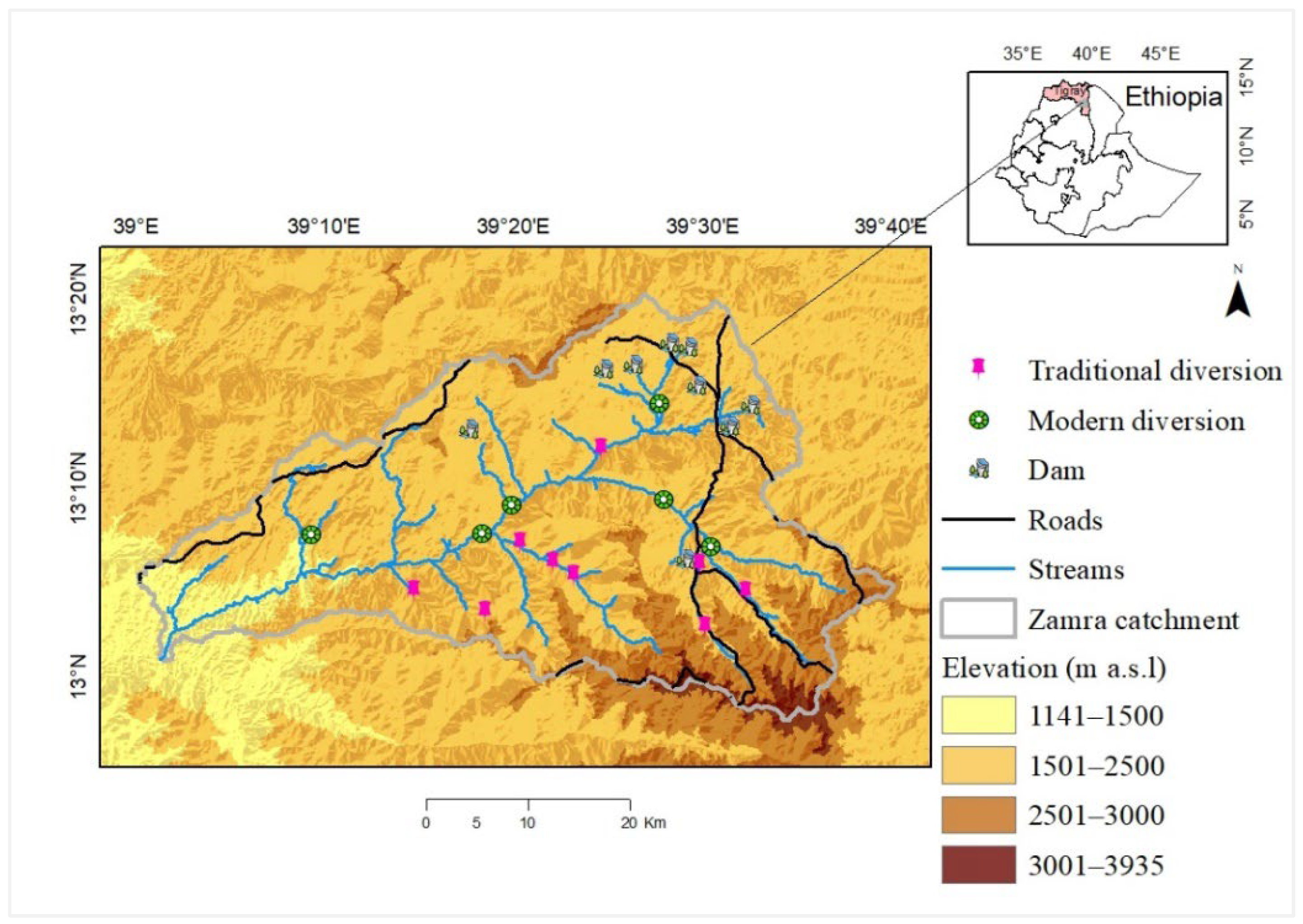
2.1. Study Area
2.2. Dataset
2.2.1. Field Survey
2.2.2. Remotely Sensed Data
3. Methodology
3.1. Use of Expert Knowledge
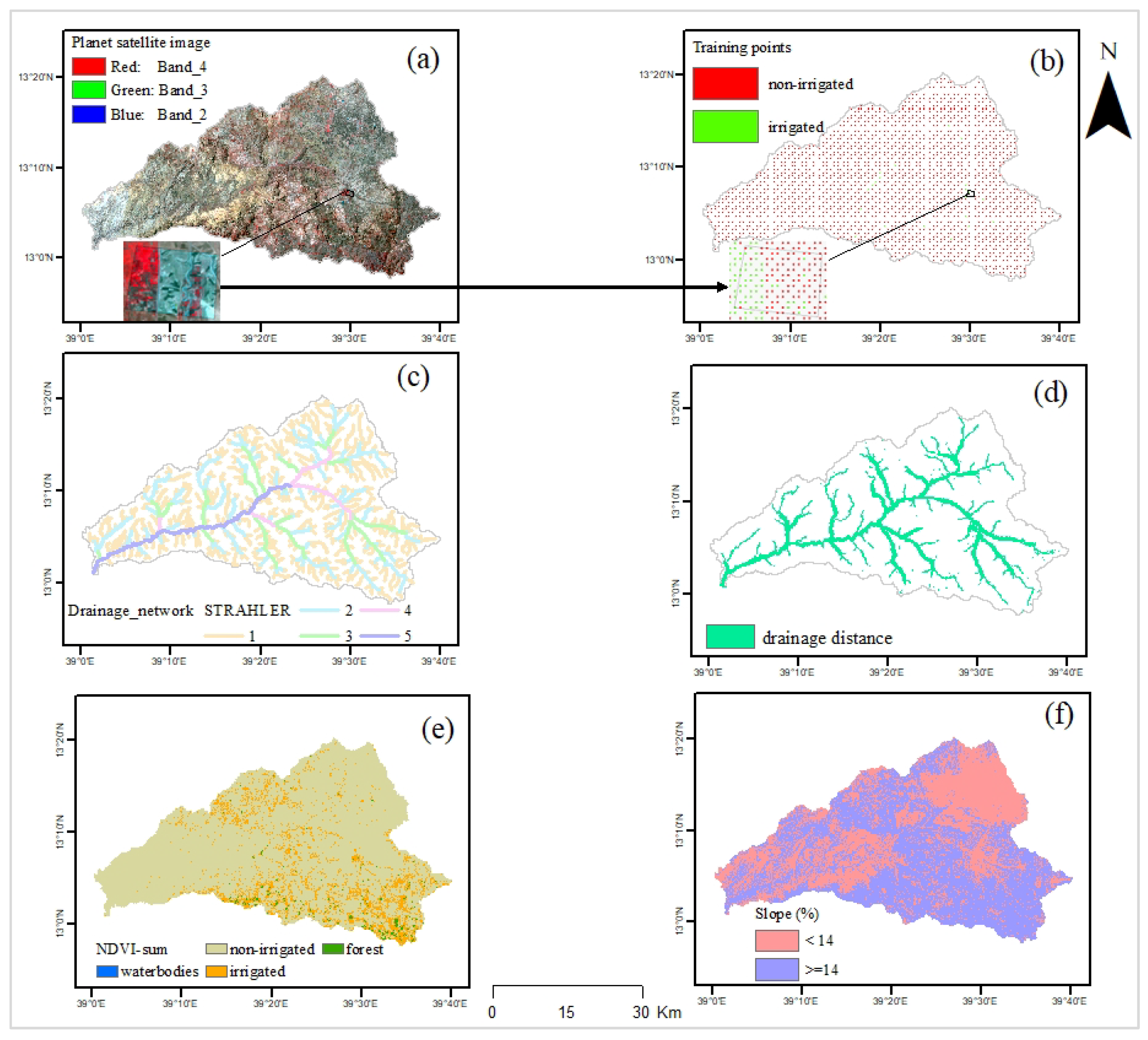
- First, the hydrological flow was determined; procedures followed included the calculation of a hydrologically consistent elevation model by the removal of sinks, flow direction, and flow accumulation.
- Second, the calculation of variable thresholds map to enable multiple flow accumulation thresholds was used in the drainage network extraction operation as the terrain consists of relatively flat plateau remnants (having larger flow accumulation thresholds) and steep escarpment with V-shaped valley floors (having lower flow accumulation thresholds) as well as broad U-shaped valleys (intermediate flow accumulation thresholds).
- Extract the drainage network (see Figure A1c) and conduct a drainage network ordering an operation to derive a full topological description of the network extracted.
3.2. Create a Sample Set
3.3. Random Forest Classifier
3.4. Validation
3.5. Classify Types of Irrigation Schemes
3.6. Sensitivity Analysis
4. Results
4.1. Expert and Other Decision Rules
4.2. Feature Importance Scores
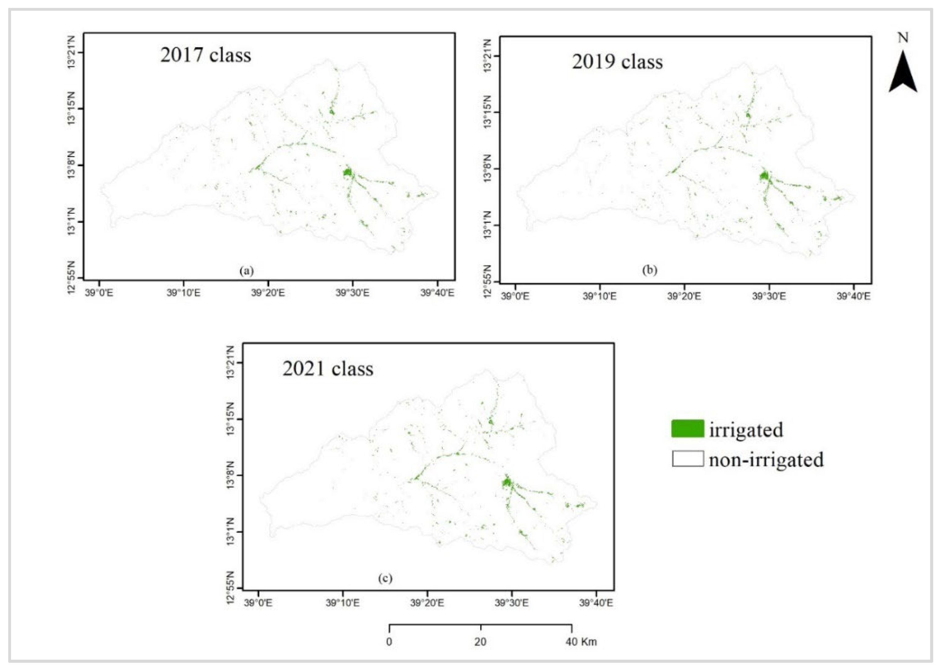
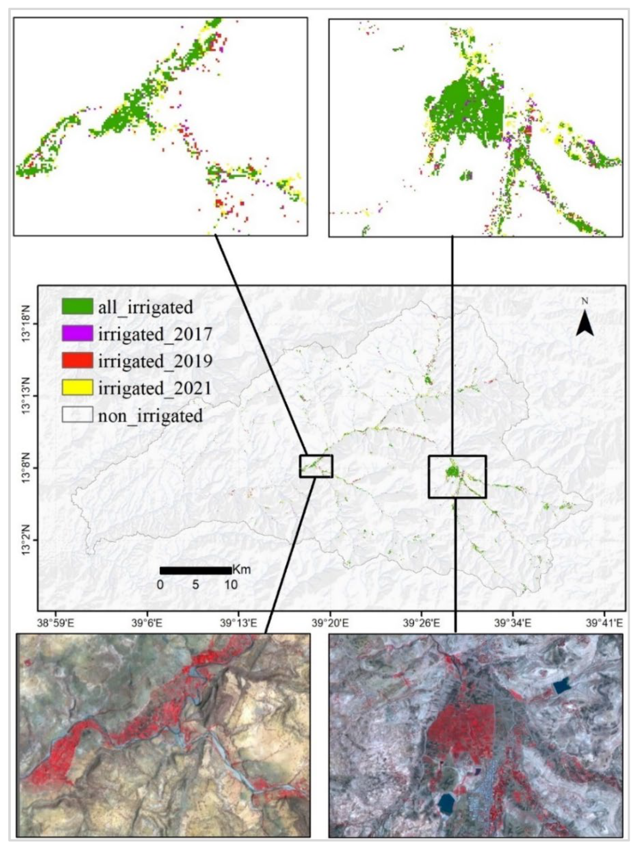
4.3. Irrigated Area Classification
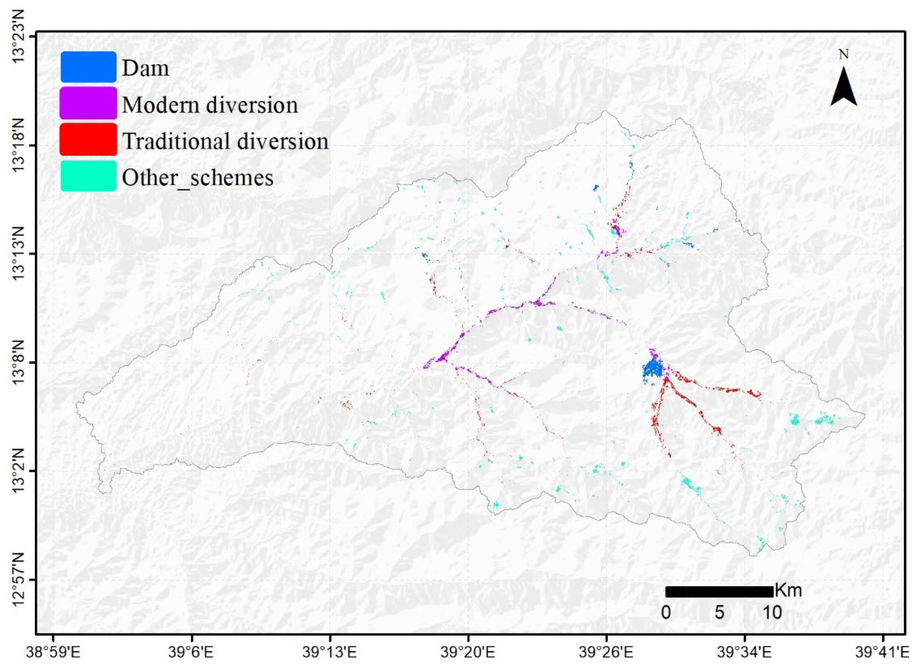
4.4. Characterize Irrigation Scheme Types
4.5. Evaluation of Irrigation Schemes
5. Discussion
5.1. Using Expert Knowledge
5.2. Random Forest Classifier
5.3. High-Resolution Multispectral Satellite Images
6. Conclusions
Author Contributions
Funding
Data Availability Statement
Conflicts of Interest
Appendix A
References
- National Planning Commission, Federal Democratic Republic of Ethiopia. Federal Democratic Republic of Ethiopia Growth and Transformation Plan II (GTP II); National Planning Commission, Federal Democratic Republic of Ethiopia: Addis Ababa, Ethiopia, 2016. [Google Scholar]
- Awulachew, S.; Erkossa, T.; Namara, R.E. Irrigation Potential in Ethiopia: Constraints and Opportunities for Enhancing the System; F1000Research; International Water Management Institute: Colombo, Sri Lanka, 2010. [Google Scholar]
- Hagos, E. Development and Management of Irrigation Lands in Tigray, Ethiopia. Ph.D Thesis, Wageningen University, Delft, The Netherlands, 2005; pp. 1–12. [Google Scholar]
- Teka, D.; van Wesemael, B.; Vanacker, V.; Poesen, J.; Hallet, V.; Taye, G.; Deckers, J.; Haregeweyn, N. Evaluating the Performance of Reservoirs in Semi-Arid Catchments of Tigray: Tradeoff between Water Harvesting and Soil and Water Conservation. Catena 2013, 110, 146–154. [Google Scholar] [CrossRef]
- Yohannes, D.F.; Ritsema, C.J.; Solomon, H.; Froebrich, J.; van Dam, J.C. Irrigation Water Management: Farmers’ Practices, Perceptions and Adaptations at Gumselassa Irrigation Scheme, North Ethiopia. Agric. Water Manag. 2017, 191, 16–28. [Google Scholar] [CrossRef]
- Behailu, M.; Haile, M. Water Harvesting in Northern Ethiopia: Environmental, Health and Socio-Economic Impacts | Mendeley. Available online: https://www.mendeley.com/search/?page=1&query=Water%20harvesting%20in%20northern%20Ethiopia%3A%20environmental%2C%20health%20and%20socio-economic%20impacts&sortBy=relevance (accessed on 10 December 2022).
- Haregeweyn, N.; Poesen, J.; Nyssen, J.; de Wit, J.; Haile, M.; Govers, G.; Deckers, S. Reservoirs in Tigray (Northern Ethiopia): Characteristics and Sediment Deposition Problems. Land Degrad. Dev. 2006, 17, 211–230. [Google Scholar] [CrossRef]
- Teka, D. Multi-Scale Analysis of Surface Runoff and Water-Harvesting Dams in a Semi-Arid Region: A Case Study in Tigray (Ethiopia). Ph.D. Thesis, UCL—Université Catholique de Louvain, Ottignies-Louvain-la-Neuve, Belgium, 2014. [Google Scholar]
- Yami, M. Sustaining Participation in Irrigation Systems of Ethiopia: What Have We Learned about Water User Associations? Water Policy 2013, 15, 961–984. [Google Scholar] [CrossRef]
- Gebrehiwot Yihdego, A. The Impact of Small—Scale Irrigation on Income of Rural Farm Households: Evidence from Ahferom Woreda in Tigray, Ethiopia. Int. J. Bus. Econ. Res. 2015, 4, 217–228. [Google Scholar] [CrossRef]
- Segers, K.; Dessein, J.; Nyssen, J.; Haile, M.; Deckers, J. Developers and Farmers Intertwining Interventions: The Case of Rainwater Harvesting and Food-for-Work in Degua Temben, Tigray, Ethiopia. J. Agric. Sustain. 2011, 6, 173–182. [Google Scholar] [CrossRef]
- Meaza, H.; Demissie, B.; Hermans, L.; Haftu, B.; Biruk, B.; Poesen, J.; Gebreyohannes Asfaha, T.; Zenebe, A.; Nyssen, J. Spatial and Seasonal Water Level Dynamics in Dryland Grabens along the Rift Valley of Northern Ethiopia. Hydrol. Sci. J. 2022, 67, 1418–1438. [Google Scholar] [CrossRef]
- Xiang, K.; Ma, M.; Liu, W.; Dong, J.; Zhu, X.; Yuan, W. Mapping Irrigated Areas of Northeast China in Comparison to Natural Vegetation. Remote Sens. 2019, 11, 825. [Google Scholar] [CrossRef]
- Guermazi, E.; Bouaziz, M.; Zairi, M. Water Irrigation Management Using Remote Sensing Techniques: A Case Study in Central Tunisia. Environ. Earth Sci. 2016, 75, 202. [Google Scholar] [CrossRef]
- Benbahria, Z.; Sebari, İ.; Hajji, H.; Smiej, M.F. Intelligent mapping of irrigated areas from landsat 8 images using transfer learning. Int. J. Eng. Geosci. 2021, 6, 40–50. [Google Scholar] [CrossRef]
- Abera, A.; Verhoest, N.E.C.; Tilahun, S.; Inyang, H.; Nyssen, J. Assessment of Irrigation Expansion and Implications for Water Resources by Using RS and GIS Techniques in the Lake Tana Basin of Ethiopia. Environ. Monit. Assess. 2020, 193, 13. [Google Scholar] [CrossRef] [PubMed]
- Velpuri, N.; Thenkabail, P.; Gumma, M.; Biradar, C.; Dheeravath, V.; Noojipady, P.; Yuanjie, L. Influence of Resolution in Irrigated Area Mapping and Area Estimation. Photogramm. Eng. Remote Sens. 2009, 75, 1383–1395. [Google Scholar] [CrossRef]
- Gumma, M.K.; Thenkabail, P.S.; Hideto, F.; Nelson, A.; Dheeravath, V.; Busia, D.; Rala, A. Mapping Irrigated Areas of Ghana Using Fusion of 30 m and 250 m Resolution Remote-Sensing Data. Remote Sens. 2011, 3, 816–835. [Google Scholar] [CrossRef]
- Chandrasekharan, K.M.; Subasinghe, C.; Haileslassie, A. Mapping Irrigated and Rainfed Agriculture in Ethiopia (2015–2016) Using Remote Sensing Methods; International Water Management Institute (IWMI): Colombo, Sri Lanka, 2021. [Google Scholar]
- WaPOR. FAO’s Portal to Monitor Water Productivity through Open Access of Remotely Sensed Derived Data. Available online: https://wapor.apps.fao.org/home/WAPOR_2/1 (accessed on 10 December 2022).
- FAOP Water Productivity. Available online: https://data.apps.fao.org/catalog/organization/wapor (accessed on 6 October 2022).
- Huang, Z.; Jia, X. Integrating Remotely Sensed Data, GIS and Expert Knowledge to Update Object-Based Land Use/Land Cover Information. Int. J. Remote Sens. 2012, 33, 905–921. [Google Scholar] [CrossRef]
- Zhu, A.X.; Wang, R.; Qiao, J.; Qin, C.Z.; Chen, Y.; Liu, J.; Du, F.; Lin, Y.; Zhu, T. An Expert Knowledge-Based Approach to Landslide Susceptibility Mapping Using GIS and Fuzzy Logic. Geomorphology 2014, 214, 128–138. [Google Scholar] [CrossRef]
- Yathish, H.; Athira, K.V.; Preethi, K.; Pruthviraj, U.; Shetty, A. A Comparative Analysis of Forest Fire Risk Zone Mapping Methods with Expert Knowledge. J. Indian Soc. Remote Sens. 2019, 47, 2047–2060. [Google Scholar] [CrossRef]
- Harou, I.L.; Whitney, C.; Kung’u, J.; Luedeling, E. Mapping Flood-Based Farming Systems with Bayesian Networks. Land 2020, 9, 369. [Google Scholar] [CrossRef]
- Song, J.H.; Her, Y.; Kang, M.S. Estimating Reservoir Inflow and Outflow From Water Level Observations Using Expert Knowledge: Dealing With an Ill-Posed Water Balance Equation in Reservoir Management. Water Resour. Res. 2022, 58, e2020WR028183. [Google Scholar] [CrossRef]
- Antonetti, M.; Zappa, M. How Can Expert Knowledge Increase the Realism of Conceptual Hydrological Models? A Case Study in the Swiss Pre-Alps. Hydrol. Earth Syst. Sci. 2018, 22, 4425–4447. [Google Scholar] [CrossRef]
- Nigussie, E.; Olwal, T.; Musumba, G.; Tegegne, T.; Lemma, A.; Mekuria, F. IoT-Based Irrigation Management for Smallholder Farmers in Rural Sub-Saharan Africa. Procedia Comput. Sci. 2020, 177, 86–93. [Google Scholar] [CrossRef]
- Merot, A.; Bergez, J.E. IRRIGATE: A Dynamic Integrated Model Combining a Knowledge-Based Model and Mechanistic Biophysical Models for Border Irrigation Management. Environ. Model. Softw. 2010, 25, 421–432. [Google Scholar] [CrossRef]
- Safavi, H.R.; Golmohammadi, M.H.; Sandoval-Solis, S. Expert Knowledge Based Modeling for Integrated Water Resources Planning and Management in the Zayandehrud River Basin. J. Hydrol. 2015, 528, 773–789. [Google Scholar] [CrossRef]
- Hrachowitz, M.; Fovet, O.; Ruiz, L.; Euser, T.; Gharari, S.; Nijzink, R.; Freer, J.; Savenije, H.H.G.; Gascuel-Odoux, C. Process Consistency in Models: The Importance of System Signatures, Expert Knowledge, and Process Complexity. Water Resour. Res. 2014, 50, 7445–7469. [Google Scholar] [CrossRef]
- Rahman, M.R.; Shi, Z.H.; Chongfa, C. Assessing Regional Environmental Quality by Integrated Use of Remote Sensing, GIS, and Spatial Multi-Criteria Evaluation for Prioritization of Environmental Restoration. Environ. Monit. Assess. 2014, 186, 6993–7009. [Google Scholar] [CrossRef]
- Grêt-Regamey, A.; Brunner, S.H.; Altwegg, J.; Christen, M.; Bebi, P. Integrating Expert Knowledge into Mapping Ecosystem Services Tradeoffs for Sustainable Forest Management. Ecol. Soc. 2013, 18, 34. [Google Scholar] [CrossRef]
- Zhong, L.; Hu, L.; Yu, L.; Gong, P.; Biging, G.S. Automated Mapping of Soybean and Corn Using Phenology. ISPRS J. Photogramm. Remote Sens. 2016, 119, 151–164. [Google Scholar] [CrossRef]
- Tang, K.; Zhu, W.; Zhan, P.; Ding, S. An Identification Method for Spring Maize in Northeast China Based on Spectral and Phenological Features. Remote Sens. 2018, 10, 193. [Google Scholar] [CrossRef]
- Ataklti, Y.T. Assessing the Potential of Geonetcast Earth Observation and In Situ Data for Drought Early Warning and Monitoring in Tigray, Ethiopia. Master’s Thesis, University of Twente, Enschede, The Netherlands, 2012. [Google Scholar]
- Behailu, M.; Nata, T. Monitoring Productivity of Water in Agriculture and Interacting Systems: The Case of Tekeze/Atbara River Basin in Ethiopia. In Proceedings of the East Africa Integrated River Basin Management, Morogoro, Tanzania, 7–9 March 2005. International Water Management Institute Conference Papers (No. h037543). [Google Scholar]
- Planet Team. Planet Application Program Interface: In space for life on Earth; Planet Team: San Francisco, CA, USA, 2017. [Google Scholar]
- Marta, S. Planet Imagery Product Specifications; Planet Labs: San Francisco, CA, USA, 2018. [Google Scholar]
- Roy, D.P.; Huang, H.; Houborg, R.; Martins, V.S. A Global Analysis of the Temporal Availability of PlanetScope High Spatial Resolution Multi-Spectral Imagery. Remote Sens. Environ. 2021, 264, 112586. [Google Scholar] [CrossRef]
- Norway’s International Climate and Forests Initiative (NICFI). Planet NICFI DATA Program User Guide Third-Party Participants (Level 1 Users); Norway’s International Climate and Forests Initiative (NICFI): Oslo, Norway, 2021. [Google Scholar]
- O’Shea, T. NICFI Tropical Forest Basemaps now Available in Google Earth Engine. Available online: https://www.planet.com/pulse/nicfi-tropical-forest-basemaps-now-available-in-google-earth-engine/ (accessed on 6 October 2022).
- Airbus Defence and Space GmbH. Copernicus DEM Copernicus Digital Elevation Model Product Handbook; GEO.2018-1988-2; Airbus Defence and Space GmbH: Taufkirchen, Germany, 2020. [Google Scholar]
- Wilson, J.P.; Gallant, J.C. Digital Terrain Analysis. In Terrain Analysis: Principles and Applications; John Wiley & Sons: New York, NY, USA, 2000. [Google Scholar]
- Lohani, S.; Baffaut, C.; Thompson, A.L.; Aryal, N.; Bingner, R.L.; Bjorneberg, D.L.; Bosch, D.D.; Bryant, R.B.; Buda, A.; Dabney, S.M.; et al. Performance of the Soil Vulnerability Index with Respect to Slope, Digital Elevation Model Resolution, and Hydrologic Soil Group. J. Soil Water Conserv. 2020, 75, 12–27. [Google Scholar] [CrossRef]
- Manzurul Hassan, M.; Ashraf Ali, M.; Hassan, M.M.; Ali, M.A. Digital Elevation Model and Irrigation Management Planning in Bangladesh. In Livelihood Enhancement through Agriculture, Tourism and Health; Springer: Singapore, 2022; pp. 111–135. [Google Scholar] [CrossRef]
- Bashir, N.; Saeed, R.; Afzaal, M.; Ahmad, A.; Muhammad, N.; Iqbal, J.; Khan, A.; Maqbool, Y.; Hameed, S. Water Quality Assessment of Lower Jhelum Canal in Pakistan by Using Geographic Information System (GIS). Groundw. Sustain. Dev. 2020, 10, 100357. [Google Scholar] [CrossRef]
- Clavel, L.; Soudais, J.; Baudet, D.; Leenhardt, D. Integrating Expert Knowledge and Quantitative Information for Mapping Cropping Systems. Land Use Policy 2011, 28, 57–65. [Google Scholar] [CrossRef]
- Ge, Y.; Zhang, X.; Atkinson, P.M.; Stein, A.; Li, L. Geoscience-Aware Deep Learning: A New Paradigm for Remote Sensing. Sci. Remote Sens. 2022, 5, 100047. [Google Scholar] [CrossRef]
- Ghorbani, A.; Mossivand, A.M.; Ouri, A.E. Utility of the NDVI for Land/Canopy Cover Mapping in Khalkhal County (Iran). Ann. Biol. Res. 2012, 3, 5494–5503. [Google Scholar]
- Demissie, B.; Nyssen, J.; Annys, S.; Negash, E.; Gebrehiwet, T.; Abay, F.; Wolff, E. Geospatial Solutions for Evaluating the Impact of the Tigray Conflict on Farming. Acta Geophys. 2022, 70, 1285–1299. [Google Scholar] [CrossRef]
- Oldoni, L.V.; Cattani, C.E.V.; Mercante, E.; Johann, J.A.; Antunes, J.F.G.; Almeida, L. Annual Cropland Mapping Using Data Mining and OLI Landsat-8. Rev. Bras. Eng. Agríc. Ambient. 2019, 23, 952–958. [Google Scholar] [CrossRef]
- Magidi, J.; Nhamo, L.; Mpandeli, S.; Mabhaudhi, T. Application of the Random Forest Classifier to Map Irrigated Areas Using Google Earth Engine. Remote Sens. 2021, 13, 876. [Google Scholar] [CrossRef]
- Vogels, M.F.A.; de Jong, S.M.; Sterk, G.; Addink, E.A. Mapping Irrigated Agriculture in Complex Landscapes Using SPOT6 Imagery and Object-Based Image Analysis—A Case Study in the Central Rift Valley, Ethiopia. Int. J. Appl. Earth Obs. Geoinf. 2019, 75, 118–129. [Google Scholar] [CrossRef]
- Mirasi, A.; Mahmoudi, A.; Navid, H.; Valizadeh Kamran, K.; Asoodar, M.A. Evaluation of Sum-NDVI Values to Estimate Wheat Grain Yields Using Multi-Temporal Landsat OLI Data. Geocarto Int. 2021, 36, 1309–1324. [Google Scholar] [CrossRef]
- Scherler, D.; Schwanghart, W. Drainage Divide Networks—Part 1: Identification and Ordering in Digital Elevation Models. Earth Surf. Dyn. 2020, 8, 245–259. [Google Scholar] [CrossRef]
- Pradhan, M.P.; Ghose, M.K.; Kharka, Y.R. Automatic Association of Strahler’s Order and Attributes with the Drainage System. Int. J. Adv. Comput. Sci. Appl. 2012, 3. [Google Scholar] [CrossRef]
- Lindsay, J.B.; Yang, W.; Hornby, D.D. Drainage Network Analysis and Structuring of Topologically Noisy Vector Stream Data. ISPRS Int. J. Geo-Inf. 2019, 8, 422. [Google Scholar] [CrossRef]
- Breiman, L. Random Forests. Mach. Learn. 2001, 45, 5–32. [Google Scholar] [CrossRef]
- Belgiu, M.; Drăgu, L. Random Forest in Remote Sensing: A Review of Applications and Future Directions. ISPRS J. Photogramm. Remote Sens. 2016, 114, 24–31. [Google Scholar] [CrossRef]
- Oliphant, A.J.; Thenkabail, P.S.; Teluguntla, P.; Xiong, J.; Gumma, M.K.; Congalton, R.G.; Yadav, K. Mapping Cropland Extent of Southeast and Northeast Asia Using Multi-Year Time-Series Landsat 30-m Data Using a Random Forest Classifier on the Google Earth Engine Cloud. Int. J. Appl. Earth Obs. Geoinf. 2019, 81, 110–124. [Google Scholar] [CrossRef]
- Gislason, P.O.; Benediktsson, J.A.; Sveinsson, J.R. Random Forests for Land Cover Classification. Pattern Recognit. Lett. 2006, 27, 294–300. [Google Scholar] [CrossRef]
- Corcoran, J.M.; Knight, J.F.; Gallant, A.L. Influence of Multi-Source and Multi-Temporal Remotely Sensed and Ancillary Data on the Accuracy of Random Forest Classification of Wetlands in Northern Minnesota. Remote Sens. 2013, 5, 3212–3238. [Google Scholar] [CrossRef]
- Liu, C.; Li, J.; Tang, Q.; Qi, J.; Zhou, X. Classifying the Nunivak Island Coastline Using the Random Forest Integration of the Sentinel-2 and ICESat-2 Data. Land 2022, 11, 240. [Google Scholar] [CrossRef]
- Ghosh, A.; Sharma, R.; Joshi, P.K. Random Forest Classification of Urban Landscape Using Landsat Archive and Ancillary Data: Combining Seasonal Maps with Decision Level Fusion. Appl. Geogr. 2014, 48, 31–41. [Google Scholar] [CrossRef]
- Richard, K.; Abdel-Rahman, E.M.; Subramanian, S.; Nyasani, J.O.; Thiel, M.; Jozani, H.; Borgemeister, C.; Landmann, T. Maize Cropping Systems Mapping Using RapidEye Observations in Agro-Ecological Landscapes in Kenya. Sensors 2017, 17, 2537. [Google Scholar] [CrossRef]
- Wellington, M.J.; Renzullo, L.J. High-Dimensional Satellite Image Compositing and Statistics for Enhanced Irrigated Crop Mapping. Remote Sens. 2021, 13, 1300. [Google Scholar] [CrossRef]
- Rangecroft, S.; Van Loon, A.F.; Maureira, H.; Verbist, K.; Hannah, D.M. An Observation-Based Method to Quantify the Human Influence on Hydrological Drought: Upstream–Downstream Comparison. Hydrol. Sci. J. 2019, 64, 276–287. [Google Scholar] [CrossRef]
- Boulton, S.J.; Stokes, M. Which DEM Is Best for Analyzing Fluvial Landscape Development in Mountainous Terrains? Geomorphology 2018, 310, 168–187. [Google Scholar] [CrossRef]
- Oh, H.J.; Kadavi, P.R.; Lee, C.W.; Lee, S. Evaluation of Landslide Susceptibility Mapping by Evidential Belief Function, Logistic Regression and Support Vector Machine Models. Geomat. Nat. Hazards Risk 2018, 9, 1053–1070. [Google Scholar] [CrossRef]
- Embaye, T.A.G.; Kahsay, G.H.; Abadi, N.; Kebede, M.M.; Dessie, D.T. Evaluation of Water Harvesting Structures on Agricultural Productivity: The Case of Tigray Region, Ethiopia. Sustain. Water Resour. Manag. 2020, 6, 78. [Google Scholar] [CrossRef]
- Bharatkar, P.S.; Patel, R. Approach to Accuracy Assessment Tor RS Image Classification Techniques. Int. J. Sci. Eng. Res. 2013, 4, 79–86. [Google Scholar]
- Ding, Y.; Zhao, K.; Zheng, X.; Jiang, T. Temporal Dynamics of Spatial Heterogeneity over Cropland Quantified by Time-Series NDVI, near Infrared and Red Reflectance of Landsat 8 OLI Imagery. Int. J. Appl. Earth Obs. Geoinf. 2014, 30, 139–145. [Google Scholar] [CrossRef]
- Zurqani, H.A.; Allen, J.S.; Post, C.J.; Pellett, C.A.; Walker, T.C. Mapping and Quantifying Agricultural Irrigation in Heterogeneous Landscapes Using Google Earth Engine. Remote Sens. Appl. 2021, 23, 100590. [Google Scholar] [CrossRef]


| Inputs | Set 1 | Set 2 | Set 3 | Difference |
|---|---|---|---|---|
| NDVI-sum | 1.6–2.5 | 1.55–2.55 | 1.65–2.45 | ±0.5 |
| Slope | <14% | <15% | <13% | ±1 |
| 2nd Strahler stream order | <150 m | <200 m | <100 m | ±50 |
| >2nd Strahler stream order | <375 m | <450 m | <300 m | ±75 |
| Larger irrigation areas | >7500 m2 | >6500 m2 | >8500 m2 | ±1000 |
| Area (ha) | Overall Accuracy | Kappa Coefficient | |||
|---|---|---|---|---|---|
| Irrigated | Non-Irrigated | Total | |||
| Set 1 | 2186 | 156,614 | 158,800 | 99.7% | 0.83 |
| Set 2 | 2867 | 155,933 | 158,800 | 99.3% | 0.66 |
| Set 3 | 1358 | 157,442 | 158,800 | 99.6% | 0.69 |
| OOB Prediction Accuracy | |||
|---|---|---|---|
| 2021 | 2019 | 2017 | |
| 99.7% | 99.6% | 99.5% | |
| Feature importance scores | |||
| 2021 | 2019 | 2017 | Inputs |
| Band 1: 0.097720 Band 2: 0.094821 Band 3: 0.173752 Band 4: 0.148481 | Band 1: 0.122368 Band 2: 0.108202 Band 3: 0.136867 Band 4: 0.148804 | Band 1: 0.107055 Band 2: 0.107688 Band 3: 0.142575 Band 4: 0.154438 | Multispectral bands B, G, R, and NIR |
| Band 5: 0.104408 | Band 5: 0.108395 | Band 5: 0.103076 | Drainage distance |
| Band 6: 0.197233 | Band 6: 0.185018 | Band 6: 0.188705 | Slope |
| Band 7: 0.000965 Band 8: 0.005317 Band 9: 0.009701 Band 10: 0.006618 Band 11: 0.014657 Band 12: 0.008834 Band 13: 0.026352 Band 14: 0.039734 Band 15: 0.055195 Band 16: 0.000325 Band 17: 0.000378 Band 18: 0.015498 | Band 7: 0.001137 Band 8: 0.004730 Band 9: 0.008809 Band 10: 0.005626 Band 11: 0.015232 Band 12: 0.011637 Band 13: 0.030945 Band 14: 0.040104 Band 15: 0.055367 Band 16: 0.000427 Band 17: 0.000383 Band 18: 0.015942 | Band 7: 0.001272 Band 8: 0.005488 Band 9: 0.010085 Band 10: 0.007057 Band 11: 0.015819 Band 12: 0.012766 Band 13: 0.031406 Band 14: 0.041370 Band 15: 0.054557 Band 16: 0.000368 Band 17: 0.000410 Band 18: 0.015855 | NICFI-NDVI monthly composite starting from September 2020 to August 2021 |
| Class | The Coverage Area for Each Year (Hectare) | ||
|---|---|---|---|
| 2017 | 2019 | 2021 | |
| Irrigated | 2078 | 2093 | 2186 |
| Non-irrigated | 156,722 | 156,707 | 156,614 |
| Total | 158,800 | 158,800 | 158,800 |
| Year | Overall Accuracy | Kappa Coefficient | Class | Non-Irrigated | Irrigated |
|---|---|---|---|---|---|
| 2017 | 99.6% | 0.71 | PA | 99.8% | 64% |
| UA | 99.7% | 81% | |||
| 2019 | 99.6% | 0.75 | PA | 99.8% | 68% |
| UA | 99.7% | 83% | |||
| 2021 | 99.7% | 0.83 | PA | 99.9% | 79% |
| UA | 99.8% | 87% |
| Scheme Types | Reference Totals | Classified Totals | Number Correct | Unclassified | Producer Accuracy | User Accuracy |
|---|---|---|---|---|---|---|
| Dam | 9 | 9 | 8 | 1 | 89% | 89% |
| Modern diversion | 6 | 7 | 5 | - | 71% | 83% |
| Traditional diversion | 9 | 9 | 6 | 1 | 67% | 67% |
| Other schemes | 30 | 25 | 24 | 2 | 96% | 80% |
| Total | 54 | 50 | 43 | 4 | ||
| Overall accuracy | 80% | |||||
| Kappa coefficient | 0.70 |
Disclaimer/Publisher’s Note: The statements, opinions and data contained in all publications are solely those of the individual author(s) and contributor(s) and not of MDPI and/or the editor(s). MDPI and/or the editor(s) disclaim responsibility for any injury to people or property resulting from any ideas, methods, instructions or products referred to in the content. |
© 2023 by the authors. Licensee MDPI, Basel, Switzerland. This article is an open access article distributed under the terms and conditions of the Creative Commons Attribution (CC BY) license (https://creativecommons.org/licenses/by/4.0/).
Share and Cite
Mohammedshum, A.A.; Maathuis, B.H.P.; Mannaerts, C.M.; Teka, D. Mapping Small-Scale Irrigation Areas Using Expert Decision Rules and the Random Forest Classifier in Northern Ethiopia. Remote Sens. 2023, 15, 5647. https://doi.org/10.3390/rs15245647
Mohammedshum AA, Maathuis BHP, Mannaerts CM, Teka D. Mapping Small-Scale Irrigation Areas Using Expert Decision Rules and the Random Forest Classifier in Northern Ethiopia. Remote Sensing. 2023; 15(24):5647. https://doi.org/10.3390/rs15245647
Chicago/Turabian StyleMohammedshum, Amina Abdelkadir, Ben H. P. Maathuis, Chris M. Mannaerts, and Daniel Teka. 2023. "Mapping Small-Scale Irrigation Areas Using Expert Decision Rules and the Random Forest Classifier in Northern Ethiopia" Remote Sensing 15, no. 24: 5647. https://doi.org/10.3390/rs15245647
APA StyleMohammedshum, A. A., Maathuis, B. H. P., Mannaerts, C. M., & Teka, D. (2023). Mapping Small-Scale Irrigation Areas Using Expert Decision Rules and the Random Forest Classifier in Northern Ethiopia. Remote Sensing, 15(24), 5647. https://doi.org/10.3390/rs15245647