


Mapping Grassland Based on Bio-Climate Probability and Intra-Annual Time-Series Abundance Data of Vegetation Habitats

Abstract
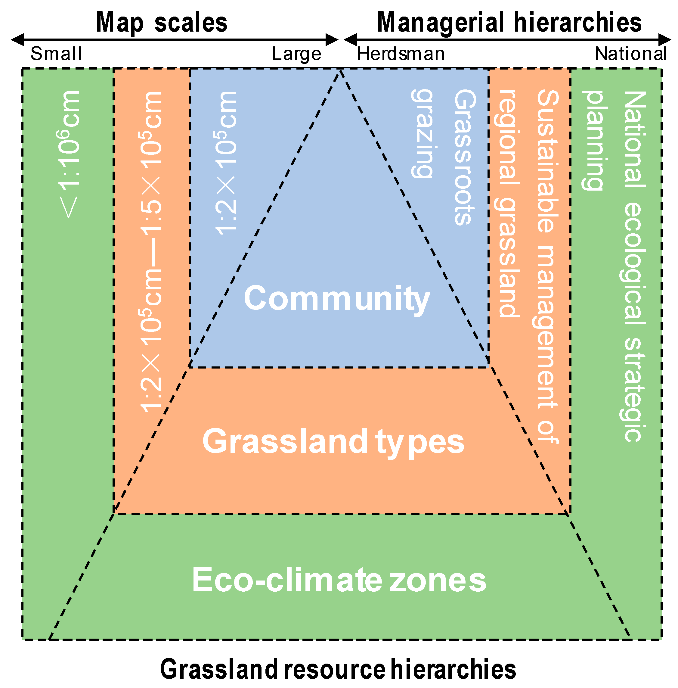
:1. Introduction
2. Materials and Methods
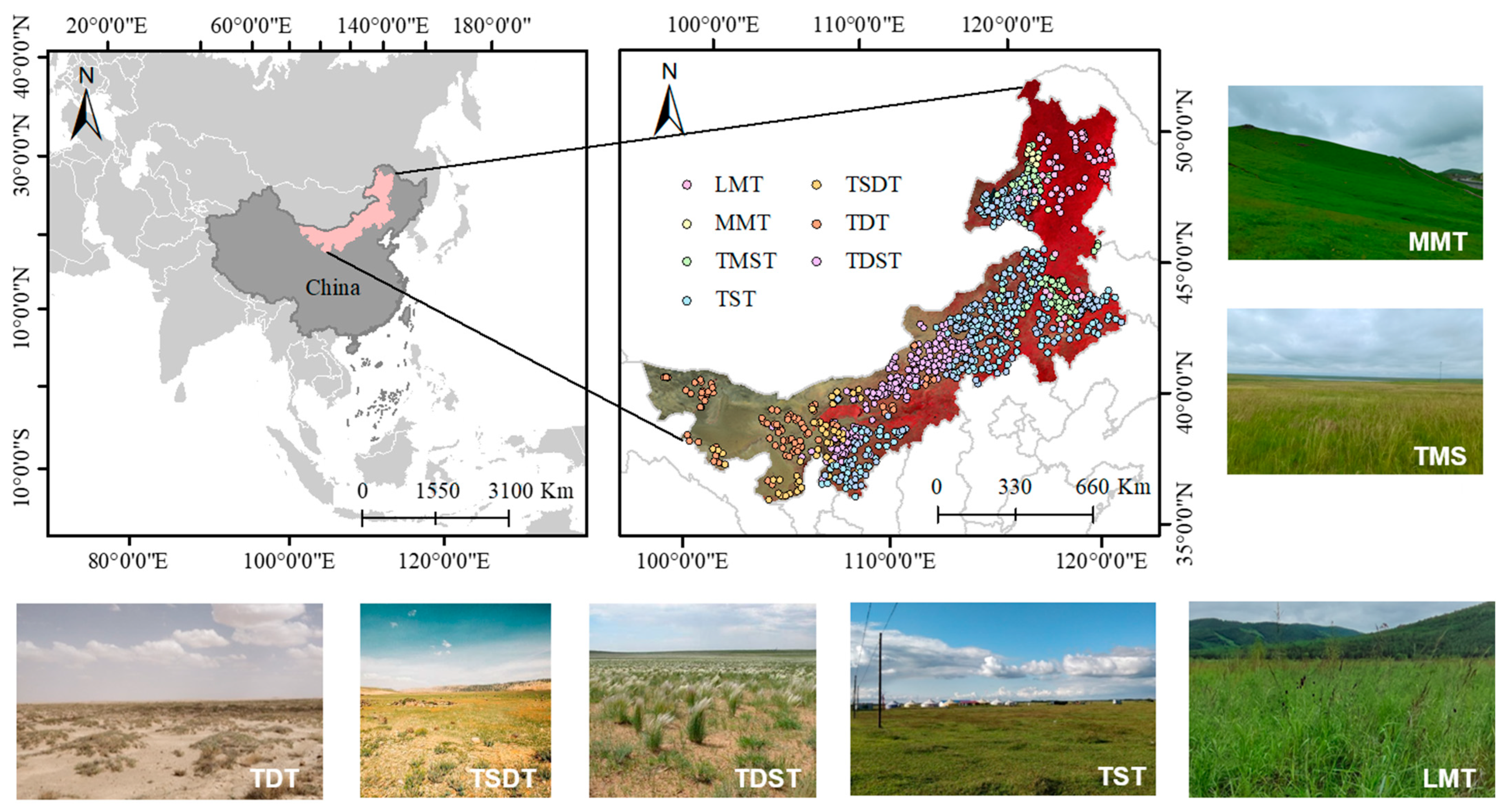
2.1. Study Area
2.2. Data Sources
2.2.1. Satellite Data
2.2.2. Field Sampling
2.3. Methods
2.3.1. Grassland Type Classification System
2.3.2. Grassland Bio-Climate Factors and Probability
2.3.3. Surface Spectral Endmember Space
2.3.4. Grassland Mapping in Inner Mongolia
3. Results
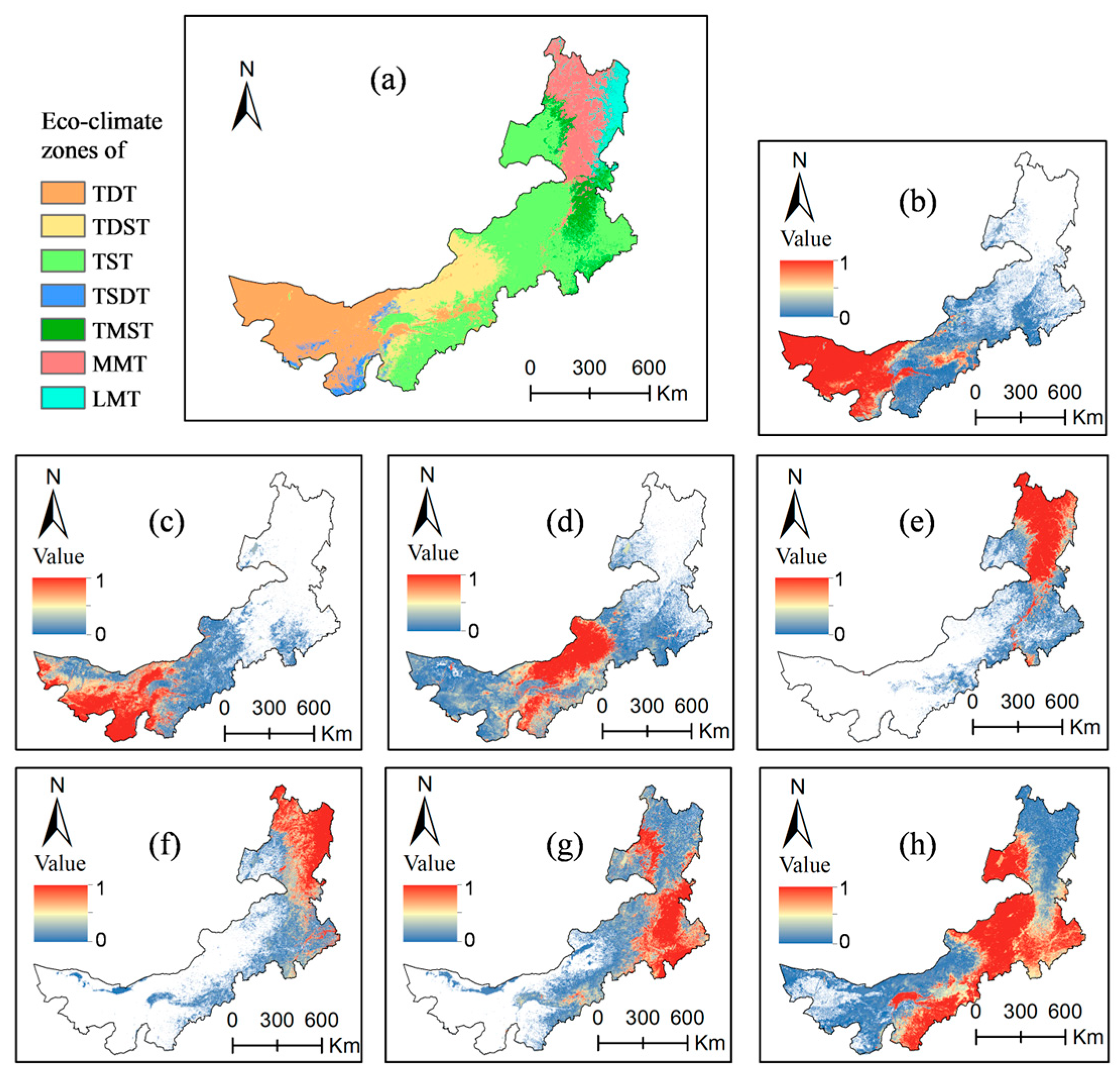
3.1. Grassland Bio-Climate Probability Maps and Grassland Bio-Climate Zoning
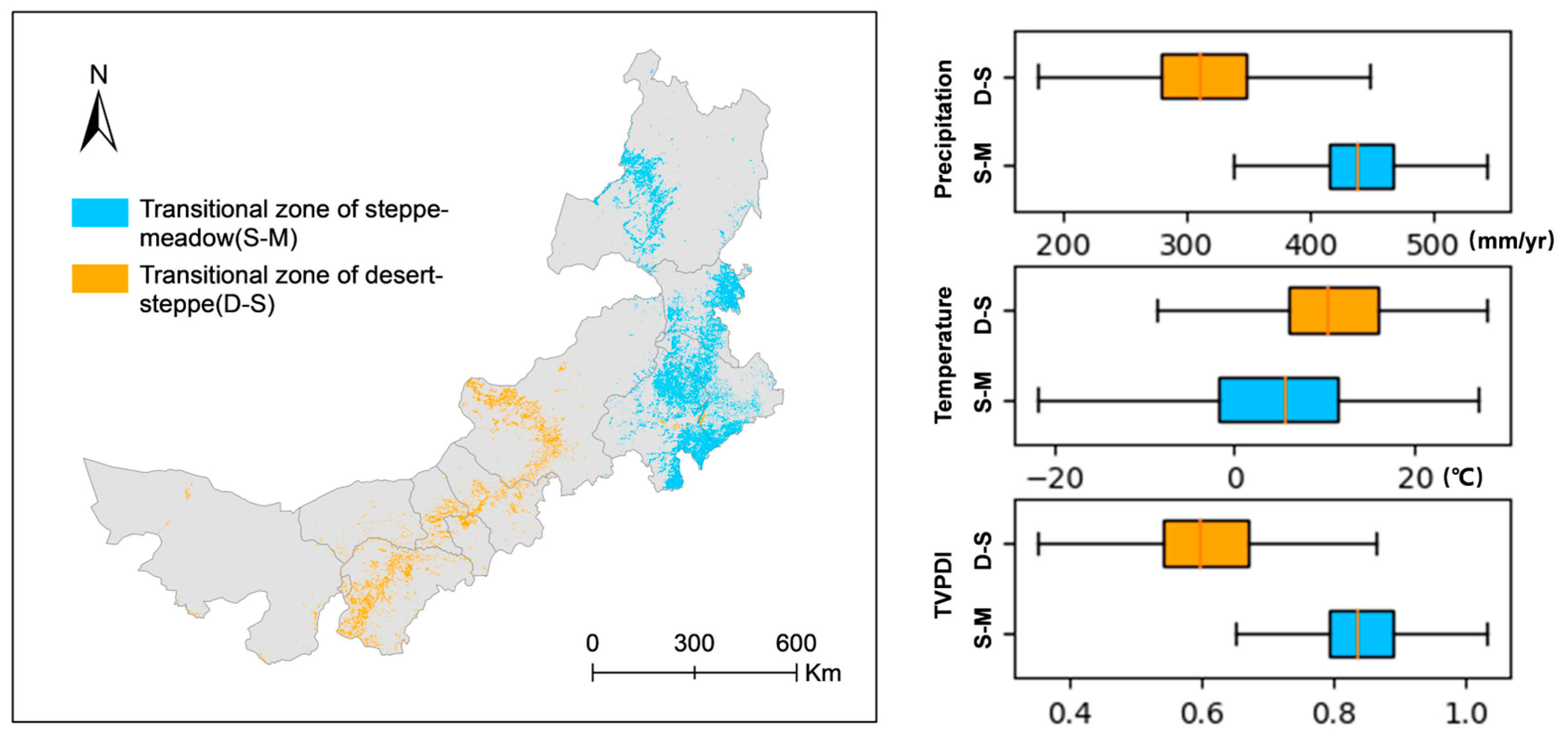
3.2. The critical Transition Zones of Latent Succession of Typical Grassland Types
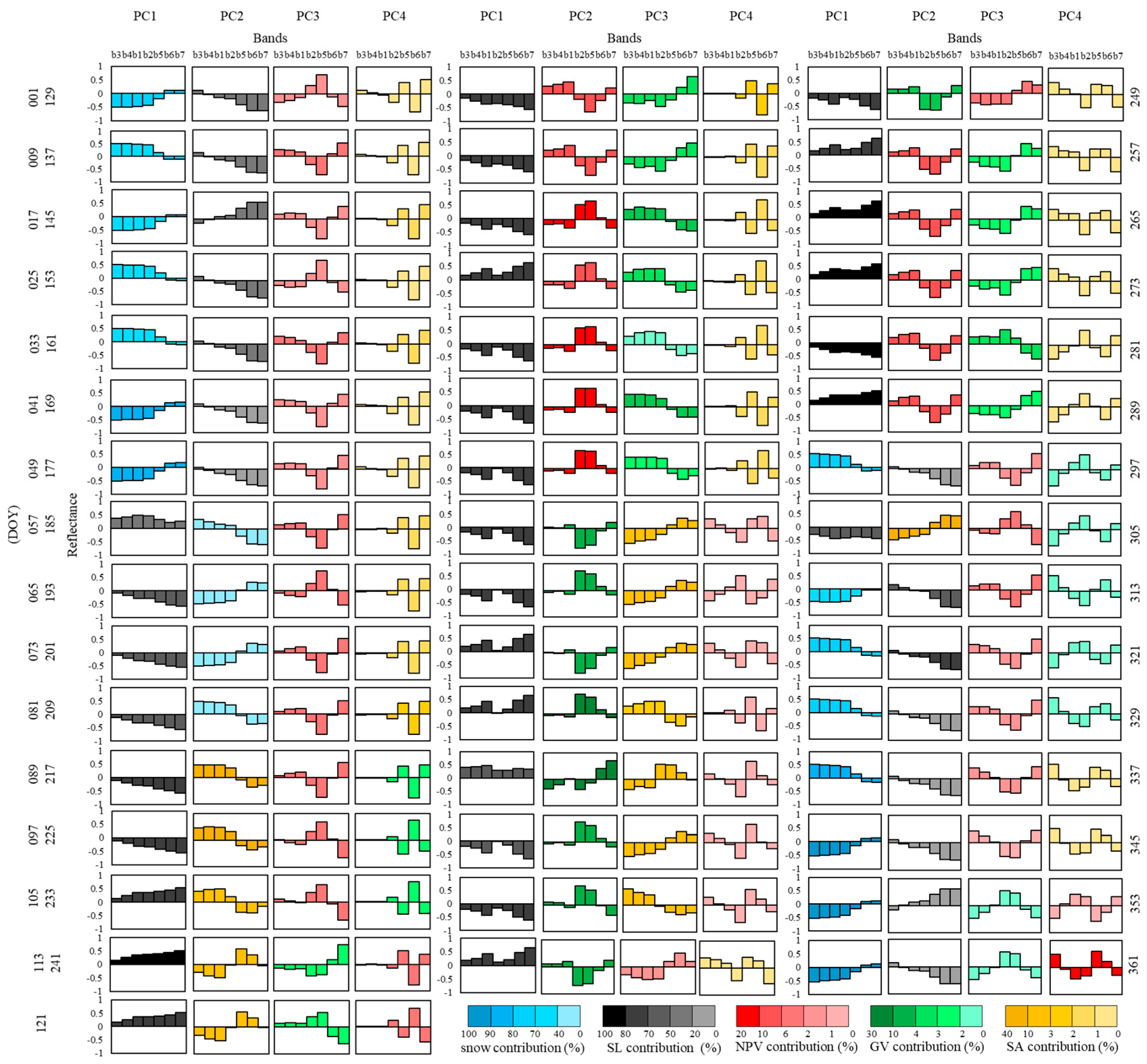
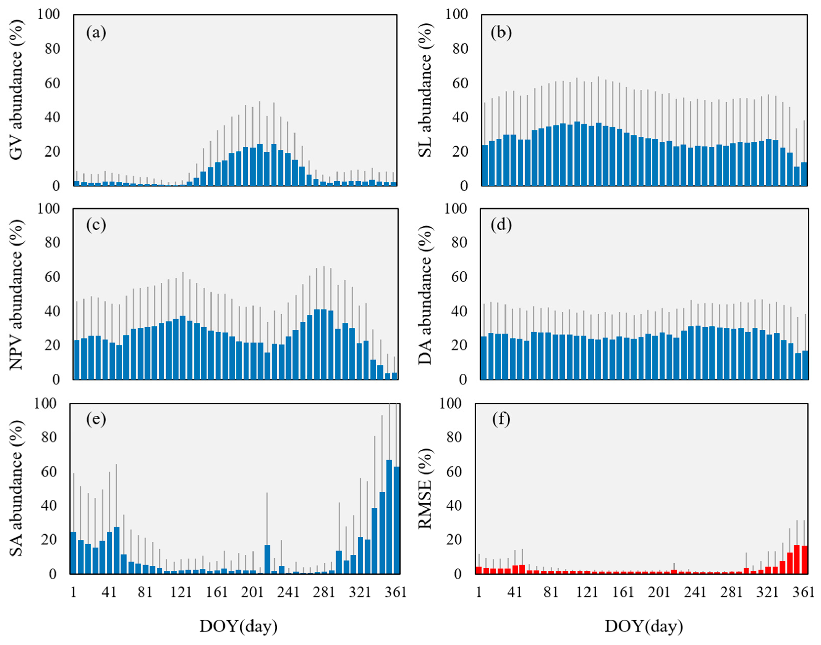
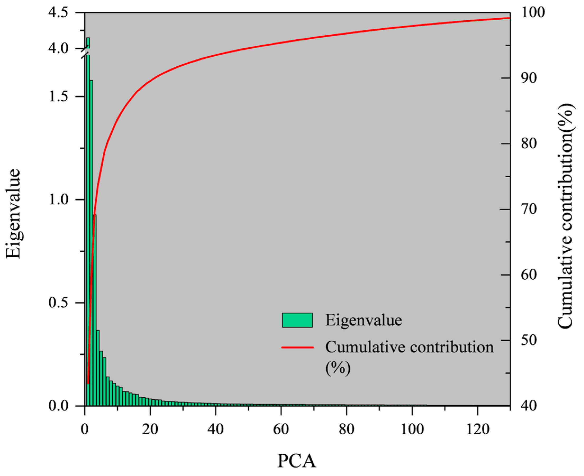
3.3. Spectral Unmixing Results and Stability Estimate
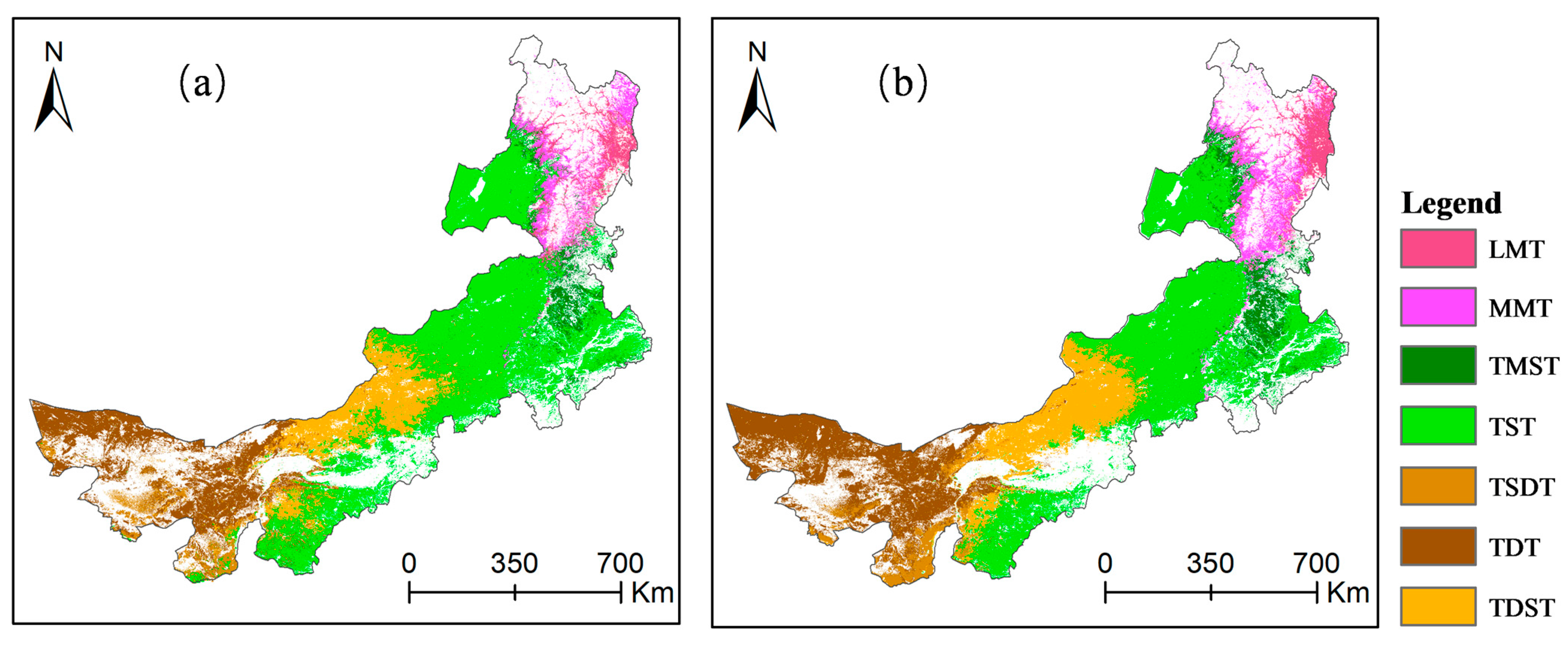
3.4. Accuracy Evaluation and Distribution of Grassland Types in Inner Mongolia
4. Discussion
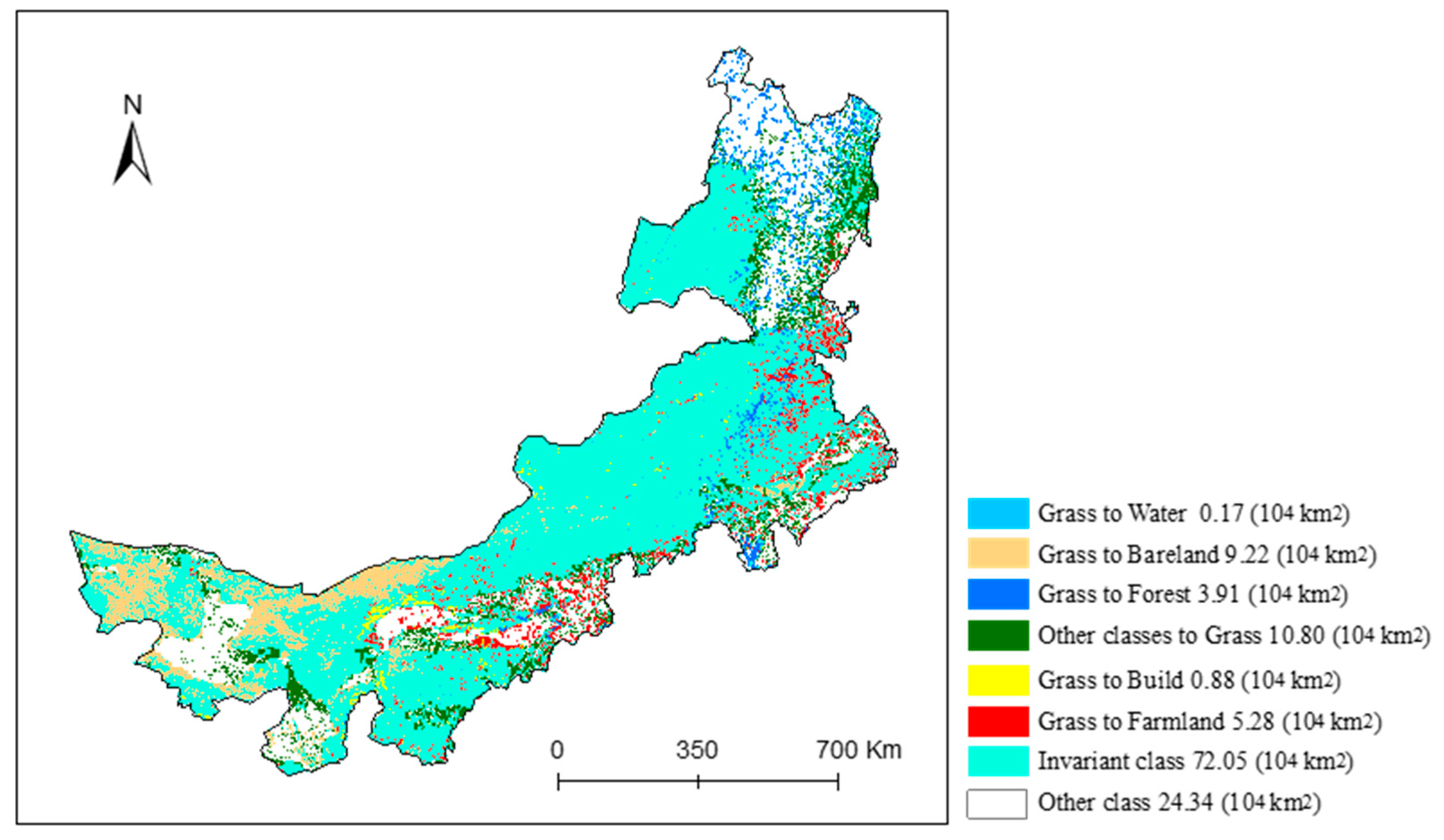
4.1. The Results and Pattern Evolution of Grassland Classification in Inner Mongolia
4.2. Limitations of Classification Using MOD09A1 Imageries and Future Prospects
4.3. Implications of the Experimental Framework with Bio-Climate Factors and SVD Space
5. Conclusions
Author Contributions
Funding
Institutional Review Board Statement
Informed Consent Statement
Data Availability Statement
Conflicts of Interest
References
- Li, Y.; Brando, P.M.; Morton, D.C.; Lawrence, D.M.; Yang, H.; Randerson, J.T. Deforestation-induced climate change reduces carbon storage in remaining tropical forests. Nat. Commun. 2022, 13, 1964. [Google Scholar] [CrossRef] [PubMed]
- Tiedje, J.M.; Bruns, M.A.; Casadevall, A.; Criddle, C.S.; Eloe-Fadrosh, E.; Karl, D.M.; Nguyen, N.K.; Zhou, J. Microbes and Climate Change: A Research Prospectus for the Future. Mbio 2022, 13, e0080022. [Google Scholar] [CrossRef] [PubMed]
- Chang, Y.; Choi, D.; Kim, H. Dynamic Trends of Carbon Intensities among 127 Countries. Sustainability 2017, 9, 2268. [Google Scholar] [CrossRef]
- Casey, J.W.; Holden, N.M. Analysis of greenhouse gas emissions from the average Irish milk production system. Agric. Syst. 2005, 86, 97–114. [Google Scholar] [CrossRef]
- John, W.; Nicholas, M. Holistic analysis of GHG emissions from Irish livestock production systems. In Proceedings of the 2005 ASAE Annual Meeting, American Society of Agricultural and Biological Engineers, Tampa, FL, USA, 17–20 July 2005. [Google Scholar]
- Chang, J.; Ciais, P.; Gasser, T.; Smith, P.; Herrero, M.; Havlík, P.; Obersteiner, M.; Guenet, B.; Goll, D.S.; Li, W. Climate warming from managed grasslands cancels the cooling effect of carbon sinks in sparsely grazed and natural grasslands. Nat. Commun. 2021, 12, 118. [Google Scholar] [CrossRef]
- Garnett, T.; Godde, C.; Muller, A.; Rs, E.; Zanten, H.V. Grazed and Confused? Ruminating on Cattle, Grazing Systems, Methane, Nitrous Oxide, the Soil Carbon Sequestration Question—And What It All Means for Greenhouse Gas Emissions; FCRN: London, UK, 2017. [Google Scholar]
- Suttie, J.M.; Reynolds, S.G.; Batello, C. Grasslands of the World; Food & Agriculture Org.: Rome, Italy, 2005. [Google Scholar]
- Li, C.; Fu, B.; Wang, S.; Stringer, L.C.; Wang, Y.; Li, Z.; Liu, Y.; Zhou, W. Drivers and impacts of changes in China’s drylands. Nat. Rev. Earth Environ. 2021, 2, 858–873. [Google Scholar] [CrossRef]
- Ze, H.; Wei, S.; Xiangzheng, D.; Xinliang, X. Grassland ecosystem responses to climate change and human activities within the Three-River Headwaters region of China. Sci. Rep. 2018, 8, 9079. [Google Scholar]
- Grekousis, G.; Mountrakis, G.; Kavouras, M. An overview of 21 global and 43 regional land-cover mapping products. Int. J. Remote Sens. 2015, 36, 5309–5335. [Google Scholar] [CrossRef]
- Smith, W.K.; Dannenberg, M.P.; Yan, D.; Herrmann, S.; Yang, J. Remote sensing of dryland ecosystem structure and function: Progress, challenges, and opportunities. Remote Sens. Environ. 2019, 233, 111401. [Google Scholar] [CrossRef]
- Chladil, M.A.; Nunez, M. Assessing Grassland Moisture and Biomass in Tasmania-the Application of Remote-Sensing and Empirical-Models for a Cloudy Environment. Int. J. Wildland Fire 1995, 5, 165–171. [Google Scholar] [CrossRef]
- McVicar, T.R.; Jupp, D.L. The current and potential operational uses of remote sensing to aid decisions on drought exceptional circumstances in Australia: A review. Agric. Syst. 1998, 57, 399–468. [Google Scholar] [CrossRef]
- Hazaymeh, K.; Hassan, Q.K. A remote sensing-based agricultural drought indicator and its implementation over a semi-arid region, Jordan. J. Arid Land 2017, 9, 319–330. [Google Scholar] [CrossRef]
- Belda, M.; Holtanová, E.; Halenka, T.; Kalvová, J. Climate classification revisited: From Köppen to Trewartha. Clim. Res. 2014, 59, 1–13. [Google Scholar] [CrossRef]
- Peel, M.C.; Finlayson, B.L.; Mcmahon, T.A. Updated World Map of the Koppen-Geiger Climate Classification. Hydrol. Earth Syst. Sci. 2007, 11, 1633–1644. [Google Scholar] [CrossRef]
- Jing, H.; Feng, Y.; Zhang, W.; Zhang, Y.; Chen, K. Effective Classification of Local Climate Zones Based on Multi-Source Remote Sensing Data. In Proceedings of the IGARSS 2019—2019 IEEE International Geoscience and Remote Sensing Symposium, Yokohama, Japan, 28 July–2 August 2019. [Google Scholar]
- Du, L.; Tian, Q.; Yu, T.; Meng, Q.; Jancso, T.; Udvardy, P.; Huang, Y. A comprehensive drought monitoring method integrating MODIS and TRMM data. Int. J. Appl. Earth Obs. Geoinf. 2013, 23, 245–253. [Google Scholar] [CrossRef]
- Salley, S.; Talbot, C.J.; Brown, J. The Natural Resources Conservation Service Land Resource Hierarchy and Ecological Sites. Soil Sci. Soc. Am. J. 2016, 80, 1–9. [Google Scholar] [CrossRef]
- van de Vlag, D.E.; Stein, A. Incorporating Uncertainty via Hierarchical Classification Using Fuzzy Decision Trees. IEEE Trans. Geosci. Remote Sens. 2007, 45, 237–245. [Google Scholar] [CrossRef]
- Ricotta, C. The influence of fuzzy set theory on the areal extent of thematic map classes. Int. J. Remote Sens. 1999, 20, 201–205. [Google Scholar] [CrossRef]
- Bazi, Y.; Melgani, F. Gaussian Process Approach to Remote Sensing Image Classification. IEEE Trans. Geosci. Remote Sens. 2010, 48, 186–197. [Google Scholar] [CrossRef]
- Xie, Q.; Peng, K. Space-Time Distribution Laws of Tunnel Excavation Damaged Zones (EDZs) in Deep Mines and EDZ Prediction Modeling by Random Forest Regression. Adv. Civ. Eng. 2019, 2019, 1–13. [Google Scholar] [CrossRef]
- Zhang, L.; Wu, X.; Ji, W.; Abourizk, S.M. Intelligent Approach to Estimation of Tunnel-Induced Ground Settlement Using Wavelet Packet and Support Vector Machines. J. Comput. Civil. Eng. 2016, 31, 4016053. [Google Scholar] [CrossRef]
- Li, N.; Jimenez, R. A logistic regression classifier for long-term probabilistic prediction of rock burst hazard. Nat. Hazards 2018, 90, 197–215. [Google Scholar] [CrossRef]
- Qiangqiang, S.; Ping, Z.; Danfeng, S.; Aixia, L.; Jianwang, D. Desert vegetation-habitat complexes mapping using Gaofen-1 WFV (wide field of view) time series images in Minqin County, China. Int. J. Appl. Earth Obs. Geoinf. 2018, 73, 522–534. [Google Scholar]
- Small, C.; Milesi, C. Multi-scale standardized spectral mixture models. Remote Sens. Environ. 2013, 136, 442–454. [Google Scholar] [CrossRef]
- Sun, D.; Zhang, P.; Sun, Q.; Jiang, W. A dryland cover state mapping using catastrophe model in a spectral endmember space of OLI: A case study in Minqin, China. Int. J. Remote Sens. 2019, 40, 5673–5694. [Google Scholar] [CrossRef]
- Sun, Q.; Zhang, P.; Jiao, X.; Lun, F.; Dong, S.; Lin, X.; Li, X.; Sun, D. A Remotely Sensed Framework for Spatially-Detailed Dryland Soil Organic Matter Mapping: Coupled Cross-Wavelet Transform with Fractional Vegetation and Soil-Related Endmember Time Series. Remote Sens. 2022, 14, 1701. [Google Scholar] [CrossRef]
- Sun, M.; Jiao, X.; Ji, Z.; Shi, L.; Zhan, Y.; Li, L.; Han, W.; Sun, D. Grassland system cognitive theory and its spectral identification method. China Land Sci. 2022, 36, 84–95. [Google Scholar]
- Fensholt, R.; Rasmussen, K.; Kaspersen, P.; Huber, S.; Horion, S.; Swinnen, E. Assessing Land Degradation/Recovery in the African Sahel from Long-Term Earth Observation Based Primary Productivity and Precipitation Relationships. Remote Sens. 2013, 5, 664–686. [Google Scholar] [CrossRef]
- Sun, D. Detection of dryland degradation using Landsat spectral unmixing remote sensing with syndrome concept in Minqin County, China. Int. J. Appl. Earth Obs. Geoinf. 2015, 41, 34–45. [Google Scholar] [CrossRef]
- Sun, Q.; Zhang, P.; Jiao, X.; Han, W.; Sun, D. Identifying and understanding alternative states of dryland landscape: A hierarchical analysis of time series of fractional vegetation-soil nexuses in China’s Hexi Corridor. Landsc. Urban Plan. 2021, 215, 104225. [Google Scholar] [CrossRef]
- Lingtong, D.; Qingjiu, T.; Yan, H.; Jun, L. Drought monitoring based on TRMM data and its reliability validation in Shandong province. Trans. Chin. Soc. Agric. Eng. 2012, 28, 121–126. [Google Scholar]
- Chen, S.; Zhang, L.; Guo, M.; Liu, X. Suitability analysis of TRMM satellite precipitation data in regional drought monitoring. Nongye Gongcheng Xuebao/Trans. Chin. Soc. Agric. Eng. 2018, 34, 126–132. [Google Scholar]
- Wei, W.; Pang, S.; Wang, X.; Zhou, L.; Li, C. Temperature Vegetation Precipitation Dryness Index (TVPDI)-based dryness-wetness monitoring in China. Remote Sens. Environ. 2020, 248, 111957. [Google Scholar] [CrossRef]
- Kang, J.; Yang, X.; Wang, Z.; Huang, C.; Wang, J. Collaborative Extraction of Paddy Planting Areas with Multi-Source Information Based on Google Earth Engine: A Case Study of Cambodia. Remote Sens. 2022, 14, 1823. [Google Scholar] [CrossRef]
- Li, W.; Dong, R.; Fu, H.; Wang, J.; Yu, L.; Gong, P. Integrating Google Earth imagery with Landsat data to improve 30-m resolution land cover mapping. Remote Sens. Environ. 2020, 237, 111563. [Google Scholar] [CrossRef]
- Xie, S.; Liu, L.; Zhang, X.; Yang, J.; Chen, X.; Gao, Y. Automatic Land-Cover Mapping using Landsat Time-Series Data based on Google Earth Engine. Remote Sens. 2019, 11, 3023. [Google Scholar] [CrossRef]
- Wang, Z.; Wang, Z.; Xiong, J.; He, W.; Yong, Z.; Wang, X. Responses of the Remote Sensing Drought Index with Soil Information to Meteorological and Agricultural Droughts in Southeastern Tibet. Remote Sens. 2022, 14, 6125. [Google Scholar] [CrossRef]
- Li, T.; Lü, Y.; Fu, B.; Comber, A.J.; Harris, P.; Wu, L. Gauging policy-driven large-scale vegetation restoration programmes under a changing environment: Their effectiveness and socio-economic relationships. Sci. Total Environ. 2017, 607–608, 911–919. [Google Scholar] [CrossRef]
- Sun, D.; Liu, N. Coupling spectral unmixing and multiseasonal remote sensing for temperate dryland land-use/land-cover mapping in Minqin County, China. Int. J. Remote Sens. 2015, 36, 3636–3658. [Google Scholar] [CrossRef]
- Adams, J.B.; Sabol, D.E.; Kapos, V.; Filho, R.A.; Roberts, D.A.; Smith, M.O.; Gillespie, A.R. Classification of multispectral images based on fractions of endmembers: Application to land-cover change in the Brazilian Amazon. Remote Sens. Environ. 1995, 52, 137–154. [Google Scholar] [CrossRef]
- Small, C. The Landsat ETM+ spectral mixing space. Remote Sens. Environ. 2004, 93, 1–17. [Google Scholar] [CrossRef]
- Oreski, D.; Oreski, S.; Klicek, B. Effects of dataset characteristics on the performance of feature selection techniques. Appl. Soft Comput. 2017, 52, 109–119. [Google Scholar] [CrossRef]
- Loh, W.Y. Classification and regression trees. Wires Data Min. Knowl. Discov. 2011, 1, 14–23. [Google Scholar] [CrossRef]
- Breiman, L. Random forests. Mach. Learn. 2001, 45, 5–32. [Google Scholar] [CrossRef]
- Rodriguez-Galiano, V.F.; Ghimire, B.; Rogan, J.; Chica-Olmo, M.; Rigol-Sanchez, J.P. An assessment of the effectiveness of a random forest classifier for land-cover classification. Isprs-J. Photogramm. Remote Sens. 2012, 67, 93–104. [Google Scholar] [CrossRef]
- Olofsson, P.; Foody, G.M.; Herold, M.; Stehman, S.V.; Woodcock, C.E.; Wulder, M.A. Good practices for estimating area and assessing accuracy of land change. Remote Sens. Environ. 2014, 148, 42–57. [Google Scholar] [CrossRef]
- Bestelmeyer, B.T.; Brown, J.R.; Fuhlendorf, S.D.; Fults, G.; Wu, X.B. A Landscape Approach to Rangeland Conservation Practices; USDA Agricultural Research Service: Washington, DC, USA, 2011.


| Data Type | Production/Tile | Spatial Resolution | Temporal Resolution/Unit | Description | Source |
|---|---|---|---|---|---|
| MODIS (Terra/Aqua) | MOD09A1 | 500 m (2019) | 8-Day | Grassland type mapping | http://modis.gsfc.nasa.gov (accessed on 1 June 2021) |
| MOD11A2 LST | 1 km (2001–2019) | 8-Day/°C | Grassland genesis factors and potential vegetation zoning | ||
| MOD13A3 NDVI | 1 km (2001–2019) | Monthly | |||
| TRMM | TRMM 3B43 precipitation | 0.25° (2001–2019) | mm/h | ||
| STRM | STRM DEM | 90 m | - | https://earthexplorer.usgs.gov (accessed on 2 March 2021) |
| Category | Factors | Data Source | Time | Quantitative Process |
|---|---|---|---|---|
| Land surface temperature (LST) | Temperature of the warmest month | MOD11A2 LST | 2001–2019 | Based on the 8-day time-series data, calculate the mean value of daytime temperature in July across 19 years |
| Temperature of the coldest month | MOD11A2 LST | 2001–2019 | Based on the 8-day time-series data, calculate the mean value of daytime temperature in January across 19 years | |
| Accumulated temperature of >0 °C | MOD11A2 LST | 2001–2019 | Based on the 8-day time-series data, calculate the accumulated temperature when the daytime temperature is greater than 0 °C across 19 years | |
| Land surface moisture (TVPDI) | Temperature | MOD11A2 LST | 2001–2019 | Based on the 8-day time-series data, calculate the mean value of daytime temperature across 19 years |
| Vegetation | MOD13A3 NDVI | 2001–2019 | Based on the monthly time-series data, calculate the mean value of NDVI across 19 years | |
| Precipitation | TRMM 3B43 | 2001–2019 | Based on the monthly time-series data, calculate the mean value of precipitation across 19 years and then downscale to 1 km | |
| Topographic | Altitude | STRM DEM | - | - |
| Moisture | TVPDI | - | - |
| Type | MMT | LMT | TMST | TST | TDST | TSDT | TDT | Other |
|---|---|---|---|---|---|---|---|---|
| MMT | 16 | 6 | 2 | 0 | 0 | 0 | 0 | 2 |
| LMT | 2 | 7 | 0 | 0 | 0 | 0 | 0 | 2 |
| TMST | 1 | 5 | 19 | 10 | 0 | 0 | 0 | 0 |
| TST | 0 | 1 | 9 | 129 | 5 | 2 | 1 | 21 |
| TDST | 0 | 0 | 0 | 3 | 50 | 1 | 1 | 8 |
| TSDT | 0 | 0 | 0 | 1 | 0 | 7 | 0 | 1 |
| TDT | 0 | 0 | 0 | 0 | 2 | 3 | 22 | 4 |
| Other | 0 | 2 | 0 | 8 | 0 | 2 | 4 | 171 |
| PA (%) | 84.21 | 33.33 | 63.33 | 85.43 | 87.72 | 46.67 | 78.57 | 81.82 |
| UA (%) | 61.54 | 63.64 | 54.29 | 76.79 | 79.37 | 77.78 | 70.97 | 91.44 |
| Type | MMT | LMT | TMST | TST | TDST | TSDT | TDT | Other |
|---|---|---|---|---|---|---|---|---|
| MMT | 11 | 1 | 1 | 0 | 0 | 0 | 0 | 1 |
| LMT | 5 | 12 | 0 | 0 | 0 | 0 | 0 | 0 |
| TMST | 1 | 1 | 8 | 5 | 0 | 0 | 0 | 2 |
| TST | 2 | 5 | 20 | 129 | 10 | 1 | 3 | 19 |
| TDST | 0 | 0 | 0 | 7 | 42 | 3 | 2 | 9 |
| TSDT | 0 | 0 | 0 | 1 | 1 | 1 | 0 | 0 |
| TDT | 0 | 0 | 0 | 0 | 2 | 8 | 19 | 4 |
| Other | 0 | 2 | 1 | 9 | 2 | 2 | 4 | 174 |
| PA (%) | 57.89 | 57.14 | 26.67 | 85.43 | 73.68 | 6.67 | 67.86 | 83.25 |
| UA (%) | 78.57 | 70.59 | 47.06 | 68.25 | 66.67 | 33.33 | 57.58 | 89.69 |
Disclaimer/Publisher’s Note: The statements, opinions and data contained in all publications are solely those of the individual author(s) and contributor(s) and not of MDPI and/or the editor(s). MDPI and/or the editor(s) disclaim responsibility for any injury to people or property resulting from any ideas, methods, instructions or products referred to in the content. |
© 2023 by the authors. Licensee MDPI, Basel, Switzerland. This article is an open access article distributed under the terms and conditions of the Creative Commons Attribution (CC BY) license (https://creativecommons.org/licenses/by/4.0/).
Share and Cite
Sun, M.; Ji, Z.; Jiao, X.; Lun, F.; Sun, Q.; Sun, D. Mapping Grassland Based on Bio-Climate Probability and Intra-Annual Time-Series Abundance Data of Vegetation Habitats. Remote Sens. 2023, 15, 4723. https://doi.org/10.3390/rs15194723
Sun M, Ji Z, Jiao X, Lun F, Sun Q, Sun D. Mapping Grassland Based on Bio-Climate Probability and Intra-Annual Time-Series Abundance Data of Vegetation Habitats. Remote Sensing. 2023; 15(19):4723. https://doi.org/10.3390/rs15194723
Chicago/Turabian StyleSun, Minxuan, Zhengxin Ji, Xin Jiao, Fei Lun, Qiangqiang Sun, and Danfeng Sun. 2023. "Mapping Grassland Based on Bio-Climate Probability and Intra-Annual Time-Series Abundance Data of Vegetation Habitats" Remote Sensing 15, no. 19: 4723. https://doi.org/10.3390/rs15194723
APA StyleSun, M., Ji, Z., Jiao, X., Lun, F., Sun, Q., & Sun, D. (2023). Mapping Grassland Based on Bio-Climate Probability and Intra-Annual Time-Series Abundance Data of Vegetation Habitats. Remote Sensing, 15(19), 4723. https://doi.org/10.3390/rs15194723