Article

Detecting Geothermal Anomalies Using Multi-Temporal Thermal Infrared Remote Sensing Data in the Damxung–Yangbajain Basin, Qinghai–Tibet Plateau

1
College of Energy, Chengdu University of Technology, Chengdu 610059, China
2
State Key Laboratory of Oil and Gas Reservoir Geology and Exploitation, Chengdu University of Technology, Chengdu 610059, China
3
Institute of Geomechanics, Chinese Academy of Geological Sciences, Beijing 100081, China
4
State Key Laboratory of Lithospheric Evolution, Institute of Geology and Geophysics, Chinese Academy of Sciences, Beijing 100029, China
5
University of Chinese Academy of Sciences, Beijing 100101, China
6
The First Institute of Hydrology and Engineering Geological Prospecting Anhui Geological Prospecting Bureau, Bengbu 233000, China
*
Author to whom correspondence should be addressed.
Remote Sens. 2023, 15(18), 4473; https://doi.org/10.3390/rs15184473
Submission received: 3 August 2023 / Revised: 1 September 2023 / Accepted: 7 September 2023 / Published: 12 September 2023
(This article belongs to the Section Remote Sensing in Geology, Geomorphology and Hydrology)

Abstract

:
Geothermal energy is an eco-friendly, renewable source of underground thermal energy that exists in the interior of the earth. By tapping into these formations, fluids can be channeled to heat the rock formations above, resulting in a significantly higher land surface temperature (LST). However, LST readings are influenced by various factors such as sun radiation, cyclical variations, and precipitation, which can mask the temperature anomalies caused by geothermal heat. To address these issues and highlight the LST anomalies caused by geothermal heat, this paper proposes a methodology to efficiently and quickly calculate the multi-temporal LST leveraging of the Google Earth Engine (GEE) in the Damxung–Yangbajain basin, Qinghai–Tibet Plateau. This method incorporates terrain correction, altitude correction, and multi-temporal series comparison to extract thermal anomaly signals. The existing geothermal manifestations are used as a benchmark to further refine the methodology. The results indicate that the annual mean winter LST is a sensitive indicator of geothermal anomaly signals. The annual mean winter LST between 2015 and 2020 varied from −14.7 °C to 26.7 °C, with an average of 8.6 °C in the study area. After altitude correction and water body removal, the annual mean winter LST varied from −22.1 °C to 23.3 °C, with an average of 6.2 °C. When combining the distribution of faults with the results of the annual mean winter LST, this study delineated the geothermal potential areas that are located predominantly around the fault zone at the southern foot of the Nyainqentanglha Mountains. Geothermal potential areas exhibited a higher LST, ranging from 12.6 °C to 23.3 °C. These potential areas extend to the northeast, and the thermal anomaly range reaches as high as 19.6%. The geothermal potential area makes up 8.2% of the entire study area. The results demonstrate that the approach successfully identified parts of known geothermal fields and indicates sweet spots for future research. This study highlights that utilizing the multi-temporal winter LST is an efficient and cost-effective method for prospecting geothermal resources in plateau environments.

1. Introduction

As global warming and climate change continue to intensify, the demand for a transition from fossil fuels to renewable energy and clean energy is becoming increasingly urgent [1]. As a renewable, sustainable, and environmentally friendly resource, geothermal energy is gaining more attention for its potential use in various fields such as spa bathing, space heating, power generation, and greenhouse cultivation [2]. In contrast to other renewable energies such as wind and solar energy, the exploitation of geothermal energy is more efficient and comprehensive, without being influenced by weather conditions and seasonal variations [2,3,4]. Geothermal energy that has gained significant attention in recent years is of great significance in improving the energy structure, meeting carbon peaking and carbon neutralization goals, and addressing the mounting challenges posed by energy security and climate change [5,6,7].
Located in the Mediterranean–Himalayan geothermal belt, Tibet possesses a large number of the medium–high temperature geothermal resources, among which is the Yangbajain plant, the most famous geothermal power plant in China [8]. The Damxung–Yangbajain Basin (DYB) is situated in a high-temperature geothermal zone in southern Tibet, and the Yangbajain plant is located in DYB. Nonetheless, comprehensive investigations into geothermal resource distribution across the entire basin remain scarce, which indicates the significance of conducting predictive studies regarding geothermal resource allocation within this specific region [9]. Common methods such as drilling and other geophysical exploration have been widely used in geothermal energy exploration. However, the application of ground survey techniques is constrained by their high cost, time-consuming nature, and challenges in accessing remote regions, particularly in uninhabited plateau areas. Comparatively, thermal infrared (TIR) remote sensing technology offers numerous advantages, including its speed, convenience, and cost-effectiveness, consequently becoming a practical and economical approach for detecting geothermal anomalies on a large scale [10,11,12,13,14,15].
TIR remote surveys have the remarkable ability to detect minute temperature anomalies, ranging from 0.05 to 0.5 °C, over vast areas covering hundreds of square kilometers [16]. In the context of TIR remote sensing for detecting geothermal anomalies, land surface temperature (LST) anomalies could provide an insight into the locations of geothermal potential areas [17,18]. LST is a key parameter, which can identify thermal anomalies that may be associated with geothermal activities [19,20]. The presence of underground heat sources and thermal channels may be responsible for the anomalies observed in LST [21]. Due to the rapid advancements in LST inversion algorithms, the application of LST has expanded significantly across diverse fields such as soil moisture estimation, forest fire monitoring, agriculture drought monitoring, thermal environment monitoring, thermal anomaly monitoring, and climate change research [22,23,24]. Since the 1960s, TIR remote sensing technology has been effectively applied in geothermal exploration, facilitating the identification of hot springs and shallow geothermal anomalies across diverse regions [21,25]. Overall, previous research endeavors have attempted to employ TIR data for geothermal prospecting, successfully detecting various geothermal regions across the globe, such as Tibet [26,27,28], Tengchong [11,15,21,23,29], Changbai Mountain [30,31], Shijiazhuang [32], Shandong Province [33], and Taiwan [1] in China; in Tulu Moye in the Main Ethiopian Rift [34]; in the Kenyan Rift valley [35,36]; the Thrace Basin in NE Greece [37]; and in Spain [38]. All cases prove the viability of utilizing TIR remote sensing technology for detecting geothermal anomalies.
However, the previous studies only relied on one or a few TIR remote sensing images for geothermal detection, which is not only time-consuming and costly, but also cumbersome to use remote sensing software to invert the LST. In this paper, the Google Earth Engine (GEE) was adopted to retrieve the LST in an innovative way. GEE can easily and quickly obtain a long-term series of LST. The 6-year time series of mean winter LST during 2015 to 2020 was extracted within GEE, and the annual mean winter LST distribution map was ultimately obtained. Geothermal resources are often formed at the location where faults develop. Therefore, after water body removal and altitude correction are performed on the annual mean winter LST, we combine the distribution characteristics of faults to delineate the geothermal potential area of DYB.

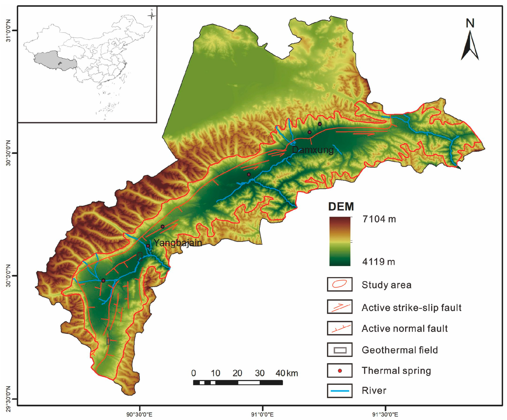
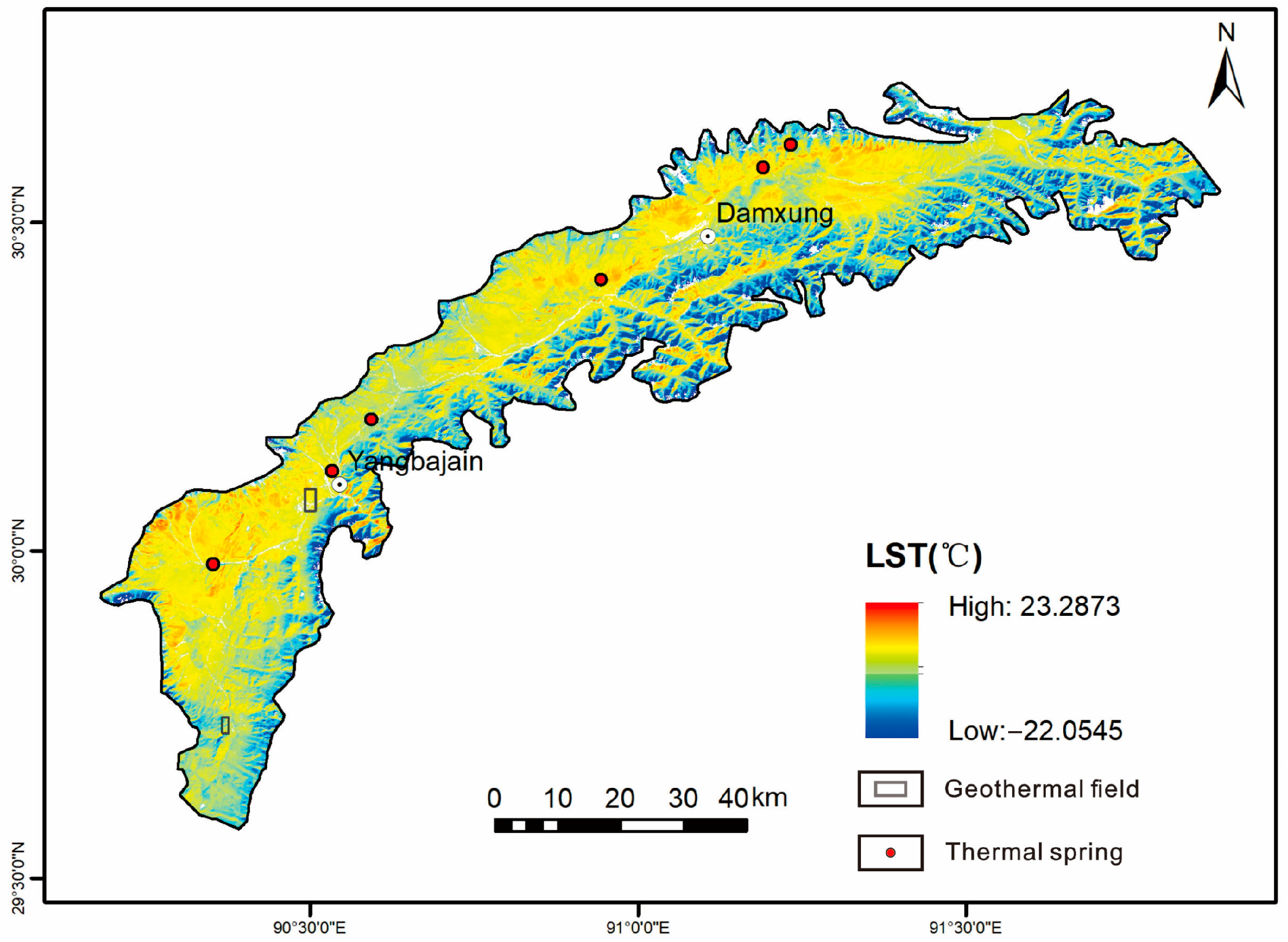
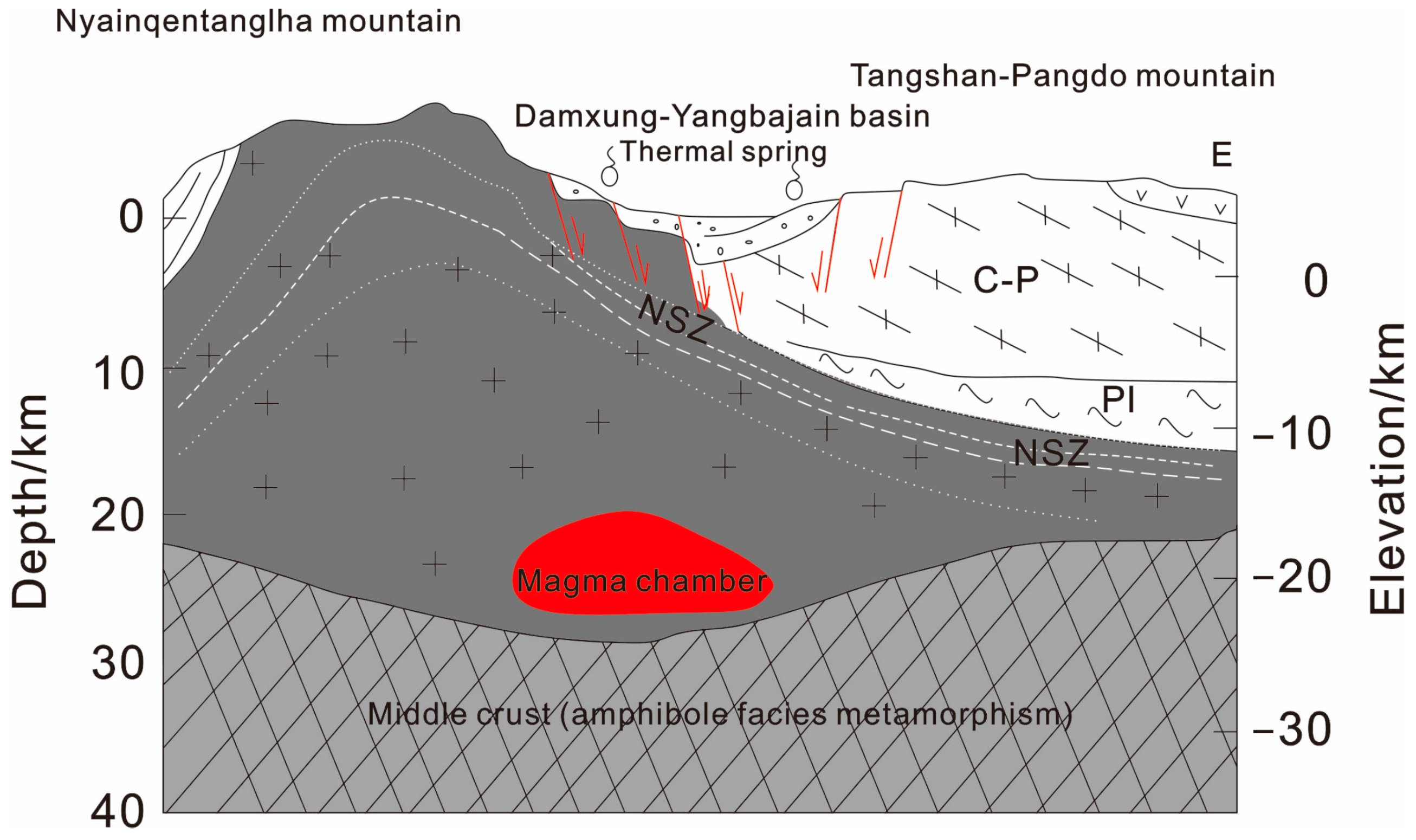
2. Geological Setting

The study area is a fault basin in the middle of the Lhasa block, located in south-central Tibet (Figure 1), stretching approximately 120 km in length and ranging from 10–15 km in width. It lies within 29~31°N and 90~92°E and demonstrates an extension in the northeastern direction [39]. The territorial terrain slopes from northwest to southeast, with an overall elevation surpassing 4100 m. The Nyainqentanglha Mountains are situated on the west side of the DYB, whereas the Tangshan–Pangdo mountains situate themselves on the southeastern side. The formation development in DYB was incomplete due to the new and Mesozoic magmatic activity, and the development of Carboniferous, Permian, Cretaceous, Tertiary rocks and Quaternary sediments [40,41]. The southeastern foot fault zone of the Nyainqentanglha Mountains, as a part of the Yadong–Gulu rift zone, runs through the entire study area. The active faults with strikes of North–East, North–South, East–West have developed well and are conducive to geothermal formation. The faults exhibited vigorous activity during the Quaternary period and is a significant seismic activity zone within the plateau, directly impacting the geothermal and magma activity in the basin [39,41,42,43,44].
There are many geothermal manifestations in the study area, including two well-known geothermal fields, namely Yangbajain geothermal field and Yangyi geothermal field. Yangbajain geothermal field has three geothermal reservoirs. The origin of the primary geothermal fluid was the third reservoir, characterized by temperatures around 320 °C and located at a depth of approximately 8 km. In the second reservoir, temperatures hovered at approximately 250 ± 10 °C, while the first reservoir maintained temperatures of 150 ± 15 °C [45]. The Yangbajain power station established in 1977 is the most famous geothermal power plant in China, boasting an impressive total installed capacity of 25.15 MW. The Yangbajain plant is situated within the central-northern region of the Yadong-Gulu rift zone, distributed in a north-south direction [41]. Drilling outcomes within the Yangyi geothermal field unveil remarkable water temperatures reaching up to 100 °C [46]. The Yangyi power station, constructed in 2018, stands as China’s tallest geothermal power plant and is situated in the southern part of the Damxung–Yangbajain–Duoqingco Active Fault Zone in central Tibet. With an accumulated power generation surpassing 500 million kWh, Yangyi plant holds the distinction of being China’s sole commercially operational geothermal power station. The rivers in the study area mainly include Sangqu, Buqu, Dangqu, Laqu and Nimu Maqu, which serve as the primary sources of abundant groundwater resources. These rivers rely mainly on rainfall while also being supplemented by melting snow and groundwater.
Figure 1. Geographic location and tectonic map of the study area (fault data vectorization from the literature [47]).
Remotesensing 15 04473 g001

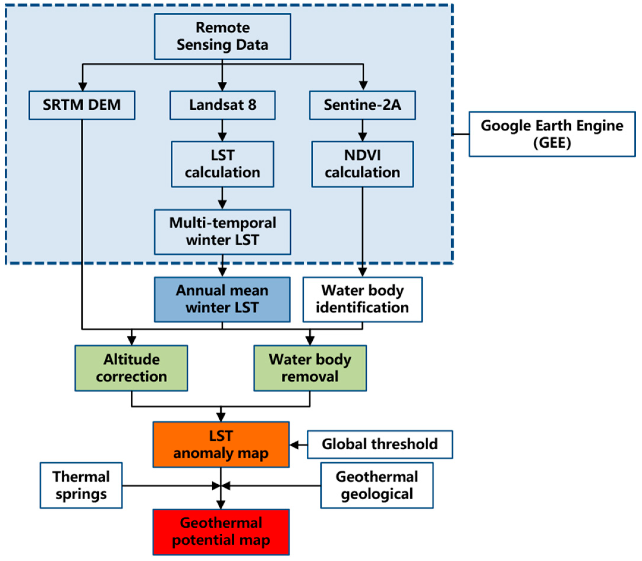
3. Materials and Methods

3.1. Materials

3.1.1. Landsat 8 Data

Landsat 8 TIR data is chosen for its superior spatial resolution, which facilitates precise identification and localization of thermal anomaly areas [11]. In recent years, research and application of each band of the Landsat 8 satellite have advanced significantly, and the utilization of its TIR remote sensing data for detecting geothermal resources and high-temperature anomalies has garnered significant attention from scholars worldwide. Landsat 8 carries two sensors, namely the Thermal Infrared Sensor (TIRS) and the Operational Land Imager (OLI). This paper chooses remote sensing data acquired by the TIRS installed on Landsat 8, which was launched on 11 February 2013. The OLI collects images using nine spectral bands in various wavelengths of visible, near-infrared, and shortwave light, enabling it to observe a swath of the Earth 185 km (115 miles) wide with a resolution of 15–30 m. The TIRS bands 10–11 are originally captured at a resolution of 100 m, but they are resampled to 30 m to align with the resolution of OLI multispectral bands. The thermal infrared band offers a resolution of 100 m, revisiting every 16 days, and has the ability to detect temperature variations within the range of 0.2–0.5 °C [48,49].
To account for the significant radiation calibration deviations in the Landsat 8 TIRS Band 11, as documented in several studies [18,50,51], we calculated the LST using the Landsat 8 thermal band (Band 10) in conjunction with the mono-window algorithm (MW) within GEE. The wavelength range of Band 10 is 10.6~11.2 μm. In this paper, the mean winter LST obtained from the inversion of Landsat 8 remote sensing data is used. Winter acquisitions (December to February) are effective in mitigating the LST anomaly induced by solar radiation. The use of a long-time series of mean LST data can effectively eliminate system errors and reduce the impact of LST anomalies caused by random and accidental events. Finally, we obtain the mean winter LST for 6 years.

3.1.2. Google Earth Engine

Google Earth Engine (GEE) is a geospatial cloud computing platform that was developed jointly by Google, Carnegie Mellon University, and the US Geological Survey. GEE grants effortless access to powerful computing resources, facilitating online analysis and visualization of massive geospatial datasets. It is perfect for handling petabyte-level geographic information big data [52]. GEE includes API interfaces, analysis algorithms, and tools based on JavaScript and Python languages, which are convenient for users to perform large-scale data processing, analysis, and information mining [53].
The GEE data catalog not only provides users with more than 40 years of Landsat series satellite imagery and other image data sets of different resolutions, but also provides elevation data, meteorological data, and demographic data, etc. These datasets have been preprocessed into an easy-to-use format that preserves the information content and allows for efficient access. The utilization of this platform greatly reduces the barriers associated with data management and enables more efficient and effective data analysis [52]. Compared to paid remote sensing image processing tools such as ENVI, GEE offers several advantages, including free and extensive data selection, batch processing, and visual computing. With its vast collection of data sets and powerful background computing capabilities, GEE can meet the various data processing and analysis needs of users [54]. Using GEE, we can efficiently obtain the desired results quickly by pre-writing the necessary code. Furthermore, these results can be easily used for further analysis. This approach streamlines the research process, enhancing efficiency and productivity.
To achieve our research goals, we utilized the GEE to derive Landsat-derived LST products. To enhance the accuracy of the results, we also employed GEE to compute the Normalized Difference Vegetation Index (NDVI) for water body identification and obtain DEM data for altitude correction.

3.2. Methods

3.2.1. LST Computation

There are various algorithms for LST inversion, including the radiative transfer equation (RTE) algorithm (also known as atmospheric correction), the mono-window algorithm (MW) algorithm, and the split-window (SW) algorithm [55,56,57]. However, the RTE algorithm requires real-time atmospheric profile parameters, which is not suitable for batch inversion of LST. The SW algorithm, which requires data from two thermal infrared channels of Landsat 8, is also not recommended due to the incomplete calibration parameters of band 11 [49]. Therefore, in this study, we use the MW algorithm for LST batch inversion, employing multi-temporal Landsat series image data in GEE. The MW algorithm is widely recognized for its simplicity, high efficiency, and lack of requirement for atmospheric profiles. Its advantage lies in the fact that it only requires three basic parameters: surface emissivity, atmospheric transmittance, and average atmospheric temperature [58,59]. In general, the MW algorithm exhibits a mean error below 1.5 K [50].
Before inverting the LST, preprocessing of the data is necessary, including atmospheric correction, geometric correction, and radiometric calibration. Eventually, the LST is derived by applying the MW algorithm, for which the calculation formula is used. The calculation formula is:
Ts = {a (1 − C − D) + [b (1 − C − D) + C + D]Tb − DTa}/C,
C = τ ε,
D = (1 − τ)[1 + τ (1 − ε)],
where Ts is the LST (K); ε is the surface emissivity; τ is the atmospheric transmittance; Tb is the pixel brightness temperature of the thermal infrared band (K); and Ta is the average atmospheric temperature (K). C and D are the intermediate variables; a and b are the linear regression coefficient.
Landsat LST is not readily available as a pre-processed product, and it can be computed based on data from the TIR bands at a spatial resolution of 30 m [60,61]. GEE offers Landsat images that have undergone atmospheric correction, geometric correction, and radiometric calibration. In this study, we computed the LST from the Landsat 8 thermal band (Band 10) on GEE in a fast and efficient manner.

3.2.2. Geothermal Anomalies Extraction from LST

TIR remote sensing technology provides accurate, intuitive, and fast detection of LST anomalies at different times and large spatial scales. However, various factors such as solar radiation, altitude, and meteorological conditions can influence remotely sensed LST and restrict its use. To overcome these limitations, recent literature reports several techniques, including altitude correction techniques [62], the utilization of multi-source data sets [35], and analysis of multi-temporal images to account for different meteorological conditions [1]. In this paper, we applied the altitude correction techniques and water body removal to enhance the precision of the multi-temporal derived LST.
The reliability of results derived from multi-temporal TIR remote sensing images surpasses that of results obtained from single-temporal TIR remote sensing images. The long-term series of mean LST data used in this study can minimize systematic errors and reduce the impact of geothermal anomalies caused by random or accidental events. To minimize interference, geothermal anomaly mapping primarily relies on winter acquisitions (December to February) to isolate the geothermal signal [35,63]. The global threshold method was employed to extract LST anomaly zones. The proposal suggests using 1.5, 2.0, and 2.5 times the standard deviation added to the mean value as thresholds to extract the weak, medium, and strong LST anomaly areas, respectively. We preliminarily identify the geothermal potential zones, where the annual mean winter LST exceeds the sum of its average value plus one standard deviation. Afterwards, the geothermal potential areas are further delineated based on the characteristics of the geological structure. Furthermore, the thermal springs and geothermal fields are applied to validate the accuracy of the delineation results. The specific implementation process is shown in Figure 2.

4. Results

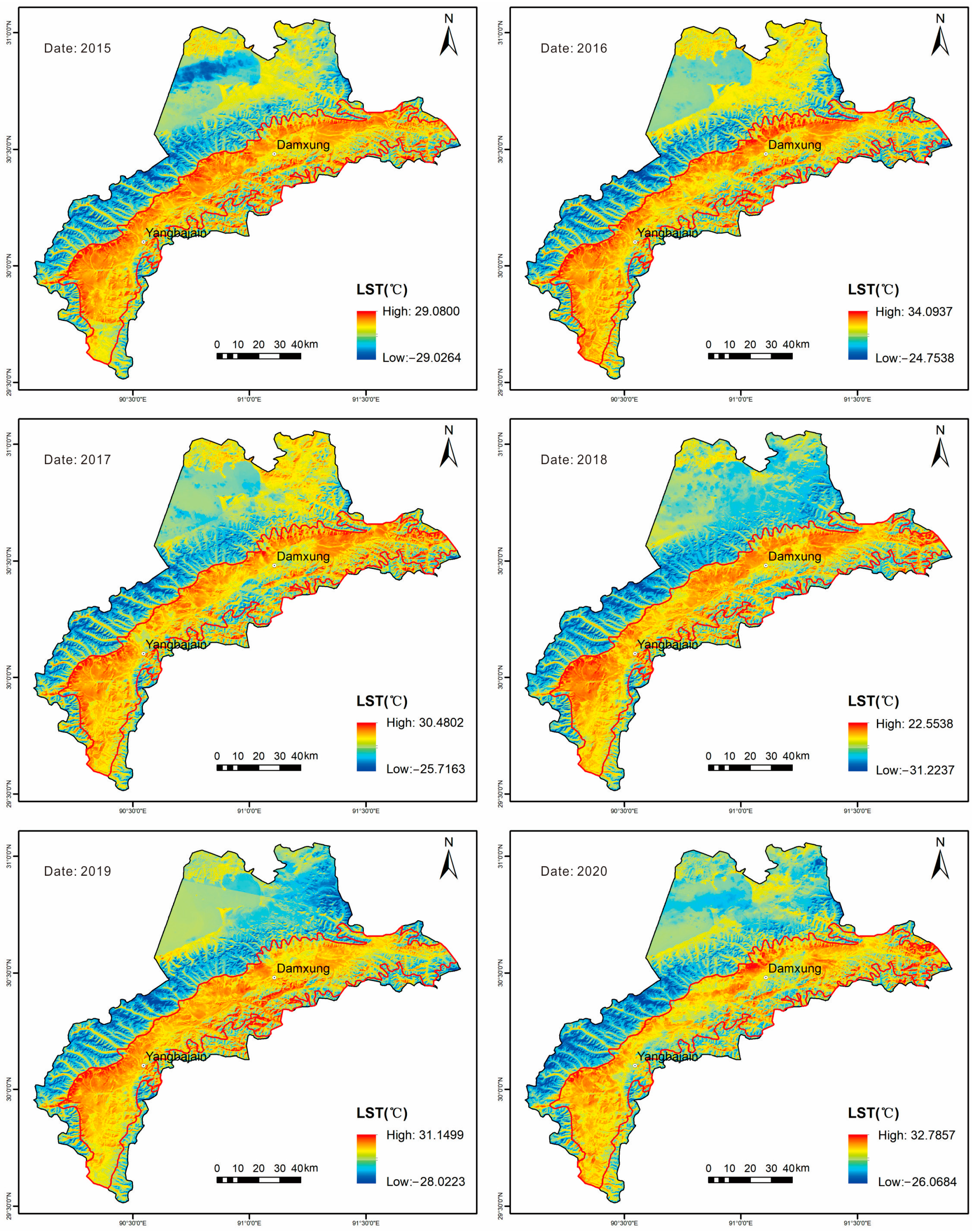
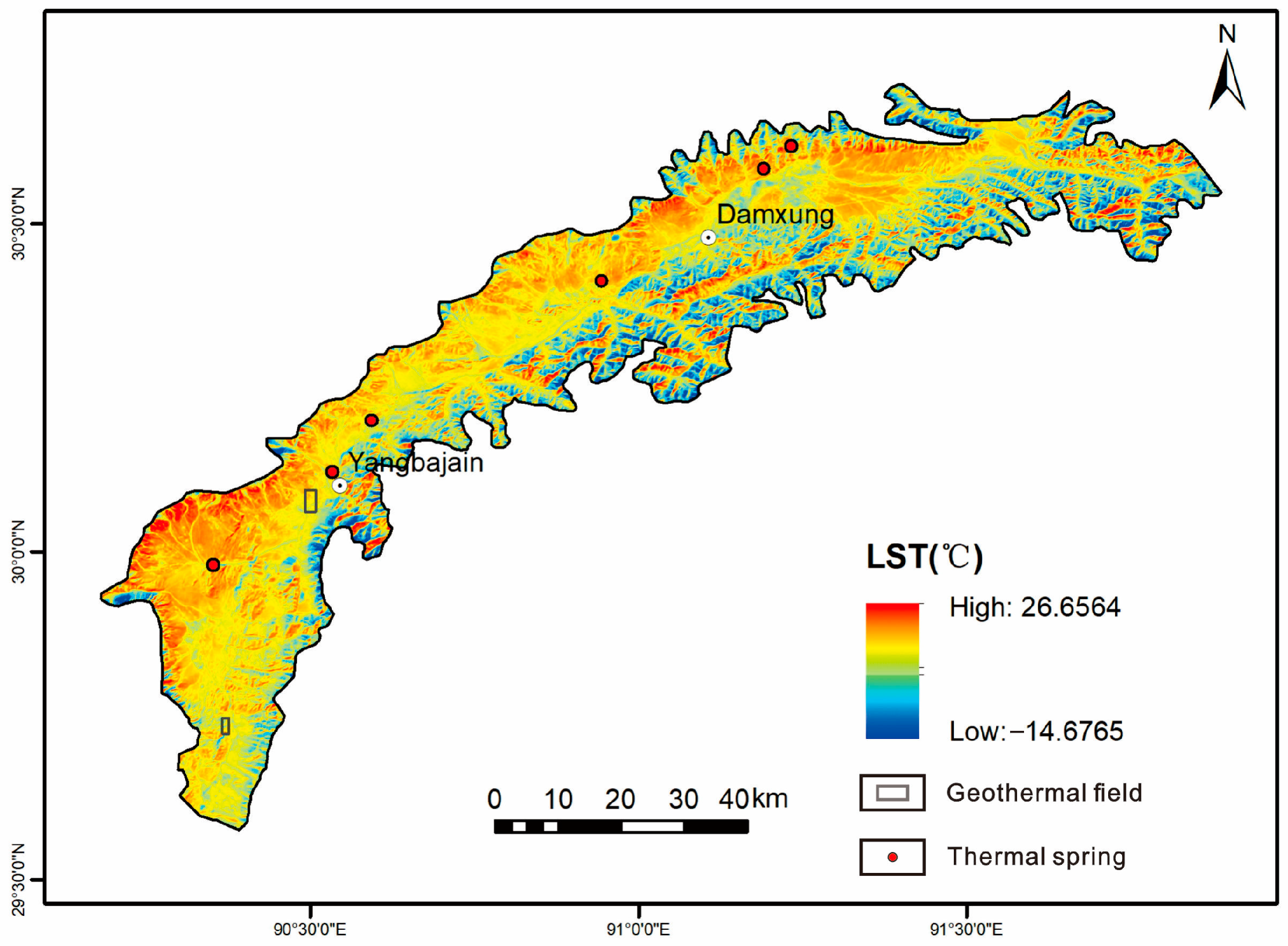
4.1. Land Surface Temperature (LST) Results

4.1.1. Land Surface Temperature

The sporadic identification of LST anomalies, based on a single image, may not provide conclusive evidence of geothermal anomalies. Therefore, we established a long time series of LST. To better isolate the geothermal signals, geothermal anomalies are typically identified using multi-temporal LST from winter acquisitions [35,63]. As shown in Figure 3, the higher LST regions were concentrated in similar regions over the past six years, which indicates that the distribution of high LST anomaly regions has a considerable stability and the derived LST results are reliable.
The mean winter LST distribution map of Damxung from 2015 to 2020 is shown in Figure 3. The mean winter LST ranges from −31.2 °C to 34.1 °C, with an average of −3.5 °C to 6.9 °C and a standard deviation of 8.2 °C to 8.9 °C. The mean winter LST in Damxung County reaches its minimum at approximately −30 °C, with the lowest recorded temperature being −31.2 °C in 2018. On the other hand, the highest mean winter LST was recorded around 30 °C, with the maximum reaching 34.1 °C in 2017. These figures illustrate a general pattern of lower LST in the western region of the Nyainqentanglha Mountains, while higher LST are observed in the eastern region.
Figure 4 presents the statistical results of the LST in Damxung County. Notably, in 2016, the average of the mean winter LST was the highest at 6.9 °C, while it reached its lowest point at −3.5 °C in 2018.

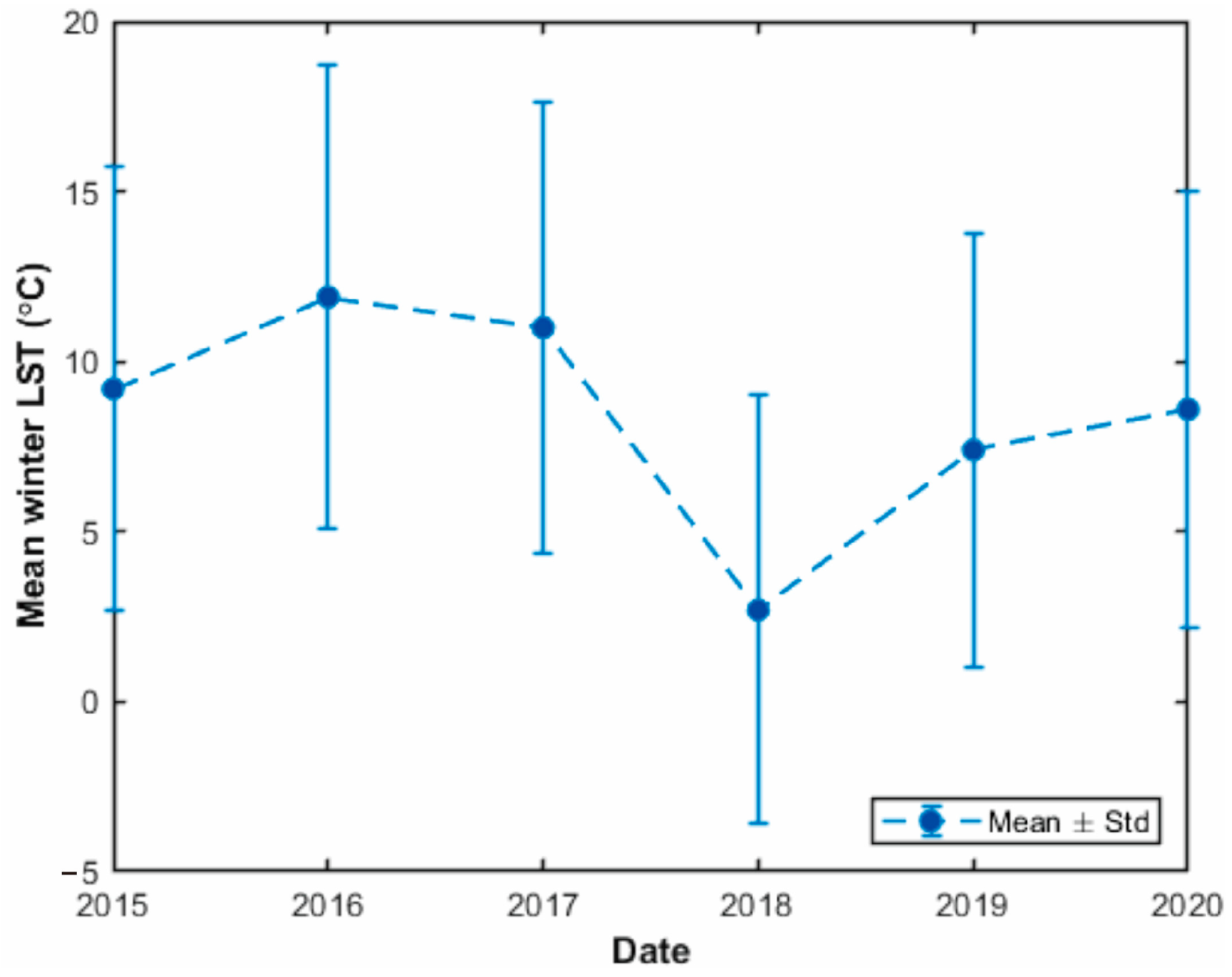
4.1.2. Annual Mean Winter LST

It (Figure 3) can be observed that the LST anomalies are primarily concentrated in DYB, rather than the Nyainqentanglha and Tangshan–Pangdo mountains. To minimize the impact of various factors such as vegetation, terrain, and human activities on the LST anomalies, we only discuss the characteristics of the LST within DYB. The results of a 6-year time series of mean winter LST from 2015 to 2020 are shown in Figure 5. These LST maps show similar spatial distribution characteristics. The LST anomaly area is mainly distributed in the basin or in some piedmont areas. Over the six years, the mean winter LST ranged from −21.2 °C to 34.1 °C, with an average of 2.7 °C to 11.9 °C and a standard deviation of 6.3 °C to 6.8 °C.
Figure 6 presents the statistical results of the LST in DYB. The average of the mean winter LST was the highest at 11.9 °C in 2016, while it reached its lowest point at 2.7 °C in 2018.
To eliminate errors caused by occasional surface temperature changes and to distinguishing the geothermal signal from alternative sources of LST anomalies, we used a long-term series of mean LST data spanning the winter periods from 2015 to 2020. We argued that the use of a 6-year time series of LST is long enough to distinguish the geothermal sign from alternative sources of LST anomalies, as suggested by recent research [37]. We calculated the annual mean winter LST (Figure 7) to produce an LST anomaly map. The annual mean winter LST of the study area varied from −14.7 °C to 26.7 °C, with an average of 8.6 °C.

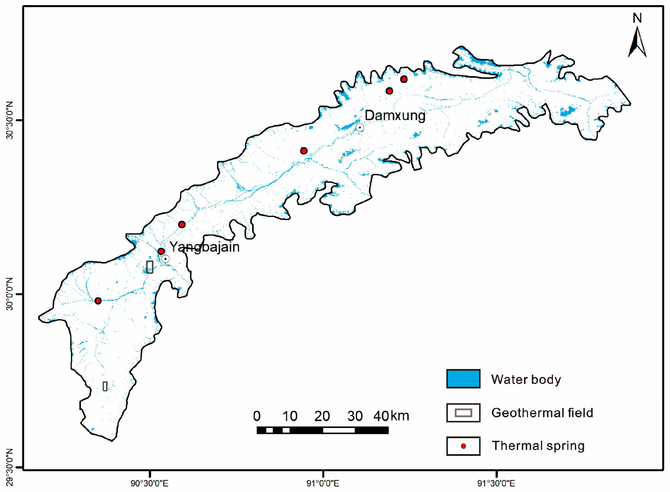
4.1.3. Water Body Removal

The water body, such as lakes or rivers, has different thermal properties compared to the surrounding land. When their temperatures are lower than the bare land temperature, they can create a false impression of temperature anomalies in the surrounding areas. We found a daytime cold anomaly and a contrasting higher thermal anomaly during nighttime for the water body. By excluding the water body from the LST map, it allows us to focus specifically on the thermal characteristics of the land surface, improving the accuracy of geothermal anomaly detection, and reducing the chances of misinterpretation caused by the presence of the water body.
(1)
Water body extraction
When NDVI falls below 0, it signifies a predominant coverage of water bodies such as clouds, water, and snow within the pixel. This paper calculates the NDVI through the GEE. As illustrated in Figure 8, the NDVI values fall within the range of −0.4 to 0.5, averaging at 0.1. The spatial distribution of vegetation shows a clear north to south gradient, with higher vegetation coverage observed in the northern region compared to the southern region. The distribution map of the water body is displayed in Figure 9. The water body identified at the study area’s periphery is potentially snow-covered mountains, whereas the linearly distributed water body observed within the study area is likely comprised of rivers, in alignment with the known distribution of the regional river system.
(2)
Water body removal
We used the GIS for water body removal. The distribution of LST after excluding the water body area is illustrated in Figure 10. The blank area represents the identified location of the water body.

4.1.4. Altitude Correction

Altitude has an impact on temperature, as higher elevations typically have lower temperatures due to the lapse rate of the atmosphere. By standardizing the LST data to a uniform elevation, we eliminate the confounding influence of altitude on temperature readings. In summary, altitude correction allows us to better capture temperature anomaly signals caused by subsurface heat sources.
To account for altitude effects, the derived LST data was adjusted using the Altitude-LST least squares regression equation, as outlined below:
LandsatLST = 42.35 − 0.007 × Altitude,
where the Landsat LST represents Landsat 8-derived LST in °C, while the altitude is determined from the SRTM DEM in meters. The regression equation yields an R2 of 0.82.
The relationship between elevation and LST is employed to adjust the LST to a reference elevation, thereby enabling the identification of LST anomalies and mitigating the negative impact of topographic relief on LST anomaly detection [15]. In this study, we transformed the LST into its equivalent value at 4300 m above sea level. Thus, the LST after altitude correction was computed using the following formula:
LandsatLSTcorrected = LandsatLST + 0.007 × (4300 − Altitude),
Figure 11 illustrates the spatial distribution of the annual mean winter LST after correcting for altitude and excluding the water body. The annual mean winter LST was distributed between −22.1 °C and 23.3 °C, with an average of 6.2 °C and a standard deviation of 6.6 °C. After altitude correction and water body removal, it allows us to focus specifically on thermal variations related to geothermal activity, enabling more accurate identification and analysis of geothermal anomalies. All subsequent analysis are conducted based on the corrected annual mean winter LST.

4.2. Geothermal Anomalies Extraction

4.2.1. Extraction of LST Anomaly Areas

We obtained the annual mean winter LST to generate the LST anomaly map (Figure 12). The map indicates areas with weak LST anomalies in orange, moderate anomalies in purple, and strong anomalies in red. The majority of the LST anomaly areas are the weak LST anomaly areas. The LST anomaly areas can be categorized into two types. The first type consists of dispersed LST anomaly areas located away from the fault zone, likely attributable to urban areas and roads. The second type primarily encompasses LST anomaly areas concentrated near the fault zone, suggesting a higher likelihood of developing geothermal resources.
Table 1 shows the relevant results of different LST anomaly areas.

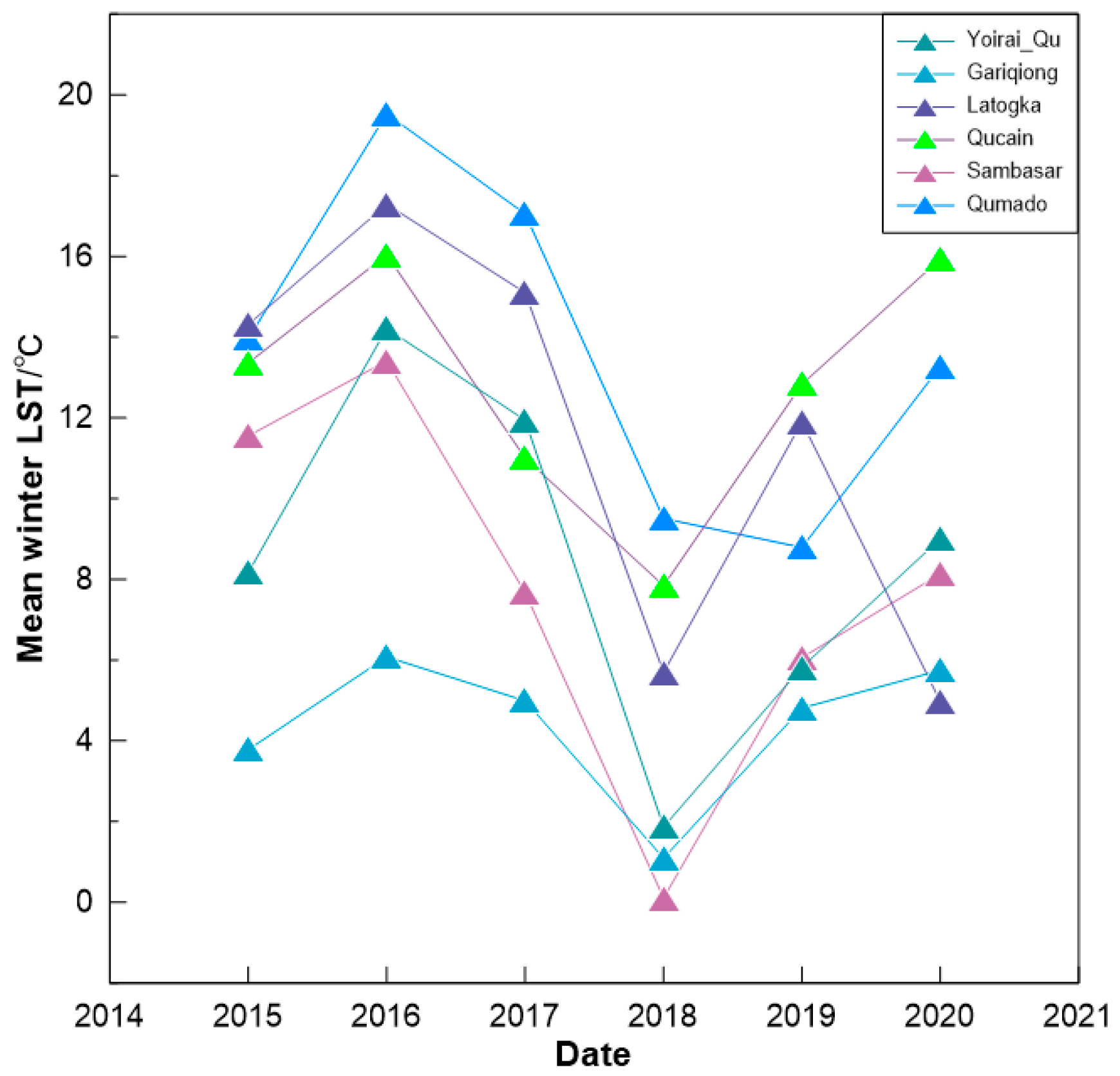
4.2.2. LST Changes of Thermal Springs

Natural thermal springs are formed through the movement of hot water from the deep earth’s crust along active faults, leading to enrichment and upflow to the surface. These thermal springs are a significant indicator of thermal manifestations and play a vital role in geothermal release. Therefore, the location of natural thermal springs is likely to correspond to areas with relatively developed geothermal reservoirs. As a result, the study of spatio-temporal variation in the LST at thermal springs has a crucial guiding role in identifying potential areas for geothermal resource exploration.
Figure 7 shows that the thermal springs are consistently located in regions with high LST values. As shown in Figure 12, it appears that the six known thermal springs are distributed in the LST anomaly area along the NE-trending faults. Table 2 provides details about the six thermal springs within the study area.
In Figure 13, it is evident that over the course of six years, the annual mean winter LST of the six thermal springs exhibits a similar pattern of change. Additionally, it can be observed that the annual mean winter LST of most thermal springs surpasses their respective average values.

4.2.3. Geothermal Potential Mapping

The annual winter mean LST results were utilized to create and examine the geothermal potential map. The threshold for geothermal anomaly zones was defined using the annual mean winter LST. The threshold is set as the mean temperature plus one standard deviation (σ) using LST data from all winter acquisitions (December to February) [64]. This approach relies on the complete Landsat winter time series, capturing comprehensive data on land surface thermal properties as opposed to a single image. As a result, the findings are considerably more dependable and accurate.
Geothermal energy is transmitted to the ground through active faults, making the distribution of faults in a region a crucial factor in studying the geothermal distribution and identifying genuine geothermal anomalies [65]. Previous research has demonstrated that the intersection of faults and thermal anomalies, as well as their proximity, are ideal locations for geothermal exploration. The distribution of geothermal anomalies and faults is strongly correlated and can serve as a basis for geothermal detection [66,67]. Therefore, this paper suggests that LST anomalies occurring along faults are more likely to indicate areas of geothermal resources development. Taking into account the unique features of the regional geological structure, we mapped out potential geothermal areas alongside the NE-trending fault area at the southeastern foot fault zone of the Nyainqentanglha Mountains.
The study findings reveal that geothermal anomalies consistently exhibit higher average winter LST with reduced variability, contrasting with non-geothermal regions. In our study area, we have identified remarkable geothermal anomalies with a magnitude of the thermal anomaly as high as 19.6%. Figure 14 demonstrates that the geothermal anomaly zones cover approximately 418.7 km2, making up 8.2% of the entire study area. Geothermal anomaly areas exhibited a higher LST ranging from 12.6 °C to 23.3 °C. Meanwhile, within the identified geothermal potential areas there are known thermal springs. Geothermal potential zones have been identified in both geothermal fields, namely the Yangbajain geothermal field and the Yangyi geothermal field. Figure 14 illustrates the distribution of the geothermal potential zone, which aligns with that of the higher LST and corresponds to well-known geothermal manifestations. This alignment exhibits a NE–SW trend that closely follows the fault direction. These findings indicate the reliability of the identified geothermal potential areas.

5. Discussion

5.1. Uncertainties of the Proposed Method

During the geothermal detection process, in applying TIR remote sensing technology the benefits of this method can be fully utilized, leading to a high degree of accuracy in LST anomaly detection. However, the study also has its limitations and challenges, indicating that further research in related fields is necessary:
(1)
The method has a limitation due to the partial availability of winter time series data, resulting in the estimation of different locations with varying time series structures. For instance, certain pixels may possess comprehensive time series, while others rely on only a limited number of observations over the study period. However, the utilization of sufficiently long time series, as demonstrated in this study, significantly reduces the likelihood of pixels containing insufficient LST data.
(2)
While TIR remote sensing technology is a useful method for identifying large-scale geothermal anomalies, it has limitations in accurately determining the location of geothermal resources. As a result, it can provide a general understanding of the current state and dynamic changes of geothermal activity in the region, but it cannot provide precise information on the location of geothermal resources.
Surface thermal anomalies caused by the earth’s internal heat source primarily result from the heat conduction of rocks and the thermal convection of groundwater to the shallow surface. However, the emergence of these anomalies is limited due to the very low thermal conductivity of the rocks and underdeveloped structures. Consequently, TIR remote sensing technology can only be utilized as a supplementary geothermal investigation method, with traditional geophysics remaining the primary means of exploration. To achieve the most optimal results and ensure mutual corroboration, TIR remote sensing must be combined with other tectonic analysis.

5.2. Mechanism of Geothermal Anomalies

The Quaternary tectonic activity in the study area is strong with abundant fault structures, and is famous for its remarkable geothermal and magmatic activities [44]. The basin contains a substantial amount of bedrock fissure water, with particularly rich water reserves in the deep system [42]. Additionally, there is a vast melted magma chamber (10–15 km) located deep beneath the DYB (Figure 15) that can serve as an excellent heat source [68]. The DYB is characterized with a crustal heat resource, including high radiogenic heat production and melt magmas, which is significantly distinguished from the eastern part of China [69,70,71]. As the focus of attention in the study area, the genetic mechanism of Yangbajain geothermal field is described. The Yangbajain geothermal field has three geothermal reservoirs. The deeper reservoir encompasses fissure granitic mylonite, biotite granite, and fissure granites that are overlain by intensely weathered granites. These weathered granites exhibit low permeability due to the alteration of initial feldspar into kaolinite. The shallow geothermal reservoir is mainly weathered granite and Quaternary sandstone in the northwest and Himalayan granite in the southeast, and consists of loose sand scintillates of the Quaternary system, with a muddy layer or a hydrothermal cement layer as a cover layer on the upper part. The underground hot water is heated by a magma chamber, and surges upward along the bedrock fracture or the basin boundary fracture. It then enters into the quaternary voids with good permeability to form the geothermal reservoir layer when it is close to the ground surface [45,46].
The identified geothermal potential areas are situated near the fault zone, where fractures intersect the surface and create a structural fissure that allows hot water to seep through the fracture structure and magma. With rising temperatures, structural fissure water undergoes expansion, prompting convection driven by deep thermal and surrounding rock pressure. Subsequently, heated water moves upward through thermal conductive structures or fissures towards thermal storage formations. In some cases it reaches the surface, giving rise to thermal springs and causing anomalies in the LST [20,50]. The study area possesses favorable conditions for the development and preservation of geothermal resources. As a result, the identified results are supported by geological information.

6. Conclusions

This study introduces a new methodology to detect geothermal resources through the utilization of multi-temporal TIR remote sensing data during the winter season. The Landsat series is used within GEE in plateau environments, using the DYB as a case study. Differing from previous research, this methodology does not rely on a single remote sensing image; instead, it exploits the complete Landsat time series in winter to extract surface thermal properties, eliminating any spurious geothermal anomalies. The results also highlight the significance and efficacy of using multi-temporal TIR remote sensing data for identifying geothermal anomalies, presenting a fresh perspective for intelligently delineating such areas.
The annual mean winter LST in DYB ranges from −14.7 °C to 26.7 °C, with an average of 8.6 °C. After altitude correction and water body removal, the annual mean winter LST is −22.1 °C to 23.3 °C, with an average of 6.2 °C. Geothermal anomalies exhibited higher LST varying from 12.6 °C to 23.3 °C. The results indicate a strong correlation between the distribution of geothermal potential zones and regions with a higher LST, aligning closely with the NE-trending fault structure. The magnitude of geothermal anomaly reaches as high as 19.6%, indicating the presence of pronounced geothermal anomalies. The geothermal potential zone is approximately 418.7 km2, making up 8.2% of the entire study area. The presence of known thermal springs and geothermal fields indirectly validates the reliability of the identification results. Geothermal anomalies are strongly associated with NE-trending fault structures. Faults serve as conduits for heat transfer and reservoirs for geothermal activity, aiding in the identification of local LST anomalies. This correlation could be a direction for future geothermal research.
However, TIR remote sensing technology can only provide an approximate range of geothermal resources, and cannot accurately pinpoint the location of geothermal anomalies. With complementary geological information, the accuracy of geothermal detection based on multi-temporal TIR remote sensing technology may be significantly improved. Additionally, researchers must interpret research findings with caution due to the inherent uncertainties in satellite-derived LST products.

Author Contributions

Conceptualization, X.T.; Methodology, X.L. and G.J.; Formal analysis, X.L.; Data curation, X.L.; Writing—original draft, X.L.; Writing—review & editing, G.J., X.T., Y.Z., S.H., C.Z., Y.W. (Yaqi Wang), Y.W. (Yibo Wang) and L.Z.; Supervision, G.J. All authors have read and agreed to the published version of the manuscript.

Funding

This research was funded by Natural Science Foundation of China (No.: 42130809, 42004076, 41888101, 42074096, 41922912). The APC was funded by [42130809].

Data Availability Statement

The data underlying this article are available in the paper and published on Mendeley (https://data.mendeley.com/datasets/tdp2krwtsf/1 (accessed on 11 May 2023)). The code is available from the GEE (https://code.earthengine.google.com/e4c4eb880a532a1e35a53d52d7902695 (accessed on 1 August 2023)).

Acknowledgments

We are grateful to the editors and all the reviewers for their effort reviewing our paper.

Conflicts of Interest

The authors declare no conflict of interest.

References

  1. Chan, H.; Chang, C.; Dao, P.D. Geothermal Anomaly Mapping Using Landsat ETM+ Data in Ilan Plain, Northeastern Taiwan. Pure Appl. Geophys. 2018, 175, 303–323. [Google Scholar] [CrossRef]
  2. Hou, J.; Cao, M.; Liu, P. Development and utilization of geothermal energy in China: Current practices and future strategies. Renew. Energy 2018, 125, 401–412. [Google Scholar] [CrossRef]
  3. Li, D.; Wang, Y. Major Issues of Research and Development of Hot Dry Rock Geothermal Energy. Earth Sci. J. China Univ. Geosci. 2015, 40, 1858–1869. [Google Scholar]
  4. Li, K.; Bian, H.; Liu, C.; Zhang, D.; Yang, Y. Comparison of geothermal with solar and wind power generation systems. Renew. Sustain. Energy Rev. 2015, 42, 1464–1474. [Google Scholar] [CrossRef]
  5. Guan, X. The situation, measures & suggestions on the exploration and utilization of geothermal resources. China Min. Mag. 2010, 19, 7–9. [Google Scholar]
  6. Zhang, C.; Jiang, G.; Jia, X.; Li, S.; Zhang, S.; Hu, D.; Hu, S.; Wang, Y. Parametric study of the production performance of an enhanced geothermal system: A case study at the Qiabuqia geothermal area, northeast Tibetan plateau. Renew. Energy 2019, 132, 959–978. [Google Scholar] [CrossRef]
  7. Zhang, C.; Wang, X.; Jiang, C.; Zhang, H. Numerical simulation of geothermal energy production from hot dry rocks under the interplay between the heterogeneous fracture and stimulated reservoir volume. J. Clean. Prod. 2023, 414, 137724. [Google Scholar] [CrossRef]
  8. Zhang, L.X.; Pang, M.Y.; Han, J.; Li, Y.Y.; Wang, C.B. Geothermal power in China: Development and performance evaluation. Renew. Sustain. Energy Rev. 2019, 116, 109431. [Google Scholar] [CrossRef]
  9. Wang, S.; Lu, C.; Nan, D.; Hu, X.; Shao, J. Geothermal resources in Tibet of China: Current status and prospective development. Environ. Earth Sci. 2017, 76, 239. [Google Scholar] [CrossRef]
  10. Abubakar, A.J.A.; Hashim, M.; Pour, A.B. Remote sensing satellite imagery for prospecting geothermal systems in an aseismic geologic setting: Yankari Park, Nigeria. Int. J. Appl. Earth Obs. Geoinf. 2019, 80, 157–172. [Google Scholar] [CrossRef]
  11. Chao, J.; Zhao, Z.; Lai, Z.; Xu, S.; Liu, J.; Li, Z.; Zhang, X.; Chen, Q.; Yang, H.; Zhao, X. Detecting geothermal anomalies using Landsat 8 thermal infrared remote sensing data in the Ruili Basin, Southwest China. Environ. Sci. Pollut. Res. 2022, 30, 32065–32082. [Google Scholar] [CrossRef] [PubMed]
  12. Bezerra, F.G.S.; Aguiar, A.P.D.; Alvalá, R.C.S.; Giarolla, A.; Bezerra, K.R.A.; Lima, P.V.P.S.; Do Nascimento, F.R.; Arai, E. Analysis of areas undergoing desertification, using EVI2 multi-temporal data based on MODIS imagery as indicator. Ecol. Indic. 2020, 117, 106579. [Google Scholar] [CrossRef]
  13. Wu, Z.; Lei, S.; Bian, Z.; Huang, J.; Zhang, Y. Study of the desertification index based on the albedo-MSAVI feature space for semi-arid steppe region. Environ. Earth Sci. 2019, 78, 232. [Google Scholar] [CrossRef]
  14. Wang, Y.; Pang, Z. Heat flux in volcanic and geothermal areas: Methods, principles, applications and future directions. Gondwana Res. 2022; in press. [Google Scholar] [CrossRef]
  15. Xiong, Y.; Chen, F.; Huang, S. Application of remote sensing technique to the identification of geothermal anomaly in Tengchong area, southwest China. J. Chengdu Univ. Technol. (Sci. Technol. Ed.) 2016, 43, 109–118. [Google Scholar]
  16. Liu, S.; Ye, C.; Sun, Q.; Xu, M.; Duan, Z.; Sheng, H.; Wan, J. Detection of Geothermal Anomaly Areas with Spatio-Temporal Analysis Using Multitemporal Remote Sensing Data. IEEE J. Sel. Top. Appl. Earth Obs. Remote Sens. 2021, 14, 4866–4878. [Google Scholar] [CrossRef]
  17. Weldeyohannes, T.T.; Hailu, B.T.; Muluneh, A.A.; Kidane, T. Detection of geothermal anomalies in the Northern Lake Abaya geothermal field, Main Ethiopian Rift. J. Volcanol. Geotherm. Res. 2022, 430, 107638. [Google Scholar] [CrossRef]
  18. Zhang, A.; Zhang, X. Land surface temperature retrieved from Landsat-8 and comparison with MODIS temperature product. J. Beijing For. Univ. 2019, 41, 1–13. [Google Scholar]
  19. Sekertekin, A.; Arslan, N. Monitoring thermal anomaly and radiative heat flux using thermal infrared satellite imagery—A case study at Tuzla geothermal region. Geothermics 2019, 78, 243–254. [Google Scholar] [CrossRef]
  20. Van der Meer, F.; Hecker, C.; van Ruitenbeek, F.; van der Werff, H.; de Wijkerslooth, C.; Wechsler, C. Geologic remote sensing for geothermal exploration: A review. Int. J. Appl. Earth Obs. Geoinf. 2014, 33, 255–269. [Google Scholar] [CrossRef]
  21. Qin, Q.; Zhang, N.; Nan, P.; Chai, L. Geothermal area detection using Landsat ETM+ thermal infrared data and its mechanistic analysis—A case study in Tengchong, China. Int. J. Appl. Earth Obs. Geoinf. 2011, 13, 552–559. [Google Scholar] [CrossRef]
  22. Westermann, S.; Langer, M.; Boike, J. Spatial and temporal variations of summer surface temperatures of high-arctic tundra on Svalbard—Implications for MODIS LST based permafrost monitoring. Remote Sens. Environ. 2011, 115, 908–922. [Google Scholar] [CrossRef]
  23. Li, H.; Peng, S.; Qiao, W.; Lin, M.; Wang, Z.; Tian, L. The distribution and activity of Cenozoic magma chamber in Tengchong volcano area deduced from the MODIS multi-temporal monthly night LST data. Acta Petrol. Sin. 2011, 27, 2873–2882. [Google Scholar]
  24. Li, Z.L.; Wu, H.; Duan, S.B.; Zhao, W.; Ren, H.; Liu, X.; Leng, P.; Tang, R.; Ye, X.; Zhu, J.; et al. Satellite Remote Sensing of Global Land Surface Temperature: Definition, Methods, Products, and Applications. Rev. Geophys. 2023, 61, e2022RG000777. [Google Scholar] [CrossRef]
  25. Heasler, H.; Jaworowski, C. Hydrothermal monitoring of Norris Geyser Basin, Yellowstone National Park, USA, using airborne thermal infrared imagery. Geothermics 2018, 72, 24–46. [Google Scholar] [CrossRef]
  26. Zhang, Z. Temperature Inversion of Remote Sensing Data Zone and Investigation of Geothermal Anomaly in Yangbajing Region of Tibet. Master’s Thesis, Chengdu University of Technology, Chengdu, China, 2010; 54p. [Google Scholar]
  27. Yang, J.; Wen, X.; Tan, H. Land surface temperature using remote sensing data inversion and prediction of geothermal anomaly area in Nimu, Xizang(Tibet). Geol. Rev. 2021, 67, 1770–1779. [Google Scholar]
  28. Chen, Z.; Dong, Q.; Chen, J.; Zhao, W.; Jiang, L.; Zhang, G.; Feng, T.; Wang, D.; Bi, X.; Bian, M.; et al. Research on Quantitative Prediction and Evaluation of Geothermal Anomaly Area in Qamdo-Nyingchi Section of Sichuan-Tibet Railway. Remote Sens. Technol. Appl. 2021, 36, 1368–1378. [Google Scholar]
  29. Li, J.; Zhang, Y. GIS based information model for assessment of geothermal potential: Case study of Tengchong county, southwest China. J. Eng. Geol. 2018, 26, 540–550. [Google Scholar]
  30. Yan, B.; Qiu, S.; Xiao, C.; Liang, X. Potential Geothermal Fields Remote Sensing Identification Changbai Mountain Basalt Area. J. Jilin Univ. (Earth Sci. Ed.) 2017, 47, 1819–1828. [Google Scholar]
  31. Zhang, F. Remote Prediction of Geothermal Resource Potential in the Changbai Mountain Area. Ph.D. Thesis, Jilin University, Jilin, China, 2016; 68p. [Google Scholar]
  32. Xin, L.; Liu, X.; Zhang, B. Land surface temperature retrieval and geothermal resources prediction by remote sensing image: A case study in the Shijiazhuang area, Hebei province. J. Geomech. 2021, 27, 40–51. [Google Scholar]
  33. Gao, Y. Geothermal Detection Based on Multi-Source Thermal Infrared Remote Sensing Technology. Master’s Thesis, China University of Mining and Technology, Beijing, China, 2022; 86p. [Google Scholar]
  34. Darge, Y.M.; Hailu, B.T.; Muluneh, A.A.; Kidane, T. Detection of geothermal anomalies using Landsat 8 TIRS data in Tulu Moye geothermal prospect, Main Ethiopian Rift. Int. J. Appl. Earth Obs. Geoinf. 2019, 74, 16–26. [Google Scholar] [CrossRef]
  35. Romaguera, M.; Vaughan, R.G.; Ettema, J.; Izquierdo-Verdiguier, E.; Hecker, C.A.; van der Meer, F.D. Detecting geothermal anomalies and evaluating LST geothermal component by combining thermal remote sensing time series and land surface model data. Remote Sens. Environ. 2018, 204, 534–552. [Google Scholar] [CrossRef]
  36. Hewson, R.; Mshiu, E.; Hecker, C.; van der Werff, H.; van Ruitenbeek, F.; Alkema, D.; van der Meer, F. The application of day and night time ASTER satellite imagery for geothermal and mineral mapping in East Africa. Int. J. Appl. Earth Obs. Geoinf. 2020, 85, 101991. [Google Scholar] [CrossRef]
  37. Gemitzi, A.; Dalampakis, P.; Falalakis, G. Detecting geothermal anomalies using Landsat 8 thermal infrared remotely sensed data. Int. J. Appl. Earth Obs. Geoinf. 2021, 96, 102283. [Google Scholar] [CrossRef]
  38. Lago González, D.; Rodríguez-Gonzálvez, P. Detection of Geothermal Potential Zones Using Remote Sensing Techniques. Remote Sens. 2019, 11, 2403. [Google Scholar] [CrossRef]
  39. Yang, G.; Tang, Y.; Lei, D.; Hu, Q.; Wu, J. Holocene activity and seismic hazard analysis of faults in Damxung, Tibet. Acta Geophys. 2020, 68, 597–604. [Google Scholar] [CrossRef]
  40. Zhang, Y.; Tan, H.; Cong, P.; Shi, Z.; Yang, J. Enrichment Mechanism of B, Li, Rb, and Cs in the Geothermal System of Yangbajin-Dangxiong Rift, Tibet. Acta Sedimentol. Sin. 2022, 1–18. [Google Scholar]
  41. Wu, Z.; Zhao, X.; Wu, Z.; Jiang, W.; Hu, D. Quaternary geology and faulting in the Damxung-Yangbajain basin, southern Tibet. J. Geomech. 2006, 12, 305–316. [Google Scholar]
  42. Feng, X. Basic Characteristics of the Damxung-Yangbajain Active Tectonic Zone in Tibet and Its Influence on the Safety of the Qing-Zang Railway. Acta Geosci. Sin. 2007, 173–180. [Google Scholar] [CrossRef]
  43. Wu, Z.; Hu, D.; Liu, Q.; Xia, H.; Yan, X. The Formation and Evolution of Tectonic Landform of Damxung Area in Central Tibetan Plateau. Acta Geosci. Sin. 2002, 23, 423–428. [Google Scholar]
  44. Jiao, Q. Study of the Active Faults Using Remote Sensing and Activity Analysis. Master’s Thesis, Shandong University of Science and Technology, Qingdao, China, 2011; 100p. [Google Scholar]
  45. Wang, Y.; Li, L.; Wen, H.; Hao, Y. Geochemical evidence for the nonexistence of supercritical geothermal fluids at the Yangbajing geothermal field, southern Tibet. J. Hydrol. 2022, 604, 127243. [Google Scholar] [CrossRef]
  46. Liu, Z. The Forming Mechanism of Typical High-Temperature Geothermal Systems in Nimu-Naqu Geothermal Belt, Tibet. Ph.D. Thesis, Chinese Academy of Geological Science, Beijing, China, 2014; 111p. [Google Scholar]
  47. Zuo, J.; Wu, Z.; Ha, G.; Hu, M.; Zhou, C.; Gai, H. Spatial variation of nearly NS-trending normal faulting in the southern Yadong-Gulu rift, Tibet: New constraints from the Chongba Yumtso fault, Duoqing Co graben. J. Struct. Geol. 2021, 144, 104256. [Google Scholar] [CrossRef]
  48. Sun, H. Land Surface Temperature Retrieval Based on Thermal Infrared Remote Sensing Data and Research on the Exploring Methodology of Geothermal Resources in Dandong-Liaoyang. Master’s Thesis, Jilin University, Changchun, China, 2018; 73p. [Google Scholar]
  49. Duan, S.; Ru, C.; Li, Z.; Wang, M.; Xu, H.; Li, H.; Wu, P.; Zhan, W.; Zhou, J.; Zhao, W.; et al. Reviews of methods for land surface temperature retrieval from Landsat thermal infrared data. Natl. Remote Sens. Bull. 2021, 25, 1591–1617. [Google Scholar] [CrossRef]
  50. Wang, K.; Jiang, Q.; Yu, D.; Yang, Q.; Wang, L.; Han, T.; Xu, X. Detecting daytime and nighttime land surface temperature anomalies using thermal infrared remote sensing in Dandong geothermal prospect. Int. J. Appl. Earth Obs. Geoinf. 2019, 80, 196–205. [Google Scholar] [CrossRef]
  51. Hu, D.; Qiao, K.; Wang, X.; Zhao, L.; Ji, G. Land Surface Temperature Retrieval from Landsat 8 TIRS Data Using Mono-window Algorithm. Geomat. Inf. Sci. Wuhan Univ. 2017, 42, 869–876. [Google Scholar]
  52. Gorelick, N.; Hancher, M.; Dixon, M.; Ilyushchenko, S.; Thau, D.; Moore, R. Google Earth Engine: Planetary-scale geospatial analysis for everyone. Remote Sens. Environ. 2017, 202, 18–27. [Google Scholar] [CrossRef]
  53. Xu, H.; Liu, C.; Wang, J.; Qi, S. Study on Extraction of Citrus Orchard in Gannan Region Based on Google Earth Engine Platform. J. Geo-Inf. Sci. 2018, 20, 396–404. [Google Scholar]
  54. Ye, W.; Chen, Y.; Lu, Y.; Wu, P. Spatio-temporal variation of land surface temperature and land cover responses in different seasons in Shengjin Lake wetland during 2000—2019 based on Google Earth Engine. Remote Sens. Land Resour. 2021, 33, 228–236. [Google Scholar]
  55. Song, T.; Duan, Z.; Liu, J.; Shi, J.; Yan, F.; Sheng, S.; Huang, J.; Wu, W. Comparison of four algorithms to retrieve land surface temperature using Landsat 8 satellite. J. Remote Sens. 2015, 19, 451–464. [Google Scholar]
  56. Xu, H. Retrieval of the reflectance and land surface temperature of the newly-launched Landsat 8 satellite. Chin. J. Geophys. 2015, 58, 741–747. [Google Scholar]
  57. Yang, X. Research on the Single-Channel Algorithm for Land Surface Temperature Retrieval from Landsat8 Data. Master’s Thesis, China University of Geosciences, Beijing, China, 2015; 56p. [Google Scholar]
  58. Qin, Z.; Karnieli, A.; Berliner, P. A mono-window algorithm for retrieving land surface temperature from Landsat TM data and its application to the Israel-Egypt border region. Int. J. Remote Sens. 2010, 22, 3719–3746. [Google Scholar] [CrossRef]
  59. Qin, Z.; Zhang, M.; Arnon, K.; Pedro, B. The mono-window algorithm for calculating land surface temperature using land satellite TM6 data. Acta Geogr. Sin. 2001, 456–466. [Google Scholar] [CrossRef]
  60. Avdan, U.; Jovanovska, G. Algorithm for Automated Mapping of Land Surface Temperature Using LANDSAT 8 Satellite Data. J. Sens. 2016, 2016, 1480307. [Google Scholar] [CrossRef]
  61. Parastatidis, D.; Mitraka, Z.; Chrysoulakis, N.; Abrams, M. Online Global Land Surface Temperature Estimation from Landsat. Remote Sens. 2017, 9, 1208. [Google Scholar] [CrossRef]
  62. Gutiérrez, F.J.; Lemus, M.; Parada, M.A.; Benavente, O.M.; Aguilera, F.A. Contribution of ground surface altitude difference to thermal anomaly detection using satellite images: Application to volcanic/geothermal complexes in the Andes of Central Chile. J. Volcanol. Geotherm. Res. 2012, 237–238, 69–80. [Google Scholar] [CrossRef]
  63. Vaughan, R.G.; Keszthelyi, L.P.; Lowenstern, J.B.; Jaworowski, C.; Heasler, H. Use of ASTER and MODIS thermal infrared data to quantify heat flow and hydrothermal change at Yellowstone National Park. J. Volcanol. Geotherm. Res. 2012, 233–234, 72–89. [Google Scholar] [CrossRef]
  64. Jiang, W.; Wu, J.; Gu, L.; Yang, B.; Chen, Q.; Liu, X. Research on Underground Coal Fire Monitoring Method Based on Night Thermal Infrared Spectroscopy. Spectrosc. Spectr. Anal. 2011, 31, 357–361. [Google Scholar]
  65. Xu, Z.; Xu, S.; Zhang, S. Hydro-Geochemistry of Anning Geothermal Field and Flow Channels Inferring of Upper Geothermal Reservoir. Earth Sci. 2021, 46, 4175–4187. [Google Scholar]
  66. Ren, Z.; Liu, R.; Ren, W.; Qi, K.; Yang, G.; Cui, J.; Yang, P.; Zhang, Y. Distribution of geothermal field and its controlling factors in the Weihe basin. Acta Geol. Sin. 2020, 94, 1938–1949. [Google Scholar]
  67. Zhou, T.; Wang, Z.; Qin, H.; Zeng, Y. Remote sensing extraction of geothermal anomaly based on terrain effect correction. J. Remote Sens. 2020, 24, 265–276. [Google Scholar] [CrossRef]
  68. Zhou, A.; Zhao, Y.; Guo, J.; Zhang, N. Study of Geothermal Extraction Scheme of Hot Dry Rock in Tibetan Yangbajing Region. Chin. J. Rock Mech. Eng. 2010, 29 (Suppl. 2), 4089–4095. [Google Scholar]
  69. Jiang, G.; Hu, S.; Cui, T.; Qian, C.; Liu, F.; Zhang, C.; Wang, Z.; Wang, Y.; Hou, T.; Tian, Y. Thermal structure beneath Changbaishan Volcano, northeastern Asia: New insights from temperature logging and numerical modelling. Geophys. J. Int. 2023, 235, 1228–1239. [Google Scholar] [CrossRef]
  70. Jiang, G.; Hu, S.; Shi, Y.; Zhang, C.; Wang, Z.; Hu, D. Terrestrial heat flow of continental China: Updated dataset and tectonic implications. Tectonophysics 2019, 753, 36–48. [Google Scholar] [CrossRef]
  71. Jiang, G.; Tian, Y.; Lv, Q.; Sandiford, M.; Shi, Y.; Zou, C.; Ma, F.; Deng, C.; He, L.; Hu, S. Ground Surface Temperature History Since the Last Glacial Maximum in Northeast Asia: Reconstructions from the Borehole Geotherms of the International Continental Scientific Drilling Program. Geophys. Res. Lett. 2023, 50, e2023GL103055. [Google Scholar] [CrossRef]
Figure 2. Schematic diagram of the proposed methodology.
Remotesensing 15 04473 g002
Figure 3. Mean winter LST from 2015 to 2020 in Damxung.
Remotesensing 15 04473 g003
Figure 4. Mean winter LST statistics for the 2015–2020 time series, in Damxung.
Remotesensing 15 04473 g004
Figure 5. Mean winter LST from 2015 to 2020 in DYB.
Remotesensing 15 04473 g005
Figure 6. Mean winter LST statistics for the 2015–2020 time series, in DYB.
Remotesensing 15 04473 g006
Figure 7. Annual mean winter LST map (2015–2020).
Remotesensing 15 04473 g007
Figure 8. NDVI distribution map.
Remotesensing 15 04473 g008
Figure 9. Water body distribution map.
Remotesensing 15 04473 g009
Figure 10. Annual mean winter LST after removing water body.
Remotesensing 15 04473 g010
Figure 11. Annual mean winter LST after water body removal and altitude correction.
Remotesensing 15 04473 g011
Figure 12. LST anomaly map of the study area.
Remotesensing 15 04473 g012
Figure 13. Mean winter LST statistics for thermal springs.
Remotesensing 15 04473 g013
Figure 14. Geothermal potential map.
Remotesensing 15 04473 g014
Figure 15. Crustal structure and tectonic model of Damxung–Yangbajain basin (modified from literature [68]).
Remotesensing 15 04473 g015
Table 1. Results of LST anomaly of the study area.
GradeLST Range/°CProportion/%Pixel Numbers
The background area−22.1~16.099.25045,318,582
The weak LST anomaly area16.0~19.20.725538,878
The medium LST anomaly area19.2~22.50.02371272
The strong LST anomaly area22.5~23.30.000420
Table 2. Thermal springs in DYB.
NameTypeLongitudeLatitudeAltitude
Yoirai Quhot spring91°14′00″E30°37′07″N4630 m
Qumadotepid spring91°11′30″E30°35′05″N4550 m
Qucainboiling spring90°56′40″E30°24′46″N4250 m
Latogkahot spring90°35′35″E30°12′00″N4480 m
Sambasarwarm spring90°32′00″E30°07′20″N4330 m
Gariqionghot spring90°21′08″E29°58′50″N4400 m
Disclaimer/Publisher’s Note: The statements, opinions and data contained in all publications are solely those of the individual author(s) and contributor(s) and not of MDPI and/or the editor(s). MDPI and/or the editor(s) disclaim responsibility for any injury to people or property resulting from any ideas, methods, instructions or products referred to in the content.

