Article

Analysis of a Relative Offset between the North American and the Global Vertical Datum in Gravity Potential Space

State Key Laboratory of Geodesy and Earth’s Dynamics, Innovation Academy for Precision Measurement Science and Technology, Chinese Academy of Sciences, Wuhan 430077, China
*
Author to whom correspondence should be addressed.
Remote Sens. 2023, 15(14), 3610; https://doi.org/10.3390/rs15143610
Submission received: 25 June 2023 / Revised: 18 July 2023 / Accepted: 18 July 2023 / Published: 19 July 2023

Abstract

:
The accurate estimation of the zero-height geopotential level in a local vertical datum (LVD) is critical for linking traditional height reference systems to a global height system. In this paper, we investigate the theoretical and practical challenges involved in determining the offset between the North American vertical datum (NAVD) and the global vertical datum (GVD). Drawing on the classical theory of the vertical system in physical geodesy, we define the vertical datum offset and derive rigorous formulas for its calculation. We examine various factors that affect the determination of the offset, including the global gravitational models (GGMs), geodetic reference system, tide system, tilt error, and omission error. Using terrestrial gravity data and gravity anomalies from multiple GGMs in conjunction with Global Navigation Satellite System (GNSS) and orthometric heights, we estimate the vertical offset between the NAVD and GVD. Our results indicate that the geopotential difference approach and the geodetic boundary value problem (GBVP) approach yield consistent results. When the normal gravity geopotential of the geodetic reference system is selected as the gravity geopotential of the global height datum, the NAVD is approximately 0.04 m higher than the GVD relative to the GRS80 ellipsoid, and 0.97 cm higher than the GVD relative to the WGS84 ellipsoid. When the Gauss–Listing geopotential value is chosen as the gravity geopotential of the global height datum, the NAVD is roughly 1.45 m higher than the GVD relative to the GRS80 ellipsoid, and approximately 0.52 m higher than the GVD relative to the WGS84 ellipsoid.

1. Introduction

The establishment of traditional national vertical datums is historically tied to local mean sea level (MSL), which is usually measured through monumented benchmarks referenced to a tide gauge station or other references that provide access to a zero height [1,2,3]. The North American Vertical Datum 1988 (NAVD88) serves as the national vertical datum and is based on geopotential numbers and Helmert orthometric heights obtained from spirit and surface gravity data [4,5]. While national vertical datums serve their respective regions well, a global vertical datum (GVD) is required for seamless integration of local vertical datums (LVDs) on a global scale. The International Association of Geodesy (IAG) and its Global Geodetic Observing System (GGOS) aim to establish a global reference surface that unifies all local vertical datums through the Working Group on Vertical Datum Standardization [6,7].
To achieve this, there are various strategies, including direct connection by geodetic leveling, oceanographic approaches, and satellite-based techniques [8,9]. The direct connection approach involves linking LVDs through precise geodetic leveling. This process utilizes a level instrument, such as an automatic or digital level, to establish a horizontal line of sight between two points. By meticulously reading the measurements on the leveling rod, the precise height difference between two points can be accurately determined. However, this approach is applicable only for connecting national datums with interconnected leveling points on land [10,11]. On the other hand, the oceanographic approach establishes height connections across the sea through the implementation of oceanic leveling [12,13,14]. The implementation of this method necessitates continuous and prolonged tidal observations over an extended duration, while also incurring substantial costs for establishing long-term tidal gauge stations. The accuracy of this method is constrained by multiple factors, including limited availability of ocean data, temporal variability of the ocean, reliance on the geostrophic assumption, and the absence of high-precision tide models [9].
Considering the limitations of direct connection by geodetic leveling, as well as the oceanographic approach, an alternative strategy involves the combination of global geopotential models (GGMs) with Global Navigation Satellite System (GNSS)/leveling data to estimate the gravity geopotential difference between different vertical datums [15,16]. Two main categories of methods can be used to combine gravity anomaly and GNSS/leveling data: the geopotential difference approach and the geodetic boundary value problem (GBVP) approach. The former approach determines the gravity geopotential of a regional benchmark based on the GGM and the zero-height geopotential level in a local vertical datum (LVD), which provides the vertical offset between the LVD and GVD using a global geopotential [17,18,19]. The latter approach calculates the “gravimetric” height anomaly using the GGM and subtracts the orthometric height from leveling surveys from the ellipsoidal height obtained from GNSS measurements, providing the “geometric” height anomaly that reflects the offset of the LVD and GVD [20,21,22]. Despite being grounded in the fundamental geopotential theory of physical geodesy, there are significant differences in implementation. However, in current research, no uniform mathematical models for these methods have been developed, and there is no detailed comparison of the calculation results for the two methods.
Recent advances in terrestrial gravimetry, satellite tracking techniques, and satellite altimetry solution techniques have resulted in gravity models with higher resolution, which can provide more accurate connections between different height systems [23]. In this study, we aim to develop uniform mathematical models for existing methods by incorporating high-order GGMs and geometric heights, and analyze the correlations between these methods. We also examine important factors that can impact the determination of the vertical datum offset, including the GGMs, geodetic reference system and ellipsoidal parameters, tide system, and tilt error. Finally, we utilize GGMs and GNSS/leveling measurements to determine the offset between the North American vertical datum (NAVD) and the GVD using both the geopotential difference approach and the GBVP approach.

2. Datasets

The main datasets used in this study consist of orthometric heights obtained from leveling measurements at evenly distributed benchmarks, ellipsoidal heights obtained from GNSS at the same benchmarks, terrestrial gravity data, high-degree GGMs, and topographic data. The statistical results of the data are listed in Table 1.

2.1. GNSS/Leveling Data

A dataset comprising 23,961 GNSS/leveling data points, provided by the National Geodetic Survey (NGS), was used in the study. This dataset encompasses ellipsoidal heights in the North American Datum of 1983 (NAD83) reference system, as well as leveling heights referenced to NAVD88, which is the official vertical datum in the United States. The NAVD88 heights are Helmert orthometric heights, determined by scaling the geopotential numbers using the Helmert approximation of the mean gravity along the plumb line. The distribution of the GNSS benchmarks is shown in Figure 1. The statistical analysis of the disparity between ellipsoidal and leveling height, referred to as GNSS/leveling heights, are tabulated in Table 1. The mean discrepancy is −27.63 m.

2.2. Terrestrial Gravity Data

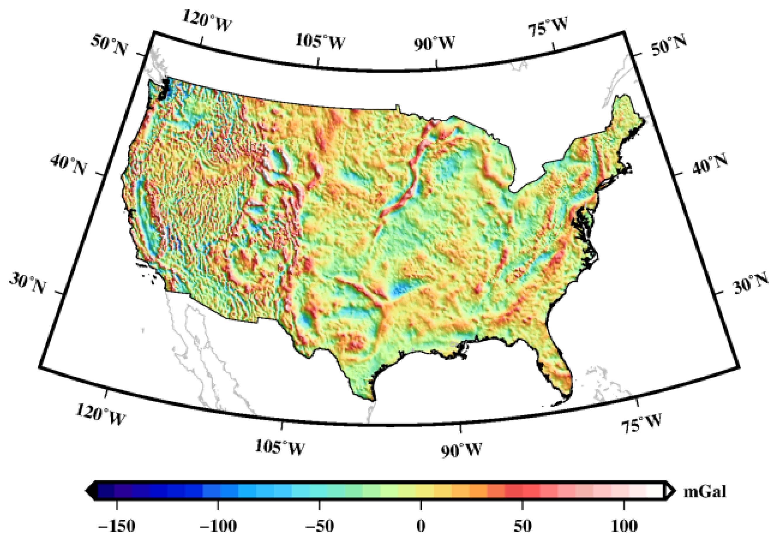
A total of 822,301 terrestrial gravity observations distributed in the United States were utilized, with the maximum, minimum, and mean values of 238.36 mGal (1 mGal = 10−5 m∙s−2), −234.24 mGal, and −6.03 mGal, respectively. The gravity data were gridded to enable processing by a fast Fourier transform method through the following steps: (a) Removal of the topographic effect through the Bouguer reduction. (b) Interpolation on a grid using Shepard’s surface fitting method. This method is a commonly employed technique for spatial interpolation, primarily due to its simplicity and ease of implementation. It involves calculating weighted averages of known data points to estimate values at unknown locations. Importantly, it exhibits independence from a specific data distribution, allowing for effective interpolation at any location within the study area. (c) Restoration of the topographic effect to the gridded Bouguer gravity anomalies. The gridded free-air gravity anomalies can be seen in Figure 2.

2.3. Topographic Data

Topographic data were utilized to calculate the short-wave topographic effect in geoid calculations. The digital elevation model used in this study was obtained from the Shuttle Radar Topography Mission (SRTM) model, with a spatial resolution of 3 arc seconds (approximately 90 m). The standard deviation (std) of the differences in SRTM DEM with respect to the best national DEM model was found to be 7.9 m [24]. The topographic data are presented in Figure 3a, while DTM2006.0 served as a high-pass filter to remove the long-wavelength features from the SRTM data, as shown in Figure 3b.
From Figure 3, it can be observed that the United States exhibits three distinct geographic regions: a predominantly plateau-dominated western region, a central region characterized by expansive plains, and an eastern region prominently dominated by mountains. The terrain showcases a rich diversity and complexity, with vast stretches of mountainous areas. From Table 1, it can be seen that the average elevation of the continental United States is approximately 780 m.

2.4. GGMs

Gravity anomalies over the United States were evaluated from several high-degree GGMs, namely the Earth Gravitational Model 2008 (EGM2008) [25], the European Improved Gravity model of the Earth by New techniques-6C4 (EIGEN-6C4) [26], and the Experimental Gravity Field Model 2019e (XGM2019e_2159) [27], via spherical harmonic expansions. EGM2008 is complete to degree and order 2159, with additional coefficients up to degree 2190 and order 2159. EIGEN-6C4 is a static global combined gravity field model up to degree and order 2190. XGM2019e_2159 is an experimental gravity field model up to spheroidal harmonic degree and order 2159 and spherical harmonic degree and order 2190. The gravity anomalies from these three high-degree GGMs are summarized in Table 1. The results show that the XGM2019e_2159 model exhibits the largest range of gravity anomaly.
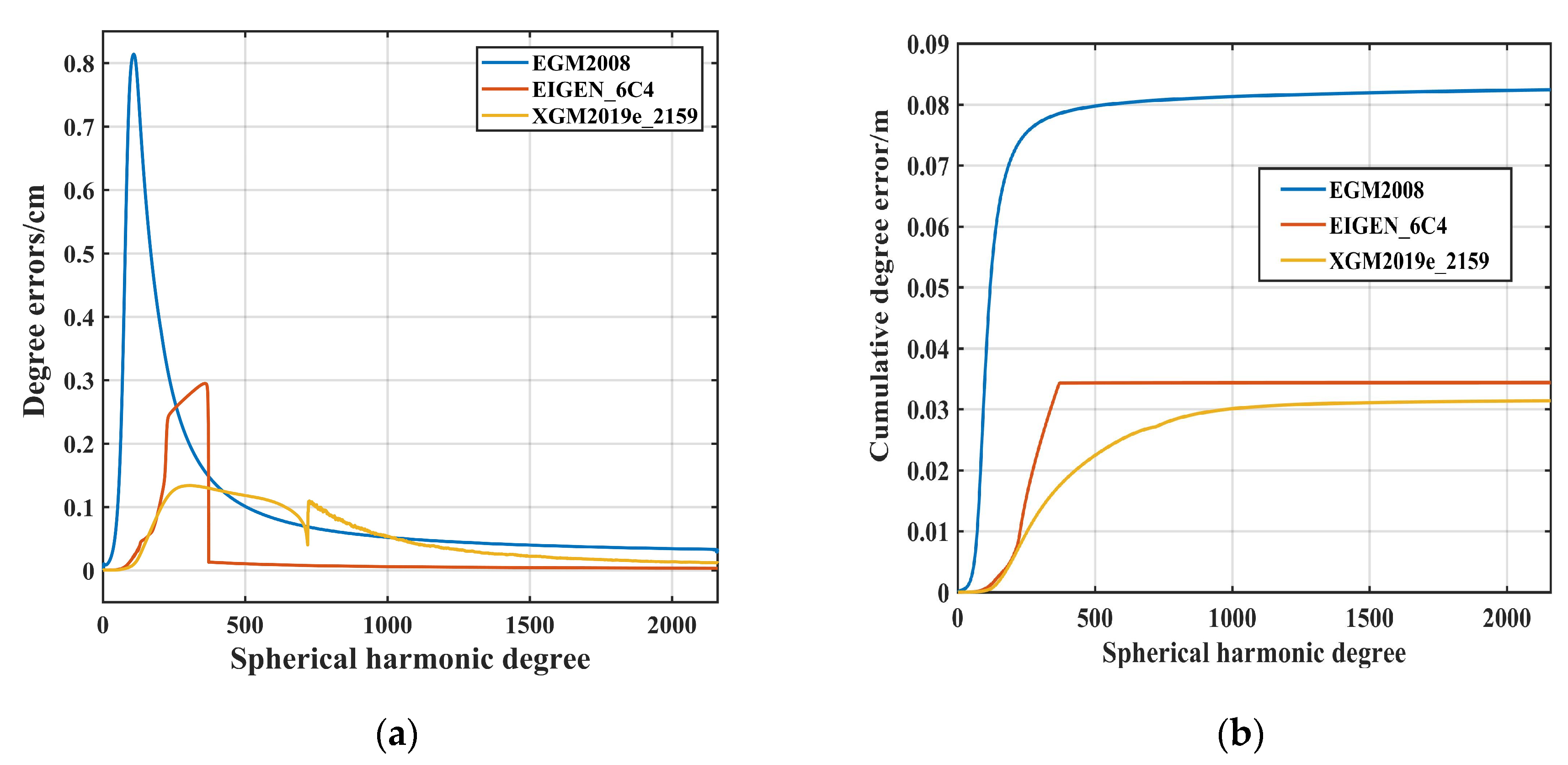
The degree error and cumulative degree error serve as crucial reference quantities for statistically analyzing and describing the spectral sensitivity of Earth’s gravity field. In Figure 4a, the degree errors of GGMs are depicted, providing insights into the inaccuracies of the potential coefficient. The EGM2008, EIGEN-6C4, and XGM2019e_2159 exhibit their maximum degree errors at degrees 108, 358, and 303, respectively, followed by a gradual decrease. Within the low-frequency range, the XGM2019e_2159 model demonstrates the smallest error, with EIGEN-6C4 following closely, while EGM2008 exhibits a comparatively larger error. Conversely, in the medium- to high-frequency range, the three GGMs exhibit similar precision. Figure 4b displays the cumulative degree errors of the GGMs. The XGM2019e_2159 model exhibits the smallest cumulative degree error among the three models. Moreover, the cumulative degree variances of the EGM2008, EIGEN-6C4, and XGM2019e_2015 models tend to stabilize after reaching approximately 350, 370, and 850 degrees, respectively, displaying minimal fluctuations.

3. Methods to Determine Vertical Datum Offset

The concepts of classical physical geodesy allow the geopotential differential to be written as
d W = W x d x + W y d y + W z d z = grad W d s = g d s = g d n
where W is the gravity potential, g is the magnitude of the gravity field vector, ds is the vectorial line element, and dn is the distance along the vertical. Equation (1) shows that gravimetric and geometric observations directly provide gravity potential differences, and the geopotential number C is given in the form
C = W 0 W P = - P 0 P d W = P 0 P g d n
where W 0 is a global geopotential value, P is a point on the Earth’s surface, and P0 is a point on the reference surface that is associated with a national tide gauge. As tide gauges are usually built as a starting point for regional vertical datum systems, there are inconsistencies between them.
The traditional method for obtaining geopotential differences involves a combination of gravity observations and geometric leveling. However, this technique is only practical for connecting adjacent vertical datums that can be linked via leveling. For vertical datums separated by oceans, GGMs offer a viable solution for unifying multiple local vertical datums [28,29]. There are two primary classes of methods based on GGMs for estimating the gravity geopotential difference: the geopotential difference approach and the GBVP approach. In the following sections, we describe the procedures for both methods to evaluate the vertical offset.

3.1. Geopotential Difference Approach

This approach is used to estimate the LVD zero-level geopotential value W 0 LVD based on the definitions of the Helmert orthometric heights or normal heights (see Figure 5). The orthometric (normal) heights are modeled by estimating the mean (normal) gravity using the Poincaré–Prey reduction [30] using
Δ H * = 1 γ ¯ 0 l W 0 W 0 LVD Δ H = 1 g ¯ 0 l W 0 W 0 LVD
where Δ H * is the vertical datum offset in the normal heights system, Δ H is the vertical datum offset in the orthometric heights system, γ ¯ 0 l is the mean normal gravity, and g ¯ 0 l is the mean gravity on the benchmarks that belong to the LVD.
The estimation of W 0 LVD relies on the spatial position for numerous leveling benchmarks, and a detailed representation of the GGM is
W 0 LVD = W P + H * γ ¯ = W P + H g ¯
where W P is the geopotential at point P, which can be computed from a GGM, H * is the normal height, represents the orthometric heights of the benchmarks with respect to the LVD, and γ ¯ is the mean normal gravity along the normal plumbline between the telluroid and reference ellipsoid. The value of γ ¯ is computed from a truncated (usually up to the 2nd term) latitude-dependent power series of the normal heights H * that incorporate the fundamental parameters of the normal gravity field. The g ¯ denotes the mean gravity along the physical plumb line.
Substituting W 0 LVD from Equation (4) into Equation (3) gives the offset between the LVD and global vertical datum as
Δ H * = 1 γ ¯ 0 l W 0 W P H * γ ¯ Δ H = 1 g ¯ 0 l W 0 W P H g ¯
If more than one LVD benchmark is used, then the previous approach leads to an averaging procedure to give an improved estimate.

3.2. GBVP Approach

Instead of computing the gravity potential at benchmarks, a geoid or quasi-geoid model can be used to recover the unknown parameter W 0 LVD . We study the case where orthometric heights are employed along the gravimetric geoid and ellipsoidal heights. In the absence of random or systematic errors, the ellipsoidal, orthometric, and gravimetric geoid heights at terrestrial benchmarks fulfill the theoretical constraint [15,16],
h H N = W 0 W 0 LVD γ
where γ is the normal gravity on the reference ellipsoid, h represents the ellipsoidal heights, and N is the geoid undulation at terrestrial benchmarks.
The gravity data Δ g on the global geoid are usually required to unify vertical datums. However, we can only obtain the gravity anomaly Δ g l on the equipotential surface of the zero-height level of the LVD. The relationship between the gravity anomaly Δ g and Δ g l can be expressed as
Δ g = Δ g l + 2 R δ W 0 LVD
where δ W 0 LVD is the potential difference between the local vertical datum and global geoid.
The disturbing potential is used instead of the potential as the fundamental target quantity. As the disturbing potential has the important property of being harmonic outside Earth’s surface, its solutions T are given in the framework of the GBVP and potential theory [22] as
T = δ G M R W 0 U 0 γ + R 4 π σ S ψ Δ g l + 2 R δ W 0 LVD d σ
where S ψ is Stokes’ function and σ is the unit sphere. It is assumed the normal potential of the reference ellipsoid U 0 differs from the geopotential of the global geoid W 0 and the gravitational constant of the Earth differs from the gravitational constant of the reference ellipsoid by δ G M .
The equation of the “geometric” geoid height is obtained using Bruns’ formula as
h H = δ G M R γ W 0 U 0 γ + δ W 0 LVD γ + R 4 π γ σ S ψ Δ g l d σ + 1 2 π γ σ δ W 0 LVD S ψ d σ
and
N 0 = δ G M R γ W 0 U 0 γ N m = R 4 π γ σ S ψ Δ g l d σ N ind = 1 2 π γ σ δ W 0 LVD S ψ d σ
where N 0 is the zero-degree term of the geoid height, N m is the gravimetric geoid [31], and the indirect bias term N ind [32] demonstrates a minimal influence, with a maximum effect of less than 1 cm for all potential coefficient values. Thus, it is deemed unnecessary to include the indirect bias term in practical height unification [33].
Inserting Equation (10) into Equation (9) provides
Δ H = h H N 0 N m
where Δ H is the vertical offset. If the normal height H * is used instead of the orthometric height H , and the height anomaly ζ m as calculated based on Molodensky theory is used instead of N m , then Equation (11) can be written as
Δ H * = h H N 0 ζ m

4. Some Issues Affecting LVD Offset Accuracy

4.1. Influence of the Ellipsoids

The normal geopotential U 0 of the reference ellipsoid reflects the Earth′s total mass, rotational angular velocity, and the shape of the ellipsoid [34]. Although the ellipsoidal parameters corresponding to different reference systems are not the same and their corresponding normal geopotentials U 0 are different, the U 0 is solely determined by four parameters of the ellipsoid: the geocentric gravitational constant GM (gravitational constant G times the mass of the Earth M), the angular velocity ω, Earth’s oblateness f (or dynamic form factor of the Earth J2), and the semi-major axis of a reference ellipsoid a [31]. Table 2 lists the basic parameters of commonly used geodetic reference systems, such as Geodetic Reference System 1980 (GRS80) and World Geodetic System 1984 (WGS84).

4.2. Gauss–Listing Geopotential Value

In geopotential space, a global potential value helps define the zero-height datum [7]. An intuitive value is the potential value of the Gauss–Listing geoid [35] which can be used to best represent the MSL. For implementation purposes, it is more practical to use the classical geoid defined by Gauss–Listing as the GVD [36].
Various numerical results for the mean geopotential value of the global mean sea surface, W MSS , have been calculated using global mean sea surface (MSS) height models and GGMs [37]. To improve accuracy, the DTU18MSS model incorporates a processing method and utilizes an updated version of the ocean tide model, namely the Finite Element Solution tidal model, thereby enhancing the accuracy of the calculations. In this study, we adopt the geopotential value of 62,636,846.628 m2s−2 obtained from the DTU18MSS model, as calculated by Amin et al. [8].

4.3. Parameter Transformations between the Ellipsoid and GGM

The geocentric gravitational constant G M and equatorial semi-diameter a used in the high-order GGMs differ from the ellipsoidal parameters of the geodetic reference system. Therefore, to compute gravity quantities relative to a specific reference ellipsoid, the GGM’s gravitational potential coefficients must be converted to the corresponding reference system:
C ¯ n , m R = C ¯ n , m M × G M M G M R a M a R n S ¯ n , m R = S ¯ n , m M × G M M G M R a M a R n
where the subscript M denotes the parameters of the GGM; the subscript R denotes the parameters of the reference ellipsoid.
Table 3 lists the parameters for three high-order GGMs used in this study: EGM2008, EIGEN-6C4, and XGM2019e_2159.

4.4. Contribution of the Zero-Order Term

The disturbing potential was determined at a given point on the geoid, but the geoid heights derived from the GBVP approach did not consider the zero-degree spherical harmonics. Therefore, the zero-order term for geoid undulation should be added to consider the difference between the Earth and reference ellipsoid geocentric gravitational constants, and the difference between the reference potential and normal potential on the reference ellipsoid. Bruns’ formula provides a way to calculate the zero-order term, which is given by
N 0 = G M M G M R R γ W 0 U 0 γ
The first term on the right-hand side of Equation (14) indicates the effect of the difference between the geocentric gravitational constant of the GGM and that of the reference ellipsoid, while the second term indicates the effect of differences between the reference potential W 0 and normal potential U 0 on the reference ellipsoid. However, the second term is neglected when assuming W 0 = U 0 . Table 4 gives the contributions of the first term due to different G M values on the N0. The effect of the different G M between the GRS80 and the selected GGMs is approximately 93.8 cm.

4.5. Influence of the Tidal Effects

In the process of unifying the vertical datum, tidal effects play a critical role and require consideration of two aspects.
Firstly, the second-degree zonal coefficient geopotential coefficient C ¯ 2 , 0 varies across various tide systems, such as the tide-free system, mean-tide system, and zero-tide system. In the tide-free system, the permanent deformation is eliminated from the geometric shape of the Earth. In the mean-tide system, the permanent effect on the Earth’s geometric shape is retained. In the zero-tide system, the potential field represents that of the “average Earth”. The gravity field is solely attributed to the masses of the Earth (plus the centrifugal force) [38].
To remove the total tidal effects, it is recommended to use a tide-free system for geopotential quantities based on the International Earth Rotation Service (IERS) 2010 convention [39]. Therefore, the C ¯ 2 , 0 coefficient of the GGM is converted from the zero-tide system to the tide-free system according to [40]:
C ¯ 2 , 0 TF = C ¯ 2 , 0 ZF + 3.1108 10 8 k 5
where C ¯ 2 , 0 TF is the spherical harmonic coefficient related to the tide-free system, C ¯ 2 , 0 ZF is the spherical harmonic coefficient related to the zero-tide system, and the Love number k is set to 0.3 for the Preliminary Reference Earth Model (PREM) [41].
Secondly, as parameters, observations, and data on GNSS benchmarks are related to the mean-tide system, the GNSS/leveling heights should be transformed from the mean-tide system to the tide-free system [42]. This conversion is given in
N TF = N MF 1 + k 0.099 0.296 sin 2 φ
where N TF represents the geoid heights related to the tide-free system, N MF represents the geoid heights related to the mean-tide system, and φ is the latitude of GNSS benchmarks. Figure 6 shows the variations of the difference between N TF and N MF with the latitude. As seen in Figure 6, the difference between N TF and N MF can reach 9.7 cm at a latitude of 50°.

4.6. Treatment of Omission Error

The EGM2008, EIGEN-6C4, and XGM2019_2159 models represent the most advanced high-degree global geopotential models of the Earth’s external gravity field, with a spatial resolution of 5 arc minutes. However, geoid heights and other gravity field quantities calculated solely from a truncated GGM series expansion may be affected by signal omission error [8].
To minimize this error, two common methods are employed in the GBVP approach. The first method is the remove–compute–restore (RCR) approach. In this method, GGM-implied gravity anomalies are subtracted from a set of terrestrial gravity observations, resulting in residual gravity anomalies. These residual gravity anomalies are then converted to residual height anomalies using Stokes’s formula and subsequently added to GGM-implied long-wavelength height anomalies.
The second method involves utilizing residual terrain model (RTM) data to model high-frequency gravity field signals [43], particularly in regions characterized by moderate elevation and rugged terrain. This is accomplished by eliminating the low-frequency components inherent in the DTM already accounted for by the GGM. The conversion of RTM elevations into RTM height anomalies is achieved through the implementation of forward-modeling gravitational potential formulas [44].
In this study, we employ a combination of the RCR approach and RTM to calculate the gravimetric geoid. First, the contributions of the GGM and terrain effects are removed from the free-air gravity anomaly. The residual gravity anomalies, within the framework of the RTM technique, are computed by
Δ g res = Δ g fa Δ g egm Δ g RTM
where Δ g fa represents the free-air anomalies, Δ g egm represents the gravity anomalies calculated with a selected GGM [45]; Δ g RTM is the effect of RTM correction on the gravity anomaly:
Δ g RTM = 2 π G ρ h h ref Δ g tc
where Δ g tc is the terrain correction and h ref is a low-degree spherical harmonic representation of the topography generated by a global DTM.
Finally, the contributions of the GGM and terrain effects are restored after Stokes’s integration:
N m = R 4 π γ σ Δ g res S ψ d σ + N egm + N RTM
where N egm is the reference geoidal undulation calculated from the GGM, and N RTM is the RTM height anomaly:
N RTM = G ρ h h ref γ 1 r d x d y
where r is the distance.

4.7. Treatment of Systematic Errors

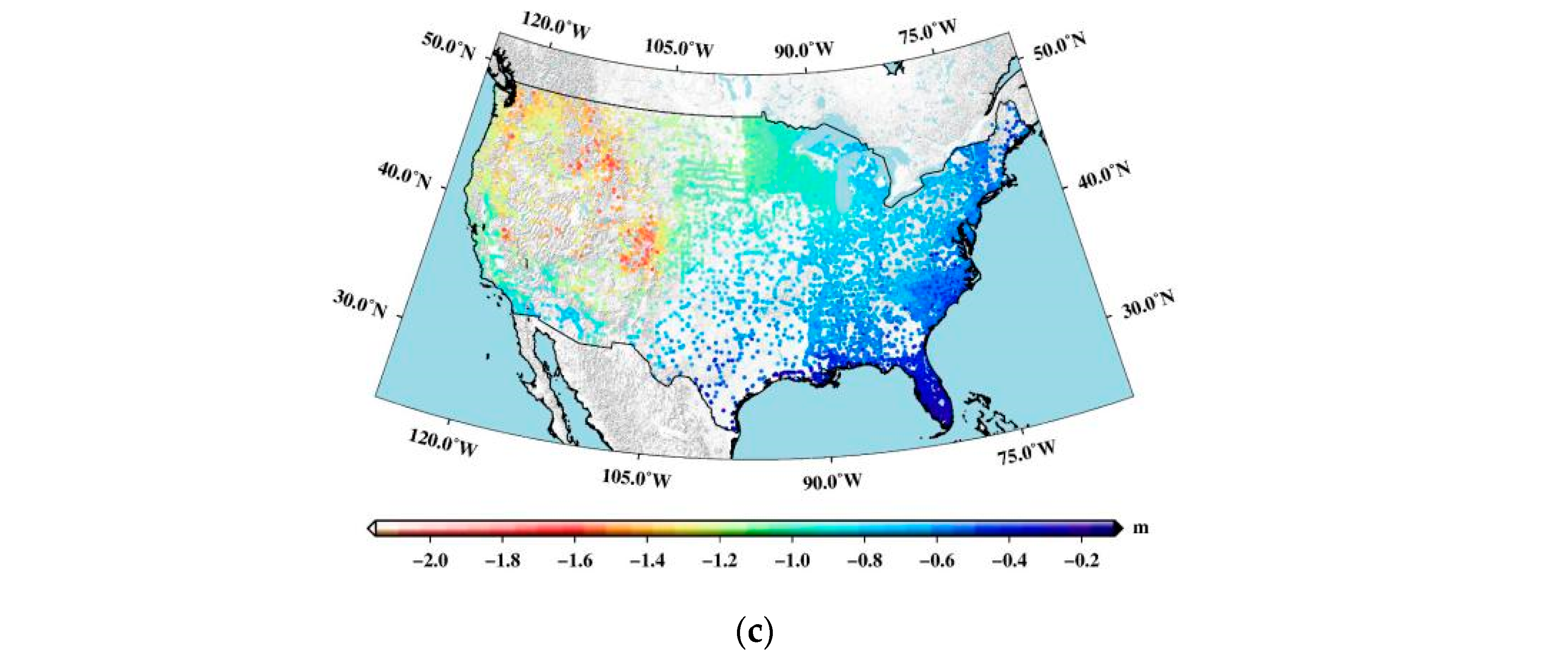
In the presence of systematic effects and spatially correlated errors in the height data, the least squares (LS) estimator from Equation (6) may yield a biased result due to improper data modeling. In such cases, the original h-H-N values do not follow a typical trend of a constant offset, but instead exhibit strong spatial tilts over the GNSS/leveling benchmarks. Figure 7 displays the height differences between GNSS/leveling data and gravimetric geoid heights computed based on EGM2008, EIGEN-6C4, and XGM2019e_2159. It reveals a significant northwest–southeast tilt in the GNSS benchmarks, which can be attributed to various types of systematic errors, such as geometrical distortions in the leveling data, long and medium wavelength errors in the geoid model, and datum inconsistencies between the ellipsoidal and the geoid heights.
To remove the systematic effects [18], an extended observation equation is used:
h H N = W 0 W 0 LVD γ + α φ φ 0 + β λ λ 0 cos φ
where φ and λ are the latitude and longitude of GNSS benchmarks, respectively; φ 0 and λ 0 are the latitude and longitude of the tide gauge, respectively; α is the parameter of the north–south (N–S) component; and β is the parameter of the east–west (E–W) component, which can be obtained by the least squares method, for which the results are listed in Table 5. The overall tilt amounts to about 103 cm in an E–W direction and up to about 69 cm in a N–S direction.

5. Results and Discussion

5.1. Results of Geopotential Difference Approach

If the normal potential U 0 of the ellipsoid is taken as the global geopotential value W 0 , this is W 0 = U 0 , and the vertical datum offset is obtained according to Equation (5). Potential values of several high-degree (up to 2190 order) GGMs, including the EGM2008 model, the EIGEN-6C4 model, and the XGM2019e_2159model, were obtained in order to compare them. The tide-free system was selected, and the commonly used GRS80 and WGS84 ellipsoids were used. Table 6 summarizes the zero-height geopotential W 0 LVD and its offsets from the global datum defined by U 0 .
We found geopotential differences of −0.422 m2s−2, −0.431 m2s−2, and −0.401 m2s−2 using the EGM2008, EIGEN-6C4, and XGM2019e_2159 models, respectively, relative to the GRS80 ellipsoid. Similarly, we found geopotential differences of −9.543 m2s−2, −9.552 m2s−2, and −9.533 m2s−2, respectively, using the same models relative to the WGS84 ellipsoid. The vertical offset values were consistent with each other and negative, indicating that the zero-height geopotential W 0 LVD is higher than the global datum defined by U 0 .
Alternatively, if we take the mean geopotential value of the global mean sea surface W MSS as the global geopotential value W 0 , this is W 0 = W MSS , and the geopotential difference and the datum offset can be obtained according to Equation (5); the results are presented in Table 7. Relative to the GRS80 ellipsoid, the zero height of North America differs from the global height datum defined by the mean sea surface by −1.454 m, −1.455 m, and −1.454 m, respectively, when calculated using the EGM2008, EIGEN-6C4, and XGM2019e_2159 models. Similarly, relative to the WGS84 ellipsoid, we found differences of −0.520 m, −0.521 m, and −0.520 m, respectively, using the same models.

5.2. Results of the GBVP Approach

The method for estimating the vertical datum offset using the GBVP approach involves subtracting the gravimetric geoid from the geometric height anomalies to obtain the offset between the local and global vertical datums. The gravimetric geoid is determined based on RTM data, acquired through the subtraction of the DTM2006.0 spherical harmonic expansion, representing Earth’s topography, from the SRTM3 DTM data. This procedure effectively acts as a high-pass filter, eliminating long-wavelength features from the SRTM3 data and yielding residual gravity anomalies, as described in Equation (18). Figure 8 illustrates these residual gravity anomalies, exhibiting a mean value of 0.54 mGal and a standard deviation of 0.78 mGal.
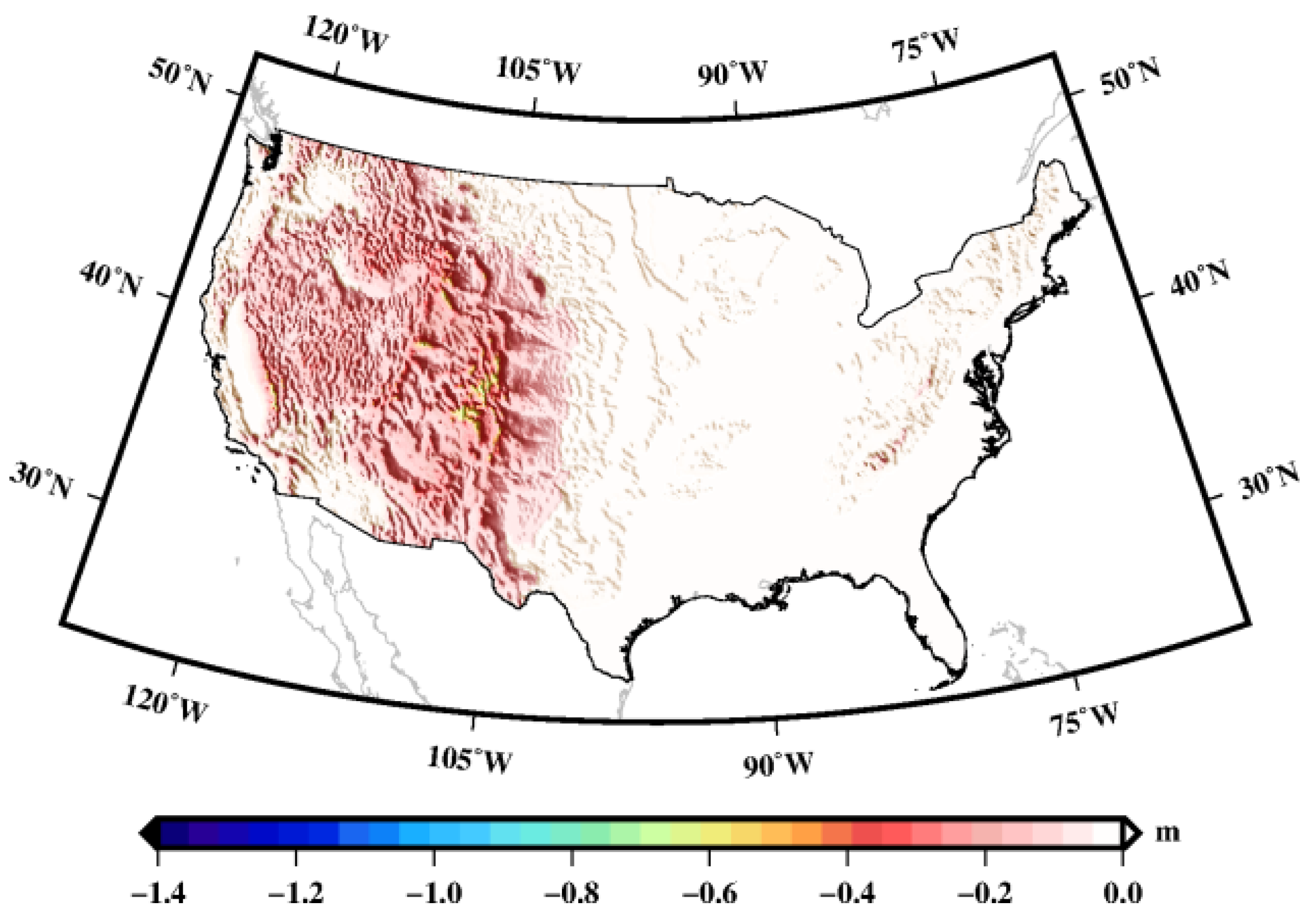
The RTM height anomalies are computed through the evaluation of residual elevations from the SRTM/DTM2006.0 dataset using Equation (20), as depicted in Figure 9. The mean and std values of the RTM height anomalies are −0.05 m and 0.08 m, respectively. The RTM height anomalies, along with the residual height anomalies computed from the residual gravity anomalies using Stokes’s integration, are added to the EGM2008 height anomalies to obtain the gravimetric geoid undulations. Using Equation (19), the gravimetric geoids are computed with the GGMs of EGM2008, EIGEN-6C4, and XGM2019e_2159.
By adopting the normal potential U 0 of the ellipsoid as the global geopotential value, the vertical datum offset is derived using Equation (11), and the corresponding results are presented in Table 8. For the GRS80 ellipsoid, the computed vertical offsets based on the EGM2008, EIGEN-6C4, and XGM2019e_2159 models are −0.045 m, −0.046 m, and −0.042 m, respectively. Similarly, for the WGS84 ellipsoid, the corresponding offsets are −0.977 m, −0.978 m, and −0.973 m, respectively. Remarkably, these values are in agreement with the results obtained from the geopotential difference approach.
If the geoid potential based on the DTU18MSS model, W MSS = 62,636,846.628 m2s−2, is taken as the global geopotential value W 0 , the difference between the reference potential W 0 value and the normal potential U 0 on the reference ellipsoid (i.e., the second term on the right-hand side of Equation (14)) must be considered when calculating the zero-order term, due to the effect of W MSS U 0 . The zero-height geopotential W 0 LVD and its offsets from the global datum defined by W MSS are listed in Table 9. The results show that, relative to the GRS80 ellipsoid, the zero height of North America differs from the global height datum defined by the mean sea surface by −1.455 m, −1.456 m, and −1.455 m, respectively, when calculated using the EGM2008, EIGEN-6C4, and XGM2019e_2159 models. Similarly, the zero height of North America differs by −0.522 m with respect to the WGS84 ellipsoid. These results obtained using the geopotential difference approach and the GBVP approach are consistent with each other.
In a previous study, Burša et al. [46] reported a geopotential value of 62,636,861.51 m2s−2 for NAVD88, which closely aligns with our value of 62,636,860.87 m2s−2 relative to GRS80, with a difference of less than 1 m2s−2. Amjadiparvar et al. [47] determined a vertical offset of −47.5 cm for NAVD88 in relation to W 0 = 62,636,856.0 m2s−2. This indicates that their geopotential value relative to GRS80 is approximately 62,636,860.6 m2s−2, demonstrating significant concurrence with our results.

6. Conclusions

Estimating the zero-height geopotential level of the LVD is a critical task in connecting isolated physical height frames and unifying them into a common vertical reference system. This paper studies the estimation scheme based on the joint inversion of co-located GNSS and leveling heights in conjunction with a fixed Earth gravity field model. Several case studies with real data are presented to provide precise estimates of the LVD offsets for the North America. The following conclusions are drawn from numerical analyses:
(1)
The different methods for unifying the local and global vertical datums are explained. The datum offsets between different vertical datums are defined as the ratio of the geopotential difference to the mean gravity or mean normal gravity. The numerical results demonstrate that the discrepancy between the results obtained by different methods is negligible.
(2)
To estimate the vertical offset, it is necessary to consider the effects of the parameters of reference ellipsoids, the contribution of the zero-order term, the tide system, and the tilt error. Analysis shows that the effect caused only by the difference in geopotential values between GRS80 and the selected GGMs is approximately 93.8 cm. The difference in geoid heights related to the tide-free system and the mean-tide system reaches 9.7 cm at a latitude of 50°. In the presence of systematic effects and spatially correlated errors in height data, there is a significant northwest–southeast tilt in the differences between the GNSS/leveling data and gravimetric geoid heights, with an overall tilt of approximately 103 cm in the E–W direction and 69 cm in the N–S direction.
(3)
Theoretical derivation and numerical analysis indicate that the results of the vertical offsets as calculated through the geopotential approach and GBVP approach are consistent. When selecting the normal gravity geopotential of the geodetic reference system U 0 as the gravity geopotential of the global height datum W 0 , the NAVD is greater than the GVD by approximately 0.04 m with reference to the GRS80 ellipsoid and by about 0.97 m with reference to the WGS84 ellipsoid. When selecting the Gauss–Listing geopotential value W MSS as the gravity geopotential of the global height datum W 0 , the NAVD is approximately 1.45 m higher than the GVD with reference to the GRS80 reference ellipsoid and approximately 0.52 m with reference to the WGS84 ellipsoid.

Author Contributions

Conceptualization, D.G. and Z.X.; methodology, D.G.; validation, D.G.; formal analysis, D.G.; software, D.G.; investigation, D.G.; resources, D.G.; data curation, D.G.; writing—original draft preparation, D.G.; writing—review and editing, D.G. and Z.X.; visualization, D.G. and Z.X.; supervision, D.G.; funding acquisition, D.G.; project administration, D.G. All authors have read and agreed to the published version of the manuscript.

Funding

This work is funded by the Basic Frontier Science Research Program of Chinese Academy of Sciences (No. ZDBS-LY-DQC028).

Data Availability Statement

The EGM2008, EIGEN-6C4, and XGM2019e_2159 global gravity field models are available at http://icgem.gfz-potsdam.de/tom_longtime (accessed on 24 August 2009, 2 December 2014, and 25 September 2019, respectively.). GNSS/leveling data are available at https://geodesy.noaa.gov/GEOID/GEOID18/downloads.shtml (accessed on 15 June 2009).

Acknowledgments

We express our gratitude to the National Geodetic Survey (NGS) for generously providing us with the GNSS/leveling data. We also extend our thanks to the International Centre for Global Earth Models (ICGEM) and NASA Shuttle Radar Topographic Mission (SRTM) for their kind provision of the Global Geopotential Models and the digital terrain model data, respectively. The authors are sincerely appreciative of the diligent review efforts of the anonymous reviewers, whose contributions significantly improved the quality of this work.

Conflicts of Interest

The authors declare no conflict of interest.

References

  1. Featherstone, W.E. Attempts to unify the Australian height datum between the Mainland and Tasmania. Vert. Ref. Syst. 2002, 124, 328–333. [Google Scholar]
  2. Filmer, M.S.; Hughes, C.W.; Woodworth, P.L.; Featherstone, W.E.; Bingham, R.J. Comparison between geodetic and oceanographic approaches to estimate mean dynamic topography for vertical datum unification: Evaluation at Australian tide gauges. J. Geod. 2018, 92, 1413–1437. [Google Scholar] [CrossRef] [Green Version]
  3. Slobbe, D.C.; Klees, R.; Verlaan, M.; Zijl, F.; Alberts, B.; Farahani, H.H. Height system connection between island and mainland using a hydrodynamic model: A case study connecting the Dutch Wadden islands to the Amsterdam ordnance datum (NAP). J. Geod. 2018, 92, 1439–1456. [Google Scholar] [CrossRef] [PubMed] [Green Version]
  4. Dilkoski, D.B. Results of the General Adjustment of the North American Vertical Datum of 1988. Surv. Land Inf. Syst. 1992, 52, 133–149. [Google Scholar]
  5. Smith, D.A.; Véronneau, M.; Roman, D.R.; Huang, J.; Sideris, M.G. Towards the Unification of the Vertical Datum Over the North American Continent; Springer: Berlin/Heidelberg, Germany, 2013. [Google Scholar]
  6. Ardalan, A.A.; Safari, A. Global height datum unification: A new approach in gravity potential space. J. Geod. 2005, 79, 512–523. [Google Scholar] [CrossRef]
  7. Sánchez, L.; Dayoub, N.; Čunderlík, R.; Minarechová, Z.; Šíma, Z. W0 Estimates in the Frame of the GGOS Working Group on Vertical Datum Standardisation; Springer International Publishing: Berlin/Heidelberg, Germany, 2014. [Google Scholar]
  8. Amin, H.; Sjoberg, L.E.; Bagherbandi, M. A global vertical datum defined by the conventional geoid potential and the Earth ellipsoid parameters. J. Geod. 2019, 93, 1943–1961. [Google Scholar] [CrossRef] [Green Version]
  9. Rummel, R. Global Integrated Geodetic and Geodynamic Observing System (GIGGOS). In Towards an Integrated Global Geodetic Observing System (IGGOS); Springer: Berlin/Heidelberg, Germany, 2000; Volume 120, pp. 253–260. [Google Scholar]
  10. Ihde, J.; Adam, J.; Gurtner, W.; Harsson, B.G.; Wppelmann, G. The Height Solution of the European Vertical Reference Network (EUVN). Veröff. Bayer. Komm. Für Die Internat. Erdmess. Astronom. Geod. Arb 2002, 61, 132–145. [Google Scholar]
  11. Rangelova, E.; Fotopoulos, G.; Sideris, M.G. Implementing a Dynamic Geoid as a Vertical Datum for Orthometric Heights in Canada. Gravity Geoid Earth Obs. 2010, 135, 295–302. [Google Scholar]
  12. Thompson, K.R.; Huang, J.; Véronneau, M.; Wright, D.G.; Lu, Y. Mean surface topography of the northwest Atlantic: Comparison of estimates based on satellite, terrestrial gravity, and oceanographic observations. J. Geophys. Res. 2009, 114. [Google Scholar] [CrossRef] [Green Version]
  13. Woodworth, P.L.; Hughes, C.W.; Bingham, R.J.; Gruber, T. Towards worldwide height system unification using ocean information. J. Geodetic Sci. 2011, 365, 2. [Google Scholar] [CrossRef] [Green Version]
  14. Bao, L.F.; Xu, H.Z.; Li, Z.C. Towards a 1 mGal accuracy and 1 min resolution altimetry gravity field. J. Geod. 2013, 87, 961–969. [Google Scholar] [CrossRef]
  15. Kotsakis, C.; Katsambalos, K.; Ampatzidis, D. Estimation of the zero-height geopotential level W0 LVDin a local vertical datum from inversion of co-located GPS, leveling and geoid heights: A case study in the Hellenic islands. J. Geod. 2012, 86, 423–439. [Google Scholar] [CrossRef]
  16. Tocho, C.; Vergos, G.S. Estimation of the Geopotential Value W0 for the Local Vertical Datum of Argentina Using EGM2008 and GPS/Levelling Data W0LVD. In IAG 150 Years; Springer: Berlin/Heidelberg, Germany, 2016; Volume 143, pp. 271–279. [Google Scholar]
  17. Bursa, M.; Kenyon, S.; Kouba, J.; Radej, K.; Vatrt, V.; Vojtiskova, M.; Simek, J. World height system specified by geopotential at tide gauge stations. Vert. Ref. Syst. 2002, 124, 291–296. [Google Scholar]
  18. Hayden, T.; Rangelova, E.; Sideris, M.G.; Véronneau, M. Evaluation of W0 in Canada using tide gauges and GOCE gravity field models. J. Geodetic Sci. 2012, 2, 290–301. [Google Scholar] [CrossRef]
  19. Grigoriadis, V.N.; Lambrou, E.; Vergos, G.S.; Tziavos, I.N. Assessment of the Greek Vertical Datum: A Case Study in Central Greece. In Proceedings of the International Symposium on Gravity, Geoid and Height Systems 2016: Proceedings Organized by IAG Commission 2 and the International Gravity Field Service, Thessaloniki, Greece, 19–23 September 2016; Springer International Publishing: Berlin/Heidelberg, Germany, 2019; pp. 185–191. [Google Scholar]
  20. Zhang, L.M.; Li, F.; Chen, W.; Zhang, C.Y. Height datum unification between Shenzhen and Hong Kong using the solution of the linearized fixed-gravimetric boundary value problem. J. Geod. 2009, 83, 411–417. [Google Scholar] [CrossRef]
  21. Gerlach, C.; Rummel, R. Global height system unification with GOCE: A simulation study on the indirect bias term in the GBVP approach. J. Geod. 2013, 87, 57–67. [Google Scholar] [CrossRef]
  22. Amjadiparvar, B.; Rangelova, E.; Sideris, M.G. The GBVP approach for vertical datum unification: Recent results in North America. J. Geod. 2016, 90, 45–63. [Google Scholar] [CrossRef]
  23. Shum, C.K.; Tapley, B.D.; Yuan, D.N.; Ries, J.C.; Schutz, B.E. An Improved Model for the Earth’s Gravity Field; The Ohio State University: Columbus, OH, USA, 1988. [Google Scholar]
  24. Denker, H. Evaluation of SRTM3 and GTOPO30 terrain data in Germany. In Gravity Geoid Space Mission; Springer: Berlin/Heidelberg, Germany, 2005; Volume 129, pp. 218–223. [Google Scholar]
  25. Pavlis, N.K.; Holmes, S.A.; Kenyon, S.C.; Factor, J.K. The development and evaluation of the Earth Gravitational Model 2008 (EGM2008). J. Geophys. Res.-Solid Earth 2012, 117. [Google Scholar] [CrossRef] [Green Version]
  26. Kosteleck, J.; Jaroslav, K.; Bucha, B.; Ale, B.; Frste, C. Evaluation of gravity field model EIGEN-6C4 by means of various functions of gravity potential, and by GNSS/levelling. Geoinformatics FCE CTU 2015, 14, 7. [Google Scholar] [CrossRef] [Green Version]
  27. Zingerle, P.; Pail, R.; Gruber, T.; Oikonomidou, X. The combined global gravity field model XGM2019e. J. Geod. 2020, 94, 66. [Google Scholar] [CrossRef]
  28. Grombein, T.; Seitz, K.; Heck, B. On High-Frequency Topography-Implied Gravity Signals for a Height System Unification Using GOCE-Based Global Geopotential Models. Surv. Geophys. 2017, 38, 443–477. [Google Scholar] [CrossRef]
  29. Turchette, Q.A.; Kielpinski, D.; King, B.E.; Leibfried, D.; Meekhof, D.M.; Myatt, C.J.; Rowe, M.A.; Sackett, C.A.; Wood, C.S.; Itano, W.M.; et al. Heating of trapped ions from the quantum ground state. Phys. Rev. A. 2000, 61, 063418. [Google Scholar] [CrossRef] [Green Version]
  30. Heiskanen, W.A.; Moritz, H. Physical Geodesy; W.H. Freeman and Company: San Francisco, CA, USA, 1967. [Google Scholar]
  31. Andersen, O.B.; Fotopolous, G.; Pavlis, N.K.; Sansò, F.; Tziavos, I.N. Geoid Determination: Theory and Methods; Springer Science & Business Media: Berlin/Heidelberg, Germany, 2013. [Google Scholar]
  32. Tenzer, R.; Vanicek, P.; Novak, P. Far-zone contributions to topographical effects in the Stokes-Helmert method of the geoid determination. Stud. Geophys. Geod. 2003, 47, 467–480. [Google Scholar] [CrossRef]
  33. Gatti, A.; Reguzzoni, M.; Venuti, G. The height datum problem and the role of satellite gravity models. J. Geod. 2013, 87, 15–22. [Google Scholar] [CrossRef]
  34. Sanso, F.; Venuti, G. The height datum/geodetic datum problem. Geophys. J. Int. 2002, 149, 768–775. [Google Scholar]
  35. Dayoub, N.; Edwards, S.J.; Moore, P. The Gauss–Listing geopotential value W0 and its rate from altimetric mean sea level and GRACE. J. Geod. 2012, 86, 681–694. [Google Scholar] [CrossRef]
  36. Heck, B. Problems in the Definition of Vertical Reference Frames. In V Hotine-Marussi Symposium on Mathematical Geodesy; Springer: Berlin/Heidelberg, Germany, 2004. [Google Scholar]
  37. Sun, W.; Zhou, X.; Yang, L.; Zhou, D.; Li, F. Construction of the Mean Sea Surface Model Combined HY-2A With DTU18 MSS in the Antarctic Ocean. Front. Environ. Sci. 2021, 9, 697111. [Google Scholar] [CrossRef]
  38. Mäkinen, J. The permanent tide and the International Height Reference Frame IHRF. J. Geodesy. 2021, 95, 106. [Google Scholar] [CrossRef]
  39. Petit, G.; Luzum, B. IERS Conventions (2010); IERS Technical Note. US Naval Observatory: Washington, DC, USA, 2010. [Google Scholar]
  40. Rapp, R.H.; Wang, Y.M.; Pavlis, N.K. The Ohio State University Geopotential and sea Surface Topography Harmonic Coefficient Models; Department of Geodedic Sciences and Surveying, The Ohio State University: Columbus, OH, USA, 1991. [Google Scholar]
  41. Xiao, N.Y.; Xia, X.F. Love numbers calculated with PREM. Acta Geodaetica Et Cartographic Sinica. 1998, 27, 246–251. (In Chinese) [Google Scholar]
  42. Rülke, A.; Liebsch, G.; Sacher, M.; Schäfer, U.; Schirmer, U.; Ihde, J. Unification of European height system realizations. J. Geodetic Sci. 2012, 2, 343–354. [Google Scholar] [CrossRef]
  43. Hirt, C.; Marti, U.; Bürki, B.; Featherstone, W.E. Assessment of EGM2008 in Europe using accurate astrogeodetic vertical deflections and omission error estimates from SRTM/DTM2006.0 residual terrain model data. J. Geophys. Res. 2010, 115, B10404. [Google Scholar] [CrossRef] [Green Version]
  44. Hwang, C.; Hsu, H.J.; Featherstone, W.E.; Cheng, C.C.; Yang, M.; Huang, W.S.; Wang, C.Y.; Huang, J.F.; Chen, K.H.; Huang, C.H.; et al. New gravimetric-only and hybrid geoid models of Taiwan for height modernisation, cross-island datum connection and airborne LiDAR mapping. J. Geod. 2020, 94, 83. [Google Scholar] [CrossRef]
  45. Novák, P.; Kostelecký, J.; Klokočník, J. Testing global geopotential models through comparison of a local quasi-geoid model with GPS/leveling data. Stud. Geophys. Geod. 2009, 53, 39. [Google Scholar] [CrossRef]
  46. Burša, M.; Kouba, J.; Müller, A.; Raděj, K.; True, S.A.; Vatrt, V.; Vojtíšková, M. Determination of geopotential differences between local vertical datums and realization of a world height system. Stud. Geophys. Geod. 2001, 45, 127–132. [Google Scholar] [CrossRef]
  47. Amjadiparvar, B.; Rangelova, E.V.; Sideris, M.G.; Véronneau, M. North American height datums and their offsets: The effect of GOCE omission errors and systematic levelling effects. J. Appl. Geodesy. 2013, 7, 39–50. [Google Scholar] [CrossRef]
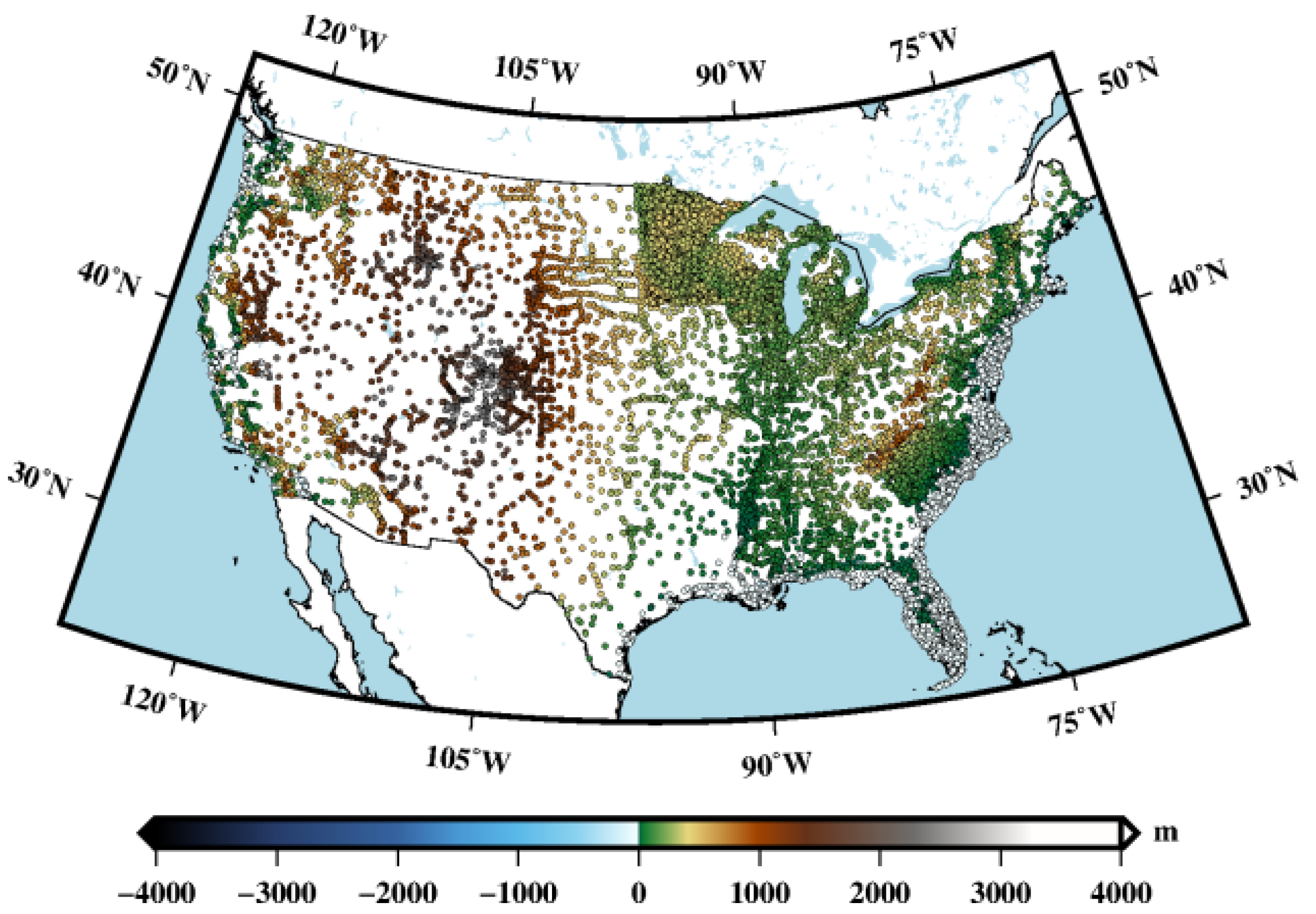
Figure 1. Distribution of the GNSS benchmarks (the color of the dots represents the elevation of the GNSS benchmarks).
Remotesensing 15 03610 g001
Figure 2. Gridded free-air gravity anomalies.
Remotesensing 15 03610 g002
Figure 3. Topographic data of (a) SRTM model and (b) DTM2006.0 model.
Remotesensing 15 03610 g003
Figure 4. (a) Degree error and (b) cumulative degree error of GGMs.
Remotesensing 15 03610 g004
Figure 5. Heights and reference surfaces.
Remotesensing 15 03610 g005
Figure 6. Difference between N TF and N MF with the latitude.
Remotesensing 15 03610 g006
Figure 7. Differences between the GNSS/leveling data and gravimetric geoid heights computed with GGMs of (a) EGM2008, (b) EIGEN-6C4, and (c) XGM2019e_2159.
Remotesensing 15 03610 g007aRemotesensing 15 03610 g007b
Figure 8. Residual gravity anomalies.
Remotesensing 15 03610 g008
Figure 9. RTM height anomalies.
Remotesensing 15 03610 g009
Table 1. Statistics of the input data.
ModelsMaxMinMeanStd
GNSS/leveling heights (m)−7.45−38.96−27.636.07
SRTM (m)4276.21−484.52777.69728.08
DTM2006.0 (m)3807.24−622.36779.83722.11
terrestrial gravity (mGal)238.36−234.24−6.0329.21
Gravity anomalies (mGal)EGM2008246.61−170.352.5228.85
EIGEN-6C4248.59−170.872.5328.89
XGM2019e_2159252.42−175.262.5228.42
Table 2. Basic parameters of the geodetic reference systems.
Reference Systemsa/m1/fGM/m3s−2U0/m2s−2J2/×10−3
GRS806,378,137298.2572221013.986005000 × 101462,636,860.85000.484166854896119
WGS846,378,137298.2572235633.986004418 × 101462,636,851.71460.484166774983522
Table 3. Parameters of the GGMs.
GGMsa/m C ¯ 2 , 0 G M Tide System
EGM20086,378,136.30−0.4841651437908150 × 10−33.986004415 × 1014tide-free
−0.4841693173669740 × 10⁻³zero-tide
EIGEN-6C46,378,136.46−0.4841652170610000 × 10−33.986004415 × 1014tide-free
XGM2019e_21596,378,136.30−0.4841694947475625 × 10−33.986004415 × 1014zero-tide
Table 4. Zero-degree term due to the different G M values. Unit: m.
Reference
Systems
EGM2008EIGEN-6C4XGM2019e_2159
GRS80−0.938−0.938−0.938
WGS84−0.005−0.005−0.005
Table 5. Statistics of tilt error and overall tilt.
GGMs UsedTilt Error in an E–W Direction (m/°)Tilt Error in a N–S Direction
(m/°)
Overall Tilt in an E–W Direction
(m)
Overall Tilt in a N–S Direction
(m)
EGM20080.0280.0181.030.69
EIGEN-6C40.0280.0181.030.69
XGM2019e_21590.0260.0181.030.64
Table 6. The zero-height geopotential W 0 LVD and its offsets from the global datum defined by U 0 with the geopotential difference approach.
GGMsReference Systems W 0 LVD Geopotential
Difference (m2s−2)
Vertical
Offset (m)
EGM2008GRS8062,636,861.272−0.422−0.043
WGS8462,636,861.258−9.543−0.975
EIGEN-6C4GRS8062,636,861.281−0.431−0.044
WGS8462,636,861.267−9.552−0.976
XGM2019e_2159GRS8062,636,861.271−0.401−0.041
WGS8462,636,861.258−9.533−0.974
Table 7. Geopotential differences and vertical datum offsets of the zero heights W 0 LVD from the global datum defined by W MSS with the geopotential difference approach.
GGMsReference SystemsGeopotential
Difference (m2s−2)
Vertical
Offset (m)
EGM2008GRS80−14.229−1.454
WGS84−5.093−0.520
EIGEN-6C4GRS80−14.231−1.455
WGS84−5.094−0.521
XGM2019e_2159GRS80−14.229−1.454
WGS84−5.093−0.520
Table 8. Zero-height geopotential W 0 LVD and its offsets from the global datum as defined by U 0 with the GBVP approach. Unit: m.
GGMsReference SystemsMaxMinMeanStd
EGM2008GRS800.385−1.094−0.0450.067
WGS84−0.547−2.026−0.9770.067
EIGEN-6C4GRS800.380−1.097−0.0460.068
WGS84−0.552−2.030−0.9780.068
XGM2019e_2159GRS800.456−1.178−0.0420.071
WGS84−0.476−2.110−0.9730.071
Table 9. Zero-height geopotential W 0 LVD and its offsets from the global datum as defined by W MSS with the GBVP approach.
GGMsReference Systems W 0 LVD
(m2s−2)
Geopotential
Difference (m2s−2)
Vertical
Offset (m)
EGM2008GRS8062,636,860.875−14.249−1.455
WGS8462,636,851.741−5.113−0.522
EIGEN-6C4GRS8062,636,860.877−14.247−1.456
WGS8462,636,851.740−5.112−0.522
XGM2019e_2159GRS8062,636,860.875−14.247−1.455
WGS8462,636,851.740−5.112−0.522
Disclaimer/Publisher’s Note: The statements, opinions and data contained in all publications are solely those of the individual author(s) and contributor(s) and not of MDPI and/or the editor(s). MDPI and/or the editor(s) disclaim responsibility for any injury to people or property resulting from any ideas, methods, instructions or products referred to in the content.