
Local Climate Zone Classification by Seasonal and Diurnal Satellite Observations: An Integration of Daytime Thermal Infrared Multispectral Imageries and High-Resolution Night-Time Light Data


Abstract
1. Introduction
2. Materials and Methods
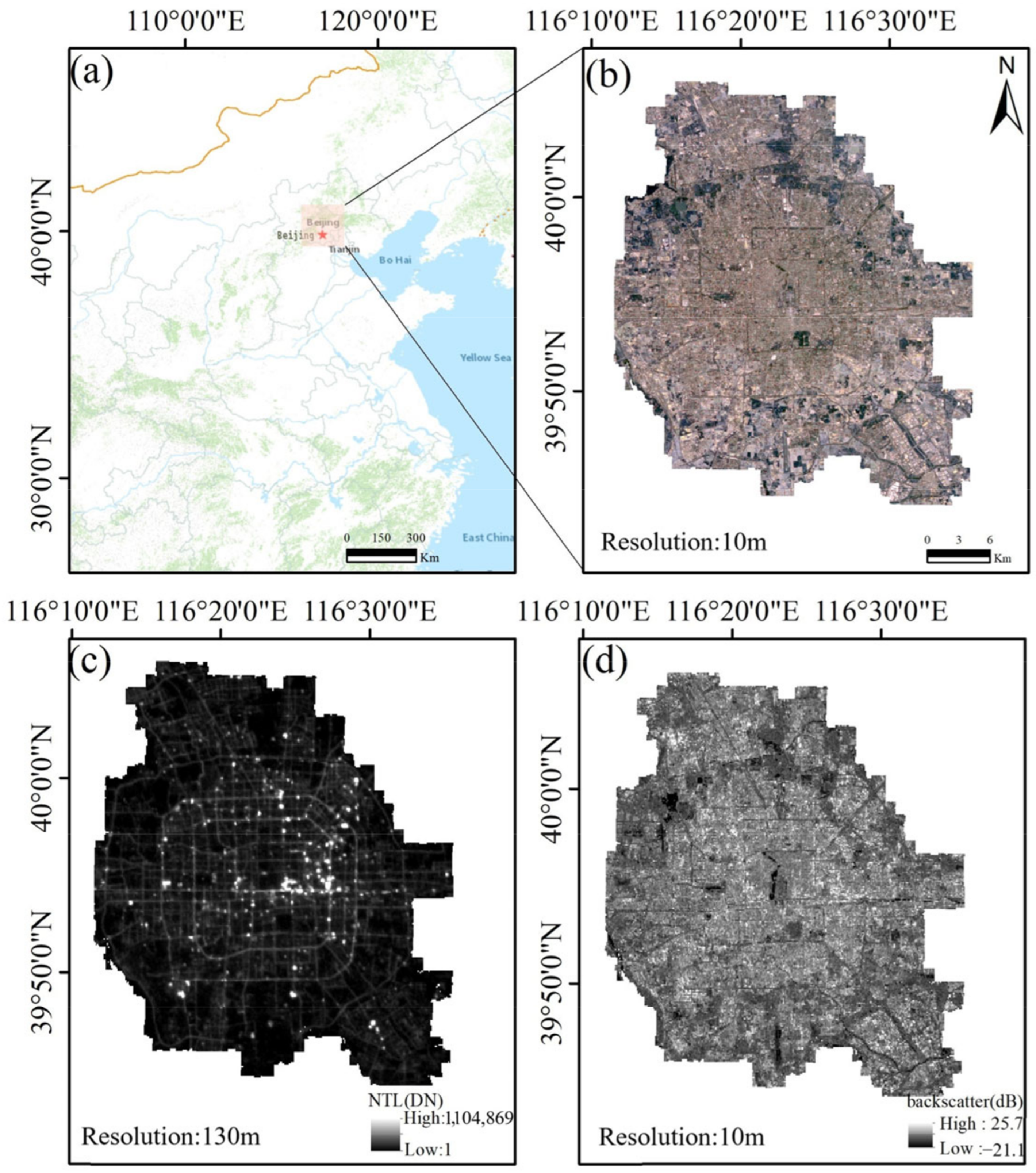
2.1. Study Area
2.2. Data
- Sentinel-1 Synthetic aperture radar:
- Sentinel-2 Multispectral Instrument:
- Night-time light data:
- Landsat-8 Operational Land Imager data:
2.3. Overview of the Approach
2.4. Sample Preparation
- A sample of N observations is taken with replacement from a dataset. Each observation consists of M attributes;
- When constructing a decision tree, m attributes are randomly chosen from the M attributes at each node, where . Then, one attribute is selected from the m attributes using a chosen splitting criterion;
- The decision tree is constructed by recursively splitting each node using the selected attribute until it cannot be split any further;
- Repeat steps 1–3 to construct a large number of decision trees, which form the random forest.
2.5. Multi-Feature Extraction
2.6. Feature Optimization
2.7. The Chosen Classifier
2.8. Experimental Design
2.9. Classification Accuracy Evaluation
3. Results
3.1. Results of Feature Optimization
3.2. Results of LCZ Labeling
3.3. The Consequence of Surface Thermal Properties on LCZ Mapping
3.4. The Distinctive Role of Night-Time Observations in LCZ Mapping
4. Discussion
4.1. How Does Surface Roughness Impact the LCZ Classification?
4.1.1. The Advantages of DEM for the Classification
4.1.2. The Advantages of Backscatter for the Classification
4.2. Synergetic Use of Leaf-On and -Off Imageries
4.3. Comparison with Considerable Methods
5. Conclusions
- The present method yielded excellent classification accuracy with an OA value of 88.86%. LCZ 3 (compact low-rise) had the best classification result, with PA and UA values exceeding 93%. LCZ F (bare soil or sand) with PA value = 86.6% and OA value = 87.7% yielded the worst classification effect. The total night-time light index (TNLI) exerted the most considerable influence on the LCZ partition and reached the highest GI value of 0.083. Backscatter in leaf-on seasons (LN_BS, GI value = 0.029) and backscatter in leaf-off seasons (LF_BS, GI value = 0.025) were found significantly affect LCZ classification;
- The accuracies of LCZs 1–9 were considerably increased when using the LST feature. Among these, the accuracy of LCZ 3 (compact low-rise) significantly increased by 16.10%. NTL largely contributed to the classification concerning LCZ 3 (compact low-rise) and LCZ A/B (dense trees). DEM can significantly improve the accuracies of classifications regarding LCZs 1–6 (compact and open buildings) and LCZ A/B (dense trees). In contrast, DEM did not help the classifications concerning LCZ 8 (large low-rise) and LCZs C-G;
- LCZs 1–6 (compact and open buildings) using BFC with backscatter yielded higher classification accuracy than those using BFC without backscatter. In addition, the performance of integrating leaf-on and -off imageries was better than the single use of any of those (the OA value increased by 4.75% compared with the single use of leaf-on imagery and 3.62% compared with that of leaf-off imagery).
Supplementary Materials
Author Contributions
Funding
Data Availability Statement
Acknowledgments
Conflicts of Interest
References
- Cao, S.S.; Weng, Q.H.; Lu, L.L. Distinctive roles of two- and three-dimensional urban structures in surface urban heat islands over the conterminous United States. Urban Clim. 2022, 44, 101230. [Google Scholar] [CrossRef]
- Dong, P.; Jiang, S.D.; Zhan, W.F.; Wang, C.L.; Miao, S.Q.; Du, H.L.; Li, J.F.; Wang, S.S.; Jiang, L. Diurnally continuous dynamics of surface urban heat island intensities of local climate zones with spatiotemporally enhanced satellite-derived land surface temperatures. Build. Environ. 2022, 218, 109105. [Google Scholar] [CrossRef]
- Cao, S.S.; Cai, Y.L.; Du, M.Y.; Weng, Q.H.; Lu, L.L. Seasonal and diurnal surface urban heat islands in China: An investigation of driving factors with three-dimensional urban morphological parameters. GISci. Remote Sens. 2022, 59, 1121–1142. [Google Scholar] [CrossRef]
- Stewart, I.D.; Oke, T.R. Local climate zones for urban temperature studies. Bull. Am. Meteorol. Soc. 2012, 93, 1879–1900. [Google Scholar] [CrossRef]
- Bechtel, B.; See, L.; Mills, G.; Foley, M. Classification of local climate zones using SAR and multispectral data in an arid environment. IEEE J. Sel. Top. Appl. Earth Obs. Remote Sens. 2016, 9, 3097–3105. [Google Scholar] [CrossRef]
- Perera, N.G.R.; Emmanuel, R. A “Local Climate Zone” based approach to urban planning in Colombo, Sri Lanka. Urban Clim. 2018, 23, 188–203. [Google Scholar] [CrossRef]
- Wang, C.Y.; Middel, A.; Myint, S.W.; Kaplan, S.; Brazel, A.J.; Lukasczyk, J. Assessing local climate zones in arid cities: The case of Phoenix, Arizona and Las Vegas, Nevada. ISPRS J. Photogramm. Remote Sens. 2018, 141, 59–71. [Google Scholar] [CrossRef]
- Richard, Y.; Emery, J.; Dudek, J.; Pergaud, J.; Chateau-Smith, C.; Zito, S.; Rega, M.; Vairet, T.; Castel, T.; Thévenin, T. How relevant are local climate zones and urban climate zones for urban climate research? Dijon (France) as a case study. Urban Clim. 2018, 26, 258–274. [Google Scholar] [CrossRef]
- Liu, S.J.; Shi, Q. Local climate zone mapping as remote sensing scene classification using deep learning: A case study of metropolitan China. ISPRS J. Photogramm. Remote Sens. 2020, 164, 229–242. [Google Scholar] [CrossRef]
- Demuzere, M.; Kittner, J.; Martilli, A.; Mills, G.; Moede, C.; Stewart, I.D.; van Vliet, J.; Bechtel, B. A global map of local climate zones to support earth system modelling and urban-scale environmental science. Earth Syst. Sci. Data 2022, 14, 3835–3873. [Google Scholar] [CrossRef]
- Han, B.; Luo, Z.X.; Liu, Y.; Zhang, T.Y.; Yang, L. Using Local Climate Zones to investigate Spatio-temporal evolution of thermal environment at the urban regional level: A case study in Xi’an, China. Sustain. Cities Soc. 2022, 76, 103495. [Google Scholar] [CrossRef]
- Wang, R.; Voogt, J.; Ren, C.; Ng, E. Spatial-temporal variations of surface urban heat island: An application of local climate zone into large Chinese cities. Build. Environ. 2022, 222, 109378. [Google Scholar] [CrossRef]
- Bechtel, B.; Demuzere, M.; Mills, G.; Zhan, W.; Sismanidis, P.; Small, C.; Voogt, J. SUHI analysis using Local Climate Zones—A comparison of 50 cities. Urban Clim. 2019, 28, 100451. [Google Scholar] [CrossRef]
- Zhu, Z.; Woodcock, C.E.; Rogan, J.; Kellndorfer, J. Assessment of spectral, polarimetric, temporal, and spatial dimensions for urban and peri-urban land cover classification using Landsat and SAR data. Remote Sens. Environ. 2012, 117, 72–82. [Google Scholar] [CrossRef]
- Chen, Y.P.; Zheng, B.H.; Hu, Y.Z. Mapping Local Climate Zones Using ArcGIS-Based Method and Exploring Land Surface Temperature Characteristics in Chenzhou, China. Sustainability 2020, 12, 2974. [Google Scholar] [CrossRef]
- Danylo, O.; See, L.; Bechtel, B.; Schepaschenko, D.; Fritz, S. Contributing to WUDAPT: A local climate zone classification of two cities in Ukraine. IEEE J. Sel. Top. Appl. Earth Obs. Remote Sens. 2016, 9, 1841–1853. [Google Scholar] [CrossRef]
- Ching, J.; Mills, G.; Bechtel, B.; See, L.; Feddema, J.; Wang, X.; Ren, C.; Brousse, O.; Martilli, A.; Neophytou, M.; et al. WUDAPT An Urban Weather, Climate, and Environmental Modeling Infrastructure for the Anthropocene. Bull. Am. Meteorol. Soc. 2018, 99, 1907–1928. [Google Scholar] [CrossRef]
- Demuzere, M.; Bechtel, B.; Middel, A.; Mills, G. Mapping Europe into local climate zones. PLoS ONE 2019, 14, e0214474. [Google Scholar] [CrossRef]
- Demuzere, M.; Hankey, S.; Mills, G.; Zhang, W.; Lu, T.; Bechtel, B. Combining expert and crowd-sourced training data to map urban form and functions for the continental US. Sci. Data 2020, 7, 264. [Google Scholar] [CrossRef]
- Brousse, O.; Martilli, A.; Foley, M.; Mills, G.; Bechtel, B. WUDAPT, an efficient land use producing data tool for mesoscale models? Integration of urban LCZ in WRF over Madrid. Urban Clim. 2016, 17, 116–134. [Google Scholar] [CrossRef]
- Kim, M.; Jeong, D.; Kim, Y. Local climate zone classification using a multi-scale, multi-level attention network. ISPRS J. Photogramm. Remote Sens. 2021, 181, 345–366. [Google Scholar] [CrossRef]
- Ren, C.; Cai, M.; Li, X.; Zhang, L.; Wang, R.; Xu, Y.; Ng, E. Assessment of local climate zone classification maps of cities in China and feasible refinements. Sci. Rep. 2019, 9, 18848. [Google Scholar] [CrossRef]
- Chen, C.M.; Bagan, H.; Xie, X.; La, Y.N.; Yamagata, Y. Combination of Sentinel-2 and PALSAR-2 for Local Climate Zone Classification: A Case Study of Nanchang, China. Remote Sens. 2021, 13, 1902. [Google Scholar] [CrossRef]
- Gawlikowski, J.; Schmitt, M.; Kruspe, A.; Zhu, X.X. On the fusion strategies of Sentinel-1 and Sentinel-2 data for local climate zone classification. In Proceedings of the IEEE International Geoscience and Remote Sensing Symposium, Waikoloa, HI, USA, 26 September–2 October 2020; pp. 2081–2084. [Google Scholar]
- Lu, D.; Weng, Q. A survey of image classification methods and techniques for improving classification performance. Int. J. Remote Sens. 2007, 28, 823–870. [Google Scholar] [CrossRef]
- Li, N.; Lu, D.S.; Wu, M.; Zhang, Y.L.; Lu, L.Y. Coastal wetland classification with multiseasonal high-spatial resolution satellite imagery. Int. J. Remote Sens. 2018, 39, 8963–8983. [Google Scholar] [CrossRef]
- Xie, Z.L.; Chen, Y.L.; Lu, D.S.; Li, G.Y.; Chen, E.X. Classification of Land Cover, Forest, and Tree Species Classes with ZiYuan-3 Multispectral and Stereo Data. Remote Sens. 2019, 11, 164. [Google Scholar] [CrossRef]
- Valjarević, A.; Djekić, T.; Stevanović, V.; Ivanović, R.; Jandziković, B. GIS numerical and remote sensing analyses of forest changes in the Toplica region for the period of 1953–2013. Appl. Geogr. 2018, 92, 131–139. [Google Scholar] [CrossRef]
- Ju, J.; Kolaczyk, E.D.; Gopal, S. Gaussian mixture discriminant analysis and sub-pixel land cover characterization in remote sensing. Remote Sens. Environ. 2003, 84, 550–560. [Google Scholar] [CrossRef]
- Yang, J.; Wang, Y.C.; Xiu, C.L.; Xiao, X.M.; Xia, J.H.; Jin, C. Optimizing local climate zones to mitigate urban heat island effect in human settlements. J. Clean. Prod. 2020, 275, 123767. [Google Scholar] [CrossRef]
- Qiu, C.P.; Schmitt, M.; Mou, L.C.; Ghamisi, P.; Zhu, X.X. Feature Importance Analysis for Local Climate Zone Classification Using a Residual Convolutional Neural Network with Multi-Source Datasets. Remote Sens. 2018, 10, 1572. [Google Scholar] [CrossRef]
- Yao, X.; Zhu, Z.P.; Zhou, X.W.; Shen, Y.P.; Shen, X.B.; Xu, Z.H. Investigating the effects of urban morphological factors on seasonal land surface temperature in a “Furnace city” from a block perspective. Sustain. Cities Soc. 2022, 86, 104165. [Google Scholar] [CrossRef]
- Liu, Z.; He, C.; Zhang, Q.; Huang, Q.; Yang, Y. Extracting the dynamics of urban expansion in China using DMSP-OLS nighttime light data from 1992 to 2008. Landsc. Urban Plann. 2012, 106, 62–72. [Google Scholar] [CrossRef]
- Yu, B.; Shu, S.; Liu, H.; Song, W.; Wu, J.; Wang, L.; Chen, Z. Object-based spatial cluster analysis of urban landscape pattern using nighttime light satellite images: A case study of China. Int. J. Geogr. Inf. Sci. 2014, 28, 2328–2355. [Google Scholar] [CrossRef]
- Sharma, R.C.; Tateishi, R.; Hara, K.; Gharechelou, S.; Iizuka, K. Global mapping of urban built-up areas of year 2014 by combining MODIS multispectral data with VIIRS nighttime light data. Int. J. Digit. Earth 2016, 9, 1004–1020. [Google Scholar] [CrossRef]
- Huang, X.; Schneider, A.; Friedl, M.A. Mapping sub-pixel urban expansion in China using MODIS and DMSP/OLS nighttime lights. Remote Sens. Environ. 2016, 175, 92–108. [Google Scholar] [CrossRef]
- Skarbit, N.; Gál, T.; Unger, J. Airborne surface temperature differences of the different Local Climate Zones in the urban area of a medium sized city. In Proceedings of the Joint Urban Remote Sensing Event (JURSE), Lausanne, Switzerland, 30 March–1 April 2015; pp. 1–4. [Google Scholar]
- Geletič, J.; Lehnert, M.; Savić, S.; Milošević, D. Inter-/intra-zonal seasonal variability of the surface urban heat island based on local climate zones in three central European cities. Build. Environ. 2019, 156, 21–32. [Google Scholar] [CrossRef]
- Geletič, J.; Lehnert, M.; Dobrovolný, P. Land surface temperature differences within local climate zones, based on two central European cities. Remote Sens. 2016, 8, 788. [Google Scholar] [CrossRef]
- Cai, M.; Ren, C.; Xu, Y.; Lau, K.K.-L.; Wang, R. Investigating the relationship between local climate zone and land surface temperature using an improved WUDAPT methodology—A case study of Yangtze River Delta, China. Urban Clim. 2018, 24, 485–502. [Google Scholar] [CrossRef]
- Brousse, O.; Georganos, S.; Demuzere, M.; Vanhuysse, S.; Wouters, H.; Wolff, E.; Linard, C.; Nicole, P.-M.; Dujardin, S. Using local climate zones in Sub-Saharan Africa to tackle urban health issues. Urban Clim. 2019, 27, 227–242. [Google Scholar] [CrossRef]
- Wu, Y.; Sharifi, A.; Yang, P.; Borjigin, H.; Murakami, D.; Yamagata, Y. Mapping building carbon emissions within local climate zones in Shanghai. Energy Procedia 2018, 152, 815–822. [Google Scholar] [CrossRef]
- Qiao, Z.; Tian, G.; Xiao, L. Diurnal and seasonal impacts of urbanization on the urban thermal environment: A case study of Beijing using MODIS data. ISPRS J. Photogramm. Remote Sens. 2013, 85, 93–101. [Google Scholar] [CrossRef]
- Zhou, Y.; Zhang, G.L.; Jiang, L.; Chen, X.; Xie, T.Q.; Wei, Y.K.; Xu, L.; Pan, Z.H.; An, P.L.; Lun, F. Mapping local climate zones and their associated heat risk issues in Beijing: Based on open data. Sustain. Cities Soc. 2021, 74, 103174. [Google Scholar] [CrossRef]
- Drusch, M.; Del Bello, U.; Carlier, S.; Colin, O.; Fernandez, V.; Gascon, F.; Hoersch, B.; Isola, C.; Laberinti, P.; Martimort, P. Sentinel-2: ESA’s optical high-resolution mission for GMES operational services. Remote Sens. Environ. 2012, 120, 25–36. [Google Scholar] [CrossRef]
- Zhao, N.; Cao, G.; Zhang, W.; Samson, E.L. Tweets or nighttime lights: Comparison for preeminence in estimating socioeconomic factors. ISPRS J. Photogramm. Remote Sens. 2018, 146, 1–10. [Google Scholar] [CrossRef]
- Zhou, L.; Yuan, B.; Hu, F.N.; Wei, C.Z.; Dang, X.W.; Sun, D.Q. Understanding the effects of 2D/3D urban morphology on land surface temperature based on local climate zones. Build. Environ. 2022, 208, 108578. [Google Scholar] [CrossRef]
- Ermida, S.L.; Soares, P.; Mantas, V.; Gottsche, F.M.; Trigo, I.E. Google Earth Engine Open-Source Code for Land Surface Temperature Estimation from the Landsat Series. Remote Sens. 2020, 12, 1471. [Google Scholar] [CrossRef]
- Quan, J. Multi-Temporal Effects of Urban Forms and Functions on Urban Heat Islands Based on Local Climate Zone Classification. Int. J. Environ. Res. Public Health 2019, 16, 2140. [Google Scholar] [CrossRef] [PubMed]
- Biau, G.; Scornet, E. A random forest guided tour. Test 2016, 25, 197–227. [Google Scholar] [CrossRef]
- Yuan, Y.; Lin, L.; Liu, Q.S.; Hang, R.L.; Zhou, Z.G. SITS-Former: A pre-trained spatio-spectral-temporal representation model for Sentinel-2 time series classification. Int. J. Appl. Earth Obs. Geoinf. 2022, 106, 102651. [Google Scholar] [CrossRef]
- Shafizadeh-Moghadam, H.; Minaei, F.; Talebi-khiyavi, H.; Xu, T.T.; Homaee, M. Synergetic use of multi-temporal Sentinel-1, Sentinel-2, NDVI, and topographic factors for estimating soil organic carbon. Catena 2022, 212, 106077. [Google Scholar] [CrossRef]
- Segarra, J.; Araus, J.L.C.; Kefauver, S.C. Farming and Earth Observation: Sentinel-2 data to estimate within-field wheat grain yield. Int. J. Appl. Earth Obs. Geoinf. 2022, 107, 102697. [Google Scholar] [CrossRef]
- Chen, C.; Ma, Y.; Ren, G.B.; Wang, J.B. Aboveground biomass of salt-marsh vegetation in coastal wetlands: Sample expansion of in situ hyperspectral and Sentinel-2 data using a generative adversarial network. Remote Sens. Environ. 2022, 270, 112885. [Google Scholar] [CrossRef]
- Ni, R.G.; Tian, J.Y.; Li, X.J.; Yin, D.M.; Li, J.W.; Gong, H.L.; Zhang, J.; Zhu, L.; Wu, D.L. An enhanced pixel-based phenological feature for accurate paddy rice mapping with Sentinel-2 imagery in Google Earth Engine. ISPRS J. Photogramm. Remote Sens. 2021, 178, 282–296. [Google Scholar] [CrossRef]
- Watson, C.S.; King, O.; Miles, E.S.; Quincey, D.J. Optimising NDWI supraglacial pond classification on Himalayan debris-covered glaciers. Remote Sens. Environ. 2018, 217, 414–425. [Google Scholar] [CrossRef]
- Zhang, Y.; Odeh, I.O.; Han, C. Bi-temporal characterization of land surface temperature in relation to impervious surface area, NDVI and NDBI, using a sub-pixel image analysis. Int. J. Appl. Earth Obs. Geoinf. 2009, 11, 256–264. [Google Scholar] [CrossRef]
- Guo, X.X.; Wang, M.; Jia, M.M.; Wang, W.Q. Estimating mangrove leaf area index based on red-edge vegetation indices: A comparison among UAV, WorldView-2 and Sentinel-2 imagery. Int. J. Appl. Earth Obs. Geoinf. 2021, 103, 102493. [Google Scholar] [CrossRef]
- Shi, T.T.; Xu, H.Q. Derivation of Tasseled Cap Transformation Coefficients for Sentinel-2 MSI At-Sensor Reflectance Data. IEEE J. Sel. Top. Appl. Earth Obs. Remote Sens. 2019, 12, 4038–4048. [Google Scholar] [CrossRef]
- Huang, X.; Wang, Y. Investigating the effects of 3D urban morphology on the surface urban heat island effect in urban functional zones by using high-resolution remote sensing data: A case study of Wuhan, Central China. ISPRS J. Photogramm. Remote Sens. 2019, 152, 119–131. [Google Scholar] [CrossRef]
- Tavus, B.; Kocaman, S.; Gokceoglu, C. Flood damage assessment with Sentinel-1 and Sentinel-2 data after Sardoba dam break with GLCM features and Random Forest method. Sci. Total Environ. 2022, 816, 151585. [Google Scholar] [CrossRef]
- Mohtashami, S.; Eliasson, L.; Hansson, L.; Willen, E.; Thierfelder, T.; Nordfjell, T. Evaluating the effect of DEM resolution on performance of cartographic depth-to-water maps, for planning logging operations. Int. J. Appl. Earth Obs. Geoinf. 2022, 108, 102728. [Google Scholar] [CrossRef]
- Zribi, M.; Dechambre, M. A new empirical model to retrieve soil moisture and roughness from C-band radar data. Remote Sens. Environ. 2003, 84, 42–52. [Google Scholar] [CrossRef]
- Du, X.Y.; Shen, L.Y.; Wong, S.W.; Meng, C.H.; Yang, Z.C. Night-time light data based decoupling relationship analysis between economic growth and carbon emission in 289 Chinese cities. Sustain. Cities Soc. 2021, 73, 103119. [Google Scholar] [CrossRef]
- Han, H.; Guo, X.; Yu, H. Variable selection using mean decrease accuracy and mean decrease gini based on random forest. In Proceedings of the IEEE International Conference on Software Engineering and Service Science (ICSESS), Beijing, China, 26–28 August 2016; pp. 219–224. [Google Scholar]
- Nembrini, S.; Konig, I.R.; Wright, M.N. The revival of the Gini importance? Bioinformatics 2018, 34, 3711–3718. [Google Scholar] [CrossRef] [PubMed]
- Pal, M. Random forest classifier for remote sensing classification. Int. J. Remote Sens. 2005, 26, 217–222. [Google Scholar] [CrossRef]
- Yoo, C.; Han, D.; Im, J.; Bechtel, B. Comparison between convolutional neural networks and random forest for local climate zone classification in mega urban areas using Landsat images. ISPRS J. Photogramm. Remote Sens. 2019, 157, 155–170. [Google Scholar] [CrossRef]
- Xu, C.X.; Hystad, P.; Chen, R.; Van Den Hoek, J.; Hutchinson, R.A.; Hankey, S.; Kennedy, R. Application of training data affects success in broad-scale local climate zone mapping. Int. J. Appl. Earth Obs. Geoinf. 2021, 103, 102482. [Google Scholar] [CrossRef]
- Aguilar, M.; Saldaña, M.; Aguilar, F. GeoEye-1 and WorldView-2 pan-sharpened imagery for object-based classification in urban environments. Int. J. Remote Sens. 2013, 34, 2583–2606. [Google Scholar] [CrossRef]
- Meng, R.; Wu, J.; Schwager, K.L.; Zhao, F.; Dennison, P.E.; Cook, B.D.; Brewster, K.; Green, T.M.; Serbin, S.P. Using high spatial resolution satellite imagery to map forest burn severity across spatial scales in a Pine Barrens ecosystem. Remote Sens. Environ. 2017, 191, 95–109. [Google Scholar] [CrossRef]
- Liu, H.M.; Zhan, Q.M.; Gao, S.H.; Yang, C. Seasonal Variation of the Spatially Non-Stationary Association Between Land Surface Temperature and Urban Landscape. Remote Sens. 2019, 11, 1016. [Google Scholar] [CrossRef]
- Lehnert, M.; Savic, S.; Milosevic, D.; Dunjic, J.; Geletic, J. Mapping Local Climate Zones and Their Applications in European Urban Environments: A Systematic Literature Review and Future Development Trends. ISPRS Int. J. Geo-Inf. 2021, 10, 260. [Google Scholar] [CrossRef]
- Shi, Y.; Lau, K.K.L.; Ren, C.; Ng, E. Evaluating the local climate zone classification in high-density heterogeneous urban environment using mobile measurement. Urban Clim. 2018, 25, 167–186. [Google Scholar] [CrossRef]
- Bechtel, B.; Alexander, P.J.; Böhner, J.; Ching, J.; Conrad, O.; Feddema, J.; Mills, G.; See, L.; Stewart, I. Mapping local climate zones for a worldwide database of the form and function of cities. ISPRS Int. J. Geo-Inf. 2015, 4, 199–219. [Google Scholar] [CrossRef]
- Ochola, E.M.; Fakharizadehshirazi, E.; Adimo, A.O.; Mukundi, J.B.; Wesonga, J.M.; Sodoudi, S. Inter-local climate zone differentiation of land surface temperatures for Management of Urban Heat in Nairobi City, Kenya. Urban Clim. 2020, 31, 100540. [Google Scholar] [CrossRef]
- Cilek, M.U.; Cilek, A. Analyses of land surface temperature (LST) variability among local climate zones (LCZs) comparing Landsat-8 and ENVI-met model data. Sustain. Cities Soc. 2021, 69, 102877. [Google Scholar] [CrossRef]
- Sailor, D.J. A review of methods for estimating anthropogenic heat and moisture emissions in the urban environment. Int. J. Climatol. 2011, 31, 189–199. [Google Scholar] [CrossRef]
- Mughal, M.O.; Li, X.X.; Yin, T.G.; Martilli, A.; Brousse, O.; Dissegna, M.A.; Norford, L.K. High-Resolution, Multilayer Modeling of Singapore’s Urban Climate Incorporating Local Climate Zones. J. Geophys. Res. Atmos. 2019, 124, 7764–7785. [Google Scholar] [CrossRef]
- Oke, T.R. The energetic basis of the urban heat island. Q. J. R. Meteorolog. Soc. 1982, 108, 1–24. [Google Scholar] [CrossRef]
- Chung, L.C.H.; Xie, J.; Ren, C. Improved machine-learning mapping of local climate zones in metropolitan areas using composite Earth observation data in Google Earth Engine. Build. Environ. 2021, 199, 107879. [Google Scholar] [CrossRef]
- Elvidge, C.D.; Baugh, K.; Zhizhin, M.; Hsu, F.C.; Ghosh, T. VIIRS night-time lights. Int. J. Remote Sens. 2017, 38, 5860–5879. [Google Scholar] [CrossRef]
- Rahman, M.M.; Avtar, R.; Ahmad, S.; Inostroza, L.; Misra, P.; Kumar, P.; Takeuchi, W.; Surjan, A.; Saito, O. Does building development in Dhaka comply with land use zoning? An analysis using nighttime light and digital building heights. Sustain. Sci. 2021, 16, 1323–1340. [Google Scholar] [CrossRef]
- Kocifaj, M.; Solano-Lamphar, H.A.; Videen, G. Night-sky radiometry can revolutionize the characterization of light-pollution sources globally. Proc. Natl. Acad. Sci. USA 2019, 116, 7712–7717. [Google Scholar] [CrossRef] [PubMed]
- Wang, C.; Qin, H.M.; Zhao, K.G.; Dong, P.L.; Yang, X.B.; Zhou, G.Q.; Xi, X.H. Assessing the Impact of the Built-Up Environment on Nighttime Lights in China. Remote Sens. 2019, 11, 1712. [Google Scholar] [CrossRef]
- Zhou, Y.; Smith, S.J.; Elvidge, C.D.; Zhao, K.; Thomson, A.; Imhoff, M. A cluster-based method to map urban area from DMSP/OLS nightlights. Remote Sens. Environ. 2014, 147, 173–185. [Google Scholar] [CrossRef]
- Cao, X.; Chen, J.; Imura, H.; Higashi, O. A SVM-based method to extract urban areas from DMSP-OLS and SPOT VGT data. Remote Sens. Environ. 2009, 113, 2205–2209. [Google Scholar] [CrossRef]
- Lu, D.; Tian, H.; Zhou, G.; Ge, H. Regional mapping of human settlements in southeastern China with multisensor remotely sensed data. Remote Sens. Environ. 2008, 112, 3668–3679. [Google Scholar] [CrossRef]
- Henderson, M.; Yeh, E.T.; Gong, P.; Elvidge, C.; Baugh, K. Validation of urban boundaries derived from global night-time satellite imagery. Int. J. Remote Sens. 2003, 24, 595–609. [Google Scholar] [CrossRef]
- Yamazaki, F.; Liu, W.; Takasaki, M. Characteristics of shadow and removal of its effects for remote sensing imagery. In Proceedings of the IEEE International Geoscience and Remote Sensing Symposium, Cape Town, South Africa, 12–17 July 2009; pp. IV-426–IV-429. [Google Scholar]
- Cai, M.; Ren, C.; Shi, Y.; Chen, G.; Xie, J.; Ng, E. Modeling spatiotemporal carbon emissions for two mega-urban regions in China using urban form and panel data analysis. Sci. Total Environ. 2023, 857, 159612. [Google Scholar] [CrossRef]
- Zheng, Y.S.; Ren, C.; Xu, Y.; Wang, R.; Ho, J.; Lau, K.; Ng, E. GIS-based mapping of Local Climate Zone in the high-density city of Hong Kong. Urban Clim. 2018, 24, 419–448. [Google Scholar] [CrossRef]
- Badaro-Saliba, N.; Adjizian-Gerard, J.; Zaarour, R.; Najjar, G. LCZ scheme for assessing Urban Heat Island intensity in a complex urban area (Beirut, Lebanon). Urban Clim. 2021, 37, 100846. [Google Scholar] [CrossRef]
- Rosentreter, J.; Hagensieker, R.; Waske, B. Towards large-scale mapping of local climate zones using multitemporal Sentinel 2 data and convolutional neural networks. Remote Sens. Environ. 2020, 237, 111472. [Google Scholar] [CrossRef]
- Dobrinić, D.; Gašparović, M.; Medak, D. Sentinel-1 and 2 time-series for vegetation mapping using random forest classification: A case study of Northern Croatia. Remote Sens. 2021, 13, 2321. [Google Scholar] [CrossRef]
- Takaku, J.; Tadono, T.; Tsutsui, K.; Ichikawa, M. Validation of” AW3D” global DSM generated from Alos Prism. ISPRS Ann. Photogramm. Remote Sens. Spat. Inf. Sci. 2016, 3, 25. [Google Scholar] [CrossRef]
- Moreira, A.; Prats-Iraola, P.; Younis, M.; Krieger, G.; Hajnsek, I.; Papathanassiou, K.P. A tutorial on synthetic aperture radar. IEEE Geosci. Remote Sens. Mag. 2013, 1, 6–43. [Google Scholar] [CrossRef]
- Bechtel, B.; Pesaresi, M.; See, L.; Mills, G.; Ching, J.; Alexander, P.; Feddema, J.; Florczyk, A.; Stewart, I. Towards consistent mapping of urban structure-global human settlement layer and local climate zones. ISPRS-Int. Arch. Photogramm. Remote Sens. Spat. Inf. Sci. 2016, 41, 1371–1378. [Google Scholar] [CrossRef]
- Koppel, K.; Zalite, K.; Voormansik, K.; Jagdhuber, T. Sensitivity of Sentinel-1 backscatter to characteristics of buildings. Int. J. Remote Sens. 2017, 38, 6298–6318. [Google Scholar] [CrossRef]
- Demuzere, M.; Bechtel, B.; Mills, G. Global transferability of local climate zone models. Urban Clim. 2019, 27, 46–63. [Google Scholar] [CrossRef]
- Cao, Y.X.; Huang, X. A deep learning method for building height estimation using high-resolution multi-view imagery over urban areas: A case study of 42 Chinese cities. Remote Sens. Environ. 2021, 264, 112590. [Google Scholar] [CrossRef]
- Koc, C.B.; Osmond, P.; Peters, A.; Irger, M. Mapping Local Climate Zones for urban morphology classification based on airborne remote sensing data. In Proceedings of the Joint Urban Remote Sensing Event (JURSE), Dubai, United Arab Emirates, 6–8 March 2017; pp. 1–4. [Google Scholar]
- Li, X.C.; Zhou, Y.Y.; Gong, P.; Seto, K.C.; Clinton, N. Developing a method to estimate building height from Sentinel-1 data. Remote Sens. Environ. 2020, 240, 111705. [Google Scholar] [CrossRef]
- Yang, J.; Ren, J.Y.; Sun, D.Q.; Xiao, X.M.; Xia, J.; Jin, C.; Li, X.M. Understanding land surface temperature impact factors based on local climate zones. Sustain. Cities Soc. 2021, 69, 102818. [Google Scholar] [CrossRef]
- Vartholomaios, A. Classification of the influence of urban canyon geometry and reflectance on seasonal solar irradiation in three European cities. Sustain. Cities Soc. 2021, 75, 103379. [Google Scholar] [CrossRef]
- Small, C. A global analysis of urban reflectance. Int. J. Remote Sens. 2005, 26, 661–681. [Google Scholar] [CrossRef]
- Small, C. High spatial resolution spectral mixture analysis of urban reflectance. Remote Sens. Environ. 2003, 88, 170–186. [Google Scholar] [CrossRef]
- Remer, L.A.; Wald, A.E.; Kaufman, Y.J. Angular and seasonal variation of spectral surface reflectance ratios: Implications for the remote sensing of aerosol over land. IEEE Trans. Geosci. Remote Sens. 2001, 39, 275–283. [Google Scholar] [CrossRef]
- Whitcraft, A.K.; Becker-Reshef, I.; Justice, C.O. Agricultural growing season calendars derived from MODIS surface reflectance. Int. J. Digit. Earth 2015, 8, 173–197. [Google Scholar] [CrossRef]
- Knapp, K.R.; Frouin, R.; Kondragunta, S.; Prados, A. Toward aerosol optical depth retrievals over land from GOES visible radiances: Determining surface reflectance. Int. J. Remote Sens. 2005, 26, 4097–4116. [Google Scholar] [CrossRef]
- Zulfa, A.W.; Norizah, K.; Hamdan, O.; Zulkifly, S.; Faridah-Hanum, I.; Rhyma, P.P. Discriminating trees species from the relationship between spectral reflectance and chlorophyll contents of mangrove forest in Malaysia. Ecol. Indic. 2020, 111, 106024. [Google Scholar] [CrossRef]
- Forsström, P.R.; Hovi, A.; Ghielmetti, G.; Schaepman, M.E.; Rautiainen, M. Multi-angular reflectance spectra of small single trees. Remote Sens. Environ. 2021, 255, 112302. [Google Scholar] [CrossRef]
- Zhao, Z.Q.; Sharifi, A.; Dong, X.; Shen, L.D.; He, B.J. Spatial Variability and Temporal Heterogeneity of Surface Urban Heat Island Patterns and the Suitability of Local Climate Zones for Land Surface Temperature Characterization. Remote Sens. 2021, 13, 4338. [Google Scholar] [CrossRef]
- Vandamme, S.; Demuzere, M.; Verdonck, M.L.; Zhang, Z.M.; Van Coillie, F. Revealing Kunming’s (China) Historical Urban Planning Policies Through Local Climate Zones. Remote Sens. 2019, 11, 1731. [Google Scholar] [CrossRef]
- Liu, J.; Kuang, W.; Zhang, Z.; Xu, X.; Qin, Y.; Ning, J.; Zhou, W.; Zhang, S.; Li, R.; Yan, C. Spatiotemporal characteristics, patterns, and causes of land-use changes in China since the late 1980s. J. Geog. Sci. 2014, 24, 195–210. [Google Scholar] [CrossRef]
- Ning, J.; Liu, J.; Kuang, W.; Xu, X.; Zhang, S.; Yan, C.; Li, R.; Wu, S.; Hu, Y.; Du, G. Spatiotemporal patterns and characteristics of land-use change in China during 2010–2015. J. Geogr. Sci. 2018, 28, 547–562. [Google Scholar] [CrossRef]
- Zhao, C.H.; Jensen, J.L.R.; Weng, Q.H.; Currit, N.; Weaver, R. Use of Local Climate Zones to investigate surface urban heat islands in Texas. GISci. Remote Sens. 2020, 57, 1083–1101. [Google Scholar] [CrossRef]
- Wang, R.F.; Wang, M.M.; Zhang, Z.J.; Hu, T.; Xing, J.W.; He, Z.J.; Liu, X.G. Geographical Detection of Urban Thermal Environment Based on the Local Climate Zones: A Case Study in Wuhan, China. Remote Sens. 2022, 14, 1067. [Google Scholar] [CrossRef]
- Deren, L.; Xi, L. An overview on data mining of nighttime light remote sensing. Acta Geod. Cartogr. Sin. 2015, 44, 591. [Google Scholar]
- Liu, H.; He, X.; Bai, Y.; Liu, X.; Wu, Y.; Zhao, Y.; Yang, H. Nightlight as a proxy of economic indicators: Fine-grained gdp inference around chinese mainland via attention-augmented cnn from daytime satellite imagery. Remote Sens. 2021, 13, 2067. [Google Scholar] [CrossRef]
- Franya, G.; Cracknell, A. A simple cloud masking approach using NOAA AVHRR daytime data for tropical areas. Int. J. Remote Sens. 1995, 16, 1697–1705. [Google Scholar] [CrossRef]
- Levin, N.; Kyba, C.C.; Zhang, Q.; de Miguel, A.S.; Román, M.O.; Li, X.; Portnov, B.A.; Molthan, A.L.; Jechow, A.; Miller, S.D. Remote sensing of night lights: A review and an outlook for the future. Remote Sens. Environ. 2020, 237, 111443. [Google Scholar] [CrossRef]
- Zhang, Q.; Li, B.; Thau, D.; Moore, R. Building a better urban picture: Combining day and night remote sensing imagery. Remote Sens. 2015, 7, 11887–11913. [Google Scholar] [CrossRef]
- Nichol, J. Remote sensing of urban heat islands by day and night. Photogramm. Eng. Remote Sens. 2005, 71, 613–621. [Google Scholar] [CrossRef]


| Remotely Sensed Data | Acquire Time | Orbit Altitude (km) | Swath Width (km) | Spatial Resolution (m) | Wavelength |
|---|---|---|---|---|---|
| Sentinel-1A Level-1 Ground Range Detected (GRD) | 30 November 2018; | 693 | Interferometric wide swath: 250 | Interferometric wide swath: 5 × 20 | C-band (5.405 GHz) |
| 18 November 2018; | |||||
| 23 November 2018; | |||||
| 5 December 2018; | |||||
| Sentinel-2A MSI L2A | 8 April 2018; 29 November 2018; | 786 | 290 × 290 | 10, 20, 60 | Coastal aerosol band: 443 nm |
| Blue band: 490 nm | |||||
| Green band: 560 nm | |||||
| Red band: 665 nm | |||||
| Vegetation Red Edge-1 band: 705 nm | |||||
| Vegetation Red Edge-2 band: 740 nm | |||||
| Vegetation Red Edge-3 band: 783 nm | |||||
| Near Infrared (NIR) band: 842 nm | |||||
| Narrow NIR band: 865 nm | |||||
| Water vapor band: 940 nm | |||||
| Shortwave infrared (SWIR)-Cirrus band: 1375 nm | |||||
| SWIR-1 band: 1610 nm | |||||
| SWIR-2 band: 2190 nm | |||||
| Luojia1-01 | Average for the year 2018 | 634 | 260 × 260 | 130 | 480–800 nm |
| Landsat-8 | Average for the year 2018 | 703 | 185 × 185 | 15, 30, 100 | Coastal/Aerosol band: 435–451 nm |
| Blue band: 452–512 nm | |||||
| Green band: 533–590 nm | |||||
| Red band: 636–673 nm | |||||
| NIR band: 851–879 nm | |||||
| SWIR-1 band: 1566–1651 nm | |||||
| SWIR-2 band: 2107–2294 nm | |||||
| Pan band: 503–676 nm | |||||
| Cirrus band: 1363–1384 nm | |||||
| Thermal infrared (TIR)-1 band: 10,600–11,190 nm | |||||
| TIR-2 band: 11,500–12,510 nm |
| LCZ Type | The Number of Verification Samples | The Number of Training Samples | The Number of Total Samples |
|---|---|---|---|
| 1 | 13 | 52 | 65 |
| 2 | 23 | 94 | 117 |
| 3 | 12 | 46 | 58 |
| 4 | 98 | 393 | 491 |
| 5 | 124 | 496 | 620 |
| 6 | 66 | 265 | 331 |
| 7 | 2 | 9 | 11 |
| 8 | 36 | 147 | 184 |
| 9 | 76 | 304 | 380 |
| A/B | 44 | 174 | 218 |
| C | 4 | 11 | 14 |
| D | 327 | 1310 | 1637 |
| E | 2137 | 8546 | 10,683 |
| F | 601 | 2404 | 3005 |
| G | 375 | 1499 | 1874 |
| Category | Feature | Description | References |
|---|---|---|---|
| Spectral feature | Spectral information | B2: Blue band (490 nm) | [51] |
| B3: Green band (560 nm) | |||
| B4: Red band (665 nm) | |||
| B5: Vegetation Red Edge-1 band (705 nm) | |||
| B6: Vegetation Red Edge-2 band (740 nm) | |||
| B7: Vegetation Red Edge-3 band (783 nm) | |||
| B8: NIR band (842 nm) | |||
| B8a: Narrow NIR band (865 nm) | |||
| B11: SWIR-1 band (1610 nm) | |||
| B12: SWIR-2 band (2190 nm) | |||
| Normalized difference vegetation index (NDVI) | [52] | ||
| Ratio vegetation index (RVI) | RVI = / | [53] | |
| Difference vegetation index (DVI) | DVI = − | [54] | |
| Bare soil index (BSI) | [55] | ||
| Normalized difference moisture index (NDMI) | NDWI − )/( + ) | [56] | |
| Normalized difference built-up index (NDBI) | NDBI − )/( + ) | [57] | |
| Sentinel-2 red-edge position index (S2REP) | S2REP = 705 + 35 × (( + )/2 − )/( − ) | [58] | |
| Second brightness index (BI2) | The second Brightness Index algorithm represents the average brightness of a satellite image. | [59] | |
| Thermal infrared information | Land surface temperature (LST) | LST refers to the Earth’s skin temperature. | [60] |
| Textural feature | Contrast | The contrast derived from GLCM and Grey Level Difference Vector (GLDV). | [61] |
| Correlation | The gray correlation derived from GLCM. | ||
| Entropy | The entropy derived from GLCM and GLDV. | ||
| Variance | The variance derived from GLCM. | ||
| Angular second moment | The angular second moment derived from GLCM and GLDV. | ||
| Homogeneity | The homogeneity derived from GLCM. | ||
| Dissimilarity | The heterogeneity parameters derived from GLCM. | ||
| Surface roughness | Digital elevation model (DEM) | DEM is the digital representation of the land surface elevation concerning any reference datum. | [62] |
| Backscatter (σ) | [63] | ||
| NTL | Total night-time light index (TNLI) | [64] |
| Scenario 1 | Evaluating the Influence of DEM on the Classification | ||
|---|---|---|---|
| Experiment | Exp. a | Exp. b | Exp. c |
| Description | Only DEM | BFC (including DEM) | BFC without DEM |
| Scenario 2 | Evaluating the influence of backscatter on the classification | ||
| Experiment | Exp. d | Exp. b | Exp. e |
| Description | Only backscatter | BFC (including backscatter) | BFC without backscatter |
| Scenario 3 | Evaluating the influence of night-time on the classification | ||
| Experiment | Exp. f | Exp. b | Exp. g |
| Description | Only NTL | BFC (including NTL) | BFC without NTL |
| Scenario 4 | Evaluating the influence of surface thermal feature on the classification | ||
| Experiment | Exp. h | Exp. b | Exp. i |
| Description | Only LST | BFC (including LST) | BFC without LST |
| Scenario 5 | Evaluating the influence of leaf-on and -off on the classification | ||
| Experiment | Exp. g | Exp. k | Exp. l |
| Description | Leaf-on surface spectrum | Leaf-off surface spectrum | Integrating leaf-on and leaf-off surface spectrums |
| LCZ Category | Accuracy Assessment (%) | |
|---|---|---|
| PA | UA | |
| LCZ 1 | 89.1 | 90.7 |
| LCZ 2 | 90.6 | 92.1 |
| LCZ 3 | 93.0 | 93.0 |
| LCZ 4 | 90.2 | 91.1 |
| LCZ 5 | 90.6 | 90.1 |
| LCZ 6 | 90.2 | 90.7 |
| LCZ 7 | 89.3 | 92.6 |
| LCZ 8 | 90.6 | 92.1 |
| LCZ 9 | 91.8 | 92.8 |
| LCZ A/B | 89.7 | 91.4 |
| LCZ C | 89.6 | 90.5 |
| LCZ D | 88.2 | 89.9 |
| LCZ E | 90.1 | 88.4 |
| LCZ F | 87.3 | 87.7 |
| LCZ G | 88.1 | 88.2 |
| OA | 88.86% | |
| Method | Data Source | Study Area | Accuracy (the OA Value) |
|---|---|---|---|
| Random forest classifier and grid-based method [22] | Sentinel-2 (10 m) and Phased Array type L-band Synthetic Aperture Radar-2 (PALSAR-2) (10 m) | Nanchang, China | 89.96% |
| Residual convolutional neural network [31] | Sentinel-2 images (10 m), Landsat-8 image (10 m), Global Urban Footprint (GUF), NTL, and OpenStreetMap (OSM) | Cities in Europe | 72–78% |
| Convolutional neural network [94] | Sentinel-2A/B images and DEM (90 m) | Cities in Germany | 86.5% |
| Multi-scale and multi-level attention network [21] | Sentinel-2 images (10 m), OSM (building footprint data), ALOS World 3D—30m (AW3D30) Digital Surface Model (30 m), and Level-2 national land cover map | Cities in South Korea | ~80% |
| Deep learning method [9] | Sentinel-2 images (10 m, 20 m) and Reference data (Google Earth) | Cities in China | 88.61% |
| Deep learning model [118] | Sentinel-2 images (10 m), Landsat-8 images (30 m), NLI (750 m), Road density (RD) (100 m), Population density (POP) (100 m) and LST data (30 m) | Wuhan, China | 74.56% |
| Proposed method | Sentinel 1/2A imageries at both leaf-on and -off seasons (10 m), high-resolution NTL data (130 m), and Landsat LST data (10 m) | Beijing, China | 88.86% |
Disclaimer/Publisher’s Note: The statements, opinions and data contained in all publications are solely those of the individual author(s) and contributor(s) and not of MDPI and/or the editor(s). MDPI and/or the editor(s) disclaim responsibility for any injury to people or property resulting from any ideas, methods, instructions or products referred to in the content. |
© 2023 by the authors. Licensee MDPI, Basel, Switzerland. This article is an open access article distributed under the terms and conditions of the Creative Commons Attribution (CC BY) license (https://creativecommons.org/licenses/by/4.0/).
Share and Cite
Wang, Z.; Cao, S.; Du, M.; Song, W.; Quan, J.; Lv, Y. Local Climate Zone Classification by Seasonal and Diurnal Satellite Observations: An Integration of Daytime Thermal Infrared Multispectral Imageries and High-Resolution Night-Time Light Data. Remote Sens. 2023, 15, 2599. https://doi.org/10.3390/rs15102599
Wang Z, Cao S, Du M, Song W, Quan J, Lv Y. Local Climate Zone Classification by Seasonal and Diurnal Satellite Observations: An Integration of Daytime Thermal Infrared Multispectral Imageries and High-Resolution Night-Time Light Data. Remote Sensing. 2023; 15(10):2599. https://doi.org/10.3390/rs15102599
Chicago/Turabian StyleWang, Ziyu, Shisong Cao, Mingyi Du, Wen Song, Jinling Quan, and Yang Lv. 2023. "Local Climate Zone Classification by Seasonal and Diurnal Satellite Observations: An Integration of Daytime Thermal Infrared Multispectral Imageries and High-Resolution Night-Time Light Data" Remote Sensing 15, no. 10: 2599. https://doi.org/10.3390/rs15102599
APA StyleWang, Z., Cao, S., Du, M., Song, W., Quan, J., & Lv, Y. (2023). Local Climate Zone Classification by Seasonal and Diurnal Satellite Observations: An Integration of Daytime Thermal Infrared Multispectral Imageries and High-Resolution Night-Time Light Data. Remote Sensing, 15(10), 2599. https://doi.org/10.3390/rs15102599