Article

Ecological Impacts of Land Use Change in the Arid Tarim River Basin of China

1
College of Geographical Sciences, Xinjiang University, Urumqi 830046, China
2
State Key Laboratory of Desert and Oasis Ecology, Xinjiang Institute of Ecology and Geography, Chinese Academy of Sciences, Urumqi 830011, China
3
Key Laboratory of Oasis Ecology, Xinjiang University, Urumqi 830046, China
*
Author to whom correspondence should be addressed.
Remote Sens. 2022, 14(8), 1894; https://doi.org/10.3390/rs14081894
Submission received: 29 January 2022 / Revised: 28 March 2022 / Accepted: 13 April 2022 / Published: 14 April 2022
(This article belongs to the Special Issue Remote Sensing in Natural Resource and Water Environment)

Abstract

:
Land use/cover change has become an indispensable part of global eco-environmental change research. The Tarim River Basin is the largest inland river basin in China. It is also one of the most ecologically fragile areas in the country, with greening and desertification processes coexisting. This paper analyzes the evolution of land-use/cover change in the Tarim River Basin over the past 30 years based on remote sensing data. The research also explores the contribution of conversion between different land types to the ecological environment by selecting methods, such as transfer matrix and ecological contribution rate. Results indicate that grassland and barren land are the main land types in the region, accounting for 72.46% and 18.87% of the basin area, respectively. From 1990 to 2019, cropland area increased from 33,585.89 km2 to 52,436.40 km2, an increase of 56.13%, while barren land areas decreased from 781,380.57 km2 to 760,783.29 km2. Most of the land-use conversion was grassland to other land types and other land types to barren land. Since 1990, the conversion of barren land to grassland and cropland in the basin has led to ecological improvement, whereas the conversion of grassland to cropland has caused deterioration, but with a generally improving trend. It is anticipated that, over the next decade, changes in land types will involve increases in grassland and woodland area, decreases in barren land and cropland, and an overall improvement in the ecological environment in the watershed. Since agriculture and animal husbandry are the main industries in the Tarim River Basin and the land-use structure is dominated by cropland and grassland, several key measures should be implemented. These include improving land use, rationalizing the use of water and soil resources, slowing down the expansion of cropland, and alleviating the contradiction between humans and land, with the ultimate aim of achieving sustainable development of the social economy and ecological environment.

1. Introduction

The ecological environment, defined as the sum of various natural forces affecting society, is the foundation for human survival [1]. With the recent rapid development of society and the economy, the vulnerability of the ecological environment has increased significantly, resulting in resource depletion and environmental pollution [2,3]. Due to the constraints on harsh natural conditions, the ecological fragility and increased coverage of arid zones compared to other regions will directly lead to an increasing range of ecologically fragile areas around the world [4,5].
Land, as the main carrier of human social production and life, is an important part of global change [6]. Under the influence of climate and human activities, the ecological environment in arid areas is particularly vulnerable. The first two decades of the 21st century have seen land-use activities become more intense globally, with rapid economic development leading to a continuous increase in the demand for land and land resources [7]. At the same time, the unprecedented demand for land has further aggravated the contradiction between socio-economic and ecological water use. This has led to an imbalance in the structure and function of the ecosystem [8].
Several studies have analyzed land-use change by selecting indicators, such as biodiversity, vegetation quantity and structure, ecosystem service value function, and landscape ecological security risk [9]. Earlier research on land use mainly focused on analyzing the driving mechanisms, gauging the ecological and environmental impact, and reporting on the soil and soil erosion [10,11,12,13,14,15,16]. In the process of exploring the relationship in depth, land-use change and ecological effects have received extensive attention of late [17,18]. Other major studies in recent years include the ecological effects of urbanization [19], regional landscape ecological risks [20], and the value of ecosystem services and carbon emissions [21].
Considering the above, there is a clear need to carry out research related to land-use change and its ecological and environmental effects. The primary aim in conducting the present research is to locate regional patterns of land-use change, as well as trends of ecological and environmental changes. These findings will promote the coordinated development of water and soil resources, thus helping to alleviate conflicts between humans and land [22].
The Tarim River Basin is the region chosen for the present study. The basin is located in an extremely arid part of China, with scarce water resources resulting in a fragile ecological environment. Despite the lack of water resources in this region, oasis agriculture is the primary industry, due in large part to the conversion of various land types into cropland to increase food production. Because of the area’s rampant land reclamation, the natural vegetation has been severely damaged. This is occurring at the same time as climate change, and when human production activities have over-cultivated land and over-pumped the groundwater. The resulting serious ecological problems include groundwater depletion, decreasing ecological functioning of local rivers and lakes, shrinking woodland areas, degradation of grasslands, and declining biodiversity [23].
Given the continued socio-economic development of the Tarim River Basin, along with the construction of the national Silk Road Economic Belt, it is crucial to explore the ecological conditions of the region. The present paper analyzes the impact of land-use /cover change on the ecological environment, with the aim of maintaining ecological security and promoting the coordinated development of the economy and environment [24,25]. To that end, we analyze the basin’s ecological environmental changes in conjunction with land-use change by combining the China Land Cover Dataset (CLCD) remote sensing data products from 1990–2019. Specifically, we analyze scientific issues, such as the evolution of spatial and temporal patterns of land use, land-structure changes, and ecological environment quality to explore the relationship between land development and the ecological environment in the context of efficient socio-economic development. Our hope is to promote the synergistic development of the area’s society, economy, and environment while charting a feasible course for the region’s sustainable development.

2. Materials and Methods
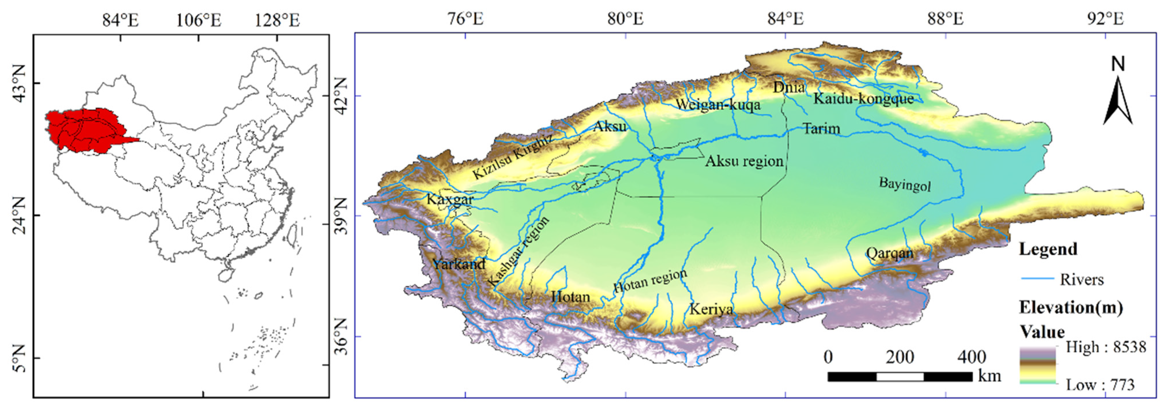
2.1. Study Area

The Tarim River Basin is located between the Tianshan and Kunlun Mountains, far from the sea (Figure 1). It forms a large portion of the mid-latitude Eurasian continental hinterland [26]. The basin consists of nine major water systems and about 144 rivers that surround it, with a total watershed area of 1.02 × 10⁶ km2 and a surface runoff of about 39.8 km3 [27]. At present, the only major rivers that are connected with surface water are the Aksu, Yarkand, Hotan, Kaidu-Kongque, and Tarim. The average annual precipitation in the region is about 51.2 mm, and the evaporation potential is as high as 2000–3000 mm, making it a resource water-scarce zone with fragile ecosystems and slow urbanization [28].

2.2. LUCC Data Sources and Classification

Land-use/cover data are obtained from the China Land Cover Dataset (CLCD). Data for 1990, 2000, 2010, and 2019 with a spatial resolution of 30 m × 30 m are selected. The CLCD data are based on 5463 visual interpretation samples with an overall accuracy of 79.31%. In addition to visual interpretation samples, the Geo-Wiki [29] and the Global Land Cover Validation Sample Set (GLCVSS) [30] are used to comprehensively verify the quality of CLCD. The validation results are CLCD (54.57%) > MCD12Q1 (51.97%) > ESACCI_LC (50.87%) > FROM-270 GLC (49.23%). In another GLCVSS validation result, CLCD has an accuracy of 65.64%, which is better than that of ESACCI_LC (57.16%), MCD12Q1 (61.66%), and GlobaLand30 (63.12%), respectively [31]. The CLCD dataset presented in this paper is available for free at the CLCD website (http://doi.org/10.5281/zenodo.4417810 accessed on 11 April 2022). The water and elevation information comes from the Resources and Environment Data Center of the Chinese Academy of Science (http://www.resdc.cn accessed on 11 April 2022).
The confusion matrix is the most popular method for evaluating the accuracy of remote sensing interpretation [32]. Therefore, this study randomly selected 150 samples from the Tarim River Basin oasis in 2019. The samples included cropland, grassland, woodland, built-up land, watershed, and barren land. The Kappa index is used to verify the accuracy of remote sensing data (Table 1). A higher Kappa index means a better model simulation.

2.3. Land-Use Transfer Matrix

The land-use transfer matrix reflects the dynamic process of the mutual transformation of the area of each land-use type during the study period. After calculating the area conversion of different land-use types in the Tarim River Basin, we analyzed the conversion process among different land-use types and explored the evolution process of land use further [22].
S i j = [ S 11 S 1 n S n 1 S n n ]
where S denotes area i, j (i, j = 1, 2, …, n) land-use types before and after transfer; Sij denotes the area of land-use change from type i to j; and n denotes the number of land-use types before and after transfer.

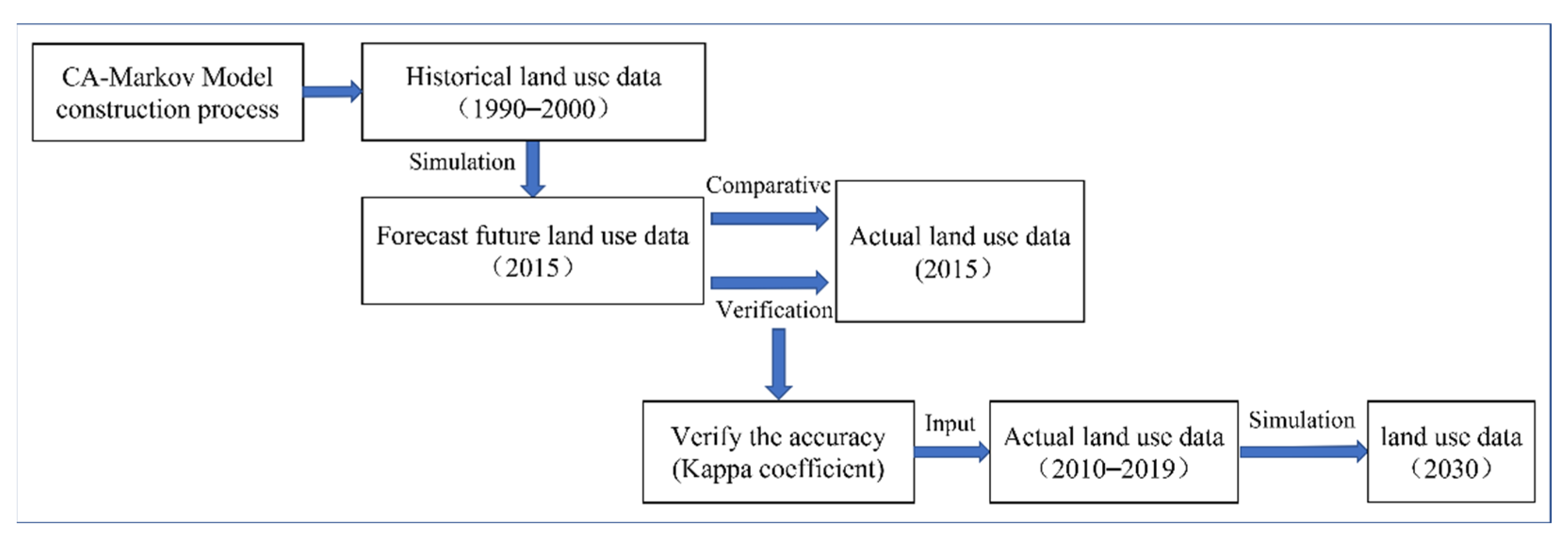
2.4. CA-Markov Model

The CA-Markov model is a method for predicting the probability of temporal occurrence based on the theory of Markov chain processes. The model is commonly used to predict geographical events without subsequent features [33]. The evolution of land use has the nature of the Markov process. At the same time, the land-use type corresponds to the “possible states” of the Markov process and the ratio of the mutual conversion of land-use types in the state transfer probability. We apply the CA-Markov model to simulate future land use in the Tarim River Basin [34] and express this relationship as:
S ( t + 1 ) = P i j × S t
  P i j = [ P 11 P 1 n P n 1 P n n ]
[ 0 P i j < 1 ,   and   j = 1 n P i j = 1 ( i . j = 1 , 2 n ) ]
where S(t+1) is the system state in period t + 1, and Pij is the state transfer probability matrix.
In this study, land-use data from 1990 and 2000 are used to predict the land use of the Tarim River Basin in 2015 through the CA-Markov module in Idrisi17.0 software. The results are compared with actual land-use data for 2015 to verify the reliability of the CA-Markov model simulation. Finally, the spatial data of land use in 2030 are predicted, with 2010 as the starting year (Figure 2). All images processed in Idrisi software are raster data. The size of the land raster used in this paper is 30 m × 30 m, and spatial data processing is completed in ArcGIS software.

2.5. Ecological Environmental Quality Index/Ecological Contribution Ratio

The Eco-environment Quality Index (EQI) is one of the indicators typically used to characterize the quality of the regional ecological environment quantitatively. The larger the value, the higher the quality of the ecological environment [35]. According to the change characteristics of different land types, the quantitative and spatial characteristics of regional ecological environment change were analyzed.
E V t = i = 1 n L U i × C i / T A
L E I = ( L E t + 1 L E t ) L A / T A
where LUi and Ci are the area of a certain land-use type and the relative ecological value of type i (Table 2), n is the number of land-use types, and LEt+1 and LEt denote the ecological quality index at the end and beginning of a certain land-use type change, respectively. LA is the area of that change type, and TA is the total area of the region [36,37].

3. Results

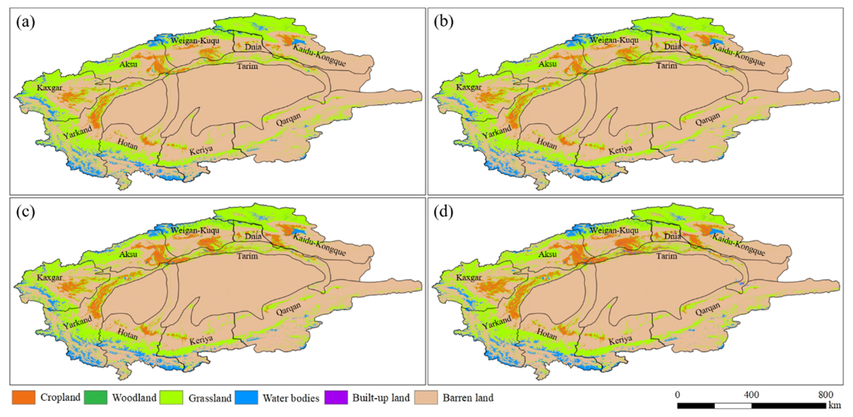
3.1. Evolution of Dynamic Land-Use Patterns

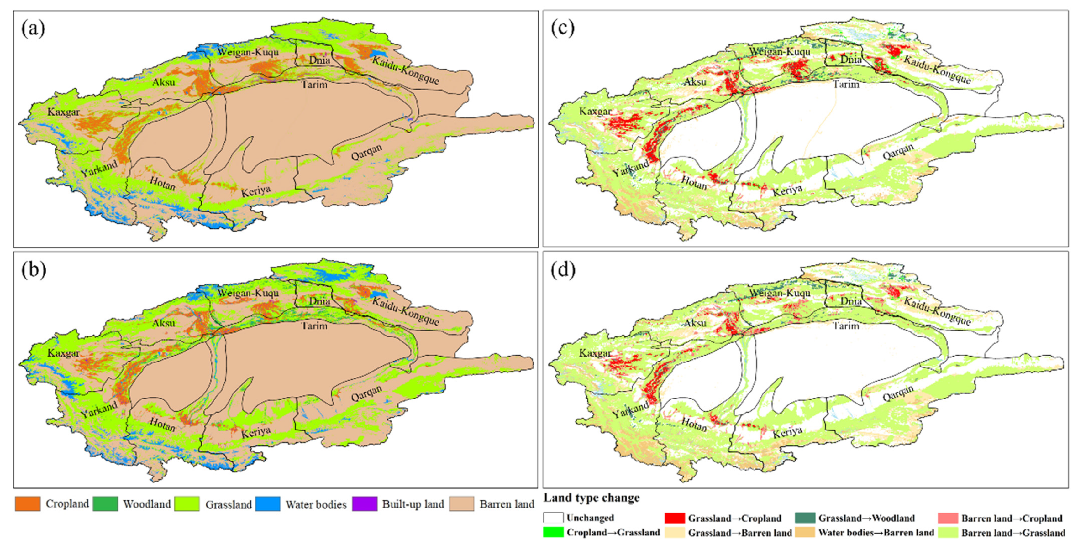
3.1.1. Land-Use/Cover Change

During 1990–2019, significant changes in land use occurred in the Tarim River Basin (Figure 3). There was an increase in cropland area of 18,850.51 km2, with a growth rate of 56.13%. The main areas of increase are as follows: the middle and upper reaches of the Tarim River Basin, the lower reaches of the Kashgar River, the lower reaches of the Aksu and Weigan–Kuqa rivers, and the middle and lower reaches of the Kaidu–Kongque River, with a small portion in the Hotan River. The barren land area decreased by 20,597.29 km2; the decrease was especially obvious in the middle reaches of the basin. Meanwhile, the woodland and construction land area increased by 1015.36 km2 and 2772.21 km2, respectively, mostly in the upper and middle reaches of the basin, and grassland and water body area decreased slightly (The changes in area of different land use types were shown in Table S1 in the Supplementary Material). Overall, the ranking of different land-use/cover types in the study region, except for woodland and construction land (two land types with a small area base), has remained relatively constant, showing barren land > grassland > cropland > water bodies (Figure 4).

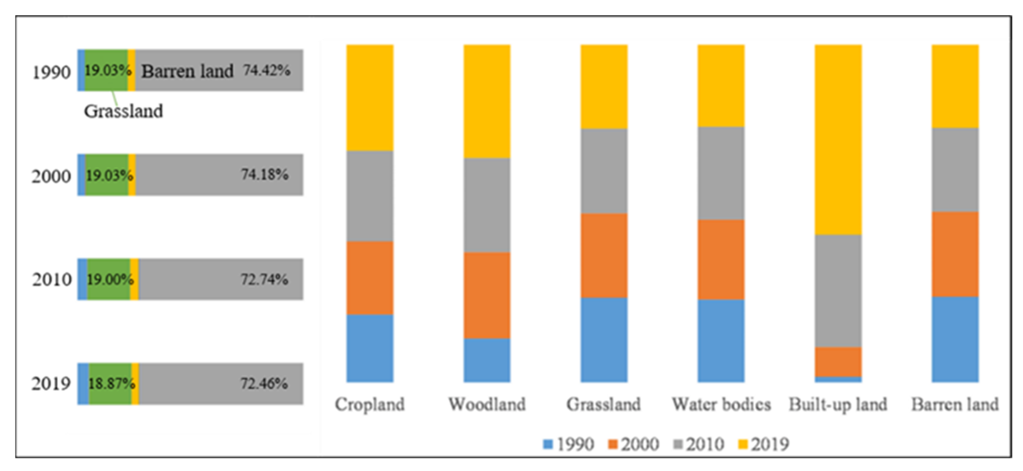
3.1.2. Analysis of Land-Use Structural Changes

As can be seen from the land-use type transfer matrix of the Tarim River Basin from 1990–2019 (Figure 5), there were frequent area transformations between land-use types. The period has been divided into four stages (1990–2000, 2000–2010, 2010–2019, and 1990–2019) for the analysis of land type interconversion.
(1) Interconversions between cropland, grassland, and barren land were very prominent from 1990 to 2000. The increase in cropland area was mainly due to conversions from grassland and barren land. In fact, the conversion of grassland to cropland accounted for 74.35% of the increase in cropland area during the period. This change was particularly evident in the middle and lower reaches of the Aksu and Kashgar rivers and the lower reaches of the Yarkand River. The conversion of barren land to cropland accounted for 36.67% of the increase in cropland, and mainly occurred near the middle and lower reaches of the Weigan–Kuqa and Kaidu–Kongque rivers. Increases in the area of woodland converted from cropland and grassland were also found in the upper reaches of the Weigan–Kuqa River and the middle reaches of the Kaidu–Kongque River, accounting for 16.55% and 70.22%, respectively. During the same 10-year period, 4.18% of water bodies were transformed into barren land, mostly in the upstream areas of the Yarkand and Hotan rivers, while 11.12% of grassland was interconverted to 3.18% of barren land.
(2) Cropland expanded considerably from 2000 to 2010. Most of this land was converted from grassland (77.28% of the area) in the downstream locations of the Weigan–Kuqa and Aksu rivers. The rest was converted from barren land (5.13%) concentrated near the downstream of the Kaidu–Kongque River. The conversion between grassland and other land types is also significant, with 7.14% of grassland converting to barren land, primarily in the Kaidu–Kongque and Qarqan rivers, and a small portion of grassland converting to woodland (0.09%) and water bodies (0.29%), mainly in the upper reaches of the Kaidu–Kongque and Weigan–Kuqa rivers. Barren land, on the other hand, was converted into grassland (2.87%) and water bodies (0.89%), mostly in the upstream location of the Tarim River Basin.
(3) The conversion between land types remained relatively stable from 2010 to 2019. As in the previous two periods (1990–2000 and 2000–2010), grassland and barren land continue to be converted to cropland, mainly in the lower reaches of the Kaidu–Kongque, Weigan–Kuqu, and the Yarkand rivers. Overall, the conversion area of grassland and barren land accounted for 74.13% and 24.44% of the increase in the area of cropland, respectively. There was also conversion of grassland to cropland in the upper reaches of the Weigan–Kuqu River, as well as the conversion of grassland to woodland (0.16%) and construction land (0.34%), while 0.69% of barren land was converted to grassland. The significant decrease in the area of water bodies is the result of their conversion to barren land and grassland, mainly in the upper reaches of the Aksu and Yarkand rivers, with a share of 11.89% and 0.26%, respectively.
(4) Throughout the entire study period (1990–2019), the area of grassland and barren land saw a major reduction, as these two land types transformed into other types. The main conversions that took place in the Tarim River Basin were of grassland to cropland, construction land, and woodland, along with the continuous development and utilization of barren land into cropland, grassland, and construction land. The encroachment of cropland on grassland and barren land, and the transformation of barren land into grassland and cropland, occurred simultaneously throughout the region, especially in the oasis area in the middle and upper reaches of the basin. The main reason for these transformations is the large-scale development of the oasis.

3.2. Impact of Land Use on Ecological Environment

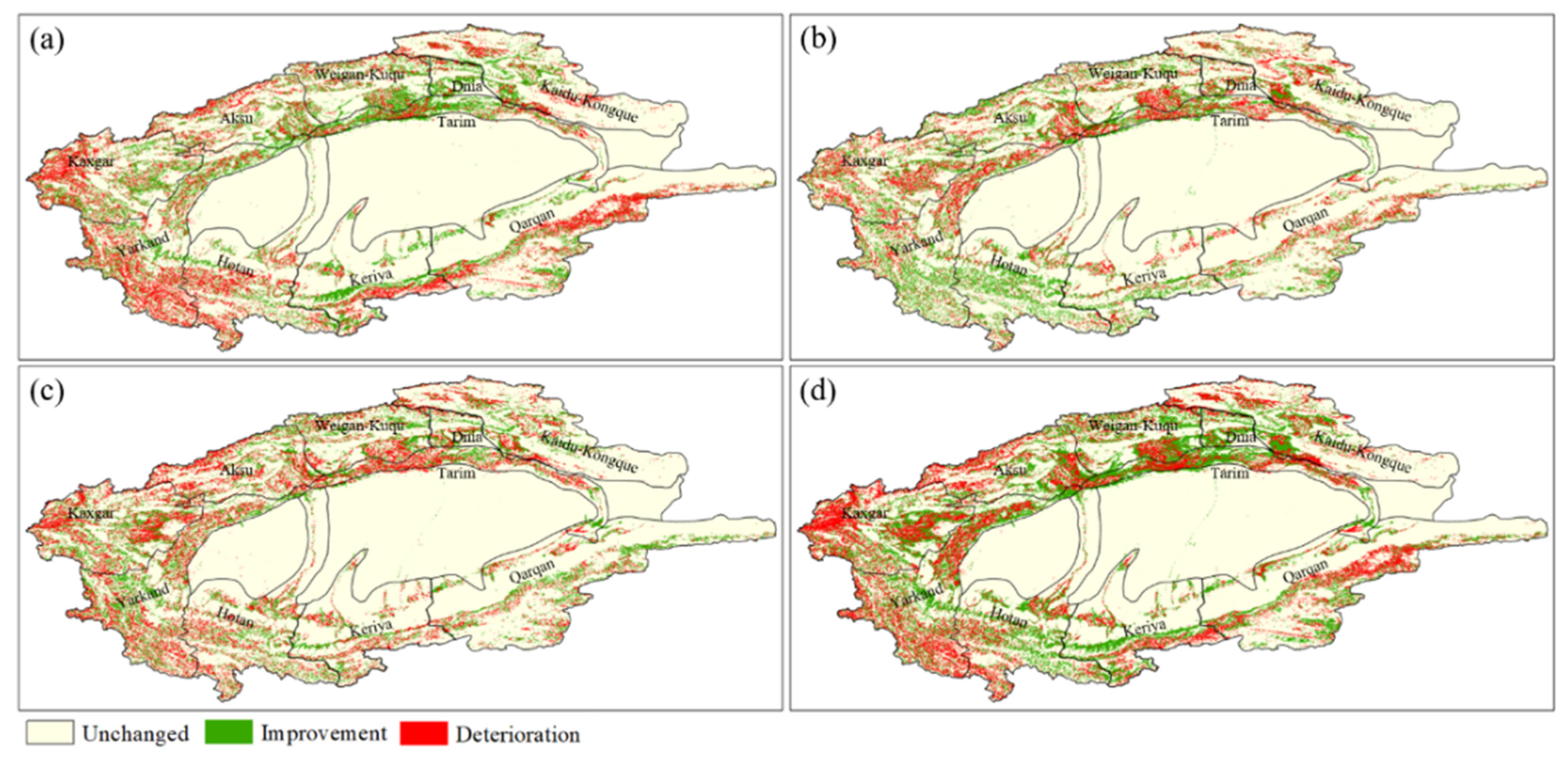
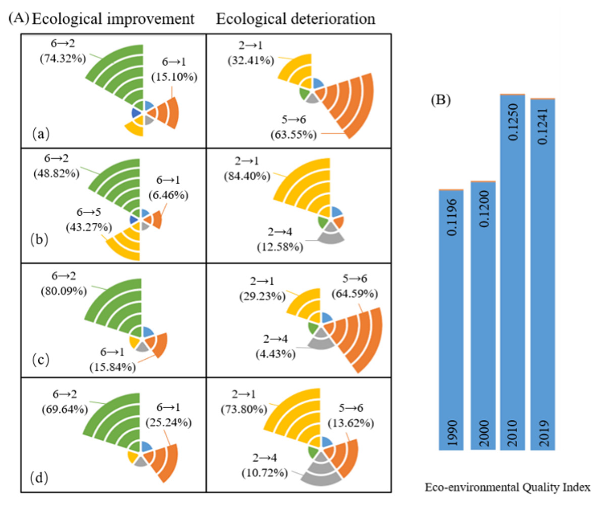
3.2.1. Spatial and Temporal Characteristics of the Ecological Environment

The overall EQI of the Tarim River Basin showed an increasing trend during 1990–2010. The EQI of the entire study area rose from 0.1196 to 0.1250, with most of the increase occurring in 2000–2010. However, the index showed a slight downward trend from 2010 to 2019. This is mainly due to the significant increase in cultivated land caused by population expansion, large-scale development of unused land, and surging demand for water. This further aggravated the competition for water between humans and the land, resulting in grassland degradation. The decrease in water bodies due to the demand on water resources and the degradation of grasslands caused by cropland expansion may have contributed to the decline in the ecological quality of the basin after 2010.
Although substantially more areas experienced improvement than deterioration in ecological quality from 1990 to 2010, the opposite was true from 2010 to 2019 (Figure 6). The interconversion between land types was particularly frequent throughout the study area from 2000 to 2010, resulting in significant changes in the ecological environment across the entire region. Even so, the overall ecological quality level of the Tarim River Basin tended to improve, with notable differences among different areas.
From 1990–2000, several areas of the basin improved in ecological quality, such as the Kaidu–Kongque, Weigan–Kuqu, and Kriya rivers and the middle reaches of the basin, while areas that deteriorated were located in the Yarkand and Hotan rivers. From 2000 to 2010, the ecological environment quality in the region as a whole was in a trend of continuous improvement, particularly the Hotan and Kriya rivers and the upper reaches of the Yarkand River. Areas of deterioration could be found in the lower reaches of the Yarkand, Aksu, and Weigan–Kuqu rivers. From 2010 to 2019, areas that previously saw improvements in ecological environment quality decreased significantly, while areas that saw deterioration increased their decline. This was mainly due to the relatively stable transformation between land types during this period, causing areas of deterioration to exceed areas of improvement. The trend posed a significant threat to the overall improvement of the ecological environment of the entire region.
Since 2010, the main reason for the deterioration of the ecological environment was that a large amount of grassland and water bodies transformed into cropland and barren land. Areas of prominent deterioration were mainly in the upper reaches of the Kashgar and Aksu rivers, and the lower reaches of the Weigan–Kuqa River. Areas of improvement were the middle reaches of the Qarqan, Kaidu–Kongque, and Yarkand rivers. In general, although the ecological and environmental quality of the study area was charting an upward trend during 1990–2019, it is currently in a downward trajectory. Therefore, it is still imperative to accelerate the process of improving the land-use structure by developing different land types in a balanced manner and optimizing various resources for sustainable development.

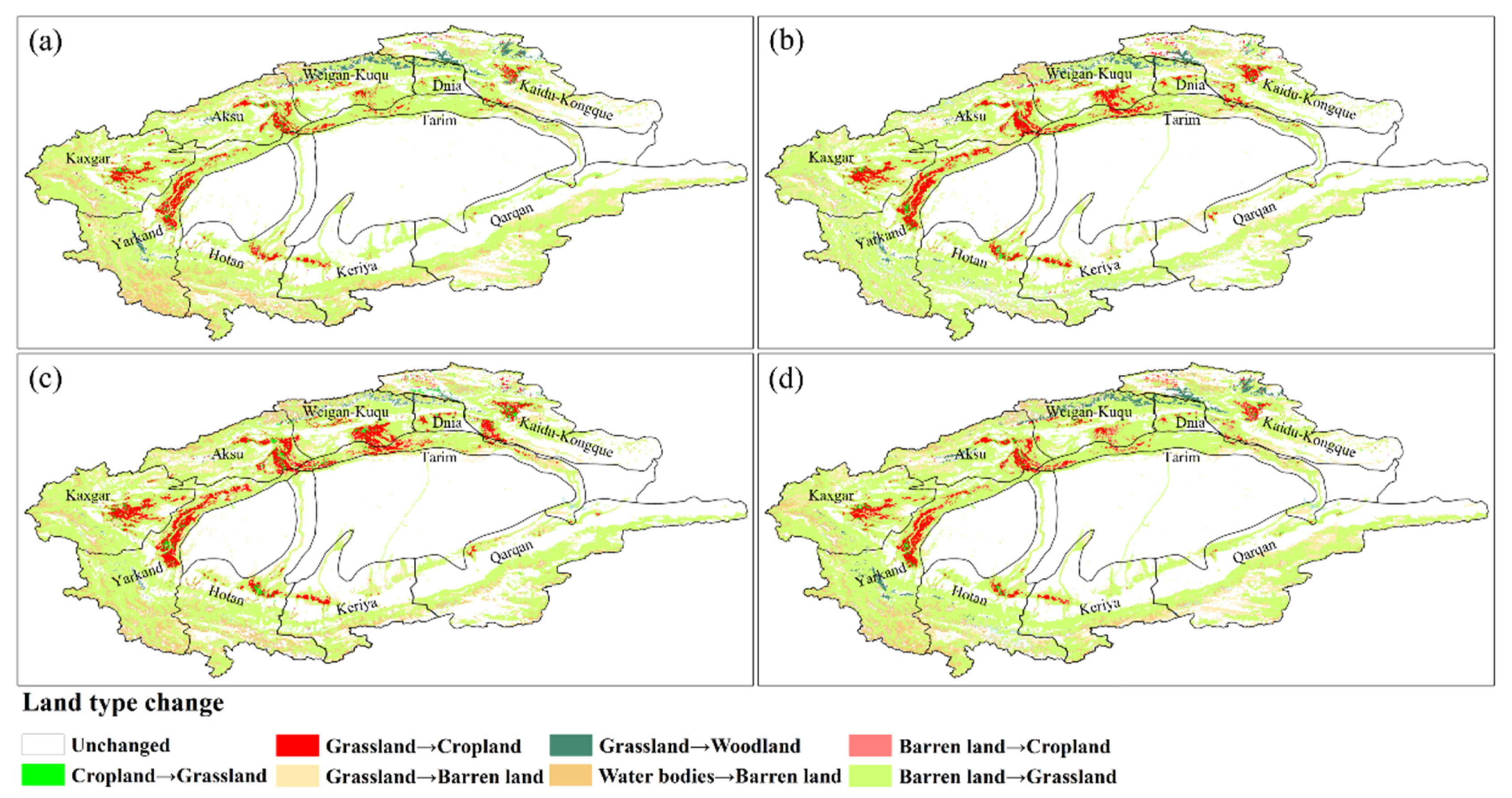
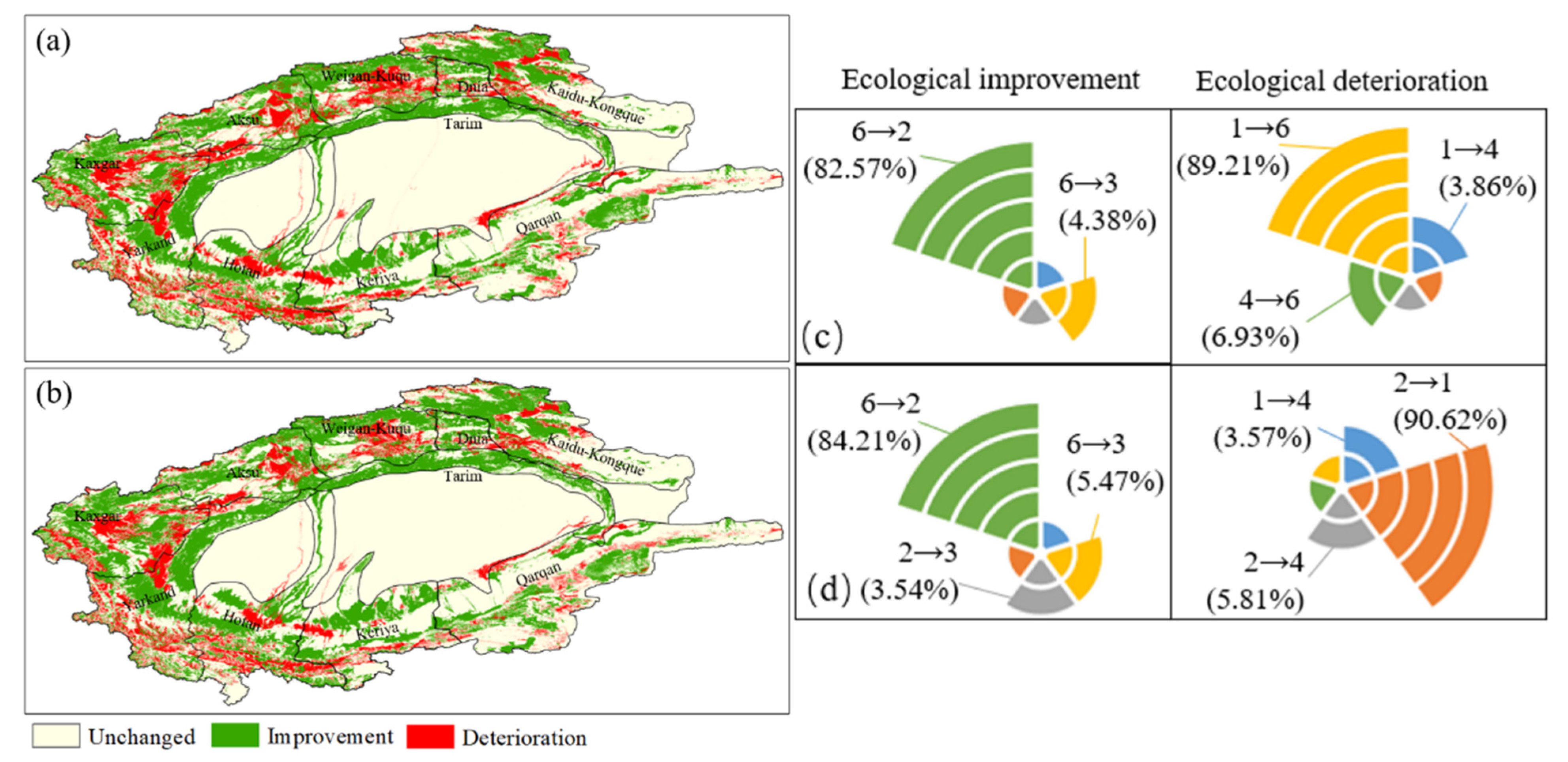
3.2.2. Impact of Different Land Use Conversions on the Ecological Environment

In analyzing the interconversion between different land types and the changes in the ecological environment in the region, we found that land-use changes during the period are closely related to ecological environment changes. The ecological contribution of land-use change was calculated to analyze the impact of interconversion between land types on the ecological environment during different time periods (Figure 7). To do so, we divided the study period into three stages. The first stage (1990–2000) showed six land type conversion processes that led to the improvement of the regional ecological environment quality. Of these six, the conversion of barren land to grassland saw the highest percentage of contribution (74.32%), while the conversion of barren land to cropland saw the next highest percentage (15.10%). The remaining conversion processes had only small contribution rates. These changes indicate that the conversion of barren land to grassland and cropland improved the quality of the ecological environment, while the conversion of grassland to cropland (32.41%) and construction land (4.04%), and of water bodies to barren land (63.55%), resulted in a quality deterioration.
Moreover, the conversion of barren land to grassland and water bodies is the main reason for improvements in the study area. The conversion of barren land to cropland was also advantageous, but accounted for only 6.46%. The primary cause of deterioration is the conversion of grassland to cropland, with a contribution of 84.40%, followed by the conversion of grassland to barren land (12.58%). Although there were many land type conversion processes that caused a deterioration in the ecological quality of the region in 2010–2019, only four processes led to its improvement. These four were dominated by the conversion of barren land to grassland and cropland, with the conversion to grassland accounting for 80.09%.
Furthermore, seven land type conversion processes led to the deterioration of the regional ecological environment. Our results show that the conversion of water bodies to barren land and the conversion of grassland to cropland mainly account for a higher proportion (64.59% and 29.23%, respectively), while the remaining conversion processes account for a relatively small proportion. These data clearly show the impact of the rising population and increasing demand for land during this period, coupled with the over-exploitation of water resources. The remaining conversion process accounts for a relatively small proportion of the total, indicating that the rising population and increasing land demand, along with the over-exploitation and unreasonable distribution of water resources, have led to the expansion of cropland, the degradation of grassland, and the scarcity of water resources in the region. The outcome of these events has been the deterioration of the ecological environment, unbalanced land-use structure, and extreme instability in the oasis.
In general, however, the EQI of the Tarim River Basin has shown an increasing trend since 1990. Among the interconversion of various land types, the conversion of barren land to grassland and cropland played a key role in improving the regional ecological environment, especially the conversion to grassland (contribution of 69.64%). The main factors leading to the deterioration were the conversion of grassland to cropland and construction land, along with the conversion of water bodies to barren land. Specifically, the conversion of grassland to cropland accounted for 73.80%, while the remaining two processes only accounted for 10.72% and 13.62%, respectively. Overall, the continuous development of barren land into grassland has had a positive effect on the ecological environment in the region. Nevertheless, the rapid development of society and subsequent excessive expansion of cropland (including from grassland), coupled with the increasing shortage of soil and water resources and the deterioration of the ecological environment, may seriously affect the sustainable development of the local ecology.

3.3. Future Changes in Watershed Ecosystem Patterns

Land-use structure is strongly linked to regional ecosystems, which means that changes in this structure can have a significant impact on the regional ecology. We analyze changes in land-use structure in the Tarim River Basin by selecting land-use data from 2010 and 2019 to apply to simulation projections for 2019 to 2030. Based on the impact of land-use type conversion on the ecological environment, we discuss the relationship between future land development and ecological environment in the watershed (Supplementary Material Figure S1 and Table S2 showed simulated and actual land use changes and error results in 2015).
We found that the transformation between various land types in the Tarim River Basin is quite frequent during different periods, and that the main feature is the mutual transformation of cropland, grassland, barren land, and other land types (Figure 8). From 2019 to 2030, we anticipate that most of the cropland will transform into woodland, grassland, and barren land, and that most of these changes will occur in the Kaidu–Kongque, Weigan–Kuch, and Kashgar rivers, as well as in the lower reaches of the Yarkand River. Furthermore, a significant reduction in grassland area may occur mainly in the lower reaches of the Kaidu–Kongque River and the middle and lower reaches of the Qarqan River, with a conversion rate of 20.43% to barren land and a small portion of grassland to woodland and water bodies. The conversion of barren land to grassland, woodland, and water bodies will likely be significant in the Weigan–Kuqu, Kashgar, Yarkand, Hotan, and Kriya rivers.
At the same time, we anticipate that cropland, grassland, and barren land will become the three most active land types from 2019 to 2030. The transformation of cropland in the oasis will be very obvious, but the transformation magnitude will decrease significantly. Additionally, the transformation of cropland and barren land to grassland will mainly be concentrated in the middle reaches of the Tarim River Basin, while the areas transforming into barren land will primarily include the Kaidu–Kongque, Aksu, and Qarqan rivers. The transformation of all three land types to woodland, water bodies, and construction land may occur as well, leading to an increase in the area of the other three land types, with the conversion process to other land types expected to be extremely intense.
The future EQI of the Tarim River Basin shows a continuous upward trend at a relatively fast rate of 7.17%, indicating that the areas where improvement occurs in the basin are significantly much larger than areas where deterioration occurs (Figure 9). In comparing past ecological environment changes (1990–2019) with future changes, we find that during 2019–2030, more areas of improvement will occur near the middle and upper reaches of the Kaidu–Kongque River, the upper reaches of the Kashgar River, the lower reaches of the Yarkand River, and the Qarqan River basin in general. Areas where deterioration will occur are mainly located in the middle and lower reaches of the Weigan–Kuqa River, the middle reaches of the Aksu River, and the middle and upper reaches of the Hotan River. However, we anticipate that there will be more areas with improved ecological environment quality than areas with deteriorating quality.
Based on our projections, the basin’s ecological environment is clearly developing in a positive direction. Specifically, the areas of improvement are much larger than the areas of deterioration, probably due to factors, such as slow development and use of cropland and barren land. On the other hand, since the main characteristics of the ecological environmental changes are similar to those of the previous stage, they can also indicate that after 2019, all land types in the basin will develop in a balanced way and the ecological environment will enter a steady improvement stage [38].
In comparing and screening numerous land-use transfer processes, we found that five conversion processes had a positive effect on the improvement of the ecological environment. The conversion of barren land to grassland is the dominant factor in improving the regional ecological environment, followed by the conversion of unused land to woodland. The ecological degradation processes in the watershed caused by land transfer during the period all included the conversion of cropland to construction land, but the dominant factors were different, with the conversion of cropland to barren land (89.21%) and the conversion of grassland to cropland (90.62%) being the main factors causing regional ecological degradation in the two stages, respectively. Thus, the large amount of barren land developed into grassland and woodland throughout the period is the main reason for improvements in the ecological environment and for the occurrence of ecological decline and deterioration. Hence, we need to fundamentally reduce the abandonment of a large amount of farmland and maintain the sustainable use of soil and water resources [25]. As well, we need to protect the function and structure of grassland resources and ecosystems, and maintain the synergistic development of the regional economy and ecological environmental development.

4. Discussion

4.1. Policy Reasons for Land Use Change

We selected CLCD remote sensing data products to explore land-use changes in the Tarim River Basin from 1990 to 2019, analyzing the evolution of spatial-temporal patterns of land use and changes in land structure in the basin. During 1990–2019, land-use/cover changes in the Tarim River Basin were mainly characterized by a significant expansion of cropland and a reduction in the area of barren land. The encroachment of cropland on grassland and barren land and the conversion of barren land to grassland and cropland occurred simultaneously throughout the region, especially in the oasis areas in the middle and upper reaches of the basin. New cropland mainly came from grassland and barren land, whereas the growth rate of construction land area was more stable and had a tendency to increase. This latter characteristic was due to the continuous rise of local economic development and accelerated urbanization [22]. Among these changes, the growth in cropland was primarily the result of a substantial growth in population and economic development, which led to a surge in the demand for land to meet development needs [7].
In addition, under the dual role of policy support and interest-driven development, the cropland area in the basin has shown continuous expansion marked by three accelerated development characteristics. The first of these is the implementation, since 1995, of economic policies under the “one black, one white” strategy of large enterprises and groups. The policies are promoted by the people’s government of the Xinjiang Uygur Autonomous Region, with the aim of restructuring regional industry [39]. The second characteristic, implemented since 2001, is the increased investment of national and autonomous regions in poverty alleviation and the tilting of central policies on poverty alleviation in Xinjiang. The third characteristic, introduced in 2010, is the implementation of comprehensive national aid work, which has proven crucial for the continuous expansion of regional cropland area [28].
Analyzing land-use change from the perspective of policy factors, we found that preferential policies stimulate agricultural development, and that agricultural development is inseparable from the implementation of policies. Current policies support accelerating the expansion of cultivated land and developing the oasis, which means that the amount of irrigated area will also rise, along with the excessive consumption of water resources. As the modern management level of water resources is still low, it is critically important to strengthen the ability of relevant departments to monitor and control water resources.

4.2. Ecological Status Change Problems

To explore changes in the quality of the ecological environment in the Tarim River Basin, we selected transfer matrix and ecological contribution rate, combined with the CA-Markov model, to analyze current and future land-use change. We also analyzed the ecological effect of land-use change from the perspective of different land type transformations. In looking at the historical development process of the basin, we can see that the problems related to “treating while opening up land, and wasting while saving water” have become widespread practices due to a lack of environmental protection, as well as a lack of awareness of the need for such protection [27]. The current level of development and allocation of soil and water resources is highly detrimental to the ecological security and sustainable development of soil and water resources in the basin [40]. In recent years, in order to meet the needs of population growth and economic development, the oasis has constantly expanded. The resulting ecological problems have arisen mainly through large-scale development of cropland, reclamation of barren land, vigorous promotion of urbanization, and large-scale planting of crops [41].
At the same time, decades of over-exploitation and misuse of natural resources have led to increasingly prominent conflicts between ecological and agricultural water usage. The result has been a decline in the water table in the desert-oasis transition zone, a reduction in natural vegetation, and widespread damage to ecosystem structures, among other ecological and environmental problems [42]. The intensification of the global warming process has led to an acceleration of snow and ice melt in the mountains, increasing the runoff in these locations [43]. However, due to the expansion of regional cropland, the irrigated area of the oasis has expanded, along with agricultural water consumption. Hence, because agriculture has significantly increased, actual water intake has not.
According to the results, the main reasons for the improvement of the ecological environment in the current and future periods are the conversion of unused land to grassland and cropland, and the conversion of unused land to grassland and woodland, respectively. However, whether at present or in the future, excessive expansion of cropland and encroachment on grassland will lead to deterioration of the ecological environment. Therefore, the ecological degradation of the Tarim River Basin leaves the region to face the very great challenge of restoration [44]. With the ongoing development of urbanization and industrialization, the land structure of the basin will become the main problem affecting the ecological environment and thus hindering regional stability and development. The scarcity of water resources will further limit the basin’s socio-economic progress. In arid locations where water resources are scarce, balancing the area of cultivated land, grassland, and woodland is more conducive to the improvement of the ecological environment and sustainable development.

4.3. Watershed Ecological Risks and Management Suggestions

Since 1990, rapid economic development in the Tarim River Basin has resulted in a large amount of land being reclaimed for development. At the same time, the increase in agricultural crops that depend on irrigation for growth has led to the over-exploitation of groundwater, causing water scarcity, increased soil salinization [45], reduced soil fertility, and diminished cropland quality. These outcomes have inhibited crop metabolism and adaptation, resulting in reduced crop yields and massive vegetation mortality [46]. In addition to agricultural problems, the over-exploitation of land and water resources has contributed to the disappearance of many native species. With the simplification of species structure, biodiversity will decrease and grassland degradation will intensify. The current trend of desertification poses a serious threat to the stability of watersheds and the ecology of oases [41].
Despite these negative effects, there have also been improvements to the ecological environment brought by the impact of land-use changes. In particular, the recent obvious expansion of woodland and grassland area has had a positive effect on the regional ecological environment. Moreover, with the continuous promotion of urbanization, the increase in construction land is more conducive to adjusting and improving the local land-use structure [47]. Other improvements include the implementation of the ecological water transfer policy, which has effectively restored the ecology of the basin. The ecological water transfer project of the lower Tarim River Basin for the purpose of “ecological restoration” has shown a positive impact on the ecological protection and reconstruction of the region [48].
In conclusion, although the current phase of cropland expansion also implies rapid economic development, the sensitivity of ecological environment is still an important issue that cannot be ignored [49]. Since agriculture and animal husbandry remain the dominant industries in the region, changes in land-use structure mostly concern cropland and grassland area. Accordingly, the relevant departments need to improve the degree of land use through more effective measures, such as rationalizing the use of land resources, slowing down the expansion of cropland, controlling soil salinization, and speeding up the modernization of agriculture.

5. Conclusions

This paper investigated changes in current and future land-use patterns in the Tarim River Basin, with the transition matrix and ecological contribution rate being selected to analyze the ecological impacts of the transformations between different land-use types. The following are the key findings:
During the study period (1990–2019), grassland and barren land were the main land types in the Tarim River Basin, accounting for 72.46% and 18.87% of the basin’s area, respectively. The most prominent features of land-use/cover change in the basin were the continuous expansion of cropland and decrease in barren land, with cropland increasing by 18,850.51 km2 and barren land decreasing by 20,597.29 km2. The most significant decrease occurred during 2000–2010.
Furthermore, there were frequent conversions of land types. These conversions were dominated by grassland converting to cropland, followed by construction land converting to woodland. Barren land converted to cropland, grassland, and construction land. The simulation of the land-use patterns for 2019 to 2030 showed an increase in grassland, woodland, and water bodies. The decrease in barren land and cropland were mainly concentrated in the Kaidu–Kongque, Aksu, and Kashgar river basins. The land transformation process during the proposed period is mostly based on the interconversion of cropland, grassland, barren land, and other land types.
Despite ongoing issues, the ecological environment in the Tarim River Basin is on an upward trend, with a particularly significant increase occurring between 1990 and 2010. The main reason for this improvement is the conversion of barren land to grassland and cropland, respectively. The conversion of barren land to grassland contributed 69.64%. However, the conversion of grassland to cropland (73.80%) and construction land, and water bodies to barren land, were the main factors contributing to the deterioration. In fact, the over-expansion of cropland and its encroachment on grassland has led to a massive decline in the ecological environment and hindered the sustainable development of the ecology. Nevertheless, based on the prediction results of the CA-Markov model, the ecological environment in the watershed is expected to steadily improve from 2019 to 2030. This is due to barren land changing into grassland and woodland. We also found that barren land changing into grassland has had a positive effect on the region’s ecology.

Supplementary Materials

The following supporting information can be downloaded at https://www.mdpi.com/article/10.3390/rs14081894/s1. Figure S1: Map of simulated and actual land-use change in the Tarim River Basin in 2015; Table S1: Area changes by land type in the Tarim River Basin; Table S2: Land type areas and errors of simulated and actual land classes in the Tarim River Basin in 2015.

Author Contributions

Y.H. and Y.C. conceived the original design of this paper, J.D. and Z.L. improved its structure, and Y.L. and F.S. provided comments. All authors have read and agreed to the published version of the manuscript.

Funding

The research was supported by the International Cooperation program of Chinese Academy of Sciences (131965KYSB20210045) and the Cross Team Project of the “Light of West China” Program of CAS (E0284101).

Institutional Review Board Statement

Not applicable.

Informed Consent Statement

Not applicable.

Data Availability Statement

The data presented in this study are available on request from the corresponding author.

Acknowledgments

We thank the School of Remote Sensing and Information Engineering and the State Key Laboratory of Information Engineering in Surveying, Mapping and Remote Sensing, Wuhan University for providing the China Land Cover Dataset (CLCD).

Conflicts of Interest

The authors declare no conflict of interest.

References

  1. Jiang, L.; Liu, Y.; Wu, S.; Yang, C. Analyzing ecological environment change and associated driving factors in China based on NDVI time series data. Ecol. Indic. 2021, 129, 9. [Google Scholar] [CrossRef]
  2. Borgwardt, F.; Robinson, L.; Trauner, D.; Teixeira, H.; Nogueira, A.J.; Lillebo, A.I.; Piet, G.; Kuemmerlen, M.; O’Higgins, T.; McDonald, H.; et al. Exploring variability in environmental impact risk from human activities across aquatic ecosystems. Sci. Total Environ. 2019, 652, 1396–1408. [Google Scholar] [CrossRef]
  3. Wang, C.; Jiang, Q.; Shao, Y.; Sun, S.; Xiao, L.; Guo, J. Ecological environment assessment based on land use simulation: A case study in the Heihe River Basin. Sci. Total Environ. 2019, 697, 14. [Google Scholar] [CrossRef] [PubMed]
  4. Beauchard, O.; Verissimo, H.; Queiros, A.M.; Herman, P.M. The use of multiple biological traits in marine community ecology and its potential in ecological indicator development. Ecol. Indic. 2017, 76, 81–96. [Google Scholar] [CrossRef]
  5. Yang, Z.; Li, W.; Li, X.; Wang, Q.; He, J. Assessment of eco-geo-environment quality using multivariate data: A case study in a coal mining area of Western China. Ecol. Indic. 2019, 107, 13. [Google Scholar] [CrossRef]
  6. Mainuri, Z.G.; Owino, J.O. Linking landforms and land use to land degradation in the Middle River Njoro Watershed. Int. Soil Water Conserv. Res. 2014, 2, 1–10. [Google Scholar] [CrossRef] [Green Version]
  7. Zhang, Y.; Wu, D.; Lyu, X. A review on the impact of land use/land cover change on ecosystem services from a spatial scale perspective. J. Nat. Resour. 2020, 35, 1172–1189. [Google Scholar]
  8. Ayanlade, A.; Howard, M.T. Understanding changes in a Tropical Delta: A multi-method narrative of landuse/landcover change in the Niger Delta. Ecol. Model. 2017, 364, 53–65. [Google Scholar] [CrossRef]
  9. Li, D.; Tian, P.; Luo, H.; Hu, T.; Dong, B.; Cui, Y.; Khan, S.; Luo, Y. Impacts of land use and land cover changes on regional climate in the Lhasa River basin, Tibetan Plateau. Sci. Total Environ. 2020, 742, 13. [Google Scholar] [CrossRef]
  10. Lasanta, T.; Arnaez, J.; Pascual, N.; Ruiz-Flano, P.; Errea, M.P.; Lana-Renault, N. Space-time process and drivers of land abandonment in Europe. Catena 2017, 149, 810–823. [Google Scholar] [CrossRef]
  11. Liu, X.; Liang, X.; Li, X.; Xu, X.; Ou, J.; Chen, Y.; Li, S.; Wang, S.; Pei, F. A future land use simulation model (FLUS) for simulating multiple land use scenarios by coupling human and natural effects. Landsc. Urban Plan. 2017, 168, 94–116. [Google Scholar] [CrossRef]
  12. Hu, C.; Zhang, L.; Wu, Q.; Soomro, S.E.; Jian, S. Response of LUCC on Runoff Generation Process in Middle Yellow River Basin: The Gushanchuan Basin. Water 2020, 12, 14. [Google Scholar] [CrossRef]
  13. Spera, S.A.; Galford, G.L.; Coe, M.T.; Macedo, M.N.; Mustard, J.F. Land-use change affects water recycling in Brazil’s last agricultural frontier. Glob. Chang. Biol. 2016, 22, 3405–3413. [Google Scholar] [CrossRef] [PubMed]
  14. Yang, Y. Evolution of habitat quality and association with land-use changes in mountainous areas: A case study of the Taihang Mountains in Hebei Province, China. Ecol. Indic. 2021, 129, 12. [Google Scholar] [CrossRef]
  15. Yu, Y.; Li, J.; Zhou, Z.; Ma, X.; Zhang, X. Response of multiple mountain ecosystem services on environmental gradients: How to respond, and where should be priority conservation? Clean Prod. 2021, 278, 15. [Google Scholar] [CrossRef]
  16. Borrelli, P.; Robinson, D.A.; Fleischer, L.R.; Lugato, E.; Ballabio, C.; Alewell, C.; Meusburger, K.; Modugno, S.; Schütt, B.; Ferro, V. An assessment of the global impact of 21st century land use change on soil erosion. Nat. Commun. 2017, 8, 2013. [Google Scholar] [CrossRef] [Green Version]
  17. Hu, M.; Li, Z.; Wang, Y.F.; Jiao, M.; Li, M.; Xia, B. Spatio-temporal changes in ecosystem service value in response to land-use/cover changes in the Pearl River Delta. Resour. Conserv. Recycl. 2019, 149, 106–114. [Google Scholar] [CrossRef]
  18. Tian, S.; Wang, S.; Bai, X.; Zhou, D.; Luo, G.; Yang, Y.; Hu, Z.; Li, C.; Deng, Y.; Lu, Q. Ecological security and health risk assessment of soil heavy metals on a village-level scale, based on different land use types. Environ. Geochem. Health 2020, 42, 3393–3413. [Google Scholar] [CrossRef]
  19. Jin, G.; Deng, X.; Chu, X.; Li, Z.; Wang, Y. Optimization of land-use management for ecosystem service improvement: A review. Phys. Chem. Earth 2017, 101, 70–77. [Google Scholar] [CrossRef]
  20. Ji, Y.; Bai, Z.; Hui, J. Landscape Ecological Risk Assessment Based on LUCC-A Case Study of Chaoyang County, China. Forests 2021, 12, 16. [Google Scholar] [CrossRef]
  21. Du, X.; Huang, Z. Ecological and environmental effects of land use change in rapid urbanization: The case of hangzhou, China. Ecol. Indic. 2017, 81, 243–251. [Google Scholar] [CrossRef]
  22. Long, H.; Liu, Y.; Hou, X.; Li, T.; Li, Y. Effects of land use transitions due to rapid urbanization on ecosystem services: Implications for urban planning in the new developing area of China. Habitat Int. 2014, 44, 536–544. [Google Scholar] [CrossRef]
  23. Chen, Y.; Hao, X.; Chen, Y.; Zhu, C. Study on Water System Connectivity and Ecological Protection Countermeasures of Tarim River Basin in Xinjiang. Bull. Chin. Acad. Sci. 2019, 34, 1156–1164. [Google Scholar]
  24. Muyibul, Z.; Xia, J.; Muhtar, P.; Shi, Q.; Zhang, R. Spatiotemporal changes of land use/cover from 1995 to 2015 in an oasis in the middle reaches of the Keriya River, southern Tarim Basin, Northwest China. Catena 2018, 171, 416–425. [Google Scholar] [CrossRef]
  25. Wang, W.; Chen, Y.; Wang, W. Groundwater recharge in the oasis-desert areas of northern Tarim Basin, Northwest China. Hydrol. Res. 2020, 51, 1506–1520. [Google Scholar] [CrossRef]
  26. Fang, G.; Yang, J.; Chen, Y.; Li, Z.; Ji, H.; De Maeyer, P. How Hydrologic Processes Differ Spatially in a Large Basin: Multisite and Multiobjective Modeling in the Tarim River Basin. J. Geophys. Res. Atmos. 2018, 123, 7098–7113. [Google Scholar] [CrossRef]
  27. Chen, Y.; Xu, C.; Hao, X.; Li, W.; Chen, Y.; Zhu, C.; Ye, Z. Fifty-year climate change and its effect on annual runoff in the Tarim River Basin, China. Quat. Int. 2009, 208, 53–61. [Google Scholar]
  28. Chen, Y.; Ye, Z.; Shen, Y. Desiccation of the Tarim River, Xinjiang, China, and mitigation strategy. Quat. Int. 2011, 244, 264–271. [Google Scholar] [CrossRef]
  29. Fritz, S.; See, L.; Perger, C.; McCallum, I.; Schill, C.; Schepaschenko, D.; Duerauer, M.; Karner, M.; Dresel, C.; Laso-Bayas, J.C.; et al. A global dataset of crowdsourced land cover and land use reference data. Sci. Data 2017, 4, 170075. [Google Scholar] [CrossRef] [Green Version]
  30. Zhao, Y.; Gong, P.; Yu, L.; Hu, L.; Li, X.; Li, C.; Zhang, H.; Zheng, Y.; Wang, J.; Zhao, Y.; et al. Towards a common validation sample set for global land-cover mapping. Int. J. Remote Sens. 2014, 35, 4795–4814. [Google Scholar] [CrossRef]
  31. Yang, J.; Huang, X. The 30 m annual land cover dataset and its dynamics in China from 1990 to 2019. Earth Syst. Sci. Data 2021, 13, 3907–3925. [Google Scholar]
  32. Pontius, R.G.; Millones, M. Death to Kappa: Birth of quantity disagreement and allocation disagreement for accuracy assessment. Int. J. Remote Sens. 2011, 32, 4407–4429. [Google Scholar]
  33. Veldkamp, A.; Lambin, E. Predicting land-use change. Agric. Ecosyst. Environ. 2001, 85, 1–6. [Google Scholar] [CrossRef]
  34. Bcp, A.; Dgb, B.; Bas, C.; Gam, D. Using neural networks and GIS to forecast land use changes: A Land Transformation Model. Computers. Environ. Urban Syst. 2002, 26, 553–575. [Google Scholar]
  35. Chen, D.; Lu, X.; Hu, W.; Zhang, C.; Lin, Y. How urban sprawl influences eco-environmental quality: Empirical research in China by using the Spatial Durbin model. Ecol. Indic. 2021, 131, 108113. [Google Scholar] [CrossRef]
  36. Liu, Y.; Gao, J.; Yang, Y. A holistic approach towards assessment of severity of land degradation along the Great Wall in Northern Shaanxi Province, China. Environ. Monit. Assess. 2003, 82, 187–202. [Google Scholar] [CrossRef]
  37. Sudhira, H.S.; Ramachandra, T.V.; Jagadish, K.S. Urban sprawl: Metrics, dynamics and modelling using GIS. Int. J. Appl. Earth Obs. Geoinf. 2004, 5, 29–39. [Google Scholar] [CrossRef]
  38. Wang, X.; Li, Y.; Wang, X.; Gong, X. Temporal and Spatial Variations in NDVI and Analysis of the Driving Factors in the Desertified Areas of Northern China from 1998 to 2015. Front. Environ. Sci. 2021, 9, 633020. [Google Scholar] [CrossRef]
  39. Wang, Y.; Chen, Y.; Ding, J.; Fang, G. Land-use conversion and its attribution in the Kaidu-Kongqi River Basin, China. Quat. Int. 2015, 380, 216–223. [Google Scholar] [CrossRef]
  40. Chen, Y.; Takeuchi, K.; Xu, C.; Chen, Y.; Xu, Z. Regional climate change and its effects on river runoff in the Tarim Basin, China. Hydrol. Processes 2010, 20, 2207–2216. [Google Scholar] [CrossRef]
  41. Chen, Y.; Li, B.; Fan, Y.; Sun, C.; Fang, G. Hydrological and water cycle processes of inland river basins in the arid region of Northwest China. J. Arid Land. 2019, 11, 161–179. [Google Scholar] [CrossRef] [Green Version]
  42. Sun, F.; Wang, Y.; Chen, Y.; Li, Y.; Zhang, Q.; Qin, J.; Kayumba, P.M. Historic and Simulated Desert-Oasis Ecotone Changes in the Arid Tarim River Basin, China. Remote Sens. 2021, 13, 16. [Google Scholar] [CrossRef]
  43. Li, B.; Chen, Y.; Li, W.; Chen, Z.; Zhang, B.; Guo, B. Spatial and Temporal Variations of Temperature and Precipitation in the Arid Region of Northwest China from 1960–2010. Fresenius Environ. Bull. 2013, 22, 362–371. [Google Scholar]
  44. Li, Z.; Chen, Y.; Wang, Y.; Li, W. Drought promoted the disappearance of civilizations along the ancient Silk Road. Environ. Earth Sci. 2016, 75, 7. [Google Scholar] [CrossRef]
  45. Xue, L.; Wang, J.; Zhang, L.; Wei, G.; Zhu, B. Spatiotemporal analysis of ecological vulnerability and management in the Tarim River Basin, China. Sci. Total Environ. 2019, 649, 876–888. [Google Scholar] [CrossRef] [PubMed]
  46. Wang, Q.; Li, W.; Li, T.; Li, X.; Liu, S. Goaf water storage and utilization in arid regions of northwest China: A case study of Shennan coal mine district. J. Clean Prod. 2018, 202, 33–44. [Google Scholar] [CrossRef]
  47. Li, Z.; Xu, Y.; Sun, Y.; Wu, M.; Zhao, B. Urbanization-Driven Changes in Land-Climate Dynamics: A Case Study of Haihe River Basin, China. Remote Sens. 2020, 12, 2701. [Google Scholar] [CrossRef]
  48. Hao, X.; Hao, H.; Zhang, J. Soil moisture influenced the variability of air temperature and oasis effect in a large inland basin of an arid region. Hydrol. Processes 2021, 35, e14246. [Google Scholar] [CrossRef]
  49. Gomes, E.; Inacio, M.; Bogdzevi, K.; Kalinauskas, M.; Karnauskait, D.; Pereira, P. Future land-use changes and its impacts on terrestrial ecosystem services: A review. Sci. Total Environ. 2021, 781, 11. [Google Scholar] [CrossRef]
Figure 1. Sketch map of the Tarim River Basin, China. The map is from the Chinese Standard Map (http://bzdt.ch.mnr.gov.cn/GS (accessed on 11 April 2022) (2019)1822).
Remotesensing 14 01894 g001
Figure 2. Land use simulation process.
Remotesensing 14 01894 g002
Figure 3. Land uses in the Tarim River Basin from 1990 to 2019: (a) 1990; (b) 2000; (c) 2010; and (d) 2019.
Remotesensing 14 01894 g003
Figure 4. Land-use type changes in the Tarim River Basin.
Remotesensing 14 01894 g004
Figure 5. Land-use transfer map of the Tarim River Basin from 1990 to 2019: (a) 1990–2000; (b) 2000–201; (c) 2010–2019; and (d) 1990–2019.
Remotesensing 14 01894 g005
Figure 6. Changes in ecological environment in the Tarim River Basin from 1990 to 2019: (a) 1990–2000; (b) 2000–2010; (c) 2010–2019; and (d) 1990–2019.
Remotesensing 14 01894 g006
Figure 7. Ecological contribution of the Tarim River Basin (1990–2019). (A) Contribution rate of land conversion among different land types to ecological environment: (a) 1990–2000; (b) 2000–2010; (c) 2010–2019; and (d) 1990–2019 (1. cropland; 2. grassland; 3. woodland; 4. built-up land; 5. water bodies; and 6. barren land). (B) Eco-environment quality index of the Tarim River Basin (1990–2019).
Remotesensing 14 01894 g007
Figure 8. Future land changes in the Tarim River Basin: (a) 2019; (b): actual and simulated land-use change results of the CA-Markov Model for 2030; (c) 2019–2030; (d): future land-use type transfer for 1990–2030.
Remotesensing 14 01894 g008
Figure 9. Future ecological changes in the Tarim River Basin: (a) 2019–2030; (b) 1990–2030; (c,d) future ecological contribution of the Tarim River Basin (1. cropland; 2. grassland; 3. woodland; 4. built-up land; 5. water bodies; and 6. barren land).
Remotesensing 14 01894 g009
Table 1. Image classification accuracy.
Land TypeCroplandGrasslandWoodlandBuilt-Up LandWater BodiesBarren Land
Classification accuracy (%)83.685.784.582.484.186.3
Kappa index0.86
Table 2. Relative ecological values of different types land-cover types.
Land TypeCroplandGrasslandWoodlandBuilt-Up LandWater BodiesBarren Land
Relative ecological value0.250.450.650.20.550.01
Publisher’s Note: MDPI stays neutral with regard to jurisdictional claims in published maps and institutional affiliations.

