Abstract
Aerosol extinction profiles at 550 nm were retrieved by applying multi-axis differential optical absorption spectroscopy (MAX-DOAS) and lookup table. Then the tropospheric NO2 and HCHO vertical column densities were retrieved using a two-step method from 28 July to 5 August of 2015 in Shanghai. The retrieved results were compared with the satellite products, and then their diurnal variation was observed. A consistency check was performed before the inversion to obtain a correction factor. Based on the sensitivity of geometric angles to oxygen dimer air mass factor (O4 AMF, AMF is the ratio of the slanted column density to the vertical column density), the parameterization scheme of geometric angles in the lookup table is optimized. The results show that the aerosol increased significantly in the afternoon. The diurnal variation of tropospheric NO2 and HCHO vertical column densities (VCDs) are bimodal and unimodal patterns respectively, and their values are higher than those of GOME-2 and OMI satellite products. A process of aerosol reduction and recovery are related to ground particulates and meteorological elements. The chemical sensitivity of local ozone production also has a clear diurnal variation.
1. Introduction
At present, atmospheric pollution has become a global focus problem, which manifested as the increase of primary particles, secondary particles, and trace gas. These have a certain influence on climate and human health. The increase in soot, nitrogen oxides, hydrocarbons, etc. in the atmosphere is related to the massive combustion of coal and oil. Ultra Fine Particles (UFP) are respirable particles deposited efficiently in human airways penetrating deep within the lung and are of great importance. Urban air pollution is an important accelerating factor in the deterioration of materials in modern and cultural heritage buildings. The Shanghai area presents the characteristics of complex pollution with the coexistence of gaseous pollutants and particulate matter. The accumulation of aerosol and trace gases data is very necessary for exploring atmospheric photochemistry and pollution evolution. Due to the fact that the heterogeneous chemical conversions depend on surface and bulk concentrations, diffusion measurements in or on aerosol particles have been performed using remote sensing techniques. Multi-axis differential absorption spectroscopy (MAX-DOAS) can obtain the vertical column densities (VCDs) and vertical distribution of aerosol and trace gases by measuring the ultraviolet/visible absorption spectrum of zenith and multiple off-axis directions (Platt and Stutz, 2008; Irie et al., 2011) [1,2]. In addition, as a remote sensing observation method, MAX-DOAS has the advantages of large-scale, continuous real-time monitoring and simple structure. It can identify the types of clouds and aerosols, and verify satellite data and chemical model data. To deeply investigate the pollution characteristics in Shanghai, this article uses MAX-DOAS to retrieve the aerosol profiles and the troposphere NO2, HCHO VCDs [3,4,5].
In order to reduce the impact of aerosol vertical distribution to trace gas inversion, the trace gas inversion process is usually split into two steps. That is, retrieval of aerosol profiles firstly, and retrieval of trace gas considering the aerosol information (Wang et al., 2013a, b) [6,7]. Wagner et al. (2011) [8] retrieved the aerosol, HCHO, and NO2 profiles of Milan in the summer of 2003 using the lookup table. Li et al. (2010, 2013) [9,10] performed MAX-DOAS measurements to retrieve aerosol extinction coefficient profile and the vertical distribution of NO2, HCHO, and CHOCHO by lookup table during the PRiDe-PRD2006 campaign in the Pearl River Delta region 50 km north of Guangzhou, China, for four weeks in June 2006. The lookup table method is simple and can retrieve aerosol optical depth (AOD) and boundary layer height accurately. Its inversion targets are several parameters, which contain the profile information. Moreover, Wagner et al. (2004) [11] proposed that they can use O4 absorption to retrieve aerosol extinctions. In addition, the optimal estimation method is also a commonly used inversion method. Vlemmix et al. (2015) [12] applied the lookup table method and optimal estimation method to retrieve the tropospheric NO2 and HCHO VCDs. They found the best agreement between the two methods for tropospheric NO2(HCHO) VCDs and a correlation of 0.99 (0.95). However, the two methods also have systematic bias, which is more accurate and needs to be tested by direct detection in the future. However, Irie et al. (2012) [13] compared the tropospheric NO2VCDs with three satellites in six sites in East Asia to find these deviations were small. So, the retrieval by MAX-DOAS technique is accurate and representative.
In this paper, the aerosol extinction coefficient profile of Shanghai was retrieved by a lookup table in the summer of 2015, and then the retrieval of tropospheric NO2 and HCHO VCDs used the two-step method. Comparing the retrieval results with satellite data was to verify the accuracy of the inversion algorithm. A process of aerosol concentration reduction and recovery was chosen to analyze the change reason. Finally, the diurnal variation of chemical sensitivity of local ozone production (PO3) was explored. Of note, the lookup table parameterized design scheme in this paper is based on the previous study (Li et al., 2010; Wang, 2012) [9,14] using the results of O4 AMF sensitivity to geometric angles to interpolate geometric angles reasonably is for improving efficiency and reducing error.
2. Analysis of Experimental Data
The multi-axis differential absorption spectrometer developed by Fudan University was used to automatically observe Shanghai (31.29°N, 121.5°E) from July to August 2015. The geographic location is shown in Figure 1. The spectrometer covers the spectral range from 255 nm to 440 nm with a spectral resolution of 0.75 nm full width at half maximum. In a measurement cycle, the elevation angle (ELE) of the telescope point to 3°, 6°, 10°, 18°, and 90° by turn. One cycle is about 5 min, and there are about 120 measuring cycles in a day.
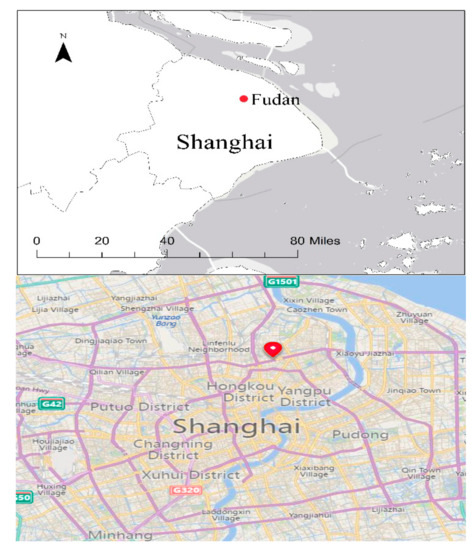
Figure 1.
The location of the MAX-DOAS instrument.
The measured scattered light spectra are analyzed using QDOAS software (Danckaert T, Fayt C, Van Roozendael M, De Smedt I, Letocart V, Merlaud A, Pinardi G.; Version 2.109; Royal Belgian Institute for Space Aeronomy (BIRA-IASB);Uccle, Belgium; 9 April 2015) to retrieve the differential slant column density (DSCD). The concentration of a given absorber integrated along the effective light path is relative to the amount of the same absorber in a measured reference spectrum (DSCD = SCD-SCDref) of O4, NO2, and HCHO. In order to remove the Fraunhofer lines in the solar spectrum, the reference spectrum chose the measured spectrum at solar zenith angle (SZA) = 13.2° at 12:00 LT (local time, LT = UTC + 8 h) on 4 August 2015. The following O4, NO2, HCHO DSCDs were determined by a DOAS fit in the wavelength range 337~370 nm, 411~435 nm, and 336~359 nm, respectively. Table 1 gives cross-sections used in DOAS fitting, and the absorption structure of Ring effect is calculated using QDOAS software in advance. In this paper, we only considered the data with high signal noise ratio (SNR), which refers to the DSCD data whose ratio of the obtained DSCD deviation by inversion to the DSCD is less than 0.2. Only data with root mean square (RMS) less than 1 × 10⁻⁴ were used. Based on the above criteria, 10% of the original data were removed.

Table 1.
The parameters of cross-sections and Ring effect in QDOAS.
Here, the clear sky condition was chosen as the experiment period during the entire observation period. Meena et al. (2004) [15] propose whether the O4 DSCD changes with the SZA show a smooth “U” feature that can be used to determine whether the weather is clear. According to the above method, the experiment period was selected from 6:00 to 18:00 LT in 28 July–5 August 2015. However, some afternoons were eliminated.
3. Retrieval Algorithm
Figure 2 is the flow chart for retrieving the extinction profile and tropospheric NO2 and HCHO VCD. There are three steps. First, a consistency check comparing the measured O4 DSCD with simulated O4 DSCD on clear-sky days with low aerosol load was conducted to obtain a correction factor. Second, a lookup table was used to retrieve the aerosol extinction coefficient profiles. Finally, the troposphere NO2VCD and HCHO VCD were inverted by using the two-step method. Here, the radiative transfer model SCIATRAN3.2 was used, and the temperature and pressure profiles from 0 to 30 km in the model have been replaced with sounding data from IGRA Shanghai (58,362) site to make the model closer to the actual situation.
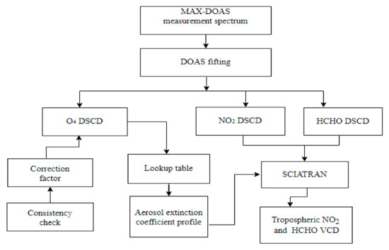
Figure 2.
Flow chart for the aerosol extinction coefficient profile and tropospheric NO2 and HCHO VCD retrieval process.
3.1. Consistency Check
Figure 3 illustrates the process of consistency check. The exponential aerosol extinction coefficient profiles calculated by MODISL2 AOD and scaling height of the tropospheric aerosol (Qiu et al., 2005) [16] are substituted into the model to produce simulated O4 DSCD on clear-sky days with low aerosol load. Comparing the measured and simulated O4 DSCD, we can get a correction factor to match them.

Figure 3.
Flow chart for the consistency check.
Through the analysis of MODISL2 AOD data, we found low aerosol situation appeared on 30 and 31 July 2015. Terra transited local at 10:15 LT on 30 July and at 11:00 LT on 31 July, and Aqua transited local at 13:00 LT on 30 July. So, we set up half-hour before and after the above three satellite transit times as A, B, C experiment periods in chronological order. From the MO DISL2 AOD data, the AOD of test A, B, C is 0.465, 0.54, 0.544, respectively. Xu et al. (2009) [17] reported that the average scaling height of the tropospheric aerosol was 2.5 km in Shanghai from 2001 to 2005, and the growth rate was 0.046 km·a-1 from 1961 to 2005. So, in this study, scaling height of the tropospheric aerosol is set to 2.8 km after extrapolation. According to the good agreement between the measured and simulated O4DSCDs at 15° and 30° elevation (Clémer et al., 2010) [18], we use 18° elevation for the experiment. The consistency check results of A, B, C experiment is illustrated in Figure 4, which displays the measured O4 DSCDs and shows they were systematically smaller than the simulated ones because the dependence of the O4 absorption cross-section on temperature is not very precise. The correction factor was about 1.5, namely DSCD corrected ≈ 1.5 × DSCD uncorrected. The correction factor of 1.5 is the ratio of the simulated value to the measured value. From now on, unless stated differently, the O4 DSCD mentioned in this paper refers to the corrected DSCD.

Figure 4.
Consistency check of A, B, C test: the model simulated DSCDs, measured DSCDs, and corrected DSCDs at 18° ELE. The red lines refer to the O4 DSCDs simulated by the SCIATRAN model, the blue lines represent the O4 DSCDs measured by the MAX-DOAS instrument, and the black lines are the measured O4 DSCDs multiplied by the correction factor.
3.2. Aerosol Inversion
Figure 5 is the flow diagram of retrieval aerosol optical properties using the lookup table method. First, we assumed that aerosol particles were homogeneous in the boundary layer, while in the free troposphere it decreases exponentially with height. This type of aerosol profile can be described with a limited set of parameters.
where E(z,λ) is the aerosol extinction coefficient with wavelength λ at height z, H denotes the boundary layer height, τ(λ) is Tropospheric aerosol optical depth, F is the fraction of the τ(λ) residing in the boundary layer, β(λ) is the normalization factor, and ξ is the scaling height for aerosol.

Figure 5.
Flow diagram of aerosol optical properties retrieval using a lookup table.
The relation between E(z,λ) and τ(λ) is
The β(λ) can be calculated by
Based on Equations (1)–(3), the aerosol extinction coefficient profiles in different states can be obtained by using different configurations of H, τ(λ), F, β(λ) and ξ parameters (as shown in Table 2). Putting different profiles into the SCIATRAN model to produce O4 DAMF (DAMF is the difference between the tropospheric AMF in the off-axis direction and zenithal directions) can set up a lookup table for the relationship between aerosol parameters and O4 DAMF. It should be noted that relative to the version of Li et al., 2010 and 2013 [9,10], we used the geometric angle of the average time for the inversion to reduce the computation time. Then based on the O4 AMF sensitivity experiment to geometric angles, we interpolated the geometric angles reasonably to reduce the deviation between the average geometric angle and the measured geometric angle.

Table 2.
Parameters for the lookup table.
Figure 6 shows the variation and slope of O4 AMF with SZA at RAA = 90° and with RAA at SZA = 45°. For other angles, they have the same change trend and were not shown here. It can be seen from the figure that (1) the variation trend of off-axis direction and zenith direction is roughly the same, but the slope is different, so they need to be considered separately; (2) The slope of O4 AMF changes with SZA is one magnitude greater than RAA, so the interpolation scheme mainly considers the influence of SZA. The range of observation SZA from the MAX-DOAS instrument is from 10° to 80°. According to the result of the geometric angle sensitivity experiment, for the off-axis direction, we interpolated one time in average geometric angle when SZA is 40°~60°, and interpolated two times when it is 60° or more. For the zenith direction, it was interpolated one time every two times.
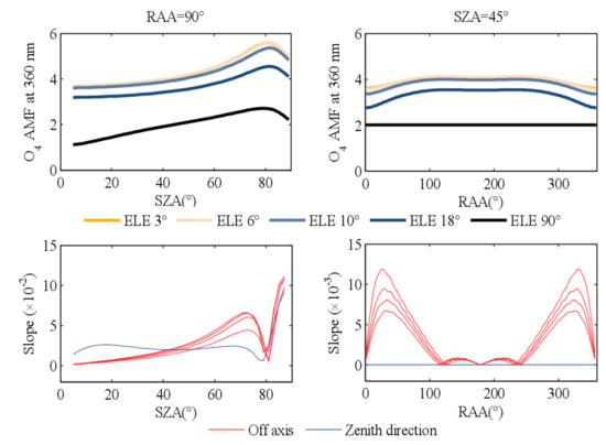
Figure 6.
The variation and slope of O4 AMF with SZA when RAA = 90° (left), and the variation and slope of O4 AMF with RAA when SZA = 45° (right). The slope graph indicates the slope of the O4 AMF change with SZA (left) and RAA (right), where the red lines refer to the off-axis direction and the blue lines indicate the zenith direction.
The measuredO4 DAMF in Figure 5 can be calculated by measured O4 DSCD and VCD. The VCD was 1.2 × 1043 melc 2·cm − 5. VCD can be calculated using temperature and pressure profiles from sounding data of IGRA Shanghai (58,362) site. The smallest χ2 using Equation (4) with a particular configuration can retrieve the aerosol extinction coefficient profile. In order to reduce atmospheric fluctuations and noise disturbances from single measurement, the was used in Equation (4), which is the hourly average of measured O4 DAMF. represents the standard deviation of the DAMF measured value, and represents the DAMF simulated value.
3.3. Trace Gas Inversion (NO2 and HCHO)
First, we define the tropospheric differential slant column densities (dSCD), which is the difference in slant column densities between off-axis direction and zenith direction. Then we assumed that the light path from the off-axis direction and the zenith direction is the same in the stratosphere, SCDstrat(α) = SCDstrat (90°), but the light path of the off-axis direction in the troposphere is much longer than the zenith direction. So, the tropospheric information can be approximated by subtracting the zenith direction information from the off-axis direction information.
4. Data Analysis
4.1. Aerosol
Figure 7 shows the diurnal variation of the aerosol profiles in Shanghai from 28 July to 5 August 2015. We inverted O4 DSCD in the wavelength range of MAX-DOAS, and then we inverted the 550 nm extinction coefficient using O4 DSCD in the radiative transfer model. Since the aerosol particles were mainly concentrated in the lower troposphere, we discuss the aerosol situation at 0~4 km, here. It can be seen that aerosol particles were mainly distributed on the boundary layer, and the diurnal variation of aerosol was clear. The aerosol content is low and mainly concentrated in the low layer in the morning, increasing gradually. The aerosol content of the whole layer was increased in the afternoon, and then gradually decreased. Within these nine days, the aerosol content was low on 30 and 31 July, and the aerosol content was high on 28–29 July and 1 August. At 15:00 on 29 July and at 13:00 on 1 August, the extinction coefficient content of low-level aerosols reached the maximum value of 2.0 km−1 in the nine days.
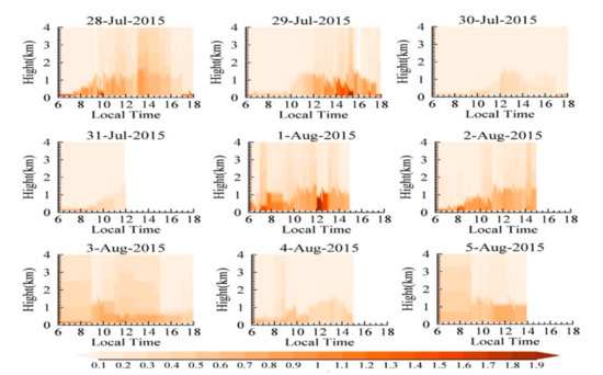
Figure 7.
Time series of aerosol extinction coefficient profiles (1~4 km) at 550 nm retrieved from MAX DOAS measurement in Shanghai from 28 July to 5 August 2015 (6:00~18:00 LT).
4.2. AOD and Boundary Layer Height
Figure 8 demonstrates the diurnal variation of the nine-day mean tropospheric AOD and boundary layer height. According to formula (1), when the aerosol extinction profile is obtained by the lookup table method, the AOD and boundary layer height can be obtained by inversion. The lowest value of AOD was happed at 6:00 LT, and AOD showed a little peak value at around early morning before 9:00 LT. AOD increased from the morning to the afternoon gradually, reaching the 2.0 maximum value at 13:00~14:00 LT, and then decreased with a rising at 17:00~18:00 LT. The highest AOD in the afternoon was due to the heating condition of solar energy being strongest at that time. The temperature of near-surface atmosphere rising can result in unstable convection and turbulent vertical transport. The two submaximal peaks appearing at 8:00~9:00 LT and 17:00~18:00 LT were matched with morning-evening rush hours. This shows that the influence of the coupling feedback of polluted gas-radiation-thermodynamics-dynamic-troposphere circulation on the secondary aerosol particles. The height of the boundary layer also had a distinct characteristic of daily change. It increased in the morning with radiation intensity and temperature augmentation and reached the maximum at noon. It then decreased with the decrease of the solar altitude and the temperature.
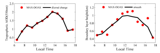
Figure 8.
Diurnal variation of AOD and boundary layer height in Shanghai from 28 July to 5 August 2015 (6:00~18:00 LT). The red dots indicate the tropospheric AOD, and boundary layer height retrieved by MAX-DOAS through the lookup table method.
4.3. Tropospheric NO2 and HCHO Vertical Column Densities
The retrieved tropospheric NO2 and HCHO vertical column densities in Shanghai from 28 July to 5 August 2015 are displayed in Figure 9. The NO2 diurnal variation pattern had its valley value at around noon, namely concave feature. The NO2 minimum value was caused by its photolysis rate reaching the maximum at noon due to strong solar radiation. The high value of tropospheric NO2 VCDs matched with traffic peaks, and 1 and 2 August is the weekend, but the weekend effect is not obvious. The tropospheric HCHOVCDs increased volatility in the morning and decreased in the afternoon showing a weak convex feature.
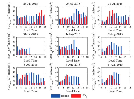
Figure 9.
Time series of tropospheric vertical column densities of NO2 and HCHO retrieved from MAXDOAS measurement in Shanghai from 28 July to 5 August 2015(6:00~18:00 LT).
4.4. Comparision to Satellite Products
In order to verify the accuracy of the MAX-DOAS technique inversion, we compared the retrieved tropospheric NO2 and HCHO VCD with GOME-2 and OMI satellite products. Here, the seven tropospheric NO2 VCD satellite products were used, namely GOME-2/MetOp-A/NASA, GOME-2/MetOp-B/NASA, GOME-2/MetOp-A/TEMIS, GOME-2/MetOp-B/TEMIS, OMIL2/NASA, OMIL2ovp/NASA, and OMI/TEMIS. Three kinds of tropospheric HCHO VCD satellite products were applied, which are GOME-2/MetOp-A/NASA, GOME-2/MetOp-B/NASA, and OMIL2/NASA.
In Figure 10, the comparison of retrieved NO2(a) and HCHO(b) with satellite products are shown. As can be seen, the retrieved results are significantly higher than satellite products. The multiple of retrieved NO2 (HCHO) and corresponding satellite products is 1~5 (1~3), and the average multiple is 2.37 (1.57). The results of Li et al. 2013 show that the NO2 VCD measured by OMI is about 20% to 50% higher than the NO2 VCD inverted by MAX-DOAS. Previous studies have shown that the NO2 VCD measured by OMI is about 10% to 50% lower than that of ground-based measurements. Combined with our research, it is shown that the VCD content is related to the distribution of pollutants at the observation site. In the paper, the reason for the retrieved results being on the high side may be that the experimental site is located in a heavily traffic-contaminated area in Shanghai, since spatial resolution of the satellite product is low. The area contained the range of 50 km centered on the experimental site, which not only include heavily polluted areas, but also involve low pollution areas. Moreover, the unconsidered trace gas would influence the accuracy of retrieval results, which is too high during the spectral data analysis process by QDOAS.
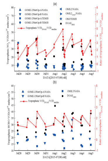
Figure 10.
Comparison of concentrations of (a) NO2 and (b) HCHO tropospheric vertical column densities retrieved by MAX-DOAS technique with satellite products. The black dots represent the tropospheric NO2 and HCHO VCDs retrieved by DOAS, the blue dots represent the tropospheric NO2 and HCHO VCDs from the satellite products, and the red dots represent the ratio of the tropospheric VCDs retrieved by DOAS to the tropospheric VCDs from the satellite products.
Figure 11 shows that the linear correlation between satellite products and retrieved results. Among them, there were three satellite products having a positive correlation with the retrieved NO2, as shown in Figure 11a–c, while the retrieved HCHO and all its satellite products were a linear positive correlation, as seen in Figure 11d–f. The correlation coefficients between retrieved NO2 tropospheric VCDs and satellite products of GOME-2/MetOp-B/NASA, GOME-2/MetOp-B/TEMIS, and OMI/TEMIS were 0.5172, 0.8449 and 0.5223, respectively. The correlation coefficients between retrieved HCHO tropospheric VCDs and satellite products of GOME-2/MetOp-A/NASA, GOME-2/MetOp-B/NASA, and OMI/NASA were 0.8632, 0.8896, and 0.3453, respectively. Because the samples of each satellite product are different in the correlation analysis process, it is impossible to tell which satellite product is closer to the retrieved result.
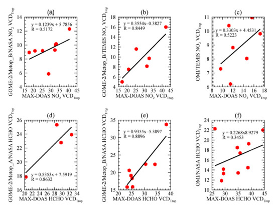
Figure 11.
Correlation analysis of NO2 tropospheric VCD satellite products from (a) GOME-2/MetOp-B/NASA; (b) GOME-2/MetOp-B/TEMIS; (c) OMI/TEMIS and retrieved results, Correlation analysis of HCHO tropospheric VCD satellite products from (d) GOME-2/MetOp-A/NASA; (e) GOME-2/MetOp-B/NASA; (f) OMIL2/NASA and retrieved results (unit: 1015 molec·cm−2).
4.5. A Cause Analysis of Aerosol Reduced and Recovered Process
A process that aerosol content reduced firstly and then recovered from 29 July to 1 August is shown in Figure 7. In general, local aerosol content is related to near-surface particulate matter concentrations and meteorological elements (wind is the main factor). The local atmospheric stability also can affect the accumulation of pollutants when chemical factors were not considered. We obtained PM air quality monitoring data from Hongkou Environmental Monitoring Station (3.5 km from the observation point), and meteorological element data from Weather Ground Meteorological Company and IGRA sounding data. The effects of aerosol were explored from the near-surface particulate concentration, wind direction and speed, and inversion layer, as shown in Figure 12.
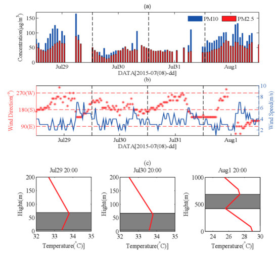
Figure 12.
Diurnal variation of (a) PM10 and PM2.5, (b) wind direction and wind speed in Shanghai from 28 July to 5 August 2015, and (c) Inversion layer at 20:00 on 29 July, 30 July, and 1 August.
Figure 12a is the diurnal variation of near-surface PM10 and PM2.5 in Shanghai from 29 July to 1 August. We can see that the PM10 and PM2.5 concentrations were low on 30 and 31 July and then recovered on 1 August. So, comparing with the aerosol situation in Figure 7, the PM10 and PM2.5 concentrations matched with aerosol content, indicating the higher the particulate matter concentration, the higher the aerosol content. Figure 12b is the diurnal variation of wind direction and wind speed in this process. From 29 July to 30 July, low aerosol content is shown when winds mainly blew from the east and southeast, because the cleaner air came from the south and southeast sides of Shanghai. On 1 August, high aerosol was prominent with southwest and west wind because heavy pollution area is situated to the southwest of the observation site.
Figure 12c shows the inversion layer occurred during this process. There are inversion layers below 60 m at 20:00 LT on 29 July and 30 July, which inversion intensities were 0.656 and 0.345, respectively. There was no inversion layer on 31 July, and an inversion layer whose inversion intensity was 0.687 appeared at 420 m to 680 m at 20:00 LT on 1 August. So, the inversion layer was related to the aerosol content, that aerosol content decreased (increased) when the inversion layer weakened (enhanced), by analyzing the relationship between the inversion layer with this aerosol process.
4.6. Study on Chemical Sensitivity of Local Ozone Production
We used the ratio of tropospheric HCHO and NO2VCDs to explore the chemical sensitivity of local ozone production (PO3). The ratio was less than 1, which indicates this area was at a VOCs-limited condition. When the ratio is between 1 and 2, the PO3 was at a mixed VOC-NOx-limited regime. The ratio was larger than 2 with NOx-limited condition of PO3 (Duncan et al., 2005) [19]. Figure 13 shows the ratio which indicated the PO3 in Shanghai during nine days. The ratio of tropospheric HCHO and NO2VCDs had a daily change during the experiment period. The ratio was near one with a slight decrease from 6:00 LT to 10:00 LT. The ratio from 10:00 to 13:00 increased significantly and the maximum value can reach three, and then gradually decreased after 13:00. During the nine-day experimental period, PO3 in one day can be summarized as follows: VOCs-limited condition--mixed VOC-NOx-limited regime—NOx-limited condition—mixed VOC-NOx-limited regime—VOCs-limited condition. This diurnal variation pattern of PO3 correlated with the daily change of HCHO, NO2 tropospheric VCDs.
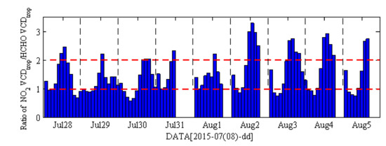
Figure 13.
The ratio of tropospheric HCHO and NO2 vertical column densities in Shanghai from 28 July to 5 August 2015 (6:00~18:00 LT).
5. Conclusions
Aerosol extinction profiles at 550 nm were retrieved using multi-axis differential optical absorption spectroscopy and a lookup table/. Then the tropospheric NO2 and HCHO vertical column densities were retrieved by applying a two-step method from 28 July 2015 to 5 August 2015 in Shanghai. The results show that the aerosol in summer in Shanghai will increase in the afternoon, and the tropospheric NO2 and HCHO VCD have concave and convex structures, respectively. The retrieved tropospheric NO2 and HCHO VCDs are significantly higher than satellite products. Wind direction and inversion layer can influence the aerosol pollution process. PO3 has an obvious diurnal variation during the experimental period.
The lookup table used in this paper can retrieve the aerosol extinction coefficient profile accurately. The O4 AMF sensitivity experiment to the geometric angle can be used to optimize the geometrical angle configuration in the lookup table. However, the aerosol profile shape setting is too single and needs further optimization.
Author Contributions
Conceptualization, K.Y. and W.W. (Weiguo Wang); methodology, W.W. (Wanlin Wei); software, K.Y.; validation, K.Y., H.W. and W.W. (Wanlin Wei); formal analysis, H.C.; investigation, J.B.; resources, K.Y.; data curation, X.T. and H.W.; writing—original draft, X.T.; preparation, K.Y.; writing—review and editing, W.W. (Wanlin Wei); visualization, H.W.; supervision, K.Y.; project administration, H.W.; funding acquisition, All authors have read and agreed to the published version of the manuscript.
Funding
This research was funded by [Second Tibetan Plateau Scientific Expedition and Research Program (STEP)] grant number [2019QZKK0604]; funded by [National Science Fund for Distinguished Young Scholars and the National Natural Science Foundation of China] grant number [41825011, 41807308, 21777026, 41641044, and 21477021]; funded by [Open Project of Shanghai Key Laboratory of Atmospheric Particle Pollution and Prevention (LAP3)] grant number [FDLAP19009].
Institutional Review Board Statement
“Not applicable” for studies not involving humans or animals.
Informed Consent Statement
Informed consent was obtained from all subjects involved in the study.
Data Availability Statement
The data are not publicly available due to the data will be used in future studies.
Acknowledgments
Thanks to the observations data of the MAX-DOAS instrument provided by Fudan University. The QDOAS software we used for DOAS analysis is provided by the Belgian Institute for Space and Aeronomy (IASB/BIRA). Furthermore, we would like to thank the Institute of Environmental Physics (IUP) and Remote Sensing (IFE) at Bremen University, which provide the SCIATRAN model. We also acknowledge the free use of tropospheric NO2 and HCHO column data from NASA and TEMIS. This work was supported by the “Second Tibetan Plateau Scientific Expedition and Research Program (STEP)” (grant no. 2019QZKK0604), the National Science Fund for Distinguished Young Scholars and the National Natural Science Foundation of China (grant nos. 41825011, 41807308, 21777026, 41641044, and 21477021), and the Open Project of Shanghai Key Laboratory of Atmospheric Particle Pollution and Prevention (LAP3) (grant no. FDLAP19009).
Conflicts of Interest
The authors declare no conflict of interest.
References
- Platt, U.; Stutz, J. Differential Absorption Spectroscopy. Phys. Earth Space Environ. 2008, 29, 2458–2462. [Google Scholar]
- Irie, H.; Takashima, H.; Kanaya, Y.; Boersma, K.F.; Gast, L.; Wittrock, F.; Brunner, D.; Zhou, Y.; Roozendael, M.V. Eight-Component Retrievals from Ground-Based MAX-DOAS Observations. Atmos. Meas. Tech. 2011, 4, 1027–1044. [Google Scholar] [CrossRef] [Green Version]
- Cracknell, A.P.; Varotsos, C.A. New Aspects of Global Climate-Dynamics Research and Remote Sensing. Int. J. Remote Sens. 2011, 32, 579–600. [Google Scholar] [CrossRef]
- Varotsos, C.; Ondov, J.; Tzanis, C.; Öztürk, F.; Nelson, M.; Christodoulakis, J. An Observational Study of the Atmospheric Ultra-Fine Particle Dynamics. Atmos. Environ. 2012, 94, 312–319. [Google Scholar] [CrossRef]
- Varotsos, C.; Tzanis, C.; Cracknell, A. The Enhanced Deterioration of the Cultural Heritage Monuments Due to Air Pollution. Environ. Sci. Pollut. Res. Int. 2009, 16, 590–592. [Google Scholar] [CrossRef] [PubMed]
- Wang, Y.; Li, A.; Xie, P.H.; Chen, H.; Mou, F.S.; Xu, J.; Wu, F.C.; Zeng, Y.; Liu, J.G.; Liu, W.Q. Measuring Tropospheric Vertical Distribution and Vertical Column Density of NO2 by Multi-Axis Differential Optical Absorption Spectroscopy. Acta Phys. Sin. 2013, 62, 000138–151. [Google Scholar] [CrossRef]
- Wang, Y.; Li, A.; Xie, P.H.; Chen, H.; Xu, J.; Wu, F.C.; Liu, J.G.; Liu, W.Q. Retrieving Vertical Profile of Aerosol Extinction by Multi-Axis Differential Optical Absorption Spectroscopy. Acta Phys. Sin. 2013, 62, 180705. [Google Scholar] [CrossRef]
- Wagner, T.; Beirle, S.; Brauers, T.; Deutschmann, T. Inversion of Tropospheric Profiles of Aerosol Extinction and HCHO and NO2 Mixing Ratios from MAX-DOAS Observations in Milano during the Summer of 2003 and Comparison with Independent Data Sets. Atmos. Meas. Tech. 2011, 4, 2685–2715. [Google Scholar] [CrossRef] [Green Version]
- Li, X.; Brauers, T.; Shao, M.; Garland, R.M.; Wagner, T.; Deutschmann, T.; Wahner, A. MAX-DOAS Measurements in Southern China: Retrieval of Aerosol Extinctions and Validation Using Ground-Based In Situ Data. Atmos. Chem. Phys. 2010, 10, 2079–2089. [Google Scholar] [CrossRef] [Green Version]
- Li, X.; Brauers, T.; Hofzumahaus, A.; Lu, K.; Li, Y.P.; Shao, M.; Wagner, T.; Wahner, A. MAX-DOAS Measurements of NO2, HCHO and CHOCHO at A Rural Site in Southern China. Atmos. Chem. Phys. 2013, 13, 2133–2151. [Google Scholar] [CrossRef] [Green Version]
- Wagner, T.; Dix, B.; von Friedeburg, C.; Frieß, U.; Sanghavi, S.; Sinreich, R.; Platt, U. MAX-DOAS O4 Measurements: A New Technique to Derive Information on Atmospheric Aerosols—Principles and Information Content. J. Geophys. Res. Earth Surf. 2004, 109, D22205. [Google Scholar] [CrossRef] [Green Version]
- Vlemmix, T.; Hendrick, F.; Pinardi, G.; De Smedt, I.; Fayt, C.; Hermans, C.; Piters, A.; Wang, P.; Levelt, P.; Van Roozendael, M. MAX-DOAS Observations of Aerosols, Formaldehyde and Nitrogen Dioxide in the Beijing Area: Comparison of Two Profile Retrieval Approaches. Atmos. Meas. Tech. 2015, 8, 941–963. [Google Scholar] [CrossRef] [Green Version]
- Irie, H.; Boersma, F.; Kanaya, Y.; Takashima, H.; Xiaole, P.; Wang, Z. Quantitative bias estimates for tropospheric NO2 columns retrieved from SCIAMACHY, OMI, and GOME-2 using a common standard for East Asia. In Proceedings of the AGU Fall Meeting, San Francisco, CA, USA, 3–7 December 2012; pp. 2403–2411. [Google Scholar]
- Wang, S.S. Study on the Retrieval of NO2 and Aerosol Pollution in Shanghai Urban Area Based on the Passive DOAS Technique. P.D. Thesis, Fudan University, Shanghai, China, 2012. [Google Scholar]
- Meena, G.S.; Bhosale, C.S.; Jadhav, D.B. Influence of Tropospheric Clouds on Ground-Based Measurements of Stratospheric Trace Gases at Tropical Station, Pune. Atmos. Environ. 2004, 38, 3459–3468. [Google Scholar] [CrossRef]
- Qiu, J.; Zong, X.; Zhang, X. A Study of the Scaling Height of the Tropospheric Aerosol and Its Extinction Coefficient Profile. J. Aerosol Sci. 2005, 36, 361–371. [Google Scholar] [CrossRef]
- Xu, X.F.; Qiu, J.H.; Niu, S.J.; Tang, L.L. Optical Depth of Atmospheric Aerosol at 12 Stations in China over the Past 45 Years. Acta Sci. Circumstantiae 2009, 29, 488–495. [Google Scholar]
- Clémer, K.; Roozendael, M.V.; Fayt, C.; Hendrick, F. Multiple Wavelength Retrieval of Tropospheric Aerosol Optical Properties from MAXDOAS Measurements in Beijing. Atmos. Meas. Tech. Discuss. 2010, 3, 863–878. [Google Scholar] [CrossRef] [Green Version]
- Duncan, B.N.; Yoshida, Y.; Olson, J.R.; Sillman, S.; Martin, R.V.; Lamsal, L.; Hu, Y.; Pickering, K.E.; Retscher, C.; Allen, D.J. Application of OMI Observations to A Space-Based Indicator of Nox and VOC Controls on Surface Ozone Formation. Atmos. Environ. 2010, 44, 2213–2223. [Google Scholar] [CrossRef] [Green Version]
Publisher’s Note: MDPI stays neutral with regard to jurisdictional claims in published maps and institutional affiliations. |
© 2022 by the authors. Licensee MDPI, Basel, Switzerland. This article is an open access article distributed under the terms and conditions of the Creative Commons Attribution (CC BY) license (https://creativecommons.org/licenses/by/4.0/).