Review

Precision Oliviculture: Research Topics, Challenges, and Opportunities—A Review

Department of Agricultural, Food and Forest Sciences, University of Palermo, 90128 Palermo, Italy
*
Author to whom correspondence should be addressed.
Remote Sens. 2022, 14(7), 1668; https://doi.org/10.3390/rs14071668
Submission received: 27 January 2022 / Revised: 2 March 2022 / Accepted: 22 March 2022 / Published: 30 March 2022
(This article belongs to the Special Issue Advances of Remote Sensing in Precision Agriculture)

Abstract

:
Since the beginning of the 21st century, there has been an increase in the agricultural area devoted to olive growing and in the consumption of extra virgin olive oil (EVOO). The continuous change in cultivation techniques implemented poses new challenges to ensure environmental and economic sustainability. In this context, precision oliviculture (PO) is having an increasing scientific interest and impact on the sector. Its implementation depends on various technological developments: sensors for local and remote crop monitoring, global navigation satellite system (GNSS), equipment and machinery to perform site-specific management through variable rate application (VRA), implementation of geographic information systems (GIS), and systems for analysis, interpretation, and decision support (DSS). This review provides an overview of the state of the art of technologies that can be employed and current applications and their potential. It also discusses the challenges and possible solutions and implementations of future technologies such as IoT, unmanned ground vehicles (UGV), and machine learning (ML).

1. Introduction

Precision agriculture represents one of the most important opportunities that can be implemented by companies in order to ensure quantitatively and qualitatively satisfactory productions [1,2]. Recently, the International Society of Precision Agriculture (ISPA) released this definition:
“Precision Agriculture is a management strategy that gathers, processes and analyses temporal, spatial and individual data and combines it with other information to support management decisions according to estimated variability for improved resource use efficiency, productivity, quality, profitability and sustainability of agricultural production.”
Precision farming (PF) is a management method that aims to investigate the spatial and temporal variability of an agroecosystem in order to carry out site-specific treatments, applying different technologies and methodologies. The intra- and inter-crop variability that occurs within the crop is determined by the spatial and temporal variability of the soil, the crop species, and the climate [3]. The main advantages of this practice include: savings on the quantity of inputs used [4,5], lower environmental impact [6], higher crop productivity, and product quality. Its application is widely carried out in herbaceous crops and, to a lesser extent, in tree crops, where PF is mainly applied in viticulture, as it succeeds in achieving the best combination of production quality, environmental impact, and costs [7].
In recent years, there has been an increase in the agricultural area devoted to olive growing and in the consumption of extra virgin olive oil (EVOO) [8]. In addition, a continuous change in cultivation techniques has been observed, which poses new challenges to ensure the environmental and economic sustainability of olive farms [9]. Today, the olive tree is cultivated in about 40 countries and occupies a global area of about 10.5 million hectares [8]. Its cultivation is almost entirely (over 98%) in countries bordering the Mediterranean Sea, where olive growing has always been a traditional practice and a descriptive element of many landscapes in rural and peri-urban areas [10]. However, it is also continuously expanding in other continents, such as Australia and South America [8]. The world olive system is divided into three forms of cultivation: traditional olive cultivation (OT), intensive (HI) or high intensity (HD) olive cultivation, and superintensive (SHI) or very high density (SHD) olive cultivation [11,12]. These three major classes are profoundly different in cultivation techniques and require appropriate agronomic choices for a successful crop.
These techniques are able to modify the vegetative and productive activity of the olive tree and require appropriate choices depending on the agro-climatic context. These include phytosanitary management, irrigation, soil management, pruning, fertilization, etc. However, the most important agronomic practices that need to be different depending on the type of cropping system in which precision farming can allow a clear improvement are fertilization and irrigation.
Fertilization can directly and indirectly influence the vegetative-productive activity of plants and the whole agrosystem. Such application proves to be beneficial in terms of productivity and quality (size, oil content, etc.) when the foliar nutrient concentration is below the threshold [13,14,15]. However, this practice is often carried out without considering the real needs of the crop, the real availability, and the soil characteristics [16]. In fact, excessive doses are used with a consequent increase in vegetative activity to the detriment of productivity (to this condition the olive tree is very sensitive, manifesting itself with a clear alternation of production), increased management costs, pollution [13], etc. Furthermore, the use of massive doses of fertilizer leads to a deterioration in oil quality [17,18,19], due to a reduction in polyphenol content [20] without any increase in oil yield.
Irrigation, more than any other agronomic practice, is capable of modifying the quality and quantity of the fruit [21]; unfortunately, it is difficult to reach the right compromise. In fact, there can be negative effects on fruit quality such as a reduction of the phenolic component (excessive doses) and on productivity (lower doses). On the other hand, the positive effects are linked to an increase in production and a reduction in production alternation. The olive tree is a species that has always been recognized as resistant–tolerant to water stress with an average water requirement of 1500–2500 m3 ha−1. For this reason, in traditional systems it is grown without the aid of irrigation [22]. Unfortunately, the new SHD farming systems, characterized by higher productivity, cannot be managed without the use of this agronomic practice. Moreover, the water resource is decreasing due to its continuous exploitation. Therefore, it is evident that it is necessary to use techniques and agronomic choices able to maximize crop water efficiency (WUE). This objective can be pursued in different ways: acting on the quantity of water supplied, acting differently on the different phenological moments, acting on the methods of irrigation distribution (micro-flow, sprinkling, etc.), and/or through the right agronomic choices (pruning, fertilization, etc.). However, in order to achieve this, the water status of the crops must be measured accurately and reliably in order to provide a predetermined stress level. In this perspective, precision irrigation can provide excellent results on the identification of water stress variability in the field [21].
In short, the profound differences between farming systems and the different repercussions that agronomic practices can have on them pose new challenges and problems in successfully transferring and applying precision agriculture to this agronomic system. The aim of this work was to provide state of the art studies carried out on the application of precision farming to olive growing, in its different forms (OT, HD, and SHD), and to illustrate its potential applications. The research was done thoroughly by examining the existing literature work done in the context.

2. Remote Sensing Sensors for Spatial Variability Detection

The first step in precision agriculture is the investigation of spatial variability, using different types of sensors capable of acquiring raster or vector information [23]. As reported by Zhang et al. (2002) [23], the variability affecting agricultural production can be classified into six groups: yield variability; field variability; soil variability; crop variability; variability related to abnormal factors; and management variability. The sensors used for this purpose are capable of acquiring information of different kinds and cover a more or less wide area. In order to be able to apply them in the best possible way, it is necessary to know the variable to be investigated and the acquisition platform on which they will be placed. In fact, the same sensor, such as a multispectral camera, can be used on remote or proximal sensing platforms and give very different information. In this article, we focus on the sensors that are the most used in remote sensing of olive trees as they are the most used in precision farming. Generally, these sensors are cameras capable of acquiring images (raster information) in different multispectral bands. Their use differs according to the spatial, spectral, radiometric, and temporal resolution they offer. The spatial resolution of a sensor is defined by the size of the pixel representing the investigated area. Spectral resolution is indicated by the width of the spectral bands of the acquired electromagnetic spectrum. Radiometric resolution represents the number of different signal intensities that the sensor is able to acquire; the measurement scale is expressed in bits and generally ranges from 8 to 16. Temporal resolution is associated with the platform hosting the sensor rather than the sensor itself and represents the time between one acquisition and the next of the same object [24]. There are many classifications of sensors that can be used remotely, as they can be distinguished based on their operation, type of acquisition, number of acquisition bands (multispectral and hyperspectral), and more. In remote sensing, RGB, hyperspectral, and multispectral images are generally present as sources of spectral information. However, these provide different information, so it is necessary to understand their actual potential. In precision olive growing, multispectral images represent the most widely used spectral information. In this article, the classification was made on the basis of the main crop characteristics (nutritional, water, and canopy structural status) that can be investigated by remote sensors on olive trees in the literature.

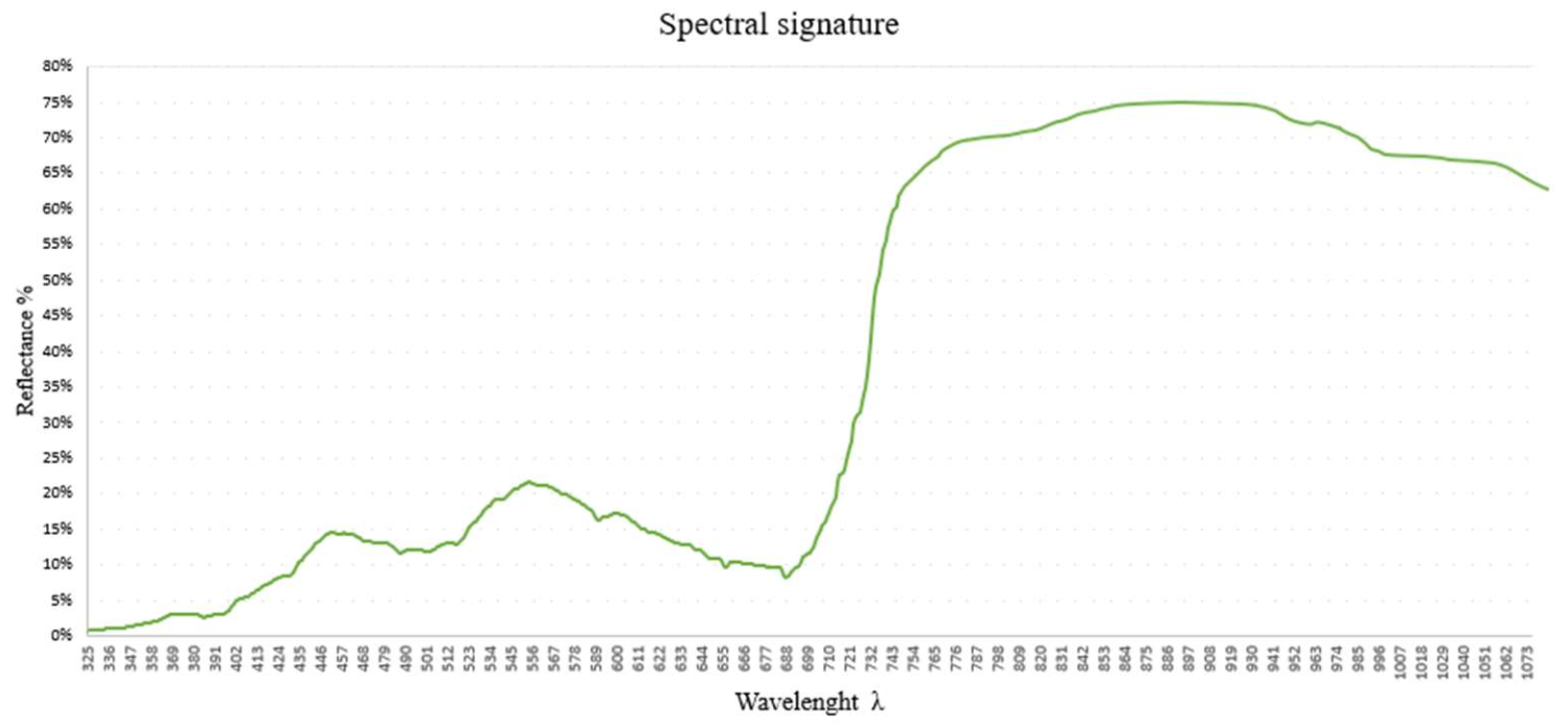
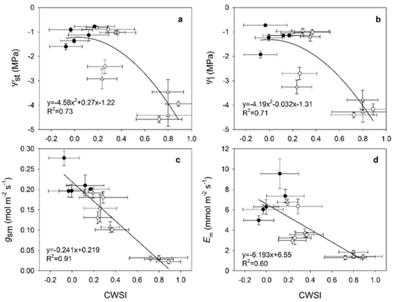
2.1. Sensors and Technologies for Identifying the Physiological State of the Olive Tree

For the identification of nutritional deficiencies, canopy structural information, water status of olive trees, and more generally plant health conditions, sensors capable of detecting the electromagnetic energy reflected or emitted by plants are used in precision agriculture [25]. This is because leaf reflectance is influenced by several factors (presence or absence of particular molecules, environmental factors, etc.) in specific regions of the electromagnetic spectrum, such as: in the visible wavelengths by photosynthetic pigments such as chlorophyll a, chlorophyll b, and carotenoids; in the near-infrared by leaf structure (size and distribution of air and water inside the canopy), and the presence of water and biochemical substances such as lignin, cellulose, starch, proteins, and nitrogen [26]. Therefore, this optical technique is based on measuring the reflectance of incident electromagnetic radiation at different wavelengths in the range from 350 to approximately 25,000 nm. This range includes the frequency bands most commonly used in precision farming, such as: visible (VIS), near-infrared (NIR), shortwave infrared (SWIR), and thermal infrared (TIR). The set of spectral responses of a crop at high spectral resolution (narrow bands) allows its spectral signature to be identified. The spectral signature is typical for each crop and each stress situation (Figure 1).
The reflectance curves of olive tree leaves show the same spectral pattern typical of the main agricultural crops [26] for all measured wavelengths, although the magnitude and amplitude varied especially in the NIR region (750–1100 nm) due to different crop characteristics such as canopy structure, water content, etc. In the study by Rubio–Delgado et al. (2021) [25] the reflection curves showed different reflection peaks and absorption sinks. In the VIS region, one reflection peak was centered at 554 nm (green region) and two absorption sinks were centered at 390 and 680 nm (blue and red regions, respectively). The NIR region had a higher reflection than the VIS region. In the SWIR region (1100–2300 nm), three absorption wells were identified as: 1200, 1450, and 1720 nm, and three reflection peaks centered at 1280, 1650, and 2200 nm [25]. Thus, the most suitable electromagnetic spectrum regions for characterizing the absorption spectrum of olive trees are between 350–1350, 1421–1800, and 1961–2300 nm. The first two represent the electromagnetic regions of greatest interest as they are used to investigate the nitrogen and chlorophyll content and some structural properties of the canopy. The absorption regions of the band are caused by the presence of water and have a high presence of noise, resulting in a low signal-to-noise ratio [27]. Therefore, alterations in photosynthetic activity are related to the nutritional status, health, and vigor of plants, and can be easily detected with multispectral and hyperspectral sensors [28].
Since the 1980s, the first vegetation indices (VI) have been created to examine growing conditions. These are calculated from the individual reflectance value wavelengths acquired. These are classified into two large families: slope-based and distance-based [29]. In addition to their simple use, several processing techniques have also been experimented with in order to obtain greater precision and information of vegetation indices such as smooting (SM), partial least squares regression (PLSR) techniques, etc. Using PLSR techniques, it is possible to extrapolate spectral information of the crop from the entire reflectance spectrum (350–2500 nm) [30]. In olive trees, the most widely used VI (Table 1) are probably the normalized difference vegetation index (NDVI) and the soil-adjusted vegetation index (SAVI). However, there have not yet been exhaustive studies in the field that have determined their real potential for use in stress discrimination. Given the high sensitivity of Vis to variations in chlorophyll content, nitrogen, and plant nutritional status, their application has focused on precision fertilization techniques [31,32,33] and precision irrigation [21].
Regarding the ability and aptitude of the different IAs to discriminate and investigate the nutritional status of the olive tree, there are not many studies; moreover, they seem to be in slight contrast. Gómez–Casero et al. (2007) [38] showed that N and K deficiencies can be discriminated using about 26 different wavelengths, and the best indices were: NIR/G, G/R, and NDVI. In general, the best wavelengths for the calculation of VI were between 830 and 890 nm (mainly in the NIR region) for both nutrients. Noguera et al. (2021) [40] viewed the reflectance curve, in the VIS-NIR region, of olive trees under different treatments of nitrogen, phosphorus, and potassium. Their results showed that potassium and phosphorus had a similar pattern with peaks evident at 550 and 700 nm and to a lesser extent at 670 nm; in the case of N, they were not significant. Furthermore, using different methods of data analysis they found that non-parametric analysis (ANN, neural network analysis) generated the best prediction of leaf element concentration.
The study by [25] contributed significantly to the evaluation of the spectral characteristics of olive leaves with the aim of estimating the nutritional status of this crop. All the wavelengths used gave a low predictive capacity for leaf nitrogen content. The best results of the VI used in Rubio–Delgado et al. (2021) [25] were provided by the indices: double-peak canopy nitrogen index (DCNI, r2 = 0.72), modified chlorophyll absorption in reflectance index (MCARI, r2 = 0.53), and transformed chlorophyll absorption ratio index (TCARI, r2 = 0.64). The best vegetation index was DCNI, with a correlation of 0.72, combining the following wavelengths: 395, (blue); 652 (red), and 1275 nm (SWIR). No index combining wavelengths from the NIR region presented a high coefficient of determination, underlining those combinations using blue, red, and SWIR wavelengths are the most suitable for estimating leaf nitrogen concentration (LNC) in olive trees using hyperspectral data. Furthermore, Rubio–Delgado et al. (2021) [25] processed the raw data with different methodologies in order to verify which one is the best for determining the LNC. The results showed that the raw data resulted in an increase in the correlation between VI and LNC, especially when second derivative and smoothing (SM) and/or standard normal variate (SNV) were used as a pre-processing method. The PLSR models produced very good accuracy compared to VI, although the uncertainties associated with noise in the hyperspectral data were higher. Similar results were obtained by Rotbart et al. (2013) [41] and Zarco–Tejada et al. (2004) [34]. Rotbart et al. (2013) [41] estimated the LNC using the same methodology (albeit in the laboratory) over a reduced reflection spectrum (SWIR was not considered). They conclude the work by stating that due to several confounding factors such as leaf orientation, water content, etc., it was not possible to build a robust model to be applied in the field.
Precision irrigation is currently more and more successful, also due to the high technology push and the gradual reduction of the cost of the necessary equipment in the last years [40]. However, it still remains a well implemented practice for different crops [42]. In precision oliviculture, this practice is under continuous experimentation, since the spatially variable application of water is advantageous for environmental, economic, and management sustainability (cost reduction, better balance between production and vegetation, and higher quality of the final product). Several techniques can be used to directly or indirectly determine the water status of the crop. The most widely used in precision oliviculture to investigate the entire variability of the field are thermography and/or the use of Vis closely linked to the crop’s water content.
The main advantage of using Vis for the identification of plant water conditions lies in the possibility of exploiting the wavelengths that are recorded with multispectral or better hyperspectral chambers, which are usually used for the identification of the correct nutritional and health status of crops. These Vis are based on reflectance spectroscopy in the electromagnetic regions of the visible (VIS), near infrared (NIR), and shortwave infrared (SWIR) and can be applied for indirect assessments of the water status of olive trees, as water content can greatly influence crop spectral signatures [37,43,44,45]. Recently, a specific database containing several indices related to “vegetation water” applications has been created and published online by the Institute of Crop Science and Resource Conservation (INRES, www.indexdatabase.de; 1 February 2022) of the University of Bonn. Unfortunately, the proposed indices are not related to any specific crop or physical variable.
Ref. [35] described the accuracy of several VIs and the use of partial least squares regression (PLSR) to determine leaf water potential (LWP). The best prediction was found using the moisture stress index (MSI) (RMSE = 0.72 and r2 = 0.45) and the normalized difference water index (NDWI, RMSE = 0.75 and r2 = 0.45). Using the PLSR technique, a good prediction of LWP was obtained at both tree canopy and leaf levels. However, this technique requires the availability of complete high-resolution spectra, which can only be obtained with portable spectroradiometers or hyperspectral remote sensors. Although the use of VI seems to have good applications in crop water stress management, high correlations are not always observed. This is because water stress is a condition that determines the change of the leaf structure and its spectral response but not always in the short term, and it is also linked to many other stress conditions such as nutrition and the management of the olive grove itself.
Even today, methodologies or techniques are proposed that use leaf temperature alone (in the case of olive trees, the range of stress variability is between 28–37 °C), to distinguish different levels of stress. Unfortunately, this poses numerous limitations due to the high influence of environmental conditions. For this reason, they are less used today, and it is preferred to use some normalized indices [46,47,48]. The main index that allows the evaluation of the water status of olive trees is the crop water stress index (CWSI). This index was invented by Jackson et al. (1981) [47] and Idso et al. (1981) [46] and can have a value ranging from 0 to 1, indicating stress and good irrigation conditions, respectively. It is determined from the temperature of the object (in this case the leaf temperature) at a given time (T0). This temperature is closely correlated with water stress, since the physical principle behind the temperature change depends on transpiration. In fact, the stomatal closure that occurs due to water stress causes less leaf transpiration (loss of water vapor), which in turn causes an increase in leaf temperature. From the different studies that have been found in the bibliography, we can state that CSWI has proven to be a good indicator of the crop’s water status as it presents very good correlations with canopy temperature and the different stress indices [42,49,50,51]. Egea et al. (2017) [50] correlated CSWI and the main water stress indicator parameters such as: stem water potential (Ψst), leaf water potential (Ψl), leaf transpiration rate (Em), and stomatal conductance (gsm), obtaining significant linear regressions (Figure 2).
The CWSI can be calculated from images acquired at wavelengths (λ) between 7–14 nm. The original formula that was proposed is as follows:
C S W I = d T d T l l d T u l d T l l
where dT is given by (Tc−Ta), i.e., the difference between the canopy temperature (Tc) and the air temperature (Ta); dTll is the No-Water Stressed Baseline (NWSB) of fully irrigated crops; and dTul is the upper baseline. The dTll and dTul are the temperature values of fully irrigated and water stressed crops respectively. The dTll and dTul are both a function of the atmospheric vapor pressure deficit (VPD) [46,52]. Both upper and lower limits are species-specific and can be derived. Unfortunately, the different published NWSB equations for olive are site-dependent, as the VPD normalization procedure used to obtain CWSI does not take into account differences in net radiation and drag that are known to influence this index. Furthermore, as shown by Egea et al. (2017) [50] the intercept and equation of the NWSB varies with stagione and time of day. In response to this, Berni et al. (2009) [42] proposed to calculate the NWSB empirically using the Tc-Ta values of trees from the full irrigation (FI) treatment near solar noon (12:30 GMT), using hourly mean values from clear days from April to September. Thus calculated, the NWSB (Tc-Ta = −0.35 − VPD + 2.08, r2 = 0.67) shows differences in Tc-Ta varying less than 1.5 K even with large variations in VPD. This difference is very small when compared to NWSB for herbaceous crops but also for some tree species such as pistachio and peach as well as the slope of the same, probably due to the high transpiration regulation capacity of olive trees [50,51,52,53,54,55].
Given the laboriousness, in olive trees, other calculation methods have also been identified for their determination. To eliminate the problem of knowing the NWSB, Jones (1999) [56] modified the CWSI and defined a new normalized CWSI, which is described as follows.
C S W I = T c a n o p y T w e t T d r y T w e t
where Tcanopy is actual canopy temperature obtained from the thermal image and Twet and Tdry are the lower and upper boundary temperatures representing a fully transpiring leaf with open stomata and a non-transpiring leaf with closed stomata, respectively. Note that Twet and Tdry are equivalent to dTll e dTul in the original formulation of CWSI by Idso et al. (1981) [46]. However, normalizing CWSI is a more complex process with changing atmospheric conditions than using VPD alone. Indeed, varying atmospheric conditions complicate the normalization of CWSI. In this regard, Tdry and Twet can be calculated using an empirical approach.
In the empirical approach, Tdry can be determined by adding 5 °C to the air temperature [57], while Twet can be determined by two methods. One of these involves the spraying part of the canopy with water some 20 s prior to thermal image acquisition [48] or by measuring the temperature of a wet artificial reference surface (WARS). As detailed by Cohen et al. (2005) [42] and Meron et al. (2003) [58], the WARS is a permanently wet surface of reproducible radiometric and physical properties, such a wet object, which can also take the form of an artificial wet cloth [58], with a typical size of 30 × 40 cm. Three main drawbacks limit the applicability of CWSIE for high spatiotemporal monitoring of stress [49,59]. The first is the empirical value of 5 °C. While it had indeed been proven to represent the maximum leaf temperature under several conditions [42,48,57], the CWSIE is quite sensitive to the value assigned to Tdry, and a significant uncertainty is induced to the index’s value when use of this empirical formulation is adopted. The second drawback is that it must necessarily be placed inside each thermal image acquired and the third required high-spatial resolution (to detect a significant number of pixels within the reference, while avoiding mixed pixels) [49]. For these reason, one analytical method can be used to calculate Tdry and Twet. It is quite expensive in terms of calculation. This method is based on the energy balance equation [56,60] and requires the measurement of incoming solar radiation, air temperature, relative humidity, drag, and wind speed [48]. These measurements are available from any meteorological station and can be representative of very large areas, but may have a degree of uncertainty that affects their accuracy. For the analytical calculation, an energy balance is performed to derive the net solar radiation (W m2), using the sum of incoming and outgoing radiation. The analytical form is proposed by Jones (CWSIA, [56]). This form has been used extensively in several studies in olive groves [49,61]. Berni et al. (2009) [61] developed an approach suitable for monitoring areas in the order of hundreds of hectares using an unmanned aircraft that could provide frequent visits and short lead times to detect water stress for irrigation scheduling. The methodology presented does not require the use of reference areas and relies on physical models to estimate all input variables of the energy balance equations. Berni et al. (2009) [61] calculated firstly the resistance of the canopy to heat transport (rc). The model used to calculate the CWSI considers not only the vapor pressure deficit but also Rn and wind speed, parameters known to influence temperature differences between air and tree canopy. Once the rc is known and the potential canopy resistance for a well-watered crop (rcp) is estimated [62,63], one can proceed with the calculation of the CWSI with a purely analytical solution, as reported below:
C S W I =   γ rc rcp ra Δ + γ   ( 1 + rcp ra
According to Ben–Gal et al. (2009) [49], a comparison of the two methodologies was carried out. The best of the two methods (analytical and empirical) turns out to be the CSWIA, although there are not clear differences. On the other hand, Agam et al. (2013) [59] obtained contrasting results with Ben–Gal et al. (2009) [49] as they showed that the use of CSWIE for the identification of the water status of olive trees during stress and recovery phase is better than the analytical one. Furthermore, Agam et al. (2013) [59] observed a poor applicability of CSWIA indices throughout the day, in contrast to CSWIE, which proved to be better able to differentiate well-watered trees from stressed trees and better represented the evapotranspirative trend of the crop. Agam et al. (2013) [59] proposed that the CSWIA can be used not so much for the estimation of the water status of the olive tree, but for an indirect estimation of the stomatal conductance, with which it is closely related.
Agam et al. (2013) [59] proposed the application of a new CSWI that is intermediate between the empirical and the analytical method, assuming that Twet is calculated analytically (Jones method), and thus overcoming one of the application limitations of CWSIE. Since Twet, calculated according to Jones (1999) [56], has been shown to produce good CWSI values, it is therefore proposed to combine CWSIA with CWSIE to form a CWSIAE. In the latter method, Tdry is determined empirically, while Twet is calculated analytically, using meteorological measurements in the field.
There is also another methodology to calculate CSWI that is used for satellite imagery [64]. This methodology turns out to be very similar to the use of CSWIE in that the image is calibrated based on the two references, hot and cold, present in the image. Veysi et al. (2017) [52], using this methodology, were able to determine the CWSI using only remote sensing satellite data, using the following equation:
C S W I = T s T c o l d T h o t T c o l d
where Ts is the land surface temperature (LST) derived from a satellite image providing the canopy temperature, Tcold is the temperature of the cold pixels, and Thot is the temperature of the hot pixels. Cold pixels are those covered by fully irrigated crops and hot pixels represent crops under water stress. Bastiaanssen et al. (1998) [65] described the correct procedure for selecting hot and cold pixels while Veysi et al. (2017) [52] made some modifications for selecting hot pixels. Hot pixels are selected from the area with maximum water stress while LST is calculated using thermal images. The LST calculation requires an image with no cloud cover or atmospheric correction of it, radiometric calibration, and knowledge of the emissivity of the considered surface. These are challenging tasks; moreover, existing terrestrial observations (EO) do not provide TIR images with detailed temporal and spatial resolution, and do not appear to be able to adequately distinguish individual canopies [64,66,67]. Fuentes–Peñailillo et al. (2018) [68] also proposed an intermediate methodology to be applied on remote stellar platforms to the Shuttleworth and Wallace model [69]. This methodology foresaw the use of terrestrial meteorological data (to determine the intra-plot variability of an olive grove) and satellite images (Landsat 7), obtaining results with reliable values but still with little applicative possibilities. Unfortunately, given the average size of olive farms and the implementation of new acquisition platforms with higher spatial resolution, the use of satellite platforms and CSWI calculation methods from these platforms have not been widely applied to olive growing. For this reason, applications of new thermal sensors on board unmanned aerial platforms (UAV) are gaining interest in water status investigation. They provide a spatial resolution of less than one square meter, allowing the retrieval of the real canopy temperature, thus minimizing ground thermal effects compared to images from satellite platforms; despite the uncertainty caused by the high signal-to-noise ratio due to the high resolution. In addition, atmospheric effects and atmospheric transmittance should also be considered for low-altitude platforms aimed at keeping temperature measurement errors below 1 K. In conclusion, it can be stated that the CSWI, although reliable enough to predict crop water stress conditions, needs further studies in order to outline a standard protocol applicable in all soil and climate contexts.

2.2. Sensors and Technologies for Olive Canopy Characterization

Characterization of the canopy provides us with data on the amount of biomass, growth activity, productivity, water consumption [70], health status, etc. Thus, canopy characteristics provide valuable information for specific tree management to reduce production costs and environmental pollution. There is a whole range of key cultivation operations, such as pesticide treatments [71], irrigation [72,73], and fertilization that depend largely on the structural and geometric properties of the trees. When talking about geometric variables, we refer to tree height, volume, area, and width, while structural variables mainly concern leaf area index (LAI), canopy penetrability, and canopy porosity. These can be determined in different ways and in a more or less empirical manner. Of these, the leaf area index (LAI) is the most important parameter. The LAI is a dimensionless variable and was initially defined as the total unilateral area of photosynthetic tissue per unit area of soil [74,75].
The structural and geometrical parameters of trees, such as volume and vegetation area, are generally derived from manual measurements of height and width. However, as this methodology is slow and expensive, alternative methods have been used in the last 10 years. The measurement and structural characterization of plants can be carried out remotely using different sensing principles. The main technologies that can be used for geometric characterization of crops include: ultrasound-based systems [76], digital photographs [77], laser sensors [78,79], stereoscopic images [80], light sensors [81,82], high-resolution radar images [83], or high-resolution X-ray computed tomography [84]. Among these, light detection and ranging (LiDAR) and stereoscopic vision systems are probably the most promising techniques to obtain 3D images and maps of plants and canopies [85]. It must be stressed that not all the previously mentioned technologies have been able to best describe the 3D structure of trees, due to the actual field conditions.
For the manual characterization of the olive tree canopy, several methods can be used. Among the main ones we find the projected vertical crown area (VCPA) method, ellipsoid volume (VE) method, and tree silhouette volume (VTS) method [86]. The main disadvantage of these methods concerns their high laboriousness without any possibility of being able to investigate the whole spatial variability of the plot. The methods of detecting biophysical parameters of olive trees remotely can be estimated from satellite area platforms with high spatial resolution [87], on UAV [70,88,89], from sensors mounted on unmanned aerial vehicle (UGV) or on tractors [86,89,90].
A technology that arouses interest especially for canopy qualification in order to better define the direction and quantity of plant protection product is the use of ultrasound [90]. Ultrasonic sensors turn out to be cheap, robust, simple to use, and have shown reasonable accuracy under field conditions, sufficient for most cases [85,91]. On the other hand, their main disadvantage is the error produced by some factors, mainly the shape and distance from the target, interference with the signal coming from the sensors, atmospheric conditions, and a low spatial resolution (requiring the use of a larger number of sensors).
Among the most applied methodologies for the quantification of biophysical parameters of olive trees, there are applications using stereoscopic vision techniques, namely structure from motion (SfM). This technique involves the use of consumer RBG chambers (with or without an infrared filter), which allow 3D image reconstruction (Figure 3). The advantage of these technologies lies in the simple and reliable applicability of the system and its low cost [70,89,92,93,94,95]. Anifantis et al. (2019) [93], using a low-cost drone and a simple RGB camera, managed to obtain very good estimates of canopy structure and morphology compared to conventional classical methods. For the application of the SfM technique, the workflow after image acquisition involves orthomosaicking, reconstruction of the digital surface model (DSM) using structure from motion (SfM) image reconstruction, and finally GIS analysis to calculate the height and diameter of the canopy. A DSM is a digital representation of a topographical surface that represents the height of the top surface of the ground and objects on it, which can be used to obtain information on tree height. A digital terrain model (DTM) represents the topographic surface by including only the height of the ground surface, thus excluding the height of objects on it [70].
Based on the different spatial resolutions, very good results are obtained at plant and individual tree level. Of course, this technology can be tested and used on any type of planting (traditional and intensive) [94]. Caruso et al. (2019) [70], with the same methodology, managed to obtain excellent correlations between biophysical and trunk section area (TCSA) parameters, underlining how vegetative activity and spectral response are closely related to the intensity of agronomic practices. Torres–Sánchez et al. (2015) [88], in order to fully exploit this technology, implemented more robust and automatic image analysis procedures (Figure 3), using a technique based on the methodology called geographic object-based image analysis (GEOBIA). GEOBIA overcomes some limitations of pixel-based methods by grouping adjacent pixels with homogeneous spectral values after a segmentation process and using the created ‘objects’ as the basic elements of the analysis [96,97]. GEOBIA, or OBIA, combines spectral, topological, and contextual information of these objects to address complicated classification problems. Karydas et al. (2017) [98], starting from RGB and multispectral images with high spectral resolution, have obtained good results from the application of OBIA methodology. Stateras et al. (2020) [39] have effectively applied OBIA technology on olive grove, managing to formulate a predictive model of yield based on canopy structural parameters and NDVI.
Finally, the use of LiDAR is presented as a method of quantification and characterization of the canopy. This technology is becoming more and more successful in fruit growing, as it allows precise, objective, and fast determination of morphological parameters. Such systems can be mounted on any type of platform, even on the same tractor, so that normal cultivation operations can be used to identify and determine the entire olive grove. In the olive field, its use lays the foundations to immense application possibilities, especially in the case of SHD olive groves that need adequate conditioning of vegetative and productive activity to optimize production [54,99,100]. There are different types of LiDAR sensors on the market, with different modes of operation, and with a significantly lower cost than other technologies. LiDAR laser technology is a non-destructive remote sensing technique for measuring distances, providing a relatively new tool for generating a complete description of tree structure. The distance between the sensor and the target can be measured by two methods: by measuring the time a laser pulse takes to travel between the sensor and the target (LIDAR time-of-flight) or by measuring the phase difference between the incident and reflected laser beams (LIDAR phase shift measurement). In agricultural applications, 2D terrestrial LIDAR sensors can be used, which are much cheaper to use than 3D LiDAR sensors [79]. 2D LIDAR sensors obtain a point cloud corresponding to a plane or section of the object of interest. The fact that these sensors only scan in one plane does not necessarily limit their scope to 2D perception. Sola–Guirado et al. (2018) [79], using a 2D LiDAR sensor, easily managed to obtain on-the-go measurements that could be used for canopy quantification for different crop operations.
This technology, compared to the previously presented technologies, has the advantage of achieving much higher levels of resolution. Martínez–Casasnovas et al. (2017) [91] obtained correlations around 91%, compared to estimates made manually, with a high saving in time. Furthermore, they managed to identify the behavior of sunlight within the canopy with an r2 of 0.97. Indeed, they observed that in the first section, sunlight could easily penetrate the canopy up to a distance of about 0.8 m. The comparison of sunlight extinction coefficients within the canopy can be used to evaluate the effect of different cultivation techniques, such as different pruning systems [101] or different irrigation schemes. The possibility of investigating canopy structure with this technology offers more application possibilities than other methodologies [81]. Moorthy et al. (2011) [102] managed to excellently characterize the olive tree canopy and related structural parameters using an intelligent laser ranging and imaging system (ILRIS-3D). They developed robust methodologies to characterize diagnostic architectural parameters, such as tree height (r2 = 0.97, rmse = 0.21 m), crown width (r2 = 0.97, rmse = 0.13 m), crown height (r2 = 0.86, rmse = 0.14 m), crown volume (r2 = 0.99, rmse = 2.6 m3), and plant area index (PAI) (r2 = 0.76, rmse = 0.26 m2). The algorithm used to process the LiDAR-3D data was the one developed and tested in the laboratory and proposed by [103]. The disadvantage of this technology is related to its cost and the complexity of calculations, which are not yet standardized.

3. Monitoring Technologies That Can Be Used in Precision Olive Growing

The primary objective of the monitoring process is to acquire the maximum amount of georeferenced information within the olive grove. A wide range of sensors can be used to monitor the different parameters that characterize the plant growth environment. The three agronomic variables that must be monitored in order to apply precision farming correctly are soil, climate, and crop. In the literature, very few works carried out in the olive grove have allowed the investigation of the spatial variability of the soil and climate characteristics, also considering what their influence on the cultivation activity might be. The main scientific progress has been made in the interpretation of data from biophysical parameters, production data, and spectral responses from the crop. The use of vegetation indices or punctual data closely linked to the productivity of the olive grove (such as the production map) are the main methods of analysis and management of the vegetative-productive variability found.
Senay et al. (1998) [104] distinguish three ways of measuring spatial variability in the field: continuously, discretely (e.g., point sampling of soil or plant properties), and remotely (e.g., through aerial photographs). Discrete sampling is generally characterized by a high precision of the investigated variable but cannot describe the complete variability in the field. When adopting this technique, proper geostatistical techniques must be applied, which allow the measurement of the variable to be transformed from discrete to continuous [105]. As far as continuous surveying methods are concerned, its progressive use is being observed in precision olive growing, especially for the creation of particular maps, such as the production map. Finally there is remote sensing: This determines the creation of continuous measurements in space but acquired from platforms more or less distant from the object [106]. It represents the most interesting and scientifically focused mode of data acquisition, as it allows a more precise, less laborious and often cheaper investigation than point sampling. The problem with remote/proximal sensing techniques is that generally an indirect estimate of the variable to be investigated is obtained and the correlation cannot always be generalized to other locations. For example, if we obtain an NDVI map in an olive grove, we can predict the amount of production that will be obtained, but this correlation is not always equally applicable. The literature often distinguishes the remote sensing technique into two large families based on the distance between the sensor making the measurement and the variable, in this case we speak of remote sensing and proximal sensing. Their differentiation is based on the distance between the sensor and the object of investigation. Generally, proximal sensing is based on the use of ground moving vehicles carrying various types of sensors, handheld sensors, and systems placed directly in the soil (ground sensing) or on the crop [106], while remote sensing identifies more distant and generally mobile platforms such as satellites, aircraft, and UAVs. These two categories are extremely different from each other and in precision oliviculture, the most used type of acquisition is remote sensing. However, proximal sensing in view of technological developments such as LiDAR, unmanned ground vehicle, etc., make this acquisition mode very interesting.

3.1. Remote Sensing

The technologies available for the remote investigation of olive trees are very varied and allow increasingly precise monitoring. These are remote image acquisitions with different resolution scales, capable of describing the olive grove by detecting and recording reflected sunlight or wavelengths emitted from the surface of objects. Remote sensing techniques quickly provide a description of the shape, size, vigor, water status, nutritional status, stress state of the olive tree, and allow the assessment of variability within the olive grove. The three platforms mainly used in remote sensing are satellites, aircraft, and unmanned aerial vehicles or remotely-piloted aerial systems (UAV or RPAS). There are substantial differences between the different acquisition platforms depending on the acquisition distance and the technical characteristics of the platforms themselves. In the case of precision oliviculture, it is possible to adopt satellite or airborne remote sensing techniques and obtain acceptable results [5,107]. Such techniques can be used mainly at territorial level, for olive groves of large extents and with very large planting distances or even by public administrations and control bodies [108]. However, as today’s olive cultivation is also characterized by promiscuous forms of cultivation, with very small areas, this type of acquisition does not lend itself very well to precise monitoring in all forms of cultivation and to the correct application of variable rate technologies. On the other hand, when UAV platforms are adopted, plant investigation can be carried out with greater accuracy and precision of data (Figure 4), and even spatial resolutions of the order of a few centimeters can be achieved [36,61]. However, there are studies that emphasize the potential of remote sensing from satellite for the acquisition of multispectral images, especially when dealing with large areas [109,110,111].
All of the above platforms can be used to obtain information on soil, climate, and, above all, crops. Naturally, crop information is of greater interest as it allows the direct investigation of the health status of the olive tree [112], in order to make the correct site-specific applications. The method involves the acquisition of different types of images such as multispectral, hyperspectral, and thermal images. From their processing, using GIS and photogrammetry software, it is possible to obtain the different information. Generally, there is also the need to carry out direct measurements in the field in order to better calibrate the final information by making it quantitative. In this way, it is possible to obtain thematic maps that are used to construct the prescription maps that represent the basis for carrying out site-specific management [4,105,110]. How the different platforms have been applied in precision oliviculture is discussed below.

3.1.1. Satellite

Satellites have been used in agriculture since the early 1970s when the Landsat 1 platform (in orbit since 1972), equipped with a multispectral sensor, became operational. However, the first applications in olive cultivation have been carried out since the 2000s for the identification of different optical and reflectance properties of the crop. Today, several satellite platforms are available and are constantly evolving due to the launch of new satellites by government space agencies and private companies. Indeed, the availability of images has increased over the years and is now very wide. Thus, the range of sensors available on the different platforms has also increased, ranging from multispectral sensors to hyperspectral and thermal sensors. Therefore, given the high availability and types of images that are acquired by satellite, these platforms are increasingly used for different precision farming applications. Unfortunately, images may be available for a fee or free of charge, and often a high image cost is associated with a high spatial resolution.
The main limitation of these technologies relates to spatial resolution and the need to obtain images with good radiometric correction to obtain more accurate data. In general, thermal images have low spatial resolutions. For example, Landsat 7 and 8 have spatial resolutions in the order of 60 and 100 m, respectively.
Satellite remote sensing techniques can be used for different purposes. In precision oliviculture, they can be used with the aim of better managing the main cultivation techniques such as: precision irrigation, description of biophysical parameters [87,111] and for precision fertilization. High-resolution images are needed for the identification and description of biophysical and structural parameters of olive trees. Indeed, the results obtained from satellite platforms have resolutions that are hardly comparable to those obtained from proximal acquisition platforms or UAVs [112]. In the study by Gómez et al. (2011) [87], using images from the CASI satellite with a spatial resolution of 1 m and an algorithm developed by [113], the authors managed to obtain correlations of 0.82 and 0.87 with very high significance and an RMSE of 4.8 m2 and 8.4 m3, for canopy size (m2) and volume (m3), respectively. However, using other satellite platforms, such as QuickBird, no acceptable results were obtained.
Precision irrigation of olive trees using satellite imagery can be skillfully applied through the calculation of water-sensitive VIs and thermography. The main limitation of thermography is the possibility to obtain images with high spatial resolution, which are able to derive the pure temperature of the canopy, minimizing the effect of the soil [114,115].
From satellite, given the wide availability of multispectral sensors with the main VIS, NIR, and SWIR bands, it is possible to calculate the different vegetation indices in order to carry out precision fertilization. Unfortunately, in the literature there were not many studies highlighting the application of this practice on the olive grove. Yet, fertilization represents an extremely important practice for the determination and maximization of production quality and quantity [17,54]. Precision fertilization is carried out on the basis of satellite, soil, climate, and crop data. It allows the differentiated distribution of different fertilizers (variable rate application, VRA) according to actual needs. An application study concerning precision fertilization in the olive grove using satellite information was conducted by [5]. Using images from the ALOS-Avnir-2 satellite of the Japanese Aerospace Exploration Agency (JAXA), they managed to obtain several correlation algorithms that could be used for the creation of variable rate fertilization (VRF) maps. Unfortunately, these algorithms need to be tested for complete reliability before they can be applied in other areas. In this study, in addition to multispectral data, information on soil, structural, and cultural properties was acquired. The multispectral data were acquired with the classic acquisition bands such as B, G, R, and IR, in order to calculate the three most widely used vegetation indices in the literature: normalized difference vegetation index (NDVI) and the soil adjusted vegetation index (SAVI).

3.1.2. Aircraft

Airborne missions for classical precision farming applications have not been very successful, as they are overpriced and often linked to private agencies. However, they have a better resolution of the final image than satellite platforms and can cover large areas. In precision oliviculture, the applications coming from this type of acquisition have been little used and concern only precision irrigation. In fact, good results have been obtained from airborne campaigns with high spatial resolution regarding the investigation of water status [51,61,64,67]. In Sepulcre–Cantó et al. (2005) [51], the aerial campaign was conducted with the airborne hyperspectral scanner (AHS) (Daedalus Enterprise Inc., USA). The AHS has a sensor that allows it to acquire 80 spectral bands between 430 and 12,500 nm. In this work, they were able to achieve a spatial resolution of 2.5 m. Three different flights were also carried out at different times of the day. Using this platform, they were able to faithfully describe the variability of the water status of olive trees. The relationships found for individual trees between the estimated and calculated temperature on the ground resulted in the following correlation indices: r2 = 0.81; r2 = 0.52, and r2 = 0.56, respectively, for the three flights performed. Sepulcre–Cantó et al. (2006) [64] also demonstrated that high spatial resolution AHS images enabled the study of spatial and temporal thermal effects caused by water stress. In Sepulcre–Cantó et al. (2007) [67], using the same sensor, they were able to monitor yield and fruit quality parameters. This time, the spatial resolution obtained was 2 m with the same bands. In this study, the quality parameter was related to the water content of the olive with respect to the different water conditions of the plants under different irrigation strategies. These results suggest that high-resolution thermal remote sensing is a potential indicator of yield and some fruit quality parameters under different irrigation regimes. Indeed, Tc-Ta maps could be used to assess the level of water deficits in orchards and to predict its impact on yield and fruit quality.
Unfortunately, no article has been found in the literature attempting to apply spectral data from such a platform in order to apply other variable rate cultivation practices such as fertilization. However, the good results that have been found in the previously mentioned works on precision irrigation give hope for an implementation of the use of this acquisition platform.

3.1.3. Unmanned Aerial Vehicles (UAV)

UAV platforms are the most successful spatial data acquisition platform in precision olive growing. These platforms can be classified as fixed-wing or rotary-wing. They can be controlled from a visual distance by a pilot on the ground or fly autonomously to a user-defined set of waypoints, using a complex system of flight control sensors (gyroscopes, magnetic compass, GPS, pressure sensor, and triaxial accelerometers) controlled by a microprocessor. UAVs can be equipped with a variety of sensors, allowing a wide range of monitoring tasks to be performed. The particularity of the UAV application in remote sensing is its high spatial resolution (centimeters) and timeliness, due to reduced planning times. These features make it ideal in SHI or OT olive cultivation characterized by highly fragmented and heterogeneous areas. In fact, by adopting a common UAV it is possible to use different types of chambers and obtain very detailed information of the field conditions. For this reason, most of the scientific articles related to biomass quantification and characterization of olive tree canopy architecture have focused on the use of UAVs, also in view of future implementations of olive tree growth models that need high spatial resolution information [39,116]. Furthermore, such platforms can be used in some countries for direct field distribution of some inputs, such as plant protection products [117].
The use of UAV platforms in precision oliviculture has focused on the possibility of acquiring spectral reflectance images, thermal images, and RGB images for photogrammetric processing. The high spatial resolution of the images obtained can be attributed solely to the lower flight height compared to other platforms [36]. This high resolution makes it possible to better discriminate between different disturbing elements, such as bare soil, and to obtain pure crop pixels. The main applications of UAV in olive cultivation concern photogrammetry for the spatial reconstruction of the canopy [86,94] and its use in thermography to serve irrigation [49,61]. The limitations of this technology are related to cost, technical training and weather conditions. UAV has been widely used recently for 3D reconstruction of olive tree structure, mainly using SfM techniques [70,89,93]. An aspect of primary importance in the use of UAVs concerns the possibility of being able to find the right compromise between surface to be investigated, final resolution, and processing procedure [88,89]. Zarco–Tejada et al. (2014) [89] obtained an r2 = 0.83 and an overall root mean square error (RMSE) of approximately 35 cm among the canopy structural parameters measured using SfM, highlighting the importance of maintaining a pixel spatial resolution of at least 30 cm at the time of acquisition. Furthermore, compared to other platforms, it is possible to associate the geometric characteristics of the canopy with spectral information.
In addition to canopy investigation, literature has focused on the use of drones to collect thermographic information to serve precision irrigation [35,49,50,61]. While on other crops the possibility of acquiring multispectral images to carry out precision fertilization is a well-established practice, in the olive tree, there are not many studies about it. In fact, the application of drones in precision oliviculture in order to obtain spectral information and to carry out variable rate fertilization has not been investigated. However, much research points out that precision fertilization in the olive grove can also be conducted by the creation of prescription maps starting from soil element content measurements and obtain savings of up to 30% of fertilizer [4,6,104].

3.2. Proximal Sensing

Proximal sensing is a data acquisition system that exploits different technologies that are in proximity to or directly in contact with the target surface (land surface or plant). The main feature of proximal sensing is the high accuracy of the data compared to remote sensing but generally lower than in the laboratory. Another important feature of this system is that the sensors can be used either on-line or off-line. In-line sensors are generally used to directly perform operations in the field while off-line sensors need to be processed in order to be used [118]. The advantages of proximal sensors advantages are their high-resolution imagery; their independence from external parameters; their suitability for small fields; and their simple application (i.e., mounting the sensor on the tractor). A very important factor to consider is the different sources of information that can be generated compared to remote sensing due to the different sensor-object position. The limitations of proximal sensing are due to its high cost and its low capacity to acquire data that are able to describe the entire variability present in the plot. In fact, they are often point data, which have to be spatialized in order to refer to the whole area [23]. The ground platforms used for proximal sensing can be grouped into three categories: portable, self-supporting in the field, and mounted on tractors or agricultural machinery or UGVs [119]. Regarding the use of UGVs in precision oliviculture, there have been no scientific applications in the literature yet, although the progress made in other sectors bodes well for their future application in olive cultivation [120].
Among the most interesting applications of proximal sensing with a direct effect on precision olive growing are LiDAR [86,90] and ultrasonic sensors [89]. The latter have found practical use on the distribution of plant protection products. [121] created an ultrasonic prototype that allowed the automatic calibration of plant protection products, based on the architecture of the canopy.
Among the proximal sensors are those involved in monitoring olive yield. [122] initiated precision farming applied to olive groves, through the simple application of GPS sensors to map the production of olive trees. In fact, the production map represents one of the main sources of information for the creation of the correct fertilization map [123,124]. Ref. [125] was able to determine area production (20–30 trees per area) simply by weighing production. In other fields, such as precision viticulture, several on-the-go methods already exist that can map plant production. The idea would be to be able to transfer this type of technology to precision olive growing as well, in order to obtain data on the productivity of individual trees, as this is one of the most important pieces of basic information. There are also other portable instruments that allow, for example, the calculation of chlorophyll content or the spectral response of the olive tree, directly in the field. However, they have not been well investigated for use in precision oliviculture.

4. Future Directions of Precision Oliviculture

The world population and its food consumption are growing rapidly, while the effects of climate change complicate the possibility of ensuring food security in a sustainable way [126,127]. Therefore, new methods of cultivation and farm management are being sought that ensure the proper supply of food to the population and a low incidence of environmental impact. Precision olive growing today represents a method of farm management that certainly brings undeniable benefits to the sector from all points of view: productive [126], qualitative, and environmental [6]. Indeed, precision olive growing involves the application of different technologies in order to optimize the use of different agricultural inputs [14]. The application of remote sensing technologies for precision olive growing has increased rapidly in the last decades. The unprecedented availability of high-resolution (spatial, spectral, and temporal) satellite imagery has promoted the use of remote sensing in many PA applications, including crop monitoring, irrigation management, nutrient management, disease management, pest management, and yield forecasting [120].
However, the aim of precision oliviculture must be to manage all the information that we are currently able to obtain with the various devices, in order to carry out site-specific management with the smallest margin of error. The limits of precision olive-growing are represented by an overview of the agricultural variables (soil, climate, and cultivation) that is still not completely unambiguous and closely linked to the various experimental sites. It is likely that in the coming years the above-mentioned remote sensing and management techniques will be increasingly entrusted to machine learning (ML) [128]. This technology is a branch of artificial intelligence (AI) and allows the automation of decision-making processes and the development of a farm-specific management system in real time, simplifying farmers’ work. Indeed, ML provides an effective approach to build a model for regression and classification of a multivariate, non-linear system, due to machine learning models. Different machine learning algorithms, such as decision trees (DTs), support vector machines (SVMs), artificial neural networks (ANNs), genetic algorithms (GAs), and ensemble learning, have been used effectively on remotely sensed information [129]. Machine learning has the ability to process large amounts of information. Recently, the use of machine learning techniques combined with remote sensing data has reshaped precision agriculture in many ways, such as crop identification, yield prediction, and crop water stress assessment, with better accuracy than conventional remote-sensing methods. The development of UGVs is also likely to greatly simplify crop operations that are carried out manually such as weed control, harvesting, etc. However, UGVs are currently not used at all in olive groves.
ML can be used to improve data from any platform. Makhloufi et al. (2021) [130], using this technology, were able to more accurately estimate the biophysical data and phenological stages of the olive tree from stellar platforms. One problem in implementing ML algorithms is the high computing power required. Advances in ML algorithms that reduce the computational time for data processing will significantly improve the use of ML.
Smart agriculture is developing beyond the modern concept of precision agriculture, which uses data from global navigation satellite systems (GNSS) and different geographic information system (GIS) programs [131].
However, this new form of agriculture is based on the concepts of precision farming, but is enhanced by contextual awareness and is triggered by real-time events, improving its performance. Smart farming incorporates intelligent services for the application and management of information and communication technologies (ICT) and enables cross integration along the entire agri-food chain with regard to food safety and traceability [132,133]. This complete interconnection of services and technologies can be done in different ways: Among them, IoT represents the most efficient [134]. The application of IoT called AIoT [135], Ag-IoT [136], or IoF, meaning Internet of farming [137] or Internet of food and farm [133], has received more interest in the scientific community.
Certainly, the possibility of interconnecting multiple technologies available today such as UAVs, WSNs, and IoT, makes precision agriculture more efficient and could bring about a momentous change in the concept of agriculture, as happened in the past during the so-called green revolution [138,139].
These new emerging technologies, such as geospatial technologies, Internet of things (IoT), big data analytics, and artificial intelligence [140], despite posing new technological and cognitive challenges to be overcome, could be used to make informed management decisions in order to further improve the agri-food sector.

5. Conclusions

The growing population and the need to consume more sustainable agricultural products have set new goals for the agri-food sector, which will have to move towards a more efficient use of resources. This new form of agricultural management, also known as precision agriculture, is now widely used in many countries characterized by extensive and highly productive agriculture, which needs this change. A not inconsiderable positive boost to PF has been given by the increase in scientific interest in research into the development of low-cost devices for its application. These range from the constitution of GNSS receivers [141,142] to the constitution of different proximal devices for machine regulation, sensors and drones for crop monitoring [40,143].
Today, the olive sector is characterized by a wide variability, due to the different forms of farm management. The new forms of breeding and cultivation (superintensive olive groves) have undeniable productive, qualitative, and environmental advantages, but they pose new problems in their management. Therefore, scientific research is working to better control the vegetative-productive activity of the various cultivation systems, in different areas and under different agronomic (management and soil and climate) conditions. In this context, precision olive cultivation is in line with the needs of the olive sector as it is able to maximize production and quality, with the least use of inputs (fertilizers, water, fuel, etc.), safeguarding biodiversity and enhancing environmental sustainability.

Author Contributions

Conceptualization, E.R. and P.C.; methodology, E.R. and P.C.; investigation, E.R.; data curation, E.R.; writing—original draft preparation, E.R.; writing—review and editing, E.R.; supervision, E.R. and P.C. All authors have read and agreed to the published version of the manuscript.

Funding

This research received no external funding.

Conflicts of Interest

The authors declare no conflict of interest.

References

  1. Fountas, S.; Aggelopoulou, K.; Gemtos, T.A. Precision Agriculture: Crop Management for Improved Productivity and Reduced Environmental Impact or Improved Sustainability. In Supply Chain Management for Sustainable Food Networks; John Wiley & Sons: Hoboken, NJ, USA, 2015; pp. 41–65. [Google Scholar]
  2. Schrijver, R.; Poppe, K.; Daheim, C. Precision Agriculture and the Future of Farming in Europe; Science and Technology Options Assessment: Brussels, Belgium, 2016; Available online: http://www.ep.europa.eu/stoa (accessed on 26 January 2022).
  3. Lal, R. 16 Challenges and Opportunities in Precision Agriculture. Soil-Specif. Farming Precis. Agric. 2015, 22, 391. [Google Scholar]
  4. López-Granados, F.; Jurado-Expósito, M.; Alamo, S.; Garcıa-Torres, L. Leaf Nutrient Spatial Variability and Site-Specific Fertilization Maps within Olive (Olea Europaea L.) Orchards. Eur. J. Agron. 2004, 21, 209–222. [Google Scholar] [CrossRef]
  5. Noori, O.; Panda, S.S. Site-Specific Management of Common Olive: Remote Sensing, Geospatial, and Advanced Image Processing Applications. Comput. Electron. Agric. 2016, 127, 680–689. [Google Scholar] [CrossRef]
  6. Van Evert, F.K.; Gaitán-Cremaschi, D.; Fountas, S.; Kempenaar, C. Can Precision Agriculture Increase the Profitability and Sustainability of the Production of Potatoes and Olives? Sustainability 2017, 9, 1863. [Google Scholar] [CrossRef] [Green Version]
  7. Santesteban, L.G. Precision Viticulture and Advanced Analytics. A Short Review. Food Chem. 2019, 279, 58–62. [Google Scholar] [CrossRef] [PubMed]
  8. FAOSTAT. Statistics; Food and Agriculture Organization of the United Nations: Rome, Italy, 2020. [Google Scholar]
  9. De Gennaro, B.; Notarnicola, B.; Roselli, L.; Tassielli, G. Innovative Olive-Growing Models: An Environmental and Economic Assessment. J. Clean. Prod. 2012, 28, 70–80. [Google Scholar] [CrossRef]
  10. Baldoni, L.; Belaj, A. Olive. In Oil Crops; Springer: Cham, Switzerland, 2009; pp. 397–421. [Google Scholar]
  11. Rallo, L. The Olive Industry in Spain. In Proceedings of the Olivebioteq 2006, 2nd Int Sem, Recent Advances in Olive Industry, Special Seminars and Invited Lectures, Marsala, Mazara del Vallo, Italy, 5–10 November 2006; pp. 151–162. [Google Scholar]
  12. Tous, J.; Romero, A.; Hermoso, J. The Hedgerow System for Olive Growing. Olea FAO Olive Netw. 2007, 26, 20–26. [Google Scholar]
  13. Fernández-Escobar, R.; Marín, L. Nitrogen Fertilization in Olive Orchards. In Proceedings of the 3rd International Symposium on Olive Growing, Chania, Greece, 22–26 September 1997; pp. 333–336. [Google Scholar]
  14. Rosati, A.; Caporali, S.; Paoletti, A. Fertilization with N and K Increases Oil and Water Content in Olive (Olea Europaea L.) Fruit via Increased Proportion of Pulp. Sci. Hortic. 2015, 192, 381–386. [Google Scholar] [CrossRef]
  15. Bouhafa, K.; Moughli, L.; Bouchoufi, K.; Douaik, A.; Daoui, K. Nitrogen Fertilization of Olive Orchards under Rainfed Mediterranean Conditions. Am. J. Exp. Agric. 2014, 4, 890. [Google Scholar] [CrossRef]
  16. Fernández-Escobar, R. Use and Abuse of Nitrogen in Olive Fertilization. Acta Hortic 2011, 888, 249–257. [Google Scholar] [CrossRef]
  17. Fernández-Escobar, R.; Beltrán, G.; Sánchez-Zamora, M.; García-Novelo, J.; Aguilera, M.; Uceda, M. Olive Oil Quality Decreases with Nitrogen Over-Fertilization. HortScience 2006, 41, 215–219. [Google Scholar] [CrossRef] [Green Version]
  18. Tognetti, R.; Morales-Sillero, A.; d’Andria, R.; Fernandez, J.; Lavini, A.; Sebastiani, L.; Troncoso, A. Deficit Irrigation and Fertigation Practices in Olive Growing: Convergences and Divergences in Two Case Studies. Plant Biosyst. 2008, 142, 138–148. [Google Scholar] [CrossRef]
  19. Dag, A.; Ben-David, E.; Kerem, Z.; Ben-Gal, A.; Erel, R.; Basheer, L.; Yermiyahu, U. Olive Oil Composition as a Function of Nitrogen, Phosphorus and Potassium Plant Nutrition. J. Sci. Food Agric. 2009, 89, 1871–1878. [Google Scholar] [CrossRef]
  20. Fernández-Escobar, R.; García Novelo, J.; Sánchez Zamora, M.; Uceda, M.; Beltrán, G.; Aguilera, M. Efecto del Abonado Nitrogenado en la Producción y la Calidad del Aceite de Oliva; Dirección General de Investigación y Formación Agraria y Pesquera, Ed.; Jornadas de Investigación y Transferencia de Tecnologıa al Sector Oleıcola: Córdoba, Spain, 2002; pp. 299–302. [Google Scholar]
  21. Fernández, J.E.; Diaz-Espejo, A.; Romero, R.; Hernandez-Santana, V.; García, J.M.; Padilla-Díaz, C.M.; Cuevas, M.V. Precision Irrigation in Olive (Olea Europaea L.) Tree Orchards. In Water Scarcity and Sustainable Agriculture in Semiarid Environment; Elsevier: Amsterdam, The Netherlands, 2018; pp. 179–217. [Google Scholar]
  22. Tognetti, R.; Giovannelli, A.; Lavini, A.; Morelli, G.; Fragnito, F.; d’Andria, R. Assessing Environmental Controls over Conductances through the Soil–Plant–Atmosphere Continuum in an Experimental Olive Tree Plantation of Southern Italy. Agric. For. Meteorol. 2009, 149, 1229–1243. [Google Scholar] [CrossRef]
  23. Zhang, N.; Wang, M.; Wang, N. Precision Agriculture—A Worldwide Overview. Comput. Electron. Agric. 2002, 36, 113–132. [Google Scholar] [CrossRef]
  24. Deng, L.; Mao, Z.; Li, X.; Hu, Z.; Duan, F.; Yan, Y. UAV-Based Multispectral Remote Sensing for Precision Agriculture: A Comparison between Different Cameras. ISPRS J. Photogramm. Remote Sens. 2018, 146, 124–136. [Google Scholar] [CrossRef]
  25. Rubio-Delgado, J.; Pérez, C.J.; Vega-Rodríguez, M.A. Predicting Leaf Nitrogen Content in Olive Trees Using Hyperspectral Data for Precision Agriculture. Precis. Agric. 2021, 22, 1–21. [Google Scholar] [CrossRef]
  26. Liang, S. Quantitative Remote Sensing of Land Surfaces; John Wiley & Sons: Hoboken, NJ, USA, 2005; Volume 30, ISBN 0-471-72371-1. [Google Scholar]
  27. Tanriverdi, C. A Review of Remote Sensing and Vegetation Indices in Precision Farming. J. Sci. Eng. 2006, 9, 69–76. [Google Scholar]
  28. Lee, W.-S.; Alchanatis, V.; Yang, C.; Hirafuji, M.; Moshou, D.; Li, C. Sensing Technologies for Precision Specialty Crop Production. Comput. Electron. Agric. 2010, 74, 2–33. [Google Scholar] [CrossRef]
  29. Xue, J.; Su, B. Significant Remote Sensing Vegetation Indices: A Review of Developments and Applications. J. Sens. 2017, 2017, 1353691. [Google Scholar] [CrossRef] [Green Version]
  30. Hansen, P.; Schjoerring, J. Reflectance Measurement of Canopy Biomass and Nitrogen Status in Wheat Crops Using Normalized Difference Vegetation Indices and Partial Least Squares Regression. Remote Sens. Environ. 2003, 86, 542–553. [Google Scholar]
  31. Ali, M.; Al-Ani, A.; Eamus, D.; Tan, D.K. Leaf Nitrogen Determination Using Non-Destructive Techniques–A Review. J. Plant Nutr. 2017, 40, 928–953. [Google Scholar]
  32. Barranco Navero, D.; Fernandez Escobar, R.; Rallo Romero, L. El Cultivo del Olivo, 7th ed.; Mundi-Prensa Libros: Madrid, Spain, 2017; ISBN 84-8476-714-0. [Google Scholar]
  33. Rotundo, A.; Lombardo, N.; Marone, E.; Fiorino, P. La Nutrizione Minerale e Le Concimazioni. 2003. Available online: https://www.scirp.org/%28S%28lz5mqp453edsnp55rrgjct55%29%29/reference/referencespapers.aspx?referenceid=2134774 (accessed on 26 January 2022).
  34. Zarco-Tejada, P.J.; Miller, J.R.; Morales, A.; Berjón, A.; Agüera, J. Hyperspectral Indices and Model Simulation for Chlorophyll Estimation in Open-Canopy Tree Crops. Remote Sens. Environ. 2004, 90, 463–476. [Google Scholar]
  35. Rallo, G.; Minacapilli, M.; Ciraolo, G.; Provenzano, G. Detecting Crop Water Status in Mature Olive Groves Using Vegetation Spectral Measurements. Biosyst. Eng. 2014, 128, 52–68. [Google Scholar]
  36. Jurado, J.M.; Ortega, L.; Cubillas, J.J.; Feito, F. Multispectral Mapping on 3D Models and Multi-Temporal Monitoring for Individual Characterization of Olive Trees. Remote Sens. 2020, 12, 1106. [Google Scholar]
  37. Jorge, J.; Vallbé, M.; Soler, J.A. Detection of Irrigation Inhomogeneities in an Olive Grove Using the NDRE Vegetation Index Obtained from UAV Images. Eur. J. Remote Sens. 2019, 52, 169–177. [Google Scholar] [CrossRef] [Green Version]
  38. Gómez-Casero, M.T.; López-Granados, F.; Pena-Barragán, J.M.; Jurado-Expósito, M.; García-Torres, L.; Fernández-Escobar, R. Assessing Nitrogen and Potassium Deficiencies in Olive Orchards through Discriminant Analysis of Hyperspectral Data. J. Am. Soc. Hortic. Sci. 2007, 132, 611–618. [Google Scholar]
  39. Stateras, D.; Kalivas, D. Assessment of Olive Tree Canopy Characteristics and Yield Forecast Model Using High Resolution UAV Imagery. Agriculture 2020, 10, 385. [Google Scholar] [CrossRef]
  40. Noguera, M.; Millán, B.; Pérez-Paredes, J.J.; Ponce, J.M.; Aquino, A.; Andújar, J.M. A New Low-Cost Device Based on Thermal Infrared Sensors for Olive Tree Canopy Temperature Measurement and Water Status Monitoring. Remote Sens. 2020, 12, 723. [Google Scholar]
  41. Rotbart, N.; Schmilovitch, Z.; Cohen, Y.; Alchanatis, V.; Erel, R.; Ignat, T.; Shenderey, C.; Dag, A.; Yermiyahu, U. Estimating Olive Leaf Nitrogen Concentration Using Visible and Near-Infrared Spectral Reflectance. Biosyst. Eng. 2013, 114, 426–434. [Google Scholar]
  42. Cohen, Y.; Alchanatis, V.; Meron, M.; Saranga, Y.; Tsipris, J. Estimation of Leaf Water Potential by Thermal Imagery and Spatial Analysis. J. Exp. Bot. 2005, 56, 1843–1852. [Google Scholar] [CrossRef] [PubMed] [Green Version]
  43. Agam, N.; Segal, E.; Peeters, A.; Levi, A.; Dag, A.; Yermiyahu, U.; Ben-Gal, A. Spatial Distribution of Water Status in Irrigated Olive Orchards by Thermal Imaging. Precis. Agric. 2014, 15, 346–359. [Google Scholar] [CrossRef]
  44. Elsayed, S.; Mistele, B.; Schmidhalter, U. Can Changes in Leaf Water Potential Be Assessed Spectrally? Funct. Plant Biol. 2011, 38, 523–533. [Google Scholar] [CrossRef] [PubMed]
  45. Sims, D.A.; Gamon, J.A. Relationships between Leaf Pigment Content and Spectral Reflectance across a Wide Range of Species, Leaf Structures and Developmental Stages. Remote Sens. Environ. 2002, 81, 337–354. [Google Scholar] [CrossRef]
  46. Idso, S.; Jackson, R.; Pinter, P., Jr.; Reginato, R.; Hatfield, J. Normalizing the Stress-Degree-Day Parameter for Environmental Variability. Agric. Meteorol. 1981, 24, 45–55. [Google Scholar] [CrossRef]
  47. Jackson, R.D.; Idso, S.; Reginato, R.; Pinter, P., Jr. Canopy Temperature as a Crop Water Stress Indicator. Water Resour. Res. 1981, 17, 1133–1138. [Google Scholar] [CrossRef]
  48. Möller, M.; Alchanatis, V.; Cohen, Y.; Meron, M.; Tsipris, J.; Naor, A.; Ostrovsky, V.; Sprintsin, M.; Cohen, S. Use of Thermal and Visible Imagery for Estimating Crop Water Status of Irrigated Grapevine. J. Exp. Bot. 2007, 58, 827–838. [Google Scholar] [CrossRef] [Green Version]
  49. Ben-Gal, A.; Agam, N.; Alchanatis, V.; Cohen, Y.; Yermiyahu, U.; Zipori, I.; Presnov, E.; Sprintsin, M.; Dag, A. Evaluating Water Stress in Irrigated Olives: Correlation of Soil Water Status, Tree Water Status, and Thermal Imagery. Irrig. Sci. 2009, 27, 367–376. [Google Scholar] [CrossRef]
  50. Egea, G.; Padilla-Díaz, C.M.; Martinez-Guanter, J.; Fernández, J.E.; Pérez-Ruiz, M. Assessing a Crop Water Stress Index Derived from Aerial Thermal Imaging and Infrared Thermometry in Super-High Density Olive Orchards. Agric. Water Manag. 2017, 187, 210–221. [Google Scholar] [CrossRef] [Green Version]
  51. Sepulcre-Cantó, G.; Zarco-Tejada, P.; Sobrino, J.; Jiménez-Muñoz, J.; Villalobos, F. Spatial Variability of Crop Water Stress in an Olive Grove with High-Spatial Thermal Remote Sensing Imagery. Proc. Precis. Agric 2005, 267–272. [Google Scholar]
  52. Veysi, S.; Naseri, A.A.; Hamzeh, S.; Bartholomeus, H. A Satellite Based Crop Water Stress Index for Irrigation Scheduling in Sugarcane Fields. Agric. Water Manag. 2017, 189, 70–86. [Google Scholar] [CrossRef]
  53. Berni, J.A.; Zarco-Tejada, P.J.; Suárez, L.; Fereres, E. Thermal and Narrowband Multispectral Remote Sensing for Vegetation Monitoring from an Unmanned Aerial Vehicle. IEEE Trans. Geosci. Remote Sens. 2009, 47, 722–738. [Google Scholar] [CrossRef] [Green Version]
  54. Tognetti, R.; d’Andria, R.; Lavini, A.; Morelli, G. The Effect of Deficit Irrigation on Crop Yield and Vegetative Development of Olea Europaea L.(Cvs. Frantoio and Leccino). Eur. J. Agron. 2006, 25, 356–364. [Google Scholar] [CrossRef]
  55. Bellvert, J.; Marsal, J.; Girona, J.; Gonzalez-Dugo, V.; Fereres, E.; Ustin, S.L.; Zarco-Tejada, P.J. Airborne Thermal Imagery to Detect the Seasonal Evolution of Crop Water Status in Peach, Nectarine and Saturn Peach Orchards. Remote Sens. 2016, 8, 39. [Google Scholar] [CrossRef] [Green Version]
  56. Jones, H.G. Use of Infrared Thermometry for Estimation of Stomatal Conductance as a Possible Aid to Irrigation Scheduling. Agric. For. Meteorol. 1999, 95, 139–149. [Google Scholar] [CrossRef]
  57. Irmak, S.; Haman, D.Z.; Bastug, R. Determination of Crop Water Stress Index for Irrigation Timing and Yield Estimation of Corn. Agron. J. 2000, 92, 1221–1227. [Google Scholar] [CrossRef]
  58. Meron, M.; Tsipris, J.; Charitt, D. Remote Mapping of Crop Water Status to Assess Spatial Variability of Crop Stress; Wageningen Academic Publishers: Wageningen, The Netherlands, 2003; pp. 405–410. [Google Scholar]
  59. Agam, N.; Cohen, Y.; Berni, J.; Alchanatis, V.; Kool, D.; Dag, A.; Yermiyahu, U.; Ben-Gal, A. An Insight to the Performance of Crop Water Stress Index for Olive Trees. Agric. Water Manag. 2013, 118, 79–86. [Google Scholar] [CrossRef]
  60. Jackson, R.D.; Kustas, W.P.; Choudhury, B.J. A Reexamination of the Crop Water Stress Index. Irrig. Sci. 1988, 9, 309–317. [Google Scholar] [CrossRef]
  61. Berni, J.; Zarco-Tejada, P.; Sepulcre-Cantó, G.; Fereres, E.; Villalobos, F. Mapping Canopy Conductance and CWSI in Olive Orchards Using High Resolution Thermal Remote Sensing Imagery. Remote Sens. Environ. 2009, 113, 2380–2388. [Google Scholar] [CrossRef]
  62. Moriana, A.; Villalobos, F.; Fereres, E. Stomatal and Photosynthetic Responses of Olive (Olea Europaea L.) Leaves to Water Deficits. Plant Cell Environ. 2002, 25, 395–405. [Google Scholar] [CrossRef]
  63. Testi, L.; Orgaz, F.; Villalobos, F.J. Variations in Bulk Canopy Conductance of an Irrigated Olive (Olea Europaea L.) Orchard. Environ. Exp. Bot. 2006, 55, 15–28. [Google Scholar] [CrossRef]
  64. Sepulcre-Cantó, G.; Zarco-Tejada, P.J.; Jiménez-Muñoz, J.; Sobrino, J.; De Miguel, E.; Villalobos, F.J. Detection of Water Stress in an Olive Orchard with Thermal Remote Sensing Imagery. Agric. For. Meteorol. 2006, 136, 31–44. [Google Scholar] [CrossRef]
  65. Bastiaanssen, W.G.; Menenti, M.; Feddes, R.; Holtslag, A. A Remote Sensing Surface Energy Balance Algorithm for Land (SEBAL). 1. Formulation. J. Hydrol. 1998, 212, 198–212. [Google Scholar] [CrossRef]
  66. Sepulcre-Cantó, G.; Zarco-Tejada, P.; Jiménez-Muñoz, J.; Sobrino, J.; de Miguel, E.; Villalobos, F. Within-Field Thermal Variability Detection as Function of Water Stress in Olea Europaea L. Orchards with High Spatial Remote Sensing Imagery. Agric. For. Meteorol. 2006, 136, 31–44. [Google Scholar]
  67. Sepulcre-Cantó, G.; Zarco-Tejada, P.J.; Jiménez-Muñoz, J.; Sobrino, J.; Soriano, M.; Fereres, E.; Vega, V.; Pastor, M. Monitoring Yield and Fruit Quality Parameters in Open-Canopy Tree Crops under Water Stress. Implications for ASTER. Remote Sens. Environ. 2007, 107, 455–470. [Google Scholar] [CrossRef]
  68. Fuentes-Peñailillo, F.; Ortega-Farías, S.; Acevedo-Opazo, C.; Fonseca-Luengo, D. Implementation of a Two-Source Model for Estimating the Spatial Variability of Olive Evapotranspiration Using Satellite Images and Ground-Based Climate Data. Water 2018, 10, 339. [Google Scholar] [CrossRef] [Green Version]
  69. Shuttleworth, W.J.; Wallace, J. Evaporation from Sparse Crops—An Energy Combination Theory. Q. J. R. Meteorol. Soc. 1985, 111, 839–855. [Google Scholar] [CrossRef]
  70. Caruso, G.; Zarco-Tejada, P.J.; González-Dugo, V.; Moriondo, M.; Tozzini, L.; Palai, G.; Rallo, G.; Hornero, A.; Primicerio, J.; Gucci, R. High-Resolution Imagery Acquired from an Unmanned Platform to Estimate Biophysical and Geometrical Parameters of Olive Trees under Different Irrigation Regimes. PLoS ONE 2019, 14, e0210804. [Google Scholar] [CrossRef] [PubMed] [Green Version]
  71. Gil, E.; Arnó, J.; Llorens, J.; Sanz, R.; Llop, J.; Rosell-Polo, J.R.; Gallart, M. Advanced Technologies for the Improvement of Spray Application Techniques in Spanish Viticulture: An Overview. Sensors 2014, 14, 691–708. [Google Scholar] [CrossRef] [PubMed] [Green Version]
  72. Rufat, J.; Romero-Aroca, A.J.; Arbonés, A.; Villar, J.M.; Hermoso, J.F.; Pascual, M. Mechanical Harvesting and Irrigation Strategy Responses on ‘Arbequina’Olive Oil Quality. HortTechnology 2018, 28, 607–614. [Google Scholar] [CrossRef] [Green Version]
  73. Sola-Guirado, R.R.; Castillo-Ruiz, F.J.; Jiménez-Jiménez, F.; Blanco-Roldan, G.L.; Castro-Garcia, S.; Gil-Ribes, J.A. Olive Actual “on Year” Yield Forecast Tool Based on the Tree Canopy Geometry Using UAS Imagery. Sensors 2017, 17, 1743. [Google Scholar] [CrossRef] [Green Version]
  74. Jonckheere, I.; Fleck, S.; Nackaerts, K.; Muys, B.; Coppin, P.; Weiss, M.; Baret, F. Review of Methods for in Situ Leaf Area Index Determination: Part I. Theories, Sensors and Hemispherical Photography. Agric. For. Meteorol. 2004, 121, 19–35. [Google Scholar] [CrossRef]
  75. Villalobos, F.; Testi, L.; Hidalgo, J.; Pastor, M.; Orgaz, F. Modelling Potential Growth and Yield of Olive (Olea Europaea L.) Canopies. Eur. J. Agron. 2006, 24, 296–303. [Google Scholar] [CrossRef]
  76. Zaman, Q.; Schumann, A.W. Performance of an Ultrasonic Tree Volume Measurement System in Commercial Citrus Groves. Precis. Agric. 2005, 6, 467–480. [Google Scholar] [CrossRef]
  77. Hernández-Clemente, R.; Navarro-Cerrillo, R.M.; Ramírez, F.J.R.; Hornero, A.; Zarco-Tejada, P.J. A Novel Methodology to Estimate Single-Tree Biophysical Parameters from 3D Digital Imagery Compared to Aerial Laser Scanner Data. Remote Sens. 2014, 6, 11627–11648. [Google Scholar] [CrossRef] [Green Version]
  78. Rosell, J.R.; Llorens, J.; Sanz, R.; Arno, J.; Ribes-Dasi, M.; Masip, J.; Escolà, A.; Camp, F.; Solanelles, F.; Gràcia, F. Obtaining the Three-Dimensional Structure of Tree Orchards from Remote 2D Terrestrial LIDAR Scanning. Agric. For. Meteorol. 2009, 149, 1505–1515. [Google Scholar] [CrossRef] [Green Version]
  79. Sola-Guirado, R.R.; Bayano-Tejero, S.; Rodríguez-Lizana, A.; Gil-Ribes, J.A.; Miranda-Fuentes, A. Assessment of the Accuracy of a Multi-Beam LED Scanner Sensor for Measuring Olive Canopies. Sensors 2018, 18, 4406. [Google Scholar] [CrossRef] [PubMed] [Green Version]
  80. Rovira-Más, F.; Zhang, Q.; Reid, J. Creation of Three-Dimensional Crop Maps Based on Aerial Stereoimages. Biosyst. Eng. 2005, 90, 251–259. [Google Scholar] [CrossRef]
  81. Castillo-Ruiz, F.J.; Castro-Garcia, S.; Blanco-Roldan, G.L.; Sola-Guirado, R.R.; Gil-Ribes, J.A. Olive Crown Porosity Measurement Based on Radiation Transmittance: An Assessment of Pruning Effect. Sensors 2016, 16, 723. [Google Scholar] [CrossRef] [PubMed]
  82. Giuliani, R.; Magnanini, E.; Fragassa, C.; Nerozzi, F. Ground Monitoring the Light–Shadow Windows of a Tree Canopy to Yield Canopy Light Interception and Morphological Traits. Plant Cell Environ. 2000, 23, 783–796. [Google Scholar] [CrossRef]
  83. Bongers, F. Methods to Assess Tropical Rain Forest Canopy Structure: An Overview. Trop. For. Canopies Ecol. Manag. 2001, 69, 263–277. [Google Scholar]
  84. Stuppy, W.H.; Maisano, J.A.; Colbert, M.W.; Rudall, P.J.; Rowe, T.B. Three-Dimensional Analysis of Plant Structure Using High-Resolution X-ray Computed Tomography. Trends Plant Sci. 2003, 8, 2–6. [Google Scholar] [CrossRef]
  85. Rosell, J.; Sanz, R. A Review of Methods and Applications of the Geometric Characterization of Tree Crops in Agricultural Activities. Comput. Electron. Agric. 2012, 81, 124–141. [Google Scholar] [CrossRef] [Green Version]
  86. Miranda-Fuentes, A.; Llorens, J.; Gamarra-Diezma, J.L.; Gil-Ribes, J.A.; Gil, E. Towards an Optimized Method of Olive Tree Crown Volume Measurement. Sensors 2015, 15, 3671–3687. [Google Scholar] [CrossRef] [PubMed] [Green Version]
  87. Gómez, J.; Zarco-Tejada, P.; García-Morillo, J.; Gama, J.; Soriano, M. Determining Biophysical Parameters for Olive Trees Using CASI-Airborne and Quickbird-Satellite Imagery. Agron. J. 2011, 103, 644–654. [Google Scholar] [CrossRef] [Green Version]
  88. Torres-Sánchez, J.; López-Granados, F.; Serrano, N.; Arquero, O.; Peña, J.M. High-Throughput 3-D Monitoring of Agricultural-Tree Plantations with Unmanned Aerial Vehicle (UAV) Technology. PLoS ONE 2015, 10, e0130479. [Google Scholar] [CrossRef] [PubMed] [Green Version]
  89. Zarco-Tejada, P.J.; Diaz-Varela, R.; Angileri, V.; Loudjani, P. Tree Height Quantification Using Very High Resolution Imagery Acquired from an Unmanned Aerial Vehicle (UAV) and Automatic 3D Photo-Reconstruction Methods. Eur. J. Agron. 2014, 55, 89–99. [Google Scholar] [CrossRef]
  90. Gamarra-Diezma, J.L.; Miranda-Fuentes, A.; Llorens, J.; Cuenca, A.; Blanco-Roldán, G.L.; Rodríguez-Lizana, A. Testing Accuracy of Long-Range Ultrasonic Sensors for Olive Tree Canopy Measurements. Sensors 2015, 15, 2902–2919. [Google Scholar] [CrossRef] [Green Version]
  91. Martínez-Casasnovas, J.A.; Rufat, J.; Arnó, J.; Arbonés, A.; Sebé, F.; Pascual, M.; Gregorio, E.; Rosell-Polo, J.R. Mobile Terrestrial Laser Scanner Applications in Precision Fruticulture/Horticulture and Tools to Extract Information from Canopy Point Clouds. Precis. Agric. 2017, 18, 111–132. [Google Scholar]
  92. Tumbo, S.; Salyani, M.; Whitney, J.D.; Wheaton, T.; Miller, W. Investigation of Laser and Ultrasonic Ranging Sensors for Measurements of Citrus Canopy Volume. Appl. Eng. Agric. 2002, 18, 367. [Google Scholar] [CrossRef]
  93. Anifantis, A.S.; Camposeo, S.; Vivaldi, G.A.; Santoro, F.; Pascuzzi, S. Comparison of UAV Photogrammetry and 3D Modeling Techniques with Other Currently Used Methods for Estimation of the Tree Row Volume of a Super-High-Density Olive Orchard. Agriculture 2019, 9, 233. [Google Scholar] [CrossRef] [Green Version]
  94. Díaz-Varela, R.A.; De la Rosa, R.; León, L.; Zarco-Tejada, P.J. High-Resolution Airborne UAV Imagery to Assess Olive Tree Crown Parameters Using 3D Photo Reconstruction: Application in Breeding Trials. Remote Sens. 2015, 7, 4213–4232. [Google Scholar] [CrossRef] [Green Version]
  95. Küng, O.; Strecha, C.; Beyeler, A.; Zufferey, J.-C.; Floreano, D.; Fua, P.; Gervaix, F. The Accuracy of Automatic Photogrammetric Techniques on Ultra-Light UAV Imagery. In Proceedings of the UAV-g 2011—Unmanned Aerial Vehicle in Geomatics, Zurich, Switzerland, 14–16 September 2011. [Google Scholar]
  96. Blaschke, T.; Hay, G.J.; Kelly, M.; Lang, S.; Hofmann, P.; Addink, E.; Feitosa, R.Q.; Van der Meer, F.; Van der Werff, H.; Van Coillie, F. Geographic Object-Based Image Analysis–towards a New Paradigm. ISPRS J. Photogramm. Remote Sens. 2014, 87, 180–191. [Google Scholar] [CrossRef] [PubMed] [Green Version]
  97. Karydas, C.; Gewehr, S.; Iatrou, M.; Iatrou, G.; Mourelatos, S. Olive Plantation Mapping on a Sub-Tree Scale with Object-Based Image Analysis of Multispectral UAV Data; Operational Potential in Tree Stress Monitoring. J. Imaging 2017, 3, 57. [Google Scholar] [CrossRef] [Green Version]
  98. Boussadia, O.; Steppe, K.; Zgallai, H.; El Hadj, S.B.; Braham, M.; Lemeur, R.; Van Labeke, M.-C. Effects of Nitrogen Deficiency on Leaf Photosynthesis, Carbohydrate Status and Biomass Production in Two Olive Cultivars ‘Meski’ and ‘Koroneiki’. Sci. Hortic. 2010, 123, 336–342. [Google Scholar] [CrossRef]
  99. Caruso, G.; Gucci, R.; Urbani, S.; Esposto, S.; Taticchi, A.; Di Maio, I.; Selvaggini, R.; Servili, M. Effect of Different Irrigation Volumes during Fruit Development on Quality of Virgin Olive Oil of Cv. Frantoio. Agric. Water Manag. 2014, 134, 94–103. [Google Scholar] [CrossRef]
  100. Jiménez-Brenes, F.M.; López-Granados, F.; De Castro, A.; Torres-Sánchez, J.; Serrano, N.; Peña, J. Quantifying Pruning Impacts on Olive Tree Architecture and Annual Canopy Growth by Using UAV-Based 3D Modelling. Plant Methods 2017, 13, 1–15. [Google Scholar] [CrossRef] [Green Version]
  101. Moorthy, I.; Miller, J.R.; Berni, J.A.J.; Zarco-Tejada, P.; Hu, B.; Chen, J. Field Characterization of Olive (Olea Europaea L.) Tree Crown Architecture Using Terrestrial Laser Scanning Data. Agric. For. Meteorol. 2011, 151, 204–214. [Google Scholar] [CrossRef]
  102. Moorthy, I.; Miller, J.R.; Hu, B.; Chen, J.; Li, Q. Retrieving Crown Leaf Area Index from an Individual Tree Using Ground-Based Lidar Data. Can. J. Remote Sens. 2008, 34, 320–332. [Google Scholar]
  103. Senay, G.B.; Ward, A.D.; Lyon, J.G.; Fausey, N.R.; Nokes, S.E. Manipulation of High Spatial Resolution Aircraft Remote Sensing Data for Use in Site-Specific Farming. Trans. ASAE 1998, 41, 489. [Google Scholar] [CrossRef]
  104. Fountas, S.; Aggelopoulou, K.; Bouloulis, C.; Nanos, G.; Wulfsohn, D.; Gemtos, T.; Paraskevopoulos, A.; Galanis, M. Site-Specific Management in an Olive Tree Plantation. Precis. Agric. 2011, 12, 179–195. [Google Scholar] [CrossRef]
  105. Matese, A.; Di Gennaro, S.F. Technology in Precision Viticulture: A State of the Art Review. Int. J. Wine Res. 2015, 7, 69–81. [Google Scholar] [CrossRef] [Green Version]
  106. Apan, A.; Young, F.R.; Phinn, S.; Held, A.; Favier, J. Mapping Olive Varieties and Within-Field Spatial Variability Using High Resolution QuickBird Imagery; Spatial Sciences Institute: Los Angeles, CA, USA, 2004. [Google Scholar]
  107. Cruz-Ramírez, M.; Hervás-Martínez, C.; Jurado-Expósito, M.; López-Granados, F. A Multi-Objective Neural Network Based Method for Cover Crop Identification from Remote Sensed Data. Expert Syst. Appl. 2012, 39, 10038–10048. [Google Scholar] [CrossRef] [Green Version]
  108. Ferwerda, J.G.; Skidmore, A.K. Can Nutrient Status of Four Woody Plant Species Be Predicted Using Field Spectrometry? ISPRS J. Photogramm. Remote Sens. 2007, 62, 406–414. [Google Scholar] [CrossRef]
  109. Peña-Barragán, J.; Jurado-Expósito, M.; López-Granados, F.; Atenciano, S.; Sánchez-De la Orden, M.; Garcıa-Ferrer, A.; Garcıa-Torres, L. Assessing Land-Use in Olive Groves from Aerial Photographs. Agric. Ecosyst. Environ. 2004, 103, 117–122. [Google Scholar] [CrossRef]
  110. Solano, F.; Di Fazio, S.; Modica, G. A Methodology Based on GEOBIA and WorldView-3 Imagery to Derive Vegetation Indices at Tree Crown Detail in Olive Orchards. Int. J. Appl. Earth Obs. Geoinf. 2019, 83, 101912. [Google Scholar] [CrossRef]
  111. Zipori, I.; Erel, R.; Yermiyahu, U.; Ben-Gal, A.; Dag, A. Sustainable Management of Olive Orchard Nutrition: A Review. Agriculture 2020, 10, 11. [Google Scholar] [CrossRef] [Green Version]
  112. Zhang, C.; Kovacs, J.M. The Application of Small Unmanned Aerial Systems for Precision Agriculture: A Review. Precis. Agric. 2012, 13, 693–712. [Google Scholar] [CrossRef]
  113. Pouliot, D.; King, D.; Bell, F.; Pitt, D. Automated Tree Crown Detection and Delineation in High-Resolution Digital Camera Imagery of Coniferous Forest Regeneration. Remote Sens. Environ. 2002, 82, 322–334. [Google Scholar] [CrossRef]
  114. Fernández, J.E. Plant-Based Methods for Irrigation Scheduling of Woody Crops. Horticulturae 2017, 3, 35. [Google Scholar] [CrossRef] [Green Version]
  115. Ha, W.; Gowda, P.H.; Howell, T.A. A Review of Downscaling Methods for Remote Sensing-Based Irrigation Management: Part I. Irrig. Sci. 2013, 31, 831–850. [Google Scholar] [CrossRef]
  116. Moriondo, M.; Leolini, L.; Brilli, L.; Dibari, C.; Tognetti, R.; Giovannelli, A.; Rapi, B.; Battista, P.; Caruso, G.; Gucci, R. A Simple Model Simulating Development and Growth of an Olive Grove. Eur. J. Agron. 2019, 105, 129–145. [Google Scholar] [CrossRef]
  117. Martinez-Guanter, J.; Agüera, P.; Agüera, J.; Pérez-Ruiz, M. Spray and Economics Assessment of a UAV-Based Ultra-Low-Volume Application in Olive and Citrus Orchards. Precis. Agric. 2020, 21, 226–243. [Google Scholar] [CrossRef]
  118. Pallottino, F.; Antonucci, F.; Costa, C.; Bisaglia, C.; Figorilli, S.; Menesatti, P. Optoelectronic Proximal Sensing Vehicle-Mounted Technologies in Precision Agriculture: A Review. Comput. Electron. Agric. 2019, 162, 859–873. [Google Scholar] [CrossRef]
  119. Sishodia, R.P.; Ray, R.L.; Singh, S.K. Applications of Remote Sensing in Precision Agriculture: A Review. Remote Sens. 2020, 12, 3136. [Google Scholar] [CrossRef]
  120. Saiz-Rubio, V.; Rovira-Más, F.; Cuenca-Cuenca, A.; Alves, F. Robotics-Based Vineyard Water Potential Monitoring at High Resolution. Comput. Electron. Agric. 2021, 187, 106311. [Google Scholar] [CrossRef]
  121. Solanelles, F.; Planas, S. An Electronic Control System for Proportional Pesticide Application to the Canopy Volume in Tree Crops. In Proceedings of the 2005 EFITA/WCCA Joint Congress on IT in Agriculture, Vila Real, Portugal, 25–28 July 2005; pp. 25–28. [Google Scholar]
  122. Alcalá Jiménez, A.; Álamo Romero, S. Using GPS for Yield Mapping in Olive Orchards. In Proceedings of the First International Conference on Geospatial Information in Agriculture and Forestry, Lake Buena Vista, FL, USA, 1–3 June 1998. [Google Scholar]
  123. Agüera-Vega, J.; Blanco, G.; Castillo, F.; Castro-Garcia, S.; Gil-Ribes, J.; Perez-Ruiz, M. Determination of Field Capacity and Yield Mapping in Olive Harvesting Using Remote Data Acquisition. In Precision Agriculture’13; Springer: Cham, Switzerland, 2013; pp. 691–696. [Google Scholar]
  124. Castillo-Ruiz, F.J.; Pérez-Ruiz, M.; Blanco-Roldán, G.L.; Gil-Ribes, J.A.; Agüera, J. Development of a Telemetry and Yield-Mapping System of Olive Harvester. Sensors 2015, 15, 4001–4018. [Google Scholar] [CrossRef] [PubMed] [Green Version]
  125. Álamo, S.; Ramos, M.; Feito, F.; Cañas, A. Precision Techniques for Improving the Management of the Olive Groves of Southern Spain. Span. J. Agric. Res. 2012, 583–595. [Google Scholar] [CrossRef] [Green Version]
  126. Godfray, H.C.J.; Beddington, J.R.; Crute, I.R.; Haddad, L.; Lawrence, D.; Muir, J.F.; Pretty, J.; Robinson, S.; Thomas, S.M.; Toulmin, C. Food Security: The Challenge of Feeding 9 Billion People. Science 2010, 327, 812–818. [Google Scholar] [CrossRef] [Green Version]
  127. Tilman, D.; Balzer, C.; Hill, J.; Befort, B.L. Global Food Demand and the Sustainable Intensification of Agriculture. Proc. Natl. Acad. Sci. USA 2011, 108, 20260–20264. [Google Scholar] [CrossRef] [PubMed] [Green Version]
  128. Virnodkar, S.S.; Pachghare, V.K.; Patil, V.; Jha, S.K. Remote Sensing and Machine Learning for Crop Water Stress Determination in Various Crops: A Critical Review. Precis. Agric. 2020, 21, 1121–1155. [Google Scholar] [CrossRef]
  129. Mountrakis, G.; Im, J.; Ogole, C. Support Vector Machines in Remote Sensing: A Review. ISPRS J. Photogramm. Remote Sens. 2011, 66, 247–259. [Google Scholar] [CrossRef]
  130. Makhloufi, A.; Kallel, A.; Chaker, R.; Gastellu-Etchegorry, J.-P. Retrieval of Olive Tree Biophysical Properties from Sentinel-2 Time Series Based on Physical Modelling and Machine Learning Technique. Int. J. Remote Sens. 2021, 42, 8542–8571. [Google Scholar] [CrossRef]
  131. CEMA. European Agriculture Machinery Association Digital Farming: What Does It Really Mean; Position Paper; CEMA: Alcalá de Guadaíra, Spain, 2017. [Google Scholar]
  132. Sundmaeker, H.; Verdouw, C.; Wolfert, J.; Freire, L.P. Internet of Food and Farm 2020. In Digitising the Industry; River Publishers: Gistrup, Denmark, 2016; Volume 49, pp. 129–150. ISBN 87-93379-81-1. [Google Scholar]
  133. Vieri, M.; Sarri, D.; Rimediotti, M.; Perria, R.; Storchi, P. The New Architecture in the Vineyard System Management for Variable Rate Technologies and Traceability. In Proceedings of the 1st International Workshop on Vineyard Mechanization and Grape and Wine Quality, Piacenza, Italy, 27–29 June 2012; pp. 47–53. [Google Scholar]
  134. Villa-Henriksen, A.; Edwards, G.T.; Pesonen, L.A.; Green, O.; Sørensen, C.A.G. Internet of Things in Arable Farming: Implementation, Applications, Challenges and Potential. Biosyst. Eng. 2020, 191, 60–84. [Google Scholar] [CrossRef]
  135. Zou, Y.; Quan, L. A New Service-Oriented Grid-Based Method for AIoT Application and Implementation. Mod. Phys. Lett. B 2017, 31, 1740064. [Google Scholar] [CrossRef]
  136. Zhai, A.F.; Cheng, B.M.; Zhang, C.L.; Ding, D.T.; Liu, E.Y. Optimization of Agricultural Production Control Based on Data Processing Technology of Agricultural Internet of Things. Ital. J. Pure Appl. Math. 2017, 38, e252. [Google Scholar]
  137. Alahmadi, A.; Alwajeeh, T.; Mohanan, V.; Budiarto, R. Wireless Sensor Network with Always Best Connection for Internet of Farming. In Powering the Internet of Things with 5G Networks; IGI Global: Hershey, PA, USA, 2018; pp. 176–201. [Google Scholar]
  138. Patel, R. The Long Green Revolution. J. Peasant Stud. 2013, 40, 1–63. [Google Scholar] [CrossRef]
  139. Popescu, D.; Stoican, F.; Stamatescu, G.; Ichim, L.; Dragana, C. Advanced UAV–WSN System for Intelligent Monitoring in Precision Agriculture. Sensors 2020, 20, 817. [Google Scholar] [CrossRef] [PubMed] [Green Version]
  140. Jha, K.; Doshi, A.; Patel, P.; Shah, M. A Comprehensive Review on Automation in Agriculture Using Artificial Intelligence. Artif. Intell. Agric. 2019, 2, 1–12. [Google Scholar] [CrossRef]
  141. Catania, P.; Comparetti, A.; Febo, P.; Morello, G.; Orlando, S.; Roma, E.; Vallone, M. Positioning Accuracy Comparison of GNSS Receivers Used for Mapping and Guidance of Agricultural Machines. Agronomy 2020, 10, 924. [Google Scholar] [CrossRef]
  142. Catania, P.; Orlando, S.; Roma, E.; Vallone, M. Vineyard Design Supported by GPS Application. In Proceedings of the International Symposium on Precision Management of Orchards and Vineyards, Palermo, Italy, 7–11 October 2019; pp. 227–234. [Google Scholar]
  143. Morales, A.; Guerra, R.; Horstrand, P.; Diaz, M.; Jimenez, A.; Melian, J.; Lopez, S.; Lopez, J.F. A Multispectral Camera Development: From the Prototype Assembly until Its Use in a UAV System. Sensors 2020, 20, 6129. [Google Scholar] [CrossRef] [PubMed]
Figure 1. Spectral signature of the olive tree.
Remotesensing 14 01668 g001
Figure 2. Relationship between CWSI determined from aerial thermal imaging and (a) midday stem water potential (Ψst), (b) midday leaf water potential (Ψl), (c) stomatal conductance (gsm), and (d) leaf transpiration rate (Em) for FI, 45RDICC, and 45RDITP treatments. The straight lines represent the fitted regression lines to the data. Data from [50].
Remotesensing 14 01668 g002
Figure 3. 3D representation of a traditional plantation generated with a multispectral sensor (a) and a row plantation generated with a visible light camera (b). Data from [88].
Remotesensing 14 01668 g003
Figure 4. Airborne thermal imagery acquired over the study site: (a) AHS image collected at 12:30GMT on 16 July 2005; (b) UAV image collected at 13:30 GMT on 23 August 2007; (c) image detail showing the spatial resolution differences of AHS (2 m) against the UAV (40 cm). The spatial resolution of the UAV imagery shows individual tree crown, enabling pure crown temperature extraction. Data from [61].
Remotesensing 14 01668 g004
Table 1. Shows the main VI used on olive trees, conducted by different authors.
Vegetation Index (VI)AcronymEquationsReferencesAuthor of Index
Chlorophyll Absorption in Reflectance IndexCARICAR*(ρ700/ρ670)[34]Kim et al. 1994
Double-peak Canopy Nitrogen IndexDCNI[(ρ720 − ρ700)/(ρ700 − ρ670)]/(ρ720 − ρ670 + 0.03)[25]Chen et al. 2010
Green IndexGIρ 550/ρ 680[35]Chamard et al. 1991
Green Normalized Difference Vegetation IndexGNDVI(ρ800 − ρ550)/(ρ800 + ρ550)[5,34]Gitelson and Merzlyak 1994
Modified Chlorophyll Absorption in Reflectance IndexMCARI[(ρ 700 − ρ 1510) − 0.2(ρ 700 − ρ550)] (ρ 700/ρ 1510)[25,34]Daughtry et al. 2000
Moisture Stress IndexMSIρ 858/ρ 1240[35]Hunt and Rock 1989
Normalized Difference Greenness Vegetation IndexNDGVI(ρ550 − ρ680)/(ρ550 + ρ680)[35,36]Chamard et al. 1991
Normalized Difference Red-Edge IndexNDRE(ρNir − ρ RedEdge)/(ρNir + ρRedEdge)[36,37]Maccioni et al. 2001
Normalized Difference Vegetation IndexNDVI(ρ800 − ρ680)/(ρ800 + ρ680)[5,35,36,38,39]Rouse, Haas, Deering, and Sehell 1974
Normalized Difference Water IndexNDWI(ρ858 − ρ1240)/(ρ 858 + ρ 1240)[35]Gao 1996
Optimized Soil-Adjusted Vegetation IndexOSAVI(ρNIR − ρR)/(ρNIR + ρR + 0.16)[34]Rondeaux et al. 1996
Soil Adjusted Vegetation IndexSAVI(ρNir − ρRed) (ρNir + ρRed + L) × (1 + L)[5,37]Huete et al. 1988
Simple Ratio 550,670SRρ550/ρ670[38]n.d.
Simple Ratio 780,550SRρ780/ρ550[38]n.d.
Simple Ratio 780,670SRρ780/ρ670[36,38]n.d.
Simple Ratio Water IndexSRWIρ680/ρ1240[35]Zarco–Tejada, Rueda, and Ustin 2003
Transformed Chlorophyll Absorption Ratio Index1510TCARI3[(ρ700 − ρ1510) − 0.2(ρ700 − ρ550) ( ρ700/ρ1510)][25,34]Haboudane et al. 2002
Water IndexWIρ680/ρ858[35]Peñuelas et al. 1993
Publisher’s Note: MDPI stays neutral with regard to jurisdictional claims in published maps and institutional affiliations.

